
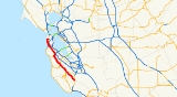
California State Route 35
Encyclopedia
State Route 35 in the U.S. state
of California
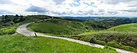
, generally known as Skyline Boulevard, is a two-lane road
running along the western ridge of Silicon Valley
in California
. It runs from Highway 17 to San Francisco
at State Route 1. It provides scenic views of both the Santa Cruz Mountains
, the Silicon Valley
Metropolitan Area, Half Moon Bay
, and San Francisco Bay
. Because of its high elevation and location it is one of the few places on the Bay Area's southern peninsula from which the San Francisco Bay and the Pacific Ocean
are both visible at the same time. A notable feature of Skyline Boulevard is historic Kings Mountain
in Woodside
. Skyline Blvd. offers views of Half Moon Bay
as it summits Kings Mountain.
It was originally designated State Route 5, but this was changed with the creation of Interstate 5 in 1964, to avoid confusion.
and is eligible for the State Scenic Highway System
. However, only the portion from the Santa Cruz-Santa Clara county line to the SR 92 junction is actually a state highway.
The highway begins at the junction of Summit Road and State Route 17. It follows Summit Road up until Bear Creek Road, which bears Route 35 for a few miles until Skyline Boulevard is reached. It bears the name Skyline Boulevard for a majority of its route along the ridge
of the Santa Cruz Mountains
to the west of Silicon Valley
, passing cities such as San Jose
, Saratoga
, and Palo Alto
. The road reaches its highest elevation near Sanborn Skyline County Park at about 3,000 ft (914 m). The ridge that the road follows forms the border between Santa Cruz
and Santa Clara
counties. However, the boundary is so irregular that the road weaves in and out of the two counties.
The ridgetop portion of the route ends at the junction with State Route 92
, because this northern area of the Santa Cruz Mountains is a protected watershed
owned by the San Francisco Water Department
. Highway 35 is co-routed
with SR 92 for 2 miles (3 km) east, descending towards Crystal Springs Reservoir
, which it crosses on a causeway
, and then joins Interstate 280
northbound for 6 miles (10 km). However, on the southbound side, Route 35 exists as a separate road to the west of the freeway between Bunker Hill Dr. and Route 92, as there is no connector road between 280 South and 92 West.
Route 35 departs from 280 at the southern end of San Bruno
, running to the west of the freeway, regaining the ridgetop separating South San Francisco
and Daly City
from Pacifica
.
It crosses State Route 1
in Daly City and in San Francisco, Skyline Boulevard ends and the highway briefly continues along Sloat Boulevard until it reaches its terminus when it intersects Highway 1 again at 19th Avenue.
 Because of its scenic views and winding roadway, Skyline Boulevard and surrounding roads see substantial recreational motoring and bicycling use. Many sports car
s and motorcycle
s can be found congregating near the intersections with State Route 9 and State Route 84, particularly on weekends. Mountain bike
rs are also commonly found at the many trailhead
s along the road.
Several public open spaces border on Skyline Boulevard, including Sanborn County Park, Windy Hill
, and the Purisima Open Space; both the latter are parts of the Midpeninsula Regional Open Space District
. Numerous hiking trails originate from parking lots off Skyline in these open spaces.
Whenever there is snow on the road's higher elevations, many people take their families up to see and play in the snow, and therefore, many of the parking lots at regional parks are packed with cars.
's skyline, and also the Pacific Ocean
. One such vista point, Skeggs Point
, is between Kings Mountain
and SR84. The route passes through many of the wildlife refuges along the ridge of Silicon Valley and other parks:
A number of streams originate near Skyline Boulevard, flowing to both Pacific Ocean
and the Bay. Among the bayside streams are San Francisquito Creek
, Redwood Creek
, and San Bruno Creek
.
and West Covina.
{| class=wikitable
!County
!Location
!Postmile
!Exit
!Destinations
!Notes
|-
|rowspan=2|Santa Clara
SCL R0.05-0.23
|
|R0.05
|
|Summit Road
|Continuation beyond SR 17
|-
|
|R0.05
|
|
|Interchange
|-
|Santa Cruz
SCR 0.23-7.68
|
|2.87
|
|Bear Creek Road
|
|-
|Santa Clara
SCL 7.68-17.12
|Saratoga Gap
|14.10
|
|
|
|-
|rowspan=21|San Mateo
SM 2.12-23.04
|
|3.21
|
|Alpine Road, Page Mill Road
|
|-
|Woodside
|10.52
|
|
|
|-
|
|16.22
|
|Kings Mountain Road, Tunitas Creek Road
|
|-
|
|bgcolor=#ddffdd|23.04
5.19Indicates that the postmile represents the distance along SR 92
rather than SR 35.
|bgcolor=#ddffdd|
|bgcolor=#ddffdd|
|bgcolor=#ddffdd|South end of SR 92 overlap
|-
|
|bgcolor=#ddffdd|7.19
L21.72
|bgcolor=#ddffdd|
|bgcolor=#ddffdd|
|bgcolor=#ddffdd|North end of SR 92 overlap
|-
|
|bgcolor=#ddffdd|L22.76
R12.32Indicates that the postmile represents the distance along I-280
rather than SR 35.
|bgcolor=#ddffdd|
|bgcolor=#ddffdd|
|bgcolor=#ddffdd|Interchange; south end of I-280 overlap
|-
|colspan=5 align=center|South end of freeway on I-280
|-
|Hillsborough
|R14.22
|36
|Black Mountain Road, Hayne Road
|
|-
|
|R17.16
|39
|Trousdale Drive – Burlingame
|
|-
|rowspan=2|Millbrae
|bgcolor=#ffdddd|R17.92
|bgcolor=#ffdddd|40
|bgcolor=#ffdddd|Millbrae Avenue
|bgcolor=#ffdddd|Northbound exit and southbound entrance
|-bgcolor=#ffdddd
|R18.52
|41
|Larkspur Drive, Millbrae Avenue
|Southbound exit and northbound entrance
|-
|colspan=5 align=center|North end of freeway on I-280
|-
|rowspan=3|San Bruno
|bgcolor=#ddffdd|R19.28
R23.04
|bgcolor=#ddffdd|
|bgcolor=#ddffdd|
|bgcolor=#ddffdd|Interchange; north end of I-280 overlap; northbound exit and southbound entrance
|-
|24.35
|
|San Bruno Avenue
|
|-
|24.85
|
|Sneath Lane
|
|-
|San Bruno
, Pacifica
|26.23
|
|Westborough Boulevard, Sharp Park Road – Pacifica
|
|-
|rowspan=2|Pacifica
, Daly City
|28.27
|
|Hickey Boulevard
|
|-
|colspan=4 align=center|South end of freeway
|-
|rowspan=3|Daly City
|R28.69
|54
|
|Signed as exits 54A (north) and 54B (south)
|-
|colspan=4 align=center|North end of freeway
|-
|30.83
|
|John Daly Boulevard – Westlake District
|
|-
|colspan=2 rowspan=5|San Francisco
SF 0.00-3.16
|
|
|Great Highway
– Beach
|
|-
|1.83
|
|Sloat Boulevard
|
|-
|2.12
|
|Sunset Boulevard
|Interchange
|-
|3.16
|
|, Golden Gate Park
|
|-
|3.16
|
|Sloat Boulevard – San Francisco Civic Center
|Continuation beyond SR 1
U.S. state
A U.S. state is any one of the 50 federated states of the United States of America that share sovereignty with the federal government. Because of this shared sovereignty, an American is a citizen both of the federal entity and of his or her state of domicile. Four states use the official title of...
of California
California
California is a state located on the West Coast of the United States. It is by far the most populous U.S. state, and the third-largest by land area...
, generally known as Skyline Boulevard, is a two-lane road
Road
A road is a thoroughfare, route, or way on land between two places, which typically has been paved or otherwise improved to allow travel by some conveyance, including a horse, cart, or motor vehicle. Roads consist of one, or sometimes two, roadways each with one or more lanes and also any...
running along the western ridge of Silicon Valley
Silicon Valley
Silicon Valley is a term which refers to the southern part of the San Francisco Bay Area in Northern California in the United States. The region is home to many of the world's largest technology corporations...
in California
California
California is a state located on the West Coast of the United States. It is by far the most populous U.S. state, and the third-largest by land area...
. It runs from Highway 17 to San Francisco
San Francisco, California
San Francisco , officially the City and County of San Francisco, is the financial, cultural, and transportation center of the San Francisco Bay Area, a region of 7.15 million people which includes San Jose and Oakland...
at State Route 1. It provides scenic views of both the Santa Cruz Mountains
Santa Cruz Mountains
The Santa Cruz Mountains, part of the Pacific Coast Ranges, are a mountain range in central California, United States. They form a ridge along the San Francisco Peninsula, south of San Francisco, separating the Pacific Ocean from San Francisco Bay and the Santa Clara Valley, and continuing south,...
, the Silicon Valley
Silicon Valley
Silicon Valley is a term which refers to the southern part of the San Francisco Bay Area in Northern California in the United States. The region is home to many of the world's largest technology corporations...
Metropolitan Area, Half Moon Bay
Half Moon Bay, California
Half Moon Bay is a coastal city in San Mateo County, California, USA. Its population was 11,324 as of the 2010 census. Immediately at the north of Half Moon Bay is the Pillar Point Harbor and the unincorporated community of Princeton-by-the-Sea....
, and San Francisco Bay
San Francisco Bay
San Francisco Bay is a shallow, productive estuary through which water draining from approximately forty percent of California, flowing in the Sacramento and San Joaquin rivers from the Sierra Nevada mountains, enters the Pacific Ocean...
. Because of its high elevation and location it is one of the few places on the Bay Area's southern peninsula from which the San Francisco Bay and the Pacific Ocean
Pacific Ocean
The Pacific Ocean is the largest of the Earth's oceanic divisions. It extends from the Arctic in the north to the Southern Ocean in the south, bounded by Asia and Australia in the west, and the Americas in the east.At 165.2 million square kilometres in area, this largest division of the World...
are both visible at the same time. A notable feature of Skyline Boulevard is historic Kings Mountain
Kings Mountain, California
Kings Mountain is an unincorporated community in San Mateo County, California, located along State Route 35 between Skeggs Point and Pise Mountain. This is about seven miles north of Woodside Road . In the U.S...
in Woodside
Woodside, California
Woodside is a small incorporated town in San Mateo County, California, United States, on the San Francisco Peninsula. It uses a council-manager system of government. The U.S. Census estimated the population of the town to be 5,287 in 2010....
. Skyline Blvd. offers views of Half Moon Bay
Half Moon Bay, California
Half Moon Bay is a coastal city in San Mateo County, California, USA. Its population was 11,324 as of the 2010 census. Immediately at the north of Half Moon Bay is the Pillar Point Harbor and the unincorporated community of Princeton-by-the-Sea....
as it summits Kings Mountain.
It was originally designated State Route 5, but this was changed with the creation of Interstate 5 in 1964, to avoid confusion.
Route description
This route is part of the California Freeway and Expressway SystemCalifornia Freeway and Expressway System
The California Freeway and Expressway System is a system of existing or planned freeways and expressways in the U.S. state of California. It is defined by the Streets and Highways Code.-List of roads in the system:*State Route 1 *State Route 2...
and is eligible for the State Scenic Highway System
State Scenic Highway System (California)
The State Scenic Highway System is a list of highways, mainly state highways, that have been designated by the California Department of Transportation as scenic highways. The California State Legislature, primarily through Section 263 of the Streets and Highways Code, makes highways eligible for...
. However, only the portion from the Santa Cruz-Santa Clara county line to the SR 92 junction is actually a state highway.
The highway begins at the junction of Summit Road and State Route 17. It follows Summit Road up until Bear Creek Road, which bears Route 35 for a few miles until Skyline Boulevard is reached. It bears the name Skyline Boulevard for a majority of its route along the ridge
Ridge
A ridge is a geological feature consisting of a chain of mountains or hills that form a continuous elevated crest for some distance. Ridges are usually termed hills or mountains as well, depending on size. There are several main types of ridges:...
of the Santa Cruz Mountains
Santa Cruz Mountains
The Santa Cruz Mountains, part of the Pacific Coast Ranges, are a mountain range in central California, United States. They form a ridge along the San Francisco Peninsula, south of San Francisco, separating the Pacific Ocean from San Francisco Bay and the Santa Clara Valley, and continuing south,...
to the west of Silicon Valley
Silicon Valley
Silicon Valley is a term which refers to the southern part of the San Francisco Bay Area in Northern California in the United States. The region is home to many of the world's largest technology corporations...
, passing cities such as San Jose
San Jose, California
San Jose is the third-largest city in California, the tenth-largest in the U.S., and the county seat of Santa Clara County which is located at the southern end of San Francisco Bay...
, Saratoga
Saratoga, California
Saratoga is a city in Santa Clara County, California, USA. It is located on the west side of the Santa Clara Valley, directly west of San Jose, in the San Francisco Bay area. The population was 29,926 at the 2010 census....
, and Palo Alto
Palo Alto, California
Palo Alto is a California charter city located in the northwest corner of Santa Clara County, in the San Francisco Bay Area of California, United States. The city shares its borders with East Palo Alto, Mountain View, Los Altos, Los Altos Hills, Stanford, Portola Valley, and Menlo Park. It is...
. The road reaches its highest elevation near Sanborn Skyline County Park at about 3,000 ft (914 m). The ridge that the road follows forms the border between Santa Cruz
Santa Cruz County, California
Santa Cruz County is a county located on the Pacific coast of the U.S. state of California, on the California Central Coast. The county forms the northern coast of the Monterey Bay. . As of the 2010 U.S. Census, its population was 262,382. The county seat is Santa Cruz...
and Santa Clara
Santa Clara County, California
Santa Clara County is a county located at the southern end of the San Francisco Bay Area in the U.S. state of California. As of 2010 it had a population of 1,781,642. The county seat is San Jose. The highly urbanized Santa Clara Valley within Santa Clara County is also known as Silicon Valley...
counties. However, the boundary is so irregular that the road weaves in and out of the two counties.
The ridgetop portion of the route ends at the junction with State Route 92
California State Route 92
State Route 92 is an east-west highway in the San Francisco Bay area between Half Moon Bay near the coast in the west and downtown Hayward at its junction with State Route 238 and State Route 185. It is most notable for being the route that traverses the San Mateo Bridge. It has interchanges with...
, because this northern area of the Santa Cruz Mountains is a protected watershed
Drainage basin
A drainage basin is an extent or an area of land where surface water from rain and melting snow or ice converges to a single point, usually the exit of the basin, where the waters join another waterbody, such as a river, lake, reservoir, estuary, wetland, sea, or ocean...
owned by the San Francisco Water Department
San Francisco Water Department
The San Francisco Water Department is an agency in San Francisco that provides water service to residents of the San Francisco Bay Area. The San Francisco Water Department privately holds substantial amounts of undeveloped land in many parts of the San Francisco Bay Area.Since the mid-19th century...
. Highway 35 is co-routed
Concurrency (road)
A concurrency, overlap, or coincidence in a road network is an instance of one physical road bearing two or more different highway, motorway, or other route numbers...
with SR 92 for 2 miles (3 km) east, descending towards Crystal Springs Reservoir
Crystal Springs Reservoir
Crystal Springs Reservoir is a pair of artificial lakes located in the northern Santa Cruz Mountains of San Mateo County, California situated in the rift valley created by the San Andreas Fault just to the west of the cities of San Mateo and Hillsborough, and I-280...
, which it crosses on a causeway
Causeway
In modern usage, a causeway is a road or railway elevated, usually across a broad body of water or wetland.- Etymology :When first used, the word appeared in a form such as “causey way” making clear its derivation from the earlier form “causey”. This word seems to have come from the same source by...
, and then joins Interstate 280
Interstate 280 (California)
Interstate 280 is a 57-mile long north–south Interstate Highway in the San Francisco Bay Area of Northern California. It connects San Jose and San Francisco, running along just to the west of the cities of San Francisco Peninsula for most of its route.I-280 from its northern end at King...
northbound for 6 miles (10 km). However, on the southbound side, Route 35 exists as a separate road to the west of the freeway between Bunker Hill Dr. and Route 92, as there is no connector road between 280 South and 92 West.
Route 35 departs from 280 at the southern end of San Bruno
San Bruno, California
San Bruno is a city in San Mateo County, California, United States. The population was 41,114 at the 2010 census.The city is adjacent to San Francisco International Airport and Golden Gate National Cemetery.-Geography:San Bruno is located at...
, running to the west of the freeway, regaining the ridgetop separating South San Francisco
South San Francisco, California
South San Francisco is a city in San Mateo County, California, United States, located on the San Francisco Peninsula in the San Francisco Bay Area...
and Daly City
Daly City, California
Daly City is the largest city in San Mateo County, California, United States, with a 2010 population of 101,123. Located immediately south of San Francisco, it is named in honor of businessman and landowner John Daly.-History:...
from Pacifica
Pacifica, California
Pacifica is a city in San Mateo County, California, on the coast of the Pacific Ocean between San Francisco and Half Moon Bay.-Overview:The City of Pacifica is spread along a six mile stretch of the north central California coastal beach and hills, nestled in several small valleys spanning between...
.
It crosses State Route 1
California State Route 1
State Route 1 , more often called Highway 1, is a state highway that runs along much of the Pacific coast of the U.S. state of California. It is famous for running along some of the most beautiful coastlines in the world, leading to its designation as an All-American Road.Highway 1 does not run...
in Daly City and in San Francisco, Skyline Boulevard ends and the highway briefly continues along Sloat Boulevard until it reaches its terminus when it intersects Highway 1 again at 19th Avenue.
Recreational use
Sports car
A sports car is a small, usually two seat, two door automobile designed for high speed driving and maneuverability....
s and motorcycle
Motorcycle
A motorcycle is a single-track, two-wheeled motor vehicle. Motorcycles vary considerably depending on the task for which they are designed, such as long distance travel, navigating congested urban traffic, cruising, sport and racing, or off-road conditions.Motorcycles are one of the most...
s can be found congregating near the intersections with State Route 9 and State Route 84, particularly on weekends. Mountain bike
Mountain bike
A mountain bike or mountain bicycle is a bicycle created for off-road cycling. This activity includes traversing of rocks and washouts, and steep declines,...
rs are also commonly found at the many trailhead
Trailhead
A trailhead is the point at which a trail begins, where the trail is often intended for hiking, biking, horseback riding, or off-road vehicles...
s along the road.
Several public open spaces border on Skyline Boulevard, including Sanborn County Park, Windy Hill
Windy Hill Open Space Preserve
Windy Hill Open Space Preserve is a regional park located in San Mateo County, California and operated by the Midpeninsula Regional Open Space District...
, and the Purisima Open Space; both the latter are parts of the Midpeninsula Regional Open Space District
Midpeninsula Regional Open Space District
The Midpeninsula Regional Open Space District is a special-purpose district that manages over of open space in 25 preserves in the San Francisco Bay Area. It includes parts of Santa Clara, San Mateo and Santa Cruz Counties. The District was created by voter initiative in 1972...
. Numerous hiking trails originate from parking lots off Skyline in these open spaces.
Whenever there is snow on the road's higher elevations, many people take their families up to see and play in the snow, and therefore, many of the parking lots at regional parks are packed with cars.
Other landmarks
For most the of the route, State Route 35 offers vistas of both Silicon ValleySilicon Valley
Silicon Valley is a term which refers to the southern part of the San Francisco Bay Area in Northern California in the United States. The region is home to many of the world's largest technology corporations...
's skyline, and also the Pacific Ocean
Pacific Ocean
The Pacific Ocean is the largest of the Earth's oceanic divisions. It extends from the Arctic in the north to the Southern Ocean in the south, bounded by Asia and Australia in the west, and the Americas in the east.At 165.2 million square kilometres in area, this largest division of the World...
. One such vista point, Skeggs Point
Skeggs Point, California
Skeggs Point is a scenic turnout in San Mateo County along State Route 35 between Kings Mountain and State Route 84. The feature is marked with a guide sign along the road and is listed on the USGS 7.5 minute quadrangle, "Woodside, California" as well as in the National Geographic Names Database...
, is between Kings Mountain
Kings Mountain, California
Kings Mountain is an unincorporated community in San Mateo County, California, located along State Route 35 between Skeggs Point and Pise Mountain. This is about seven miles north of Woodside Road . In the U.S...
and SR84. The route passes through many of the wildlife refuges along the ridge of Silicon Valley and other parks:
- Sanborn-Skyline County Park
- Castle Rock State ParkCastle Rock State Park (California)Castle Rock State Park is a state park of California, USA, located along the crest of the Santa Cruz Mountains. It embraces coast redwood, Douglas fir, and madrone forest, most of which has been left in its wild, natural state. Steep canyons are sprinkled with unusual rock formations that is a...
- Saratoga Gap Open Space PreserveSaratoga Gap Open Space PreserveSaratoga Gap Open Space Preserve is a 1291-acre regional park located near Saratoga Gap in the Santa Cruz Mountains of Santa Clara County, California. The preserve is owned and operated by the Midpeninsula Regional Open Space District...
- Windy Hill Open Space PreserveWindy Hill Open Space PreserveWindy Hill Open Space Preserve is a regional park located in San Mateo County, California and operated by the Midpeninsula Regional Open Space District...
- Wunderlich County Park
- El Corte de Madera Creek Open Space Preserve
- Huddart County Park
- Purisima Creek Redwoods Open Space Preserve
A number of streams originate near Skyline Boulevard, flowing to both Pacific Ocean
Pacific Ocean
The Pacific Ocean is the largest of the Earth's oceanic divisions. It extends from the Arctic in the north to the Southern Ocean in the south, bounded by Asia and Australia in the west, and the Americas in the east.At 165.2 million square kilometres in area, this largest division of the World...
and the Bay. Among the bayside streams are San Francisquito Creek
San Francisquito Creek
San Francisquito Creek is a creek that flows into southwest San Francisco Bay in California, United States of America. Historically it was called the Arroyo de San Francisco by Juan Bautista de Anza in 1776...
, Redwood Creek
Redwood Creek, San Mateo County
Redwood Creek is a stream in San Mateo County, California, USA which discharges into South San Francisco Bay. The Port of Redwood City, the largest deepwater port in South San Francisco Bay, is situated on the east bank of Redwood Creek near its mouth. Extensive mudflats and marsh areas are found...
, and San Bruno Creek
San Bruno Creek
San Bruno Creek is an intermittent stream that rises on the eastern slopes of the Northern Santa Cruz Mountains in San Mateo County, California, USA. The headwaters descend a relatively steep canyon east of Skyline Boulevard in a tortuous course...
.
History
As old highway maps show, State Route 35 was originally designated State Route 5. The number was changed in the 1964 renumbering. The original state route 35 ran north to south from State Route 22 to U.S. 99, first along Los Alamitos Blvd. going north which turns into Norwalk Blvd. The highway continued west on Centralia Road and then north along Pioneer Blvd. until hiting San Antonio drive at Rosecrans Ave. San Antonio Dr. would turn back into Norwalk blvd. and Route 35 would continue turning into Old Mill Road at Beverly Blvd. Route 35 would wind through Rose Hills and Avocado Heights and would then turn into Puente Ave. at Valley Blvd. and continue to Route 99 where Route 35 ended at the border of Baldwin ParkBaldwin Park
Baldwin Park is the name of some places in the United States:* Baldwin Park, California* Baldwin Park, Missouri* An upscale housing project in Orlando, Florida*Baldwin Park...
and West Covina.
Major intersections
- Note: Except where prefixed with a letter, postmiles were measured in 1964, based on the alignment as it existed at that time, and do not necessarily reflect current mileage. The numbers reset at some county lines; the start and end postmiles in each county are given in the county column.
{| class=wikitable
!County
!Location
!Postmile
!Exit
Exit number
An exit number is a number assigned to a road junction, usually an exit from a freeway. It is usually marked on the same sign as the destinations of the exit, as well as a sign in the gore....
!Destinations
!Notes
|-
|rowspan=2|Santa Clara
Santa Clara County, California
Santa Clara County is a county located at the southern end of the San Francisco Bay Area in the U.S. state of California. As of 2010 it had a population of 1,781,642. The county seat is San Jose. The highly urbanized Santa Clara Valley within Santa Clara County is also known as Silicon Valley...
SCL R0.05-0.23
|
|R0.05
|
|Summit Road
|Continuation beyond SR 17
|-
|
|R0.05
|
|
|Interchange
|-
|Santa Cruz
Santa Cruz County, California
Santa Cruz County is a county located on the Pacific coast of the U.S. state of California, on the California Central Coast. The county forms the northern coast of the Monterey Bay. . As of the 2010 U.S. Census, its population was 262,382. The county seat is Santa Cruz...
SCR 0.23-7.68
|
|2.87
|
|Bear Creek Road
|
|-
|Santa Clara
Santa Clara County, California
Santa Clara County is a county located at the southern end of the San Francisco Bay Area in the U.S. state of California. As of 2010 it had a population of 1,781,642. The county seat is San Jose. The highly urbanized Santa Clara Valley within Santa Clara County is also known as Silicon Valley...
SCL 7.68-17.12
|Saratoga Gap
|14.10
|
|
|
|-
|rowspan=21|San Mateo
San Mateo County, California
San Mateo County is a county located in the San Francisco Bay Area of the U.S. state of California. It covers most of the San Francisco Peninsula just south of San Francisco, and north of Santa Clara County. San Francisco International Airport is located at the northern end of the county, and...
SM 2.12-23.04
|
|3.21
|
|Alpine Road, Page Mill Road
|
|-
|Woodside
Woodside, California
Woodside is a small incorporated town in San Mateo County, California, United States, on the San Francisco Peninsula. It uses a council-manager system of government. The U.S. Census estimated the population of the town to be 5,287 in 2010....
|10.52
|
|
|
|-
|
|16.22
|
|Kings Mountain Road, Tunitas Creek Road
|
|-
|
|bgcolor=#ddffdd|23.04
5.19Indicates that the postmile represents the distance along SR 92
California State Route 92
State Route 92 is an east-west highway in the San Francisco Bay area between Half Moon Bay near the coast in the west and downtown Hayward at its junction with State Route 238 and State Route 185. It is most notable for being the route that traverses the San Mateo Bridge. It has interchanges with...
rather than SR 35.
|bgcolor=#ddffdd|
|bgcolor=#ddffdd|
|bgcolor=#ddffdd|South end of SR 92 overlap
|-
|
|bgcolor=#ddffdd|7.19
L21.72
|bgcolor=#ddffdd|
|bgcolor=#ddffdd|
|bgcolor=#ddffdd|North end of SR 92 overlap
|-
|
|bgcolor=#ddffdd|L22.76
R12.32Indicates that the postmile represents the distance along I-280
Interstate 280 (California)
Interstate 280 is a 57-mile long north–south Interstate Highway in the San Francisco Bay Area of Northern California. It connects San Jose and San Francisco, running along just to the west of the cities of San Francisco Peninsula for most of its route.I-280 from its northern end at King...
rather than SR 35.
|bgcolor=#ddffdd|
|bgcolor=#ddffdd|
|bgcolor=#ddffdd|Interchange; south end of I-280 overlap
|-
|colspan=5 align=center|South end of freeway on I-280
|-
|Hillsborough
Hillsborough, California
Hillsborough is an incorporated town in San Mateo County, California, in the San Francisco Bay Area. Hillsborough is one of the wealthiest communities in America and has the highest income of places in the United States with populations of at least 10,000...
|R14.22
|36
|Black Mountain Road, Hayne Road
|
|-
|
|R17.16
|39
|Trousdale Drive – Burlingame
Burlingame, California
Burlingame is a city in San Mateo County, California. It is located on the San Francisco Peninsula and has a significant shoreline on San Francisco Bay. The city is named after diplomat Anson Burlingame. It is renowned for its many surviving examples of Victorian architecture, its affluence, and...
|
|-
|rowspan=2|Millbrae
Millbrae, California
Millbrae is a city in San Mateo County, California, United States, just west of San Francisco Bay, with San Bruno on the north and Burlingame on the south. The population was 21,532 at the 2010 census.-History:...
|bgcolor=#ffdddd|R17.92
|bgcolor=#ffdddd|40
|bgcolor=#ffdddd|Millbrae Avenue
|bgcolor=#ffdddd|Northbound exit and southbound entrance
|-bgcolor=#ffdddd
|R18.52
|41
|Larkspur Drive, Millbrae Avenue
|Southbound exit and northbound entrance
|-
|colspan=5 align=center|North end of freeway on I-280
|-
|rowspan=3|San Bruno
San Bruno, California
San Bruno is a city in San Mateo County, California, United States. The population was 41,114 at the 2010 census.The city is adjacent to San Francisco International Airport and Golden Gate National Cemetery.-Geography:San Bruno is located at...
|bgcolor=#ddffdd|R19.28
R23.04
|bgcolor=#ddffdd|
|bgcolor=#ddffdd|
|bgcolor=#ddffdd|Interchange; north end of I-280 overlap; northbound exit and southbound entrance
|-
|24.35
|
|San Bruno Avenue
|
|-
|24.85
|
|Sneath Lane
|
|-
|San Bruno
San Bruno, California
San Bruno is a city in San Mateo County, California, United States. The population was 41,114 at the 2010 census.The city is adjacent to San Francisco International Airport and Golden Gate National Cemetery.-Geography:San Bruno is located at...
, Pacifica
Pacifica, California
Pacifica is a city in San Mateo County, California, on the coast of the Pacific Ocean between San Francisco and Half Moon Bay.-Overview:The City of Pacifica is spread along a six mile stretch of the north central California coastal beach and hills, nestled in several small valleys spanning between...
|26.23
|
|Westborough Boulevard, Sharp Park Road – Pacifica
Pacifica, California
Pacifica is a city in San Mateo County, California, on the coast of the Pacific Ocean between San Francisco and Half Moon Bay.-Overview:The City of Pacifica is spread along a six mile stretch of the north central California coastal beach and hills, nestled in several small valleys spanning between...
|
|-
|rowspan=2|Pacifica
Pacifica, California
Pacifica is a city in San Mateo County, California, on the coast of the Pacific Ocean between San Francisco and Half Moon Bay.-Overview:The City of Pacifica is spread along a six mile stretch of the north central California coastal beach and hills, nestled in several small valleys spanning between...
, Daly City
Daly City, California
Daly City is the largest city in San Mateo County, California, United States, with a 2010 population of 101,123. Located immediately south of San Francisco, it is named in honor of businessman and landowner John Daly.-History:...
|28.27
|
|Hickey Boulevard
|
|-
|colspan=4 align=center|South end of freeway
|-
|rowspan=3|Daly City
Daly City, California
Daly City is the largest city in San Mateo County, California, United States, with a 2010 population of 101,123. Located immediately south of San Francisco, it is named in honor of businessman and landowner John Daly.-History:...
|R28.69
|54
|
|Signed as exits 54A (north) and 54B (south)
|-
|colspan=4 align=center|North end of freeway
|-
|30.83
|
|John Daly Boulevard – Westlake District
Westlake, Daly City, California
The Westlake District of Daly City, California, is one of the first post-World War II suburbs in the United States. Located just south of San Francisco, Westlake has frequently been compared to Levittown, New York, the first major large-scale postwar middle-class housing development in the...
|
|-
|colspan=2 rowspan=5|San Francisco
San Francisco, California
San Francisco , officially the City and County of San Francisco, is the financial, cultural, and transportation center of the San Francisco Bay Area, a region of 7.15 million people which includes San Jose and Oakland...
SF 0.00-3.16
|
|
|Great Highway
Great Highway
The Great Highway is a road in San Francisco that forms the city's western edge along the Pacific coast. It runs for approximately next to Ocean Beach...
– Beach
|
|-
|1.83
|
|Sloat Boulevard
|
|-
|2.12
|
|Sunset Boulevard
|Interchange
|-
|3.16
|
|, Golden Gate Park
Golden Gate Park
Golden Gate Park, located in San Francisco, California, is a large urban park consisting of of public grounds. Configured as a rectangle, it is similar in shape but 20% larger than Central Park in New York, to which it is often compared. It is over three miles long east to west, and about half a...
|
|-
|3.16
|
|Sloat Boulevard – San Francisco Civic Center
Civic Center, San Francisco, California
The Civic Center in San Francisco, California, is an area of a few blocks north of the intersection of Market Street and Van Ness Avenue that contains many of the city's largest government and cultural institutions. It has two large plazas and a number of buildings in classical architectural style...
|Continuation beyond SR 1
External links
- WestCoast Roads- State Route 35
- Caltrans: Route 35 highway conditions
- California Highways: SR 35
- National Scenic Byways Program page about the route
- Skyline Motorcycle Map at SundayMorningRides.com