
.gif)
Interstate 680 (California)
Encyclopedia
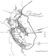
Interstate 680 is a north–south Interstate Highway
in Northern California
. It curves around the eastern cities of the San Francisco Bay Area
from San Jose
to Interstate 80 at Cordelia, bypassing cities along the eastern shore of San Francisco Bay
such as Oakland
and Richmond
while serving others more inland such as Pleasanton
and Concord
.
Built in the 1920s and designated in 1955, I-680 begins at a junction with I-280
and US 101 (Bayshore Freeway
), and heads northeast and north-northwest through the northeast part of San Jose. After passing SR 237
in Milpitas
and SR 262
in Fremont
, I-680 abruptly turns northeast (where a connection to a SR 238
freeway was planned) and enters a hilly area. The highway crosses over Mission Pass, also known as the Sunol Grade, and descends into the Sunol Valley
, where it meets SR 84
near Sunol
. From Sunol, I-680 again heads north-northwesterly through valleys, including the San Ramon Valley
, along the Calaveras Fault
. Junctions along this portion include I-580
in Dublin
and SR 24
in Walnut Creek
. Beyond the latter interchange, a three-way directional junction with the SR 24 freeway west to Oakland
, I-680 heads north into Pleasant Hill
, where SR 242
splits and I-680 again heads northwesterly. After the junction with SR 4 in Martinez
, the highway crosses the Carquinez Strait
on the Benicia-Martinez Bridge
, immediately meeting the east end of I-780 on the Benicia
end. The remainder of I-680, from Benicia to I-80 at Cordelia, lies between a hilly area to the west and a marsh
y area (along the Suisun Bay
and Cordelia Slough
) to the east.
I-680 is part of the State Scenic Highway System
from SR 238
in Fremont
north to SR 24
in Walnut Creek
, and is eligible for said system from SR 238 south to the Alameda
-Santa Clara County
line.
Between Alcosta Boulevard and the intersection with I-580 , I-680 is officially named the "Officer John Paul Monego Memorial Freeway." It was named after Dublin Police Officer John Paul Monego, who died on December 12, 1998, in the line of duty at the age of 33 years, while responding to a takeover robbery. Named by Senate Concurrent Resolution 60, enrolled August 18, 2000.
From Route 24 to Route 4, the route is historically part of "El Camino Sierra" (The Road to the Mountains).
The portion of this route from about the Livorna Road interchange in Walnut Creek/Alamo to the Alcosta Blvd. interchange in San Ramon appears to be named the "Donald D. Doyle Highway". While serving in the California Assembly from 1953 to 1958, Donald D. Doyle co-authored the Short-Doyle Mental Health Act and authored legislation creating the ferry boat transportation system between Benecia and Martinez. The signs indicating this were erected in 1998.
Of the above names, only the name Sinclair Freeway for its designated portion usually appears on maps, and the other portions on maps are always unnamed, referred to as simply I-680.
The route begins at U.S. Route 101, where it acts as a continuation of Interstate 280
eastward. From here, it begins its journey northward through San Jose
, where it meets the Capitol Expressway, signed as County Route G21. The next exit northbound is State Route 130
, which is also known as Alum Rock Avenue. As it continues through Santa Clara County
, it meets numerous local roads before interchanging with the Montague Expressway. Here, it exits San Jose and enters the city of Milpitas, California
, where it meets State Route 237
, often referred to as Calaveras Boulevard. After one more intersection, I-680 exits Santa Clara County and enters Alameda County
.
In Alameda County, the freeway instantly begins in the city of Fremont
, where it intersects State Route 262
. Continuing through the city, it meets Mission Boulevard at State Route 238
before exiting the city. Amid Alameda County, it abruptly turns northeastward and enters a hilly area, where it crosses over Mission Pass, and descends into the Sunol Valley
, where it joins State Route 84
for a short while. Afterwards, it enters Pleasanton
and interchanges with Interstate 580
. It enters Dublin
for a short segment before exiting the county and entering Contra Costa County
.
Upon entering Contra Costa County, the route meets numerous local roads through the cities of San Ramon
, Danville
, and Alamo
before entering Walnut Creek
, where it meets State Route 24
. I-680 then enters Concord
, where it meets State Route 242
. Upon exiting Concord, it meets State Route 4. It then enters Martinez
, where it follows the Benicia-Martinez Bridge
over the Carquinez Strait
, on which the route crosses the county line and enters Benicia
in Solano County
. In Bencia, I-680 interchanges with Interstate 780. It then exits the city and enters Fairfield
, where it meets Interstate 80
, where the route finds its north terminus.
In the wake of the September 11 Attacks, a flag was painted on a large piece of concrete on a hill along the Sunol Grade. It stayed there for nine years before being painted over, as the mural had been
painted without authorization. Due to this action being taken shortly before the 4th of July
, and also due to the mural's fame, this was met with controversy. The flag was replaced shortly later.
through Walnut Creek
, Dublin
, Danville
, and Sunol
to Mission San Jose, where it met State Highway Route 5 (Mission Boulevard, signed over the years as US 48, US 101E, SR 9
, and now SR 238
). It was not yet paved south of Dublin, where it crossed Mission Pass between the Sunol Valley
and the San Francisco Bay basin. The majority of this roadway was added to the state highway system in 1933 as portions of several routes: Route 108 from Mission San Jose to Sunol, Route 107 from Sunol to Walnut Creek, and Route 75 from Walnut Creek to Pleasant Hill
.
At Martinez, the Martinez-Benicia Ferry took automobiles across the Carquinez Strait
to Benicia
, where Route 7, one of the original state highways from the 1910 bond issue, led north and northeast past Cordelia towards Sacramento
and Oregon
. The portion north from Benicia to Cordelia became part of Route 74 in 1935, when Route 7 was realigned to the more direct American Canyon route that is now I-80. None of the aforementioned roads were given state sign route numbers in 1934, when that system was laid out, but by 1937 they had been numbered State Route 21. This route began at the intersection of Warm Springs Boulevard and Brown Road in Warm Springs
, where Route 5 and Route 69 (SR 17) split, follewed Route 5 along Mission Boulevard to Mission San Jose (this part later became an overlap with SR 9
), and then continued to US 40 (Route 7) at Cordelia. The routing was very close to the present I-680, following such roads as Pleasanton Sunol Road, San Ramon Valley Boulevard, Danville Boulevard, and Pacheco Boulevard.
The portion of SR 21 between Pleasant Hill and Martinez was finally added to the state highway system in 1949, as a branch of Route 75. The ferry approach in Benicia became a spur of Route 74 in 1947, and in 1953 it was transferred to Route 75. The same law, effective immediately as an urgency measure, authorized the Department of Public Works to acquire the ferry system, then operated by the city of Martinez, which was planning to shut it down. Ownership was transferred just after midnight on October 6, 1953.
 The Bureau of Public Roads approved urban routes of the Interstate Highway System
on September 15, 1955, including a loop around the San Francisco Bay
, soon numbered I-280
and I-680. The east half (I-680) began at the interchange of US 101 north of downtown San Jose and followed the Nimitz Freeway (SR 17/Route 69, now I-880) to the split at Warm Springs
(the present location of SR 262
), SR 21 to Benicia, and Route 74 (no sign route number) to I-80 in Vallejo
. The first piece of I-680 freeway built, other than the pre-existing Nimitz Freeway, was in the late 1950s, along the SR 24
overlap between North Main Street in Walnut Creek
and Monument Boulevard in Pleasant Hill
. A southerly extension, bypassing downtown Walnut Creek to South Main Street, opened on March 22, 1960, connecting with the SR 24 freeway to Oakland
. In the next decade, the freeway was completed from Vallejo south to SR 238
at Mission San Jose, and the roadway north from Benicia to Cordelia, which became the only remaining piece of SR 21, was also upgraded to freeway standards.
In the 1964 renumbering, the legislative designation was changed to Route 680. SR 17 was officially moved to former Route 5 between San Jose and Warm Springs, which had not had a signed designation since the Nimitz Freeway (then I-680) was constructed, but this was instead marked as part of SR 238
(which replaced SR 9
north of Mission San Jose), and SR 17 remained signed along the Nimitz Freeway. This was very short-lived, as the Bureau of Public Roads approved a shift in the south end of I-680 in October 1964. The legislature changed the routes in 1965, swapping Routes 17 and 680 south of Warm Springs, and creating a new SR 262
on the short roadway at Warm Springs where they had overlapped to switch sides. However, until I-680 was completed in the early-to-mid 1970s, it remained signed along the Nimitz Freeway, and the old road between San Jose and Warm Springs continued to be marked as SR 238. One more change was made to the routing of I-680: in July 1973, the remainder of SR 21, from Benicia to Cordelia, was added to the Interstate Highway System. This became the new alignment of I-680, and the old route to Vallejo became I-780. The corresponding changes were made by the state legislature in 1976.
A 14 miles (22.5 km) southbound high-occupancy toll (HOT) lane along I-680 between SR 84 in Alameda County
and SR 237 in Santa Clara County
opened on September 20, 2010. Solo drivers are required to pay a toll via a FasTrak
transponder. There are currently no plans to add northbound HOT lanes on I-680, however.
|rowspan=4|Pleasanton
|R15.26
|25
|Sunol Boulevard, Castlewood Drive – Pleasanton
|
|-
|R16.75
|26
|Bernal Avenue – Pleasanton
|
|-
|R19.30
|29
|Stoneridge Drive
|
|-
|rowspan=2|R20.06
|rowspan=2|30
|rowspan=2|
|rowspan=2|Signed as exits 30A (east) and 30B (west)
|-
|rowspan=2|Dublin
|- style="background:#fdd;"
|R20.39
|30A
|Dublin Boulevard
|No northbound exit; former US 50
|-
|rowspan=26|Contra Costa
CC R0.00-25.46
|rowspan=3|San Ramon
|R0.01
|31
|Alcosta Boulevard – Dublin
|
|-
|R2.89
|34
|Bollinger Canyon Road
|
|-
|rowspan=2|R4.18
|rowspan=2|36
|rowspan=2|Crow Canyon Road – San Ramon
|rowspan=2|
|-
|rowspan=5|Danville
|-
|R6.76
|38
|Sycamore Valley Road
|
|-
|R7.55
|39
|Diablo Road – Danville
|
|-
|R8.18
|40
|El Cerro Boulevard
|
|- style="background:#fdd;"
|R8.75
|41
|El Pintado Road
|Northbound exit is via exit 40; Southbound exit and northbound entrance only
|-
|rowspan=2|Alamo
|R10.37
|42
|Stone Valley Road
|Signed as exits 42A (east) and 42B (west)
|-
|R11.28
|43
|Livorna Road
|
|-
|rowspan=7|Walnut Creek
|R12.61
|44
|Rudgear Road
|Southbound exit is via exit 45A
|- style="background:#fdd;"
|13.08
|45A
|South Main Street – Walnut Creek
|No northbound entrance; former SR 21
|-
|13.93
|45B
|Olympic Boulevard
|
|-
|14.38
|46A
|
|Signed as exit 46 southbound
|- style="background:#fdd;"
|14.85
|46B
|Ygnacio Valley Road
|Northbound exit and southbound entrance
|-
|15.61
|47
|North Main Street – Walnut Creek
|Former SR 21
|-
|16.40
|48
|Treat Boulevard, Geary Road
|
|-
|rowspan=2|Pleasant Hill
| style="background:#fdd;"|R17.29
| style="background:#fdd;"|49A
| style="background:#fdd;"|Contra Costa Boulevard – Pleasant Hill
| style="background:#fdd;"|Northbound exit and southbound entrance; former SR 21
|-
|R17.70
|49B
|Monument Boulevard, Gregory Lane
|Signed as exit 49 southbound; former SR 24
east
|-
|rowspan=3|Concord
,
Pleasant Hill
| style="background:#fdd;"|R18.71
| style="background:#fdd;"|50
| style="background:#fdd;"|
| style="background:#fdd;"|Northbound exit and southbound entrance
|-
|19.04
|51
|Willow Pass Road, Taylor Boulevard
|
|-
|19.86
|52
|Concord Avenue, Burnett Avenue – Pacheco, Concord
|
|-
|
|21.19
|53
|
|
|-
|
|22.43
|54
|Pacheco Boulevard
|Former SR 21
|-
|rowspan=2|Martinez
|24.26
|56
|Marina Vista, Waterfront Boulevard – Martinez
|
|-
| rowspan="2" colspan="4" style="text-align:center;"|Benicia–Martinez Bridge over Carquinez Strait
|-
|rowspan=10|Solano
SOL L0.00-R13.13
|rowspan=5|Benicia
|-
|0.68
|58A
|
|Signed as exit 58 southbound; former I-680 north
|- style="background:#fdd;"
|R1.00
|58B
|Bayshore Road
|Northbound exit and southbound entrance
|- style="background:#fdd;"
|R1.46
|60
|Industrial Park
|Southbound exit and northbound entrance
|-
|R2.82
|61
|Lake Herman Road
|Former SR 21 south
|-
|
|R5.02
|63
|Parish Road
|
|-
|
|R7.32
|65
|Marshview Road
|
|-
|rowspan=3|Fairfield
|R10.02
|68
|Gold Hill Road
|
|- style="background:#fdd;"
|12.63
|70
|Green Valley Road – Cordelia
|Northbound exit and southbound entrance
|-
|13.13
|71
|
|Northbound exit and southbound entrance; signed as exits 71A (east) and 71B (west)
Interstate Highway System
The Dwight D. Eisenhower National System of Interstate and Defense Highways, , is a network of limited-access roads including freeways, highways, and expressways forming part of the National Highway System of the United States of America...
in Northern California
Northern California
Northern California is the northern portion of the U.S. state of California. The San Francisco Bay Area , and Sacramento as well as its metropolitan area are the main population centers...
. It curves around the eastern cities of the San Francisco Bay Area
San Francisco Bay Area
The San Francisco Bay Area, commonly known as the Bay Area, is a populated region that surrounds the San Francisco and San Pablo estuaries in Northern California. The region encompasses metropolitan areas of San Francisco, Oakland, and San Jose, along with smaller urban and rural areas...
from San Jose
San Jose, California
San Jose is the third-largest city in California, the tenth-largest in the U.S., and the county seat of Santa Clara County which is located at the southern end of San Francisco Bay...
to Interstate 80 at Cordelia, bypassing cities along the eastern shore of San Francisco Bay
San Francisco Bay
San Francisco Bay is a shallow, productive estuary through which water draining from approximately forty percent of California, flowing in the Sacramento and San Joaquin rivers from the Sierra Nevada mountains, enters the Pacific Ocean...
such as Oakland
Oakland, California
Oakland is a major West Coast port city on San Francisco Bay in the U.S. state of California. It is the eighth-largest city in the state with a 2010 population of 390,724...
and Richmond
Richmond, California
Richmond is a city in western Contra Costa County, California, United States. The city was incorporated on August 7, 1905. It is located in the East Bay, part of the San Francisco Bay Area. It is a residential inner suburb of San Francisco, as well as the site of heavy industry, which has been...
while serving others more inland such as Pleasanton
Pleasanton, California
Pleasanton is a city in Alameda County, California, incorporated in 1894. It is a suburb in the San Francisco Bay Area located about east of Oakland, and west of Livermore. The population was 70,285 at the 2010 census. In 2005 and 2007, Pleasanton was ranked the wealthiest middle-sized city in...
and Concord
Concord, California
Concord is the largest city in Contra Costa County, California, USA. At the 2010 census, the city had a population of 122,067. Originally founded in 1869 as the community of Todos Santos by Salvio Pacheco, the name was changed to Concord within months...
.
Built in the 1920s and designated in 1955, I-680 begins at a junction with I-280
Interstate 280 (California)
Interstate 280 is a 57-mile long north–south Interstate Highway in the San Francisco Bay Area of Northern California. It connects San Jose and San Francisco, running along just to the west of the cities of San Francisco Peninsula for most of its route.I-280 from its northern end at King...
and US 101 (Bayshore Freeway
Bayshore Freeway
The Bayshore Freeway is a part of U.S. Route 101 in the San Francisco Bay Area of the U.S. state of California. It runs along the west shore of the San Francisco Bay, connecting San Jose with San Francisco. Within the city of San Francisco, the freeway is also known as James Lick Freeway...
), and heads northeast and north-northwest through the northeast part of San Jose. After passing SR 237
California State Route 237
State Route 237 runs from El Camino Real in Mountain View to Interstate 680 in Milpitas. It runs south of the San Francisco Bay, connecting the East Bay to the Peninsula.This route is part of the California Freeway and Expressway System....
in Milpitas
Milpitas, California
Milpitas is a city in Santa Clara County, California. It is a suburb of the major city of San Jose, California. It is located with San Jose to its south and Fremont to its north, at the eastern end of State Route 237 and generally between Interstates 680 and 880 which run roughly north/south...
and SR 262
California State Route 262
State Route 262 is a state highway in the U.S. state of California. More commonly known as Mission Boulevard, SR 262 is a very short state highway that connects two Interstate highways in the San Francisco Bay Area.-Route description:...
in Fremont
Fremont, California
Fremont is a city in Alameda County, California. It was incorporated on January 23, 1956, from the merger of five smaller communities: Centerville, Niles, Irvington, Mission San Jose, and Warm Springs...
, I-680 abruptly turns northeast (where a connection to a SR 238
California State Route 238
State Route 238 is a north–south highway in the U.S. state of California. The route is a divided multilane surface highway in the southeastern part of the San Francisco Bay Area. SR 238 connects Interstate 580 in Castro Valley and Interstate 680 in Fremont.-Route description:SR 238 goes...
freeway was planned) and enters a hilly area. The highway crosses over Mission Pass, also known as the Sunol Grade, and descends into the Sunol Valley
Sunol Valley
Sunol Valley is located in Alameda County, California, USA. The small town of Sunol lies in the valley. It is largely rural, but is in proximity to the highly populated Bay Area suburbs of Fremont, Pleasanton, and Livermore....
, where it meets SR 84
California State Route 84
State Route 84 is a split-section California State Highway consisting of two sections. The first section is an east–west arterial road running from San Gregorio to Menlo Park, across the Dumbarton Bridge through Fremont and Newark and ending at I-580 in Livermore. The route overlaps the...
near Sunol
Sunol, California
Sunol is an unincorporated census-designated place in Alameda County, California, United States. The population was 913 at the 2010 census....
. From Sunol, I-680 again heads north-northwesterly through valleys, including the San Ramon Valley
San Ramon Valley
The San Ramon Valley is a region in Contra Costa County and Alameda County, California, east of Oakland. The cities of San Ramon, Danville and Alamo as well as the southern edge of Walnut Creek are located in the valley. Interstate 680 serves as the primary transportation route for the...
, along the Calaveras Fault
Calaveras Fault
The Calaveras Fault is a major branch of the San Andreas Fault located in northern California in the San Francisco Bay Area. To the east of the Hayward-Rodgers Creek fault, the Calaveras fault extends 123 km, splaying from the San Andreas fault near Hollister and terminating at Danville at its...
. Junctions along this portion include I-580
Interstate 580 (California)
Interstate 580 is an 80-mile east–west Interstate Highway in Northern California. The heavily traveled spur route of Interstate 80 runs from San Rafael in the San Francisco Bay Area to Interstate 5 near Tracy in the Central Valley...
in Dublin
Dublin, California
Dublin is a suburban city of the East Bay region of Alameda County, California, United States. Located along the north side of Interstate 580 at the intersection with Interstate 680, roughly east of Hayward, west of Livermore and north of San Jose, it was named after the city of Dublin in...
and SR 24
California State Route 24
State Route 24 in the U.S. state of California is a heavily-traveled east–west freeway in the eastern side of the San Francisco Bay Area of northern California that runs from the Interstate 580/Interstate 980 interchange in Oakland to the Interstate 680 junction in Walnut Creek...
in Walnut Creek
Walnut Creek, California
Walnut Creek is an incorporated city located east of the city of Oakland. It lies in the East Bay region of the San Francisco Bay Area. While not as large as neighboring Concord, Walnut Creek serves as the business and entertainment hub for the neighboring cities within central Contra Costa...
. Beyond the latter interchange, a three-way directional junction with the SR 24 freeway west to Oakland
Oakland, California
Oakland is a major West Coast port city on San Francisco Bay in the U.S. state of California. It is the eighth-largest city in the state with a 2010 population of 390,724...
, I-680 heads north into Pleasant Hill
Pleasant Hill, California
Pleasant Hill is a city in Contra Costa County, California, United States, in the East Bay of the San Francisco Bay Area. The population was 33,152 at the 2010 census. It was incorporated in 1961...
, where SR 242
California State Route 242
State Route 242 is a short three-mile connector route that links Interstate 680 north of Pleasant Hill to State Route 4 in Concord. In 2000, State Route 242 was widended to six through-traffic lanes for the entire route. Ramp metering is present at all onramps, but is not used at this time. It...
splits and I-680 again heads northwesterly. After the junction with SR 4 in Martinez
Martinez, California
Martinez is a city and the county seat of Contra Costa County, California, United States. The population was 35,824 at the 2010 census. The downtown is notable for its large number of preserved old buildings...
, the highway crosses the Carquinez Strait
Carquinez Strait
The Carquinez Strait is a narrow tidal strait in northern California. It is part of the tidal estuary of the Sacramento and the San Joaquin rivers as they drain into the San Francisco Bay...
on the Benicia-Martinez Bridge
Benicia-Martinez Bridge
The Benicia–Martinez Bridge refers to three parallel bridges which cross the Carquinez Strait just west of Suisun Bay; the spans link Benicia, California to the north with Martinez, California to the south...
, immediately meeting the east end of I-780 on the Benicia
Benicia, California
Benicia is a waterside city in Solano County, California, United States. It was the first city in California to be founded by Anglo-Americans, and served as the state capital for nearly thirteen months from 1853 to 1854. The population was 26,997 at the 2010 census. The city is located in the San...
end. The remainder of I-680, from Benicia to I-80 at Cordelia, lies between a hilly area to the west and a marsh
Marsh
In geography, a marsh, or morass, is a type of wetland that is subject to frequent or continuous flood. Typically the water is shallow and features grasses, rushes, reeds, typhas, sedges, other herbaceous plants, and moss....
y area (along the Suisun Bay
Suisun Bay
Suisun Bay is a shallow tidal estuary at in northern California, USA. It lies at the confluence of the Sacramento and San Joaquin Rivers, forming the entrance to the Sacramento-San Joaquin River Delta, an inverted river delta...
and Cordelia Slough
Cordelia Slough
Cordelia Slough is a tidal watercourse which discharges to the Suisun Slough, which in turn empties into Grizzly Bay in Solano County, California. The Suisun Slough, fed by the Green River and Red Top Creek, provides a productive habitat for a diversity of aquatic flora and fauna...
) to the east.
I-680 is part of the State Scenic Highway System
State Scenic Highway System (California)
The State Scenic Highway System is a list of highways, mainly state highways, that have been designated by the California Department of Transportation as scenic highways. The California State Legislature, primarily through Section 263 of the Streets and Highways Code, makes highways eligible for...
from SR 238
California State Route 238
State Route 238 is a north–south highway in the U.S. state of California. The route is a divided multilane surface highway in the southeastern part of the San Francisco Bay Area. SR 238 connects Interstate 580 in Castro Valley and Interstate 680 in Fremont.-Route description:SR 238 goes...
in Fremont
Fremont, California
Fremont is a city in Alameda County, California. It was incorporated on January 23, 1956, from the merger of five smaller communities: Centerville, Niles, Irvington, Mission San Jose, and Warm Springs...
north to SR 24
California State Route 24
State Route 24 in the U.S. state of California is a heavily-traveled east–west freeway in the eastern side of the San Francisco Bay Area of northern California that runs from the Interstate 580/Interstate 980 interchange in Oakland to the Interstate 680 junction in Walnut Creek...
in Walnut Creek
Walnut Creek, California
Walnut Creek is an incorporated city located east of the city of Oakland. It lies in the East Bay region of the San Francisco Bay Area. While not as large as neighboring Concord, Walnut Creek serves as the business and entertainment hub for the neighboring cities within central Contra Costa...
, and is eligible for said system from SR 238 south to the Alameda
Alameda County, California
Alameda County is a county in the U.S. state of California. It occupies most of the East Bay region of the San Francisco Bay Area. As of the 2010 census it had a population of 1,510,271, making it the 7th most populous county in the state...
-Santa Clara County
Santa Clara County, California
Santa Clara County is a county located at the southern end of the San Francisco Bay Area in the U.S. state of California. As of 2010 it had a population of 1,781,642. The county seat is San Jose. The highly urbanized Santa Clara Valley within Santa Clara County is also known as Silicon Valley...
line.
Route description
The portion of this route from the Route 280/US101 junction to the Santa Clara/Alameda County line is named the Joseph P. Sinclair Freeway, after the District Engineer for District 4 Division of Highways (now Caltrans) from 1952 to 1964 pursuant to Assembly Concurrent Resolution 104, chapter 168 in 1967.Between Alcosta Boulevard and the intersection with I-580 , I-680 is officially named the "Officer John Paul Monego Memorial Freeway." It was named after Dublin Police Officer John Paul Monego, who died on December 12, 1998, in the line of duty at the age of 33 years, while responding to a takeover robbery. Named by Senate Concurrent Resolution 60, enrolled August 18, 2000.
From Route 24 to Route 4, the route is historically part of "El Camino Sierra" (The Road to the Mountains).
The portion of this route from about the Livorna Road interchange in Walnut Creek/Alamo to the Alcosta Blvd. interchange in San Ramon appears to be named the "Donald D. Doyle Highway". While serving in the California Assembly from 1953 to 1958, Donald D. Doyle co-authored the Short-Doyle Mental Health Act and authored legislation creating the ferry boat transportation system between Benecia and Martinez. The signs indicating this were erected in 1998.
Of the above names, only the name Sinclair Freeway for its designated portion usually appears on maps, and the other portions on maps are always unnamed, referred to as simply I-680.
The route begins at U.S. Route 101, where it acts as a continuation of Interstate 280
Interstate 280
Interstate 280 may refer to:* Interstate 280 , a north–south freeway running from San Jose to San Francisco* Interstate 280 , part of the beltway around the Quad Cities...
eastward. From here, it begins its journey northward through San Jose
San Jose, California
San Jose is the third-largest city in California, the tenth-largest in the U.S., and the county seat of Santa Clara County which is located at the southern end of San Francisco Bay...
, where it meets the Capitol Expressway, signed as County Route G21. The next exit northbound is State Route 130
California State Route 130
State Route 130 is a state highway in the U.S. state of California in Santa Clara County. The route runs between San Jose, California, and Mount Hamilton. Much of its length goes through the Diablo Range as Mount Hamilton Road where it is a narrow 2 lane highway...
, which is also known as Alum Rock Avenue. As it continues through Santa Clara County
Santa Clara County, California
Santa Clara County is a county located at the southern end of the San Francisco Bay Area in the U.S. state of California. As of 2010 it had a population of 1,781,642. The county seat is San Jose. The highly urbanized Santa Clara Valley within Santa Clara County is also known as Silicon Valley...
, it meets numerous local roads before interchanging with the Montague Expressway. Here, it exits San Jose and enters the city of Milpitas, California
Milpitas, California
Milpitas is a city in Santa Clara County, California. It is a suburb of the major city of San Jose, California. It is located with San Jose to its south and Fremont to its north, at the eastern end of State Route 237 and generally between Interstates 680 and 880 which run roughly north/south...
, where it meets State Route 237
California State Route 237
State Route 237 runs from El Camino Real in Mountain View to Interstate 680 in Milpitas. It runs south of the San Francisco Bay, connecting the East Bay to the Peninsula.This route is part of the California Freeway and Expressway System....
, often referred to as Calaveras Boulevard. After one more intersection, I-680 exits Santa Clara County and enters Alameda County
Alameda County, California
Alameda County is a county in the U.S. state of California. It occupies most of the East Bay region of the San Francisco Bay Area. As of the 2010 census it had a population of 1,510,271, making it the 7th most populous county in the state...
.
In Alameda County, the freeway instantly begins in the city of Fremont
Fremont, California
Fremont is a city in Alameda County, California. It was incorporated on January 23, 1956, from the merger of five smaller communities: Centerville, Niles, Irvington, Mission San Jose, and Warm Springs...
, where it intersects State Route 262
California State Route 262
State Route 262 is a state highway in the U.S. state of California. More commonly known as Mission Boulevard, SR 262 is a very short state highway that connects two Interstate highways in the San Francisco Bay Area.-Route description:...
. Continuing through the city, it meets Mission Boulevard at State Route 238
California State Route 238
State Route 238 is a north–south highway in the U.S. state of California. The route is a divided multilane surface highway in the southeastern part of the San Francisco Bay Area. SR 238 connects Interstate 580 in Castro Valley and Interstate 680 in Fremont.-Route description:SR 238 goes...
before exiting the city. Amid Alameda County, it abruptly turns northeastward and enters a hilly area, where it crosses over Mission Pass, and descends into the Sunol Valley
Sunol Valley
Sunol Valley is located in Alameda County, California, USA. The small town of Sunol lies in the valley. It is largely rural, but is in proximity to the highly populated Bay Area suburbs of Fremont, Pleasanton, and Livermore....
, where it joins State Route 84
California State Route 84
State Route 84 is a split-section California State Highway consisting of two sections. The first section is an east–west arterial road running from San Gregorio to Menlo Park, across the Dumbarton Bridge through Fremont and Newark and ending at I-580 in Livermore. The route overlaps the...
for a short while. Afterwards, it enters Pleasanton
Pleasanton, California
Pleasanton is a city in Alameda County, California, incorporated in 1894. It is a suburb in the San Francisco Bay Area located about east of Oakland, and west of Livermore. The population was 70,285 at the 2010 census. In 2005 and 2007, Pleasanton was ranked the wealthiest middle-sized city in...
and interchanges with Interstate 580
Interstate 580 (California)
Interstate 580 is an 80-mile east–west Interstate Highway in Northern California. The heavily traveled spur route of Interstate 80 runs from San Rafael in the San Francisco Bay Area to Interstate 5 near Tracy in the Central Valley...
. It enters Dublin
Dublin, California
Dublin is a suburban city of the East Bay region of Alameda County, California, United States. Located along the north side of Interstate 580 at the intersection with Interstate 680, roughly east of Hayward, west of Livermore and north of San Jose, it was named after the city of Dublin in...
for a short segment before exiting the county and entering Contra Costa County
Contra Costa County, California
Contra Costa County is a primarily suburban county in the San Francisco Bay Area of the U.S. state of California. As of the 2010 census, it had a population of 1,049,025...
.
Upon entering Contra Costa County, the route meets numerous local roads through the cities of San Ramon
San Ramon, California
-2010 census:The 2010 United States Census reported that San Ramon had a population of 72,148. The population density was 3,991.1 people per square mile...
, Danville
Danville, California
The Town of Danville is located in the San Ramon Valley in Contra Costa County, California. It is one of the incorporated municipalities in California that uses "town" in its name instead of "city". The population was 42,039 in 2010. Danville is one of the wealthiest suburbs of Oakland and San...
, and Alamo
Alamo, California
Alamo is an unincorporated community and census-designated place in Contra Costa County, California, in the United States. It is located in the East Bay region of the San Francisco Bay Area...
before entering Walnut Creek
Walnut Creek, California
Walnut Creek is an incorporated city located east of the city of Oakland. It lies in the East Bay region of the San Francisco Bay Area. While not as large as neighboring Concord, Walnut Creek serves as the business and entertainment hub for the neighboring cities within central Contra Costa...
, where it meets State Route 24
California State Route 24
State Route 24 in the U.S. state of California is a heavily-traveled east–west freeway in the eastern side of the San Francisco Bay Area of northern California that runs from the Interstate 580/Interstate 980 interchange in Oakland to the Interstate 680 junction in Walnut Creek...
. I-680 then enters Concord
Concord, California
Concord is the largest city in Contra Costa County, California, USA. At the 2010 census, the city had a population of 122,067. Originally founded in 1869 as the community of Todos Santos by Salvio Pacheco, the name was changed to Concord within months...
, where it meets State Route 242
California State Route 242
State Route 242 is a short three-mile connector route that links Interstate 680 north of Pleasant Hill to State Route 4 in Concord. In 2000, State Route 242 was widended to six through-traffic lanes for the entire route. Ramp metering is present at all onramps, but is not used at this time. It...
. Upon exiting Concord, it meets State Route 4. It then enters Martinez
Martinez, California
Martinez is a city and the county seat of Contra Costa County, California, United States. The population was 35,824 at the 2010 census. The downtown is notable for its large number of preserved old buildings...
, where it follows the Benicia-Martinez Bridge
Benicia-Martinez Bridge
The Benicia–Martinez Bridge refers to three parallel bridges which cross the Carquinez Strait just west of Suisun Bay; the spans link Benicia, California to the north with Martinez, California to the south...
over the Carquinez Strait
Carquinez Strait
The Carquinez Strait is a narrow tidal strait in northern California. It is part of the tidal estuary of the Sacramento and the San Joaquin rivers as they drain into the San Francisco Bay...
, on which the route crosses the county line and enters Benicia
Benicia, California
Benicia is a waterside city in Solano County, California, United States. It was the first city in California to be founded by Anglo-Americans, and served as the state capital for nearly thirteen months from 1853 to 1854. The population was 26,997 at the 2010 census. The city is located in the San...
in Solano County
Solano County, California
Solano County is a county located in Bay-Delta region of the U.S. state of California, about halfway between San Francisco and Sacramento and is one of the nine San Francisco Bay Area counties. The county's population was reported by the U.S. Census to be 413,344 in 2010...
. In Bencia, I-680 interchanges with Interstate 780. It then exits the city and enters Fairfield
Fairfield, California
Fairfield is a city located in Solano County in Northern California, USA. It is generally considered the midpoint between the cities of San Francisco and Sacramento, approximately from the city center of both cities, approximately from the city center of Oakland, less than from Napa Valley, 18...
, where it meets Interstate 80
Interstate 80 in California
In the U.S. state of California, Interstate 80 , a major east–west route of the Interstate Highway System, has its western terminus in San Francisco, California, United States. From there it heads east across the Bay Bridge to Oakland, where it turns north and crosses the Carquinez Bridge...
, where the route finds its north terminus.
In the wake of the September 11 Attacks, a flag was painted on a large piece of concrete on a hill along the Sunol Grade. It stayed there for nine years before being painted over, as the mural had been
painted without authorization. Due to this action being taken shortly before the 4th of July
Independence Day (United States)
Independence Day, commonly known as the Fourth of July, is a federal holiday in the United States commemorating the adoption of the Declaration of Independence on July 4, 1776, declaring independence from the Kingdom of Great Britain...
, and also due to the mural's fame, this was met with controversy. The flag was replaced shortly later.
History
By the 1920s, a road ran south from MartinezMartinez, California
Martinez is a city and the county seat of Contra Costa County, California, United States. The population was 35,824 at the 2010 census. The downtown is notable for its large number of preserved old buildings...
through Walnut Creek
Walnut Creek, California
Walnut Creek is an incorporated city located east of the city of Oakland. It lies in the East Bay region of the San Francisco Bay Area. While not as large as neighboring Concord, Walnut Creek serves as the business and entertainment hub for the neighboring cities within central Contra Costa...
, Dublin
Dublin, California
Dublin is a suburban city of the East Bay region of Alameda County, California, United States. Located along the north side of Interstate 580 at the intersection with Interstate 680, roughly east of Hayward, west of Livermore and north of San Jose, it was named after the city of Dublin in...
, Danville
Danville, California
The Town of Danville is located in the San Ramon Valley in Contra Costa County, California. It is one of the incorporated municipalities in California that uses "town" in its name instead of "city". The population was 42,039 in 2010. Danville is one of the wealthiest suburbs of Oakland and San...
, and Sunol
Sunol, California
Sunol is an unincorporated census-designated place in Alameda County, California, United States. The population was 913 at the 2010 census....
to Mission San Jose, where it met State Highway Route 5 (Mission Boulevard, signed over the years as US 48, US 101E, SR 9
California State Route 9
State Route 9 is mainly a rural and mountainous route in the U.S. state of California that travels 35 miles from SR 1 near Santa Cruz to SR 17 in Los Gatos, passing through the San Lorenzo Valley and the Saratoga Gap...
, and now SR 238
California State Route 238
State Route 238 is a north–south highway in the U.S. state of California. The route is a divided multilane surface highway in the southeastern part of the San Francisco Bay Area. SR 238 connects Interstate 580 in Castro Valley and Interstate 680 in Fremont.-Route description:SR 238 goes...
). It was not yet paved south of Dublin, where it crossed Mission Pass between the Sunol Valley
Sunol Valley
Sunol Valley is located in Alameda County, California, USA. The small town of Sunol lies in the valley. It is largely rural, but is in proximity to the highly populated Bay Area suburbs of Fremont, Pleasanton, and Livermore....
and the San Francisco Bay basin. The majority of this roadway was added to the state highway system in 1933 as portions of several routes: Route 108 from Mission San Jose to Sunol, Route 107 from Sunol to Walnut Creek, and Route 75 from Walnut Creek to Pleasant Hill
Pleasant Hill, California
Pleasant Hill is a city in Contra Costa County, California, United States, in the East Bay of the San Francisco Bay Area. The population was 33,152 at the 2010 census. It was incorporated in 1961...
.
At Martinez, the Martinez-Benicia Ferry took automobiles across the Carquinez Strait
Carquinez Strait
The Carquinez Strait is a narrow tidal strait in northern California. It is part of the tidal estuary of the Sacramento and the San Joaquin rivers as they drain into the San Francisco Bay...
to Benicia
Benicia, California
Benicia is a waterside city in Solano County, California, United States. It was the first city in California to be founded by Anglo-Americans, and served as the state capital for nearly thirteen months from 1853 to 1854. The population was 26,997 at the 2010 census. The city is located in the San...
, where Route 7, one of the original state highways from the 1910 bond issue, led north and northeast past Cordelia towards Sacramento
Sacramento, California
Sacramento is the capital city of the U.S. state of California and the county seat of Sacramento County. It is located at the confluence of the Sacramento River and the American River in the northern portion of California's expansive Central Valley. With a population of 466,488 at the 2010 census,...
and Oregon
Oregon
Oregon is a state in the Pacific Northwest region of the United States. It is located on the Pacific coast, with Washington to the north, California to the south, Nevada on the southeast and Idaho to the east. The Columbia and Snake rivers delineate much of Oregon's northern and eastern...
. The portion north from Benicia to Cordelia became part of Route 74 in 1935, when Route 7 was realigned to the more direct American Canyon route that is now I-80. None of the aforementioned roads were given state sign route numbers in 1934, when that system was laid out, but by 1937 they had been numbered State Route 21. This route began at the intersection of Warm Springs Boulevard and Brown Road in Warm Springs
Warm Springs, California
Warm Springs is a census-designated place in Riverside County, California. Warm Springs sits at an elevation of . The 2010 United States census reported Warm Springs's population was 2,676.-Geography:...
, where Route 5 and Route 69 (SR 17) split, follewed Route 5 along Mission Boulevard to Mission San Jose (this part later became an overlap with SR 9
California State Route 9
State Route 9 is mainly a rural and mountainous route in the U.S. state of California that travels 35 miles from SR 1 near Santa Cruz to SR 17 in Los Gatos, passing through the San Lorenzo Valley and the Saratoga Gap...
), and then continued to US 40 (Route 7) at Cordelia. The routing was very close to the present I-680, following such roads as Pleasanton Sunol Road, San Ramon Valley Boulevard, Danville Boulevard, and Pacheco Boulevard.
The portion of SR 21 between Pleasant Hill and Martinez was finally added to the state highway system in 1949, as a branch of Route 75. The ferry approach in Benicia became a spur of Route 74 in 1947, and in 1953 it was transferred to Route 75. The same law, effective immediately as an urgency measure, authorized the Department of Public Works to acquire the ferry system, then operated by the city of Martinez, which was planning to shut it down. Ownership was transferred just after midnight on October 6, 1953.
Interstate Highway System
The Dwight D. Eisenhower National System of Interstate and Defense Highways, , is a network of limited-access roads including freeways, highways, and expressways forming part of the National Highway System of the United States of America...
on September 15, 1955, including a loop around the San Francisco Bay
San Francisco Bay
San Francisco Bay is a shallow, productive estuary through which water draining from approximately forty percent of California, flowing in the Sacramento and San Joaquin rivers from the Sierra Nevada mountains, enters the Pacific Ocean...
, soon numbered I-280
Interstate 280 (California)
Interstate 280 is a 57-mile long north–south Interstate Highway in the San Francisco Bay Area of Northern California. It connects San Jose and San Francisco, running along just to the west of the cities of San Francisco Peninsula for most of its route.I-280 from its northern end at King...
and I-680. The east half (I-680) began at the interchange of US 101 north of downtown San Jose and followed the Nimitz Freeway (SR 17/Route 69, now I-880) to the split at Warm Springs
Warm Springs, California
Warm Springs is a census-designated place in Riverside County, California. Warm Springs sits at an elevation of . The 2010 United States census reported Warm Springs's population was 2,676.-Geography:...
(the present location of SR 262
California State Route 262
State Route 262 is a state highway in the U.S. state of California. More commonly known as Mission Boulevard, SR 262 is a very short state highway that connects two Interstate highways in the San Francisco Bay Area.-Route description:...
), SR 21 to Benicia, and Route 74 (no sign route number) to I-80 in Vallejo
Vallejo, California
Vallejo is the largest city in Solano County, California, United States. The population was 115,942 at the 2010 census. It is located in the San Francisco Bay Area on the northeastern shore of San Pablo Bay...
. The first piece of I-680 freeway built, other than the pre-existing Nimitz Freeway, was in the late 1950s, along the SR 24
California State Route 24
State Route 24 in the U.S. state of California is a heavily-traveled east–west freeway in the eastern side of the San Francisco Bay Area of northern California that runs from the Interstate 580/Interstate 980 interchange in Oakland to the Interstate 680 junction in Walnut Creek...
overlap between North Main Street in Walnut Creek
Walnut Creek, California
Walnut Creek is an incorporated city located east of the city of Oakland. It lies in the East Bay region of the San Francisco Bay Area. While not as large as neighboring Concord, Walnut Creek serves as the business and entertainment hub for the neighboring cities within central Contra Costa...
and Monument Boulevard in Pleasant Hill
Pleasant Hill, California
Pleasant Hill is a city in Contra Costa County, California, United States, in the East Bay of the San Francisco Bay Area. The population was 33,152 at the 2010 census. It was incorporated in 1961...
. A southerly extension, bypassing downtown Walnut Creek to South Main Street, opened on March 22, 1960, connecting with the SR 24 freeway to Oakland
Oakland, California
Oakland is a major West Coast port city on San Francisco Bay in the U.S. state of California. It is the eighth-largest city in the state with a 2010 population of 390,724...
. In the next decade, the freeway was completed from Vallejo south to SR 238
California State Route 238
State Route 238 is a north–south highway in the U.S. state of California. The route is a divided multilane surface highway in the southeastern part of the San Francisco Bay Area. SR 238 connects Interstate 580 in Castro Valley and Interstate 680 in Fremont.-Route description:SR 238 goes...
at Mission San Jose, and the roadway north from Benicia to Cordelia, which became the only remaining piece of SR 21, was also upgraded to freeway standards.
In the 1964 renumbering, the legislative designation was changed to Route 680. SR 17 was officially moved to former Route 5 between San Jose and Warm Springs, which had not had a signed designation since the Nimitz Freeway (then I-680) was constructed, but this was instead marked as part of SR 238
California State Route 238
State Route 238 is a north–south highway in the U.S. state of California. The route is a divided multilane surface highway in the southeastern part of the San Francisco Bay Area. SR 238 connects Interstate 580 in Castro Valley and Interstate 680 in Fremont.-Route description:SR 238 goes...
(which replaced SR 9
California State Route 9
State Route 9 is mainly a rural and mountainous route in the U.S. state of California that travels 35 miles from SR 1 near Santa Cruz to SR 17 in Los Gatos, passing through the San Lorenzo Valley and the Saratoga Gap...
north of Mission San Jose), and SR 17 remained signed along the Nimitz Freeway. This was very short-lived, as the Bureau of Public Roads approved a shift in the south end of I-680 in October 1964. The legislature changed the routes in 1965, swapping Routes 17 and 680 south of Warm Springs, and creating a new SR 262
California State Route 262
State Route 262 is a state highway in the U.S. state of California. More commonly known as Mission Boulevard, SR 262 is a very short state highway that connects two Interstate highways in the San Francisco Bay Area.-Route description:...
on the short roadway at Warm Springs where they had overlapped to switch sides. However, until I-680 was completed in the early-to-mid 1970s, it remained signed along the Nimitz Freeway, and the old road between San Jose and Warm Springs continued to be marked as SR 238. One more change was made to the routing of I-680: in July 1973, the remainder of SR 21, from Benicia to Cordelia, was added to the Interstate Highway System. This became the new alignment of I-680, and the old route to Vallejo became I-780. The corresponding changes were made by the state legislature in 1976.
A 14 miles (22.5 km) southbound high-occupancy toll (HOT) lane along I-680 between SR 84 in Alameda County
Alameda County, California
Alameda County is a county in the U.S. state of California. It occupies most of the East Bay region of the San Francisco Bay Area. As of the 2010 census it had a population of 1,510,271, making it the 7th most populous county in the state...
and SR 237 in Santa Clara County
Santa Clara, California
Santa Clara , founded in 1777 and incorporated in 1852, is a city in Santa Clara County, in the U.S. state of California. The city is the site of the eighth of 21 California missions, Mission Santa Clara de Asís, and was named after the mission. The Mission and Mission Gardens are located on the...
opened on September 20, 2010. Solo drivers are required to pay a toll via a FasTrak
FasTrak
FasTrak is the electronic toll collection system used in the state of California in the United States. The system is used statewide on all of the toll roads, toll bridges, and high occupancy/toll and express toll lanes along the California Freeway and Expressway System.As with other ETC systems,...
transponder. There are currently no plans to add northbound HOT lanes on I-680, however.
Exit list
|-|rowspan=4|Pleasanton
Pleasanton, California
Pleasanton is a city in Alameda County, California, incorporated in 1894. It is a suburb in the San Francisco Bay Area located about east of Oakland, and west of Livermore. The population was 70,285 at the 2010 census. In 2005 and 2007, Pleasanton was ranked the wealthiest middle-sized city in...
|R15.26
|25
|Sunol Boulevard, Castlewood Drive – Pleasanton
Pleasanton, California
Pleasanton is a city in Alameda County, California, incorporated in 1894. It is a suburb in the San Francisco Bay Area located about east of Oakland, and west of Livermore. The population was 70,285 at the 2010 census. In 2005 and 2007, Pleasanton was ranked the wealthiest middle-sized city in...
|
|-
|R16.75
|26
|Bernal Avenue – Pleasanton
Pleasanton, California
Pleasanton is a city in Alameda County, California, incorporated in 1894. It is a suburb in the San Francisco Bay Area located about east of Oakland, and west of Livermore. The population was 70,285 at the 2010 census. In 2005 and 2007, Pleasanton was ranked the wealthiest middle-sized city in...
|
|-
|R19.30
|29
|Stoneridge Drive
|
|-
|rowspan=2|R20.06
|rowspan=2|30
|rowspan=2|
|rowspan=2|Signed as exits 30A (east) and 30B (west)
|-
|rowspan=2|Dublin
Dublin, California
Dublin is a suburban city of the East Bay region of Alameda County, California, United States. Located along the north side of Interstate 580 at the intersection with Interstate 680, roughly east of Hayward, west of Livermore and north of San Jose, it was named after the city of Dublin in...
|- style="background:#fdd;"
|R20.39
|30A
|Dublin Boulevard
|No northbound exit; former US 50
U.S. Route 50 in California
In the U.S. state of California, U.S. Route 50 runs east from I-80 in West Sacramento to the Nevada state line in South Lake Tahoe. Portions within Sacramento are known as the Capital City Freeway and El Dorado Freeway...
|-
|rowspan=26|Contra Costa
Contra Costa County, California
Contra Costa County is a primarily suburban county in the San Francisco Bay Area of the U.S. state of California. As of the 2010 census, it had a population of 1,049,025...
CC R0.00-25.46
|rowspan=3|San Ramon
San Ramon, California
-2010 census:The 2010 United States Census reported that San Ramon had a population of 72,148. The population density was 3,991.1 people per square mile...
|R0.01
|31
|Alcosta Boulevard – Dublin
Dublin, California
Dublin is a suburban city of the East Bay region of Alameda County, California, United States. Located along the north side of Interstate 580 at the intersection with Interstate 680, roughly east of Hayward, west of Livermore and north of San Jose, it was named after the city of Dublin in...
|
|-
|R2.89
|34
|Bollinger Canyon Road
|
|-
|rowspan=2|R4.18
|rowspan=2|36
|rowspan=2|Crow Canyon Road – San Ramon
San Ramon, California
-2010 census:The 2010 United States Census reported that San Ramon had a population of 72,148. The population density was 3,991.1 people per square mile...
|rowspan=2|
|-
|rowspan=5|Danville
Danville, California
The Town of Danville is located in the San Ramon Valley in Contra Costa County, California. It is one of the incorporated municipalities in California that uses "town" in its name instead of "city". The population was 42,039 in 2010. Danville is one of the wealthiest suburbs of Oakland and San...
|-
|R6.76
|38
|Sycamore Valley Road
|
|-
|R7.55
|39
|Diablo Road – Danville
Danville, California
The Town of Danville is located in the San Ramon Valley in Contra Costa County, California. It is one of the incorporated municipalities in California that uses "town" in its name instead of "city". The population was 42,039 in 2010. Danville is one of the wealthiest suburbs of Oakland and San...
|
|-
|R8.18
|40
|El Cerro Boulevard
|
|- style="background:#fdd;"
|R8.75
|41
|El Pintado Road
|Northbound exit is via exit 40; Southbound exit and northbound entrance only
|-
|rowspan=2|Alamo
Alamo, California
Alamo is an unincorporated community and census-designated place in Contra Costa County, California, in the United States. It is located in the East Bay region of the San Francisco Bay Area...
|R10.37
|42
|Stone Valley Road
|Signed as exits 42A (east) and 42B (west)
|-
|R11.28
|43
|Livorna Road
|
|-
|rowspan=7|Walnut Creek
Walnut Creek, California
Walnut Creek is an incorporated city located east of the city of Oakland. It lies in the East Bay region of the San Francisco Bay Area. While not as large as neighboring Concord, Walnut Creek serves as the business and entertainment hub for the neighboring cities within central Contra Costa...
|R12.61
|44
|Rudgear Road
|Southbound exit is via exit 45A
|- style="background:#fdd;"
|13.08
|45A
|South Main Street – Walnut Creek
Walnut Creek, California
Walnut Creek is an incorporated city located east of the city of Oakland. It lies in the East Bay region of the San Francisco Bay Area. While not as large as neighboring Concord, Walnut Creek serves as the business and entertainment hub for the neighboring cities within central Contra Costa...
|No northbound entrance; former SR 21
|-
|13.93
|45B
|Olympic Boulevard
|
|-
|14.38
|46A
|
|Signed as exit 46 southbound
|- style="background:#fdd;"
|14.85
|46B
|Ygnacio Valley Road
|Northbound exit and southbound entrance
|-
|15.61
|47
|North Main Street – Walnut Creek
Walnut Creek, California
Walnut Creek is an incorporated city located east of the city of Oakland. It lies in the East Bay region of the San Francisco Bay Area. While not as large as neighboring Concord, Walnut Creek serves as the business and entertainment hub for the neighboring cities within central Contra Costa...
|Former SR 21
|-
|16.40
|48
|Treat Boulevard, Geary Road
|
|-
|rowspan=2|Pleasant Hill
Pleasant Hill, California
Pleasant Hill is a city in Contra Costa County, California, United States, in the East Bay of the San Francisco Bay Area. The population was 33,152 at the 2010 census. It was incorporated in 1961...
| style="background:#fdd;"|R17.29
| style="background:#fdd;"|49A
| style="background:#fdd;"|Contra Costa Boulevard – Pleasant Hill
Pleasant Hill, California
Pleasant Hill is a city in Contra Costa County, California, United States, in the East Bay of the San Francisco Bay Area. The population was 33,152 at the 2010 census. It was incorporated in 1961...
| style="background:#fdd;"|Northbound exit and southbound entrance; former SR 21
|-
|R17.70
|49B
|Monument Boulevard, Gregory Lane
|Signed as exit 49 southbound; former SR 24
California State Route 24
State Route 24 in the U.S. state of California is a heavily-traveled east–west freeway in the eastern side of the San Francisco Bay Area of northern California that runs from the Interstate 580/Interstate 980 interchange in Oakland to the Interstate 680 junction in Walnut Creek...
east
|-
|rowspan=3|Concord
Concord, California
Concord is the largest city in Contra Costa County, California, USA. At the 2010 census, the city had a population of 122,067. Originally founded in 1869 as the community of Todos Santos by Salvio Pacheco, the name was changed to Concord within months...
,
Pleasant Hill
Pleasant Hill, California
Pleasant Hill is a city in Contra Costa County, California, United States, in the East Bay of the San Francisco Bay Area. The population was 33,152 at the 2010 census. It was incorporated in 1961...
| style="background:#fdd;"|R18.71
| style="background:#fdd;"|50
| style="background:#fdd;"|
| style="background:#fdd;"|Northbound exit and southbound entrance
|-
|19.04
|51
|Willow Pass Road, Taylor Boulevard
|
|-
|19.86
|52
|Concord Avenue, Burnett Avenue – Pacheco, Concord
Concord, California
Concord is the largest city in Contra Costa County, California, USA. At the 2010 census, the city had a population of 122,067. Originally founded in 1869 as the community of Todos Santos by Salvio Pacheco, the name was changed to Concord within months...
|
|-
|
|21.19
|53
|
|
|-
|
|22.43
|54
|Pacheco Boulevard
|Former SR 21
|-
|rowspan=2|Martinez
Martinez, California
Martinez is a city and the county seat of Contra Costa County, California, United States. The population was 35,824 at the 2010 census. The downtown is notable for its large number of preserved old buildings...
|24.26
|56
|Marina Vista, Waterfront Boulevard – Martinez
Martinez, California
Martinez is a city and the county seat of Contra Costa County, California, United States. The population was 35,824 at the 2010 census. The downtown is notable for its large number of preserved old buildings...
|
|-
| rowspan="2" colspan="4" style="text-align:center;"|Benicia–Martinez Bridge over Carquinez Strait
Carquinez Strait
The Carquinez Strait is a narrow tidal strait in northern California. It is part of the tidal estuary of the Sacramento and the San Joaquin rivers as they drain into the San Francisco Bay...
|-
|rowspan=10|Solano
Solano County, California
Solano County is a county located in Bay-Delta region of the U.S. state of California, about halfway between San Francisco and Sacramento and is one of the nine San Francisco Bay Area counties. The county's population was reported by the U.S. Census to be 413,344 in 2010...
SOL L0.00-R13.13
|rowspan=5|Benicia
Benicia, California
Benicia is a waterside city in Solano County, California, United States. It was the first city in California to be founded by Anglo-Americans, and served as the state capital for nearly thirteen months from 1853 to 1854. The population was 26,997 at the 2010 census. The city is located in the San...
|-
|0.68
|58A
|
|Signed as exit 58 southbound; former I-680 north
|- style="background:#fdd;"
|R1.00
|58B
|Bayshore Road
|Northbound exit and southbound entrance
|- style="background:#fdd;"
|R1.46
|60
|Industrial Park
|Southbound exit and northbound entrance
|-
|R2.82
|61
|Lake Herman Road
|Former SR 21 south
|-
|
|R5.02
|63
|Parish Road
|
|-
|
|R7.32
|65
|Marshview Road
|
|-
|rowspan=3|Fairfield
Fairfield, California
Fairfield is a city located in Solano County in Northern California, USA. It is generally considered the midpoint between the cities of San Francisco and Sacramento, approximately from the city center of both cities, approximately from the city center of Oakland, less than from Napa Valley, 18...
|R10.02
|68
|Gold Hill Road
|
|- style="background:#fdd;"
|12.63
|70
|Green Valley Road – Cordelia
|Northbound exit and southbound entrance
|-
|13.13
|71
|
|Northbound exit and southbound entrance; signed as exits 71A (east) and 71B (west)