

List of wettest tropical cyclones in the United States
Encyclopedia
This list of wettest tropical cyclones in the United States presents the highest known rainfall totals from tropical cyclone
s and their remnants. These storms have moved into the lower 48 United States
from the Atlantic Ocean
, the Gulf of Mexico
, and the eastern Pacific Ocean
. The tropical cyclones and their remnants which have brought rainfall to Alaska
, Puerto Rico
, the U.S. Virgin Islands, Hawaii
, Guam
, and American Samoa
are also included within this list. The highest totals have been measured across the Gulf coast and lower portions of the Eastern Seaboard. Intermediate amounts have been measured across the Southwest, New England, and the Midwest. The northern Great Plains
and Pacific Northwest have received the lowest amounts, as those regions lie exceptionally far from the breeding grounds of Atlantic and Eastern Pacific tropical cyclones.
was Hurricane Danny
, which stalled over Mobile Bay
for over 24 hours, and which led to significant rainfall.

brought a record daily rainfall of 1.15 inches (29.2 mm) to Bethel
during September 2006. Rainfall is also documented to have fallen from the remains of Hurricane Fico
in 1978.
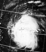
 Tropical cyclones impact the island chain with tropical storm-force winds once every three years, on average. The wettest known cyclone to affect the island group occurred early in 1966, when nearly 19 inches (482.6 mm) fell at Vaipito.
was the last tropical cyclone to enter the United States
from Mexico
at tropical storm strength. The rainfall which fell across the Mogollon Rim
led to the state's 24-hour rainfall record.

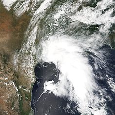
stalled for three days across southeast Texas which lead to prolonged rains across Arkansas. This way, Allison became the wettest known tropical cyclone to impact the state.
.jpg)
.
. Most recently, Javier
dropped locally heavy rainfall exceeding 4 inches (101.6 mm) over the higher terrain of western Colorado in 2004.

is also the wettest known for the state of Connecticut. The flood from Hurricane Diane
led to a significant death toll (nearly 200) from Pennsylvania eastward through southern New England.

 A large swath of heavy rainfall spread over the East coast along a frontal zone draping over the northern side of Hurricane Floyd
. Over 10 inches (254 mm) fell across portions of Delaware
, the most recorded during the passage of a tropical cyclone or its remnants within the state borders.
in 1950, which caused 38.7 inches (983 mm) of precipitation. This is also the highest known point storm total maximum related to any tropical cyclone which has impacted Florida, and by itself would be the highest known rainfall total for any month, or any 24 hour period, from any location within Florida. This rainfall amount remained the national 24-hour rainfall record until Tropical Storm Claudette
's landfall
in 1979.

looped across central Georgia, leading to 24-hour rainfall amounts exceeding 20 inches (508 mm) across central sections of the state. It also became the wettest tropical cyclone on record for the state of Georgia, eclipsing the record set in 1929.
.jpg)
 This island state frequently sees rainfall from the remains of former eastern and central Pacific tropical cyclones. However, despite Hawaii's location in the subtropics, direct impacts by tropical cyclones are infrequent due to the protective influence of the Central Pacific Tropical Upper Tropospheric Trough (TUTT), which normally dissipates systems approaching Hawaii. Hurricane Hiki in 1950 led to significant rainfall in the mountains, with 52 inches (1,320.8 mm) of rainfall reported. This is the most rainfall produced by a tropical cyclone on record within the United States.
are rare. Most recently, the remains of Olivia moved through the region in 1982, spurring spotty moderate to heavy rainfall across Idaho
.

directed moisture up to a front to its north across the Midwest during late June 1957 as it transitioned into an extratropical cyclone
. Heavy rains fell across central Illinois, leading to the wettest known event to be associated with a tropical cyclone or its remains across Illinois
.

directed moisture up to a front to its north across the Midwest during late June 1957 as it transitioned into an extratropical cyclone
. Heavy rains fell across central Indiana
, leading to the wettest known event to be associated with a tropical cyclone or its remains across the state.
was a large hurricane which moved into Texas during September 1961. As it transitioned into an extratropical cyclone
across the Great Plains
and Midwest, heavy rainfall fell in a band on the poleward side of a frontal boundary extending northeast from Carla, leading to the wettest known event to be associated with a tropical cyclone or its remains across Iowa
.

fell from the western Gulf coast northward into the Great Plains
. Heavy rainfall spread across portions of Kansas
, with localized amounts above 12 inches (304.8 mm) recorded.
system over Arkansas and Kentucky
. The maximum in Kentucky not only represents their highest tropical cyclone-related rainfall amount on record, but also the state's all-time 24 hour precipitation record (through 1998).

, Tropical Storm Frances (1998)
, Tropical Storm Allison (1989)
, and Tropical Storm Claudette (1979)
. Three of the four systems stalled across eastern Texas, prolonging the rainfall which occurred over Louisiana
. If it were not for the intermittent invasions from tropical cyclones, rainfall during the months of August, September, and October would average about 25% less than it currently does.
just one day before Daisy hit, and Hurricane Daisy, caused severe flooding in Maine
, when rain fell for 65 consecutive hours in some locations. Rainfall from the two systems caused record rainfall in some areas in Maine.
's remnants brought great moisture to the Northeast third of the United States in the combination of warm, tropical air and cold air from a cold front. From Virginia
through New Jersey
, 5 inches (127 mm) of rain were reported, while New York
and Pennsylvania
experienced 10 inches (254 mm). Westminster, Maryland
received the maximum amount from the storm in this region with a total of 14.23 inches (361.4 mm). The excessive rainfall across the Mid-Atlantic states led to overflown rivers from flash flooding.

is also the wettest known for the state of Massachusetts
. The flood from Hurricane Diane
led to a significant death toll (nearly 200) from Pennsylvania eastward through southern New England.

was a large hurricane which moved into Texas during September 1961. As it transitioned into an extratropical cyclone
across the Great Plains
and Midwest, heavy rainfall fell in a band on the poleward side of a frontal boundary extending northeast from Carla, leading to the wettest known event to be associated with a tropical cyclone or its remains across Michigan
.
.jpg)
. Most recently, 2004's Hurricane Javier
dropped locally heavy rainfall exceeding 2 inches (50.8 mm) in localized spots.

stalled over the southern portion of the state, it produced torrential rainfall, exceeding 30 inches (762 mm) locally. The heavy rainfall contributed to significant river overflowing, including the Tchoutacabouffa River at D'Iberville
, which set a record crest of 19 feet (5.8 m).
reintensified over Oklahoma
leading to heavy rainfall in that state. As the system moved eastward, its surface low quickly dissipated. However, its mid-level circulation remained robust, leading to a burst of heavy rainfall across Missouri
exceeding 10 inches (254 mm) in isolated spots, which became the wettest tropical cyclone remnant on record for the state.
. The remains of Kathleen
dropped locally heavy rainfall approaching 2 inches (50.8 mm) in localized spots.
was a large hurricane which moved into Texas during September 1961. As it transitioned into an extratropical cyclone
across the Great Plains
and Midwest, heavy rainfall fell in a band on the poleward side of a frontal boundary extending northeast from Carla, leading to the wettest known event to be associated with a tropical cyclone or its remains across Nebraska
.
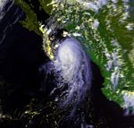
is impacted by eastern Pacific tropical cyclones, or their remnants, every few years. The wettest event for the state was during Hurricane Doreen, when over 4 inches (101.6 mm) fell in isolated spots.

. Nearly 10 inches (254 mm) fell across portions of New Hampshire, the most recorded during the passage of a tropical cyclone or its remnants.

, which produced over 14 inches (355.6 mm) across portions of New Jersey
.
from both the eastern Pacific and Atlantic basins. Although Atlantic Basin tropical cyclones are more unusual events, the rainfall record for New Mexico was from a tropical depression which moved across Texas from the Gulf of Mexico in October 1954.
frequently. During Hurricane Connie
, over 13 inches (330.2 mm) fell in isolated spots, which is the most rainfall recorded with a tropical cyclone or its remains across the state.
.jpg)
coastline, as well as inland from the western subtropical Atlantic ocean
. As much as 15% of the rainfall which occurs during the warm season in the Carolinas is attributable to tropical cyclones. Over the past 30 years, the wettest tropical cyclone to strike the coastal plain was Hurricane Floyd
of September 1999, which dropped over 24 inches (609.6 mm) of rainfall north of Southport
. In the mountains, Hurricane Frances
of September 2004 was nearly as wet, bringing over 23 inches (584.2 mm) of rainfall to Mount Mitchell
.
. The remains of Javier in 2004
dropped locally heavy rainfall exceeding 1 inches (25.4 mm) in localized spots.
 The Northern Marianas Islands are an archipelago north of Guam which gets impacted by typhoons in the western Pacific from time to time. Typhoon Steve dropped nearly 20 inches (508 mm) on Saipan in 1993, making it the wettest known tropical cyclone for the island chain.
can be impact by the remnants of both eastern Pacific and Atlantic tropical cyclones, with a bulk of the activity originating in the Gulf of Mexico
. Hurricane Frederic
in 1979, interacting with a nearby frontal zone, brought over 8 inches (203.2 mm) of rainfall to isolated spots of the state, becoming the wettest known tropical cyclone, or remnant, to impact Ohio.

reintensified over Oklahoma
leading to heavy rainfall within the state. Rainfall exceeded 12 inches (304.8 mm) in isolated spots, which turned out to be the third wettest tropical cyclone remnant on record for Oklahoma.
are rare. Most recently, the remains of Igancio moved through the region, spurring spotty moderate rainfall across the region.
.jpg)
was barely a hurricane at landfall in Florida
, its major impact was over the Mid-Atlantic region, where Agnes combined with a non-tropical low to produce widespread rains of 6 inches (152.4 mm) to 12 inches (304.8 mm) with local amounts up to 19 inches (482.6 mm) in western Schuylkill County
in Pennsylvania
. These rains produced widespread severe flooding from Virginia
northward to New York, with other flooding occurring over the western portions of the Carolinas.
has seen dramatic rainfall from tropical cyclones and their precursor disturbances. The most recent tropical cyclone-related deluge was from Hurricane Georges
from September 1998, when 30.51 inches (775 mm) of rain was measured at Jayuya. The heaviest rainfall noted over the past 30 years was from the precursor disturbance to Tropical Storm Isabel (1985)
, when 31.67 inches (804.4 mm) fell at Toro Negro Forest. Hurricane Eloise
of 1975 dropped 33.29 inches (845.6 mm) of rainfall at Dos Bocas, with 23.07 inches (586 mm) falling in 24 hours.
Below is a list of the top ten highest known storm total rainfall amounts from individual tropical cyclones across Puerto Rico since 1960. The rainfall information was gathered from the National Climatic Data Center
in Asheville, North Carolina
.

is also the wettest known for the state of Rhode Island
. The flood from Hurricane Diane
led to a significant death toll (nearly 200) from Pennsylvania eastward through southern New England.

experienced significant rainfall totals approaching 19 inches (482.6 mm) with Tropical Storm Jerry (1995)
, which became the wettest known tropical cyclone to impact the state. The flash flooding covered numerous roadways and washed out bridges, with the statewide transportation damage totaling $4.5 million (1995 USD). River flooding was great across the state. In addition, the rainfall broke dams, flooded houses, and covered fields, causing a damage total of $10.1 million (1995 USD).

. The remains of Javier in 2004
dropped locally heavy rainfall exceeding 2 inches (50.8 mm) in localized spots.
moved inland into the Southeast, producing a burst of rainfall across Tennessee exceeding 13 inches (330.2 mm). This system stands as Tennessee's wettest known tropical cyclone.
.jpg)
, also tend to make good rainmakers. Slow moving systems, such as Tropical Storm Amelia (1978)
also can produce significant rainfall over the Lone Star State. Amelia's storm total rainfall is the most recorded within the contiguous United States. Tropical Storm Claudette (1979)
holds the national 24-hour rainfall record for the United States, with 42 inches (1,066.8 mm) falling within a day.
 Tropical cyclones affect these islands of the northeast Caribbean on a regular basis. Hurricane Hortense
is the wettest known system for the U. S. Virgin Islands, bringing over 18 inches (457.2 mm) of rainfall.
is impacted by the remnants of eastern Pacific tropical cyclones. The remains of Olivia moved through the region in 1982, spurring spotty moderate to heavy rainfall exceeding 7 inches (177.8 mm) in isolated spots.
. Over 11 inches (279.4 mm) fell across portions of Vermont
, the most recorded during the passage of a tropical cyclone or its remnants within the state.

). As a tropical system approaches from the south, a frontal zone sets up between the moist Atlantic Ocean and the drier landmass to the west. This boundary can set up two or three days in advance of a tropical storm, and can lead up to prolonged heavy rains across coastal sections (e.g. Hurricane Floyd
. As the cyclone advances north, the boundary will slowly shift west, but progresses west of a Richmond
/Washington, D.C.
line.
are rare. The remains of Igancio moved through the region, spurring spotty moderate rainfall across the region.
was a large hurricane which moved into Texas during September 1961. As it transitioned into an extratropical cyclone
across the Great Plains
and Midwest, heavy rainfall fell in a band on the poleward side of a frontal boundary extending northeast from Carla, leading to the wettest known event to be associated with a tropical cyclone or its remains across Wisconsin
.
.jpg)
was barely a hurricane at landfall in Florida
, its major impact was over the Mid-Atlantic region, where Agnes combined with a non-tropical low to produce widespread heavy rainfall, including amounts approaching 8 inches (203.2 mm) in isolated spots of West Virginia
. These rains produced widespread severe flooding from Virginia
northward to New York, with other flooding occurring over the western portions of the Carolinas.
.jpg)
. Most recently, Hurricane Javier (2004)
dropped locally heavy rainfall of up to 2 inches (50.8 mm) in the higher terrain of western Wyoming.
Tropical cyclone
A tropical cyclone is a storm system characterized by a large low-pressure center and numerous thunderstorms that produce strong winds and heavy rain. Tropical cyclones strengthen when water evaporated from the ocean is released as the saturated air rises, resulting in condensation of water vapor...
s and their remnants. These storms have moved into the lower 48 United States
United States
The United States of America is a federal constitutional republic comprising fifty states and a federal district...
from the Atlantic Ocean
Atlantic Ocean
The Atlantic Ocean is the second-largest of the world's oceanic divisions. With a total area of about , it covers approximately 20% of the Earth's surface and about 26% of its water surface area...
, the Gulf of Mexico
Gulf of Mexico
The Gulf of Mexico is a partially landlocked ocean basin largely surrounded by the North American continent and the island of Cuba. It is bounded on the northeast, north and northwest by the Gulf Coast of the United States, on the southwest and south by Mexico, and on the southeast by Cuba. In...
, and the eastern Pacific Ocean
Pacific Ocean
The Pacific Ocean is the largest of the Earth's oceanic divisions. It extends from the Arctic in the north to the Southern Ocean in the south, bounded by Asia and Australia in the west, and the Americas in the east.At 165.2 million square kilometres in area, this largest division of the World...
. The tropical cyclones and their remnants which have brought rainfall to Alaska
Alaska
Alaska is the largest state in the United States by area. It is situated in the northwest extremity of the North American continent, with Canada to the east, the Arctic Ocean to the north, and the Pacific Ocean to the west and south, with Russia further west across the Bering Strait...
, Puerto Rico
Puerto Rico
Puerto Rico , officially the Commonwealth of Puerto Rico , is an unincorporated territory of the United States, located in the northeastern Caribbean, east of the Dominican Republic and west of both the United States Virgin Islands and the British Virgin Islands.Puerto Rico comprises an...
, the U.S. Virgin Islands, Hawaii
Hawaii
Hawaii is the newest of the 50 U.S. states , and is the only U.S. state made up entirely of islands. It is the northernmost island group in Polynesia, occupying most of an archipelago in the central Pacific Ocean, southwest of the continental United States, southeast of Japan, and northeast of...
, Guam
Guam
Guam is an organized, unincorporated territory of the United States located in the western Pacific Ocean. It is one of five U.S. territories with an established civilian government. Guam is listed as one of 16 Non-Self-Governing Territories by the Special Committee on Decolonization of the United...
, and American Samoa
American Samoa
American Samoa is an unincorporated territory of the United States located in the South Pacific Ocean, southeast of the sovereign state of Samoa...
are also included within this list. The highest totals have been measured across the Gulf coast and lower portions of the Eastern Seaboard. Intermediate amounts have been measured across the Southwest, New England, and the Midwest. The northern Great Plains
Great Plains
The Great Plains are a broad expanse of flat land, much of it covered in prairie, steppe and grassland, which lies west of the Mississippi River and east of the Rocky Mountains in the United States and Canada. This area covers parts of the U.S...
and Pacific Northwest have received the lowest amounts, as those regions lie exceptionally far from the breeding grounds of Atlantic and Eastern Pacific tropical cyclones.
Alabama
The wettest tropical cyclone to impact the state of AlabamaAlabama
Alabama is a state located in the southeastern region of the United States. It is bordered by Tennessee to the north, Georgia to the east, Florida and the Gulf of Mexico to the south, and Mississippi to the west. Alabama ranks 30th in total land area and ranks second in the size of its inland...
was Hurricane Danny
Hurricane Danny (1997)
Hurricane Danny was the only hurricane to make landfall in the United States during the 1997 Atlantic hurricane season, and the second hurricane and fourth tropical storm of the season...
, which stalled over Mobile Bay
Mobile Bay
Mobile Bay is an inlet of the Gulf of Mexico, lying within the state of Alabama in the United States. Its mouth is formed by the Fort Morgan Peninsula on the eastern side and Dauphin Island, a barrier island on the western side. The Mobile River and Tensaw River empty into the northern end of the...
for over 24 hours, and which led to significant rainfall.
| Wettest tropical cyclones, and their remnants, in Alabama Highest known recorded totals |
||||
|---|---|---|---|---|
| Precipitation | Storm | Measurement station |
||
| Rank | (mm Millimetre The millimetre is a unit of length in the metric system, equal to one thousandth of a metre, which is the SI base unit of length.... ) |
(in Inch An inch is the name of a unit of length in a number of different systems, including Imperial units, and United States customary units. There are 36 inches in a yard and 12 inches in a foot... ) |
||
| 1 | 958.9 mm | 37.75 inches | Danny 1997 Hurricane Danny (1997) Hurricane Danny was the only hurricane to make landfall in the United States during the 1997 Atlantic hurricane season, and the second hurricane and fourth tropical storm of the season... |
Dauphin Island Dauphin Island, Alabama Dauphin Island is a town in Mobile County, Alabama , on a barrier island also named Dauphin Island , at the Gulf of Mexico. The population was 1,371 at the 2000 census. The town is included in the Mobile metropolitan statistical area... Sea Lab |
| 2 | 753.4 mm | 29.66 inches | Georges 1998 Hurricane Georges Hurricane Georges was a very destructive, powerful and long-lived Cape Verde-type Category 4 hurricane. Georges was the seventh tropical storm, fourth hurricane, and second major hurricane of the 1998 Atlantic hurricane season... |
Bay Minette Bay Minette, Alabama Bay Minette is a city in Baldwin County, Alabama, United States. As of the 2000 census, the population of the city was 7,820. According to the 2007 U.S. Census estimates, the city had an population of about 7,726 people. The city is the county seat of Baldwin County... |
| 3 | 574.8 mm | 22.63 inches | Alberto 1994 Tropical Storm Alberto (1994) Tropical Storm Alberto was the first storm of the 1994 Atlantic hurricane season. It hit Florida across the Southeast United States in July, causing a massive flooding disaster while stalling over Georgia and Alabama. Alberto caused $1 billion in damage and 30 deaths.-Meteorological history:A... |
Enterprise Enterprise, Alabama Enterprise is a city in the southeastern part of Coffee and Dale Counties in the southeastern part of Alabama in the Southern United States. The population was estimated to be 25,909 in the year 2009.... 5 NNW |
| 4 | 493.3 mm | 19.42 inches | Opal 1995 Hurricane Opal Hurricane Opal was a Category 4 hurricane that formed in the Gulf of Mexico in September 1995.Opal was the ninth hurricane and the strongest of the abnormally active 1995 Atlantic hurricane season... |
Brewton Brewton, Alabama Brewton is a city in Escambia County, Alabama, United States. At the 2000 census the population was 5,498. The city is the county seat of Escambia County.-History:... 3 ENE |
| 5 | 428.0 mm | 16.85 inches | Debbie 1965 | Mobile Mobile, Alabama Mobile is the third most populous city in the Southern US state of Alabama and is the county seat of Mobile County. It is located on the Mobile River and the central Gulf Coast of the United States. The population within the city limits was 195,111 during the 2010 census. It is the largest... |
| 6 | 420.6 mm | 16.56 inches | Unnamed 1987 Unnamed Tropical Storm (1987) The 1987 Gulf Coast tropical storm was the first tropical storm of the below-average 1987 Atlantic hurricane season. Originating from a tropical wave, the system was first classified as a tropical depression over the Gulf of Mexico, southeast of Texas, on August 9... |
Brewton Brewton, Alabama Brewton is a city in Escambia County, Alabama, United States. At the 2000 census the population was 5,498. The city is the county seat of Escambia County.-History:... 3 SSE |
| 7 | 408.7 mm | 16.09 inches | Beryl 1988 Tropical Storm Beryl (1988) Tropical Storm Beryl was an unusual Atlantic tropical cyclone that formed over southeastern Louisiana in August 1988. The second tropical storm of the 1988 Atlantic hurricane season, Beryl developed from a slow-moving trough of low pressure on August 8... |
Dauphin Island Dauphin Island, Alabama Dauphin Island is a town in Mobile County, Alabama , on a barrier island also named Dauphin Island , at the Gulf of Mexico. The population was 1,371 at the 2000 census. The town is included in the Mobile metropolitan statistical area... #2 |
| 8 | 335.3 mm | 13.20 inches | Carmen 1974 Hurricane Carmen Hurricane Carmen was the most intense tropical cyclone of the 1974 Atlantic hurricane season. A destructive and widespread storm, Carmen originated as a tropical disturbance that emerged from Africa toward the end of August. The wave traveled westward, spawning a tropical depression east of the... |
Atmore Atmore, Alabama Atmore is a city in Escambia County, Alabama, United States. At the 2000 census the population was 7,676. According to the 2005 U.S. Census estimates, the city had a population of 7,530. The city was named for Mr. C.P. Atmore.... |
| 9 | 328.6 mm | 12.94 inches | Lee 2011 Tropical Storm Lee (2011) Tropical Storm Lee was the twelfth named storm and thirteenth system overall of the 2011 Atlantic hurricane season, developing from a broad tropical disturbance over the Gulf on September 1. It was designated as Tropical Storm Lee the next day... |
Fyffe 6.3 NNE |
| 10 | 325.1 mm | 12.80 inches | Dennis 2005 Hurricane Dennis Hurricane Dennis was an early-forming major hurricane in the Caribbean and Gulf of Mexico during the very active 2005 Atlantic hurricane season. Dennis was the fourth named storm, second hurricane, and first major hurricane of the season... |
Camden Camden, Alabama Camden is a city in Wilcox County, Alabama, United States. The population was 2,257 at the 2000 census, at which time it was a town.-Geography:Camden is located at .... 10 NW |
Alaska
While no tropical cyclone has managed to track into Alaska, their remnants evolve into extratropical cyclones which bring rain to the state. The extratropical remains of Hurricane IokeHurricane Ioke
Hurricane Ioke was the strongest hurricane ever recorded in the Central Pacific...
brought a record daily rainfall of 1.15 inches (29.2 mm) to Bethel
Bethel, Alaska
Bethel is a city located near the west coast of the U.S. state of Alaska, west of Anchorage. Accessible only by air and river, Bethel is the main port on the Kuskokwim River and is an administrative and transportation hub for the 56 villages in the Yukon-Kuskokwim Delta.Bethel is the largest...
during September 2006. Rainfall is also documented to have fallen from the remains of Hurricane Fico
Hurricane Fico
Hurricane Fico was the longest-lived hurricane of the 1978 Pacific hurricane season and at the time was the longest-lasting Pacific hurricane on record, the record being held today by Hurricane John of 1994. The sixth tropical storm, fourth hurricane, and third major hurricane, Fico developed from...
in 1978.
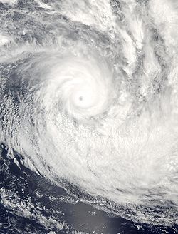
American Samoa
| Wettest tropical cyclones, and their remnants, in American Samoa Highest known recorded totals |
||||
|---|---|---|---|---|
| Precipitation | Storm | Measurement station |
||
| Rank | (mm Millimetre The millimetre is a unit of length in the metric system, equal to one thousandth of a metre, which is the SI base unit of length.... ) |
(in Inch An inch is the name of a unit of length in a number of different systems, including Imperial units, and United States customary units. There are 36 inches in a yard and 12 inches in a foot... ) |
||
| 1 | 472.4 mm | 18.60 inches | Samoa T.C. – Jan.-Feb. 1966 | Vaipito |
| 2 | 445.5 mm | 17.54 inches | Val 1991 | Pago Pago Airport |
| 3 | 394.7 mm | 15.54 inches | Ofa 1990 | Aasufou |
| 4 | 359.9 mm | 14.17 inches | Heta 2004 | Aasufou |
| 5 | 254.5 mm | 10.02 inches | Olaf 2005 Cyclone Olaf Cyclone Olaf was the sixth cyclone to form in the Southwest Pacific Ocean during the 2004-05 South Pacific cyclone season. Olaf was also one of three simultaneous cyclones to form during the 2004-05 season, forming 21 hours after Cyclone Nancy formed to the east. A powerful Category 5 cyclone,... |
Aasufou |
| 6 | 212.1 mm | 8.35 inches | Esau 1981 | Aasufou |
| 7 | 118.0 mm | 4.66 inches | Nisha 2010 | NWS Pago Pago |
| 8 | 95.5 mm | 3.76 inches | Keli 1997 Cyclone Keli Severe Tropical Cyclone Keli was the first recorded post-season tropical cyclone to form in June within the South Pacific Ocean. The system formed on June 7, 1997, about 460 kilometers to the north of Tokelau. The depression gradually developed over the next few days while moving southwestward... |
Afono |
| 9 | 80.5 mm | 3.17 inches | Tusi 1987 | Afono |
| 10 | 56.1 mm | 2.21 inches | Cilla 2003 | Aasufou |
Arizona
Hurricane NoraHurricane Nora (1997)
Hurricane Nora was only the third tropical cyclone on record to reach Arizona as a tropical storm. Nora was the fourteenth named tropical cyclone and seventh hurricane of the 1997 Pacific hurricane season...
was the last tropical cyclone to enter the United States
United States
The United States of America is a federal constitutional republic comprising fifty states and a federal district...
from Mexico
Mexico
The United Mexican States , commonly known as Mexico , is a federal constitutional republic in North America. It is bordered on the north by the United States; on the south and west by the Pacific Ocean; on the southeast by Guatemala, Belize, and the Caribbean Sea; and on the east by the Gulf of...
at tropical storm strength. The rainfall which fell across the Mogollon Rim
Mogollon Rim
The Mogollon Rim is a topographical and geological feature running across the U.S. state of Arizona. It extends approximately from northern Yavapai County eastward to near the border with New Mexico.-Description:...
led to the state's 24-hour rainfall record.
| Wettest tropical cyclones, and their remnants, in Arizona Highest known recorded totals |
||||
|---|---|---|---|---|
| Precipitation | Storm | Measurement station |
||
| Rank | (mm Millimetre The millimetre is a unit of length in the metric system, equal to one thousandth of a metre, which is the SI base unit of length.... ) |
(in Inch An inch is the name of a unit of length in a number of different systems, including Imperial units, and United States customary units. There are 36 inches in a yard and 12 inches in a foot... ) |
||
| 1 | 305.1 mm | 12.01 inches | Nora 1997 Hurricane Nora (1997) Hurricane Nora was only the third tropical cyclone on record to reach Arizona as a tropical storm. Nora was the fourteenth named tropical cyclone and seventh hurricane of the 1997 Pacific hurricane season... |
Harquahala Mountain |
| 2 | 304.8 mm | 12.00 inches | Octave 1983 | Mount Graham |
| 3 | 210.8 mm | 8.30 inches | Heather 1977 | Nogales Nogales, Arizona Nogales is a city in Santa Cruz County, Arizona, United States. The population was 21,017 at the 2010 census. According to 2005 Census Bureau estimates, the population of the city is 20,833. The city is the county seat of Santa Cruz County.... |
| 4 | 178.1 mm | 7.01 inches | Doreen 1977 | Yuma Valley |
| 5 | 177.8 mm | 7.00 inches | Javier 2004 Hurricane Javier (2004) Hurricane Javier was the tenth named storm and the sixth and final hurricane of the 2004 Pacific hurricane season. Javier was also the strongest hurricane of the 2004 season, with 150 mph winds and a central pressure of 930 millibars... |
Walnut Creek |
| 6 | 133.9 mm | 5.27 inches | Lester 1992 Hurricane Lester (1992) Hurricane Lester was the first Pacific tropical cyclone to enter the United States as a tropical storm since 1967. The twelfth named storm and seventh hurricane of the 1992 Pacific hurricane season, Lester formed on August 20 from a tropical wave southwest of Mexico. The tropical storm moved... |
Irving |
| 7 | 96.0 mm | 3.78 inches | Raymond 1989 Hurricane Raymond (1989) Hurricane Raymond was the strongest tropical cyclone of the 1989 Pacific hurricane season, peaking as a strong Category 4 hurricane on the Saffir-Simpson Hurricane Scale. Forming out of a tropical wave on September 25, the tropical depression slowly tracked northwest before becoming nearly... |
Santa Rita Experiment Range |
| 8 | 83.3 mm | 3.28 inches | Boris 1990 | Santa Rita Experiment Range |
| 9 | 72.9 mm | 2.87 inches | Kathleen 1976 Hurricane Kathleen (1976) Hurricane Kathleen was a hurricane of the 1976 Pacific hurricane season that caused destructive impacts in California. Kathleen caused widespread flooding and damage in northern Mexico and parts of the southwestern United States. It also took an unusual path. On September 7, a tropical depression... |
Davis Dam #2 |
| 10 | 71.9 mm | 2.83 inches | Marty 2003 Hurricane Marty (2003) Hurricane Marty was the deadliest tropical cyclone of the 2003 Pacific hurricane season. Forming on September 18, it became the 13th tropical storm and fourth hurricane of the year... |
Organ Pipe Cactus National Monument Organ Pipe Cactus National Monument Organ Pipe Cactus National Monument is a U.S. National Monument and UNESCO biosphere reserve located in extreme southern Arizona which shares a border with the Mexican state of Sonora. The park is the only place in the United States where the Organ Pipe Cactus grows wild... |
Arkansas
Tropical Storm Allison in 1989Tropical Storm Allison (1989)
Tropical Storm Allison was a tropical cyclone that produced severe flooding in the southern United States. The second tropical cyclone and the first named storm of the 1989 Atlantic hurricane season, Allison formed on June 24 in the northwestern Gulf of Mexico. Development of Allison was a result...
stalled for three days across southeast Texas which lead to prolonged rains across Arkansas. This way, Allison became the wettest known tropical cyclone to impact the state.
| Wettest tropical cyclones, and their remnants, in Arkansas Highest known recorded totals |
||||
|---|---|---|---|---|
| Precipitation | Storm | Measurement station |
||
| Rank | (mm Millimetre The millimetre is a unit of length in the metric system, equal to one thousandth of a metre, which is the SI base unit of length.... ) |
(in Inch An inch is the name of a unit of length in a number of different systems, including Imperial units, and United States customary units. There are 36 inches in a yard and 12 inches in a foot... ) |
||
| 1 | 353.3 mm | 13.91 inches | Allison 1989 Tropical Storm Allison (1989) Tropical Storm Allison was a tropical cyclone that produced severe flooding in the southern United States. The second tropical cyclone and the first named storm of the 1989 Atlantic hurricane season, Allison formed on June 24 in the northwestern Gulf of Mexico. Development of Allison was a result... |
Portland Portland, Arkansas Portland is a city in Ashley County, Arkansas, United States. The population was 552 at the 2000 census.-Geography:Portland is located at .According to the United States Census Bureau, the city has a total area of , all of it land.... |
| 2 | 349.8 mm | 13.77 inches | Bertha 1957 | Damascus 2 NNE Damascus, Arkansas Damascus is a town in Faulkner and Van Buren counties in the central part of the U.S. state of Arkansas. Its portion within Faulkner County is part of the Little Rock–North Little Rock–Conway Metropolitan Statistical Area... |
| 3 | 298.5 mm | 11.75 inches | Bonnie 1986 Hurricane Bonnie (1986) Hurricane Bonnie was the second named storm, and first hurricane of the 1986 Atlantic hurricane season. Forming on June 23, Bonnie developed out of an area of low pressure over the central Gulf of Mexico. The system gradually intensified and was declared Tropical Storm Bonnie the next day as... |
El Dorado Regional AP El Dorado, Arkansas El Dorado , a multi-cultural arts center: South Arkansas Arts Center , an award-winning renovated downtown, and numerous sporting, shopping, and dining opportunities. El Dorado is the population, cultural, and business center of the 7,300 mi² regional area... |
| 4 | 298.2 mm | 11.74 inches | Gustav 2008 Hurricane Gustav The name Gustav has been used for five tropical cyclones in the Atlantic Ocean:* 1984's Tropical Storm Gustav - Spent most of its existence as a tropical depression hovering over Bermuda, no major damage was reported.... |
Eudora/Bayou Macon |
| 5 | 283.5 mm | 11.16 inches | Unnamed 1960 | Clarendon Clarendon, Arkansas Clarendon is a city in Monroe County, Arkansas, United States. The population was 1,960 at the 2000 census. The city is the county seat of Monroe County.-Geography:Clarendon is located at .... |
| 6 | 265.4 mm | 10.45 inches | Frances 1998 Tropical Storm Frances (1998) Originating over the southwest Caribbean sea on September 4, Tropical Storm Frances became the sixth tropical storm of the 1998 Atlantic hurricane season. The cyclone moved northward through the western Gulf of Mexico, making landfall across the central Texas coastline before recurving across the... |
Sparkman Sparkman, Arkansas Sparkman is a city in Dallas County, Arkansas, United States. The population was 586 at the 2000 census.-Geography:Sparkman is located at .According to the United States Census Bureau, the city has a total area of , all of it land.... |
| 7 | 246.9 mm | 9.72 inches | Delia 1973 | Jessieville |
| 8 | 236.7 mm | 9.32 inches | Elena 1985 Hurricane Elena Hurricane Elena was a category 3 major hurricane that produced heavy damage along the Gulf Coast of the United States in August and September of the 1985 Atlantic hurricane season. The fifth tropical storm, fourth hurricane, and first major hurricane of the season, Elena developed near Cuba from a... |
Mountain Home Mountain Home, Arkansas Mountain Home is a city in and the county seat of Baxter County, Arkansas, United States, in the southern Ozark Mountains.It was recently listed in the top 20 cities in the U.S. for sportsmen in the current edition of Outdoor Life magazine, was recently ranked #2 for Field and Stream's Best Fishing... |
| 9 | 210.6 mm | 8.29 inches | Matthew 2004 Tropical Storm Matthew (2004) Tropical Storm Matthew was a weak tropical storm in the 2004 Atlantic hurricane season that made landfall on Louisiana. Matthew was the thirteenth tropical storm of the season and the ninth storm to affect the United States. Matthew formed over the western Gulf of Mexico on October 8 and struck... |
Mountain Pine 2NNW and Deer |
| 10 | 203.7 mm | 8.02 inches | Betsy 1965 Hurricane Betsy Hurricane Betsy was a Category 4 hurricane of the 1965 Atlantic hurricane season which caused enormous damage in the Bahamas, Florida, and Louisiana. Betsy made its most intense landfall near the mouth of the Mississippi River, causing significant flooding of the waters of Lake Pontchartrain into... |
Wynne Wynne, Arkansas Wynne is the county seat and largest city of Cross County, Arkansas, United States. The population was 8,615 at the 2000 Census. Nestled between the Arkansas Delta and Crowley's Ridge, Wynne is home to the largest state park in Arkansas, Village Creek State Park.-Geography:Wynne lies at , the... |
California
One of five known eastern Pacific tropical cyclones to bring tropical storm-force winds to the Southwest, Hurricane Kathleen accelerated northward ahead of an upper level trough, spreading heavy rains into the transverse ranges of southern CaliforniaCalifornia
California is a state located on the West Coast of the United States. It is by far the most populous U.S. state, and the third-largest by land area...
.
| Wettest tropical cyclones, and their remnants, in California Highest known recorded totals |
||||
|---|---|---|---|---|
| Precipitation | Storm | Measurement station |
||
| Rank | (mm Millimetre The millimetre is a unit of length in the metric system, equal to one thousandth of a metre, which is the SI base unit of length.... ) |
(in Inch An inch is the name of a unit of length in a number of different systems, including Imperial units, and United States customary units. There are 36 inches in a yard and 12 inches in a foot... ) |
||
| 1 | 374.9 mm | 14.76 inches | Kathleen 1976 Hurricane Kathleen (1976) Hurricane Kathleen was a hurricane of the 1976 Pacific hurricane season that caused destructive impacts in California. Kathleen caused widespread flooding and damage in northern Mexico and parts of the southwestern United States. It also took an unusual path. On September 7, a tropical depression... |
San Gorgonio |
| 2 | 294.6 mm | 11.60 inches | "Unnamed 1939 1939 Long Beach Tropical Storm The 1939 California tropical storm, also called the 1939 Long Beach Tropical Storm, El Cordonazo, The Lash of St. Francis was a tropical cyclone that hit Southern California in September, 1939. Formerly a hurricane, it was the only tropical storm to make landfall in California in the twentieth... " |
Mount Wilson Mount Wilson (California) Mount Wilson is one of the better known peaks in the San Gabriel Mountains, part of the Angeles National Forest in Los Angeles County, California. It is the location of the Mount Wilson Observatory and has become the astronomical center of Southern California with and telescopes, and and tall... |
| 3 | 189.2 mm | 7.45 inches | Doreen 1977 | Mount San Jacinto |
| 4 | 182.6 mm | 7.19 inches | Olivia 1982 | Grant Grove |
| 5 | 178.1 mm | 7.01 inches | Norman 1978 | Lodgepole |
| 6 | 88.1 mm | 3.47 inches | Nora 1997 Hurricane Nora (1997) Hurricane Nora was only the third tropical cyclone on record to reach Arizona as a tropical storm. Nora was the fourteenth named tropical cyclone and seventh hurricane of the 1997 Pacific hurricane season... |
Beaumont 1 E Beaumont, California Beaumont is a city in Riverside County, California, United States in the Greater Los Angeles area.Now a growing, community planned city, the population was 36,877 at the 2010 census, and expected to be up to 125,000 projected by 2040, making Beaumont as California's next, newest fastest-growing... |
| 7 | 76.5 mm | 3.01 inches | Isis 1998 Hurricane Isis (1998) Hurricane Isis was the deadliest tropical cyclone and only hurricane to make landfall during the 1998 Pacific hurricane season. The ninth tropical storm and sixth hurricane of the season, Isis developed on September 1 from the interaction between a tropical wave and a large surface circulation to... |
Balch Power House |
| 8 | 55.1 mm | 2.17 inches | Ignacio 1997 | Three Peaks |
| 9 | 42.2 mm | 1.66 inches | Lester 1992 Hurricane Lester (1992) Hurricane Lester was the first Pacific tropical cyclone to enter the United States as a tropical storm since 1967. The twelfth named storm and seventh hurricane of the 1992 Pacific hurricane season, Lester formed on August 20 from a tropical wave southwest of Mexico. The tropical storm moved... |
Parker Reservoir |
| 10 | 34.3 mm | 1.35 inches | Boris 1990 | Boulevard 2 |
Colorado
Few tropical cyclone remnants originating from the eastern Pacific make it as far north as ColoradoColorado
Colorado is a U.S. state that encompasses much of the Rocky Mountains as well as the northeastern portion of the Colorado Plateau and the western edge of the Great Plains...
. Most recently, Javier
Hurricane Javier (2004)
Hurricane Javier was the tenth named storm and the sixth and final hurricane of the 2004 Pacific hurricane season. Javier was also the strongest hurricane of the 2004 season, with 150 mph winds and a central pressure of 930 millibars...
dropped locally heavy rainfall exceeding 4 inches (101.6 mm) over the higher terrain of western Colorado in 2004.
| Wettest tropical cyclone remnants to affect Colorado Highest known recorded totals |
||||
|---|---|---|---|---|
| Precipitation | Storm | Measurement station |
||
| Rank | (mm Millimetre The millimetre is a unit of length in the metric system, equal to one thousandth of a metre, which is the SI base unit of length.... ) |
(in Inch An inch is the name of a unit of length in a number of different systems, including Imperial units, and United States customary units. There are 36 inches in a yard and 12 inches in a foot... ) |
||
| 1 | 135.9 mm | 5.35 inches | Lester 1992 Hurricane Lester (1992) Hurricane Lester was the first Pacific tropical cyclone to enter the United States as a tropical storm since 1967. The twelfth named storm and seventh hurricane of the 1992 Pacific hurricane season, Lester formed on August 20 from a tropical wave southwest of Mexico. The tropical storm moved... |
Wolf Creek Pass 1 E |
| 2 | 109.2 mm | 4.30 inches | Javier 2004 Hurricane Javier (2004) Hurricane Javier was the tenth named storm and the sixth and final hurricane of the 2004 Pacific hurricane season. Javier was also the strongest hurricane of the 2004 season, with 150 mph winds and a central pressure of 930 millibars... |
Beartown |
| 3 | 48.3 mm | 1.90 inches | Dolly 2008 Hurricane Dolly (2008) Hurricane Dolly was a tropical cyclone that made landfall in extreme southern Texas in July 2008. Dolly was the fourth tropical cyclone and second hurricane to form during the 2008 Atlantic hurricane season. It was the first U.S. landfalling hurricane of the 2008 season. Dolly developed on July 20... |
Her |
Connecticut
The wettest known tropical cyclone to impact New EnglandNew England
New England is a region in the northeastern corner of the United States consisting of the six states of Maine, New Hampshire, Vermont, Massachusetts, Rhode Island, and Connecticut...
is also the wettest known for the state of Connecticut. The flood from Hurricane Diane
Hurricane Diane
Hurricane Diane was one of three hurricanes to hit North Carolina during the 1955 Atlantic hurricane season, striking an area that had been hit by Hurricane Connie five days earlier...
led to a significant death toll (nearly 200) from Pennsylvania eastward through southern New England.
| Wettest tropical cyclones, and their remnants, in Connecticut Highest known recorded totals |
||||
|---|---|---|---|---|
| Precipitation | Storm | Measurement station |
||
| Rank | (mm Millimetre The millimetre is a unit of length in the metric system, equal to one thousandth of a metre, which is the SI base unit of length.... ) |
(in Inch An inch is the name of a unit of length in a number of different systems, including Imperial units, and United States customary units. There are 36 inches in a yard and 12 inches in a foot... ) |
||
| 1 | 428.2 mm | 16.86 inches | Diane 1955 Hurricane Diane Hurricane Diane was one of three hurricanes to hit North Carolina during the 1955 Atlantic hurricane season, striking an area that had been hit by Hurricane Connie five days earlier... |
Torrington #2 |
| 2 | 338.3 mm | 13.32 inches | Eloise 1975 Hurricane Eloise Hurricane Eloise was the most destructive tropical cyclone of the 1975 Atlantic hurricane season. The fifth tropical storm, fourth hurricane, and second major hurricane of the season, Eloise formed as a tropical depression on September 13 to the east of the Virgin Islands... |
Mount Carmel |
| 3 | 289.6 mm | 11.40 inches | Floyd 1999 Hurricane Floyd Hurricane Floyd was the sixth named storm, fourth hurricane, and third major hurricane in the 1999 Atlantic hurricane season. Floyd triggered the third largest evacuation in US history when 2.6 million coastal residents of five states were ordered from their homes as it approached... |
West Hartford |
| 4 | 257.8 mm | 10.15 inches | Irene 2011 Hurricane Irene (2011) Hurricane Irene was a large and powerful Atlantic hurricane that left extensive flood and wind damage along its path through the Caribbean, the United States East Coast and as far north as Atlantic Canada in 2011... |
New Hartford |
| 5 | 240.8 mm | 9.48 inches | Connie 1955 Hurricane Connie Hurricane Connie was the first in a series of hurricanes to strike North Carolina during the 1955 Atlantic hurricane season. Connie struck as a Category 1, causing major flooding and inflicting extensive damage to the Outer Banks and inland to Raleigh.... |
Round Pond |
| 6 | 185.9 mm | 7.34 inches | Donna 1960 Hurricane Donna Hurricane Donna in the 1960 Atlantic hurricane season was a Cape Verde-type hurricane which moved across the Leeward Islands, Puerto Rico, Hispanola, Cuba, The Bahamas, and every state on the East Coast of the United States... |
Wolcott Reservoir |
| 7 | 162.3 mm | 6.39 inches | Lee 2011 Tropical Storm Lee (2011) Tropical Storm Lee was the twelfth named storm and thirteenth system overall of the 2011 Atlantic hurricane season, developing from a broad tropical disturbance over the Gulf on September 1. It was designated as Tropical Storm Lee the next day... |
Danbury Danbury, Connecticut Danbury is a city in northern Fairfield County, Connecticut, United States. It had population at the 2010 census of 80,893. Danbury is the fourth largest city in Fairfield County and is the seventh largest city in Connecticut.... |
| 8 | 158.0 mm | 6.22 inches | Bob 1991 Hurricane Bob Hurricane Bob was one of the costliest hurricanes in New England history. The second named storm and first hurricane of the 1991 Atlantic hurricane season, Bob developed from an area of low pressure near The Bahamas on August 16. The depression steadily intensified, and became Tropical Storm Bob... |
Norwich Public Utility Plant |
| 9 | 136.9 mm | 5.39 inches | Beryl 1994 Tropical Storm Beryl (1994) Tropical Storm Beryl, was the second named storm of the 1994 Atlantic hurricane season. Beryl originated north of Puerto Rico as an upper-level low pressure system, then passed over Florida, then entered the gulf where it became a tropical depression. The storm had advisories on it for five days;... |
West Hartford West Hartford, Connecticut West Hartford is a town located in Hartford County, Connecticut, United States. The town was incorporated in 1854. Prior to that date, the town was a parish of Hartford.... |
| 10 | 132.6 mm | 5.22 inches | Allison 2001 Tropical Storm Allison Tropical Storm Allison was a tropical storm that devastated southeast Texas in June of the 2001 Atlantic hurricane season. The first storm of the season, Allison lasted an unusually long period of time for a June storm, remaining tropical or subtropical for 15 days... |
Round Pond |
Delaware
Hurricane Floyd
Hurricane Floyd was the sixth named storm, fourth hurricane, and third major hurricane in the 1999 Atlantic hurricane season. Floyd triggered the third largest evacuation in US history when 2.6 million coastal residents of five states were ordered from their homes as it approached...
. Over 10 inches (254 mm) fell across portions of Delaware
Delaware
Delaware is a U.S. state located on the Atlantic Coast in the Mid-Atlantic region of the United States. It is bordered to the south and west by Maryland, and to the north by Pennsylvania...
, the most recorded during the passage of a tropical cyclone or its remnants within the state borders.
| Wettest tropical cyclones, and their remnants, in Delaware Highest known recorded totals |
||||
|---|---|---|---|---|
| Precipitation | Storm | Measurement station |
||
| Rank | (mm Millimetre The millimetre is a unit of length in the metric system, equal to one thousandth of a metre, which is the SI base unit of length.... ) |
(in Inch An inch is the name of a unit of length in a number of different systems, including Imperial units, and United States customary units. There are 36 inches in a yard and 12 inches in a foot... ) |
||
| 1 | 268.7 mm | 10.58 inches | Floyd 1999 Hurricane Floyd Hurricane Floyd was the sixth named storm, fourth hurricane, and third major hurricane in the 1999 Atlantic hurricane season. Floyd triggered the third largest evacuation in US history when 2.6 million coastal residents of five states were ordered from their homes as it approached... |
Greenwood 2 NE Greenwood, Delaware As of the census of 2000, there were 837 people, 335 households, and 211 families residing in the town. The population density was 1,267.2 people per square mile . There were 394 housing units at an average density of 596.5 per square mile... |
| 2 | 264.9 mm | 10.43 inches | Irene 2011 Hurricane Irene (2011) Hurricane Irene was a large and powerful Atlantic hurricane that left extensive flood and wind damage along its path through the Caribbean, the United States East Coast and as far north as Atlantic Canada in 2011... |
Ellendale |
| 3 | 207.8 mm | 8.18 inches | Connie 1955 Hurricane Connie Hurricane Connie was the first in a series of hurricanes to strike North Carolina during the 1955 Atlantic hurricane season. Connie struck as a Category 1, causing major flooding and inflicting extensive damage to the Outer Banks and inland to Raleigh.... |
Newark University Farm |
| 4 | 195.6 mm | 7.70 inches | Donna 1960 Hurricane Donna Hurricane Donna in the 1960 Atlantic hurricane season was a Cape Verde-type hurricane which moved across the Leeward Islands, Puerto Rico, Hispanola, Cuba, The Bahamas, and every state on the East Coast of the United States... |
Bridgeville 1 NW Bridgeville, Delaware As of the census of 2000, there were 1,436 people, 570 households, and 381 families residing in the town. The population density was 1,768.6 people per square mile . There were 636 housing units at an average density of 783.3 per square mile... |
| 5 | 193.0 mm | 7.60 inches | Agnes 1972 Hurricane Agnes Hurricane Agnes was the first tropical storm and first hurricane of the 1972 Atlantic hurricane season. A rare June hurricane, it made landfall on the Florida Panhandle before moving northeastward and ravaging the Mid-Atlantic region as a tropical storm... |
Middletown 3 E Middletown, Delaware Middletown is a town in New Castle County, Delaware, United States. According to the 2010 Census, the population of the town is 18,871.-Geography:Middletown is located at with an elevation of .... |
| 6 | 181.1 mm | 7.13 inches | Danny 1985 Hurricane Danny (1985) Hurricane Danny was a minimal Category 1 hurricane on the Saffir-Simpson hurricane scale that made landfall in the U.S. state of Louisiana. The fourth tropical cyclone and third hurricane of the 1985 Atlantic hurricane season, Danny originated from a tropical wave that moved into the western... |
Lewes Lewes, Delaware Lewes is an incorporated city in Sussex County, Delaware, USA, on the Delmarva Peninsula. According to the 2010 census, the population is 2,747, a decrease of 6.3% from 2000.... |
| 7 | 175.3 mm | 6.90 inches | Chesapeake-Potomac 1933 1933 Chesapeake Potomac Hurricane The 1933 Chesapeake-Potomac Hurricane was the eighth storm and third hurricane of the very active 1933 Atlantic hurricane season. The August storm formed in the central Atlantic, where it moved west-northwest... |
Bridgeville 1 NW Bridgeville, Delaware As of the census of 2000, there were 1,436 people, 570 households, and 381 families residing in the town. The population density was 1,768.6 people per square mile . There were 636 housing units at an average density of 783.3 per square mile... |
| 8 | 174.5 mm | 6.87 inches | Allison 1989 Tropical Storm Allison (1989) Tropical Storm Allison was a tropical cyclone that produced severe flooding in the southern United States. The second tropical cyclone and the first named storm of the 1989 Atlantic hurricane season, Allison formed on June 24 in the northwestern Gulf of Mexico. Development of Allison was a result... |
Wilmington New Castle Wilmington, Delaware Wilmington is the largest city in the state of Delaware, United States, and is located at the confluence of the Christina River and Brandywine Creek, near where the Christina flows into the Delaware River. It is the county seat of New Castle County and one of the major cities in the Delaware Valley... |
| 9 | 158.0 mm | 6.22 inches | Great Atlantic 1944 1944 Great Atlantic Hurricane The Great Atlantic Hurricane in 1944 was an intense Atlantic hurricane sometimes compared to the New England Hurricane of 1938.-Meteorological history:... |
Millsboro Millsboro, Delaware As of the census of 2000, there were 2,360 people, 1,045 households, and 619 families residing in the town. The population density was 1,367.9 people per square mile . There were 1,153 housing units at an average density of 668.3 per square mile... |
| 10 | 150.4 mm | 5.92 inches | Eloise 1975 Hurricane Eloise Hurricane Eloise was the most destructive tropical cyclone of the 1975 Atlantic hurricane season. The fifth tropical storm, fourth hurricane, and second major hurricane of the season, Eloise formed as a tropical depression on September 13 to the east of the Virgin Islands... |
Middletown 3 E Middletown, Delaware Middletown is a town in New Castle County, Delaware, United States. According to the 2010 Census, the population of the town is 18,871.-Geography:Middletown is located at with an elevation of .... |
Florida
The heaviest rainfall to occur in 24 hours was measured in Yankeetown during Hurricane EasyHurricane Easy (1950)
Hurricane Easy was the fifth tropical storm, hurricane, and major hurricane of the 1950 Atlantic hurricane season. The hurricane developed in the western Caribbean Sea on September 1, and tracked northeastward. After crossing Cuba, the hurricane rapidly strengthened in the eastern Gulf of Mexico to...
in 1950, which caused 38.7 inches (983 mm) of precipitation. This is also the highest known point storm total maximum related to any tropical cyclone which has impacted Florida, and by itself would be the highest known rainfall total for any month, or any 24 hour period, from any location within Florida. This rainfall amount remained the national 24-hour rainfall record until Tropical Storm Claudette
Tropical Storm Claudette (1979)
Tropical Storm Claudette was a long living tropical storm that produced heavy rain across Puerto Rico and Texas in late July 1979. The storm killed 2 people and left $1.1 billion in damage...
's landfall
Landfall (meteorology)
Landfall is the event of a tropical cyclone or a waterspout coming onto land after being over water. When a waterspout makes landfall it is reclassified as a tornado, which can then cause damage inland...
in 1979.
| Wettest tropical cyclones, and their remnants, in Florida Highest known recorded totals |
||||
|---|---|---|---|---|
| Precipitation | Storm | Measurement station |
||
| Rank | (mm Millimetre The millimetre is a unit of length in the metric system, equal to one thousandth of a metre, which is the SI base unit of length.... ) |
(in Inch An inch is the name of a unit of length in a number of different systems, including Imperial units, and United States customary units. There are 36 inches in a yard and 12 inches in a foot... ) |
||
| 1 | 1148.1 mm | 45.20 inches | Easy 1950 Hurricane Easy (1950) Hurricane Easy was the fifth tropical storm, hurricane, and major hurricane of the 1950 Atlantic hurricane season. The hurricane developed in the western Caribbean Sea on September 1, and tracked northeastward. After crossing Cuba, the hurricane rapidly strengthened in the eastern Gulf of Mexico to... |
Yankeetown Yankeetown, Florida Yankeetown is a town in Levy County, Florida, United States. The population was 629 at the 2000 census. According to the U.S. Census Bureau's 2004 estimates, the town had a population of 672.-History:... |
| 2 | 976.9 mm | 38.46 inches | Georges 1998 Hurricane Georges Hurricane Georges was a very destructive, powerful and long-lived Cape Verde-type Category 4 hurricane. Georges was the seventh tropical storm, fourth hurricane, and second major hurricane of the 1998 Atlantic hurricane season... |
Munson |
| 3 | 889.0 mm | 35.00 inches | October Hurricane 1941 1941 Florida hurricane The 1941 Florida hurricane was a strong tropical cyclone that affected the Bahamas, Florida, and the southeastern United States in October 1941. The fifth known storm of the 1941 Atlantic hurricane season, it was first observed to the north of the Virgin Islands on October 3... |
Trenton |
| 4 | 702.1 mm | 27.65 inches | Fay 2008 Tropical Storm Fay (2008) Tropical Storm Fay was a tropical storm and the sixth named storm of the 2008 Atlantic hurricane season. Fay formed from a vigorous tropical wave on August 15 over the Dominican Republic... |
Melbourne Melbourne, Florida Melbourne is a city in Brevard County, Florida, United States. As of 2009, the population estimated by the U.S. Census Bureau is 78,323. The municipal area is the second largest by size and by population in the county. Melbourne is a principal city of the Palm Bay – Melbourne – Titusville, Florida... /Windover Farms |
| 5 | 649.2 mm | 25.56 inches | Dennis 1981 Hurricane Dennis (1981) Hurricane Dennis was the most damaging storm of the 1981 Atlantic hurricane season which took twelve and a half days to reach hurricane status. The tropical wave that later would become Dennis moved off the African coastline on August 5. By August 7 a tropical depression developed, which quickly... |
Homestead Homestead, Florida Homestead is a city in Miami-Dade County, Florida, United States nestled between Biscayne National Park to the east and Everglades National Park to the west. Homestead is primarily a Miami suburb and a major agricultural area.... /Ira Ebersole |
| 6 | 635.0 mm | 25.00 inches | T.D. #1 1992 Tropical Depression One (1992) Tropical Depression One in June 1992 produced 100-year floods in portions of southwestern Florida. The first tropical depression and second tropical cyclone of the 1992 Atlantic hurricane season, the depression developed on June 25 from a tropical wave... |
Arcadia Arcadia, Florida Arcadia is a city in DeSoto County, Florida, United States. The population was 6,604 as of the 2000 census. According to the U.S Census estimates of 2005, the city grew to 7,151. It is the county seat of DeSoto County; it is also DeSoto County's only incorporated community. On October 27, 2009,... Tower |
| 7 | 634.5 mm | 24.98 inches | Jeanne 1980 Hurricane Jeanne (1980) Hurricane Jeanne was a moderate hurricane that formed and dissipated in the Gulf of Mexico without making landfall. The tenth tropical cyclone and eighth hurricane of the 1980 Atlantic hurricane season, Jeanne developed over the southern Caribbean on November 7. It moved swiftly northward, and it... |
Key West Key West, Florida Key West is a city in Monroe County, Florida, United States. The city encompasses the island of Key West, the part of Stock Island north of U.S. 1 , Sigsbee Park , Fleming Key , and Sunset Key... Int'l Airport |
| 8 | 602.7 mm | 23.73 inches | Dora 1964 Hurricane Dora Hurricane Dora was the first tropical cyclone on record to make landfall over the extreme northeast coast of Florida. Dora was also the first storm to produce hurricane force winds to Jacksonville, Florida in the almost 80 years of record keeping. Dora killed five people and left over... |
Mayo |
| 9 | 594.4 mm | 23.40 inches | T. D. #29 1969 | Havana Havana, Florida Havana is a town in Gadsden County, Florida, United States and suburb of Tallahassee. The population was 1,713 at the 2000 census. As of 2004, the population recorded by the U.S. Census Bureau is 1,703... |
| 10 | 589.8 mm | 23.22 inches | October Hurricane 1924 1924 Atlantic hurricane season The 1924 Atlantic hurricane season ran through the summer and the first half of fall in 1924. The season was average with 11 storms; three became hurricanes and two others became major hurricanes. An early season tropical storm hit Belize on June 18 and Mexico on June 21... |
Marco Island |
Georgia
Tropical Storm Alberto in 1994Tropical Storm Alberto (1994)
Tropical Storm Alberto was the first storm of the 1994 Atlantic hurricane season. It hit Florida across the Southeast United States in July, causing a massive flooding disaster while stalling over Georgia and Alabama. Alberto caused $1 billion in damage and 30 deaths.-Meteorological history:A...
looped across central Georgia, leading to 24-hour rainfall amounts exceeding 20 inches (508 mm) across central sections of the state. It also became the wettest tropical cyclone on record for the state of Georgia, eclipsing the record set in 1929.
| Wettest tropical cyclones, and their remnants, in Georgia Highest known recorded totals |
||||
|---|---|---|---|---|
| Precipitation | Storm | Measurement station |
||
| Rank | (mm Millimetre The millimetre is a unit of length in the metric system, equal to one thousandth of a metre, which is the SI base unit of length.... ) |
(in Inch An inch is the name of a unit of length in a number of different systems, including Imperial units, and United States customary units. There are 36 inches in a yard and 12 inches in a foot... ) |
||
| 1 | 707.4 mm | 27.85 inches | Alberto 1994 Tropical Storm Alberto (1994) Tropical Storm Alberto was the first storm of the 1994 Atlantic hurricane season. It hit Florida across the Southeast United States in July, causing a massive flooding disaster while stalling over Georgia and Alabama. Alberto caused $1 billion in damage and 30 deaths.-Meteorological history:A... |
Americus |
| 2 | 621.3 mm | 24.46 inches | 1929 Florida Hurricane 1929 Florida Hurricane The 1929 Bahamas Hurricane was the second hurricane and the only major hurricane during the very inactive 1929 Atlantic hurricane season. The hurricane was the only hurricane to cause any significant damage, resulting in $676,000 in damage... |
Washington |
| 3 | 558.8 mm | 22.00 inches | T. D. #29 1969 | Attapulgus Mine |
| 4 | 541.0 mm | 21.30 inches | Fay 2008 Tropical Storm Fay (2008) Tropical Storm Fay was a tropical storm and the sixth named storm of the 2008 Atlantic hurricane season. Fay formed from a vigorous tropical wave on August 15 over the Dominican Republic... |
Thomasville 5 WNW Thomasville, Georgia Thomasville is the county seat of Thomas County, Georgia, United States. The city is the second largest in Southwest Georgia after Albany.The city deems itself the City of Roses and holds an annual Rose Festival. The town features plantations open to the public, a historic downtown, a large... |
| 5 | 505.2 mm | 19.89 inches | Marco 1990 Tropical Storm Marco (1990) Tropical Storm Marco was the only tropical cyclone to make landfall on the United States during the 1990 Atlantic hurricane season. The 13th named storm of the season, Marco formed from a cold-core low pressure area along the northern coast of Cuba on October 9, and tracked northwestward... |
Louisville 1E |
| 6 | 412.5 mm | 16.24 inches | Easy 1950 Hurricane Easy (1950) Hurricane Easy was the fifth tropical storm, hurricane, and major hurricane of the 1950 Atlantic hurricane season. The hurricane developed in the western Caribbean Sea on September 1, and tracked northeastward. After crossing Cuba, the hurricane rapidly strengthened in the eastern Gulf of Mexico to... |
Savannah Hunter Field Savannah, Georgia Savannah is the largest city and the county seat of Chatham County, in the U.S. state of Georgia. Established in 1733, the city of Savannah was the colonial capital of the Province of Georgia and later the first state capital of Georgia. Today Savannah is an industrial center and an important... |
| 7 | 395.2 mm | 15.56 inches | Hanna 2002 Tropical Storm Hanna (2002) Tropical Storm Hanna was a moderately strong tropical storm that affected the Gulf Coast and Southeastern regions of the United States. The tenth tropical cyclone and ninth named storm of the 2002 Atlantic hurricane season, Hanna formed through the complex interaction of a surface trough, a... |
Donalsonville |
| 8 | 367.8 mm | 14.48 inches | Tammy 2005 Tropical Storm Tammy (2005) Tropical Storm Tammy was a short lived tropical storm during October in the 2005 Atlantic hurricane season which caused minor damage to the southeastern United States. More significant, however were its remnants which contributed to the Northeast U.S. flooding of October 2005.Tropical Storm Tammy... |
Darien |
| 9 | 347.5 mm | 13.68 inches | Southeast hurricane (1940) Georgia-South Carolina Hurricane of 1940 The Georgia – South Carolina Hurricane was a strong Category 1 hurricane that struck the Georgia and South Carolina coast between August 11 and August 12, 1940. After forming north of the Leeward Islands, the storm moved west-northwest, moving east of the Bahamas before resuming a west-northwest... |
Louisville 1 E |
| 10 | 346.7 mm | 13.65 inches | Ivan 2004 Hurricane Ivan Hurricane Ivan was a large, long-lived, Cape Verde-type hurricane that caused widespread damage in the Caribbean and United States. The cyclone was the ninth named storm, the sixth hurricane and the fourth major hurricane of the active 2004 Atlantic hurricane season... |
Clayton 1 SSW Clayton, Georgia Clayton is a city in Rabun County, Georgia, United States. The population was 2,019 at the 2000 census. The city is the county seat of Rabun County and is located in the Blue Ridge Mountains.-History:... |
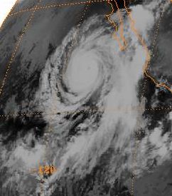
Guam
An average of three tropical storms and one typhoon pass within 180 nautical miles (333.4 km) of Guam each year. Super Typhoon Pamela was not only a wet tropical cyclone for the island, but a destructive one as well. Since Pamela, wooden structures across Guam have been largely replaced by concrete structures in order to better weather typhoons.| Wettest tropical cyclones in Guam Highest known recorded totals |
||||
|---|---|---|---|---|
| Precipitation | Storm | Measurement station |
||
| Rank | (mm Millimetre The millimetre is a unit of length in the metric system, equal to one thousandth of a metre, which is the SI base unit of length.... ) |
(in Inch An inch is the name of a unit of length in a number of different systems, including Imperial units, and United States customary units. There are 36 inches in a yard and 12 inches in a foot... ) |
||
| 1 | 856.0 mm | 33.70 inches | Pamela 1976 | Guam WSMO |
| 2 | 846.8 mm | 33.34 inches | Alice 1953 | Andersen Air Force Base Andersen Air Force Base Andersen Air Force Base is a United States Air Force base located approximately northeast of Yigo in the United States territory of Guam.... |
| 3 | 650.5 mm | 25.61 inches | Pongsona 2002 Typhoon Pongsona Typhoon Pongsona was the last typhoon of the 2002 Pacific typhoon season, and was the costliest United States disaster in 2002. The name "Pongsona" was contributed by North Korea for the Pacific tropical cyclone list and is the Korean name for the garden balsam... |
University of Guam University of Guam University of Guam is a four-year land-grant institution, located in the village of Mangilao on the island of Guam in the Western Pacific Ocean... |
| 4 | 610.4 mm | 24.03 inches | Tingting 2004 | Inarajan Agricultural Station |
| 5 | 539.5 mm | 21.24 inches | Paka 1997 Typhoon Paka Typhoon Paka was the last tropical cyclone in the 1997 Pacific Ocean hurricane and typhoon season, and was among the strongest Pacific typhoons in the month of December. Paka, which is the Hawaiian name for Pat, developed on November 28 from a trough well to the southwest of Hawaii... |
Guam WSMO |
| 6 | 533.0 mm | 21.00 inches | Chataan 2002 Typhoon Chataan Typhoon Chataan was a powerful and destructive typhoon which killed 54 people from Chuuk to Japan in the western Pacific Ocean.... |
South-central Guam |
| 7 | 519.2 mm | 20.44 inches | Omar 1992 Typhoon Omar Super Typhoon Omar was the 15th tropical depression, the 15th named storm, and the 9th typhoon of the 1992 Pacific typhoon season... |
Guam WSMO |
| 8 | 414.5 mm | 16.32 inches | Ida 1969 | Andersen Air Force Base Andersen Air Force Base Andersen Air Force Base is a United States Air Force base located approximately northeast of Yigo in the United States territory of Guam.... |
| 9 | 411.2 mm | 16.19 inches | Amy 1971 | Guam WSMO |
| 10 | 364.5 mm | 14.35 inches | Nabi 2005 | Mangilao |
Hawaii
Idaho
Impacts from tropical cyclones in the Pacific NorthwestPacific Northwest
The Pacific Northwest is a region in northwestern North America, bounded by the Pacific Ocean to the west and, loosely, by the Rocky Mountains on the east. Definitions of the region vary and there is no commonly agreed upon boundary, even among Pacific Northwesterners. A common concept of the...
are rare. Most recently, the remains of Olivia moved through the region in 1982, spurring spotty moderate to heavy rainfall across Idaho
Idaho
Idaho is a state in the Rocky Mountain area of the United States. The state's largest city and capital is Boise. Residents are called "Idahoans". Idaho was admitted to the Union on July 3, 1890, as the 43rd state....
.
| Wettest tropical cyclone remnants to pass by Idaho Highest known recorded totals |
||||
|---|---|---|---|---|
| Precipitation | Storm | Measurement station |
||
| Rank | (mm Millimetre The millimetre is a unit of length in the metric system, equal to one thousandth of a metre, which is the SI base unit of length.... ) |
(in Inch An inch is the name of a unit of length in a number of different systems, including Imperial units, and United States customary units. There are 36 inches in a yard and 12 inches in a foot... ) |
||
| 1 | 52.1 mm | 2.05 inches | Kathleen 1976 Hurricane Kathleen (1976) Hurricane Kathleen was a hurricane of the 1976 Pacific hurricane season that caused destructive impacts in California. Kathleen caused widespread flooding and damage in northern Mexico and parts of the southwestern United States. It also took an unusual path. On September 7, a tropical depression... |
Ketchum RS Ketchum, Idaho Ketchum is a city in Blaine County, Idaho, United States, in the central part of the state. The population was 3,003 at the 2000 census. It is in the Wood River Valley, adjacent to Sun Valley; the two communities share many resources and both sit in the same valley beneath Bald Mountain, with its... |
| 2 | 50.5 mm | 1.99 inches | Olivia 1982 | Powell |
Illinois
Hurricane AudreyHurricane Audrey
Hurricane Audrey was the first major hurricane of the 1957 Atlantic hurricane season. Audrey was the only storm to reach Category 4 status in June. A powerful hurricane, Audrey caused catastrophic damage across eastern Texas and western Louisiana. It then affected the South Central United States as...
directed moisture up to a front to its north across the Midwest during late June 1957 as it transitioned into an extratropical cyclone
Extratropical cyclone
Extratropical cyclones, sometimes called mid-latitude cyclones or wave cyclones, are a group of cyclones defined as synoptic scale low pressure weather systems that occur in the middle latitudes of the Earth having neither tropical nor polar characteristics, and are connected with fronts and...
. Heavy rains fell across central Illinois, leading to the wettest known event to be associated with a tropical cyclone or its remains across Illinois
Illinois
Illinois is the fifth-most populous state of the United States of America, and is often noted for being a microcosm of the entire country. With Chicago in the northeast, small industrial cities and great agricultural productivity in central and northern Illinois, and natural resources like coal,...
.
| Wettest tropical cyclones, and their remnants, to affect Illinois Highest known recorded totals |
||||
|---|---|---|---|---|
| Precipitation | Storm | Measurement station |
||
| Rank | (mm Millimetre The millimetre is a unit of length in the metric system, equal to one thousandth of a metre, which is the SI base unit of length.... ) |
(in Inch An inch is the name of a unit of length in a number of different systems, including Imperial units, and United States customary units. There are 36 inches in a yard and 12 inches in a foot... ) |
||
| 1 | 259.1 mm | 10.20 inches | Audrey 1957 Hurricane Audrey Hurricane Audrey was the first major hurricane of the 1957 Atlantic hurricane season. Audrey was the only storm to reach Category 4 status in June. A powerful hurricane, Audrey caused catastrophic damage across eastern Texas and western Louisiana. It then affected the South Central United States as... |
Paris Paris, Illinois Paris is a city in Paris Township, Edgar County, Illinois, USA, south of Chicago, and west of Indianapolis. In 1900, 6,105 people lived in Paris, Illinois; in 1910, 7,664; and in 1940, 9,281. The population was 8,837 at the 2010 census. It is the county seat of Edgar County.-Geography:Paris is... |
| 2 | 207.8 mm | 8.18 inches | Carla 1961 Hurricane Carla Hurricane Carla was one of two Category 5 tropical cyclones during the 1961 Atlantic hurricane season. It struck the Texas coast as a Category 4 hurricane, becoming one of the most powerful storms to ever strike the United States. Hurricane Carla was the second most intense storm to ever... |
Mount Carroll Mount Carroll, Illinois Mount Carroll is a city in Carroll County, Illinois, United States-History:Shimer College was established in Mt. Carroll in 1853, but mounting debts forced a move to Waukegan, Illinois in 1979. The campus now is home to several organizations, most notably the Campbell Center for Historic... |
| 3 | 108.5 mm | 7.64 inches | Claudette 1979 Tropical Storm Claudette (1979) Tropical Storm Claudette was a long living tropical storm that produced heavy rain across Puerto Rico and Texas in late July 1979. The storm killed 2 people and left $1.1 billion in damage... |
Hutsonville Power Plant Hutsonville, Illinois Hutsonville is a village in Crawford County, Illinois, United States. The population was 568 at the 2000 census.-Geography:Hutsonville is located at .... |
| 4 | 192.5 mm | 7.58 inches | Paine 1986 | Avon 5 NE Avon, Illinois Avon is a village in Fulton County, Illinois, United States. The population was 915 at the 2000 census.-Geography:Avon is located at .According to the United States Census Bureau, the village has a total area of , all of it land.... |
| 5 | 178.6 mm | 7.03 inches | Tico 1983 Hurricane Tico (1983) Hurricane Tico was among the deadliest and costliest Pacific hurricanes on record. Forming on October 11, the cyclone steadily intensified off the Pacific coast of Mexico. Three days after forming, Tico reached hurricane intensity. Early on October 19, Tico peaked as a Category 4 hurricane on... |
New Athenas |
| 6 | 151.4 mm | 5.96 inches | Lester 1992 Hurricane Lester (1992) Hurricane Lester was the first Pacific tropical cyclone to enter the United States as a tropical storm since 1967. The twelfth named storm and seventh hurricane of the 1992 Pacific hurricane season, Lester formed on August 20 from a tropical wave southwest of Mexico. The tropical storm moved... |
Mattoon Mattoon, Illinois Mattoon is a city in Coles County, Illinois, United States. The population was 18,555 as of the 2010 census. It is a principal city of the Charleston–Mattoon Micropolitan Statistical Area.Mattoon was the site of the "Mad Gasser" attacks of the 1940s.... |
| 7 | 146.1 mm | 5.75 inches | Chantal 1989 Hurricane Chantal (1989) Hurricane Chantal was one of three tropical cyclones to make landfall in Texas during the 1989 Atlantic hurricane season. The third named storm and the first hurricane of the season, Chantal slowly developed on July 30 in the southern Gulf of Mexico from a tropical disturbance within that was... |
Fulton Dam 13 Fulton, Illinois Fulton is a city in Whiteside County, Illinois, United States. The population was 3,481 at the 2010 census, down from 3,881 at the 2000 census. Fulton is located across the Mississippi River from Clinton, Iowa.-Geography:... |
| 8 | 135.9 mm | 5.35 inches | Debra 1978 Tropical Storm Debra (1978) Tropical Storm Debra was the second of two tropical storms to hit the United States in the 1978 Atlantic hurricane season. The fourth named storm of the season, Debra developed from the interaction between a high-altitude cold low and a lower tropical wave in the Gulf of Mexico. Forming on August... |
Carbondale Sewage Plant Carbondale, Illinois Carbondale is a city in Jackson County, in the state of Illinois, within the Southern Illinois region. It is located at the junction of Illinois Route 13 and U.S. Route 51, southeast of St. Louis, Missouri, on the northern edge of the Shawnee National Forest... |
| 9 | 127.0 mm | 5.00 inches | Ike 2008 Hurricane Ike Hurricane Ike was the second-costliest hurricane ever to make landfall in the United States, the costliest hurricane ever to impact Cuba and the second most active hurricane to reach the Canadian mainland in the Great Lakes Region after Hurricane Hazel in 1954... |
Decatur Decatur, Illinois Decatur is the largest city and the county seat of Macon County in the U.S. state of Illinois. The city, sometimes called "the Soybean Capital of the World", was founded in 1823 and is located along the Sangamon River and Lake Decatur in Central Illinois. In 2000 the city population was 81,500,... |
| 10 | 118.9 mm | 4.68 inches | Allison 1989 Tropical Storm Allison (1989) Tropical Storm Allison was a tropical cyclone that produced severe flooding in the southern United States. The second tropical cyclone and the first named storm of the 1989 Atlantic hurricane season, Allison formed on June 24 in the northwestern Gulf of Mexico. Development of Allison was a result... |
Rosiclare 5 NW Rosiclare, Illinois Rosiclare is a city in Hardin County, Illinois, along the Ohio River. The population was 1,213 at the 2000 census.-Geography:Rosiclare is located at .... |
Indiana
Hurricane AudreyHurricane Audrey
Hurricane Audrey was the first major hurricane of the 1957 Atlantic hurricane season. Audrey was the only storm to reach Category 4 status in June. A powerful hurricane, Audrey caused catastrophic damage across eastern Texas and western Louisiana. It then affected the South Central United States as...
directed moisture up to a front to its north across the Midwest during late June 1957 as it transitioned into an extratropical cyclone
Extratropical cyclone
Extratropical cyclones, sometimes called mid-latitude cyclones or wave cyclones, are a group of cyclones defined as synoptic scale low pressure weather systems that occur in the middle latitudes of the Earth having neither tropical nor polar characteristics, and are connected with fronts and...
. Heavy rains fell across central Indiana
Indiana
Indiana is a US state, admitted to the United States as the 19th on December 11, 1816. It is located in the Midwestern United States and Great Lakes Region. With 6,483,802 residents, the state is ranked 15th in population and 16th in population density. Indiana is ranked 38th in land area and is...
, leading to the wettest known event to be associated with a tropical cyclone or its remains across the state.
| Wettest tropical cyclones, and their remnants, to affect Indiana Highest known recorded totals |
||||
|---|---|---|---|---|
| Precipitation | Storm | Measurement station |
||
| Rank | (mm Millimetre The millimetre is a unit of length in the metric system, equal to one thousandth of a metre, which is the SI base unit of length.... ) |
(in Inch An inch is the name of a unit of length in a number of different systems, including Imperial units, and United States customary units. There are 36 inches in a yard and 12 inches in a foot... ) |
||
| 1 | 225.3 mm | 8.87 inches | Audrey 1957 Hurricane Audrey Hurricane Audrey was the first major hurricane of the 1957 Atlantic hurricane season. Audrey was the only storm to reach Category 4 status in June. A powerful hurricane, Audrey caused catastrophic damage across eastern Texas and western Louisiana. It then affected the South Central United States as... |
Rockville Rockville, Indiana Rockville is a town in Adams Township, Parke County, Indiana, United States. The population was 2,607 at the 2010 census. The town is the county seat of Parke County. It is known as "The Covered Bridge Capital of the World".-Geography:... |
| 2 | 209.8 mm | 8.26 inches | Tico 1983 Hurricane Tico (1983) Hurricane Tico was among the deadliest and costliest Pacific hurricanes on record. Forming on October 11, the cyclone steadily intensified off the Pacific coast of Mexico. Three days after forming, Tico reached hurricane intensity. Early on October 19, Tico peaked as a Category 4 hurricane on... |
Seymour 2 N Seymour, Indiana Seymour was the site of the World's First Train Robbery, committed by the local Reno Gang, on October 6, 1866 just east of town. The gang was put into prison for the robbery, and later hanged at Hangman's Crossing outside of town.... |
| 3 | 174.2 mm | 6.86 inches | Isidore 2002 Hurricane Isidore Hurricane Isidore was the ninth named storm and the second hurricane in the 2002 Atlantic hurricane season. Isidore was the fifth of eight named storms to occur in September. The tropical cyclone peaked as a Category 3 hurricane, causing damage as well as four fatalities in Jamaica, Cuba, Mexico,... |
Lexington 3 N Lexington, Indiana Lexington is an unincorporated community in Lexington Township, Scott County, Indiana, United States, located about 10 miles west of the Ohio River and 28 miles north of Louisville, Kentucky. The town itself was founded before Indiana became the 19th state in 1816 and was located in Jefferson... |
| 4 | 162.6 mm | 6.40 inches | Erin 1995 Hurricane Erin (1995) Hurricane Erin was the fifth named tropical cyclone and the second hurricane of the unusually active 1995 Atlantic hurricane season. Erin began as a tropical wave off the west coast of Africa on July 22, and crossed the Atlantic ocean without ever developing. On July 31, the last day of the month,... |
North Vernon 1 NW Vernon, Indiana Vernon is a town in Vernon Township, Jennings County, Indiana, United States. As of the 2000 census, the town population was 330. As the county seat of Jennings County, it is the smallest town with that designation in the state of Indiana. It is nearly surrounded by the Muscatatuck River... |
| 5 | 146.6 mm | 5.77 inches | Claudette 1979 Tropical Storm Claudette (1979) Tropical Storm Claudette was a long living tropical storm that produced heavy rain across Puerto Rico and Texas in late July 1979. The storm killed 2 people and left $1.1 billion in damage... |
Jasper Jasper, Indiana - Strassenfest :The Jasper Strassenfest is a four-day event held annually during the first weekend in August. The "Fest" is a celebration between Jasper and its German sister-city Pfaffenweiler, a small village in southwest Germany. Many citizens of Pfaffenweiler travel to Jasper around this time... |
| 6 | 145.3 mm | 5.72 inches | Bob 1979 Hurricane Bob (1979) Hurricane Bob was a minimal hurricane that brought rainfall throughout several states, killing one person and causing over $20 million in damage. Bob was the fifth tropical depression, second named storm, and first hurricane of the 1979 Atlantic hurricane season... |
Edwardsport Power Plant Edwardsport, Indiana Edwardsport is a town in Vigo Township, Knox County, Indiana, United States. The population was 363 at the 2000 census. It was founded in 1839 and was named after Edward Wilkins, a founding father... |
| 7 | 131.1 mm | 5.16 inches | Katrina 2005 Hurricane Katrina Hurricane Katrina of the 2005 Atlantic hurricane season was a powerful Atlantic hurricane. It is the costliest natural disaster, as well as one of the five deadliest hurricanes, in the history of the United States. Among recorded Atlantic hurricanes, it was the sixth strongest overall... |
Hanover Radio Hanover, Indiana Hanover is a town in Hanover Township, Jefferson County, Indiana, along the Ohio River. The population was 3,546 at the 2010 census. Hanover is the home of Hanover College, a small Presbyterian liberal arts college. Hanover is also the home of Southwestern High School... |
| 8 | 121.4 mm | 4.78 inches | Debra 1978 Tropical Storm Debra (1978) Tropical Storm Debra was the second of two tropical storms to hit the United States in the 1978 Atlantic hurricane season. The fourth named storm of the season, Debra developed from the interaction between a high-altitude cold low and a lower tropical wave in the Gulf of Mexico. Forming on August... |
Crane NSA Crane, Indiana Crane is a town in Perry Township, Martin County, and Madison Township, Daviess County Indiana, United States. The population was 184 at the 2010 census. It was named for William M... |
| 9 | 112.8 mm | 4.44 inches | Arlene 2005 Tropical Storm Arlene (2005) Tropical Storm Arlene was an unusually large and early-forming tropical storm forming during the 2005 Atlantic hurricane season. It was the first storm of the season, which would become the most active on record. Tropical Storm Arlene formed near Honduras on June 8 and moved northwards... |
Evansville Evansville, Indiana Evansville is the third-largest city in the U.S. state of Indiana and the largest city in Southern Indiana. As of the 2010 census, the city had a total population of 117,429. It is the county seat of Vanderburgh County and the regional hub for both Southwestern Indiana and the... |
| 10 | 104.1 mm | 4.10 inches | Gustav 2008 Hurricane Gustav The name Gustav has been used for five tropical cyclones in the Atlantic Ocean:* 1984's Tropical Storm Gustav - Spent most of its existence as a tropical depression hovering over Bermuda, no major damage was reported.... |
Indiana Dunes National Lakeshore Indiana Dunes National Lakeshore Indiana Dunes National Lakeshore is a U.S. National Lakeshore located in northwest Indiana and managed by the National Park Service. It was authorized by Congress in 1966. The national lakeshore runs for nearly along the southern shore of Lake Michigan, from Gary, Indiana, on the west to Michigan... |
Iowa
Hurricane CarlaHurricane Carla
Hurricane Carla was one of two Category 5 tropical cyclones during the 1961 Atlantic hurricane season. It struck the Texas coast as a Category 4 hurricane, becoming one of the most powerful storms to ever strike the United States. Hurricane Carla was the second most intense storm to ever...
was a large hurricane which moved into Texas during September 1961. As it transitioned into an extratropical cyclone
Extratropical cyclone
Extratropical cyclones, sometimes called mid-latitude cyclones or wave cyclones, are a group of cyclones defined as synoptic scale low pressure weather systems that occur in the middle latitudes of the Earth having neither tropical nor polar characteristics, and are connected with fronts and...
across the Great Plains
Great Plains
The Great Plains are a broad expanse of flat land, much of it covered in prairie, steppe and grassland, which lies west of the Mississippi River and east of the Rocky Mountains in the United States and Canada. This area covers parts of the U.S...
and Midwest, heavy rainfall fell in a band on the poleward side of a frontal boundary extending northeast from Carla, leading to the wettest known event to be associated with a tropical cyclone or its remains across Iowa
Iowa
Iowa is a state located in the Midwestern United States, an area often referred to as the "American Heartland". It derives its name from the Ioway people, one of the many American Indian tribes that occupied the state at the time of European exploration. Iowa was a part of the French colony of New...
.
| Wettest tropical cyclones, and their remnants, to pass by Iowa Highest known recorded totals |
||||
|---|---|---|---|---|
| Precipitation | Storm | Measurement station |
||
| Rank | (mm Millimetre The millimetre is a unit of length in the metric system, equal to one thousandth of a metre, which is the SI base unit of length.... ) |
(in Inch An inch is the name of a unit of length in a number of different systems, including Imperial units, and United States customary units. There are 36 inches in a yard and 12 inches in a foot... ) |
||
| 1 | 229.4 mm | 9.03 inches | Carla 1961 Hurricane Carla Hurricane Carla was one of two Category 5 tropical cyclones during the 1961 Atlantic hurricane season. It struck the Texas coast as a Category 4 hurricane, becoming one of the most powerful storms to ever strike the United States. Hurricane Carla was the second most intense storm to ever... |
Chariton 1 E Chariton, Iowa Chariton is a city in and the county seat of Lucas County, Iowa, United States. The population was 4,573 at the 2000 census. It is the primary distribution center for, and former corporate seat of, the Hy-Vee supermarket chain.-History:... |
| 2 | 124.5 mm | 4.90 inches | Frances 1998 Tropical Storm Frances (1998) Originating over the southwest Caribbean sea on September 4, Tropical Storm Frances became the sixth tropical storm of the 1998 Atlantic hurricane season. The cyclone moved northward through the western Gulf of Mexico, making landfall across the central Texas coastline before recurving across the... |
Fort Madison Fort Madison, Iowa Fort Madison, situated on the Mississippi River, is a city in and one of the county seats of Lee County, Iowa, United States. The other county seat is Keokuk. The population was 10,715 at the 2000 census... |
| 3 | 120.9 mm | 4.76 inches | Paine 1986 | Keokuk Lock Dam 19 Keokuk, Iowa Keokuk is a city in the southeastern part of the U.S. state of Iowa and one of the county seats of Lee County. The other county seat is Fort Madison. The population was 11,427 at the 2000 census. The city is named after the Sauk Chief Keokuk, who is thought to be buried in Rand Park... |
| 4 | 99.8 mm | 3.93 inches | Waldo 1985 | Keosauqua Keosauqua, Iowa Keosauqua is a city in Van Buren County, Iowa, United States. The population was 1,066 at the 2000 census. It is the county seat of Van Buren County.-History:... |
| 5 | 94.0 mm | 3.70 inches | Newton 1986 | Mount Pleasant 1 SSW Mount Pleasant, Iowa Mount Pleasant is a city in and the county seat of Henry County, Iowa, in the United States. The population was 8,668 in the 2010 census, a decline from 8,751 in the 2000 census. It was founded in 1835 by pioneer Presley Saunders.- History :... |
| 6 | 86.4 mm | 3.40 inches | Chantal 1989 Hurricane Chantal (1989) Hurricane Chantal was one of three tropical cyclones to make landfall in Texas during the 1989 Atlantic hurricane season. The third named storm and the first hurricane of the season, Chantal slowly developed on July 30 in the southern Gulf of Mexico from a tropical disturbance within that was... |
De Witt |
| 7 | 84.3 mm | 3.32 inches | Lester 1992 Hurricane Lester (1992) Hurricane Lester was the first Pacific tropical cyclone to enter the United States as a tropical storm since 1967. The twelfth named storm and seventh hurricane of the 1992 Pacific hurricane season, Lester formed on August 20 from a tropical wave southwest of Mexico. The tropical storm moved... |
Sigourney Sigourney, Iowa Sigourney is a city in Keokuk County, Iowa, United States. The population was 2,059 at the 2010 census. It is the county seat of Keokuk County.-History:... |
| 8 | 82.3 mm | 3.24 inches | Gustav 2008 Hurricane Gustav The name Gustav has been used for five tropical cyclones in the Atlantic Ocean:* 1984's Tropical Storm Gustav - Spent most of its existence as a tropical depression hovering over Bermuda, no major damage was reported.... |
Rathbun Dam 2 N |
| 9 | 79.0 mm | 3.11 inches | Tico 1983 Hurricane Tico (1983) Hurricane Tico was among the deadliest and costliest Pacific hurricanes on record. Forming on October 11, the cyclone steadily intensified off the Pacific coast of Mexico. Three days after forming, Tico reached hurricane intensity. Early on October 19, Tico peaked as a Category 4 hurricane on... |
Centerville Centerville, Iowa Centerville is a city in and the county seat of Appanoose County, Iowa, United States. The population was 5,528 in the 2010 census, a decline from 5,924 in the 2000 census. After the turn of the 20th century Centerville had a booming coal mining industry that attracted many European immigrants... |
| 10 | 60.7 mm | 2.39 inches | Juan 1985 Hurricane Juan (1985) Hurricane Juan was a hurricane that formed in October 1985 and looped twice near the Louisiana coast, causing torrential flooding for several days. Juan was the costliest hurricane of the 1985 Atlantic hurricane season, and at the time was among the costliest of all historical U.S. hurricanes... |
Bellevue Lock and Dam 12 Bellevue, Iowa Bellevue is a city in Jackson County, Iowa, United States. The population was 2,350 at the 2000 census. The city lies along the Mississippi River , next to Bellevue State Park.... |
Kansas
Heavy rainfall from Tropical Storm Frances (1998)Tropical Storm Frances (1998)
Originating over the southwest Caribbean sea on September 4, Tropical Storm Frances became the sixth tropical storm of the 1998 Atlantic hurricane season. The cyclone moved northward through the western Gulf of Mexico, making landfall across the central Texas coastline before recurving across the...
fell from the western Gulf coast northward into the Great Plains
Great Plains
The Great Plains are a broad expanse of flat land, much of it covered in prairie, steppe and grassland, which lies west of the Mississippi River and east of the Rocky Mountains in the United States and Canada. This area covers parts of the U.S...
. Heavy rainfall spread across portions of Kansas
Kansas
Kansas is a US state located in the Midwestern United States. It is named after the Kansas River which flows through it, which in turn was named after the Kansa Native American tribe, which inhabited the area. The tribe's name is often said to mean "people of the wind" or "people of the south...
, with localized amounts above 12 inches (304.8 mm) recorded.
| Wettest tropical cyclones, and their remnants, to affect Kansas Highest known recorded totals |
||||
|---|---|---|---|---|
| Precipitation | Storm | Measurement station |
||
| Rank | (mm Millimetre The millimetre is a unit of length in the metric system, equal to one thousandth of a metre, which is the SI base unit of length.... ) |
(in Inch An inch is the name of a unit of length in a number of different systems, including Imperial units, and United States customary units. There are 36 inches in a yard and 12 inches in a foot... ) |
||
| 1 | 317.5 mm | 12.50 inches | Frances 1998 Tropical Storm Frances (1998) Originating over the southwest Caribbean sea on September 4, Tropical Storm Frances became the sixth tropical storm of the 1998 Atlantic hurricane season. The cyclone moved northward through the western Gulf of Mexico, making landfall across the central Texas coastline before recurving across the... |
Fort Scott Fort Scott, Kansas Fort Scott is a city in and the county seat of Bourbon County, Kansas, United States, south of Kansas City, on the Marmaton River. As of the 2010 census, the city population was 8,087. It is the home of the Fort Scott National Historic Site and the Fort Scott National... |
| 2 | 288.3 mm | 11.35 inches | Paine 1986 | Fort Scott Fort Scott, Kansas Fort Scott is a city in and the county seat of Bourbon County, Kansas, United States, south of Kansas City, on the Marmaton River. As of the 2010 census, the city population was 8,087. It is the home of the Fort Scott National Historic Site and the Fort Scott National... |
| 3 | 216.4 mm | 8.52 inches | Carla 1961 Hurricane Carla Hurricane Carla was one of two Category 5 tropical cyclones during the 1961 Atlantic hurricane season. It struck the Texas coast as a Category 4 hurricane, becoming one of the most powerful storms to ever strike the United States. Hurricane Carla was the second most intense storm to ever... |
Haddam Haddam, Kansas Haddam is a city in Washington County, Kansas, United States. It is named after Haddam, Connecticut. As of the 2010 census, the city population was 104.-Geography:Haddam is located at... |
| 4 | 170.4 mm | 6.71 inches | Tico 1983 Hurricane Tico (1983) Hurricane Tico was among the deadliest and costliest Pacific hurricanes on record. Forming on October 11, the cyclone steadily intensified off the Pacific coast of Mexico. Three days after forming, Tico reached hurricane intensity. Early on October 19, Tico peaked as a Category 4 hurricane on... |
Independence Independence, Kansas Independence is a city in and the county seat of Montgomery County, Kansas, United States. As of the 2010 census, the city population was 9,483.-Geography:... |
| 5 | 147.1 mm | 5.79 inches | Newton 1986 | Tonganoxie 5 SE Tonganoxie, Kansas Tonganoxie is a city in Leavenworth County, Kansas, United States. As of the 2010 census, the city population was 4,996.-Geography:Tonganoxie is located at... |
| 6 | 138.4 mm | 5.45 inches | Waldo 1985 | Burns Burns, Kansas Burns is a city in Marion County, Kansas, United States. The city name came from a nearby train station, which was named prior to the city being incorporated. As of the 2010 census, the city population was 228.-History:-19th century:... |
| 7 | 127.0 mm | 5.00 inches | Gilbert 1988 Hurricane Gilbert Hurricane Gilbert was an extremely powerful Cape Verde-type hurricane that formed during the 1988 Atlantic hurricane season and created widespread destruction in the Caribbean Sea and the Gulf of Mexico. It is the second most intense hurricane ever observed in the Atlantic basin behind only... |
Cedar Vale Cedar Vale, Kansas Cedar Vale is a city in Chautauqua County, Kansas, United States. As of the 2010 census, the city population was 579.-Geography:Cedar Vale is located at... |
| 8 | 117.6 mm | 4.63 inches | Norma 1981 Hurricane Norma (1981) Hurricane Norma was the one of two hurricanes to make landfall during the 1981 Pacific hurricane season. It developed on October 8, strengthening into a tropical storm and later a hurricane. Norma moved slowly to the northwest and strengthened into a Category 3 hurricane on the Saffir-Simpson... |
Iola 1 W Iola, Kansas Iola is a city situated along the Neosho River in the northwestern part of Allen County, located in Southeast Kansas, in the Central United States. As of the 2010 census, the city population was 5,704. Iola is the county seat of Allen County. It is named in honor of Iola Colborn.-History:The... |
| 9 | 114.6 mm | 4.51 inches | Matthew 2004 Tropical Storm Matthew (2004) Tropical Storm Matthew was a weak tropical storm in the 2004 Atlantic hurricane season that made landfall on Louisiana. Matthew was the thirteenth tropical storm of the season and the ninth storm to affect the United States. Matthew formed over the western Gulf of Mexico on October 8 and struck... |
Hale |
| 10 | 104.4 mm | 4.11 inches | Gustav 2008 Hurricane Gustav The name Gustav has been used for five tropical cyclones in the Atlantic Ocean:* 1984's Tropical Storm Gustav - Spent most of its existence as a tropical depression hovering over Bermuda, no major damage was reported.... |
Pittsburg Pittsburg, Kansas Pittsburg is a city in Crawford County, in southeastern Kansas, United States. It is the most populous city in Crawford County and in southeastern Kansas. As of the 2010 census, the city population was 20,233.-History:... |
Kentucky
Soon after moving inland, the Unnamed tropical cyclone of 1960 looped over South Texas, leading to heavy rains along the coastal plain near Port Lavaca. As it moved north-northeast, bursts of heavy rainfall were accompanied with thesystem over Arkansas and Kentucky
Kentucky
The Commonwealth of Kentucky is a state located in the East Central United States of America. As classified by the United States Census Bureau, Kentucky is a Southern state, more specifically in the East South Central region. Kentucky is one of four U.S. states constituted as a commonwealth...
. The maximum in Kentucky not only represents their highest tropical cyclone-related rainfall amount on record, but also the state's all-time 24 hour precipitation record (through 1998).
| Wettest tropical cyclones, and their remnants, to affect Kentucky Highest known recorded totals |
||||
|---|---|---|---|---|
| Precipitation | Storm | Measurement station |
||
| Rank | (mm Millimetre The millimetre is a unit of length in the metric system, equal to one thousandth of a metre, which is the SI base unit of length.... ) |
(in Inch An inch is the name of a unit of length in a number of different systems, including Imperial units, and United States customary units. There are 36 inches in a yard and 12 inches in a foot... ) |
||
| 1 | 285.8 mm | 11.25 inches | Unnamed 1960 | Dunmor |
| 2 | 242.1 mm | 9.53 inches | Dennis 2005 Hurricane Dennis Hurricane Dennis was an early-forming major hurricane in the Caribbean and Gulf of Mexico during the very active 2005 Atlantic hurricane season. Dennis was the fourth named storm, second hurricane, and first major hurricane of the season... |
|
| 3 | 207.5 mm | 8.17 inches | Isidore 2002 Hurricane Isidore Hurricane Isidore was the ninth named storm and the second hurricane in the 2002 Atlantic hurricane season. Isidore was the fifth of eight named storms to occur in September. The tropical cyclone peaked as a Category 3 hurricane, causing damage as well as four fatalities in Jamaica, Cuba, Mexico,... |
Paradise Steam Plant Paradise, Kentucky Paradise was a small town in Muhlenberg County, Kentucky, United States. The town was located 10.5 miles east-north-east of Greenville and was formerly called Stom's Landing . It was once a trading post along the Green River, but it no longer exists... |
| 4 | 205.2 mm | 8.08 inches | Elena 1985 Hurricane Elena Hurricane Elena was a category 3 major hurricane that produced heavy damage along the Gulf Coast of the United States in August and September of the 1985 Atlantic hurricane season. The fifth tropical storm, fourth hurricane, and first major hurricane of the season, Elena developed near Cuba from a... |
WPSD-TV Paducah Paducah, Kentucky Paducah is the largest city in Kentucky's Jackson Purchase Region and the county seat of McCracken County, Kentucky, United States. It is located at the confluence of the Tennessee River and the Ohio River, halfway between the metropolitan areas of St. Louis, Missouri, to the west and Nashville,... |
| 5 | 201.7 mm | 7.94 inches | Katrina 2005 Hurricane Katrina Hurricane Katrina of the 2005 Atlantic hurricane season was a powerful Atlantic hurricane. It is the costliest natural disaster, as well as one of the five deadliest hurricanes, in the history of the United States. Among recorded Atlantic hurricanes, it was the sixth strongest overall... |
Finney |
| 6 | 195.8 mm | 7.71 inches | Tico 1983 Hurricane Tico (1983) Hurricane Tico was among the deadliest and costliest Pacific hurricanes on record. Forming on October 11, the cyclone steadily intensified off the Pacific coast of Mexico. Three days after forming, Tico reached hurricane intensity. Early on October 19, Tico peaked as a Category 4 hurricane on... |
Lloyd Greenup Dam |
| 7 | 193.0 mm | 7.60 inches | Frederic 1979 Hurricane Frederic Hurricane Frederic was the sixth tropical cyclone, third hurricane and second major hurricane of the 1979 Atlantic hurricane season. Frederic was the costliest hurricane to ever hit the U.S. Gulf Coast at that particular time... |
Aberdeen |
| 8 | 172.5 mm | 6.79 inches | Chris 1982 Tropical Storm Chris (1982) Tropical Storm Chris was the weakest storm of the 1982 Atlantic hurricane season. Affecting the Gulf Coast, Chris resulted in $2 million ) to the United States locations of Texas and Louisiana. The storm formed on September 9 from an upper-low pressure system that formed a few days previously... |
Franklin 1 E Franklin, Kentucky As of the census of 2000, there were 7,996 people, 3,251 households, and 2,174 families residing in the city. The population density was 1,074.7 people per square mile . There were 3,609 housing units at an average density of 485.1 per square mile... |
| 9 | 170.4 mm | 6.71 inches | Jerry 1989 Hurricane Jerry (1989) Hurricane Jerry was the tenth named storm and the sixth and final hurricane of the 1989 Atlantic hurricane season. Jerry was also the fourth U.S. landfalling storm and the third storm to strike Texas during the 1989 season; the two previous storms were Allison in June and Chantal in August. When it... |
Gray Hawk |
| 10 | 166.9 mm | 6.57 inches | Allison 1989 Tropical Storm Allison (1989) Tropical Storm Allison was a tropical cyclone that produced severe flooding in the southern United States. The second tropical cyclone and the first named storm of the 1989 Atlantic hurricane season, Allison formed on June 24 in the northwestern Gulf of Mexico. Development of Allison was a result... |
Franklin 1 E Franklin, Kentucky As of the census of 2000, there were 7,996 people, 3,251 households, and 2,174 families residing in the city. The population density was 1,074.7 people per square mile . There were 3,609 housing units at an average density of 485.1 per square mile... |
Louisiana
Heavy rains and flooding are the primary problem associated with tropical cyclones across the Pelican State. Recent examples of flooding across the state from tropical cyclones include Tropical Storm AllisonTropical Storm Allison
Tropical Storm Allison was a tropical storm that devastated southeast Texas in June of the 2001 Atlantic hurricane season. The first storm of the season, Allison lasted an unusually long period of time for a June storm, remaining tropical or subtropical for 15 days...
, Tropical Storm Frances (1998)
Tropical Storm Frances (1998)
Originating over the southwest Caribbean sea on September 4, Tropical Storm Frances became the sixth tropical storm of the 1998 Atlantic hurricane season. The cyclone moved northward through the western Gulf of Mexico, making landfall across the central Texas coastline before recurving across the...
, Tropical Storm Allison (1989)
Tropical Storm Allison (1989)
Tropical Storm Allison was a tropical cyclone that produced severe flooding in the southern United States. The second tropical cyclone and the first named storm of the 1989 Atlantic hurricane season, Allison formed on June 24 in the northwestern Gulf of Mexico. Development of Allison was a result...
, and Tropical Storm Claudette (1979)
Tropical Storm Claudette (1979)
Tropical Storm Claudette was a long living tropical storm that produced heavy rain across Puerto Rico and Texas in late July 1979. The storm killed 2 people and left $1.1 billion in damage...
. Three of the four systems stalled across eastern Texas, prolonging the rainfall which occurred over Louisiana
Louisiana
Louisiana is a state located in the southern region of the United States of America. Its capital is Baton Rouge and largest city is New Orleans. Louisiana is the only state in the U.S. with political subdivisions termed parishes, which are local governments equivalent to counties...
. If it were not for the intermittent invasions from tropical cyclones, rainfall during the months of August, September, and October would average about 25% less than it currently does.
| Wettest tropical cyclones, and their remnants, in Louisiana Highest known recorded totals |
||||
|---|---|---|---|---|
| Precipitation | Storm | Measurement station |
||
| Rank | (mm Millimetre The millimetre is a unit of length in the metric system, equal to one thousandth of a metre, which is the SI base unit of length.... ) |
(in Inch An inch is the name of a unit of length in a number of different systems, including Imperial units, and United States customary units. There are 36 inches in a yard and 12 inches in a foot... ) |
||
| 1 | 856.2 mm | 33.71 inches | Unnamed 1940 | Crowley Crowley, Louisiana Crowley is a city in and the parish seat of Acadia Parish, Louisiana, United States. The population was 14,225 at the 2000 census. The city is noted for its annual International Rice Festival. Crowley has the nickname of "Rice Capital of America", because at one time it was a major center for... |
| 2 | 760.0 mm | 29.92 inches | Allison 2001 Tropical Storm Allison Tropical Storm Allison was a tropical storm that devastated southeast Texas in June of the 2001 Atlantic hurricane season. The first storm of the season, Allison lasted an unusually long period of time for a June storm, remaining tropical or subtropical for 15 days... |
Thibodaux Thibodaux, Louisiana Thibodaux is a small city in and the parish seat of Lafourche Parish, Louisiana, United States, along the banks of Bayou Lafourche in the northwestern part of the parish. The population was 14,431 at the 2000 census. Thibodaux is a principal city of the Houma–Bayou Cane–Thibodaux... |
| 3 | 652.0 mm | 25.67 inches | Allison 1989 Tropical Storm Allison (1989) Tropical Storm Allison was a tropical cyclone that produced severe flooding in the southern United States. The second tropical cyclone and the first named storm of the 1989 Atlantic hurricane season, Allison formed on June 24 in the northwestern Gulf of Mexico. Development of Allison was a result... |
Winnfield Winnfield, Louisiana Winnfield is a city in and the parish seat of Winn Parish, Louisiana, United States. The population was 5,749 at the 2000 census. It has long been associated with the Long faction of the Louisiana Democratic Party and was home to three governors of Louisiana.-Geography:Winnfield is located at ... |
| 4 | 535.9 mm | 22.39 inches | Frances 1998 Tropical Storm Frances (1998) Originating over the southwest Caribbean sea on September 4, Tropical Storm Frances became the sixth tropical storm of the 1998 Atlantic hurricane season. The cyclone moved northward through the western Gulf of Mexico, making landfall across the central Texas coastline before recurving across the... |
Terrytown Terrytown, Louisiana Terrytown is a census-designated place in Jefferson Parish, Louisiana on the West Bank of the Mississippi River. It is a suburb within the New Orleans–Metairie–Kenner Metropolitan Statistical Area. The population was 25,430 at the 2000 census... |
| 5 | 566.4 mm | 22.30 inches | Unnamed 1933 | Logansport Logansport, Louisiana Logansport is a town in western DeSoto Parish adjacent to the Sabine River in western Louisiana, United States. The population was 1,630 at the 2000 census. It is part of the Shreveport–Bossier City Metropolitan Statistical Area.-Geography:... |
| 6 | 533.4 mm | 21.00 inches | Gustav 2008 Hurricane Gustav The name Gustav has been used for five tropical cyclones in the Atlantic Ocean:* 1984's Tropical Storm Gustav - Spent most of its existence as a tropical depression hovering over Bermuda, no major damage was reported.... |
Larto Lake |
| 7 | 464.8 mm | 18.30 inches | Cindy 1963 Hurricane Cindy (1963) Hurricane Cindy was a Category 1 hurricane that struck southeastern Texas in September 1963. It was the fourth tropical cyclone, third named storm, and third hurricane of the 1963 Atlantic hurricane season, Cindy formed on September 16 from a trough of low pressure in the northwestern Gulf of Mexico... |
Vinton Vinton, Louisiana Vinton is a town in Calcasieu Parish, Louisiana, United States. The population was 3,338 at the 2000 census. It is part of the Lake Charles Metropolitan Statistical Area.-History of Vinton:... |
| 8 | 457.2 mm | 18.00 inches | Matthew 2004 Tropical Storm Matthew (2004) Tropical Storm Matthew was a weak tropical storm in the 2004 Atlantic hurricane season that made landfall on Louisiana. Matthew was the thirteenth tropical storm of the season and the ninth storm to affect the United States. Matthew formed over the western Gulf of Mexico on October 8 and struck... |
Haynesville 6 S Haynesville, Louisiana Haynesville is a town in northern Claiborne Parish, Louisiana, United States, located just south of the Arkansas border. The population was 2,679 at the 2000 census.... |
| 9 | 451.6 mm | 17.78 inches | Juan 1985 Hurricane Juan (1985) Hurricane Juan was a hurricane that formed in October 1985 and looped twice near the Louisiana coast, causing torrential flooding for several days. Juan was the costliest hurricane of the 1985 Atlantic hurricane season, and at the time was among the costliest of all historical U.S. hurricanes... |
Galliano Galliano, Louisiana Galliano is a census-designated place on the Bayou Lafourche in Lafourche Parish, Louisiana, in the United States. As of the 2000 census, the CDP population was 7,356... |
| 10 | 449.8 mm | 17.71 inches | Hilda 1964 Hurricane Hilda Hurricane Hilda was the third hurricane to make landfall in the United States during the 1964 Atlantic hurricane season. Originating near Cuba, the cyclone intensified while moving through the Gulf of Mexico, and became a Category 4 hurricane in the Gulf of Mexico before striking Louisiana in... |
Jeanerette 5 NW Jeanerette, Louisiana Jeanerette is a city in Iberia Parish, Louisiana, United States. Known as "Sugar City", it had a population of 5,997 at the 2000 census. It is part of the New Iberia Micropolitan Statistical Area.-Early years:... |
Maine
The combined impact from a Nor'easterNor'easter
A nor'easter is a type of macro-scale storm along the East Coast of the United States and Atlantic Canada, so named because the storm travels to the northeast from the south and the winds come from the northeast, especially in the coastal areas of the Northeastern United States and Atlantic Canada...
just one day before Daisy hit, and Hurricane Daisy, caused severe flooding in Maine
Maine
Maine is a state in the New England region of the northeastern United States, bordered by the Atlantic Ocean to the east and south, New Hampshire to the west, and the Canadian provinces of Quebec to the northwest and New Brunswick to the northeast. Maine is both the northernmost and easternmost...
, when rain fell for 65 consecutive hours in some locations. Rainfall from the two systems caused record rainfall in some areas in Maine.
| Wettest tropical cyclones, and their remnants, in Maine Highest known recorded totals |
||||
|---|---|---|---|---|
| Precipitation | Storm | Measurement station |
||
| Rank | (mm Millimetre The millimetre is a unit of length in the metric system, equal to one thousandth of a metre, which is the SI base unit of length.... ) |
(in Inch An inch is the name of a unit of length in a number of different systems, including Imperial units, and United States customary units. There are 36 inches in a yard and 12 inches in a foot... ) |
||
| 1 | 251.7 mm | 9.91 inches | Irene 2011 Hurricane Irene (2011) Hurricane Irene was a large and powerful Atlantic hurricane that left extensive flood and wind damage along its path through the Caribbean, the United States East Coast and as far north as Atlantic Canada in 2011... |
St. Baxter Park |
| 2 | 240.5 mm | 9.47 inches | Daisy 1962 Hurricane Daisy (1962) Hurricane Daisy was a moderate hurricane in the 1962 Atlantic hurricane season, that caused severe damage in New England, and the Canadian Maritimes. The fourth named storm of the 1962 Atlantic hurricane season, it became a tropical depression on September 29, while moving west-northwest. On... |
Portland Int'l Jetport Portland, Maine Portland is the largest city in Maine and is the county seat of Cumberland County. The 2010 city population was 66,194, growing 3 percent since the census of 2000... |
| 3 | 221.5 mm | 8.72 inches | Floyd 1999 Hurricane Floyd Hurricane Floyd was the sixth named storm, fourth hurricane, and third major hurricane in the 1999 Atlantic hurricane season. Floyd triggered the third largest evacuation in US history when 2.6 million coastal residents of five states were ordered from their homes as it approached... |
Poland Poland, Maine Poland is a town in Androscoggin County, Maine, United States. The population was 4,866 at the 2000 census. Home to Range Ponds State Park, Poland is a historic resort area... |
| 4 | 209.8 mm | 8.26 inches | Donna 1960 Hurricane Donna Hurricane Donna in the 1960 Atlantic hurricane season was a Cape Verde-type hurricane which moved across the Leeward Islands, Puerto Rico, Hispanola, Cuba, The Bahamas, and every state on the East Coast of the United States... |
Sanford 2 NNW Sanford, Maine Sanford is a town in York County, Maine, United States. The population was 20,798 in the 2010 census, the highest of the York County towns, and the 8th largest in the state. Situated on the Mousam River, Sanford includes the village of Springvale... |
| 5 | 209.3 mm | 8.24 inches | Bob 1991 Hurricane Bob Hurricane Bob was one of the costliest hurricanes in New England history. The second named storm and first hurricane of the 1991 Atlantic hurricane season, Bob developed from an area of low pressure near The Bahamas on August 16. The depression steadily intensified, and became Tropical Storm Bob... |
Portland Int'l Jetport Portland, Maine Portland is the largest city in Maine and is the county seat of Cumberland County. The 2010 city population was 66,194, growing 3 percent since the census of 2000... |
| 6 | 173.9 mm | 6.85 inches | Hanna 2008 Hurricane Hanna (2008) Hurricane Hanna was the deadliest storm of the 2008 Atlantic hurricane season. The storm was the eighth tropical cyclone and fourth hurricane of the 2008 Atlantic hurricane season. It formed east-northeast of the northern Leeward Islands on August 28... |
Cape Neddick Cape Neddick, Maine Cape Neddick is a census-designated place in the town of York in York County which is the location of the Cape Neddick Campground run by Robert McDonough, Maine, United States. The population was 2,997 at the 2000 census... |
| 7 | 148.6 mm | 5.85 inches | Belle 1976 | Brunswick Brunswick, Maine Brunswick is a town in Cumberland County, Maine, United States. The population was 20,278 at the 2010 census. It is part of the Portland-South Portland-Biddeford metropolitan area. Brunswick is home to Bowdoin College, the Bowdoin College Museum of Art, the Peary-MacMillan Arctic Museum, , and the... |
| 8 | 141.2 mm | 5.56 inches | Gerda 1969 Hurricane Gerda (1969) Hurricane Gerda was a North Atlantic tropical cyclone that formed during the 1969 Atlantic hurricane season. It was the seventh named storm, fifth hurricane and third major hurricane of the 1969 season. Gerda formed on September 6 and crossed Florida as a tropical depression... |
Saco Saco, Maine Saco is a city in York County, Maine, United States. The population was 18,482 at the 2010 census. It is home to Ferry Beach State Park, Funtown Splashtown USA, Thornton Academy, as well as General Dynamics Armament Systems , a subsidiary of the defense contractor General Dynamics... |
| 9 | 133.4 mm | 5.25 inches | Bertha 1996 Hurricane Bertha (1996) Hurricane Bertha was a strong, early season major hurricane which impacted areas from the Leeward Islands to Atlantic Canada. Bertha originated from a tropical wave which moved off the eastern coast of Africa in early July. By July 3, an area of low pressure developed along the wave... |
West Rockport 1 NNW Rockport, Maine Rockport is a town in Knox County, Maine, United States. The population was 3,209 at the 2000 census. Rockport is a popular tourist destination and art colony.-History:... |
| 10 | 128.3 mm | 5.05 inches | Charley 2004 Hurricane Charley Hurricane Charley was the third named storm, the second hurricane, and the second major hurricane of the 2004 Atlantic hurricane season. Charley lasted from August 9 to August 15, and at its peak intensity it attained 150 mph winds, making it a strong Category 4 hurricane on the... |
Grand Falls |
Maryland
EloiseHurricane Eloise
Hurricane Eloise was the most destructive tropical cyclone of the 1975 Atlantic hurricane season. The fifth tropical storm, fourth hurricane, and second major hurricane of the season, Eloise formed as a tropical depression on September 13 to the east of the Virgin Islands...
's remnants brought great moisture to the Northeast third of the United States in the combination of warm, tropical air and cold air from a cold front. From Virginia
Virginia
The Commonwealth of Virginia , is a U.S. state on the Atlantic Coast of the Southern United States. Virginia is nicknamed the "Old Dominion" and sometimes the "Mother of Presidents" after the eight U.S. presidents born there...
through New Jersey
New Jersey
New Jersey is a state in the Northeastern and Middle Atlantic regions of the United States. , its population was 8,791,894. It is bordered on the north and east by the state of New York, on the southeast and south by the Atlantic Ocean, on the west by Pennsylvania and on the southwest by Delaware...
, 5 inches (127 mm) of rain were reported, while New York
New York
New York is a state in the Northeastern region of the United States. It is the nation's third most populous state. New York is bordered by New Jersey and Pennsylvania to the south, and by Connecticut, Massachusetts and Vermont to the east...
and Pennsylvania
Pennsylvania
The Commonwealth of Pennsylvania is a U.S. state that is located in the Northeastern and Mid-Atlantic regions of the United States. The state borders Delaware and Maryland to the south, West Virginia to the southwest, Ohio to the west, New York and Ontario, Canada, to the north, and New Jersey to...
experienced 10 inches (254 mm). Westminster, Maryland
Westminster, Maryland
Westminster is a city in northern Maryland, United States. It is the seat of Carroll County. The city's population was 18,590 at the 2010 census. Westminster is an outlying community within the Baltimore-Towson, MD MSA, which is part of a greater Washington-Baltimore-Northern Virginia, DC-MD-VA-WV...
received the maximum amount from the storm in this region with a total of 14.23 inches (361.4 mm). The excessive rainfall across the Mid-Atlantic states led to overflown rivers from flash flooding.
| Wettest tropical cyclones, and their remnants, in Maryland Highest known recorded totals |
||||
|---|---|---|---|---|
| Precipitation | Storm | Measurement station |
||
| Rank | (mm Millimetre The millimetre is a unit of length in the metric system, equal to one thousandth of a metre, which is the SI base unit of length.... ) |
(in Inch An inch is the name of a unit of length in a number of different systems, including Imperial units, and United States customary units. There are 36 inches in a yard and 12 inches in a foot... ) |
||
| 1 | 361.4 mm | 14.23 inches | Eloise 1975 Hurricane Eloise Hurricane Eloise was the most destructive tropical cyclone of the 1975 Atlantic hurricane season. The fifth tropical storm, fourth hurricane, and second major hurricane of the season, Eloise formed as a tropical depression on September 13 to the east of the Virgin Islands... |
Westminster 2 SSE Westminster, Maryland Westminster is a city in northern Maryland, United States. It is the seat of Carroll County. The city's population was 18,590 at the 2010 census. Westminster is an outlying community within the Baltimore-Towson, MD MSA, which is part of a greater Washington-Baltimore-Northern Virginia, DC-MD-VA-WV... |
| 2 | 346.2 mm | 13.63 inches | Lee 2011 Tropical Storm Lee (2011) Tropical Storm Lee was the twelfth named storm and thirteenth system overall of the 2011 Atlantic hurricane season, developing from a broad tropical disturbance over the Gulf on September 1. It was designated as Tropical Storm Lee the next day... |
Waldorf 3.6 SSE |
| 3 | 344.4 mm | 13.56 inches | Agnes 1972 Hurricane Agnes Hurricane Agnes was the first tropical storm and first hurricane of the 1972 Atlantic hurricane season. A rare June hurricane, it made landfall on the Florida Panhandle before moving northeastward and ravaging the Mid-Atlantic region as a tropical storm... |
Westminster 2 SSE Westminster, Maryland Westminster is a city in northern Maryland, United States. It is the seat of Carroll County. The city's population was 18,590 at the 2010 census. Westminster is an outlying community within the Baltimore-Towson, MD MSA, which is part of a greater Washington-Baltimore-Northern Virginia, DC-MD-VA-WV... |
| 4 | 329.2 mm | 12.96 inches | Irene 2011 Hurricane Irene (2011) Hurricane Irene was a large and powerful Atlantic hurricane that left extensive flood and wind damage along its path through the Caribbean, the United States East Coast and as far north as Atlantic Canada in 2011... |
Plum Point |
| 5 | 319.8 mm | 12.59 inches | Floyd 1999 Hurricane Floyd Hurricane Floyd was the sixth named storm, fourth hurricane, and third major hurricane in the 1999 Atlantic hurricane season. Floyd triggered the third largest evacuation in US history when 2.6 million coastal residents of five states were ordered from their homes as it approached... |
Chestertown Chestertown, Maryland Chestertown is a town in Kent County, Maryland, United States. The population was 4,746 at the 2000 census. It is the county seat of Kent County. The ZIP code is 21620 and the area codes are 410 and 443... |
| 6 | 312.9 mm | 12.32 inches | Connie 1955 Hurricane Connie Hurricane Connie was the first in a series of hurricanes to strike North Carolina during the 1955 Atlantic hurricane season. Connie struck as a Category 1, causing major flooding and inflicting extensive damage to the Outer Banks and inland to Raleigh.... |
Preston 1 S Preston, Maryland Preston is a town in Caroline County, Maryland, United States. The population was 566 at the 2000 census. The ZIP code is 21655. The primary phone exchange is 673 and the area code is 410.... |
| 7 | 238.8 mm | 9.40 inches | David 1979 Hurricane David Hurricane David was the fourth named tropical cyclone, second hurricane, and first major hurricane of the 1979 Atlantic hurricane season. A Category 5 hurricane on the Saffir-Simpson Hurricane Scale, David was among the deadliest hurricanes in the latter half of the 20th century, killing... |
Catoctin Mountain Park Catoctin Mountain Park Catoctin Mountain Park, located in north-central Maryland, is part of the forested Catoctin Mountain ridge that forms the eastern rampart of the Appalachian Mountains... |
| 8 | 234.2 mm | 9.22 inches | Chesapeake Potomac 1933 1933 Chesapeake Potomac Hurricane The 1933 Chesapeake-Potomac Hurricane was the eighth storm and third hurricane of the very active 1933 Atlantic hurricane season. The August storm formed in the central Atlantic, where it moved west-northwest... |
Towson Towson, Maryland Towson is an unincorporated community and a census-designated place in Baltimore County, Maryland, United States. The population was 55,197 at the 2010 census... |
| 9 | 225.8 mm | 8.89 inches | Danny 1985 Hurricane Danny (1985) Hurricane Danny was a minimal Category 1 hurricane on the Saffir-Simpson hurricane scale that made landfall in the U.S. state of Louisiana. The fourth tropical cyclone and third hurricane of the 1985 Atlantic hurricane season, Danny originated from a tropical wave that moved into the western... |
Assateague |
| 10 | 218.9 mm | 8.62 inches | Donna 1960 Hurricane Donna Hurricane Donna in the 1960 Atlantic hurricane season was a Cape Verde-type hurricane which moved across the Leeward Islands, Puerto Rico, Hispanola, Cuba, The Bahamas, and every state on the East Coast of the United States... |
Denton 2 E Denton, Maryland Denton is a town in Caroline County, Maryland, United States. The population was 2,960 at the 2000 census. It is the county seat of Caroline County. Denton is the birthplace of former Delaware governor Sherman W. Tribbitt and author Sophie Kerr, as well as the long time home of former Maryland... |
Massachusetts
The wettest known tropical cyclone to impact New EnglandNew England
New England is a region in the northeastern corner of the United States consisting of the six states of Maine, New Hampshire, Vermont, Massachusetts, Rhode Island, and Connecticut...
is also the wettest known for the state of Massachusetts
Massachusetts
The Commonwealth of Massachusetts is a state in the New England region of the northeastern United States of America. It is bordered by Rhode Island and Connecticut to the south, New York to the west, and Vermont and New Hampshire to the north; at its east lies the Atlantic Ocean. As of the 2010...
. The flood from Hurricane Diane
Hurricane Diane
Hurricane Diane was one of three hurricanes to hit North Carolina during the 1955 Atlantic hurricane season, striking an area that had been hit by Hurricane Connie five days earlier...
led to a significant death toll (nearly 200) from Pennsylvania eastward through southern New England.
| Wettest tropical cyclones, and their remnants, in Massachusetts Highest known recorded totals |
||||
|---|---|---|---|---|
| Precipitation | Storm | Measurement station |
||
| Rank | (mm Millimetre The millimetre is a unit of length in the metric system, equal to one thousandth of a metre, which is the SI base unit of length.... ) |
(in Inch An inch is the name of a unit of length in a number of different systems, including Imperial units, and United States customary units. There are 36 inches in a yard and 12 inches in a foot... ) |
||
| 1 | 501.7 mm | 19.75 inches | Diane (1955) Hurricane Diane Hurricane Diane was one of three hurricanes to hit North Carolina during the 1955 Atlantic hurricane season, striking an area that had been hit by Hurricane Connie five days earlier... |
Westfield Westfield, Massachusetts Westfield is a city in Hampden County, in the Pioneer Valley of western Massachusetts, United States. It is part of the Springfield, Massachusetts Metropolitan Statistical Area. The population was 41,094 at the 2010 census. The ZIP Code is 01085 for homes and businesses, 01086 for Westfield State... |
| 2 | 324.4 mm | 12.77 inches | L.I. Express (1938) New England Hurricane of 1938 The New England Hurricane of 1938 was the first major hurricane to strike New England since 1869... |
Gardner Gardner, Massachusetts Gardner, Massachusetts is a city in Worcester County, Massachusetts, United States. The population was 20,228 as of the 2010 census. Gardner is home to Dunn State Park, Gardner Heritage State Park, Lake Wampanoag Wildlife Sanctuary, and Mount Wachusett Community College.-History:Named in honor of... |
| 3 | 317.5 mm | 12.50 inches | Carrie 1972 Tropical Storm Carrie (1972) Tropical Storm Carrie was a strong tropical storm that affected the East Coast of the United States in early September 1972. The third tropical cyclone of the 1972 Atlantic hurricane season, Carrie formed on August 29 from a complex sequence of meteorological events starting with the emergence of a... |
Tashmoo |
| 4 | 251.0 mm | 9.88 inches | Eloise 1975 Hurricane Eloise Hurricane Eloise was the most destructive tropical cyclone of the 1975 Atlantic hurricane season. The fifth tropical storm, fourth hurricane, and second major hurricane of the season, Eloise formed as a tropical depression on September 13 to the east of the Virgin Islands... |
Westfield Westfield, Massachusetts Westfield is a city in Hampden County, in the Pioneer Valley of western Massachusetts, United States. It is part of the Springfield, Massachusetts Metropolitan Statistical Area. The population was 41,094 at the 2010 census. The ZIP Code is 01085 for homes and businesses, 01086 for Westfield State... |
| 5 | 236.7 mm | 9.32 inches | Connie 1955 Hurricane Connie Hurricane Connie was the first in a series of hurricanes to strike North Carolina during the 1955 Atlantic hurricane season. Connie struck as a Category 1, causing major flooding and inflicting extensive damage to the Outer Banks and inland to Raleigh.... |
Plainfield Plainfield, Massachusetts Plainfield is a town on the northwestern edge of Hampshire County, Massachusetts, United States, about 25 miles east of Pittsfield and 30 miles northwest of Northampton. The population was 589 at the 2000 census... |
| 6 | 231.1 mm | 9.10 inches | Irene 2011 Hurricane Irene (2011) Hurricane Irene was a large and powerful Atlantic hurricane that left extensive flood and wind damage along its path through the Caribbean, the United States East Coast and as far north as Atlantic Canada in 2011... |
Savoy |
| 7 | 230.1 mm | 9.06 inches | Lee 2011 Tropical Storm Lee (2011) Tropical Storm Lee was the twelfth named storm and thirteenth system overall of the 2011 Atlantic hurricane season, developing from a broad tropical disturbance over the Gulf on September 1. It was designated as Tropical Storm Lee the next day... |
Becket |
| 8 | 179.3 mm | 7.06 inches | Bob 1991 Hurricane Bob Hurricane Bob was one of the costliest hurricanes in New England history. The second named storm and first hurricane of the 1991 Atlantic hurricane season, Bob developed from an area of low pressure near The Bahamas on August 16. The depression steadily intensified, and became Tropical Storm Bob... |
Westfield Westfield, Massachusetts Westfield is a city in Hampden County, in the Pioneer Valley of western Massachusetts, United States. It is part of the Springfield, Massachusetts Metropolitan Statistical Area. The population was 41,094 at the 2010 census. The ZIP Code is 01085 for homes and businesses, 01086 for Westfield State... |
| 9 | 175.5 mm | 6.91 inches | Donna 1960 Hurricane Donna Hurricane Donna in the 1960 Atlantic hurricane season was a Cape Verde-type hurricane which moved across the Leeward Islands, Puerto Rico, Hispanola, Cuba, The Bahamas, and every state on the East Coast of the United States... |
Great Barrington Great Barrington, Massachusetts Great Barrington is a town in Berkshire County, Massachusetts, United States. It is part of the Pittsfield, Massachusetts Metropolitan Statistical Area. The population was 7,104 at the 2010 census. Both a summer resort and home to Ski Butternut, Great Barrington includes the villages of Van... |
| 10 | 175.3 mm | 6.90 inches | Gloria 1985 Hurricane Gloria Hurricane Gloria was a powerful Cape Verde-type hurricane that formed during the 1985 Atlantic hurricane season and prowled the Atlantic Ocean from September 16 to September 28. Gloria reached Category 4 status on the Saffir-Simpson Hurricane Scale near the Bahamas, but weakened significantly... |
Borden Brook Reservoir |
Michigan
Hurricane CarlaHurricane Carla
Hurricane Carla was one of two Category 5 tropical cyclones during the 1961 Atlantic hurricane season. It struck the Texas coast as a Category 4 hurricane, becoming one of the most powerful storms to ever strike the United States. Hurricane Carla was the second most intense storm to ever...
was a large hurricane which moved into Texas during September 1961. As it transitioned into an extratropical cyclone
Extratropical cyclone
Extratropical cyclones, sometimes called mid-latitude cyclones or wave cyclones, are a group of cyclones defined as synoptic scale low pressure weather systems that occur in the middle latitudes of the Earth having neither tropical nor polar characteristics, and are connected with fronts and...
across the Great Plains
Great Plains
The Great Plains are a broad expanse of flat land, much of it covered in prairie, steppe and grassland, which lies west of the Mississippi River and east of the Rocky Mountains in the United States and Canada. This area covers parts of the U.S...
and Midwest, heavy rainfall fell in a band on the poleward side of a frontal boundary extending northeast from Carla, leading to the wettest known event to be associated with a tropical cyclone or its remains across Michigan
Michigan
Michigan is a U.S. state located in the Great Lakes Region of the United States of America. The name Michigan is the French form of the Ojibwa word mishigamaa, meaning "large water" or "large lake"....
.
| Wettest tropical cyclones, and their remnants, to affect Michigan Highest known recorded totals |
||||
|---|---|---|---|---|
| Precipitation | Storm | Measurement station |
||
| Rank | (mm Millimetre The millimetre is a unit of length in the metric system, equal to one thousandth of a metre, which is the SI base unit of length.... ) |
(in Inch An inch is the name of a unit of length in a number of different systems, including Imperial units, and United States customary units. There are 36 inches in a yard and 12 inches in a foot... ) |
||
| 1 | 154.2 mm | 6.07 inches | Carla 1961 Hurricane Carla Hurricane Carla was one of two Category 5 tropical cyclones during the 1961 Atlantic hurricane season. It struck the Texas coast as a Category 4 hurricane, becoming one of the most powerful storms to ever strike the United States. Hurricane Carla was the second most intense storm to ever... |
Boyne Falls Boyne Falls, Michigan Boyne Falls is a village in Charlevoix County in the U.S. state of Michigan. The population was 370 at the 2000 census. The Boyne Falls post office first opened September 5, 1874.... |
| 2 | 136.4 mm | 5.37 inches | Chantal 1989 Hurricane Chantal (1989) Hurricane Chantal was one of three tropical cyclones to make landfall in Texas during the 1989 Atlantic hurricane season. The third named storm and the first hurricane of the season, Chantal slowly developed on July 30 in the southern Gulf of Mexico from a tropical disturbance within that was... |
Kent City 2 SW Kent City, Michigan Kent City is a village in Kent County in the U.S. state of Michigan. The population was 1,061 at the 2000 census.The village was named for New York jurist and legal scholar, James Kent, as was Kent County.-Geography:... |
| 3 | 127.5 mm | 5.02 inches | Newton 1986 | South Haven South Haven, Michigan South Haven is a city in the U.S. state of Michigan. Most of the city is in Van Buren County, although a small portion extends into Allegan County. The population was 5,021 at the 2000 census.... |
| 4 | 115.8 mm | 4.56 inches | Juan 1985 Hurricane Juan (1985) Hurricane Juan was a hurricane that formed in October 1985 and looped twice near the Louisiana coast, causing torrential flooding for several days. Juan was the costliest hurricane of the 1985 Atlantic hurricane season, and at the time was among the costliest of all historical U.S. hurricanes... |
Escanaba Escanaba, Michigan Escanaba is a city in the U.S. state of Michigan, located in the banana belt on the state's Upper Peninsula. As of the 2000 census, the city population was 13,140, making it the third-largest city in the Upper Peninsula after Marquette and Sault Ste. Marie... |
| 5 | 105.2 mm | 4.14 inches | Opal 1995 Hurricane Opal Hurricane Opal was a Category 4 hurricane that formed in the Gulf of Mexico in September 1995.Opal was the ninth hurricane and the strongest of the abnormally active 1995 Atlantic hurricane season... |
Grosse Pointe Falls Grosse Pointe, Michigan Grosse Pointe is a suburban city bordering Detroit in Wayne County in the U.S. state of Michigan. The city covers just over one square mile, and had a population of 5,421 at the 2010 census. It is bordered on the west by Grosse Pointe Park, on the north by Detroit, on the east by Grosse Pointe... |
| 6 | 103.4 mm | 4.07 inches | Fran 1996 Hurricane Fran Hurricane Fran was a powerful Cape Verde-type hurricane of the 1996 Atlantic hurricane season that made landfall near Cape Fear in North Carolina at Category 3 strength. Throughout the eastern United States, early statistics on Fran reported 27 deaths and $3.2 billion in damage... |
Port Huron Port Huron, Michigan Port Huron is a city in the U.S. state of Michigan and the county seat of St. Clair County. The population was 30,184 at the 2010 census. The city is adjacent to Port Huron Township but is administratively autonomous. It is joined by the Blue Water Bridge over the St. Clair River to Sarnia,... |
| 7 | 101.1 mm | 3.98 inches | Gustav 2008 Hurricane Gustav The name Gustav has been used for five tropical cyclones in the Atlantic Ocean:* 1984's Tropical Storm Gustav - Spent most of its existence as a tropical depression hovering over Bermuda, no major damage was reported.... |
Sparta 2 SW Sparta, Michigan Sparta is a village in Kent County in the U.S. state of Michigan. The population was 4,159 at the 2000 census. The village resides in Sparta Township.-History:... |
| 8 | 85.9 mm | 3.38 inches | Frances 1998 Tropical Storm Frances (1998) Originating over the southwest Caribbean sea on September 4, Tropical Storm Frances became the sixth tropical storm of the 1998 Atlantic hurricane season. The cyclone moved northward through the western Gulf of Mexico, making landfall across the central Texas coastline before recurving across the... |
Kenton |
| 9 | 78.0 mm | 3.07 inches | Arlene 2005 Tropical Storm Arlene (2005) Tropical Storm Arlene was an unusually large and early-forming tropical storm forming during the 2005 Atlantic hurricane season. It was the first storm of the season, which would become the most active on record. Tropical Storm Arlene formed near Honduras on June 8 and moved northwards... |
Hastings Hastings, Michigan Hastings is a city in the U.S. state of Michigan, the county seat of Barry County as well as the county's only city. The population was 7,095 at the 2000 census. The city borders Hastings Charter Township on the north, east, and south, and Rutland Charter Township on the west... |
| 10 | 78.0 mm | 3.07 inches | Gilbert 1988 Hurricane Gilbert Hurricane Gilbert was an extremely powerful Cape Verde-type hurricane that formed during the 1988 Atlantic hurricane season and created widespread destruction in the Caribbean Sea and the Gulf of Mexico. It is the second most intense hurricane ever observed in the Atlantic basin behind only... |
Charlotte 3 S Charlotte, Michigan Charlotte is a city in the U.S. state of Michigan. As of the 2010 census, the city population was 9,074. It is the county seat of Eaton County.... |
Minnesota
Few tropical cyclone remnants originating from the eastern Pacific or Atlantic Basins make it as far north as MinnesotaMinnesota
Minnesota is a U.S. state located in the Midwestern United States. The twelfth largest state of the U.S., it is the twenty-first most populous, with 5.3 million residents. Minnesota was carved out of the eastern half of the Minnesota Territory and admitted to the Union as the thirty-second state...
. Most recently, 2004's Hurricane Javier
Hurricane Javier (2004)
Hurricane Javier was the tenth named storm and the sixth and final hurricane of the 2004 Pacific hurricane season. Javier was also the strongest hurricane of the 2004 season, with 150 mph winds and a central pressure of 930 millibars...
dropped locally heavy rainfall exceeding 2 inches (50.8 mm) in localized spots.
| Wettest tropical cyclone remnants to affect Minnesota Highest known recorded totals |
||||
|---|---|---|---|---|
| Precipitation | Storm | Measurement station |
||
| Rank | (mm Millimetre The millimetre is a unit of length in the metric system, equal to one thousandth of a metre, which is the SI base unit of length.... ) |
(in Inch An inch is the name of a unit of length in a number of different systems, including Imperial units, and United States customary units. There are 36 inches in a yard and 12 inches in a foot... ) |
||
| 1 | 97.3 mm | 3.83 inches | Lester 1992 Hurricane Lester (1992) Hurricane Lester was the first Pacific tropical cyclone to enter the United States as a tropical storm since 1967. The twelfth named storm and seventh hurricane of the 1992 Pacific hurricane season, Lester formed on August 20 from a tropical wave southwest of Mexico. The tropical storm moved... |
Indus 3 W Indus, Minnesota Indus is an unincorporated community in Koochiching County, Minnesota, United States.The community is located between International Falls and Baudette on Minnesota State Highway 11.-Further reading:Rand McNally Road Atlas - 2007 edition - Minnesota entry... |
| 2 | 52.8 mm | 2.08 inches | Javier 2004 Hurricane Javier (2004) Hurricane Javier was the tenth named storm and the sixth and final hurricane of the 2004 Pacific hurricane season. Javier was also the strongest hurricane of the 2004 season, with 150 mph winds and a central pressure of 930 millibars... |
Bemidji Municipal AP Bemidji, Minnesota Bemidji is a city in Beltrami County, Minnesota, United States. Its population was at 13,431 at the 2010 census. It is the county seat of Beltrami County. Bemidji is the most major city in North Central Minnesota and the largest commercial center between Grand Forks, North Dakota and Duluth,... |
| 3 | 41.9 mm | 1.65 inches | Alicia 1983 Hurricane Alicia Hurricane Alicia was the costliest tropical cyclone in the Atlantic since Hurricane Agnes in 1972. Alicia was the third depression, the first tropical storm, and the only major hurricane of the 1983 Atlantic hurricane season... |
Montgomery Montgomery, Minnesota Montgomery is a city in Le Sueur County, Minnesota, in the United States, 45 miles south of Minneapolis. It was named after Richard Montgomery, an Irish-American soldier who served as a major general in the Continental Army during the Revolutionary War. The population was 2,956 at the 2010... |
| 4 | 38.1 mm | 1.50 inches | Newton 1986 | Beaver |
Mississippi
Hurricane GeorgesHurricane Georges
Hurricane Georges was a very destructive, powerful and long-lived Cape Verde-type Category 4 hurricane. Georges was the seventh tropical storm, fourth hurricane, and second major hurricane of the 1998 Atlantic hurricane season...
stalled over the southern portion of the state, it produced torrential rainfall, exceeding 30 inches (762 mm) locally. The heavy rainfall contributed to significant river overflowing, including the Tchoutacabouffa River at D'Iberville
D'Iberville, Mississippi
D'Iberville is a city in Harrison County, Mississippi, United States, immediately north of Biloxi, across the back bay. It is part of the Gulfport–Biloxi, Mississippi Metropolitan Statistical Area....
, which set a record crest of 19 feet (5.8 m).
| Wettest tropical cyclones, and their remnants, in Mississippi Highest known recorded totals |
||||
|---|---|---|---|---|
| Precipitation | Storm | Measurement station |
||
| Rank | (mm Millimetre The millimetre is a unit of length in the metric system, equal to one thousandth of a metre, which is the SI base unit of length.... ) |
(in Inch An inch is the name of a unit of length in a number of different systems, including Imperial units, and United States customary units. There are 36 inches in a yard and 12 inches in a foot... ) |
||
| 1 | 818.1 mm | 32.21 inches | Georges 1998 Hurricane Georges Hurricane Georges was a very destructive, powerful and long-lived Cape Verde-type Category 4 hurricane. Georges was the seventh tropical storm, fourth hurricane, and second major hurricane of the 1998 Atlantic hurricane season... |
Wiggins Wiggins, Mississippi Wiggins is a city in Stone County, Mississippi, United States. It is part of the Gulfport–Biloxi, Mississippi Metropolitan Statistical Area. The population was 3,849 at the 2000 census. It is the county seat of Stone County.-History:... 5 W |
| 2 | 535.0 mm | 21.06 inches | Unnamed 1987 Unnamed Tropical Storm (1987) The 1987 Gulf Coast tropical storm was the first tropical storm of the below-average 1987 Atlantic hurricane season. Originating from a tropical wave, the system was first classified as a tropical depression over the Gulf of Mexico, southeast of Texas, on August 9... |
|
| 3 | 481.3 mm | 18.95 inches | Allison 2001 Tropical Storm Allison Tropical Storm Allison was a tropical storm that devastated southeast Texas in June of the 2001 Atlantic hurricane season. The first storm of the season, Allison lasted an unusually long period of time for a June storm, remaining tropical or subtropical for 15 days... |
Liberty Liberty, Mississippi Liberty is a town in Amite County, Mississippi, United States. It is part of the McComb, Mississippi Micropolitan Statistical Area. The population was 633 at the 2000 census... 5 W |
| 4 | 358.4 mm | 14.11 inches | Lee 2011 Tropical Storm Lee (2011) Tropical Storm Lee was the twelfth named storm and thirteenth system overall of the 2011 Atlantic hurricane season, developing from a broad tropical disturbance over the Gulf on September 1. It was designated as Tropical Storm Lee the next day... |
Waveland |
| 5 | 333.5 mm | 13.13 inches | Isidore 2002 Hurricane Isidore Hurricane Isidore was the ninth named storm and the second hurricane in the 2002 Atlantic hurricane season. Isidore was the fifth of eight named storms to occur in September. The tropical cyclone peaked as a Category 3 hurricane, causing damage as well as four fatalities in Jamaica, Cuba, Mexico,... |
Poplarville Experimental Stn Poplarville, Mississippi Poplarville is a city in Pearl River County, Mississippi, United States. As of the 2000 census, the city population was 2,601. It is the county seat of Pearl River County. It hosts an annual Blueberry Jubilee, which includes rides, craft vendors, and rodeos.... 5 W |
| 6 | 319.5 mm | 12.58 inches | Danny 1997 Hurricane Danny (1997) Hurricane Danny was the only hurricane to make landfall in the United States during the 1997 Atlantic hurricane season, and the second hurricane and fourth tropical storm of the season... |
Pascagoula Pascagoula, Mississippi Pascagoula is a city in Jackson County, Mississippi, United States. It is the principal city of the Pascagoula, Mississippi Metropolitan Statistical Area, as a part of the Gulfport–Biloxi–Pascagoula, Mississippi Combined Statistical Area. The population was 26,200 at the 2000 census... 3 NE |
| 7 | 319.3 mm | 12.57 inches | Hilda 1964 Hurricane Hilda Hurricane Hilda was the third hurricane to make landfall in the United States during the 1964 Atlantic hurricane season. Originating near Cuba, the cyclone intensified while moving through the Gulf of Mexico, and became a Category 4 hurricane in the Gulf of Mexico before striking Louisiana in... |
McComb Pike County AP McComb, Mississippi McComb is a city in Pike County, Mississippi, United States, about south of Jackson. As of the 2010 census, the city had a total population of 13,644. It is the principal city of the McComb, Mississippi, Micropolitan Statistical Area... |
| 8 | 315.0 mm | 12.40 inches | Gustav 2008 Hurricane Gustav The name Gustav has been used for five tropical cyclones in the Atlantic Ocean:* 1984's Tropical Storm Gustav - Spent most of its existence as a tropical depression hovering over Bermuda, no major damage was reported.... |
Chatham |
| 9 | 301.8 mm | 11.88 inches | Frances 1998 Tropical Storm Frances (1998) Originating over the southwest Caribbean sea on September 4, Tropical Storm Frances became the sixth tropical storm of the 1998 Atlantic hurricane season. The cyclone moved northward through the western Gulf of Mexico, making landfall across the central Texas coastline before recurving across the... |
Gulfport Brentwood Gulfport, Mississippi Gulfport is the second largest city in Mississippi after the state capital Jackson. It is the larger of the two principal cities of the Gulfport-Biloxi, Mississippi Metropolitan Statistical Area, which is included in the Gulfport-Biloxi-Pascagoula, Mississippi Combined Statistical Area. As of the... |
| 10 | 294.1 mm | 11.58 inches | Allison 1989 Tropical Storm Allison (1989) Tropical Storm Allison was a tropical cyclone that produced severe flooding in the southern United States. The second tropical cyclone and the first named storm of the 1989 Atlantic hurricane season, Allison formed on June 24 in the northwestern Gulf of Mexico. Development of Allison was a result... |
Woodville Woodville, Mississippi Woodville is a town in and the county seat of Wilkinson County, Mississippi, United States. The population was 1,192 at the 2000 census.The Woodville Republican, a weekly newspaper founded in 1823, is the oldest surviving business in Mississippi.-Geography:Woodville is located at .According to... 4 ESE |
Missouri
Remnant tropical cyclones can move into the state which originate in either the Pacific or Atlantic hurricane basins. Tropical Storm Erin (2007)Tropical Storm Erin (2007)
Tropical Storm Erin was the second tropical cyclone to make landfall in the United States in the 2007 Atlantic hurricane season. The fifth named storm of the season, it formed in the Gulf of Mexico on August 14 from a persistent area of convection...
reintensified over Oklahoma
Oklahoma
Oklahoma is a state located in the South Central region of the United States of America. With an estimated 3,751,351 residents as of the 2010 census and a land area of 68,667 square miles , Oklahoma is the 28th most populous and 20th-largest state...
leading to heavy rainfall in that state. As the system moved eastward, its surface low quickly dissipated. However, its mid-level circulation remained robust, leading to a burst of heavy rainfall across Missouri
Missouri
Missouri is a US state located in the Midwestern United States, bordered by Iowa, Illinois, Kentucky, Tennessee, Arkansas, Oklahoma, Kansas and Nebraska. With a 2010 population of 5,988,927, Missouri is the 18th most populous state in the nation and the fifth most populous in the Midwest. It...
exceeding 10 inches (254 mm) in isolated spots, which became the wettest tropical cyclone remnant on record for the state.
| Wettest tropical cyclones, and their remnants, across Missouri Highest known recorded totals |
||||
|---|---|---|---|---|
| Precipitation | Storm | Measurement station |
||
| Rank | (mm Millimetre The millimetre is a unit of length in the metric system, equal to one thousandth of a metre, which is the SI base unit of length.... ) |
(in Inch An inch is the name of a unit of length in a number of different systems, including Imperial units, and United States customary units. There are 36 inches in a yard and 12 inches in a foot... ) |
||
| 1 | 302.8 mm | 11.94 inches | Erin 2007 Tropical Storm Erin (2007) Tropical Storm Erin was the second tropical cyclone to make landfall in the United States in the 2007 Atlantic hurricane season. The fifth named storm of the season, it formed in the Gulf of Mexico on August 14 from a persistent area of convection... |
Miller Miller, Missouri Miller is a city in Lawrence County, Missouri, United States. As of the 2010 census, the city population was 699.-Geography:Miller is located at . According to the United States Census Bureau, the city has a total area of , all of it land... |
| 2 | 291.6 mm | 11.48 inches | Bertha 1957 | Kennett Kennett, Missouri Kennett is a city in Dunklin County, Missouri, United States. The population was 11,260 at the 2000 census, but a 2008 estimate indicates a 4.9% decrease in population to 10,707. Kennett is the county seat of Dunklin County... |
| 3 | 258.1 mm | 10.16 inches | Audrey 1957 Hurricane Audrey Hurricane Audrey was the first major hurricane of the 1957 Atlantic hurricane season. Audrey was the only storm to reach Category 4 status in June. A powerful hurricane, Audrey caused catastrophic damage across eastern Texas and western Louisiana. It then affected the South Central United States as... |
Hermann Hermann, Missouri Hermann is a city designated in 1842 as the county seat of Gasconade County, Missouri, United States. It is near the center of the Missouri Rhineland and south of the Missouri River. The population was 2,674 at the 2000 census.... |
| 4 | 249.4 mm | 9.82 inches | Paine 1986 | Truman Dam & Reservoir |
| 5 | 237.2 mm | 9.34 inches | Carla 1961 Hurricane Carla Hurricane Carla was one of two Category 5 tropical cyclones during the 1961 Atlantic hurricane season. It struck the Texas coast as a Category 4 hurricane, becoming one of the most powerful storms to ever strike the United States. Hurricane Carla was the second most intense storm to ever... |
Condordia Concordia, Missouri Concordia is a city in Lafayette County, Missouri, United States. The population was 2,360 at the 2000 census.-Geography:Concordia is located at . According to the United States Census Bureau, the city has a total area of , all of it land.-Demographics:As of the census of 2000, there were 2,360... |
| 6 | 231.1 mm | 9.10 inches | Frances 1998 Tropical Storm Frances (1998) Originating over the southwest Caribbean sea on September 4, Tropical Storm Frances became the sixth tropical storm of the 1998 Atlantic hurricane season. The cyclone moved northward through the western Gulf of Mexico, making landfall across the central Texas coastline before recurving across the... |
Odessa 4 SE Odessa, Missouri Odessa is a city in Lafayette County, Missouri, United States. The population was 4,818 at the 2000 census.-Geography:Odessa is located at .... |
| 7 | 230.1 mm | 9.06 inches | Gustav 2008 Hurricane Gustav The name Gustav has been used for five tropical cyclones in the Atlantic Ocean:* 1984's Tropical Storm Gustav - Spent most of its existence as a tropical depression hovering over Bermuda, no major damage was reported.... |
Alley Spring/Jack Fork |
| 8 | 186.7 mm | 7.35 inches | Tico 1983 Hurricane Tico (1983) Hurricane Tico was among the deadliest and costliest Pacific hurricanes on record. Forming on October 11, the cyclone steadily intensified off the Pacific coast of Mexico. Three days after forming, Tico reached hurricane intensity. Early on October 19, Tico peaked as a Category 4 hurricane on... |
Appleton City Appleton City, Missouri Appleton City is a city in St. Clair County, Missouri, United States. The population was 1,314 at the 2000 census.-Geography:Appleton City is located at .... |
| 9 | 168.4 mm | 6.63 inches | Waldo 1985 | Polo Polo, Missouri Polo is a city in Caldwell County, Missouri, United States. The population was 582 at the 2000 census. Polo was founded by Abraham Stith in 1832.-Geography:Polo is located at .... |
| 10 | 166.9 mm | 6.57 inches | Chris 1982 Tropical Storm Chris (1982) Tropical Storm Chris was the weakest storm of the 1982 Atlantic hurricane season. Affecting the Gulf Coast, Chris resulted in $2 million ) to the United States locations of Texas and Louisiana. The storm formed on September 9 from an upper-low pressure system that formed a few days previously... |
Reynolds Reynolds, Missouri Reynolds is an unincorporated community in western Reynolds County, Missouri. It is located on Route 72 about six miles southwest of Centerville.... |
Montana
It is rare for tropical cyclone remnants originating from the eastern Pacific or Atlantic Basins to make it as far north as MontanaMontana
Montana is a state in the Western United States. The western third of Montana contains numerous mountain ranges. Smaller, "island ranges" are found in the central third of the state, for a total of 77 named ranges of the Rocky Mountains. This geographical fact is reflected in the state's name,...
. The remains of Kathleen
Hurricane Kathleen (1976)
Hurricane Kathleen was a hurricane of the 1976 Pacific hurricane season that caused destructive impacts in California. Kathleen caused widespread flooding and damage in northern Mexico and parts of the southwestern United States. It also took an unusual path. On September 7, a tropical depression...
dropped locally heavy rainfall approaching 2 inches (50.8 mm) in localized spots.
| Wettest tropical cyclone remnants to impact Montana Highest known recorded totals |
||||
|---|---|---|---|---|
| Precipitation | Storm | Measurement station |
||
| Rank | (mm Millimetre The millimetre is a unit of length in the metric system, equal to one thousandth of a metre, which is the SI base unit of length.... ) |
(in Inch An inch is the name of a unit of length in a number of different systems, including Imperial units, and United States customary units. There are 36 inches in a yard and 12 inches in a foot... ) |
||
| 1 | 48.0 mm | 1.89 inches | Kathleen 1976 Hurricane Kathleen (1976) Hurricane Kathleen was a hurricane of the 1976 Pacific hurricane season that caused destructive impacts in California. Kathleen caused widespread flooding and damage in northern Mexico and parts of the southwestern United States. It also took an unusual path. On September 7, a tropical depression... |
Lakeview |
Nebraska
Hurricane CarlaHurricane Carla
Hurricane Carla was one of two Category 5 tropical cyclones during the 1961 Atlantic hurricane season. It struck the Texas coast as a Category 4 hurricane, becoming one of the most powerful storms to ever strike the United States. Hurricane Carla was the second most intense storm to ever...
was a large hurricane which moved into Texas during September 1961. As it transitioned into an extratropical cyclone
Extratropical cyclone
Extratropical cyclones, sometimes called mid-latitude cyclones or wave cyclones, are a group of cyclones defined as synoptic scale low pressure weather systems that occur in the middle latitudes of the Earth having neither tropical nor polar characteristics, and are connected with fronts and...
across the Great Plains
Great Plains
The Great Plains are a broad expanse of flat land, much of it covered in prairie, steppe and grassland, which lies west of the Mississippi River and east of the Rocky Mountains in the United States and Canada. This area covers parts of the U.S...
and Midwest, heavy rainfall fell in a band on the poleward side of a frontal boundary extending northeast from Carla, leading to the wettest known event to be associated with a tropical cyclone or its remains across Nebraska
Nebraska
Nebraska is a state on the Great Plains of the Midwestern United States. The state's capital is Lincoln and its largest city is Omaha, on the Missouri River....
.
| Wettest tropical cyclones, and their remnants, across Nebraska Highest known recorded totals |
||||
|---|---|---|---|---|
| Precipitation | Storm | Measurement station |
||
| Rank | (mm Millimetre The millimetre is a unit of length in the metric system, equal to one thousandth of a metre, which is the SI base unit of length.... ) |
(in Inch An inch is the name of a unit of length in a number of different systems, including Imperial units, and United States customary units. There are 36 inches in a yard and 12 inches in a foot... ) |
||
| 1 | 144.3 mm | 5.68 inches | Carla 1961 Hurricane Carla Hurricane Carla was one of two Category 5 tropical cyclones during the 1961 Atlantic hurricane season. It struck the Texas coast as a Category 4 hurricane, becoming one of the most powerful storms to ever strike the United States. Hurricane Carla was the second most intense storm to ever... |
Hubbrell |
| 2 | 132.1 mm | 5.20 inches | Lester 1992 Hurricane Lester (1992) Hurricane Lester was the first Pacific tropical cyclone to enter the United States as a tropical storm since 1967. The twelfth named storm and seventh hurricane of the 1992 Pacific hurricane season, Lester formed on August 20 from a tropical wave southwest of Mexico. The tropical storm moved... |
Arnold Arnold, Nebraska Arnold is a village in Custer County, Nebraska, United States. The population was 630 at the 2000 census.-Geography:Arnold is located at .... |
| 3 | 69.3 mm | 2.73 inches | Alicia 1983 Hurricane Alicia Hurricane Alicia was the costliest tropical cyclone in the Atlantic since Hurricane Agnes in 1972. Alicia was the third depression, the first tropical storm, and the only major hurricane of the 1983 Atlantic hurricane season... |
Miller Miller, Nebraska Miller is a village in Buffalo County, Nebraska, in the United States. It is part of the Kearney, Nebraska Micropolitan Statistical Area. As of the 2000 census, the village population was 156.-Geography:Miller is located at .... |
| 4 | 49.0 mm | 1.93 inches | Tico 1983 | Beemer Beemer, Nebraska Beemer is a village in Cuming County, Nebraska, United States. The population was 773 at the 2000 census.-Geography:Beemer is located at on the table lands adjoining the Elkhorn River bottoms, 84 miles from Omaha and nine miles northwest of West Point, near the geographic center of Cuming County... |
| 5 | 46.7 mm | 1.84 inches | Javier 2004 Hurricane Javier (2004) Hurricane Javier was the tenth named storm and the sixth and final hurricane of the 2004 Pacific hurricane season. Javier was also the strongest hurricane of the 2004 season, with 150 mph winds and a central pressure of 930 millibars... |
Ainsworth Municipal AP Ainsworth, Nebraska Ainsworth is a city in Brown County, Nebraska, United States. The population was 1,862 at the 2000 census. It is the county seat of Brown County.-Geography:Ainsworth is located at .... |
| 6 | 44.5 mm | 1.75 inches | Waldo 1985 | Falls City Brenner AP Falls City, Nebraska Falls City is a city in Richardson County, Nebraska, United States. The population was 4,671 at the 2000 census. It is the county seat of Richardson County.-Geography:Falls City is located at .... |
| 7 | 23.6 mm | 0.93 inch | Newton 1986 | Lyman Lyman, Nebraska Lyman is a village in Scotts Bluff County, Nebraska, United States. It is part of the Scottsbluff, Nebraska Micropolitan Statistical Area. The population was 421 at the 2000 census.-Geography:Lyman is located at .... |
Nevada
NevadaNevada
Nevada is a state in the western, mountain west, and southwestern regions of the United States. With an area of and a population of about 2.7 million, it is the 7th-largest and 35th-most populous state. Over two-thirds of Nevada's people live in the Las Vegas metropolitan area, which contains its...
is impacted by eastern Pacific tropical cyclones, or their remnants, every few years. The wettest event for the state was during Hurricane Doreen, when over 4 inches (101.6 mm) fell in isolated spots.
| Wettest tropical cyclones, and their remnants, to affect Nevada Highest known recorded totals |
||||
|---|---|---|---|---|
| Precipitation | Storm | Measurement station |
||
| Rank | (mm Millimetre The millimetre is a unit of length in the metric system, equal to one thousandth of a metre, which is the SI base unit of length.... ) |
(in Inch An inch is the name of a unit of length in a number of different systems, including Imperial units, and United States customary units. There are 36 inches in a yard and 12 inches in a foot... ) |
||
| 1 | 105.2 mm | 4.14 inches | Doreen 1977 | Adaven |
| 2 | 89.4 mm | 3.52 inches | Olivia 1982 | Ely Yelland Field Ely, Nevada Ely is the largest city and county seat of White Pine County, Nevada, United States. Ely was founded as a stagecoach station along the Pony Express and Central Overland Route. Ely's mining boom came later than the other towns along US 50, with the discovery of copper in 1906... |
| 3 | 86.4 mm | 3.40 inches | Kathleen 1976 Hurricane Kathleen (1976) Hurricane Kathleen was a hurricane of the 1976 Pacific hurricane season that caused destructive impacts in California. Kathleen caused widespread flooding and damage in northern Mexico and parts of the southwestern United States. It also took an unusual path. On September 7, a tropical depression... |
Searchlight Searchlight, Nevada Searchlight is an unincorporated town in Clark County, Nevada, at the topographic saddle between two mountain ranges.-History:According to Nevada Senator Harry Reid, who has written extensively about his hometown, the most likely story as to how the town received its name was when George Frederick... |
| 4 | 73.7 mm | 2.90 inches | Norman 1978 | Adaven |
| 5 | 50.8 mm | 2.00 inches | Boris 1990 | Lund Lund, Nevada Lund is a small town and census-designated place in White Pine County, Nevada. Lund was named for Anthon H. Lund. Lund was settled in 1898. It was settled on land that the United States government had given The Church of Jesus Christ of Latter-day Saints in lieu of land that had been confiscated... |
| 6 | 36.1 mm | 1.42 inches | Nora 1997 Hurricane Nora (1997) Hurricane Nora was only the third tropical cyclone on record to reach Arizona as a tropical storm. Nora was the fourteenth named tropical cyclone and seventh hurricane of the 1997 Pacific hurricane season... |
Valley of Fire State Park |
| 7 | 32.8 mm | 1.29 inches | Isis 1998 Hurricane Isis (1998) Hurricane Isis was the deadliest tropical cyclone and only hurricane to make landfall during the 1998 Pacific hurricane season. The ninth tropical storm and sixth hurricane of the season, Isis developed on September 1 from the interaction between a tropical wave and a large surface circulation to... |
Goldfield Goldfield, Nevada Goldfield is an unincorporated community and the county seat of Esmeralda County, Nevada, United States, with a resident population of 440 at the 2000 census. It is located about southeast of Carson City, along U.S... |
| 8 | 5.3 mm | 0.21 inch | Lester 1992 Hurricane Lester (1992) Hurricane Lester was the first Pacific tropical cyclone to enter the United States as a tropical storm since 1967. The twelfth named storm and seventh hurricane of the 1992 Pacific hurricane season, Lester formed on August 20 from a tropical wave southwest of Mexico. The tropical storm moved... |
Montello 2 SE Montello, Nevada Montello is an unincorporated community in Elko County, Nevada, United States. It is home to Montello Elementary School which is part of the Elko County School District. The population of Montello is 216. Two small bars and a market/motel selling fuel & sundries comprise the business district... |
New Hampshire
A large swath of heavy rainfall spread up the East coast along a frontal zone draping over the northern side of Hurricane FloydHurricane Floyd
Hurricane Floyd was the sixth named storm, fourth hurricane, and third major hurricane in the 1999 Atlantic hurricane season. Floyd triggered the third largest evacuation in US history when 2.6 million coastal residents of five states were ordered from their homes as it approached...
. Nearly 10 inches (254 mm) fell across portions of New Hampshire, the most recorded during the passage of a tropical cyclone or its remnants.
| Wettest tropical cyclones, and their remnants, in New Hampshire Highest known recorded totals |
||||
|---|---|---|---|---|
| Precipitation | Storm | Measurement station |
||
| Rank | (mm Millimetre The millimetre is a unit of length in the metric system, equal to one thousandth of a metre, which is the SI base unit of length.... ) |
(in Inch An inch is the name of a unit of length in a number of different systems, including Imperial units, and United States customary units. There are 36 inches in a yard and 12 inches in a foot... ) |
||
| 1 | 242.3 mm | 9.54 inches | Floyd 1999 Hurricane Floyd Hurricane Floyd was the sixth named storm, fourth hurricane, and third major hurricane in the 1999 Atlantic hurricane season. Floyd triggered the third largest evacuation in US history when 2.6 million coastal residents of five states were ordered from their homes as it approached... |
Mount Washington |
| 2 | 189.7 mm | 7.47 inches | Bertha 1996 Hurricane Bertha (1996) Hurricane Bertha was a strong, early season major hurricane which impacted areas from the Leeward Islands to Atlantic Canada. Bertha originated from a tropical wave which moved off the eastern coast of Africa in early July. By July 3, an area of low pressure developed along the wave... |
Mount Washington |
| 3 | 189.5 mm | 7.46 inches | Bob 1991 Hurricane Bob Hurricane Bob was one of the costliest hurricanes in New England history. The second named storm and first hurricane of the 1991 Atlantic hurricane season, Bob developed from an area of low pressure near The Bahamas on August 16. The depression steadily intensified, and became Tropical Storm Bob... |
Mount Washington |
| 4 | 186.1 mm | 7.33 inches | Irene 2011 Hurricane Irene (2011) Hurricane Irene was a large and powerful Atlantic hurricane that left extensive flood and wind damage along its path through the Caribbean, the United States East Coast and as far north as Atlantic Canada in 2011... |
Pinkham Notch |
| 5 | 184.2 mm | 7.25 inches | Donna 1960 Hurricane Donna Hurricane Donna in the 1960 Atlantic hurricane season was a Cape Verde-type hurricane which moved across the Leeward Islands, Puerto Rico, Hispanola, Cuba, The Bahamas, and every state on the East Coast of the United States... |
Macdowell Dam |
| 6 | 182.4 mm | 7.18 inches | Connie 1955 Hurricane Connie Hurricane Connie was the first in a series of hurricanes to strike North Carolina during the 1955 Atlantic hurricane season. Connie struck as a Category 1, causing major flooding and inflicting extensive damage to the Outer Banks and inland to Raleigh.... |
Newport Newport, New Hampshire Newport is a town in and the county seat of Sullivan County, New Hampshire, United States. It is west-northwest of Concord. The population was 6,507 at the 2010 census. A covered bridge is in the northwest... |
| 7 | 168.7 mm | 6.64 inches | Lee 2011 Tropical Storm Lee (2011) Tropical Storm Lee was the twelfth named storm and thirteenth system overall of the 2011 Atlantic hurricane season, developing from a broad tropical disturbance over the Gulf on September 1. It was designated as Tropical Storm Lee the next day... |
Keene 1.7 WSW Keene, New Hampshire Keene is a city in Cheshire County, New Hampshire, United States. The population was 23,409 at the 2010 census. It is the county seat of Cheshire County.Keene is home to Keene State College and Antioch University New England, and hosts the annual Pumpkin Fest... |
| 8 | 165.9 mm | 6.53 inches | Eloise 1975 Hurricane Eloise Hurricane Eloise was the most destructive tropical cyclone of the 1975 Atlantic hurricane season. The fifth tropical storm, fourth hurricane, and second major hurricane of the season, Eloise formed as a tropical depression on September 13 to the east of the Virgin Islands... |
Greenville 2 NNE Greenville, New Hampshire Greenville is a town in Hillsborough County, New Hampshire, United States. The population was 2,105 at the 2010 census.The primary settlement in town, where 1,108 people resided at the 2010 census, is defined as the Greenville census-designated place and is located at the junction of New Hampshire... |
| 9 | 153.2 mm | 6.03 inches | Gloria 1985 Hurricane Gloria Hurricane Gloria was a powerful Cape Verde-type hurricane that formed during the 1985 Atlantic hurricane season and prowled the Atlantic Ocean from September 16 to September 28. Gloria reached Category 4 status on the Saffir-Simpson Hurricane Scale near the Bahamas, but weakened significantly... |
Mount Washington |
| 10 | 134.8 mm | 5.31 inches | Bill 2009 Hurricane Bill (2009) Hurricane Bill was a relatively large Atlantic tropical cyclone, attaining a maximum gale-diameter of 460 mi . A Cape Verde type hurricane, Bill originated from a tropical wave that emerged from the western coast of Africa on August 12, and organized into a tropical depression near the Cape... |
Peterborough Peterborough, New Hampshire Peterborough is a town in Hillsborough County, New Hampshire, United States. The population was 6,284 at the 2010 census. Home to the MacDowell Art Colony, the town is a popular tourist destination.... |
New Jersey
A large swath over heavy rainfall spread up the East coast along a frontal zone draping over the northern side of Hurricane FloydHurricane Floyd
Hurricane Floyd was the sixth named storm, fourth hurricane, and third major hurricane in the 1999 Atlantic hurricane season. Floyd triggered the third largest evacuation in US history when 2.6 million coastal residents of five states were ordered from their homes as it approached...
, which produced over 14 inches (355.6 mm) across portions of New Jersey
New Jersey
New Jersey is a state in the Northeastern and Middle Atlantic regions of the United States. , its population was 8,791,894. It is bordered on the north and east by the state of New York, on the southeast and south by the Atlantic Ocean, on the west by Pennsylvania and on the southwest by Delaware...
.
| Wettest tropical cyclones, and their remnants, in New Jersey Highest known recorded totals |
||||
|---|---|---|---|---|
| Precipitation | Storm | Measurement station |
||
| Rank | (mm Millimetre The millimetre is a unit of length in the metric system, equal to one thousandth of a metre, which is the SI base unit of length.... ) |
(in Inch An inch is the name of a unit of length in a number of different systems, including Imperial units, and United States customary units. There are 36 inches in a yard and 12 inches in a foot... ) |
||
| 1 | 375.9 mm | 14.81 inches | Unnamed 1939 | Tuckerton Tuckerton, New Jersey Tuckerton is a Borough in Ocean County, New Jersey, named for founder Ebenezer Tucker , and was a port of entry, but not the third Port of Entry as commonly believed, in the United States As of the 2000 United States Census, the borough population was 3,517.Tuckerton was incorporated as a borough... |
| 2 | 358.9 mm | 14.13 inches | Floyd 1999 Hurricane Floyd Hurricane Floyd was the sixth named storm, fourth hurricane, and third major hurricane in the 1999 Atlantic hurricane season. Floyd triggered the third largest evacuation in US history when 2.6 million coastal residents of five states were ordered from their homes as it approached... |
Little Falls Little Falls, New Jersey Little Falls is a township in Passaic County, New Jersey, United States. As of the 2000 United States Census, the township population was 10,855. It is located about from New York City.... |
| 3 | 304.3 mm | 11.98 inches | Great Atlantic Hurricane 1944 1944 Great Atlantic Hurricane The Great Atlantic Hurricane in 1944 was an intense Atlantic hurricane sometimes compared to the New England Hurricane of 1938.-Meteorological history:... |
New Brunswick Experimental Station New Brunswick, New Jersey New Brunswick is a city in Middlesex County, New Jersey, USA. It is the county seat and the home of Rutgers University. The city is located on the Northeast Corridor rail line, southwest of Manhattan, on the southern bank of the Raritan River. At the 2010 United States Census, the population of... |
| 4 | 291.6 mm | 11.48 inches | Connie 1955 Hurricane Connie Hurricane Connie was the first in a series of hurricanes to strike North Carolina during the 1955 Atlantic hurricane season. Connie struck as a Category 1, causing major flooding and inflicting extensive damage to the Outer Banks and inland to Raleigh.... |
Canistear Reservoir |
| 5 | 286.3 mm | 11.27 inches | Irene 2011 Hurricane Irene (2011) Hurricane Irene was a large and powerful Atlantic hurricane that left extensive flood and wind damage along its path through the Caribbean, the United States East Coast and as far north as Atlantic Canada in 2011... |
Freehold Township |
| 6 | 267.0 mm | 10.51 inches | Eloise 1975 Hurricane Eloise Hurricane Eloise was the most destructive tropical cyclone of the 1975 Atlantic hurricane season. The fifth tropical storm, fourth hurricane, and second major hurricane of the season, Eloise formed as a tropical depression on September 13 to the east of the Virgin Islands... |
New Brunswick 3 SE New Brunswick, New Jersey New Brunswick is a city in Middlesex County, New Jersey, USA. It is the county seat and the home of Rutgers University. The city is located on the Northeast Corridor rail line, southwest of Manhattan, on the southern bank of the Raritan River. At the 2010 United States Census, the population of... |
| 7 | 261.4 mm | 10.29 inches | Doria 1971 Tropical Storm Doria (1971) Tropical Storm Doria was the costliest tropical cyclone in the 1971 Atlantic hurricane season. The fifth tropical storm of the season, Doria developed from a tropical wave on August 20 to the east of the Lesser Antilles, and after five days without development it attained tropical storm status to... |
|
| 8 | 242.6 mm | 9.55 inches | Lee 2011 Tropical Storm Lee (2011) Tropical Storm Lee was the twelfth named storm and thirteenth system overall of the 2011 Atlantic hurricane season, developing from a broad tropical disturbance over the Gulf on September 1. It was designated as Tropical Storm Lee the next day... |
Phillipsburg |
| 9 | 228.3 mm | 8.99 inches | Donna 1960 Hurricane Donna Hurricane Donna in the 1960 Atlantic hurricane season was a Cape Verde-type hurricane which moved across the Leeward Islands, Puerto Rico, Hispanola, Cuba, The Bahamas, and every state on the East Coast of the United States... |
Hammonton 1 NE Hammonton, New Jersey Hammonton is a town in Atlantic County, New Jersey, United States. As of the 2010 United States Census, the town population was 14,791. It is located directly between Philadelphia and the resort town of Atlantic City, along a former route of the Pennsylvania Railroad currently used by New Jersey... |
| 10 | 205.7 mm | 8.10 inches | Diane 1955 Hurricane Diane Hurricane Diane was one of three hurricanes to hit North Carolina during the 1955 Atlantic hurricane season, striking an area that had been hit by Hurricane Connie five days earlier... |
Sussex 2 NE Sussex, New Jersey Sussex is a borough in Sussex County, New Jersey, United States. As of the 2010 census, the borough population was 2,130.Sussex was incorporated as a borough by an act of the New Jersey Legislature on October 14, 1891, as Deckertown, from portions of Wantage... |
New Mexico
Tropical cyclones, and their remnants, move into New MexicoNew Mexico
New Mexico is a state located in the southwest and western regions of the United States. New Mexico is also usually considered one of the Mountain States. With a population density of 16 per square mile, New Mexico is the sixth-most sparsely inhabited U.S...
from both the eastern Pacific and Atlantic basins. Although Atlantic Basin tropical cyclones are more unusual events, the rainfall record for New Mexico was from a tropical depression which moved across Texas from the Gulf of Mexico in October 1954.
| Wettest tropical cyclones, and their remnants, to affect New Mexico Highest known recorded totals |
||||
|---|---|---|---|---|
| Precipitation | Storm | Measurement station |
||
| Rank | (mm Millimetre The millimetre is a unit of length in the metric system, equal to one thousandth of a metre, which is the SI base unit of length.... ) |
(in Inch An inch is the name of a unit of length in a number of different systems, including Imperial units, and United States customary units. There are 36 inches in a yard and 12 inches in a foot... ) |
||
| 1 | 248.9 mm | 9.80 inches | Tropical Depression (10/1954) | Canton |
| 2 | 216.7 mm | 8.53 inches | Isis 1998 Hurricane Isis (1998) Hurricane Isis was the deadliest tropical cyclone and only hurricane to make landfall during the 1998 Pacific hurricane season. The ninth tropical storm and sixth hurricane of the season, Isis developed on September 1 from the interaction between a tropical wave and a large surface circulation to... |
Hobbs Hobbs, New Mexico Hobbs is a city in Lea County, New Mexico, United States. The population was 28,657 at the 2000 census.Hobbs is the principal city of the Hobbs, New Mexico Micropolitan Statistical Area, which includes all of Lea County.-Geography:... |
| 3 | 216.7 mm | 8.53 inches | Dolly 2008 Hurricane Dolly (2008) Hurricane Dolly was a tropical cyclone that made landfall in extreme southern Texas in July 2008. Dolly was the fourth tropical cyclone and second hurricane to form during the 2008 Atlantic hurricane season. It was the first U.S. landfalling hurricane of the 2008 season. Dolly developed on July 20... |
Sunspot Sunspot, New Mexico Sunspot is an unincorporated community in the Sacramento Mountains in Otero County, New Mexico, United States. It is located within the Lincoln National Forest, 18 miles south of Cloudcroft. Its elevation is 9200 feet.... |
| 4 | 169.2 mm | 6.66 inches | Waldo 1985 | Hobbs Hobbs, New Mexico Hobbs is a city in Lea County, New Mexico, United States. The population was 28,657 at the 2000 census.Hobbs is the principal city of the Hobbs, New Mexico Micropolitan Statistical Area, which includes all of Lea County.-Geography:... |
| 5 | 134.9 mm | 5.31 inches | Octave 1983 | Luna RS |
| 6 | 80.5 mm | 3.17 inches | Heather 1977 | Yeso 2 S |
| 7 | 75.9 mm | 2.99 inches | Raymond 1989 | Red River Red River, New Mexico Red River is a resort town in Taos County, New Mexico, United States located in the Sangre de Cristo Mountains. The population was 484 at the 2000 census.-History:... |
| 8 | 63.0 mm | 2.48 inches | Javier 2004 Hurricane Javier (2004) Hurricane Javier was the tenth named storm and the sixth and final hurricane of the 2004 Pacific hurricane season. Javier was also the strongest hurricane of the 2004 season, with 150 mph winds and a central pressure of 930 millibars... |
Albuquerque Albuquerque, New Mexico Albuquerque is the largest city in the state of New Mexico, United States. It is the county seat of Bernalillo County and is situated in the central part of the state, straddling the Rio Grande. The city population was 545,852 as of the 2010 Census and ranks as the 32nd-largest city in the U.S. As... |
| 9 | 55.1 mm | 2.17 inches | Lester 1992 Hurricane Lester (1992) Hurricane Lester was the first Pacific tropical cyclone to enter the United States as a tropical storm since 1967. The twelfth named storm and seventh hurricane of the 1992 Pacific hurricane season, Lester formed on August 20 from a tropical wave southwest of Mexico. The tropical storm moved... |
Lindrith 1 WSW |
| 10 | 52.1 mm | 2.05 inches | Doreen 1977 | Florida |
New York
Tropical cyclones moving up the East coast bring rainfall to New YorkNew York
New York is a state in the Northeastern region of the United States. It is the nation's third most populous state. New York is bordered by New Jersey and Pennsylvania to the south, and by Connecticut, Massachusetts and Vermont to the east...
frequently. During Hurricane Connie
Hurricane Connie
Hurricane Connie was the first in a series of hurricanes to strike North Carolina during the 1955 Atlantic hurricane season. Connie struck as a Category 1, causing major flooding and inflicting extensive damage to the Outer Banks and inland to Raleigh....
, over 13 inches (330.2 mm) fell in isolated spots, which is the most rainfall recorded with a tropical cyclone or its remains across the state.
| Wettest tropical cyclones, and their remnants, in New York Highest known recorded totals |
||||
|---|---|---|---|---|
| Precipitation | Storm | Measurement station |
||
| Rank | (mm Millimetre The millimetre is a unit of length in the metric system, equal to one thousandth of a metre, which is the SI base unit of length.... ) |
(in Inch An inch is the name of a unit of length in a number of different systems, including Imperial units, and United States customary units. There are 36 inches in a yard and 12 inches in a foot... ) |
||
| 1 | 337.8 mm | 13.30 inches | Irene 2011 Hurricane Irene (2011) Hurricane Irene was a large and powerful Atlantic hurricane that left extensive flood and wind damage along its path through the Caribbean, the United States East Coast and as far north as Atlantic Canada in 2011... |
East Durham |
| 2 | 336.3 mm | 13.24 inches | Connie 1955 Hurricane Connie Hurricane Connie was the first in a series of hurricanes to strike North Carolina during the 1955 Atlantic hurricane season. Connie struck as a Category 1, causing major flooding and inflicting extensive damage to the Outer Banks and inland to Raleigh.... |
Fort Schuyler |
| 3 | 331.2 mm | 12.25 inches | Floyd 1999 Hurricane Floyd Hurricane Floyd was the sixth named storm, fourth hurricane, and third major hurricane in the 1999 Atlantic hurricane season. Floyd triggered the third largest evacuation in US history when 2.6 million coastal residents of five states were ordered from their homes as it approached... |
Yorktown Heights 1 W Yorktown Heights, New York Yorktown Heights is a census-designated place in the town of Yorktown in Westchester County, New York, United States. The population was 1,781 at the 2010 census.-Geography:Yorktown Heights is located at .... |
| 4 | 300.5 mm | 11.83 inches | Lee 2011 Tropical Storm Lee (2011) Tropical Storm Lee was the twelfth named storm and thirteenth system overall of the 2011 Atlantic hurricane season, developing from a broad tropical disturbance over the Gulf on September 1. It was designated as Tropical Storm Lee the next day... |
Apalachian |
| 5 | 282.2 mm | 11.11 inches | Great Atlantic Hurricane (1944) 1944 Great Atlantic Hurricane The Great Atlantic Hurricane in 1944 was an intense Atlantic hurricane sometimes compared to the New England Hurricane of 1938.-Meteorological history:... |
Mineola Mineola, New York Mineola is a village in Nassau County, New York, USA. The population was 18,799 at the 2010 census. The name is derived from a Native American word meaning a "pleasant place".... |
| 6 | 280.9 mm | 11.06 inches | Eloise 1975 Hurricane Eloise Hurricane Eloise was the most destructive tropical cyclone of the 1975 Atlantic hurricane season. The fifth tropical storm, fourth hurricane, and second major hurricane of the season, Eloise formed as a tropical depression on September 13 to the east of the Virgin Islands... |
Bedford Hills Bedford Hills, New York Bedford Hills is an unincorporated hamlet in the Town of Bedford, New York.-History:When the railroad was built in 1847, Bedford Hills was known as Bedford Station. Bedford Hills extends from a business center at the railroad station to farms and estates, eastward along Harris, Babbitt and Bedford... |
| 7 | 229.9 mm | 9.05 inches | Diane 1955 Hurricane Diane Hurricane Diane was one of three hurricanes to hit North Carolina during the 1955 Atlantic hurricane season, striking an area that had been hit by Hurricane Connie five days earlier... |
Montauk |
| 8 | 222.8 mm | 8.77 inches | Chesapeake Potomac 1933 1933 Chesapeake Potomac Hurricane The 1933 Chesapeake-Potomac Hurricane was the eighth storm and third hurricane of the very active 1933 Atlantic hurricane season. The August storm formed in the central Atlantic, where it moved west-northwest... |
Honk Falls |
| 9 | 206.2 mm | 8.12 inches | Donna 1960 Hurricane Donna Hurricane Donna in the 1960 Atlantic hurricane season was a Cape Verde-type hurricane which moved across the Leeward Islands, Puerto Rico, Hispanola, Cuba, The Bahamas, and every state on the East Coast of the United States... |
Freeport Freeport, New York Freeport is a village in the town of Hempstead, Nassau County, New York, USA, on the South Shore of Long Island. The population was 42,860 at the 2010 census. A settlement since the 1640s, it was once an oystering community and later a resort popular with the New York City theater community... |
| 10 | 204.2 mm | 8.04 inches | Gloria 1985 Hurricane Gloria Hurricane Gloria was a powerful Cape Verde-type hurricane that formed during the 1985 Atlantic hurricane season and prowled the Atlantic Ocean from September 16 to September 28. Gloria reached Category 4 status on the Saffir-Simpson Hurricane Scale near the Bahamas, but weakened significantly... |
Unadilla 2 N Unadilla (town), New York Unadilla is a town located in Otsego County, New York, USA. As of the 2000 census, the town had a population of 4,548. The name is derived from an Iroquois word for "meeting place."... |
North Carolina
Heavy rains accompany tropical cyclones and their remnants which move northeast from the Gulf of MexicoGulf of Mexico
The Gulf of Mexico is a partially landlocked ocean basin largely surrounded by the North American continent and the island of Cuba. It is bounded on the northeast, north and northwest by the Gulf Coast of the United States, on the southwest and south by Mexico, and on the southeast by Cuba. In...
coastline, as well as inland from the western subtropical Atlantic ocean
Atlantic Ocean
The Atlantic Ocean is the second-largest of the world's oceanic divisions. With a total area of about , it covers approximately 20% of the Earth's surface and about 26% of its water surface area...
. As much as 15% of the rainfall which occurs during the warm season in the Carolinas is attributable to tropical cyclones. Over the past 30 years, the wettest tropical cyclone to strike the coastal plain was Hurricane Floyd
Hurricane Floyd
Hurricane Floyd was the sixth named storm, fourth hurricane, and third major hurricane in the 1999 Atlantic hurricane season. Floyd triggered the third largest evacuation in US history when 2.6 million coastal residents of five states were ordered from their homes as it approached...
of September 1999, which dropped over 24 inches (609.6 mm) of rainfall north of Southport
Southport, North Carolina
Southport is a city in Brunswick County, North Carolina, near the mouth of the Cape Fear River. It is part of the Wilmington Metropolitan Statistical Area...
. In the mountains, Hurricane Frances
Hurricane Frances
Hurricane Frances was the sixth named storm, the fourth hurricane, and the third major hurricane of the 2004 Atlantic hurricane season. The system crossing the open Atlantic during mid to late August, moving to the north of the Lesser Antilles while strengthening. Its outer bands affected Puerto...
of September 2004 was nearly as wet, bringing over 23 inches (584.2 mm) of rainfall to Mount Mitchell
Mount Mitchell
Mount Mitchell can refer to:* Mount Mitchell, the highest point in the eastern United States* Mount Mitchell , in Jasper National Park of Canada* Mount Mitchell * Mount Mitchell , in Queensland...
.
| Wettest tropical cyclones, and their remnants, in North Carolina Highest known recorded totals |
||||
|---|---|---|---|---|
| Precipitation | Storm | Measurement station |
||
| Rank | (mm Millimetre The millimetre is a unit of length in the metric system, equal to one thousandth of a metre, which is the SI base unit of length.... ) |
(in Inch An inch is the name of a unit of length in a number of different systems, including Imperial units, and United States customary units. There are 36 inches in a yard and 12 inches in a foot... ) |
||
| 1 | 611.1 mm | 24.06 inches | Floyd 1999 Hurricane Floyd Hurricane Floyd was the sixth named storm, fourth hurricane, and third major hurricane in the 1999 Atlantic hurricane season. Floyd triggered the third largest evacuation in US history when 2.6 million coastal residents of five states were ordered from their homes as it approached... |
Southport 5 N |
| 2 | 602.7 mm | 23.73 inches | Mid-July Hurricane 1916 | Altapass |
| 3 | 598.7 mm | 23.57 inches | Frances 2004 Hurricane Frances Hurricane Frances was the sixth named storm, the fourth hurricane, and the third major hurricane of the 2004 Atlantic hurricane season. The system crossing the open Atlantic during mid to late August, moving to the north of the Lesser Antilles while strengthening. Its outer bands affected Puerto... |
Mount Mitchell |
| 4 | 524.5 mm | 20.65 inches | Mid-Aug. Hurricane 1940 Georgia-South Carolina Hurricane of 1940 The Georgia – South Carolina Hurricane was a strong Category 1 hurricane that struck the Georgia and South Carolina coast between August 11 and August 12, 1940. After forming north of the Leeward Islands, the storm moved west-northwest, moving east of the Bahamas before resuming a west-northwest... |
Idlewild |
| 5 | 508.0 mm | 20.00 inches | Irene 2011 Hurricane Irene (2011) Hurricane Irene was a large and powerful Atlantic hurricane that left extensive flood and wind damage along its path through the Caribbean, the United States East Coast and as far north as Atlantic Canada in 2011... |
Jacksonville |
| 6 | 505.7 mm | 19.91 inches | Dennis 1999 Hurricane Dennis (1999) Hurricane Dennis was an Atlantic hurricane that affected the Bahamas and parts of the Mid-Atlantic and Northeast during the 1999 Atlantic hurricane season. The fifth tropical cyclone, fourth tropical storm, and third hurricane of the season, Dennis originated from a tropical wave that passed north... |
Ocracoke |
| 7 | 482.1 mm | 18.98 inches | Diana 1984 Hurricane Diana (1984) Hurricane Diana was the fourth tropical storm, the first hurricane, the first major hurricane, and the strongest storm of the 1984 Atlantic hurricane season. Diana was the first major hurricane to hit the U.S. East Coast in nearly 20 years. Watches and warnings were issued for the storm... |
Southport 5 N |
| 8 | 444.5 mm | 17.50 inches | Ophelia 2005 Hurricane Ophelia (2005) Hurricane Ophelia was the fifteenth named tropical cyclone and the eighth hurricane of the 2005 Atlantic hurricane season. It was a long-lived storm that was most remembered for its very erratic and extremely slow track off the East Coast of the United States, alternating several times between... |
Oak Island Water Treatment Plant |
| 9 | 431.8 mm | 17.00 inches | Ivan 2004 Hurricane Ivan Hurricane Ivan was a large, long-lived, Cape Verde-type hurricane that caused widespread damage in the Caribbean and United States. The cyclone was the ninth named storm, the sixth hurricane and the fourth major hurricane of the active 2004 Atlantic hurricane season... |
Cruso |
| 10 | 422.4 mm | 16.63 inches | Ione 1955 Hurricane Ione Hurricane Ione was a strong, Category 3 hurricane that affected North Carolina in September 1955, bringing high winds and significant rainfall. It came on the heels of Hurricanes Connie and Diane, and compounded problems already caused by the two earlier hurricanes... |
Maysville 6 SW |
North Dakota
It is rare for tropical cyclone remnants originating from the eastern Pacific or Atlantic Basins to migrate as far north as North DakotaNorth Dakota
North Dakota is a state located in the Midwestern region of the United States of America, along the Canadian border. The state is bordered by Canada to the north, Minnesota to the east, South Dakota to the south and Montana to the west. North Dakota is the 19th-largest state by area in the U.S....
. The remains of Javier in 2004
Hurricane Javier (2004)
Hurricane Javier was the tenth named storm and the sixth and final hurricane of the 2004 Pacific hurricane season. Javier was also the strongest hurricane of the 2004 season, with 150 mph winds and a central pressure of 930 millibars...
dropped locally heavy rainfall exceeding 1 inches (25.4 mm) in localized spots.
| Wettest tropical cyclone remnants across North Dakota Highest known recorded totals |
||||
|---|---|---|---|---|
| Precipitation | Storm | Measurement station |
||
| Rank | (mm Millimetre The millimetre is a unit of length in the metric system, equal to one thousandth of a metre, which is the SI base unit of length.... ) |
(in Inch An inch is the name of a unit of length in a number of different systems, including Imperial units, and United States customary units. There are 36 inches in a yard and 12 inches in a foot... ) |
||
| 1 | 34.0 mm | 1.34 inches | Javier 2004 Hurricane Javier (2004) Hurricane Javier was the tenth named storm and the sixth and final hurricane of the 2004 Pacific hurricane season. Javier was also the strongest hurricane of the 2004 season, with 150 mph winds and a central pressure of 930 millibars... |
Homme Dam |
Northern Marianas Islands
| Wettest tropical cyclones in the Commonwealth of the Northern Marianas Islands Highest known recorded totals |
||||
|---|---|---|---|---|
| Precipitation | Storm | Measurement station |
||
| Rank | (mm Millimetre The millimetre is a unit of length in the metric system, equal to one thousandth of a metre, which is the SI base unit of length.... ) |
(in Inch An inch is the name of a unit of length in a number of different systems, including Imperial units, and United States customary units. There are 36 inches in a yard and 12 inches in a foot... ) |
||
| 1 | 488 mm | 19.20 inches | Steve 1993 | Saipan Saipan Saipan is the largest island of the United States Commonwealth of the Northern Mariana Islands , a chain of 15 tropical islands belonging to the Marianas archipelago in the western Pacific Ocean with a total area of . The 2000 census population was 62,392... |
| 2 | 241 mm | 9.50 inches | Seth 1991 | Saipan Saipan Saipan is the largest island of the United States Commonwealth of the Northern Mariana Islands , a chain of 15 tropical islands belonging to the Marianas archipelago in the western Pacific Ocean with a total area of . The 2000 census population was 62,392... |
| 3 | 205 mm | 8.00 inches | Soulik 2006 | Pagan Pagan Island Pagan is an island of the Northern Mariana Islands chain,located at , approximately 320 kilometers northof Saipan.Pagan has an area of 47.23 km² , making it the fourth largest island of the Northern Marianas, and consists of two stratovolcanoes joined by a narrow strip of land.The... |
Ohio
The state of OhioOhio
Ohio is a Midwestern state in the United States. The 34th largest state by area in the U.S.,it is the 7th‑most populous with over 11.5 million residents, containing several major American cities and seven metropolitan areas with populations of 500,000 or more.The state's capital is Columbus...
can be impact by the remnants of both eastern Pacific and Atlantic tropical cyclones, with a bulk of the activity originating in the Gulf of Mexico
Gulf of Mexico
The Gulf of Mexico is a partially landlocked ocean basin largely surrounded by the North American continent and the island of Cuba. It is bounded on the northeast, north and northwest by the Gulf Coast of the United States, on the southwest and south by Mexico, and on the southeast by Cuba. In...
. Hurricane Frederic
Hurricane Frederic
Hurricane Frederic was the sixth tropical cyclone, third hurricane and second major hurricane of the 1979 Atlantic hurricane season. Frederic was the costliest hurricane to ever hit the U.S. Gulf Coast at that particular time...
in 1979, interacting with a nearby frontal zone, brought over 8 inches (203.2 mm) of rainfall to isolated spots of the state, becoming the wettest known tropical cyclone, or remnant, to impact Ohio.
| Wettest tropical cyclones, and their remnants, in Ohio Highest known recorded totals |
||||
|---|---|---|---|---|
| Precipitation | Storm | Measurement station |
||
| Rank | (mm Millimetre The millimetre is a unit of length in the metric system, equal to one thousandth of a metre, which is the SI base unit of length.... ) |
(in Inch An inch is the name of a unit of length in a number of different systems, including Imperial units, and United States customary units. There are 36 inches in a yard and 12 inches in a foot... ) |
||
| 1 | 220.2 mm | 8.67 inches | Frederic 1979 Hurricane Frederic Hurricane Frederic was the sixth tropical cyclone, third hurricane and second major hurricane of the 1979 Atlantic hurricane season. Frederic was the costliest hurricane to ever hit the U.S. Gulf Coast at that particular time... |
Akron 30 E Akron, Ohio Akron , is the fifth largest city in the U.S. state of Ohio and the county seat of Summit County. It is located in the Great Lakes region approximately south of Lake Erie along the Little Cuyahoga River. As of the 2010 census, the city had a population of 199,110. The Akron Metropolitan... |
| 2 | 216.7 mm | 8.53 inches | Ivan 2004 Hurricane Ivan Hurricane Ivan was a large, long-lived, Cape Verde-type hurricane that caused widespread damage in the Caribbean and United States. The cyclone was the ninth named storm, the sixth hurricane and the fourth major hurricane of the active 2004 Atlantic hurricane season... |
Albany Albany, Ohio Albany is a village in Athens County, Ohio, United States. The population was 808 at the 2000 census.-Geography:Albany is located at .... |
| 3 | 201.9 mm | 7.95 inches | Frances 2004 Hurricane Frances Hurricane Frances was the sixth named storm, the fourth hurricane, and the third major hurricane of the 2004 Atlantic hurricane season. The system crossing the open Atlantic during mid to late August, moving to the north of the Lesser Antilles while strengthening. Its outer bands affected Puerto... |
Mount Ephram |
| 4 | 164.3 mm | 6.47 inches | Fran 1996 Hurricane Fran Hurricane Fran was a powerful Cape Verde-type hurricane of the 1996 Atlantic hurricane season that made landfall near Cape Fear in North Carolina at Category 3 strength. Throughout the eastern United States, early statistics on Fran reported 27 deaths and $3.2 billion in damage... |
Elyria 3 E Elyria, Ohio -Community:Elyria has an extensive, although financially burdened, community food pantry and "Hot Meals" program administered through the Second Harvest Food Bank and several churches Elyria is served by Elyria Memorial Hospital.-Recreation and parks:... |
| 5 | 157.0 mm | 6.18 inches | Katrina 2005 Hurricane Katrina Hurricane Katrina of the 2005 Atlantic hurricane season was a powerful Atlantic hurricane. It is the costliest natural disaster, as well as one of the five deadliest hurricanes, in the history of the United States. Among recorded Atlantic hurricanes, it was the sixth strongest overall... |
Nashville Nashville, Ohio Nashville is a village in Holmes County, Ohio, United States. The population was 172 at the 2000 census. It is the site since 1978 of the annual, patriotic "Guadalcanal Day" event, held the first Saturday of August. Reigning and perennial champion Kevin Swan is expected to hold that position for... |
| 6 | 156.2 mm | 6.15 inches | Tico 1983 Hurricane Tico (1983) Hurricane Tico was among the deadliest and costliest Pacific hurricanes on record. Forming on October 11, the cyclone steadily intensified off the Pacific coast of Mexico. Three days after forming, Tico reached hurricane intensity. Early on October 19, Tico peaked as a Category 4 hurricane on... |
Ironton 1 NE Ironton, Ohio Ironton is a city in the U.S. state of Ohio and the county seat of Lawrence County. The municipality is located in southern Ohio along the Ohio River. The population was 11,211 at the 2000 census. Ironton is a part of the Huntington-Ashland, WV-KY-OH, Metropolitan Statistical Area . As of the... |
| 7 | 138.7 mm | 5.46 inches | Isidore 2002 Hurricane Isidore Hurricane Isidore was the ninth named storm and the second hurricane in the 2002 Atlantic hurricane season. Isidore was the fifth of eight named storms to occur in September. The tropical cyclone peaked as a Category 3 hurricane, causing damage as well as four fatalities in Jamaica, Cuba, Mexico,... |
New Carlisle New Carlisle, Ohio New Carlisle is a city in Clark County, Ohio, United States. The population was 5,735 at the 2000 census. It is part of the Springfield, Ohio Metropolitan Statistical Area.-Geography:New Carlisle is located at .... |
| 8 | 126.0 mm | 4.96 inches | Claudette 1979 Tropical Storm Claudette (1979) Tropical Storm Claudette was a long living tropical storm that produced heavy rain across Puerto Rico and Texas in late July 1979. The storm killed 2 people and left $1.1 billion in damage... |
Newark Water Works Newark, Ohio In addition, the remains of a road leading south from the Octagon have been documented and explored. It was first surveyed in the 19th century, when its walls were more apparent. Called the Great Hopewell Road, it may extend to the Hopewell complex at Chillicothe, Ohio... |
| 9 | 122.9 mm | 4.84 inches | Opal 1995 Hurricane Opal Hurricane Opal was a Category 4 hurricane that formed in the Gulf of Mexico in September 1995.Opal was the ninth hurricane and the strongest of the abnormally active 1995 Atlantic hurricane season... |
Dayton Int'l AP Dayton, Ohio Dayton is the 6th largest city in the U.S. state of Ohio and the county seat of Montgomery County, the fifth most populous county in the state. The population was 141,527 at the 2010 census. The Dayton Metropolitan Statistical Area had a population of 841,502 in the 2010 census... |
| 10 | 122.2 mm | 4.81 inches | Erin 1995 Hurricane Erin (1995) Hurricane Erin was the fifth named tropical cyclone and the second hurricane of the unusually active 1995 Atlantic hurricane season. Erin began as a tropical wave off the west coast of Africa on July 22, and crossed the Atlantic ocean without ever developing. On July 31, the last day of the month,... |
Hillsboro Hillsboro, Ohio Hillsboro is a city in and the county seat of Highland County, Ohio, United States. The population was 6,605 at the 2010 census.-Geography:Hillsboro is located at .... |
Oklahoma
Remnant tropical cyclones can move into the state which originate in either the Pacific or Atlantic hurricane basins. Most recently, Tropical Storm Erin (2007)Tropical Storm Erin (2007)
Tropical Storm Erin was the second tropical cyclone to make landfall in the United States in the 2007 Atlantic hurricane season. The fifth named storm of the season, it formed in the Gulf of Mexico on August 14 from a persistent area of convection...
reintensified over Oklahoma
Oklahoma
Oklahoma is a state located in the South Central region of the United States of America. With an estimated 3,751,351 residents as of the 2010 census and a land area of 68,667 square miles , Oklahoma is the 28th most populous and 20th-largest state...
leading to heavy rainfall within the state. Rainfall exceeded 12 inches (304.8 mm) in isolated spots, which turned out to be the third wettest tropical cyclone remnant on record for Oklahoma.
| Wettest tropical cyclones, and their remnants, in Oklahoma Highest known recorded totals |
||||
|---|---|---|---|---|
| Precipitation | Storm | Measurement station |
||
| Rank | (mm Millimetre The millimetre is a unit of length in the metric system, equal to one thousandth of a metre, which is the SI base unit of length.... ) |
(in Inch An inch is the name of a unit of length in a number of different systems, including Imperial units, and United States customary units. There are 36 inches in a yard and 12 inches in a foot... ) |
||
| 1 | 475.2 mm | 18.71 inches | Norma 1981 | Kingston 4 SSE Kingston, Oklahoma Kingston is a town in Marshall County, Oklahoma, United States. The population was 1,390 at the 2000 census.-Geography:Kingston is located at .... |
| 2 | 430.5 mm | 16.95 inches | Tico 1983 Hurricane Tico (1983) Hurricane Tico was among the deadliest and costliest Pacific hurricanes on record. Forming on October 11, the cyclone steadily intensified off the Pacific coast of Mexico. Three days after forming, Tico reached hurricane intensity. Early on October 19, Tico peaked as a Category 4 hurricane on... |
Just south of Chickasha Chickasha, Oklahoma Chickasha is a city in and the county seat, business and employment center of Grady County, Oklahoma, United States. The population was 15,850 at the 2000 census. Chickasha is home to the University of Science and Arts of Oklahoma and hosts an annual Festival of Light celebration located at... |
| 3 | 325.4 mm | 12.81 inches | Erin 2007 Tropical Storm Erin (2007) Tropical Storm Erin was the second tropical cyclone to make landfall in the United States in the 2007 Atlantic hurricane season. The fifth named storm of the season, it formed in the Gulf of Mexico on August 14 from a persistent area of convection... |
Eakly 3 NE Eakly, Oklahoma Eakly is a town in Caddo County, Oklahoma, United States. The population was 338 at the 2010 census.-Geography:Eakly is located at .According to the United States Census Bureau, the town has a total area of , all of it land.... |
| 4 | 306.6 mm | 12.07 inches | Dean 1995 Tropical Storm Dean (1995) Tropical Storm Dean was a short-lived storm that formed in late July and lasted into early August. It was the fourth named storm of the 1995 Atlantic hurricane season. It spent most of its life as a tropical depression, and briefly gained tropical storm status before its landfall on the Texas coast... |
Great Salt Plains Dam |
| 5 | 279.9 mm | 11.02 inches | Frances 1998 Tropical Storm Frances (1998) Originating over the southwest Caribbean sea on September 4, Tropical Storm Frances became the sixth tropical storm of the 1998 Atlantic hurricane season. The cyclone moved northward through the western Gulf of Mexico, making landfall across the central Texas coastline before recurving across the... |
Valliant 3 W Valliant, Oklahoma Valliant is a town in McCurtain County, Oklahoma, United States. The population was 771 at the 2000 census.Valliant was founded June 2, 1902, and named for Frank W... |
| 6 | 275.3 mm | 10.84 inches | Paine 1986 | Ponca City Municipal AP Ponca City, Oklahoma Ponca City is a small city in Kay and Osage counties in the U.S. state of Oklahoma, which was named after the Ponca Tribe. Located in north central Oklahoma, it lies approximately south of the Kansas border, and approximately east of Interstate 35. 25,919 people called Ponca City home at the... |
| 7 | 218.4 mm | 8.60 inches | Gilbert 1988 Hurricane Gilbert Hurricane Gilbert was an extremely powerful Cape Verde-type hurricane that formed during the 1988 Atlantic hurricane season and created widespread destruction in the Caribbean Sea and the Gulf of Mexico. It is the second most intense hurricane ever observed in the Atlantic basin behind only... |
Wichita Mountain Wildlife Refuge |
| 8 | 217.7 mm | 8.57 inches | Carmen 1974 Hurricane Carmen Hurricane Carmen was the most intense tropical cyclone of the 1974 Atlantic hurricane season. A destructive and widespread storm, Carmen originated as a tropical disturbance that emerged from Africa toward the end of August. The wave traveled westward, spawning a tropical depression east of the... |
Flashman Tower |
| 9 | 208.8 mm | 8.22 inches | Delia 1973 | Hobart Municipal AP Hobart, Oklahoma Hobart is a city in and the county seat of Kiowa County, Oklahoma, United States. Hobart was founded in 1901 on what had been part of an Indian reservation. The settlers drew lots for free land. It was named for Garret Hobart, the twenty-fourth Vice President of the United States. The population... |
| 10 | 208.3 mm | 8.20 inches | Matthew 2004 Tropical Storm Matthew (2004) Tropical Storm Matthew was a weak tropical storm in the 2004 Atlantic hurricane season that made landfall on Louisiana. Matthew was the thirteenth tropical storm of the season and the ninth storm to affect the United States. Matthew formed over the western Gulf of Mexico on October 8 and struck... |
Tulsa 4 SSE Tulsa, Oklahoma Tulsa is the second-largest city in the state of Oklahoma and 46th-largest city in the United States. With a population of 391,906 as of the 2010 census, it is the principal municipality of the Tulsa Metropolitan Area, a region with 937,478 residents in the MSA and 988,454 in the CSA. Tulsa's... |
Oregon
Impacts from tropical cyclones in the Pacific NorthwestPacific Northwest
The Pacific Northwest is a region in northwestern North America, bounded by the Pacific Ocean to the west and, loosely, by the Rocky Mountains on the east. Definitions of the region vary and there is no commonly agreed upon boundary, even among Pacific Northwesterners. A common concept of the...
are rare. Most recently, the remains of Igancio moved through the region, spurring spotty moderate rainfall across the region.
| Wettest tropical cyclone remnants affecting Oregon Highest known recorded totals |
||||
|---|---|---|---|---|
| Precipitation | Storm | Measurement station |
||
| Rank | (mm Millimetre The millimetre is a unit of length in the metric system, equal to one thousandth of a metre, which is the SI base unit of length.... ) |
(in Inch An inch is the name of a unit of length in a number of different systems, including Imperial units, and United States customary units. There are 36 inches in a yard and 12 inches in a foot... ) |
||
| 1 | 34.3 mm | 1.35 inches | Kathleen 1976 Hurricane Kathleen (1976) Hurricane Kathleen was a hurricane of the 1976 Pacific hurricane season that caused destructive impacts in California. Kathleen caused widespread flooding and damage in northern Mexico and parts of the southwestern United States. It also took an unusual path. On September 7, a tropical depression... |
Rome 2 NW Rome, Oregon Rome is an unincorporated community in Malheur County, Oregon, United States, part of the Ontario, OR–ID Micropolitan Statistical Area. In the sparsely populated high desert of southeastern Oregon, Rome is immediately west of the Owyhee River on US-95, approximately 12 miles northeast of... |
| 2 | 32.0 mm | 1.26 inches | Ignacio 1997 Tropical Storm Ignacio (1997) Tropical Storm Ignacio was a weak tropical cyclone that existed during August 1997. The 12th tropical cyclone and 9th named storm of the 1997 Pacific hurricane season, Ignacio formed west of Mexico from a weather disturbance embedded within a more broad system... |
Crater Lake NPS HQ |
Pennsylvania
Although Hurricane AgnesHurricane Agnes
Hurricane Agnes was the first tropical storm and first hurricane of the 1972 Atlantic hurricane season. A rare June hurricane, it made landfall on the Florida Panhandle before moving northeastward and ravaging the Mid-Atlantic region as a tropical storm...
was barely a hurricane at landfall in Florida
Florida
Florida is a state in the southeastern United States, located on the nation's Atlantic and Gulf coasts. It is bordered to the west by the Gulf of Mexico, to the north by Alabama and Georgia and to the east by the Atlantic Ocean. With a population of 18,801,310 as measured by the 2010 census, it...
, its major impact was over the Mid-Atlantic region, where Agnes combined with a non-tropical low to produce widespread rains of 6 inches (152.4 mm) to 12 inches (304.8 mm) with local amounts up to 19 inches (482.6 mm) in western Schuylkill County
Schuylkill County, Pennsylvania
-Notable people:*Boxing heavyweight great Muhammad Ali had his training camp in Deer Lake.*Charles Justin Bailey, commanding general of the 81st Division in World War I, was born in Tamaqua on June 21, 1859....
in Pennsylvania
Pennsylvania
The Commonwealth of Pennsylvania is a U.S. state that is located in the Northeastern and Mid-Atlantic regions of the United States. The state borders Delaware and Maryland to the south, West Virginia to the southwest, Ohio to the west, New York and Ontario, Canada, to the north, and New Jersey to...
. These rains produced widespread severe flooding from Virginia
Virginia
The Commonwealth of Virginia , is a U.S. state on the Atlantic Coast of the Southern United States. Virginia is nicknamed the "Old Dominion" and sometimes the "Mother of Presidents" after the eight U.S. presidents born there...
northward to New York, with other flooding occurring over the western portions of the Carolinas.
| Wettest tropical cyclones, and their remnants, in Pennsylvania Highest known recorded totals |
||||
|---|---|---|---|---|
| Precipitation | Storm | Measurement station |
||
| Rank | (mm Millimetre The millimetre is a unit of length in the metric system, equal to one thousandth of a metre, which is the SI base unit of length.... ) |
(in Inch An inch is the name of a unit of length in a number of different systems, including Imperial units, and United States customary units. There are 36 inches in a yard and 12 inches in a foot... ) |
||
| 1 | 482.6 mm | 19.00 inches | Agnes 1972 Hurricane Agnes Hurricane Agnes was the first tropical storm and first hurricane of the 1972 Atlantic hurricane season. A rare June hurricane, it made landfall on the Florida Panhandle before moving northeastward and ravaging the Mid-Atlantic region as a tropical storm... |
Western Schuylkill County |
| 2 | 395.9 mm | 15.59 inches | Lee 2011 Tropical Storm Lee (2011) Tropical Storm Lee was the twelfth named storm and thirteenth system overall of the 2011 Atlantic hurricane season, developing from a broad tropical disturbance over the Gulf on September 1. It was designated as Tropical Storm Lee the next day... |
Elizabethtown Elizabethtown, Pennsylvania Elizabethtown is a borough in Lancaster County, Pennsylvania, southeast of Harrisburg. Small factories existed at the turn of the century when the population in 1900 was 1,861. There was a slight increase in the next decade, with 1,970 people living in Elizabethtown in 1910. As of the 2000 census,... |
| 3 | 337.3 mm | 13.28 inches | Chesapeake Potomac 1933 1933 Chesapeake Potomac Hurricane The 1933 Chesapeake-Potomac Hurricane was the eighth storm and third hurricane of the very active 1933 Atlantic hurricane season. The August storm formed in the central Atlantic, where it moved west-northwest... |
York 3 SSW Pump Station York, Pennsylvania York, known as the White Rose City , is a city located in York County, Pennsylvania, United States which is in the South Central region of the state. The population within the city limits was 43,718 at the 2010 census, which was a 7.0% increase from the 2000 count of 40,862... |
| 4 | 308.1 mm | 12.13 inches | Floyd 1999 Hurricane Floyd Hurricane Floyd was the sixth named storm, fourth hurricane, and third major hurricane in the 1999 Atlantic hurricane season. Floyd triggered the third largest evacuation in US history when 2.6 million coastal residents of five states were ordered from their homes as it approached... |
Marcus Hook Marcus Hook, Pennsylvania Marcus Hook is a borough in Delaware County, Pennsylvania, United States. The population peaked in the 1920s with 5,324 inhabitants. 2,314 inhabitants were counted at the recent 2000 census. Marcus Hook's current mayor is James Schiliro. The borough calls itself "The Cornerstone of Pennsylvania".... |
| 5 | 306.1 mm | 12.05 inches | Connie 1955 Hurricane Connie Hurricane Connie was the first in a series of hurricanes to strike North Carolina during the 1955 Atlantic hurricane season. Connie struck as a Category 1, causing major flooding and inflicting extensive damage to the Outer Banks and inland to Raleigh.... |
Geigertown |
| 6 | 301.2 mm | 11.86 inches | Eloise 1975 Hurricane Eloise Hurricane Eloise was the most destructive tropical cyclone of the 1975 Atlantic hurricane season. The fifth tropical storm, fourth hurricane, and second major hurricane of the season, Eloise formed as a tropical depression on September 13 to the east of the Virgin Islands... |
Harrisburg Capital City AP Harrisburg, Pennsylvania Harrisburg is the capital of Pennsylvania. As of the 2010 census, the city had a population of 49,528, making it the ninth largest city in Pennsylvania... |
| 7 | 282.2 mm | 11.11 inches | Diane 1955 Hurricane Diane Hurricane Diane was one of three hurricanes to hit North Carolina during the 1955 Atlantic hurricane season, striking an area that had been hit by Hurricane Connie five days earlier... |
Pecks Pond |
| 8 | 232.9 mm | 9.17 inches | Gloria 1985 Hurricane Gloria Hurricane Gloria was a powerful Cape Verde-type hurricane that formed during the 1985 Atlantic hurricane season and prowled the Atlantic Ocean from September 16 to September 28. Gloria reached Category 4 status on the Saffir-Simpson Hurricane Scale near the Bahamas, but weakened significantly... |
Valley Forge Valley Forge, Pennsylvania The Village of Valley Forge is an unincorporated settlement located on the west side of Valley Forge National Historical Park at the confluence of Valley Creek and the Schuylkill River in Pennsylvania, United States. The remaining village is in Schuylkill Township of Chester County, but once... |
| 9 | 227.8 mm | 8.97 inches | Jeanne 2004 Hurricane Jeanne Hurricane Jeanne was the deadliest hurricane in the 2004 Atlantic hurricane season. It was the tenth named storm, the seventh hurricane, and the fifth major hurricane of the season, as well as the third hurricane and fourth named storm of the season to make landfall in Florida... |
West Chester 2 NW West Chester, Pennsylvania The Borough of West Chester is the county seat of Chester County, Pennsylvania, United States. The population was 18,461 at the 2010 census.Valley Forge, the Brandywine Battlefield, Longwood Gardens, Marsh Creek State Park, and other historical attractions are near West Chester... |
| 10 | 224.0 mm | 8.82 inches | Irene 2011 Hurricane Irene (2011) Hurricane Irene was a large and powerful Atlantic hurricane that left extensive flood and wind damage along its path through the Caribbean, the United States East Coast and as far north as Atlantic Canada in 2011... |
Lafayette |
Puerto Rico
Puerto RicoPuerto Rico
Puerto Rico , officially the Commonwealth of Puerto Rico , is an unincorporated territory of the United States, located in the northeastern Caribbean, east of the Dominican Republic and west of both the United States Virgin Islands and the British Virgin Islands.Puerto Rico comprises an...
has seen dramatic rainfall from tropical cyclones and their precursor disturbances. The most recent tropical cyclone-related deluge was from Hurricane Georges
Hurricane Georges
Hurricane Georges was a very destructive, powerful and long-lived Cape Verde-type Category 4 hurricane. Georges was the seventh tropical storm, fourth hurricane, and second major hurricane of the 1998 Atlantic hurricane season...
from September 1998, when 30.51 inches (775 mm) of rain was measured at Jayuya. The heaviest rainfall noted over the past 30 years was from the precursor disturbance to Tropical Storm Isabel (1985)
Tropical Storm Isabel (1985)
Tropical Storm Isabel was the ninth tropical storm of the 1985 Atlantic hurricane season. The storm's track extended from the Caribbean to the southeastern United States during the second week of October. Prior to developing into a tropical cyclone, it produced torrential rainfall, resulting in...
, when 31.67 inches (804.4 mm) fell at Toro Negro Forest. Hurricane Eloise
Hurricane Eloise
Hurricane Eloise was the most destructive tropical cyclone of the 1975 Atlantic hurricane season. The fifth tropical storm, fourth hurricane, and second major hurricane of the season, Eloise formed as a tropical depression on September 13 to the east of the Virgin Islands...
of 1975 dropped 33.29 inches (845.6 mm) of rainfall at Dos Bocas, with 23.07 inches (586 mm) falling in 24 hours.
Below is a list of the top ten highest known storm total rainfall amounts from individual tropical cyclones across Puerto Rico since 1960. The rainfall information was gathered from the National Climatic Data Center
National Climatic Data Center
The United States National Climatic Data Center in Asheville, North Carolina is the world's largest active archive of weather data. The center became established in late 1951, with the move into the new facility occurring in early 1952....
in Asheville, North Carolina
Asheville, North Carolina
Asheville is a city in and the county seat of Buncombe County, North Carolina, United States. It is the largest city in Western North Carolina, and the 11th largest city in North Carolina. The City is home to the United States National Climatic Data Center , which is the world's largest active...
.
| Wettest tropical cyclones, precursor disturbances, and remnants, in Puerto Rico Highest known recorded totals |
||||
|---|---|---|---|---|
| Precipitation | Storm | Measurement station |
||
| Rank | (mm Millimetre The millimetre is a unit of length in the metric system, equal to one thousandth of a metre, which is the SI base unit of length.... ) |
(in Inch An inch is the name of a unit of length in a number of different systems, including Imperial units, and United States customary units. There are 36 inches in a yard and 12 inches in a foot... ) |
||
| 1 | 1058.7 mm | 41.68 inches | T. D. #19 1970 Tropical Depression Nineteen (1970) Tropical Depression Nineteen in 1970 was the wettest known tropical cyclone to affect the United States territory of Puerto Rico. The long-lived depression formed on September 24 just off the west coast of Africa, and for several days maintained a general westward track. It passed through the... |
Jayuya 1 SE |
| 2 | 846 mm | 33.29 inches | Eloise 1975 Hurricane Eloise Hurricane Eloise was the most destructive tropical cyclone of the 1975 Atlantic hurricane season. The fifth tropical storm, fourth hurricane, and second major hurricane of the season, Eloise formed as a tropical depression on September 13 to the east of the Virgin Islands... |
Dos Bocas |
| 3 | 804 mm | 31.67 inches | Isabel 1985 Tropical Storm Isabel (1985) Tropical Storm Isabel was the ninth tropical storm of the 1985 Atlantic hurricane season. The storm's track extended from the Caribbean to the southeastern United States during the second week of October. Prior to developing into a tropical cyclone, it produced torrential rainfall, resulting in... |
Toro Negro Forest |
| 4 | 775 mm | 30.51 inches | Georges 1998 Hurricane Georges Hurricane Georges was a very destructive, powerful and long-lived Cape Verde-type Category 4 hurricane. Georges was the seventh tropical storm, fourth hurricane, and second major hurricane of the 1998 Atlantic hurricane season... |
Jayuya |
| 5 | 662 mm | 26.07 inches | Hazel 1954 Hurricane Hazel Hurricane Hazel was the deadliest and costliest hurricane of the 1954 Atlantic hurricane season. The storm killed as many as 1,000 people in Haiti before striking the United States near the border between North and South Carolina, as a Category 4 hurricane... |
Toro Negro Tunnel |
| 6 | 653 mm | 25.69 inches | Klaus 1984 Hurricane Klaus (1984) Hurricane Klaus was an Atlantic hurricane that hit the Leeward Islands from the west in November of the 1984 Atlantic hurricane season. Forming from a broad area of low pressure on November 5, Klaus maintained a northeast movement throughout much of its path... |
|
| 7 | 596 mm | 23.48 inches | Hortense 1996 Hurricane Hortense Hurricane Hortense was the eighth tropical storm, sixth hurricane, and second Category 4 hurricane of the 1996 Atlantic hurricane season. Lasting from September 3 to September 16, Hortense brought torrential flooding as it moved through the Lesser Antilles, Puerto Rico, and Dominican Republic... |
|
| 8 | 504 mm | 19.86 inches | David 1979 Hurricane David Hurricane David was the fourth named tropical cyclone, second hurricane, and first major hurricane of the 1979 Atlantic hurricane season. A Category 5 hurricane on the Saffir-Simpson Hurricane Scale, David was among the deadliest hurricanes in the latter half of the 20th century, killing... |
|
| 9 | 447 mm | 17.60 inches | Hugo 1989 Hurricane Hugo Hurricane Hugo was a classical, destructive and rare Cape Verde-type hurricane which struck the Caribbean islands of Guadeloupe, Montserrat, St. Croix, Puerto Rico and the USA mainland in South Carolina as a Category 4 hurricane during September of the 1989 Atlantic hurricane season... |
|
| 10 | 438 mm | 17.23 inches | Noel 2007 | |
Rhode Island
The wettest known tropical cyclone to impact New EnglandNew England
New England is a region in the northeastern corner of the United States consisting of the six states of Maine, New Hampshire, Vermont, Massachusetts, Rhode Island, and Connecticut...
is also the wettest known for the state of Rhode Island
Rhode Island
The state of Rhode Island and Providence Plantations, more commonly referred to as Rhode Island , is a state in the New England region of the United States. It is the smallest U.S. state by area...
. The flood from Hurricane Diane
Hurricane Diane
Hurricane Diane was one of three hurricanes to hit North Carolina during the 1955 Atlantic hurricane season, striking an area that had been hit by Hurricane Connie five days earlier...
led to a significant death toll (nearly 200) from Pennsylvania eastward through southern New England.
| Wettest tropical cyclones, and their remnants, in Rhode Island Highest known recorded totals |
||||
|---|---|---|---|---|
| Precipitation | Storm | Measurement station |
||
| Rank | (mm Millimetre The millimetre is a unit of length in the metric system, equal to one thousandth of a metre, which is the SI base unit of length.... ) |
(in Inch An inch is the name of a unit of length in a number of different systems, including Imperial units, and United States customary units. There are 36 inches in a yard and 12 inches in a foot... ) |
||
| 1 | 214.6 mm | 8.45 inches | Diane 1955 Hurricane Diane Hurricane Diane was one of three hurricanes to hit North Carolina during the 1955 Atlantic hurricane season, striking an area that had been hit by Hurricane Connie five days earlier... |
Greenville Greenville, Rhode Island Greenville is a village and census-designated place in the town of Smithfield in Providence County, Rhode Island, United States. The population was 8,626 at the 2000 census... |
| 2 | 181.1 mm | 7.13 inches | Bob 1991 Hurricane Bob Hurricane Bob was one of the costliest hurricanes in New England history. The second named storm and first hurricane of the 1991 Atlantic hurricane season, Bob developed from an area of low pressure near The Bahamas on August 16. The depression steadily intensified, and became Tropical Storm Bob... |
North Foster Foster, Rhode Island Foster is a town in Providence County, Rhode Island, in the United States. The population was 4,606 at the 2010 census.- History :Foster was originally settled in the 17th century by British colonists as a farming community... |
| 3 | 149.9 mm | 5.90 inches | Floyd 1999 Hurricane Floyd Hurricane Floyd was the sixth named storm, fourth hurricane, and third major hurricane in the 1999 Atlantic hurricane season. Floyd triggered the third largest evacuation in US history when 2.6 million coastal residents of five states were ordered from their homes as it approached... |
North Foster 1 E Foster, Rhode Island Foster is a town in Providence County, Rhode Island, in the United States. The population was 4,606 at the 2010 census.- History :Foster was originally settled in the 17th century by British colonists as a farming community... |
| 4 | 145.8 mm | 5.74 inches | Connie 1955 Hurricane Connie Hurricane Connie was the first in a series of hurricanes to strike North Carolina during the 1955 Atlantic hurricane season. Connie struck as a Category 1, causing major flooding and inflicting extensive damage to the Outer Banks and inland to Raleigh.... |
Kingston Kingston, Rhode Island Kingston is a village and a census-designated place in the town of South Kingstown, Rhode Island, United States, and the site of the main campus of the University of Rhode Island. Much of the village center is listed on the National Register of Historic Places as Kingston Village Historic... |
| 5 | 137.2 mm | 5.40 inches | Lee 2011 Tropical Storm Lee (2011) Tropical Storm Lee was the twelfth named storm and thirteenth system overall of the 2011 Atlantic hurricane season, developing from a broad tropical disturbance over the Gulf on September 1. It was designated as Tropical Storm Lee the next day... |
Coventry Center |
| 6 | 136.4 mm | 5.37 inches | Irene 2011 Hurricane Irene (2011) Hurricane Irene was a large and powerful Atlantic hurricane that left extensive flood and wind damage along its path through the Caribbean, the United States East Coast and as far north as Atlantic Canada in 2011... |
Warren |
| 7 | 133.4 mm | 5.25 inches | Allison 2001 Tropical Storm Allison Tropical Storm Allison was a tropical storm that devastated southeast Texas in June of the 2001 Atlantic hurricane season. The first storm of the season, Allison lasted an unusually long period of time for a June storm, remaining tropical or subtropical for 15 days... |
North Foster Foster, Rhode Island Foster is a town in Providence County, Rhode Island, in the United States. The population was 4,606 at the 2010 census.- History :Foster was originally settled in the 17th century by British colonists as a farming community... |
| 8 | 126.2 mm | 4.97 inches | Eloise 1975 Hurricane Eloise Hurricane Eloise was the most destructive tropical cyclone of the 1975 Atlantic hurricane season. The fifth tropical storm, fourth hurricane, and second major hurricane of the season, Eloise formed as a tropical depression on September 13 to the east of the Virgin Islands... |
North Foster 1 E Foster, Rhode Island Foster is a town in Providence County, Rhode Island, in the United States. The population was 4,606 at the 2010 census.- History :Foster was originally settled in the 17th century by British colonists as a farming community... |
| 9 | 118.9 mm | 4.68 inches | Donna 1960 Hurricane Donna Hurricane Donna in the 1960 Atlantic hurricane season was a Cape Verde-type hurricane which moved across the Leeward Islands, Puerto Rico, Hispanola, Cuba, The Bahamas, and every state on the East Coast of the United States... |
Greenville Greenville, Rhode Island Greenville is a village and census-designated place in the town of Smithfield in Providence County, Rhode Island, United States. The population was 8,626 at the 2000 census... |
| 10 | 115.6 mm | 4.55 inches | Bertha 1996 Hurricane Bertha (1996) Hurricane Bertha was a strong, early season major hurricane which impacted areas from the Leeward Islands to Atlantic Canada. Bertha originated from a tropical wave which moved off the eastern coast of Africa in early July. By July 3, an area of low pressure developed along the wave... |
Kingston Kingston, Rhode Island Kingston is a village and a census-designated place in the town of South Kingstown, Rhode Island, United States, and the site of the main campus of the University of Rhode Island. Much of the village center is listed on the National Register of Historic Places as Kingston Village Historic... |
South Carolina
Portions of South CarolinaSouth Carolina
South Carolina is a state in the Deep South of the United States that borders Georgia to the south, North Carolina to the north, and the Atlantic Ocean to the east. Originally part of the Province of Carolina, the Province of South Carolina was one of the 13 colonies that declared independence...
experienced significant rainfall totals approaching 19 inches (482.6 mm) with Tropical Storm Jerry (1995)
Tropical Storm Jerry (1995)
Tropical Storm Jerry was a tropical storm that caused severe flooding throughout the southeast United States in August of the 1995 Atlantic hurricane season...
, which became the wettest known tropical cyclone to impact the state. The flash flooding covered numerous roadways and washed out bridges, with the statewide transportation damage totaling $4.5 million (1995 USD). River flooding was great across the state. In addition, the rainfall broke dams, flooded houses, and covered fields, causing a damage total of $10.1 million (1995 USD).
| Wettest tropical cyclones, and their remnants, in South Carolina Highest known recorded totals |
||||
|---|---|---|---|---|
| Precipitation | Storm | Measurement station |
||
| Rank | (mm Millimetre The millimetre is a unit of length in the metric system, equal to one thousandth of a metre, which is the SI base unit of length.... ) |
(in Inch An inch is the name of a unit of length in a number of different systems, including Imperial units, and United States customary units. There are 36 inches in a yard and 12 inches in a foot... ) |
||
| 1 | 470.2 mm | 18.51 inches | Jerry 1995 Tropical Storm Jerry (1995) Tropical Storm Jerry was a tropical storm that caused severe flooding throughout the southeast United States in August of the 1995 Atlantic hurricane season... |
Antreville |
| 2 | 443.2 mm | 17.45 inches | Beryl 1994 Tropical Storm Beryl (1994) Tropical Storm Beryl, was the second named storm of the 1994 Atlantic hurricane season. Beryl originated north of Puerto Rico as an upper-level low pressure system, then passed over Florida, then entered the gulf where it became a tropical depression. The storm had advisories on it for five days;... |
Jocassee 8 WNW |
| 3 | 358.4 mm | 14.11 inches | T. D. #8 1971 | Sullivans Island |
| 4 | 354.6 mm | 13.96 inches | Marco/Klaus 1990 Tropical Storm Marco (1990) Tropical Storm Marco was the only tropical cyclone to make landfall on the United States during the 1990 Atlantic hurricane season. The 13th named storm of the season, Marco formed from a cold-core low pressure area along the northern coast of Cuba on October 9, and tracked northwestward... |
Pageland Pageland, South Carolina Pageland is a town in Chesterfield County, South Carolina, United States. The population was 2,521 at the 2000 census.-Geography:Pageland is located at .... |
| 5 | 342.1 mm | 13.47 inches | Mid-Aug. T.S. 1928 | Caesars Head |
| 6 | 321.6 mm | 12.66 inches | Southeast hurricane (1940) Georgia-South Carolina Hurricane of 1940 The Georgia – South Carolina Hurricane was a strong Category 1 hurricane that struck the Georgia and South Carolina coast between August 11 and August 12, 1940. After forming north of the Leeward Islands, the storm moved west-northwest, moving east of the Bahamas before resuming a west-northwest... |
Charleston, South Carolina Charleston, South Carolina Charleston is the second largest city in the U.S. state of South Carolina. It was made the county seat of Charleston County in 1901 when Charleston County was founded. The city's original name was Charles Towne in 1670, and it moved to its present location from a location on the west bank of the... |
| 7 | 318.3 mm | 12.53 inches | Okeechobee 1928 1928 Okeechobee Hurricane The Okeechobee hurricane, or San Felipe Segundo hurricane, was a deadly hurricane that struck the Leeward Islands, Puerto Rico, the Bahamas, and Florida in September of the 1928 Atlantic hurricane season... |
Darlington |
| 8 | 309.1 mm | 12.17 inches | Frances 2004 Hurricane Frances Hurricane Frances was the sixth named storm, the fourth hurricane, and the third major hurricane of the 2004 Atlantic hurricane season. The system crossing the open Atlantic during mid to late August, moving to the north of the Lesser Antilles while strengthening. Its outer bands affected Puerto... |
Caesars Head Caesars Head, South Carolina Caesars Head is a mountain within Caesars Head State Park in northern Greenville County, South Carolina. The summit has an elevation of . The radio tower for TV station WYFF is nearby.... |
| 9 | 305.3 mm | 12.02 inches | Hilda 1964 Hurricane Hilda Hurricane Hilda was the third hurricane to make landfall in the United States during the 1964 Atlantic hurricane season. Originating near Cuba, the cyclone intensified while moving through the Gulf of Mexico, and became a Category 4 hurricane in the Gulf of Mexico before striking Louisiana in... |
Caesars Head Caesars Head, South Carolina Caesars Head is a mountain within Caesars Head State Park in northern Greenville County, South Carolina. The summit has an elevation of . The radio tower for TV station WYFF is nearby.... |
| 10 | 278.9 mm | 10.98 inches | Gaston 2004 Hurricane Gaston (2004) Hurricane Gaston was a minimal hurricane that made landfall in South Carolina on August 29, 2004. It then crossed North Carolina and Virginia before exiting to the northeast and dissipating. The storm killed nine people — eight of them directly — and caused $130 million in damage.... |
Kingstree Kingstree, South Carolina Kingstree is a town in and the county seat of Williamsburg County, South Carolina, United States. The population was 3,328 at the 2010 census.-History:... |
South Dakota
It is rare for tropical cyclone remnants originating from the eastern Pacific or Atlantic Basins to move as far inland as South DakotaSouth Dakota
South Dakota is a state located in the Midwestern region of the United States. It is named after the Lakota and Dakota Sioux American Indian tribes. Once a part of Dakota Territory, South Dakota became a state on November 2, 1889. The state has an area of and an estimated population of just over...
. The remains of Javier in 2004
Hurricane Javier (2004)
Hurricane Javier was the tenth named storm and the sixth and final hurricane of the 2004 Pacific hurricane season. Javier was also the strongest hurricane of the 2004 season, with 150 mph winds and a central pressure of 930 millibars...
dropped locally heavy rainfall exceeding 2 inches (50.8 mm) in localized spots.
| Wettest tropical cyclone remnants across South Dakota Highest known recorded totals |
||||
|---|---|---|---|---|
| Precipitation | Storm | Measurement station |
||
| Rank | (mm Millimetre The millimetre is a unit of length in the metric system, equal to one thousandth of a metre, which is the SI base unit of length.... ) |
(in Inch An inch is the name of a unit of length in a number of different systems, including Imperial units, and United States customary units. There are 36 inches in a yard and 12 inches in a foot... ) |
||
| 1 | 83.6 mm | 3.29 inches | Lester 1992 Hurricane Lester (1992) Hurricane Lester was the first Pacific tropical cyclone to enter the United States as a tropical storm since 1967. The twelfth named storm and seventh hurricane of the 1992 Pacific hurricane season, Lester formed on August 20 from a tropical wave southwest of Mexico. The tropical storm moved... |
Armour Armour, South Dakota Armour is a city in and the county seat of Douglas County, South Dakota, United States. The population was 699 at the 2010 census.- History :... |
| 2 | 71.9 mm | 2.83 inches | Javier 2004 Hurricane Javier (2004) Hurricane Javier was the tenth named storm and the sixth and final hurricane of the 2004 Pacific hurricane season. Javier was also the strongest hurricane of the 2004 season, with 150 mph winds and a central pressure of 930 millibars... |
Gregory Gregory, South Dakota Gregory is a city in Gregory County, South Dakota, United States. The population was 1,295 at the 2010 census.-History:As the United States was racing into the 20th century, Gregory County was part of the "Last Frontier" opened to settlers. The Arikara and Ree Indians had long since vanished... |
Tennessee
Tropical Storm Chris (1982)Tropical Storm Chris (1982)
Tropical Storm Chris was the weakest storm of the 1982 Atlantic hurricane season. Affecting the Gulf Coast, Chris resulted in $2 million ) to the United States locations of Texas and Louisiana. The storm formed on September 9 from an upper-low pressure system that formed a few days previously...
moved inland into the Southeast, producing a burst of rainfall across Tennessee exceeding 13 inches (330.2 mm). This system stands as Tennessee's wettest known tropical cyclone.
| Wettest tropical cyclones, and their remnants, affecting Tennessee Highest known recorded totals |
||||
|---|---|---|---|---|
| Precipitation | Storm | Measurement station |
||
| Rank | (mm Millimetre The millimetre is a unit of length in the metric system, equal to one thousandth of a metre, which is the SI base unit of length.... ) |
(in Inch An inch is the name of a unit of length in a number of different systems, including Imperial units, and United States customary units. There are 36 inches in a yard and 12 inches in a foot... ) |
||
| 1 | 345.4 mm | 13.60 inches | Chris 1982 | Milan Milan, Tennessee Milan is a city in Gibson County, Tennessee, United States. The population was 7,851 at the 2010 census. The zip code assigned by the U.S. Postal Service is 38358. Residents of Milan are usually referred to as Milanites... |
| 2 | 310.3 mm | 12.22 inches | Lee 2011 Tropical Storm Lee (2011) Tropical Storm Lee was the twelfth named storm and thirteenth system overall of the 2011 Atlantic hurricane season, developing from a broad tropical disturbance over the Gulf on September 1. It was designated as Tropical Storm Lee the next day... |
Cleveland 3 ESE Cleveland, Tennessee Cleveland is a city in Bradley County, Tennessee, United States. The population was 41,285 at the 2010 census. It is the county seat of Bradley County... |
| 3 | 285.8 mm | 11.25 inches | Ivan 2004 Hurricane Ivan Hurricane Ivan was a large, long-lived, Cape Verde-type hurricane that caused widespread damage in the Caribbean and United States. The cyclone was the ninth named storm, the sixth hurricane and the fourth major hurricane of the active 2004 Atlantic hurricane season... |
Soddy Daisy Mowbray Mt |
| 4 | 267.2 mm | 10.52 inches | Isidore 2002 Hurricane Isidore Hurricane Isidore was the ninth named storm and the second hurricane in the 2002 Atlantic hurricane season. Isidore was the fifth of eight named storms to occur in September. The tropical cyclone peaked as a Category 3 hurricane, causing damage as well as four fatalities in Jamaica, Cuba, Mexico,... |
Big Sandy Big Sandy, Tennessee Big Sandy is a town in Benton County, Tennessee, United States. The population was 518 at the 2000 census.-Geography:Big Sandy is located at .... |
| 5 | 213.1 mm | 8.39 inches | Allison 1989 Tropical Storm Allison (1989) Tropical Storm Allison was a tropical cyclone that produced severe flooding in the southern United States. The second tropical cyclone and the first named storm of the 1989 Atlantic hurricane season, Allison formed on June 24 in the northwestern Gulf of Mexico. Development of Allison was a result... |
Murfreesboro 5 N Murfreesboro, Tennessee Murfreesboro is a city in and the county seat of Rutherford County, Tennessee, United States. The population was 108,755 according to the United States Census Bureau's 2010 U.S. Census, up from 68,816 residents certified during the 2000 census. The center of population of Tennessee is located in... |
| 6 | 185.7 mm | 7.31 inches | Gracie 1959 Hurricane Gracie Hurricane Gracie was a major hurricane that formed in September 1959, the strongest during the 1959 Atlantic hurricane season and the most intense to strike the United States since Hurricane Hazel in 1954... |
Roan High Knob |
| 7 | 183.6 mm | 7.23 inches | Easy 1950 Hurricane Easy (1950) Hurricane Easy was the fifth tropical storm, hurricane, and major hurricane of the 1950 Atlantic hurricane season. The hurricane developed in the western Caribbean Sea on September 1, and tracked northeastward. After crossing Cuba, the hurricane rapidly strengthened in the eastern Gulf of Mexico to... |
Point Park Lookout Mountain |
| 8 | 172.2 mm | 6.78 inches | Dennis 2005 Hurricane Dennis Hurricane Dennis was an early-forming major hurricane in the Caribbean and Gulf of Mexico during the very active 2005 Atlantic hurricane season. Dennis was the fourth named storm, second hurricane, and first major hurricane of the season... |
Oak Ridge ATDD |
| 9 | 168.1 mm | 6.62 inches | Babe 1977 | Chattanooga Lovell Field Chattanooga, Tennessee Chattanooga is the fourth-largest city in the US state of Tennessee , with a population of 169,887. It is the seat of Hamilton County... |
| 10 | 166.4 mm | 6.55 inches | Eloise 1975 Hurricane Eloise Hurricane Eloise was the most destructive tropical cyclone of the 1975 Atlantic hurricane season. The fifth tropical storm, fourth hurricane, and second major hurricane of the season, Eloise formed as a tropical depression on September 13 to the east of the Virgin Islands... |
Monteagle Monteagle, Tennessee Monteagle is a town in Franklin, Grundy, and Marion counties in the U.S. state of Tennessee, in the Cumberland Plateau region of the southeastern part of the state... |
Texas
The most serious threat from tropical cyclones in Texas residents is from flooding, from both Gulf of Mexico hurricanes and tropical storms and the remnants of Eastern Pacific storms. The worst aspect about tropical cyclones is that the weaker they are, the more efficient they can be at producing heavy rains and catastrophic flooding. Systems with sprawling circulations, such as Hurricane BeulahHurricane Beulah
Hurricane Beulah was the second tropical storm, second hurricane, and only major hurricane during the 1967 Atlantic hurricane season. It tracked through the Caribbean, struck the Yucatán peninsula of Mexico as a major hurricane, and moved west-northwest into the Gulf of Mexico, briefly gaining...
, also tend to make good rainmakers. Slow moving systems, such as Tropical Storm Amelia (1978)
Tropical Storm Amelia (1978)
Tropical Storm Amelia was a weak, poorly-organized tropical storm that caused a severe flooding disaster in Texas during the 1978 Atlantic hurricane season. Amelia developed from a tropical wave on July 30 that entered an area of the Gulf of Mexico that was conductive for tropical cyclogenesis...
also can produce significant rainfall over the Lone Star State. Amelia's storm total rainfall is the most recorded within the contiguous United States. Tropical Storm Claudette (1979)
Tropical Storm Claudette (1979)
Tropical Storm Claudette was a long living tropical storm that produced heavy rain across Puerto Rico and Texas in late July 1979. The storm killed 2 people and left $1.1 billion in damage...
holds the national 24-hour rainfall record for the United States, with 42 inches (1,066.8 mm) falling within a day.
| Wettest tropical cyclones, and their remnants, in Texas Highest known recorded totals |
||||
|---|---|---|---|---|
| Precipitation | Storm | Measurement station |
||
| Rank | (mm Millimetre The millimetre is a unit of length in the metric system, equal to one thousandth of a metre, which is the SI base unit of length.... ) |
(in Inch An inch is the name of a unit of length in a number of different systems, including Imperial units, and United States customary units. There are 36 inches in a yard and 12 inches in a foot... ) |
||
| 1 | 1219.2 mm | 48.00 inches | Amelia 1978 Tropical Storm Amelia (1978) Tropical Storm Amelia was a weak, poorly-organized tropical storm that caused a severe flooding disaster in Texas during the 1978 Atlantic hurricane season. Amelia developed from a tropical wave on July 30 that entered an area of the Gulf of Mexico that was conductive for tropical cyclogenesis... |
Medina Medina, Texas Medina is a census-designated place in Bandera County, Texas, United States. The population was 2,960 at the 2000 census. It is part of the San Antonio Metropolitan Statistical Area... |
| 2 | 1143.0 mm | 45.00 inches | Claudette 1979 Tropical Storm Claudette (1979) Tropical Storm Claudette was a long living tropical storm that produced heavy rain across Puerto Rico and Texas in late July 1979. The storm killed 2 people and left $1.1 billion in damage... |
Alvin COOP site Alvin, Texas Alvin is a city in the U.S. state of Texas within the Houston–Sugar Land–Baytown metropolitan area and Brazoria County. As of the 2000 U.S. Census, the city population was 21,413. Alvin's claim to fame is Baseball Hall of Famer Nolan Ryan, who moved with his family to the city in 1947 as... |
| 3 | 1033.3 mm | 40.68 inches | Allison 2001 Tropical Storm Allison Tropical Storm Allison was a tropical storm that devastated southeast Texas in June of the 2001 Atlantic hurricane season. The first storm of the season, Allison lasted an unusually long period of time for a June storm, remaining tropical or subtropical for 15 days... |
Moore Road Detention Pond |
| 4 | 1016.0 mm | 40.00 inches | September Hurricane 1921 | Thrall Thrall, Texas Thrall is a city in Williamson County, Texas, United States. The population was 710 at the 2000 census, and 847 in the 2005 census estimate. The name Thrall was chosen for the community to honor the Rev. Homer S. Thrall, a Methodist minister and historian much admired by local settlers and... |
| 5 | 755.9 mm | 29.76 inches | Unnamed 1960 | Port Lavaca #2 Port Lavaca, Texas Port Lavaca is a city in Calhoun County, Texas, United States. The population was 12,248 at the 2010 census. The County had a 3.6% growth which brought the county population to 21,381. The city itself is bringing in more business into the area. It is the county seat of Calhoun County... |
| 6 | 695.5 mm | 27.38 inches | Beulah 1967 Hurricane Beulah Hurricane Beulah was the second tropical storm, second hurricane, and only major hurricane during the 1967 Atlantic hurricane season. It tracked through the Caribbean, struck the Yucatán peninsula of Mexico as a major hurricane, and moved west-northwest into the Gulf of Mexico, briefly gaining... |
Pettus Pettus, Texas Pettus is a census-designated place in Bee County, Texas, United States. The population was 608 at the 2000 census.-Geography:Pettus is located at .... |
| 7 | 660.4 mm | 26.00 inches | Fern 1971 Hurricane Fern (1971) Hurricane Fern was the sixth named storm and fourth hurricane of the 1971 Atlantic hurricane season. It formed from a tropical wave which interacted with a large trough of low pressure to form Fern, as well as Hurricane Ginger, Tropical Storm Heidi, and a system designated Tropical Depression... |
Beeville 2 SSE |
| 8 | 596.9 mm | 23.50 inches | Cindy 1963 Hurricane Cindy (1963) Hurricane Cindy was a Category 1 hurricane that struck southeastern Texas in September 1963. It was the fourth tropical cyclone, third named storm, and third hurricane of the 1963 Atlantic hurricane season, Cindy formed on September 16 from a trough of low pressure in the northwestern Gulf of Mexico... |
Deweyville 5 S Deweyville, Texas Deweyville is a census-designated place in Newton County, Texas, United States. The population was 1,190 at the 2000 census.-Geography:Deweyville is located at .... |
| 9 | 552.7 mm | 21.76 inches | Frances 1998 Tropical Storm Frances (1998) Originating over the southwest Caribbean sea on September 4, Tropical Storm Frances became the sixth tropical storm of the 1998 Atlantic hurricane season. The cyclone moved northward through the western Gulf of Mexico, making landfall across the central Texas coastline before recurving across the... |
Goose Creek at State Highway 146 |
| 10 | 533.7 mm | 21.01 inches | Norma 1981 | Breckenridge Breckenridge, Texas Breckenridge is a city in Stephens County, Texas, United States. The population was 5,868 at the 2000 census. It is the county seat of Stephens County... |
United States Virgin Islands
Hurricane Hortense
Hurricane Hortense was the eighth tropical storm, sixth hurricane, and second Category 4 hurricane of the 1996 Atlantic hurricane season. Lasting from September 3 to September 16, Hortense brought torrential flooding as it moved through the Lesser Antilles, Puerto Rico, and Dominican Republic...
is the wettest known system for the U. S. Virgin Islands, bringing over 18 inches (457.2 mm) of rainfall.
| Wettest tropical cyclones for the United States Virgin Islands Highest known recorded totals |
||||
|---|---|---|---|---|
| Precipitation | Storm | Measurement station |
||
| Rank | (mm Millimetre The millimetre is a unit of length in the metric system, equal to one thousandth of a metre, which is the SI base unit of length.... ) |
(in Inch An inch is the name of a unit of length in a number of different systems, including Imperial units, and United States customary units. There are 36 inches in a yard and 12 inches in a foot... ) |
||
| 1 | 458.0 mm | 18.03 inches | Hortense 1996 Hurricane Hortense Hurricane Hortense was the eighth tropical storm, sixth hurricane, and second Category 4 hurricane of the 1996 Atlantic hurricane season. Lasting from September 3 to September 16, Hortense brought torrential flooding as it moved through the Lesser Antilles, Puerto Rico, and Dominican Republic... |
Christiansted Hamilton Field |
| 2 | 394.5 mm | 15.53 inches | Klaus 1984 Hurricane Klaus (1984) Hurricane Klaus was an Atlantic hurricane that hit the Leeward Islands from the west in November of the 1984 Atlantic hurricane season. Forming from a broad area of low pressure on November 5, Klaus maintained a northeast movement throughout much of its path... |
Caneel Bay Plantation |
| 3 | 293.4 mm | 11.55 inches | David 1979 Hurricane David Hurricane David was the fourth named tropical cyclone, second hurricane, and first major hurricane of the 1979 Atlantic hurricane season. A Category 5 hurricane on the Saffir-Simpson Hurricane Scale, David was among the deadliest hurricanes in the latter half of the 20th century, killing... |
Fredericksted Fort |
| 4 | 284.5 mm | 11.20 inches | Hugo 1989 Hurricane Hugo Hurricane Hugo was a classical, destructive and rare Cape Verde-type hurricane which struck the Caribbean islands of Guadeloupe, Montserrat, St. Croix, Puerto Rico and the USA mainland in South Carolina as a Category 4 hurricane during September of the 1989 Atlantic hurricane season... |
Ham Bluff Light House Station |
| 5 | 265.9 mm | 10.47 inches | Lenny 1999 Hurricane Lenny Hurricane Lenny was the strongest November Atlantic hurricane on record. It was the twelfth tropical storm, eighth hurricane, and record-breaking fifth Category 4 hurricane in the 1999 Atlantic hurricane season. Lenny formed on November 13 in the western Caribbean Sea, and maintained an... |
Granard |
| 6 | 234.2 mm | 9.22 inches | Eloise 1975 Hurricane Eloise Hurricane Eloise was the most destructive tropical cyclone of the 1975 Atlantic hurricane season. The fifth tropical storm, fourth hurricane, and second major hurricane of the season, Eloise formed as a tropical depression on September 13 to the east of the Virgin Islands... |
Anally |
| 7 | 224.0 mm | 8.82 inches | Kendra 1978 | Fredericksted Fort |
| 8 | 221.2 mm | 8.71 inches | Isabel 1985 Tropical Storm Isabel (1985) Tropical Storm Isabel was the ninth tropical storm of the 1985 Atlantic hurricane season. The storm's track extended from the Caribbean to the southeastern United States during the second week of October. Prior to developing into a tropical cyclone, it produced torrential rainfall, resulting in... |
Annually |
| 9 | 154.4 mm | 6.05 inches | Grace 1997 | Wintberg |
| 10 | 144.0 mm | 5.67 inches | Carmen 1974 Hurricane Carmen Hurricane Carmen was the most intense tropical cyclone of the 1974 Atlantic hurricane season. A destructive and widespread storm, Carmen originated as a tropical disturbance that emerged from Africa toward the end of August. The wave traveled westward, spawning a tropical depression east of the... |
Cane Bay |
Utah
On occasion, UtahUtah
Utah is a state in the Western United States. It was the 45th state to join the Union, on January 4, 1896. Approximately 80% of Utah's 2,763,885 people live along the Wasatch Front, centering on Salt Lake City. This leaves vast expanses of the state nearly uninhabited, making the population the...
is impacted by the remnants of eastern Pacific tropical cyclones. The remains of Olivia moved through the region in 1982, spurring spotty moderate to heavy rainfall exceeding 7 inches (177.8 mm) in isolated spots.
| Wettest tropical cyclone remnants to affect Utah Highest known recorded totals |
||||
|---|---|---|---|---|
| Precipitation | Storm | Measurement station |
||
| Rank | (mm Millimetre The millimetre is a unit of length in the metric system, equal to one thousandth of a metre, which is the SI base unit of length.... ) |
(in Inch An inch is the name of a unit of length in a number of different systems, including Imperial units, and United States customary units. There are 36 inches in a yard and 12 inches in a foot... ) |
||
| 1 | 188.2 mm | 7.41 inches | Olivia 1982 | Cottonwood Weir |
| 2 | 109.5 mm | 4.31 inches | Doreen 1977 | Logan 5 SW Experimental Farm Logan, Utah -Layout of the City:Logan's city grid originates from its Main and Center Street block, with Main Street running north and south, and Center east and west. Each block north, east, south, or west of the origin accumulates in additions of 100 , though some streets have non-numeric names... |
| 3 | 61.7 mm | 2.43 inches | Javier 2004 Hurricane Javier (2004) Hurricane Javier was the tenth named storm and the sixth and final hurricane of the 2004 Pacific hurricane season. Javier was also the strongest hurricane of the 2004 season, with 150 mph winds and a central pressure of 930 millibars... |
Monticello 15 ESE Monticello, Utah Monticello is a city located in San Juan County, Utah, and is the county seat. It is the second most populous city in San Juan County, with a population of 1,958 at the 2000 census. The Monticello area was settled in July 1887 by pioneers from The Church of Jesus Christ of Latter-day Saints... |
| 4 | 59.4 mm | 2.34 inches | Boris 1990 | Bartholomew Powerhouse |
| 5 | 56.1 mm | 2.21 inches | Nora 1997 Hurricane Nora (1997) Hurricane Nora was only the third tropical cyclone on record to reach Arizona as a tropical storm. Nora was the fourteenth named tropical cyclone and seventh hurricane of the 1997 Pacific hurricane season... |
Enterprise Enterprise, Utah Enterprise is a city in Washington County, Utah, United States. The population was 1,711 at the 2010 census. Enterprise is home to two schools, Enterprise Elementary School and Enterprise High School .-Geography:... |
| 6 | 48.0 mm | 1.89 inches | Lester 1992 Hurricane Lester (1992) Hurricane Lester was the first Pacific tropical cyclone to enter the United States as a tropical storm since 1967. The twelfth named storm and seventh hurricane of the 1992 Pacific hurricane season, Lester formed on August 20 from a tropical wave southwest of Mexico. The tropical storm moved... |
Cedar City Cedar City, Utah As of the census of 2000, there were 20,527 people, 6,486 households, and 4,682 families residing in the city. The population density was 1,021.8 people per square mile . There were 7,109 housing units at an average density of 353.9 per square mile... and New Harmony New Harmony, Utah New Harmony is a town in Washington County, Utah, United States. The population was 190 at the 2000 census. It was originally settled as part of efforts to mine and refine iron in the area. Settlers built a crude foundry in 1852, but abandoned it soon after due to transport and logistics issues... |
| 7 | 38.6 mm | 1.52 inches | Isis 1998 Hurricane Isis (1998) Hurricane Isis was the deadliest tropical cyclone and only hurricane to make landfall during the 1998 Pacific hurricane season. The ninth tropical storm and sixth hurricane of the season, Isis developed on September 1 from the interaction between a tropical wave and a large surface circulation to... |
La Verkin La Verkin, Utah La Verkin is a city in Washington County, Utah, United States. The population was 4,719 as of 2010, an increase from 3,392 in 2000. La Verkin is within walking distance of Hurricane, Utah, and the two cities have historically had close ties.... |
| 8 | 33.8 mm | 1.33 inches | Kathleen 1976 Hurricane Kathleen (1976) Hurricane Kathleen was a hurricane of the 1976 Pacific hurricane season that caused destructive impacts in California. Kathleen caused widespread flooding and damage in northern Mexico and parts of the southwestern United States. It also took an unusual path. On September 7, a tropical depression... |
New Harmony New Harmony, Utah New Harmony is a town in Washington County, Utah, United States. The population was 190 at the 2000 census. It was originally settled as part of efforts to mine and refine iron in the area. Settlers built a crude foundry in 1852, but abandoned it soon after due to transport and logistics issues... |
Vermont
A large swath over heavy rainfall spread up the East coast along a frontal zone draped over the northern side of Hurricane FloydHurricane Floyd
Hurricane Floyd was the sixth named storm, fourth hurricane, and third major hurricane in the 1999 Atlantic hurricane season. Floyd triggered the third largest evacuation in US history when 2.6 million coastal residents of five states were ordered from their homes as it approached...
. Over 11 inches (279.4 mm) fell across portions of Vermont
Vermont
Vermont is a state in the New England region of the northeastern United States of America. The state ranks 43rd in land area, , and 45th in total area. Its population according to the 2010 census, 630,337, is the second smallest in the country, larger only than Wyoming. It is the only New England...
, the most recorded during the passage of a tropical cyclone or its remnants within the state.
| Wettest tropical cyclones, and their remnants, in Vermont Highest known recorded totals |
||||
|---|---|---|---|---|
| Precipitation | Storm | Measurement station |
||
| Rank | (mm Millimetre The millimetre is a unit of length in the metric system, equal to one thousandth of a metre, which is the SI base unit of length.... ) |
(in Inch An inch is the name of a unit of length in a number of different systems, including Imperial units, and United States customary units. There are 36 inches in a yard and 12 inches in a foot... ) |
||
| 1 | 292.9 mm | 11.53 inches | Floyd 1999 Hurricane Floyd Hurricane Floyd was the sixth named storm, fourth hurricane, and third major hurricane in the 1999 Atlantic hurricane season. Floyd triggered the third largest evacuation in US history when 2.6 million coastal residents of five states were ordered from their homes as it approached... |
Mount Mansfield |
| 2 | 285.2 mm | 11.23 inches | Irene 2011 Hurricane Irene (2011) Hurricane Irene was a large and powerful Atlantic hurricane that left extensive flood and wind damage along its path through the Caribbean, the United States East Coast and as far north as Atlantic Canada in 2011... |
Mendon |
| 3 | 209.8 mm | 8.26 inches | Connie 1955 Hurricane Connie Hurricane Connie was the first in a series of hurricanes to strike North Carolina during the 1955 Atlantic hurricane season. Connie struck as a Category 1, causing major flooding and inflicting extensive damage to the Outer Banks and inland to Raleigh.... |
Whitingham 1 W Whitingham, Vermont Whitingham is a town in Windham County, Vermont, United States. The town was named for Nathan Whiting, a landholder. The population was 1,298 at the 2000 census. Whitingham is the birthplace of Brigham Young, the second President of The Church of Jesus Christ of Latter-day Saints and founder of... |
| 4 | 170.2 mm | 6.70 inches | Erin 1995 Hurricane Erin (1995) Hurricane Erin was the fifth named tropical cyclone and the second hurricane of the unusually active 1995 Atlantic hurricane season. Erin began as a tropical wave off the west coast of Africa on July 22, and crossed the Atlantic ocean without ever developing. On July 31, the last day of the month,... |
Morrisville Stowe State Park |
| 5 | 167.9 mm | 6.61 inches | Lee 2011 Tropical Storm Lee (2011) Tropical Storm Lee was the twelfth named storm and thirteenth system overall of the 2011 Atlantic hurricane season, developing from a broad tropical disturbance over the Gulf on September 1. It was designated as Tropical Storm Lee the next day... |
Pownal |
| 6 | 160.8 mm | 6.33 inches | Donna 1960 Hurricane Donna Hurricane Donna in the 1960 Atlantic hurricane season was a Cape Verde-type hurricane which moved across the Leeward Islands, Puerto Rico, Hispanola, Cuba, The Bahamas, and every state on the East Coast of the United States... |
Somerset Somerset, Vermont Somerset is a town in Windham County, Vermont, United States. As of the 2000 census, the town had a total population of 5, and is one of only a handful of places in the United States with a population of five people. Somerset is one of five unincorporated towns in Vermont. The town disincorporated... |
| 7 | 145.5 mm | 5.73 inches | Bertha 1996 Hurricane Bertha (1996) Hurricane Bertha was a strong, early season major hurricane which impacted areas from the Leeward Islands to Atlantic Canada. Bertha originated from a tropical wave which moved off the eastern coast of Africa in early July. By July 3, an area of low pressure developed along the wave... |
Dorset 2 SE Dorset, Vermont Dorset is a town in Bennington County, Vermont, United States. The population was 2,036 at the 2000 census. Dorset is famous for being home to America's oldest marble quarry and for being the birth place of Alcoholics Anonymnous co-founder Bill W... |
| 8 | 126.5 mm | 4.98 inches | Chris 1988 Tropical Storm Chris (1988) Tropical Storm Chris was a weak tropical storm that made landfall in Georgia during the 1988 Atlantic hurricane season. The third storm of the season, Chris was one of five Atlantic storms in the year to make landfall on the United States coastline. Chris formed as a tropical depression in the... |
Vernon Vernon, Vermont Vernon is a town in Windham County, Vermont, United States. The population was 2,141 at the 2000 census. Vernon is the home of Vermont Yankee, Vermont's only nuclear power plant.-Geography:... |
| 9 | 124.7 mm | 4.91 inches | Eloise 1975 Hurricane Eloise Hurricane Eloise was the most destructive tropical cyclone of the 1975 Atlantic hurricane season. The fifth tropical storm, fourth hurricane, and second major hurricane of the season, Eloise formed as a tropical depression on September 13 to the east of the Virgin Islands... |
Vernon Vernon, Vermont Vernon is a town in Windham County, Vermont, United States. The population was 2,141 at the 2000 census. Vernon is the home of Vermont Yankee, Vermont's only nuclear power plant.-Geography:... |
| 10 | 113.7 mm | 4.48 inches | Able 1950 Hurricane Able (1950) Hurricane Able was the first named tropical cyclone in the Atlantic Ocean, and was also the first of a record eight major hurricanes in the 1950 Atlantic hurricane season. Its development was confirmed on August 12 by the Hurricane Hunters, which is a group that intentionally flies into a... |
Searsburg Power Plant |
Virginia
Virginia has some special considerations that affect tropical cyclone-related rainfall. Mountains to the west act as a perfect mechanism for upward motion during sustained east winds, which can lead to flash flooding and landslides in that region (e.g. Hurricane CamilleHurricane Camille
Hurricane Camille was the third and strongest tropical cyclone and second hurricane during the 1969 Atlantic hurricane season. The second of three catastrophic Category 5 hurricanes to make landfall in the United States during the 20th century , which it did near the mouth of the Mississippi River...
). As a tropical system approaches from the south, a frontal zone sets up between the moist Atlantic Ocean and the drier landmass to the west. This boundary can set up two or three days in advance of a tropical storm, and can lead up to prolonged heavy rains across coastal sections (e.g. Hurricane Floyd
Hurricane Floyd
Hurricane Floyd was the sixth named storm, fourth hurricane, and third major hurricane in the 1999 Atlantic hurricane season. Floyd triggered the third largest evacuation in US history when 2.6 million coastal residents of five states were ordered from their homes as it approached...
. As the cyclone advances north, the boundary will slowly shift west, but progresses west of a Richmond
Richmond, Virginia
Richmond is the capital of the Commonwealth of Virginia, in the United States. It is an independent city and not part of any county. Richmond is the center of the Richmond Metropolitan Statistical Area and the Greater Richmond area...
/Washington, D.C.
Washington, D.C.
Washington, D.C., formally the District of Columbia and commonly referred to as Washington, "the District", or simply D.C., is the capital of the United States. On July 16, 1790, the United States Congress approved the creation of a permanent national capital as permitted by the U.S. Constitution....
line.
| Wettest tropical cyclones, and their remnants, in Virginia Highest known recorded totals |
||||
|---|---|---|---|---|
| Precipitation | Storm | Measurement station |
||
| Rank | (mm Millimetre The millimetre is a unit of length in the metric system, equal to one thousandth of a metre, which is the SI base unit of length.... ) |
(in Inch An inch is the name of a unit of length in a number of different systems, including Imperial units, and United States customary units. There are 36 inches in a yard and 12 inches in a foot... ) |
||
| 1 | 685.8 mm | 27.00 inches | Camille 1969 Hurricane Camille Hurricane Camille was the third and strongest tropical cyclone and second hurricane during the 1969 Atlantic hurricane season. The second of three catastrophic Category 5 hurricanes to make landfall in the United States during the 20th century , which it did near the mouth of the Mississippi River... |
West-Central Nelson County |
| 2 | 532.4 mm | 20.96 inches | Lee 2011 Tropical Storm Lee (2011) Tropical Storm Lee was the twelfth named storm and thirteenth system overall of the 2011 Atlantic hurricane season, developing from a broad tropical disturbance over the Gulf on September 1. It was designated as Tropical Storm Lee the next day... |
Colonial Beach |
| 3 | 518.1 mm | 20.40 inches | Irene 2011 Hurricane Irene (2011) Hurricane Irene was a large and powerful Atlantic hurricane that left extensive flood and wind damage along its path through the Caribbean, the United States East Coast and as far north as Atlantic Canada in 2011... |
Virginia Beach |
| 4 | 513.1 mm | 20.20 inches | Isabel 2003 Hurricane Isabel Hurricane Isabel was the costliest and deadliest hurricane in the 2003 Atlantic hurricane season. The ninth named storm, fifth hurricane, and second major hurricane of the season, Isabel formed near the Cape Verde Islands from a tropical wave on September 6 in the tropical Atlantic Ocean... |
Upper Sherando |
| 5 | 480.8 mm | 18.93 inches | Oct. 1942 T.S. | Big Meadows |
| 6 | 432.6 mm | 17.03 inches | Southeast hurricane (1940) Georgia-South Carolina Hurricane of 1940 The Georgia – South Carolina Hurricane was a strong Category 1 hurricane that struck the Georgia and South Carolina coast between August 11 and August 12, 1940. After forming north of the Leeward Islands, the storm moved west-northwest, moving east of the Bahamas before resuming a west-northwest... |
Copper Hill Copper Hill, Virginia Copper Hill is an unincorporated community in Floyd County, Virginia, United States.... |
| 7 | 431.3 mm | 16.98 inches | Floyd 1999 Hurricane Floyd Hurricane Floyd was the sixth named storm, fourth hurricane, and third major hurricane in the 1999 Atlantic hurricane season. Floyd triggered the third largest evacuation in US history when 2.6 million coastal residents of five states were ordered from their homes as it approached... |
Williamsburg 2 N Williamsburg, Virginia Williamsburg is an independent city located on the Virginia Peninsula in the Hampton Roads metropolitan area of Virginia, USA. As of the 2010 Census, the city had an estimated population of 14,068. It is bordered by James City County and York County, and is an independent city... |
| 8 | 406.4 mm | 16.00 inches | Fran 1996 Hurricane Fran Hurricane Fran was a powerful Cape Verde-type hurricane of the 1996 Atlantic hurricane season that made landfall near Cape Fear in North Carolina at Category 3 strength. Throughout the eastern United States, early statistics on Fran reported 27 deaths and $3.2 billion in damage... |
Big Meadows |
| 9 | 364.0 mm | 14.33 inches | Cleo 1964 Hurricane Cleo Hurricane Cleo was the third named storm, first hurricane, and first major hurricane of the 1964 Atlantic hurricane season. Cleo was one of the longest-lived storms of the season... |
Back Bay Wildlife Refuge |
| 10 | 346.7 mm | 13.65 inches | Agnes 1972 Hurricane Agnes Hurricane Agnes was the first tropical storm and first hurricane of the 1972 Atlantic hurricane season. A rare June hurricane, it made landfall on the Florida Panhandle before moving northeastward and ravaging the Mid-Atlantic region as a tropical storm... |
Washington Dulles Airport |
Washington
Impacts from tropical cyclones in the Pacific NorthwestPacific Northwest
The Pacific Northwest is a region in northwestern North America, bounded by the Pacific Ocean to the west and, loosely, by the Rocky Mountains on the east. Definitions of the region vary and there is no commonly agreed upon boundary, even among Pacific Northwesterners. A common concept of the...
are rare. The remains of Igancio moved through the region, spurring spotty moderate rainfall across the region.
| Wettest tropical cyclone remnants affecting Washington Highest known recorded totals |
||||
|---|---|---|---|---|
| Precipitation | Storm | Measurement station |
||
| Rank | (mm Millimetre The millimetre is a unit of length in the metric system, equal to one thousandth of a metre, which is the SI base unit of length.... ) |
(in Inch An inch is the name of a unit of length in a number of different systems, including Imperial units, and United States customary units. There are 36 inches in a yard and 12 inches in a foot... ) |
||
| 1 | 18.3 mm | 0.72 inch | Ignacio 1997 | Merwin Dam |
Wisconsin
Hurricane CarlaHurricane Carla
Hurricane Carla was one of two Category 5 tropical cyclones during the 1961 Atlantic hurricane season. It struck the Texas coast as a Category 4 hurricane, becoming one of the most powerful storms to ever strike the United States. Hurricane Carla was the second most intense storm to ever...
was a large hurricane which moved into Texas during September 1961. As it transitioned into an extratropical cyclone
Extratropical cyclone
Extratropical cyclones, sometimes called mid-latitude cyclones or wave cyclones, are a group of cyclones defined as synoptic scale low pressure weather systems that occur in the middle latitudes of the Earth having neither tropical nor polar characteristics, and are connected with fronts and...
across the Great Plains
Great Plains
The Great Plains are a broad expanse of flat land, much of it covered in prairie, steppe and grassland, which lies west of the Mississippi River and east of the Rocky Mountains in the United States and Canada. This area covers parts of the U.S...
and Midwest, heavy rainfall fell in a band on the poleward side of a frontal boundary extending northeast from Carla, leading to the wettest known event to be associated with a tropical cyclone or its remains across Wisconsin
Wisconsin
Wisconsin is a U.S. state located in the north-central United States and is part of the Midwest. It is bordered by Minnesota to the west, Iowa to the southwest, Illinois to the south, Lake Michigan to the east, Michigan to the northeast, and Lake Superior to the north. Wisconsin's capital is...
.
| Wettest tropical cyclone remnants affecting Wisconsin Highest known recorded totals |
||||
|---|---|---|---|---|
| Precipitation | Storm | Measurement station |
||
| Rank | (mm Millimetre The millimetre is a unit of length in the metric system, equal to one thousandth of a metre, which is the SI base unit of length.... ) |
(in Inch An inch is the name of a unit of length in a number of different systems, including Imperial units, and United States customary units. There are 36 inches in a yard and 12 inches in a foot... ) |
||
| 1 | 192.5 mm | 7.58 inches | Carla 1961 Hurricane Carla Hurricane Carla was one of two Category 5 tropical cyclones during the 1961 Atlantic hurricane season. It struck the Texas coast as a Category 4 hurricane, becoming one of the most powerful storms to ever strike the United States. Hurricane Carla was the second most intense storm to ever... |
Brodhead Brodhead, Wisconsin Brodhead is a city in Green and Rock Counties in the U.S. state of Wisconsin. The population was 3,180 at the 2000 census. In February 2000, the city annexed a portion of land from the Town of Spring Valley in Rock County.-History:... |
| 2 | 124.5 mm | 4.90 inches | Juan 1985 Hurricane Juan (1985) Hurricane Juan was a hurricane that formed in October 1985 and looped twice near the Louisiana coast, causing torrential flooding for several days. Juan was the costliest hurricane of the 1985 Atlantic hurricane season, and at the time was among the costliest of all historical U.S. hurricanes... |
Marinette Marinette, Wisconsin Marinette is a city in and the county seat of Marinette County, Wisconsin, United States. The population was 11,749 at the 2000 census.Marinette is the principal city of the Marinette, WI–MI Micropolitan Statistical Area, which includes all of Marinette County, Wisconsin and Menominee... |
| 3 | 95.3 mm | 3.75 inches | Frances 1998 Tropical Storm Frances (1998) Originating over the southwest Caribbean sea on September 4, Tropical Storm Frances became the sixth tropical storm of the 1998 Atlantic hurricane season. The cyclone moved northward through the western Gulf of Mexico, making landfall across the central Texas coastline before recurving across the... |
Darlington Darlington, Wisconsin Darlington is a city in and the county seat of Lafayette County in the U.S. state of Wisconsin. The population was 2,451 at the 2010 census. The city is surrounded by the Town of Darlington.-History:... |
| 4 | 93.2 mm | 3.67 inches | Chantal 1989 Hurricane Chantal (1989) Hurricane Chantal was one of three tropical cyclones to make landfall in Texas during the 1989 Atlantic hurricane season. The third named storm and the first hurricane of the season, Chantal slowly developed on July 30 in the southern Gulf of Mexico from a tropical disturbance within that was... |
Port Washington Port Washington, Wisconsin Port Washington is the county seat of Ozaukee County in the U.S. state of Wisconsin. The city is about 25 miles north of Milwaukee and 110 miles north of Chicago. In the 2000 census Port Washington had a population of 10,467... |
| 5 | 83.8 mm | 3.30 inches | Newton 1986 | Beloit Beloit, Wisconsin Beloit is a city in Rock County, Wisconsin, United States. As of the 2010 census, Beloit had a population of 36,966. The greater Beloit area is home to more than 91,000 residents.-Claim to fame:... |
| 6 | 79.8 mm | 3.14 inches | Gustav 2008 Hurricane Gustav The name Gustav has been used for five tropical cyclones in the Atlantic Ocean:* 1984's Tropical Storm Gustav - Spent most of its existence as a tropical depression hovering over Bermuda, no major damage was reported.... |
Kenosha Kenosha, Wisconsin Kenosha is a city and the county seat of Kenosha County in the State of Wisconsin in United States. With a population of 99,218 as of May 2011, Kenosha is the fourth-largest city in Wisconsin. Kenosha is also the fourth-largest city on the western shore of Lake Michigan, following Chicago,... |
| 7 | 71.9 mm | 2.83 inches | Lester 1992 Hurricane Lester (1992) Hurricane Lester was the first Pacific tropical cyclone to enter the United States as a tropical storm since 1967. The twelfth named storm and seventh hurricane of the 1992 Pacific hurricane season, Lester formed on August 20 from a tropical wave southwest of Mexico. The tropical storm moved... |
Blue Mounds 6 SSE Blue Mounds, Wisconsin Blue Mounds is a village in Dane County, Wisconsin, United States. As of the 2000 census, the village had a population of 708. The population was estimated at 766 in 2009. The village is adjacent to the Town of Blue Mounds and is part of the Madison Metropolitan Statistical Area.-Geography:Blue... |
| 8 | 71.9 mm | 2.83 inches | Unnamed 1960 | Eau Pleine Reservoir |
| 9 | 65.3 mm | 2.57 inches | Alicia 1983 Hurricane Alicia Hurricane Alicia was the costliest tropical cyclone in the Atlantic since Hurricane Agnes in 1972. Alicia was the third depression, the first tropical storm, and the only major hurricane of the 1983 Atlantic hurricane season... |
Green Bay Int'l AP Green Bay, Wisconsin Green Bay is a city in and the county seat of Brown County in the U.S. state of Wisconsin, located at the head of Green Bay, a sub-basin of Lake Michigan, at the mouth of the Fox River. It has an elevation of above sea level and is located north of Milwaukee. As of the 2010 United States Census,... |
West Virginia
Although Hurricane AgnesHurricane Agnes
Hurricane Agnes was the first tropical storm and first hurricane of the 1972 Atlantic hurricane season. A rare June hurricane, it made landfall on the Florida Panhandle before moving northeastward and ravaging the Mid-Atlantic region as a tropical storm...
was barely a hurricane at landfall in Florida
Florida
Florida is a state in the southeastern United States, located on the nation's Atlantic and Gulf coasts. It is bordered to the west by the Gulf of Mexico, to the north by Alabama and Georgia and to the east by the Atlantic Ocean. With a population of 18,801,310 as measured by the 2010 census, it...
, its major impact was over the Mid-Atlantic region, where Agnes combined with a non-tropical low to produce widespread heavy rainfall, including amounts approaching 8 inches (203.2 mm) in isolated spots of West Virginia
West Virginia
West Virginia is a state in the Appalachian and Southeastern regions of the United States, bordered by Virginia to the southeast, Kentucky to the southwest, Ohio to the northwest, Pennsylvania to the northeast and Maryland to the east...
. These rains produced widespread severe flooding from Virginia
Virginia
The Commonwealth of Virginia , is a U.S. state on the Atlantic Coast of the Southern United States. Virginia is nicknamed the "Old Dominion" and sometimes the "Mother of Presidents" after the eight U.S. presidents born there...
northward to New York, with other flooding occurring over the western portions of the Carolinas.
| Wettest tropical cyclones, and their remnants, in West Virginia Highest known recorded totals |
||||
|---|---|---|---|---|
| Precipitation | Storm | Measurement station |
||
| Rank | (mm Millimetre The millimetre is a unit of length in the metric system, equal to one thousandth of a metre, which is the SI base unit of length.... ) |
(in Inch An inch is the name of a unit of length in a number of different systems, including Imperial units, and United States customary units. There are 36 inches in a yard and 12 inches in a foot... ) |
||
| 1 | 201.7 mm | 7.94 inches | Agnes 1972 Hurricane Agnes Hurricane Agnes was the first tropical storm and first hurricane of the 1972 Atlantic hurricane season. A rare June hurricane, it made landfall on the Florida Panhandle before moving northeastward and ravaging the Mid-Atlantic region as a tropical storm... |
Berkeley Springs |
| 2 | 175.3 mm | 6.90 inches | Hazel 1954 Hurricane Hazel Hurricane Hazel was the deadliest and costliest hurricane of the 1954 Atlantic hurricane season. The storm killed as many as 1,000 people in Haiti before striking the United States near the border between North and South Carolina, as a Category 4 hurricane... |
Mathias Mathias, West Virginia Mathias is an unincorporated community along the Lost River in Hardy County in the U.S. state of West Virginia. Mathias lies off West Virginia Route 259... |
| 3 | 174.5 mm | 6.87 inches | Eloise 1975 Hurricane Eloise Hurricane Eloise was the most destructive tropical cyclone of the 1975 Atlantic hurricane season. The fifth tropical storm, fourth hurricane, and second major hurricane of the season, Eloise formed as a tropical depression on September 13 to the east of the Virgin Islands... |
Brushy Run Brushy Run, West Virginia Brushy Run is an unincorporated community located on U.S. Highway 220 in Pendleton County, West Virginia, USA. Brushy Run lies where North Mill Creek is formed at the confluence of Stony Creek and Brushy Run, from which the community takes its name.... |
| 4 | 152.9 mm | 6.02 inches | Frances 2004 Hurricane Frances Hurricane Frances was the sixth named storm, the fourth hurricane, and the third major hurricane of the 2004 Atlantic hurricane season. The system crossing the open Atlantic during mid to late August, moving to the north of the Lesser Antilles while strengthening. Its outer bands affected Puerto... |
Berkeley Springs |
| 5 | 141.5 mm | 5.57 inches | Gracie 1959 Hurricane Gracie Hurricane Gracie was a major hurricane that formed in September 1959, the strongest during the 1959 Atlantic hurricane season and the most intense to strike the United States since Hurricane Hazel in 1954... |
Wardensville RM Farm |
| 6 | 136.4 mm | 5.37 inches | Lee 2011 Tropical Storm Lee (2011) Tropical Storm Lee was the twelfth named storm and thirteenth system overall of the 2011 Atlantic hurricane season, developing from a broad tropical disturbance over the Gulf on September 1. It was designated as Tropical Storm Lee the next day... |
Boothsville 1.4 SE |
| 7 | 136.1 mm | 5.36 inches | Connie 1955 Hurricane Connie Hurricane Connie was the first in a series of hurricanes to strike North Carolina during the 1955 Atlantic hurricane season. Connie struck as a Category 1, causing major flooding and inflicting extensive damage to the Outer Banks and inland to Raleigh.... |
Kearneysville Kearneysville, West Virginia Kearneysville is an unincorporated community in Jefferson County in the U.S. state of West Virginia's Eastern Panhandle. According to the 2000 census, Kearneysville and its surrounding community has a population of 6,716... |
| 8 | 128.0 mm | 5.04 inches | Camille 1969 Hurricane Camille Hurricane Camille was the third and strongest tropical cyclone and second hurricane during the 1969 Atlantic hurricane season. The second of three catastrophic Category 5 hurricanes to make landfall in the United States during the 20th century , which it did near the mouth of the Mississippi River... |
McRoss |
| 9 | 118.9 mm | 4.68 inches | Beryl 1994 Tropical Storm Beryl (1994) Tropical Storm Beryl, was the second named storm of the 1994 Atlantic hurricane season. Beryl originated north of Puerto Rico as an upper-level low pressure system, then passed over Florida, then entered the gulf where it became a tropical depression. The storm had advisories on it for five days;... |
Richwood 1 SSE Richwood, West Virginia Richwood is a city in Nicholas County, West Virginia, United States. The population was 2,477 at the 2000 census. A former coal and lumber boom town, the city's population once flirted with 10,000 but the closure of many underground coal mines caused many of Richwood's residents to leave the state... |
| 10 | 114.0 mm | 4.49 inches | Donna 1960 Hurricane Donna Hurricane Donna in the 1960 Atlantic hurricane season was a Cape Verde-type hurricane which moved across the Leeward Islands, Puerto Rico, Hispanola, Cuba, The Bahamas, and every state on the East Coast of the United States... |
Thomas Thomas, West Virginia Thomas is a city in Tucker County, West Virginia, United States. The population was 452 at the 2000 census.-History:The town was named for Thomas Beall Davis.... |
Wyoming
Few tropical cyclone remnants originating from the eastern Pacific make it as far north as WyomingWyoming
Wyoming is a state in the mountain region of the Western United States. The western two thirds of the state is covered mostly with the mountain ranges and rangelands in the foothills of the Eastern Rocky Mountains, while the eastern third of the state is high elevation prairie known as the High...
. Most recently, Hurricane Javier (2004)
Hurricane Javier (2004)
Hurricane Javier was the tenth named storm and the sixth and final hurricane of the 2004 Pacific hurricane season. Javier was also the strongest hurricane of the 2004 season, with 150 mph winds and a central pressure of 930 millibars...
dropped locally heavy rainfall of up to 2 inches (50.8 mm) in the higher terrain of western Wyoming.
| Wettest tropical cyclone remnants in Wyoming Highest known recorded totals |
||||
|---|---|---|---|---|
| Precipitation | Storm | Measurement station |
||
| Rank | (mm Millimetre The millimetre is a unit of length in the metric system, equal to one thousandth of a metre, which is the SI base unit of length.... ) |
(in Inch An inch is the name of a unit of length in a number of different systems, including Imperial units, and United States customary units. There are 36 inches in a yard and 12 inches in a foot... ) |
||
| 1 | 50.8 mm | 2.00 inches | Javier 2004 Hurricane Javier (2004) Hurricane Javier was the tenth named storm and the sixth and final hurricane of the 2004 Pacific hurricane season. Javier was also the strongest hurricane of the 2004 season, with 150 mph winds and a central pressure of 930 millibars... |
Encampment 19 WNW |
| 2 | 25.9 mm | 1.02 inches | Boris 1990 | Bitter Creek 4 NE |
See also
- List of wettest tropical cyclones by country
- Tropical cyclone rainfall climatologyTropical cyclone rainfall climatologyA tropical cyclone rainfall climatology is developed to determine rainfall characteristics of past tropical cyclones. A tropical cyclone rainfall climatology can be used to help forecast current or upcoming tropical cyclone impacts. The degree of a tropical cyclone rainfall impact depends upon...
- United States tropical cyclone rainfall climatologyUnited States tropical cyclone rainfall climatologyThe United States tropical cyclone rainfall climatology concerns the amount of precipitation, primarily in the form of rain, which occurs during tropical cyclones and their extratropical cyclone remnants across the United States...