
.gif)
Hurricane Jeanne (1980)
Encyclopedia
Hurricane Jeanne was a moderate hurricane that formed and dissipated in the Gulf of Mexico without making landfall. The tenth tropical cyclone
and eighth hurricane
of the 1980 Atlantic hurricane season, Jeanne developed over the southern Caribbean
on November 7. It moved swiftly northward, and it intensified to a tropical storm on November 9. It entered the southern Gulf of Mexico on November 10. Jeanne turned to the west on November 11, and it rapidly intensified to its peak intensity of 100 mph (155 km/h). It weakened on November 12, and its forward motion slowed; the cyclone weakened further to a tropical storm because of dry air intrusion, and it executed a clockwise loop on November 15. It dissipated on November 16.
At the time, Jeanne was one of three November hurricanes in the Gulf of Mexico; it was the first tropical cyclone to attain hurricane strength in the Gulf of Mexico during November. The late season storm surprised maritime interests, and two barges broke free from towing vessels. Indirectly, the hurricane produced heavy precipitation that peaked at 23.28 inches (591 mm) in Key West
. Minor beach erosion occurred along the Texas coast, where tides were two to four feet above normal; coastal flooding affected the state, which was heavily impacted by tropical cyclones in August and September. Jeanne caused no deaths.
, Nicaragua
. Its origins were traced to a tropical wave that originated over western Africa on October 26. Atmospheric conditions resembled an early fall pattern, and a large ridge
was situated over the Gulf of Mexico and Southwestern United States
. The depression moved northward into the Caribbean Sea, and the environment supported further development. On November 9, the depression strengthened to a 40 mph (65 km/h) tropical storm. Later, an Air Force reconnaissance aircraft
reported a strengthening system; maximum sustained winds increased to 50 mph (80 km/h), and a minimum pressure of 999 mbar
was measured. The tropical cyclone moved northward into the southern Gulf of Mexico on November 10. Jeanne's northward movement was blocked by the ridge, and the cyclone slowly turned to the west. On November 11, Jeanne quickly intensified to a minimal hurricane; later, it attained its peak intensity of 100 mph (155 km/h).
On November 12, Jeanne weakened to a Category 1 hurricane
. It entered the western Gulf of Mexico, and its forward motion diminished as the ridge moved east. Later, Jeanne diminished to a 65 mph (105 km/h) tropical storm. A developing trough
remained west of Jeanne, and the cyclone was embedded in a weak pressure gradient. Although Jeanne briefly re-intensified to 70 mph (110 km/h), an advancing frontal boundary
brought dry air over the western Gulf of Mexico. Jeanne weakened to a depression on November 14. It executed a clockwise loop, and it merged with the frontal boundary on November 16.
voluntarily evacuated, spurred by memories of 1979's Hurricane Frederic
and Jeanne's northward motion. 3,000 workers evacuated their oil rigs because of Jeanne's high waves. The National Hurricane Center
advised small watercraft to remain in ports from Brownsville
to Tarpon Springs
. Forecasters expected tides of 2 feet above normal in Louisiana
, which increased to 4 feet above normal along coastal Texas
. In Terrebonne
and Lafourche
parishes, schools were closed because of uncertainties regarding Jeanne's path. The hurricane center also expected Jeanne to make landfall in southwestern Louisiana, although the hurricane eventually stayed offshore; thousands of residents moved inland, while Civil Defense officials remained alert. Forecasters expected locally heavy rainfall, although they suggested it would remain below 8 inches (203 mm).
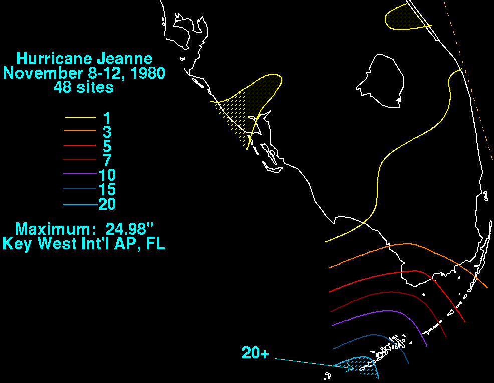 The combination of a large high pressure system and Jeanne produced rough seas over the northern Gulf of Mexico; wave heights reached 15 feet (4.60 m). On November 11, a ship reported sustained winds of 110 mph (175 km/h), although this reading was discarded and attributed to intense squalls. In Key West, the storm's outer fringes produced a record-breaking 24-hour rainfall total of 23.28 inches (591 mm); 13.58 inches (345 mm) fell within six hours. It remains the record 24-hour November rainfall total for the city as of 2007. The previous record was set in 1954. The heavy precipitation was attributed to a mesoscale feature
; an inflow band intersected with an adjacent stationary front, which also contributed to the deluge. Schools and most businesses were closed, while flights were grounded at Key West International Airport
; authorities urged residents to stay home. Telephone and power services were cut to some areas of the city.
Elsewhere, several ships were caught off guard by the late arrival of Jeanne. The cyclone entered the Gulf of Mexico, and two barges broke loose from towing vessels via strong winds and high waves. One barge was an oil rig tender that contained 16 people; it was carried several hundred miles across the central Gulf of Mexico. All crew members survived, and there were no maritime deaths related to the hurricane. Jeanne produced a prolonged period of rough surf and heavy swells along the Texas coast. Tides reached 2 to 4 feet (1.20 m) above normal. The hurricane caused coastal flooding; the worst flooding occurred near Galveston
.
Jeanne was one of only four tropical cyclones in the 20th century to attain hurricane status in the Gulf of Mexico without making landfall
; the others were Laurie of 1969, Henri of 1979, and Alberto of 1982
.
Tropical cyclone
A tropical cyclone is a storm system characterized by a large low-pressure center and numerous thunderstorms that produce strong winds and heavy rain. Tropical cyclones strengthen when water evaporated from the ocean is released as the saturated air rises, resulting in condensation of water vapor...
and eighth hurricane
Atlantic hurricane
North Atlantic tropical cyclones usually form in the northern hemisphere summer or fall. Tropical cyclones can be categorized by intensity. Tropical storms have one-minute maximum sustained winds of at least 39 mph , while hurricanes have one-minute maximum sustained exceeding 74 mph...
of the 1980 Atlantic hurricane season, Jeanne developed over the southern Caribbean
Caribbean
The Caribbean is a crescent-shaped group of islands more than 2,000 miles long separating the Gulf of Mexico and the Caribbean Sea, to the west and south, from the Atlantic Ocean, to the east and north...
on November 7. It moved swiftly northward, and it intensified to a tropical storm on November 9. It entered the southern Gulf of Mexico on November 10. Jeanne turned to the west on November 11, and it rapidly intensified to its peak intensity of 100 mph (155 km/h). It weakened on November 12, and its forward motion slowed; the cyclone weakened further to a tropical storm because of dry air intrusion, and it executed a clockwise loop on November 15. It dissipated on November 16.
At the time, Jeanne was one of three November hurricanes in the Gulf of Mexico; it was the first tropical cyclone to attain hurricane strength in the Gulf of Mexico during November. The late season storm surprised maritime interests, and two barges broke free from towing vessels. Indirectly, the hurricane produced heavy precipitation that peaked at 23.28 inches (591 mm) in Key West
Key West, Florida
Key West is a city in Monroe County, Florida, United States. The city encompasses the island of Key West, the part of Stock Island north of U.S. 1 , Sigsbee Park , Fleming Key , and Sunset Key...
. Minor beach erosion occurred along the Texas coast, where tides were two to four feet above normal; coastal flooding affected the state, which was heavily impacted by tropical cyclones in August and September. Jeanne caused no deaths.
Meteorological history
On the late afternoon of November 7, an area of disturbed weather organized to a tropical depression 60 miles (100 km) east of Atlántico NorteRegión Autónoma del Atlántico Norte
Región Autónoma del Atlántico Norte , sometimes shortened to RAAN, is one of two autonomous regions in Nicaragua. It covers an area of 32,159 km² and has a population of 249,700 . It is the largest autonomous region or department in Nicaragua...
, Nicaragua
Nicaragua
Nicaragua is the largest country in the Central American American isthmus, bordered by Honduras to the north and Costa Rica to the south. The country is situated between 11 and 14 degrees north of the Equator in the Northern Hemisphere, which places it entirely within the tropics. The Pacific Ocean...
. Its origins were traced to a tropical wave that originated over western Africa on October 26. Atmospheric conditions resembled an early fall pattern, and a large ridge
Ridge (meteorology)
A ridge is an elongated region of relatively high atmospheric pressure, the opposite of a trough....
was situated over the Gulf of Mexico and Southwestern United States
Southwestern United States
The Southwestern United States is a region defined in different ways by different sources. Broad definitions include nearly a quarter of the United States, including Arizona, California, Colorado, Nevada, New Mexico, Oklahoma, Texas and Utah...
. The depression moved northward into the Caribbean Sea, and the environment supported further development. On November 9, the depression strengthened to a 40 mph (65 km/h) tropical storm. Later, an Air Force reconnaissance aircraft
Hurricane Hunters
The Hurricane Hunters are aircraft that fly into tropical cyclones in the North Atlantic Ocean and Northeastern Pacific Ocean for the specific purpose of directly measuring weather data in and around those storms. In the United States, the Air Force, Navy, and NOAA units have all participated in...
reported a strengthening system; maximum sustained winds increased to 50 mph (80 km/h), and a minimum pressure of 999 mbar
Bar (unit)
The bar is a unit of pressure equal to 100 kilopascals, and roughly equal to the atmospheric pressure on Earth at sea level. Other units derived from the bar are the megabar , kilobar , decibar , centibar , and millibar...
was measured. The tropical cyclone moved northward into the southern Gulf of Mexico on November 10. Jeanne's northward movement was blocked by the ridge, and the cyclone slowly turned to the west. On November 11, Jeanne quickly intensified to a minimal hurricane; later, it attained its peak intensity of 100 mph (155 km/h).
On November 12, Jeanne weakened to a Category 1 hurricane
Saffir-Simpson Hurricane Scale
The Saffir–Simpson Hurricane Scale , or the Saffir–Simpson Hurricane Wind Scale , classifies hurricanes — Western Hemisphere tropical cyclones that exceed the intensities of tropical depressions and tropical storms — into five categories distinguished by the intensities of their sustained winds...
. It entered the western Gulf of Mexico, and its forward motion diminished as the ridge moved east. Later, Jeanne diminished to a 65 mph (105 km/h) tropical storm. A developing trough
Trough (meteorology)
A trough is an elongated region of relatively low atmospheric pressure, often associated with fronts.Unlike fronts, there is not a universal symbol for a trough on a weather chart. The weather charts in some countries or regions mark troughs by a line. In the United States, a trough may be marked...
remained west of Jeanne, and the cyclone was embedded in a weak pressure gradient. Although Jeanne briefly re-intensified to 70 mph (110 km/h), an advancing frontal boundary
Weather front
A weather front is a boundary separating two masses of air of different densities, and is the principal cause of meteorological phenomena. In surface weather analyses, fronts are depicted using various colored lines and symbols, depending on the type of front...
brought dry air over the western Gulf of Mexico. Jeanne weakened to a depression on November 14. It executed a clockwise loop, and it merged with the frontal boundary on November 16.
Preparations
Some residents on Dauphin IslandDauphin Island, Alabama
Dauphin Island is a town in Mobile County, Alabama , on a barrier island also named Dauphin Island , at the Gulf of Mexico. The population was 1,371 at the 2000 census. The town is included in the Mobile metropolitan statistical area...
voluntarily evacuated, spurred by memories of 1979's Hurricane Frederic
Hurricane Frederic
Hurricane Frederic was the sixth tropical cyclone, third hurricane and second major hurricane of the 1979 Atlantic hurricane season. Frederic was the costliest hurricane to ever hit the U.S. Gulf Coast at that particular time...
and Jeanne's northward motion. 3,000 workers evacuated their oil rigs because of Jeanne's high waves. The National Hurricane Center
National Hurricane Center
The National Hurricane Center , located at Florida International University in Miami, Florida, is the division of the National Weather Service responsible for tracking and predicting weather systems within the tropics between the Prime Meridian and the 140th meridian west poleward to the 30th...
advised small watercraft to remain in ports from Brownsville
Brownsville, Texas
Brownsville is a city in the southernmost tip of the state of Texas, in the United States. It is located on the northern bank of the Rio Grande, directly north and across the border from Matamoros, Tamaulipas, Mexico. Brownsville is the 16th largest city in the state of Texas with a population of...
to Tarpon Springs
Tarpon Springs, Florida
Tarpon Springs is a city in Pinellas County, Florida, United States. The population was 21,003 at the 2000 census. According to the U.S. Census Bureau's 2004 estimates, the city had a population of 22,554....
. Forecasters expected tides of 2 feet above normal in Louisiana
Louisiana
Louisiana is a state located in the southern region of the United States of America. Its capital is Baton Rouge and largest city is New Orleans. Louisiana is the only state in the U.S. with political subdivisions termed parishes, which are local governments equivalent to counties...
, which increased to 4 feet above normal along coastal Texas
Texas
Texas is the second largest U.S. state by both area and population, and the largest state by area in the contiguous United States.The name, based on the Caddo word "Tejas" meaning "friends" or "allies", was applied by the Spanish to the Caddo themselves and to the region of their settlement in...
. In Terrebonne
Terrebonne Parish, Louisiana
Terrebonne Parish is a parish located in the U.S. state of Louisiana. The parish seat is Houma. Its population was 111,860...
and Lafourche
Lafourche Parish, Louisiana
Lafourche Parish is a parish located in the south of the U.S. state of Louisiana. It was originally the northern part of Lafourche Interior Parish, which consisted of the present parishes of Lafourche and Terrebonne. The parish seat is Thibodaux...
parishes, schools were closed because of uncertainties regarding Jeanne's path. The hurricane center also expected Jeanne to make landfall in southwestern Louisiana, although the hurricane eventually stayed offshore; thousands of residents moved inland, while Civil Defense officials remained alert. Forecasters expected locally heavy rainfall, although they suggested it would remain below 8 inches (203 mm).
Impact
Mesoscale meteorology
Mesoscale meteorology is the study of weather systems smaller than synoptic scale systems but larger than microscale and storm-scale cumulus systems. Horizontal dimensions generally range from around 5 kilometers to several hundred kilometers...
; an inflow band intersected with an adjacent stationary front, which also contributed to the deluge. Schools and most businesses were closed, while flights were grounded at Key West International Airport
Key West International Airport
Key West International Airport is a county-owned public airport located two miles east of the central business district of Key West, in Monroe County, Florida, United States....
; authorities urged residents to stay home. Telephone and power services were cut to some areas of the city.
Elsewhere, several ships were caught off guard by the late arrival of Jeanne. The cyclone entered the Gulf of Mexico, and two barges broke loose from towing vessels via strong winds and high waves. One barge was an oil rig tender that contained 16 people; it was carried several hundred miles across the central Gulf of Mexico. All crew members survived, and there were no maritime deaths related to the hurricane. Jeanne produced a prolonged period of rough surf and heavy swells along the Texas coast. Tides reached 2 to 4 feet (1.20 m) above normal. The hurricane caused coastal flooding; the worst flooding occurred near Galveston
Galveston, Texas
Galveston is a coastal city located on Galveston Island in the U.S. state of Texas. , the city had a total population of 47,743 within an area of...
.
Jeanne was one of only four tropical cyclones in the 20th century to attain hurricane status in the Gulf of Mexico without making landfall
Landfall (meteorology)
Landfall is the event of a tropical cyclone or a waterspout coming onto land after being over water. When a waterspout makes landfall it is reclassified as a tornado, which can then cause damage inland...
; the others were Laurie of 1969, Henri of 1979, and Alberto of 1982
Hurricane Alberto (1982)
Hurricane Alberto caused the worst flooding in western Cuba in 32 years. The first tropical storm and hurricane of the 1982 Atlantic hurricane season, Alberto developed from a tropical disturbance on June 2 in the southern Gulf of Mexico...
.
See also
- List of Texas hurricanes
- Other storms of the same nameTropical Storm JeanneThe name Jeanne was used for three tropical cyclones in the Atlantic Ocean.* 1980's Hurricane Jeanne - a rare November hurricane in the Gulf of Mexico that caused no significant damage....