
.gif)
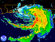
Tropical Storm Beryl (1994)
Encyclopedia
Tropical Storm Beryl, was the second named storm of the 1994 Atlantic hurricane season
. Beryl originated north of Puerto Rico
as an upper-level low pressure system, then passed over Florida, then entered the gulf where it became a tropical depression. The storm had advisories on it for five days; its winds peaked at 60 mi/h before dissipating over the Northeast United States. Beryl caused $73 million (1994 USD) in damage, over the eastern portion of the United States. Most of the damage was from tornadoes or flooding from the tropical storm. Beryl caused moderate to minor injuries, and 1 death.
 A large upper-level low pressure area developed over the southeastern Atlantic Ocean
that was situated to the north of Puerto Rico
on August 9. The disturbance moved westward, and despite weakening to a trough
in the upper levels of the atmosphere, there was evidence of a low- to mid-level circulation off the southwest coast of Florida
on August 12. The next day, surface observations and ship reports suggested the presence of a weak 1014 mb surface
low pressure system. Moving towards the north-northwest, a cloud-pattern was identified on satellite imagery, and Dvorak estimates
were initiated at 0000 UTC on August 14. Based on data from surface observations, satellite imagery, and information from reconnaissance
aircraft, the system is estimated to have become a tropical depression at 1200 UTC on August 14; at the time, the depression was located approximately 120 miles (193.1 km) south of Pensacola, Florida
.
The depression drifted slowly towards the north after being designated, while its poorly-defined center of circulation was organizing. Between 1630 and 2011 UTC on August 14, the system was nearly stationary; a few hours later, there were indications that the storm's center reformed to the east of its original location. The depression tracked slowly towards the east-northeast while producing rainfall throughout portions of Florida. Becoming better organized, the depression strengthened into Tropical Storm Beryl on August 15. Possibly influenced by a mesoscale
featured noted to the south of Beryl's circulation, the center of circulation began moving erratically after being upgraded. However in response to an approaching trough, the storm turned towards the north and made landfall near Panama City, Florida
at 0000 UTC on August 16. Offshore winds generated coastal flooding along portions of the coast, and even after the storm moved inland, high winds were reported in the Apalachee Bay
area.
About 12 hours after moving ashore, Beryl weakened to a tropical depression. With increasing forward motion, the depression continued towards the north-northeast. By 1800 UTC the depression was situated to the south of Atlanta, Georgia
; slowly weakening, the storm's remnants were identified near Asheville, North Carolina
early on August 17. While located over Maryland
, rainfall associated with the low extended into the Mid-Atlantic
, New York
, and New England
. The system also maintained rainband
s accompanied by thunderstorm
s and heavy rainfall. Throughout the East Coast, the system spawned heavy precipitation and tornado
es. The low continued to track northeastward; after passing through Connecticut
, the low was absorbed into a frontal trough
on August 19.
to Cedar Key
on August 15. Later that day, the watch was replaced with a tropical storm warning that extended from Fort Walton Beach, Florida
to Yankeetown, Florida
. The warning was discontinued for areas west of Apalachicola, Florida
, and by 1200 UTC on August 16, all tropical cyclone warnings and watches
were lifted. Initially, the public advisories issued by the National Hurricane Center
on the storm warned primarily of heavy rain, as Beryl was expected to remain a weak cyclone. However, when the storm slowed in forward motion and the potential for intensification increased, the advisories emphasized the potential for coastal flooding. Tornado watch
es were issued for parts of Florida. Flash flood watch
es and warnings
were also declared for parts of the state.
Flash flood watches, warnings, and tornado watches were posted for portions of Georgia
as Beryl progressed inland. Flash flood watches and warnings were also initiated throughout parts of South Carolina
, North Carolina
, Virginia
, West Virginia
, and Maryland
. A tornado watch was declared for central and eastern North Carolina on August 17; similar advisories were placed into effect over parts of New Jersey
, Delaware
, Maryland, and Virginia. Flash flood advisories were also issued northward into New York
.
 Tropical Storm Beryl was a weak system, and unlike Alberto, its rapid motion up the Eastern Seaboard
spread its heavy rainfall across a large area. Beryl caused inland flooding as it moved through Georgia, across the Carolinas, and all the way to Connecticut. Property damage was estimated at $73 million (1994 USD
). 5.9 million dollars of damage was in Florida, 40 million in South Carolina, 15 million in Virginia, and 12 million in New York
, with other states likely having smaller totals. Although there were no deaths caused by Beryl, a large number of people were injured by the 37 tornadoes Beryl produced as it weakened.
could not be harvested in the prime winter of 1994, due to runoff from the sediment of rivers, from 9 inches (228.6 mm) of rain. In addition, rainfall from Tropical Storm Alberto
earlier in the season and Beryl caused nearly 30 inches (762 mm) of rain in some areas of the Florida Panhandle
, in the span of barely more than a month.
Offshore of Florida, tides of 3 to 5 feet (1.5 m) were reported.
No deaths or serious injuries were reported in Florida, although damage from Beryl was estimated at $5.9 million (1994 USD; $ USD). Residents also reported that there was high wind in their areas.
said that roads were flooded, but passable by cars. She also said that "we really don't have anything that's blown out as far as bridges and culverts, but we do have a lot of trees down." A tornado was reported east of Athens
, that destroyed a house and a shop. However, no injuries were reported.
10 inches of rain fell in 24 hours across North Carolina and South Carolina. A total estimated $37 million (1994 USD) in damage resulted from thunderstorms and tornadoes. Several tornadoes also were reported across South Carolina, from rainbands from Beryl. Several tornadoes resulted from the hurricane in Lexington
, South Carolina, just west of Columbia
. The Village Center shopping center caved in, as a result of an F3 tornado, which resulted in 35 people being injured, none seriously, and two people missing initially. 25 people were taken to Lexington Medical Center, mostly for cuts, bruises, and broken or dislocated bones. 40 to 50 buildings in total, were damaged or destroyed. The F3 tornado went across 5 miles (8 km), until it reached Lake Murray
. The damage path was a quarter mile wide and caused widespread destruction of buildings and homes. Another F3 tornado touched down 4 miles (6.4 km) south of Lexington, where it completely leveled a square stick frame home. Three other tornadoes touched down in Lexington County. An F1 tornado touched down from 11:09 to 11:30 AM local time, in a rural area, was 75 yards (68.6 m) wide, and its path was 5 miles (8 km) long. It overturned a mobile home at the intersection of highways 64 and 301, causing one serious injury. At the WSFO, Weather Bureau, a significant failure of the WSR-88D at the RFA occurred from 1:17 to 1:39 PM local time
. This caused the weather bureau to miss a tornado that downed in southwest Richland County
at 1:30 local time, even though the emergency technicians tried to quickly respond to the problem. The WSR-74C was used as a backup, but didn't detect the tornado that touched down.
. Creeks in the region rose to elevated levels, and flooding of roads, yards, and basements was reported.
State, peaking at 4.28 inches (108.7 mm). The precipitation led to flash flood
ing in the Susquehanna
and western Catskills regions of the state. Numerous streams and rivers overflowed their banks, resulting in extensive flood damage. Tioga
, Steuben
, and Chemung
counties were the hardest hit areas. In Chemung County, damage from the storm is estimated at $5 million (1994 USD), over half of which was within the town of Southport
. Several bridges and over 25 homes were damaged; between 60 and 70 residents in the county were forced to evacuate. Beryl's remnants inflicted $650,000 (1994 USD) in municipal damage to Steuben County, where one man was rescued from flood waters by a local fire department. Tioga County received $1.5 million (1994 USD) in damage; a woman in the town of Tioga
drowned after attempted to leave her stranded vehicle. Flood waters entered the Waverly
town hall, in addition to several businesses. Some town records were damaged, although they were saved with freeze-drying. At least 14 homes were damaged in Otsego County
; seven highways sustained severe damage, including portions of New York State Route 7
, which was forced to close for several hours. Elsewhere in the state, flood waters reached 2 to 3 ft (0.6096 to 0.9144 m) in some locations, with roads and basements throughout the region flooded. Damage in New York totaled $12 million (1994 USD).
Light to moderate rainfall extended into much of southern and central New England
, particularly throughout portions of Connecticut and Massachusetts
. The precipitation peaked at 5.39 inches (136.9 mm) at West Hartford, Connecticut
.
1994 Atlantic hurricane season
The 1994 Atlantic hurricane seasonofficially began June 1, 1994, and officially ended November 30, 1994. These dates conventionally delimit the period of each year when most tropical cyclones form in the Atlantic basin....
. Beryl originated north of Puerto Rico
Puerto Rico
Puerto Rico , officially the Commonwealth of Puerto Rico , is an unincorporated territory of the United States, located in the northeastern Caribbean, east of the Dominican Republic and west of both the United States Virgin Islands and the British Virgin Islands.Puerto Rico comprises an...
as an upper-level low pressure system, then passed over Florida, then entered the gulf where it became a tropical depression. The storm had advisories on it for five days; its winds peaked at 60 mi/h before dissipating over the Northeast United States. Beryl caused $73 million (1994 USD) in damage, over the eastern portion of the United States. Most of the damage was from tornadoes or flooding from the tropical storm. Beryl caused moderate to minor injuries, and 1 death.
Meteorological history
Atlantic Ocean
The Atlantic Ocean is the second-largest of the world's oceanic divisions. With a total area of about , it covers approximately 20% of the Earth's surface and about 26% of its water surface area...
that was situated to the north of Puerto Rico
Puerto Rico
Puerto Rico , officially the Commonwealth of Puerto Rico , is an unincorporated territory of the United States, located in the northeastern Caribbean, east of the Dominican Republic and west of both the United States Virgin Islands and the British Virgin Islands.Puerto Rico comprises an...
on August 9. The disturbance moved westward, and despite weakening to a trough
Trough (meteorology)
A trough is an elongated region of relatively low atmospheric pressure, often associated with fronts.Unlike fronts, there is not a universal symbol for a trough on a weather chart. The weather charts in some countries or regions mark troughs by a line. In the United States, a trough may be marked...
in the upper levels of the atmosphere, there was evidence of a low- to mid-level circulation off the southwest coast of Florida
Florida
Florida is a state in the southeastern United States, located on the nation's Atlantic and Gulf coasts. It is bordered to the west by the Gulf of Mexico, to the north by Alabama and Georgia and to the east by the Atlantic Ocean. With a population of 18,801,310 as measured by the 2010 census, it...
on August 12. The next day, surface observations and ship reports suggested the presence of a weak 1014 mb surface
Surface weather analysis
Surface weather analysis is a special type of weather map that provides a view of weather elements over a geographical area at a specified time based on information from ground-based weather stations...
low pressure system. Moving towards the north-northwest, a cloud-pattern was identified on satellite imagery, and Dvorak estimates
Dvorak technique
The Dvorak technique is a widely used system to subjectively estimate tropical cyclone intensity based solely on visible and infrared satellite images. Several agencies issue Dvorak intensity numbers for cyclones of sufficient intensity...
were initiated at 0000 UTC on August 14. Based on data from surface observations, satellite imagery, and information from reconnaissance
Reconnaissance
Reconnaissance is the military term for exploring beyond the area occupied by friendly forces to gain information about enemy forces or features of the environment....
aircraft, the system is estimated to have become a tropical depression at 1200 UTC on August 14; at the time, the depression was located approximately 120 miles (193.1 km) south of Pensacola, Florida
Pensacola, Florida
Pensacola is the westernmost city in the Florida Panhandle and the county seat of Escambia County, Florida, United States of America. As of the 2000 census, the city had a total population of 56,255 and as of 2009, the estimated population was 53,752...
.
The depression drifted slowly towards the north after being designated, while its poorly-defined center of circulation was organizing. Between 1630 and 2011 UTC on August 14, the system was nearly stationary; a few hours later, there were indications that the storm's center reformed to the east of its original location. The depression tracked slowly towards the east-northeast while producing rainfall throughout portions of Florida. Becoming better organized, the depression strengthened into Tropical Storm Beryl on August 15. Possibly influenced by a mesoscale
Mesoscale meteorology
Mesoscale meteorology is the study of weather systems smaller than synoptic scale systems but larger than microscale and storm-scale cumulus systems. Horizontal dimensions generally range from around 5 kilometers to several hundred kilometers...
featured noted to the south of Beryl's circulation, the center of circulation began moving erratically after being upgraded. However in response to an approaching trough, the storm turned towards the north and made landfall near Panama City, Florida
Panama City, Florida
-Personal income:The median income for a household in the city was $31,572, and the median income for a family was $40,890. Males had a median income of $30,401 versus $21,431 for females. The per capita income for the city was $17,830...
at 0000 UTC on August 16. Offshore winds generated coastal flooding along portions of the coast, and even after the storm moved inland, high winds were reported in the Apalachee Bay
Apalachee Bay
Apalachee Bay is a bay in the northeastern Gulf of Mexico occupying an indentation of the Florida coast to the west of where the Florida peninsula joins the United States mainland. It is bordered by Taylor, Jefferson, Wakulla and Franklin counties. The Aucilla, Econfina, St. Marks and Ochlocknee...
area.
About 12 hours after moving ashore, Beryl weakened to a tropical depression. With increasing forward motion, the depression continued towards the north-northeast. By 1800 UTC the depression was situated to the south of Atlanta, Georgia
Atlanta, Georgia
Atlanta is the capital and most populous city in the U.S. state of Georgia. According to the 2010 census, Atlanta's population is 420,003. Atlanta is the cultural and economic center of the Atlanta metropolitan area, which is home to 5,268,860 people and is the ninth largest metropolitan area in...
; slowly weakening, the storm's remnants were identified near Asheville, North Carolina
Asheville, North Carolina
Asheville is a city in and the county seat of Buncombe County, North Carolina, United States. It is the largest city in Western North Carolina, and the 11th largest city in North Carolina. The City is home to the United States National Climatic Data Center , which is the world's largest active...
early on August 17. While located over Maryland
Maryland
Maryland is a U.S. state located in the Mid Atlantic region of the United States, bordering Virginia, West Virginia, and the District of Columbia to its south and west; Pennsylvania to its north; and Delaware to its east...
, rainfall associated with the low extended into the Mid-Atlantic
Mid-Atlantic States
The Mid-Atlantic states, also called middle Atlantic states or simply the mid Atlantic, form a region of the United States generally located between New England and the South...
, New York
New York
New York is a state in the Northeastern region of the United States. It is the nation's third most populous state. New York is bordered by New Jersey and Pennsylvania to the south, and by Connecticut, Massachusetts and Vermont to the east...
, and New England
New England
New England is a region in the northeastern corner of the United States consisting of the six states of Maine, New Hampshire, Vermont, Massachusetts, Rhode Island, and Connecticut...
. The system also maintained rainband
Rainband
A rainband is a cloud and precipitation structure associated with an area of rainfall which is significantly elongated. Rainbands can be stratiform or convective, and are generated by differences in temperature. When noted on weather radar imagery, this precipitation elongation is referred to as...
s accompanied by thunderstorm
Thunderstorm
A thunderstorm, also known as an electrical storm, a lightning storm, thundershower or simply a storm is a form of weather characterized by the presence of lightning and its acoustic effect on the Earth's atmosphere known as thunder. The meteorologically assigned cloud type associated with the...
s and heavy rainfall. Throughout the East Coast, the system spawned heavy precipitation and tornado
Tornado
A tornado is a violent, dangerous, rotating column of air that is in contact with both the surface of the earth and a cumulonimbus cloud or, in rare cases, the base of a cumulus cloud. They are often referred to as a twister or a cyclone, although the word cyclone is used in meteorology in a wider...
es. The low continued to track northeastward; after passing through Connecticut
Connecticut
Connecticut is a state in the New England region of the northeastern United States. It is bordered by Rhode Island to the east, Massachusetts to the north, and the state of New York to the west and the south .Connecticut is named for the Connecticut River, the major U.S. river that approximately...
, the low was absorbed into a frontal trough
Weather front
A weather front is a boundary separating two masses of air of different densities, and is the principal cause of meteorological phenomena. In surface weather analyses, fronts are depicted using various colored lines and symbols, depending on the type of front...
on August 19.
Preparations
In advance of the storm, a tropical storm watch was posted from Pensacola, FloridaPensacola, Florida
Pensacola is the westernmost city in the Florida Panhandle and the county seat of Escambia County, Florida, United States of America. As of the 2000 census, the city had a total population of 56,255 and as of 2009, the estimated population was 53,752...
to Cedar Key
Cedar Key, Florida
Cedar Key is a city in Levy County, Florida, United States. The population was 790 at the 2000 census. According to the U.S Census estimates of 2005, the city had a population of 958. The Cedar Keys are a cluster of islands close to the mainland. Most of the developed area of the city has been on...
on August 15. Later that day, the watch was replaced with a tropical storm warning that extended from Fort Walton Beach, Florida
Fort Walton Beach, Florida
Fort Walton Beach is a city in southern Okaloosa County, Florida, United States. As of 2005, the population estimate for Fort Walton Beach was 19,992, and as of 2010, the population estimate for Fort Walton Beach is 19,507 recorded by the U.S. Census Bureau...
to Yankeetown, Florida
Yankeetown, Florida
Yankeetown is a town in Levy County, Florida, United States. The population was 629 at the 2000 census. According to the U.S. Census Bureau's 2004 estimates, the town had a population of 672.-History:...
. The warning was discontinued for areas west of Apalachicola, Florida
Apalachicola, Florida
Apalachicola is a city in Franklin County, Florida, on US 98 about southwest of Tallahassee. The population was 2,334 at the 2000 census. The 2005 census estimated the city's population at 2,340...
, and by 1200 UTC on August 16, all tropical cyclone warnings and watches
Tropical cyclone warnings and watches
Warnings and watches are two levels of alert issued by national weather forecasting bodies to coastal areas threatened by the imminent approach of a tropical cyclone of tropical storm or hurricane intensity. They are notices to the local population and civil authorities to make appropriate...
were lifted. Initially, the public advisories issued by the National Hurricane Center
National Hurricane Center
The National Hurricane Center , located at Florida International University in Miami, Florida, is the division of the National Weather Service responsible for tracking and predicting weather systems within the tropics between the Prime Meridian and the 140th meridian west poleward to the 30th...
on the storm warned primarily of heavy rain, as Beryl was expected to remain a weak cyclone. However, when the storm slowed in forward motion and the potential for intensification increased, the advisories emphasized the potential for coastal flooding. Tornado watch
Tornado watch
A tornado watch is issued when conditions are right for a tornado to form. Since any thunderstorm capable of producing a tornado is defined as severe, a tornado watch is also automatically a severe thunderstorm watch...
es were issued for parts of Florida. Flash flood watch
Flash flood watch
A Flash flood watch is issued by the National Weather Service when conditions are favorable for flash flooding in flood-prone areas where grounds are already saturated from recent rains....
es and warnings
Flash Flood Warning
A Flash Flood Warning is issued when a flash flood is imminent or occurring in the warned area. A flash flood is a sudden, violent flood after a heavy rain...
were also declared for parts of the state.
Flash flood watches, warnings, and tornado watches were posted for portions of Georgia
Georgia (U.S. state)
Georgia is a state located in the southeastern United States. It was established in 1732, the last of the original Thirteen Colonies. The state is named after King George II of Great Britain. Georgia was the fourth state to ratify the United States Constitution, on January 2, 1788...
as Beryl progressed inland. Flash flood watches and warnings were also initiated throughout parts of South Carolina
South Carolina
South Carolina is a state in the Deep South of the United States that borders Georgia to the south, North Carolina to the north, and the Atlantic Ocean to the east. Originally part of the Province of Carolina, the Province of South Carolina was one of the 13 colonies that declared independence...
, North Carolina
North Carolina
North Carolina is a state located in the southeastern United States. The state borders South Carolina and Georgia to the south, Tennessee to the west and Virginia to the north. North Carolina contains 100 counties. Its capital is Raleigh, and its largest city is Charlotte...
, Virginia
Virginia
The Commonwealth of Virginia , is a U.S. state on the Atlantic Coast of the Southern United States. Virginia is nicknamed the "Old Dominion" and sometimes the "Mother of Presidents" after the eight U.S. presidents born there...
, West Virginia
West Virginia
West Virginia is a state in the Appalachian and Southeastern regions of the United States, bordered by Virginia to the southeast, Kentucky to the southwest, Ohio to the northwest, Pennsylvania to the northeast and Maryland to the east...
, and Maryland
Maryland
Maryland is a U.S. state located in the Mid Atlantic region of the United States, bordering Virginia, West Virginia, and the District of Columbia to its south and west; Pennsylvania to its north; and Delaware to its east...
. A tornado watch was declared for central and eastern North Carolina on August 17; similar advisories were placed into effect over parts of New Jersey
New Jersey
New Jersey is a state in the Northeastern and Middle Atlantic regions of the United States. , its population was 8,791,894. It is bordered on the north and east by the state of New York, on the southeast and south by the Atlantic Ocean, on the west by Pennsylvania and on the southwest by Delaware...
, Delaware
Delaware
Delaware is a U.S. state located on the Atlantic Coast in the Mid-Atlantic region of the United States. It is bordered to the south and west by Maryland, and to the north by Pennsylvania...
, Maryland, and Virginia. Flash flood advisories were also issued northward into New York
New York
New York is a state in the Northeastern region of the United States. It is the nation's third most populous state. New York is bordered by New Jersey and Pennsylvania to the south, and by Connecticut, Massachusetts and Vermont to the east...
.
Impact
Eastern seaboard
An Eastern seaboard can mean any easternmost part of a continent, or its countries, states and/or cities.Eastern seaboard may also refer to:* East Coast of Australia* East Coast of the United States* Eastern Seaboard of Thailand-See also:...
spread its heavy rainfall across a large area. Beryl caused inland flooding as it moved through Georgia, across the Carolinas, and all the way to Connecticut. Property damage was estimated at $73 million (1994 USD
United States dollar
The United States dollar , also referred to as the American dollar, is the official currency of the United States of America. It is divided into 100 smaller units called cents or pennies....
). 5.9 million dollars of damage was in Florida, 40 million in South Carolina, 15 million in Virginia, and 12 million in New York
New York
New York is a state in the Northeastern region of the United States. It is the nation's third most populous state. New York is bordered by New Jersey and Pennsylvania to the south, and by Connecticut, Massachusetts and Vermont to the east...
, with other states likely having smaller totals. Although there were no deaths caused by Beryl, a large number of people were injured by the 37 tornadoes Beryl produced as it weakened.
Florida
Oysters in the Apalachicola BayApalachicola Bay
Apalachicola Bay is an estuary and lagoon located on Florida's northwest coast renowned for its oysters. The Apalachicola Bay system also includes St. Georges Sound, St. Vincent Sound and East Bay, covering an area of about . Four islands St. Vincent Island to the west, Cape St. George Island and St...
could not be harvested in the prime winter of 1994, due to runoff from the sediment of rivers, from 9 inches (228.6 mm) of rain. In addition, rainfall from Tropical Storm Alberto
Tropical Storm Alberto (1994)
Tropical Storm Alberto was the first storm of the 1994 Atlantic hurricane season. It hit Florida across the Southeast United States in July, causing a massive flooding disaster while stalling over Georgia and Alabama. Alberto caused $1 billion in damage and 30 deaths.-Meteorological history:A...
earlier in the season and Beryl caused nearly 30 inches (762 mm) of rain in some areas of the Florida Panhandle
Florida Panhandle
The Florida Panhandle, an informal, unofficial term for the northwestern part of Florida, is a strip of land roughly 200 miles long and 50 to 100 miles wide , lying between Alabama on the north and the west, Georgia also on the north, and the Gulf of Mexico to the south. Its eastern boundary is...
, in the span of barely more than a month.
Offshore of Florida, tides of 3 to 5 feet (1.5 m) were reported.
No deaths or serious injuries were reported in Florida, although damage from Beryl was estimated at $5.9 million (1994 USD; $ USD). Residents also reported that there was high wind in their areas.
Georgia and the Carolinas
10 inches of rain fell in 24 hours, across Georgia. A confirmed report of 13.59 inches (345.2 mm) occurred in Tallulah Falls in northeast Georgia. A spokesman for Thomas CountyThomas County, Georgia
Thomas County is a county located in the U.S. state of Georgia. The 2010 Census showed a population of 44,720. The county seat is Thomasville.-History:...
said that roads were flooded, but passable by cars. She also said that "we really don't have anything that's blown out as far as bridges and culverts, but we do have a lot of trees down." A tornado was reported east of Athens
Athens, Georgia
Athens-Clarke County is a consolidated city–county in U.S. state of Georgia, in the northeastern part of the state, comprising the former City of Athens proper and Clarke County. The University of Georgia is located in this college town and is responsible for the initial growth of the city...
, that destroyed a house and a shop. However, no injuries were reported.
10 inches of rain fell in 24 hours across North Carolina and South Carolina. A total estimated $37 million (1994 USD) in damage resulted from thunderstorms and tornadoes. Several tornadoes also were reported across South Carolina, from rainbands from Beryl. Several tornadoes resulted from the hurricane in Lexington
Lexington, South Carolina
Lexington is a town in and the county seat of Lexington County, South Carolina, United States. The population was 17,870 at the 2010 census.-Geography:Lexington is located at ....
, South Carolina, just west of Columbia
Columbia, South Carolina
Columbia is the state capital and largest city in the U.S. state of South Carolina. The population was 129,272 according to the 2010 census. Columbia is the county seat of Richland County, but a portion of the city extends into neighboring Lexington County. The city is the center of a metropolitan...
. The Village Center shopping center caved in, as a result of an F3 tornado, which resulted in 35 people being injured, none seriously, and two people missing initially. 25 people were taken to Lexington Medical Center, mostly for cuts, bruises, and broken or dislocated bones. 40 to 50 buildings in total, were damaged or destroyed. The F3 tornado went across 5 miles (8 km), until it reached Lake Murray
Lake Murray (South Carolina)
Lake Murray is a reservoir in the U.S. state of South Carolina. It is approximately 50,000 acres in size, and has roughly 500 miles of shoreline. It was impounded in the late 1920s to provide hydroelectric power to the state of South Carolina. Lake Murray is fed by the Saluda River, which flows...
. The damage path was a quarter mile wide and caused widespread destruction of buildings and homes. Another F3 tornado touched down 4 miles (6.4 km) south of Lexington, where it completely leveled a square stick frame home. Three other tornadoes touched down in Lexington County. An F1 tornado touched down from 11:09 to 11:30 AM local time, in a rural area, was 75 yards (68.6 m) wide, and its path was 5 miles (8 km) long. It overturned a mobile home at the intersection of highways 64 and 301, causing one serious injury. At the WSFO, Weather Bureau, a significant failure of the WSR-88D at the RFA occurred from 1:17 to 1:39 PM local time
North American Eastern Time Zone
The Eastern Time Zone of the United States and Canada is a time zone that falls mostly along the east coast of North America. Its UTC time offset is −5 hrs during standard time and −4 hrs during daylight saving time...
. This caused the weather bureau to miss a tornado that downed in southwest Richland County
Richland County, South Carolina
Richland County is a county located in the U.S. state of South Carolina. The 2000 U.S. census recorded its population to be 320,677. In 2010, the U.S. Census Bureau recorded that its population had reached 384,504. It is the second most populous county in South Carolina, behind only Greenville...
at 1:30 local time, even though the emergency technicians tried to quickly respond to the problem. The WSR-74C was used as a backup, but didn't detect the tornado that touched down.
Mid-Atlantic
Thunderstorms associated with Beryl's remnants dropped 3 to 5 in (76.2 to 127 mm) of rainfall in parts of MarylandMaryland
Maryland is a U.S. state located in the Mid Atlantic region of the United States, bordering Virginia, West Virginia, and the District of Columbia to its south and west; Pennsylvania to its north; and Delaware to its east...
. Creeks in the region rose to elevated levels, and flooding of roads, yards, and basements was reported.
New York and New England
Beryl generally produced 1 to 3 in (25.4 to 76.2 mm) of rainfall throughout central and eastern New YorkNew York
New York is a state in the Northeastern region of the United States. It is the nation's third most populous state. New York is bordered by New Jersey and Pennsylvania to the south, and by Connecticut, Massachusetts and Vermont to the east...
State, peaking at 4.28 inches (108.7 mm). The precipitation led to flash flood
Flash flood
A flash flood is a rapid flooding of geomorphic low-lying areas—washes, rivers, dry lakes and basins. It may be caused by heavy rain associated with a storm, hurricane, or tropical storm or meltwater from ice or snow flowing over ice sheets or snowfields...
ing in the Susquehanna
Susquehanna River
The Susquehanna River is a river located in the northeastern United States. At long, it is the longest river on the American east coast that drains into the Atlantic Ocean, and with its watershed it is the 16th largest river in the United States, and the longest river in the continental United...
and western Catskills regions of the state. Numerous streams and rivers overflowed their banks, resulting in extensive flood damage. Tioga
Tioga County, New York
As of the census of 2010, there were 51,125 people residing in the county, with 22,203 housing units, of these 20,350 occupied, 1,853 vacant. The population density was 98 people per square mile...
, Steuben
Steuben County, New York
Steuben County is a county located in the U.S. state of New York. As of the 2010 census, the population was 98,990. Its name is in honor of Baron von Steuben, a German general who fought on the American side in the American Revolutionary War, though it is not pronounced the same...
, and Chemung
Chemung County, New York
Chemung County is a county located in the U.S. state of New York. It is part of the 'Elmira, New York Metropolitan Statistical Area' which encompasses all of Chemung County. As of the 2010 census, the population was 88,830. Its name is derived from the name of a Delaware Indian village . Its...
counties were the hardest hit areas. In Chemung County, damage from the storm is estimated at $5 million (1994 USD), over half of which was within the town of Southport
Southport, New York
Southport is a town in Chemung County, New York, United States. The population was 11,185 at the 2000 census.The Town of Southport is located in the southwest corner of Chemung County and is southwest of the City of Elmira...
. Several bridges and over 25 homes were damaged; between 60 and 70 residents in the county were forced to evacuate. Beryl's remnants inflicted $650,000 (1994 USD) in municipal damage to Steuben County, where one man was rescued from flood waters by a local fire department. Tioga County received $1.5 million (1994 USD) in damage; a woman in the town of Tioga
Tioga, New York
Tioga is a town in Tioga County, New York, United States. The population was 4,840 at the 2000 census. The town is in the southwest part of the county and lies between Elmira and Binghamton. Tioga is in the Southern Tier District of New York.- History :...
drowned after attempted to leave her stranded vehicle. Flood waters entered the Waverly
Waverly, New York
Waverly is the name of some places in the U.S. state of New York:*Waverly, Tioga County, New York, a village in New York's Southern Tier*Waverly, Franklin County, New York, a town in Northern New York...
town hall, in addition to several businesses. Some town records were damaged, although they were saved with freeze-drying. At least 14 homes were damaged in Otsego County
Otsego County, New York
Otsego County is a county located in the U.S. state of New York. The 2010 population was 62,259. The county seat is Cooperstown. The name Otsego is from a Mohawk word meaning "place of the rock."-History:...
; seven highways sustained severe damage, including portions of New York State Route 7
New York State Route 7
New York State Route 7 is a 180-mile long New York State Highway that runs from the New York/Pennsylvania border south of Binghamton, New York to the New York/Vermont border east of Hoosick. Most of the road runs along the Susquehanna Valley, closely paralleling Interstate 88 throughout...
, which was forced to close for several hours. Elsewhere in the state, flood waters reached 2 to 3 ft (0.6096 to 0.9144 m) in some locations, with roads and basements throughout the region flooded. Damage in New York totaled $12 million (1994 USD).
Light to moderate rainfall extended into much of southern and central New England
New England
New England is a region in the northeastern corner of the United States consisting of the six states of Maine, New Hampshire, Vermont, Massachusetts, Rhode Island, and Connecticut...
, particularly throughout portions of Connecticut and Massachusetts
Massachusetts
The Commonwealth of Massachusetts is a state in the New England region of the northeastern United States of America. It is bordered by Rhode Island and Connecticut to the south, New York to the west, and Vermont and New Hampshire to the north; at its east lies the Atlantic Ocean. As of the 2010...
. The precipitation peaked at 5.39 inches (136.9 mm) at West Hartford, Connecticut
West Hartford, Connecticut
West Hartford is a town located in Hartford County, Connecticut, United States. The town was incorporated in 1854. Prior to that date, the town was a parish of Hartford....
.
See also
- List of Florida hurricanes
- Timeline of the 1994 Atlantic hurricane seasonTimeline of the 1994 Atlantic hurricane seasonThe 1994 Atlantic hurricane season was a below-average Atlantic hurricane season that produced seven named tropical cyclones. The season officially began on June 1 and ended on November 30, dates which conventionally limit the period of each year when tropical cyclones tend to form in the Atlantic....
- List of North Carolina hurricanes (1980–present)