
.gif)
Hurricane Juan (1985)
Encyclopedia
Hurricane Juan was a hurricane that formed in October 1985 and looped twice near the Louisiana
coast, causing torrential flooding for several days. Juan was the costliest hurricane of the 1985 Atlantic hurricane season
, and at the time was among the costliest of all historical U.S. hurricanes. Juan was the last of three hurricanes to affect Louisiana during the season, including Danny in August and Elena
in early September.
on October 24. A rapid increase in cloudiness and convection led to the formation of a tropical depression on October 26. A high pressure system to its northeast forced it westward, where it became Tropical Storm Juan later on October 26.
At the time and throughout its lifetime, Juan was very disorganized, and resembled a subtropical cyclone
with its winds well away from the center. A developing trough brought the storm northward, where it became better organized. Early on October 28, Juan reached hurricane strength, and hours later it reached a peak of 85 mph (140 km/h) winds.
Under the influence of a large scale upper-level low pressure area, Juan executed a cyclonic loop off the Louisiana
coast later on October 28. It turned northward, and hit near Morgan City, Louisiana
on the morning of October 29. Still under the influence of the low, Juan again looped to the southeast, and weakened to a tropical storm over land on October 29, and emerged into the Gulf of Mexico on October 30 over Vermilion Bay
.
Juan paralleled the southern Louisiana coastline and crossed the extreme southeast portion of the state on October 31. Over the open waters of the Gulf, Juan restrengthened to a 70 mph (110 km/h) storm, just before hitting near the Alabama
/Florida
border that night. Once over land, Juan rapidly weakened, and became extratropical over Tennessee
on November 1. Its remnants accelerated northward into Canada by the morning of November 3. Of interest, an upper level low closed off in the wake of Juan, forming a new occluded cyclone, which added to the rainfall totals across Virginia and West Virginia. The combined impact of Juan and the occluded cyclone that formed in its wake led to a flood of record size across West Virginia.
.jpg) Hurricane Juan caused US$ ($ USD), in damage most of it from crop damage. At the time, Juan was the 8th costliest hurricane in history, and is currently the 24th. It later caused extensive flooding across the Mid-Atlantic states as a partial remnant, causing an additional $1.3 billion and 50 deaths not included in its final effects.
Hurricane Juan caused US$ ($ USD), in damage most of it from crop damage. At the time, Juan was the 8th costliest hurricane in history, and is currently the 24th. It later caused extensive flooding across the Mid-Atlantic states as a partial remnant, causing an additional $1.3 billion and 50 deaths not included in its final effects.
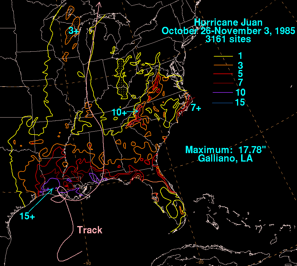 Because the hurricane looped twice near the coastline, Hurricane Juan brought extensive rainfall along the northern Gulf Coast, particularly across Louisiana and Texas. Deweyville, Texas
received a maximum of 8.7 inches (220 mm) and Mobile, Alabama
reached a total of 11.9 inches (302 mm), while Louisiana
reported over to 10 inches (254 mm), with a storm maximum of 17.78 inches (452 mm) of rain in Galliano
according to information compiled from the National Climatic Data Center in Asheville, North Carolina. Storm surge was moderate, peaking at 8.2 feet (2.5 m) on the southern portion of Louisiana, though tides returned to below normal levels when offshore winds forced the surge out to sea. A few small tornadoes were reported along Juan's outer edges, though little damage was reported.
Severe coastal flooding resulted in significant crop damage and loss of livestock in southern Louisiana. Thousands of houses were flooded and destroyed, mainly around Lake Pontchartrain
, though property damage was seen from Texas through the Florida Panhandle, albeit much less than Louisiana. 2 people drowned from the flood waters in Louisiana, and 1 person died in a boating accident of the Texas coast. There were 1,357 injuries reported by FEMA, though most were minor. Total damage from Hurricane Juan amounted to $1.5 billion (1985 USD), making it one of the costliest hurricanes at the time and making it the costliest non-retired hurricane name.
, Virginia
, Maryland
, and Pennsylvania
.
Flooding in West Virginia was the worst in the state's history. The worst hit areas were the Cheat River
and South Branch Potomac River
basins. The remnants of Juan caused 38 fatalities and $578 million from the flooding.
Flash flooding on November 4 and 5 resulted in overflown rivers across much of Virginia, including the Roanoke River
which rose 23 feet above its banks. The flooding resulted in 12 casualties in Virginia, with $800 million in damage (1985 USD).
Louisiana
Louisiana is a state located in the southern region of the United States of America. Its capital is Baton Rouge and largest city is New Orleans. Louisiana is the only state in the U.S. with political subdivisions termed parishes, which are local governments equivalent to counties...
coast, causing torrential flooding for several days. Juan was the costliest hurricane of the 1985 Atlantic hurricane season
1985 Atlantic hurricane season
The 1985 Atlantic hurricane season had the most U.S. landfalling tropical cyclones since 1916. The season officially began on June 1, 1985, and lasted until November 30, 1985...
, and at the time was among the costliest of all historical U.S. hurricanes. Juan was the last of three hurricanes to affect Louisiana during the season, including Danny in August and Elena
Hurricane Elena
Hurricane Elena was a category 3 major hurricane that produced heavy damage along the Gulf Coast of the United States in August and September of the 1985 Atlantic hurricane season. The fifth tropical storm, fourth hurricane, and first major hurricane of the season, Elena developed near Cuba from a...
in early September.
Meteorological history
An upper level low pressure system combined with a tropical wave developed a broad trough of low pressure over the central Gulf of MexicoGulf of Mexico
The Gulf of Mexico is a partially landlocked ocean basin largely surrounded by the North American continent and the island of Cuba. It is bounded on the northeast, north and northwest by the Gulf Coast of the United States, on the southwest and south by Mexico, and on the southeast by Cuba. In...
on October 24. A rapid increase in cloudiness and convection led to the formation of a tropical depression on October 26. A high pressure system to its northeast forced it westward, where it became Tropical Storm Juan later on October 26.
At the time and throughout its lifetime, Juan was very disorganized, and resembled a subtropical cyclone
Subtropical cyclone
A subtropical cyclone is a weather system that has some characteristics of a tropical and an extratropical cyclone. As early as the 1950s, meteorologists were unclear whether they should be characterized as tropical or extratropical cyclones. They were officially recognized by the National...
with its winds well away from the center. A developing trough brought the storm northward, where it became better organized. Early on October 28, Juan reached hurricane strength, and hours later it reached a peak of 85 mph (140 km/h) winds.
Under the influence of a large scale upper-level low pressure area, Juan executed a cyclonic loop off the Louisiana
Louisiana
Louisiana is a state located in the southern region of the United States of America. Its capital is Baton Rouge and largest city is New Orleans. Louisiana is the only state in the U.S. with political subdivisions termed parishes, which are local governments equivalent to counties...
coast later on October 28. It turned northward, and hit near Morgan City, Louisiana
Morgan City, Louisiana
Morgan City is a city in St. Martin and St. Mary parishes in the U.S. state of Louisiana. The population was 12,404 at the 2010 census....
on the morning of October 29. Still under the influence of the low, Juan again looped to the southeast, and weakened to a tropical storm over land on October 29, and emerged into the Gulf of Mexico on October 30 over Vermilion Bay
Vermilion Bay
Vermilion Bay is a bay in southern Louisiana in the United States.Vermilion Bay is located in southwestern Iberia Parish and southeastern Vermilion Parish...
.
Juan paralleled the southern Louisiana coastline and crossed the extreme southeast portion of the state on October 31. Over the open waters of the Gulf, Juan restrengthened to a 70 mph (110 km/h) storm, just before hitting near the Alabama
Alabama
Alabama is a state located in the southeastern region of the United States. It is bordered by Tennessee to the north, Georgia to the east, Florida and the Gulf of Mexico to the south, and Mississippi to the west. Alabama ranks 30th in total land area and ranks second in the size of its inland...
/Florida
Florida
Florida is a state in the southeastern United States, located on the nation's Atlantic and Gulf coasts. It is bordered to the west by the Gulf of Mexico, to the north by Alabama and Georgia and to the east by the Atlantic Ocean. With a population of 18,801,310 as measured by the 2010 census, it...
border that night. Once over land, Juan rapidly weakened, and became extratropical over Tennessee
Tennessee
Tennessee is a U.S. state located in the Southeastern United States. It has a population of 6,346,105, making it the nation's 17th-largest state by population, and covers , making it the 36th-largest by total land area...
on November 1. Its remnants accelerated northward into Canada by the morning of November 3. Of interest, an upper level low closed off in the wake of Juan, forming a new occluded cyclone, which added to the rainfall totals across Virginia and West Virginia. The combined impact of Juan and the occluded cyclone that formed in its wake led to a flood of record size across West Virginia.
Impact
Gulf of Mexico
Early in its lifetime, Juan caused 25 to 35 foot (7.5 to 10.5 meter) swells, damaging several offshore oil platforms and overturning two. High winds prior to the storm's development encumbered evacuation efforts. Because of this, nine people died, either from toppled oil rigs or from drowning while being transported from the rigs. The oil industry suffered greatly from the hurricane, both due to the lack of production and from lost oil rigs.Northern Gulf Coast
Deweyville, Texas
Deweyville is a census-designated place in Newton County, Texas, United States. The population was 1,190 at the 2000 census.-Geography:Deweyville is located at ....
received a maximum of 8.7 inches (220 mm) and Mobile, Alabama
Mobile, Alabama
Mobile is the third most populous city in the Southern US state of Alabama and is the county seat of Mobile County. It is located on the Mobile River and the central Gulf Coast of the United States. The population within the city limits was 195,111 during the 2010 census. It is the largest...
reached a total of 11.9 inches (302 mm), while Louisiana
Louisiana
Louisiana is a state located in the southern region of the United States of America. Its capital is Baton Rouge and largest city is New Orleans. Louisiana is the only state in the U.S. with political subdivisions termed parishes, which are local governments equivalent to counties...
reported over to 10 inches (254 mm), with a storm maximum of 17.78 inches (452 mm) of rain in Galliano
Galliano, Louisiana
Galliano is a census-designated place on the Bayou Lafourche in Lafourche Parish, Louisiana, in the United States. As of the 2000 census, the CDP population was 7,356...
according to information compiled from the National Climatic Data Center in Asheville, North Carolina. Storm surge was moderate, peaking at 8.2 feet (2.5 m) on the southern portion of Louisiana, though tides returned to below normal levels when offshore winds forced the surge out to sea. A few small tornadoes were reported along Juan's outer edges, though little damage was reported.
Severe coastal flooding resulted in significant crop damage and loss of livestock in southern Louisiana. Thousands of houses were flooded and destroyed, mainly around Lake Pontchartrain
Lake Pontchartrain
Lake Pontchartrain is a brackish estuary located in southeastern Louisiana. It is the second-largest inland saltwater body of water in the United States, after the Great Salt Lake in Utah, and the largest lake in Louisiana. As an estuary, Pontchartrain is not a true lake.It covers an area of with...
, though property damage was seen from Texas through the Florida Panhandle, albeit much less than Louisiana. 2 people drowned from the flood waters in Louisiana, and 1 person died in a boating accident of the Texas coast. There were 1,357 injuries reported by FEMA, though most were minor. Total damage from Hurricane Juan amounted to $1.5 billion (1985 USD), making it one of the costliest hurricanes at the time and making it the costliest non-retired hurricane name.
Appalachian Mountains
Though not directly related to the hurricane, Juan's tropical moisture combined with another low pressure system to drop large amounts of moisture across the Appalachian Mountains and the Mid-Atlantic. Many locations reported record amounts of rainfall from West VirginiaWest Virginia
West Virginia is a state in the Appalachian and Southeastern regions of the United States, bordered by Virginia to the southeast, Kentucky to the southwest, Ohio to the northwest, Pennsylvania to the northeast and Maryland to the east...
, Virginia
Virginia
The Commonwealth of Virginia , is a U.S. state on the Atlantic Coast of the Southern United States. Virginia is nicknamed the "Old Dominion" and sometimes the "Mother of Presidents" after the eight U.S. presidents born there...
, Maryland
Maryland
Maryland is a U.S. state located in the Mid Atlantic region of the United States, bordering Virginia, West Virginia, and the District of Columbia to its south and west; Pennsylvania to its north; and Delaware to its east...
, and Pennsylvania
Pennsylvania
The Commonwealth of Pennsylvania is a U.S. state that is located in the Northeastern and Mid-Atlantic regions of the United States. The state borders Delaware and Maryland to the south, West Virginia to the southwest, Ohio to the west, New York and Ontario, Canada, to the north, and New Jersey to...
.
Flooding in West Virginia was the worst in the state's history. The worst hit areas were the Cheat River
Cheat River
The Cheat River is a tributary of the Monongahela River in eastern West Virginia and southwestern Pennsylvania in the United States. Via the Monongahela and Ohio rivers, it is part of the Mississippi River watershed, ultimately draining into the Gulf of Mexico.-Geography:The Cheat is formed at...
and South Branch Potomac River
Potomac River
The Potomac River flows into the Chesapeake Bay, located along the mid-Atlantic coast of the United States. The river is approximately long, with a drainage area of about 14,700 square miles...
basins. The remnants of Juan caused 38 fatalities and $578 million from the flooding.
Flash flooding on November 4 and 5 resulted in overflown rivers across much of Virginia, including the Roanoke River
Roanoke River
The Roanoke River is a river in southern Virginia and northeastern North Carolina in the United States, 410 mi long. A major river of the southeastern United States, it drains a largely rural area of the coastal plain from the eastern edge of the Appalachian Mountains southeast across the Piedmont...
which rose 23 feet above its banks. The flooding resulted in 12 casualties in Virginia, with $800 million in damage (1985 USD).
See also
- Other storms of the same name
- List of North Carolina hurricanes (1980–present)
External links
- [ftp://ftp.nhc.noaa.gov/pub/storm_archives/atlantic/prelimat/atl1985/juan/ NHC Juan Report]
- HPC Juan Rainfall Page
- Monetary Information
- Coastal and Inland Information