
1944 Great Atlantic Hurricane
Encyclopedia
The Great Atlantic Hurricane in 1944 was an intense Atlantic hurricane sometimes compared to the New England Hurricane of 1938
.
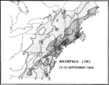
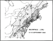
. It likely developed from a tropical wave several days before. It moved west-northwestward, and steadily intensified to a 140 mi/h major hurricane on the 12th, northeast of the Bahamas. Around this time, the Miami Hurricane Warning Office designated this storm "The Great Atlantic Hurricane" to emphasize its intensity and size, which appears to be the first time a name was designated by the office which evolved into the National Hurricane Center
. The hurricane turned northward and hit the Outer Banks
later that day.
Moving rapidly to the northeast, the hurricane maintained its strength first giving a strong and destructive glancing blow to the Jersey Shore
before making landfall on Long Island
on September 15, hitting as a Category 3 hurricane. Shortly thereafter it crossed the Rhode Island
coastline, and after emerging into the Massachusetts Bay it hit Maine
, just before becoming extratropical. The non-tropical system continued northeastward, and merged with a larger extratropical low on the 16th, south of Greenland
.
 The hurricane caused $100 million in damage ($965 million in 2010 USD
), roughly one-third of the 1938 hurricane. 390 lives were lost during the hurricane; most from marine casualties. 46 deaths occurred on land, the low toll due to well-executed warnings and evacuations.
The last time two intense New England hurricanes occurred so closely together were the Great September Gale of 1815
and the 1821 Norfolk and Long Island Hurricane.
, North Carolina
causing the residents to relocate the entire village of Kinnakeet a few miles further south. Just off Oregon Inlet
, it sank two United States Coast Guard Cutter
s, USCGC Jackson (WSC-142) and USCGC Bedloe (WSC-128), with a loss of 48 men.
, and Cape May
all suffered major damage. Long Beach Island and Barnegat Island both lost their causeways to the mainland in the storm effectively cutting them off from the rest of New Jersey. Additionally both islands lost hundreds of homes, in particular the Harvey Cedars
section of Long Beach Island where many homes in the town were swept out to sea. In Atlantic City the hurricane's storm surge forced water into the lobbies of many of the resorts famous hotels. The Atlantic City boardwalk suffered major damage along with the citys famous ocean piers. Both the famed Steel Pier
and Heinz Pier were partially destroyed by the hurricane with only the Steel Pier getting rebuilt. Ocean City and Cape May also lost many homes in the storm with Ocean City's boardwalk suffering significant damage. Larry Savadove devotes a whole chapter in his book Great Storms of the Jersey Shore to the hurricane and the imprint and lore it left on the Jersey Shore.
approximately 450 miles (724.2 km) east of Vero Beach, FL, with a loss of 248 sailors. The hurricane was one of the most powerful to traverse the Eastern Seaboard, reaching Category 4 when it encountered the Warrington, and producing hurricane force winds over a diameter of 600 miles (965.6 km). The hurricane also produced waves in excess of 70 feet (21.3 m) in height. The hurricane and the sinking of the USS Warrington are documented in the 1996 book The Dragon's Breath - Hurricane At Sea, written by Commander Robert A. Dawes, Jr. (a former Commanding Officer of the Warrington), and published by Naval Institute Press.
In addition to the Warrington and the Coast Guard Cutters Bedloe and Jackson, this hurricane claimed the 136 feet (41.5 m) long minesweeper USS YMS-409 which foundered and sank with all 33 on board lost. Further north, it also claimed the Lightship Vineyard Sound (LV-73), which was sunk with the loss of all 12 aboard. It also drove the S.S. Thomas Tracy aground in Rehoboth Beach, Delaware.
New England Hurricane of 1938
The New England Hurricane of 1938 was the first major hurricane to strike New England since 1869...
.
Meteorological history
A hurricane was first detected on September 9, northeast of the Lesser AntillesLesser Antilles
The Lesser Antilles are a long, partly volcanic island arc in the Western Hemisphere. Most of its islands form the eastern boundary of the Caribbean Sea with the Atlantic Ocean, with the remainder located in the southern Caribbean just north of South America...
. It likely developed from a tropical wave several days before. It moved west-northwestward, and steadily intensified to a 140 mi/h major hurricane on the 12th, northeast of the Bahamas. Around this time, the Miami Hurricane Warning Office designated this storm "The Great Atlantic Hurricane" to emphasize its intensity and size, which appears to be the first time a name was designated by the office which evolved into the National Hurricane Center
National Hurricane Center
The National Hurricane Center , located at Florida International University in Miami, Florida, is the division of the National Weather Service responsible for tracking and predicting weather systems within the tropics between the Prime Meridian and the 140th meridian west poleward to the 30th...
. The hurricane turned northward and hit the Outer Banks
Outer Banks
The Outer Banks is a 200-mile long string of narrow barrier islands off the coast of North Carolina, beginning in the southeastern corner of Virginia Beach on the east coast of the United States....
later that day.
Moving rapidly to the northeast, the hurricane maintained its strength first giving a strong and destructive glancing blow to the Jersey Shore
Jersey Shore
The Jersey Shore is a term used to refer to both the Atlantic coast of the U.S. state of New Jersey and the adjacent resort and residential communities. . The New Jersey State Department of Tourism considers the Shore Region, Greater Atlantic City, and the Southern Shore to be distinct, each having...
before making landfall on Long Island
Long Island
Long Island is an island located in the southeast part of the U.S. state of New York, just east of Manhattan. Stretching northeast into the Atlantic Ocean, Long Island contains four counties, two of which are boroughs of New York City , and two of which are mainly suburban...
on September 15, hitting as a Category 3 hurricane. Shortly thereafter it crossed the Rhode Island
Rhode Island
The state of Rhode Island and Providence Plantations, more commonly referred to as Rhode Island , is a state in the New England region of the United States. It is the smallest U.S. state by area...
coastline, and after emerging into the Massachusetts Bay it hit Maine
Maine
Maine is a state in the New England region of the northeastern United States, bordered by the Atlantic Ocean to the east and south, New Hampshire to the west, and the Canadian provinces of Quebec to the northwest and New Brunswick to the northeast. Maine is both the northernmost and easternmost...
, just before becoming extratropical. The non-tropical system continued northeastward, and merged with a larger extratropical low on the 16th, south of Greenland
Greenland
Greenland is an autonomous country within the Kingdom of Denmark, located between the Arctic and Atlantic Oceans, east of the Canadian Arctic Archipelago. Though physiographically a part of the continent of North America, Greenland has been politically and culturally associated with Europe for...
.
Impact
United States dollar
The United States dollar , also referred to as the American dollar, is the official currency of the United States of America. It is divided into 100 smaller units called cents or pennies....
), roughly one-third of the 1938 hurricane. 390 lives were lost during the hurricane; most from marine casualties. 46 deaths occurred on land, the low toll due to well-executed warnings and evacuations.
The last time two intense New England hurricanes occurred so closely together were the Great September Gale of 1815
Great September Gale of 1815
The Great September Gale of 1815 is one of five "major hurricanes" to strike New England since 1635...
and the 1821 Norfolk and Long Island Hurricane.
Hatteras
This storm wreaked havoc on Hatteras IslandHatteras Island
Hatteras Island is a barrier island located off the North Carolina coast. Dividing the Atlantic Ocean and the Pamlico Sound, it runs parallel to the coast, forming a bend at Cape Hatteras. It is part of North Carolina's Outer Banks and includes the towns of Rodanthe, Waves, Salvo, Avon, Buxton,...
, North Carolina
North Carolina
North Carolina is a state located in the southeastern United States. The state borders South Carolina and Georgia to the south, Tennessee to the west and Virginia to the north. North Carolina contains 100 counties. Its capital is Raleigh, and its largest city is Charlotte...
causing the residents to relocate the entire village of Kinnakeet a few miles further south. Just off Oregon Inlet
Oregon Inlet
Oregon Inlet is an inlet along North Carolina's Outer Banks. It joins the Pamlico Sound with the Atlantic Ocean and separates Bodie Island from Pea Island, which are connected by a 2.5 mile bridge that spans the inlet...
, it sank two United States Coast Guard Cutter
United States Coast Guard Cutter
Cutter is the term used by the United States Coast Guard for its commissioned vessels. A Cutter is or greater in length, has a permanently assigned crew, and has accommodations for the crew to live aboard...
s, USCGC Jackson (WSC-142) and USCGC Bedloe (WSC-128), with a loss of 48 men.
Jersey Shore
The hurricane was infamous for the amount of damage it caused along the New Jersey coastline. The shore towns on Long Beach Island, as well as Barnegat, Atlantic City, Ocean CityOcean City, New Jersey
Ocean City is a city in Cape May County, New Jersey, United States. It is the principal city of the Ocean City Metropolitan Statistical Area which encompasses all of Cape May County. As of the 2010 United States Census, the city population was 11,701...
, and Cape May
Cape May, New Jersey
Cape May is a city at the southern tip of Cape May Peninsula in Cape May County, New Jersey, where the Delaware Bay meets the Atlantic Ocean and is one of the country's oldest vacation resort destinations. It is part of the Ocean City Metropolitan Statistical Area. As of the 2010 United States...
all suffered major damage. Long Beach Island and Barnegat Island both lost their causeways to the mainland in the storm effectively cutting them off from the rest of New Jersey. Additionally both islands lost hundreds of homes, in particular the Harvey Cedars
Harvey Cedars, New Jersey
Harvey Cedars is a Borough in Ocean County, New Jersey, United States. As of the 2010 Census, the borough population was 337. The borough borders the Atlantic Ocean on Long Beach Island....
section of Long Beach Island where many homes in the town were swept out to sea. In Atlantic City the hurricane's storm surge forced water into the lobbies of many of the resorts famous hotels. The Atlantic City boardwalk suffered major damage along with the citys famous ocean piers. Both the famed Steel Pier
Steel Pier
Steel Pier is a amusement pier in Atlantic City, New Jersey, located opposite The Boardwalk from Trump Taj Mahal.The pier was owned by Trump Entertainment Resorts until 2011, when it was sold to the Catanoso Family under the "Steel Pier Associates, LLC" name. The Catanosos previously leased the...
and Heinz Pier were partially destroyed by the hurricane with only the Steel Pier getting rebuilt. Ocean City and Cape May also lost many homes in the storm with Ocean City's boardwalk suffering significant damage. Larry Savadove devotes a whole chapter in his book Great Storms of the Jersey Shore to the hurricane and the imprint and lore it left on the Jersey Shore.
USS Warrington
The storm was also responsible for sinking the Navy destroyer USS Warrington (DD-383)USS Warrington (DD-383)
USS Warrington — a — was the second ship of the United States Navy to be named for Lewis Warrington, who was an officer in the Navy during the Barbary Wars and the War of 1812...
approximately 450 miles (724.2 km) east of Vero Beach, FL, with a loss of 248 sailors. The hurricane was one of the most powerful to traverse the Eastern Seaboard, reaching Category 4 when it encountered the Warrington, and producing hurricane force winds over a diameter of 600 miles (965.6 km). The hurricane also produced waves in excess of 70 feet (21.3 m) in height. The hurricane and the sinking of the USS Warrington are documented in the 1996 book The Dragon's Breath - Hurricane At Sea, written by Commander Robert A. Dawes, Jr. (a former Commanding Officer of the Warrington), and published by Naval Institute Press.
In addition to the Warrington and the Coast Guard Cutters Bedloe and Jackson, this hurricane claimed the 136 feet (41.5 m) long minesweeper USS YMS-409 which foundered and sank with all 33 on board lost. Further north, it also claimed the Lightship Vineyard Sound (LV-73), which was sunk with the loss of all 12 aboard. It also drove the S.S. Thomas Tracy aground in Rehoboth Beach, Delaware.
See also
- List of tropical cyclones
- List of Atlantic hurricanes
- List of Delaware hurricanes
- List of North Carolina hurricanes