
Hurricane Jeanne
Encyclopedia
Hurricane Jeanne was the deadliest hurricane in the 2004 Atlantic hurricane season
. It was the tenth named storm
, the seventh hurricane
, and the fifth major hurricane of the season, as well as the third hurricane and fourth named storm of the season to make landfall in Florida. After wreaking havoc on Hispaniola, Jeanne struggled to reorganize, eventually strengthening and performing a complete loop over the open Atlantic. It headed westwards, strengthening into a Category 2 hurricane and passing over the islands of Great Abaco and Grand Bahama
in the Bahamas on September 25. Jeanne made landfall later in the day in Florida just 2 miles (3 kilometers) from where Frances had struck 3 weeks earlier. Building on the rainfall of Frances
and Ivan
, Jeanne brought near-record flood levels as far north as West Virginia
and New Jersey
before its remnants turned east into the open Atlantic. Jeanne is blamed for at least 3,006 deaths in Haiti
with about 2,800 in Gonaïves
alone, which was nearly washed away by floods and mudslides. The storm also caused 7 deaths in Puerto Rico
, 18 in the Dominican Republic
and at least 4 in Florida
, bringing the total number of deaths to at least 3,025; Jeanne is the 12th most deadly storm in the Atlantic hurricane history ever. Final property damage in the United States was $6.8 billion, making this the 13th costliest hurricane in U.S. history.
in the evening of September 13, and was upgraded to Tropical Storm Jeanne the next day. Jeanne passed south of the U.S. Virgin Islands on September 15, making landfall
near Yabucoa, Puerto Rico
later the same day. After crossing Puerto Rico
, Jeanne reached hurricane strength on September 16 near the eastern tip of the Dominican Republic
on the island of Hispaniola
, but fell back to tropical storm strength later that day as it moved across the mountainous island. Jeanne moved offshore the Dominican Republic late in the afternoon of September 17. By that time, Jeanne had weakened to tropical depression strength. Even though Jeanne did not strike Haiti directly, the storm was large enough to cause flooding and mudslides, particularly in the northwestern part of the country.
 On September 18, while the system was being tracked near Great Inagua and Haiti
, a new center formed well to the northeast and the previous circulation dissipated. The system restrengthened, becoming a hurricane on September 20. Jeanne continued to meander for several days (making a complete loop in the process) before beginning a steady westward motion toward the Bahamas and Florida
.
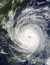
Jeanne continued strengthening as it headed west, passing over Great Abaco in the Bahamas on the morning of September 25. Shortly thereafter, the hurricane reached Category 3
strength. Jeanne maintained this intensity as it passed Grand Bahama
Island. At 11:50 p.m. EDT on September 25 (0350 UTC September 26), Jeanne made landfall on Hutchinson Island
, just east of Sewall's Point, Florida
, Stuart, Florida
and Port Saint Lucie, Florida, at Category 3 strength. This is the same place Hurricane Frances
struck Florida three weeks earlier. Jeanne was the first major (Category 3 or higher) storm to make landfall on the East coast between Palm Beach, Florida
and the mouth of the Savannah River
since 1899.
Jeanne's track continued to follow within 20 miles (32.2 km) of that of Frances until it reached Pasco County
. The cyclone
then swung more rapidly to the north, and the center remained over land all the way to the Georgia
state line, unlike Frances which exited into the Gulf of Mexico
. Jeanne became an extratropical cyclone
over Virginia
on September 28 and the system moved back into the Atlantic offshore the New Jersey
coast the next day.
as the storm approached to prevent electrocutions and infrastructure damage.
 Tropical storm watches were issued from Cabrera to Isla Saona early in the afternoon on September 14. Later that afternoon, hurricane watches and tropical storm warnings were raised from Cabrera to Santo Domingo. Late in the morning of September 15, hurricane warnings were issued from Cabrera to Isla Saona, while hurricane watches and tropical storm warnings were raised from Cabrera to Puerto Plata. That evening, hurricane warnings were extended westward from Cabrera to Puerto Plata while hurricane watches and tropical storm warnings were issued from Puerto Plata to Monte Cristo. Late in the morning of September 16, tropical storm warnings were issued from Le Mole St. Nicholas to Puerto Plata. That afternoon, hurricane warnings were downgraded to tropical storm warnings from Puerto Plata to Isla Saona while all hurricane watches were dropped. Late on the afternoon of September 17, tropical storm warnings were dropped for the remainder of Hispanola. After the 2004 Haiti rebellion that exiled Jean-Bertrand Aristide
from power, the elected government were replaced with a new regime which did not protect the basic survival needs of the Haitian population, which leads to particularly bad consequences of Hurricane Jeanne.
were rushed and sudden, as it did not become apparent that the storm would make a direct hit until the morning of the 23rd. Indeed, it had appeared the storm would pass safely offshore just the night before. Voluntary evacuations were advised on Thursday Friday, plans for opening shelters on Saturday were distributed to the public, and Florida Power and Light warned that power could be out "for an extended period of time". Canals were also drained on the same day.
On Friday, the Palm Beach Zoo prepared for the storm by moving small animals and birds into buildings such as restrooms and restaurants. Evacuations began in earnest, with many residents leaving for the Keys, noting that the islands were the only location definitely out of harm's way. For once, evacuation to the Keys
made sense.
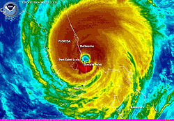
The center of Jeanne's eye achieved landfall near Stuart, at virtually the identical spot that Frances had come ashore three weeks earlier, the first time in record keeping that a hurricane made landfall in the same place as a previous storm of the same season. Maximum winds at the time of landfall were estimated to be near 120 m.p.h.
midday on September 15. The storm generally moved northwest through the island, exiting on the northwest coast near the town of Mayagüez around 11 p.m. Jeanne passed directly over the towns of Arroyo
, Patillas
, Guayama
and Salinas
on its trip over the Commonwealth. San Juan reported a wind gust of 73 mi/h, Carolina reported gusts to 71 mi/h, and rainfall ranged from 5.98 inches (151.9 mm) in the city to over 24 inches (609.6 mm) in Vieques. This excessive rainfall resulted in damage to roads, landslides, and collapsed bridges. This resulted in one death and the evacuation of 400 people near the Río Grande de Añasco. A total of eight people were reported dead in Puerto Rico as a result of Jeanne. Damages from the storm were estimated at $169.5 million (2004 USD).
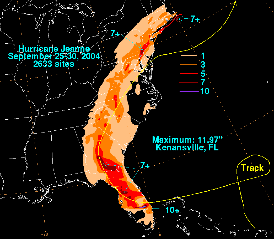
 By September 17, heavy rains totaling about 13 inches (330 mm) in the northern mountains of Haiti
caused severe flooding and mudslides in the Artibonite
region of the country, causing particular damage in the coastal city of Gonaïves
, where it affected about 80,000 of the city's 100,000 residents. As of October 6, 2004 the official report counted 3,006 people dead, with 2,826 of those in Gonaïves alone. Another 2,601 people were injured,and 7 people died
In the Dominican Republic
, the storm dumped torrential flooding rains and killing over two dozen. Damage totaled $270 million (2004 USD).
 Millions in Florida were left without electricity, some for the third time in a month. There were only five direct deaths in the mainland United States, three in Florida
, one in South Carolina
and one in Virginia
. The final US damage was determined to be around $6.9 billion, making it the 15th costliest hurricane in United States history. It was difficult to isolate this from damage caused by Hurricane Frances
(and, around Polk County
, and Highlands County
, and from Hurricane Charley
as well). While Jeanne was highly destructive, It almost killed a small child and his mom while evacuating a 4 star hotel in Port St.Lucie. They were rescued sometime after that.
As the storm moved northward east of the Appalachian Mountains
, it continued producing heavy rains and flash flooding. Rainfall exceeded 6.00 inches (150 mm) as far north as New Jersey
and Pennsylvania
, resulting in severe flash flooding in Philadelphia, Pennsylvania
and its Pennsylvania
and New Jersey
suburbs on September 28. Tornadoes also touched down in Wilmington, Delaware
and Cherry Hill, New Jersey
.
. This led to widespread street flooding and several rivers overflowed their banks. Forty people had to be rescued from a bus along the White Clay Creek after the creek crested at 0.59 ft (0.179832 m) above flood-stage. A strong F2
tornado touched down in the state, injuring five people and leaving $1 million in damages. The tornado touched down in northern New Castle County
and tracked for 5 mi (8 km) and generated winds up to 130 mph (209.2 km/h). The county airport sustained significant damage, five C-130 cargo planes were damaged, thousands of pounds of jet fuel spilled, and damaged hangars. At a nearby industrial park, metal siding was torn off buildings, windows were shattered and power lines were downed. A self-storage facility sustained substantial damage.
In Maryland, Jeanne produced up to 4 in (101.6 mm) of rain, triggering flash flooding throughout the state. Numerous roads were flooded, including parts of Maryland Route 17
. Several rivers rose above their flood-stage, with the Big Elk Creek cresting at 9.3 ft (2.8 m), 0.3 ft (0.09144 m) above food-stage. A total of 50 roads were closed due to high water throughout the state. Numerous reports of stranded vehicles were sent to the Emergency Operations Center. In Carroll County
, a group of inmates required rescue after the jail they were in flooded. One brief F0 tornado touched down in the state near Solomons
, causing minor damage.
, and will never again be used for an Atlantic hurricane. It was replaced with Julia for the 2010 Atlantic hurricane season
. Since the name Julia was not retired in 2010, it will also be used in the 2016 Atlantic hurricane season.
2004 Atlantic hurricane season
The 2004 Atlantic hurricane season officially began on June 1, 2004, and lasted until November 30, 2004. These dates conventionally delimit the period of each year when most tropical cyclones form in the Atlantic basin...
. It was the tenth named storm
Tropical cyclone
A tropical cyclone is a storm system characterized by a large low-pressure center and numerous thunderstorms that produce strong winds and heavy rain. Tropical cyclones strengthen when water evaporated from the ocean is released as the saturated air rises, resulting in condensation of water vapor...
, the seventh hurricane
Tropical cyclone
A tropical cyclone is a storm system characterized by a large low-pressure center and numerous thunderstorms that produce strong winds and heavy rain. Tropical cyclones strengthen when water evaporated from the ocean is released as the saturated air rises, resulting in condensation of water vapor...
, and the fifth major hurricane of the season, as well as the third hurricane and fourth named storm of the season to make landfall in Florida. After wreaking havoc on Hispaniola, Jeanne struggled to reorganize, eventually strengthening and performing a complete loop over the open Atlantic. It headed westwards, strengthening into a Category 2 hurricane and passing over the islands of Great Abaco and Grand Bahama
Grand Bahama
Grand Bahama is one of the northernmost of the islands of the Bahamas, and the closest major island to the United States, lying off the state of Florida. Grand Bahama is the fifth largest island in the Bahamas island chain of approximately 700 islands and 2,400 cays...
in the Bahamas on September 25. Jeanne made landfall later in the day in Florida just 2 miles (3 kilometers) from where Frances had struck 3 weeks earlier. Building on the rainfall of Frances
Hurricane Frances
Hurricane Frances was the sixth named storm, the fourth hurricane, and the third major hurricane of the 2004 Atlantic hurricane season. The system crossing the open Atlantic during mid to late August, moving to the north of the Lesser Antilles while strengthening. Its outer bands affected Puerto...
and Ivan
Hurricane Ivan
Hurricane Ivan was a large, long-lived, Cape Verde-type hurricane that caused widespread damage in the Caribbean and United States. The cyclone was the ninth named storm, the sixth hurricane and the fourth major hurricane of the active 2004 Atlantic hurricane season...
, Jeanne brought near-record flood levels as far north as West Virginia
West Virginia
West Virginia is a state in the Appalachian and Southeastern regions of the United States, bordered by Virginia to the southeast, Kentucky to the southwest, Ohio to the northwest, Pennsylvania to the northeast and Maryland to the east...
and New Jersey
New Jersey
New Jersey is a state in the Northeastern and Middle Atlantic regions of the United States. , its population was 8,791,894. It is bordered on the north and east by the state of New York, on the southeast and south by the Atlantic Ocean, on the west by Pennsylvania and on the southwest by Delaware...
before its remnants turned east into the open Atlantic. Jeanne is blamed for at least 3,006 deaths in Haiti
Haiti
Haiti , officially the Republic of Haiti , is a Caribbean country. It occupies the western, smaller portion of the island of Hispaniola, in the Greater Antillean archipelago, which it shares with the Dominican Republic. Ayiti was the indigenous Taíno or Amerindian name for the island...
with about 2,800 in Gonaïves
Gonaïves
Gonaïves is a city in northern Haiti, the capital of the Artibonite Department. It has a population of about 104,825 people . The city's name derives from the original Amerindian name of Gonaibo. It is also known as Haïti's "independence city"...
alone, which was nearly washed away by floods and mudslides. The storm also caused 7 deaths in Puerto Rico
Puerto Rico
Puerto Rico , officially the Commonwealth of Puerto Rico , is an unincorporated territory of the United States, located in the northeastern Caribbean, east of the Dominican Republic and west of both the United States Virgin Islands and the British Virgin Islands.Puerto Rico comprises an...
, 18 in the Dominican Republic
Dominican Republic
The Dominican Republic is a nation on the island of La Hispaniola, part of the Greater Antilles archipelago in the Caribbean region. The western third of the island is occupied by the nation of Haiti, making Hispaniola one of two Caribbean islands that are shared by two countries...
and at least 4 in Florida
Florida
Florida is a state in the southeastern United States, located on the nation's Atlantic and Gulf coasts. It is bordered to the west by the Gulf of Mexico, to the north by Alabama and Georgia and to the east by the Atlantic Ocean. With a population of 18,801,310 as measured by the 2010 census, it...
, bringing the total number of deaths to at least 3,025; Jeanne is the 12th most deadly storm in the Atlantic hurricane history ever. Final property damage in the United States was $6.8 billion, making this the 13th costliest hurricane in U.S. history.
Meteorological history
Tropical Depression Eleven formed from a tropical wave 70 miles (110 km) east-southeast of GuadeloupeGuadeloupe
Guadeloupe is an archipelago located in the Leeward Islands, in the Lesser Antilles, with a land area of 1,628 square kilometres and a population of 400,000. It is the first overseas region of France, consisting of a single overseas department. As with the other overseas departments, Guadeloupe...
in the evening of September 13, and was upgraded to Tropical Storm Jeanne the next day. Jeanne passed south of the U.S. Virgin Islands on September 15, making landfall
Landfall (meteorology)
Landfall is the event of a tropical cyclone or a waterspout coming onto land after being over water. When a waterspout makes landfall it is reclassified as a tornado, which can then cause damage inland...
near Yabucoa, Puerto Rico
Yabucoa, Puerto Rico
Yabucoa is a small town in the south eastern tip of Puerto Rico located in the southeastern region, north of Maunabo; south of San Lorenzo, Las Piedras and Humacao; and east of Patillas and about one hour from San Juan. Yabucoa is spread over 9 wards and Yabucoa Pueblo...
later the same day. After crossing Puerto Rico
Puerto Rico
Puerto Rico , officially the Commonwealth of Puerto Rico , is an unincorporated territory of the United States, located in the northeastern Caribbean, east of the Dominican Republic and west of both the United States Virgin Islands and the British Virgin Islands.Puerto Rico comprises an...
, Jeanne reached hurricane strength on September 16 near the eastern tip of the Dominican Republic
Dominican Republic
The Dominican Republic is a nation on the island of La Hispaniola, part of the Greater Antilles archipelago in the Caribbean region. The western third of the island is occupied by the nation of Haiti, making Hispaniola one of two Caribbean islands that are shared by two countries...
on the island of Hispaniola
Hispaniola
Hispaniola is a major island in the Caribbean, containing the two sovereign states of the Dominican Republic and Haiti. The island is located between the islands of Cuba to the west and Puerto Rico to the east, within the hurricane belt...
, but fell back to tropical storm strength later that day as it moved across the mountainous island. Jeanne moved offshore the Dominican Republic late in the afternoon of September 17. By that time, Jeanne had weakened to tropical depression strength. Even though Jeanne did not strike Haiti directly, the storm was large enough to cause flooding and mudslides, particularly in the northwestern part of the country.
Haiti
Haiti , officially the Republic of Haiti , is a Caribbean country. It occupies the western, smaller portion of the island of Hispaniola, in the Greater Antillean archipelago, which it shares with the Dominican Republic. Ayiti was the indigenous Taíno or Amerindian name for the island...
, a new center formed well to the northeast and the previous circulation dissipated. The system restrengthened, becoming a hurricane on September 20. Jeanne continued to meander for several days (making a complete loop in the process) before beginning a steady westward motion toward the Bahamas and Florida
Florida
Florida is a state in the southeastern United States, located on the nation's Atlantic and Gulf coasts. It is bordered to the west by the Gulf of Mexico, to the north by Alabama and Georgia and to the east by the Atlantic Ocean. With a population of 18,801,310 as measured by the 2010 census, it...
.
Jeanne continued strengthening as it headed west, passing over Great Abaco in the Bahamas on the morning of September 25. Shortly thereafter, the hurricane reached Category 3
Saffir-Simpson Hurricane Scale
The Saffir–Simpson Hurricane Scale , or the Saffir–Simpson Hurricane Wind Scale , classifies hurricanes — Western Hemisphere tropical cyclones that exceed the intensities of tropical depressions and tropical storms — into five categories distinguished by the intensities of their sustained winds...
strength. Jeanne maintained this intensity as it passed Grand Bahama
Grand Bahama
Grand Bahama is one of the northernmost of the islands of the Bahamas, and the closest major island to the United States, lying off the state of Florida. Grand Bahama is the fifth largest island in the Bahamas island chain of approximately 700 islands and 2,400 cays...
Island. At 11:50 p.m. EDT on September 25 (0350 UTC September 26), Jeanne made landfall on Hutchinson Island
Hutchinson Island
Hutchinson Island is a barrier island on the coast of Martin and St. Lucie counties, Florida. The southern one-third of Hutchinson Island is in Martin County while the northern two-thirds is in St. Lucie County. It is bounded on the east by the Atlantic Ocean, on the south by the St...
, just east of Sewall's Point, Florida
Sewall's Point, Florida
Sewall's Point is a town located on the peninsula of the same name in Martin County, Florida, United States. The population was 1,946 at the 2000 census. As of 2004, the population recorded by the U.S. Census Bureau is 2,053 . Both the town and the peninsula are named for Capt...
, Stuart, Florida
Stuart, Florida
Stuart is the only incorporated city of Martin County, Florida, on Florida's Treasure Coast. The population was 14,633 at the 2000 census. As of 2007, the population recorded by the U.S. Census Bureau is 15,964....
and Port Saint Lucie, Florida, at Category 3 strength. This is the same place Hurricane Frances
Hurricane Frances
Hurricane Frances was the sixth named storm, the fourth hurricane, and the third major hurricane of the 2004 Atlantic hurricane season. The system crossing the open Atlantic during mid to late August, moving to the north of the Lesser Antilles while strengthening. Its outer bands affected Puerto...
struck Florida three weeks earlier. Jeanne was the first major (Category 3 or higher) storm to make landfall on the East coast between Palm Beach, Florida
Palm Beach, Florida
The Town of Palm Beach is an incorporated town in Palm Beach County, Florida, United States. The Intracoastal Waterway separates it from the neighboring cities of West Palm Beach and Lake Worth...
and the mouth of the Savannah River
Savannah River
The Savannah River is a major river in the southeastern United States, forming most of the border between the states of South Carolina and Georgia. Two tributaries of the Savannah, the Tugaloo River and the Chattooga River, form the northernmost part of the border...
since 1899.
Jeanne's track continued to follow within 20 miles (32.2 km) of that of Frances until it reached Pasco County
Pasco County, Florida
Pasco County is a county located in the U.S. state of Florida. As of 2000, the population was 344,765. The July 1, 2007 census estimate according to the U.S. Census Bureau for the county is 462,715. Its county seat is Dade City, Florida which is in the northeast part of the county - somewhat...
. The cyclone
Cyclone
In meteorology, a cyclone is an area of closed, circular fluid motion rotating in the same direction as the Earth. This is usually characterized by inward spiraling winds that rotate anticlockwise in the Northern Hemisphere and clockwise in the Southern Hemisphere of the Earth. Most large-scale...
then swung more rapidly to the north, and the center remained over land all the way to the Georgia
Georgia (U.S. state)
Georgia is a state located in the southeastern United States. It was established in 1732, the last of the original Thirteen Colonies. The state is named after King George II of Great Britain. Georgia was the fourth state to ratify the United States Constitution, on January 2, 1788...
state line, unlike Frances which exited into the Gulf of Mexico
Gulf of Mexico
The Gulf of Mexico is a partially landlocked ocean basin largely surrounded by the North American continent and the island of Cuba. It is bounded on the northeast, north and northwest by the Gulf Coast of the United States, on the southwest and south by Mexico, and on the southeast by Cuba. In...
. Jeanne became an extratropical cyclone
Extratropical cyclone
Extratropical cyclones, sometimes called mid-latitude cyclones or wave cyclones, are a group of cyclones defined as synoptic scale low pressure weather systems that occur in the middle latitudes of the Earth having neither tropical nor polar characteristics, and are connected with fronts and...
over Virginia
Virginia
The Commonwealth of Virginia , is a U.S. state on the Atlantic Coast of the Southern United States. Virginia is nicknamed the "Old Dominion" and sometimes the "Mother of Presidents" after the eight U.S. presidents born there...
on September 28 and the system moved back into the Atlantic offshore the New Jersey
New Jersey
New Jersey is a state in the Northeastern and Middle Atlantic regions of the United States. , its population was 8,791,894. It is bordered on the north and east by the state of New York, on the southeast and south by the Atlantic Ocean, on the west by Pennsylvania and on the southwest by Delaware...
coast the next day.
Puerto Rico and the Leeward Islands
On the afternoon of September 13, tropical storm watches were issued for the British Virgin Islands, Saba, St. Eustatius, and St. Maarten while tropical storm warnings were raised for Puerto Rico and the U.S. Virgin Islands. The watches were upgraded to tropical storm warnings early on the morning of September 14. Later in the morning, tropical storm warnings were issued for St. Kitts and Nevis, while tropical storm watches were issued for Anguilla. During the afternoon, tropical storm warnings were lowered for Saba, St. Eustatius, and St. Maarten, while hurricane warnings were issued for Puerto Rico and the U.S. Virgin Islands. Late on the morning of September 15, a hurricane watch was issued for the British Virgin Islands. That afternoon, tropical storm warnings were dropped for St. Kitts and Nevis, while hurricane warnings were lowered to tropical storm warnings for the U.S. Virgin Islands. On the evening of September 15, tropical storm warnings were dropped Puerto Rico and the U.S. Virgin Islands, while hurricane warnings were downgraded to tropical storm warnings for Puerto Rico, and all watches and warnings were dropped for the British Virgin Islands. The entire power grid of Puerto Rico was shut down by the government of Sila Maria CalderónSila María Calderón
Sila María Calderón Serra is a Puerto Rican politician and businesswoman who served as the seventh Governor of the Commonwealth of Puerto Rico from 2001 to 2005. She is the first and, to date, only woman elected to that office...
as the storm approached to prevent electrocutions and infrastructure damage.
Dominican Republic and Haiti
Jean-Bertrand Aristide
Jean-Bertrand Aristide is a Haitian former Catholic priest and politician who served as Haiti's first democratically elected president. A proponent of liberation theology, Aristide was appointed to a parish in Port-au-Prince in 1982 after completing his studies...
from power, the elected government were replaced with a new regime which did not protect the basic survival needs of the Haitian population, which leads to particularly bad consequences of Hurricane Jeanne.
Florida
Preparations in Central FloridaCentral Florida
Central Florida is a regional designation for the area surrounding Orlando in east central Florida, United States. The area represents the third largest population concentration in Florida, after the South Florida and Tampa Bay regions, respectively....
were rushed and sudden, as it did not become apparent that the storm would make a direct hit until the morning of the 23rd. Indeed, it had appeared the storm would pass safely offshore just the night before. Voluntary evacuations were advised on Thursday Friday, plans for opening shelters on Saturday were distributed to the public, and Florida Power and Light warned that power could be out "for an extended period of time". Canals were also drained on the same day.
On Friday, the Palm Beach Zoo prepared for the storm by moving small animals and birds into buildings such as restrooms and restaurants. Evacuations began in earnest, with many residents leaving for the Keys, noting that the islands were the only location definitely out of harm's way. For once, evacuation to the Keys
Florida Keys
The Florida Keys are a coral archipelago in southeast United States. They begin at the southeastern tip of the Florida peninsula, about south of Miami, and extend in a gentle arc south-southwest and then westward to Key West, the westernmost of the inhabited islands, and on to the uninhabited Dry...
made sense.
The center of Jeanne's eye achieved landfall near Stuart, at virtually the identical spot that Frances had come ashore three weeks earlier, the first time in record keeping that a hurricane made landfall in the same place as a previous storm of the same season. Maximum winds at the time of landfall were estimated to be near 120 m.p.h.
Impact
| Deaths from Hurricane Jeanne | ||||||
| Country | Total | State | County | County total |
Direct deaths |
|
|---|---|---|---|---|---|---|
| Dominican Republic Dominican Republic The Dominican Republic is a nation on the island of La Hispaniola, part of the Greater Antilles archipelago in the Caribbean region. The western third of the island is occupied by the nation of Haiti, making Hispaniola one of two Caribbean islands that are shared by two countries... |
18 | 18 | ||||
| Haiti Haiti Haiti , officially the Republic of Haiti , is a Caribbean country. It occupies the western, smaller portion of the island of Hispaniola, in the Greater Antillean archipelago, which it shares with the Dominican Republic. Ayiti was the indigenous Taíno or Amerindian name for the island... |
3,006+ | 3,006+ | ||||
| Puerto Rico Puerto Rico Puerto Rico , officially the Commonwealth of Puerto Rico , is an unincorporated territory of the United States, located in the northeastern Caribbean, east of the Dominican Republic and west of both the United States Virgin Islands and the British Virgin Islands.Puerto Rico comprises an... |
8 | 4 | ||||
| USA | 5 | Florida Florida Florida is a state in the southeastern United States, located on the nation's Atlantic and Gulf coasts. It is bordered to the west by the Gulf of Mexico, to the north by Alabama and Georgia and to the east by the Atlantic Ocean. With a population of 18,801,310 as measured by the 2010 census, it... |
Brevard Brevard County, Florida Brevard County is a county located in the U.S. state of Florida, along the coast of the Atlantic Ocean. As of 2007 U.S. Census Bureau estimates, the population is 536,521, making it the 10th most populous county in the state. Influenced by the presence of the John F. Kennedy Space Center, Brevard... |
170 | 159 | |
| Clay Clay County, Florida Clay County is a county located in the U.S. state of Florida. As of 2010, the population was 190,895. Its county seat is Green Cove Springs, Florida. Clay County is part of the Greater Jacksonville Metropolitan area.- History :... |
10 | 30 | ||||
| Indian River Indian River County, Florida Indian River County is a county located in the Treasure Coast region in the U.S. state of Florida. As of 2000, the population was 112,947. The U.S. Census Bureau 2005 estimate for the county is 128,594... |
111 | 135 | ||||
| South Carolina South Carolina South Carolina is a state in the Deep South of the United States that borders Georgia to the south, North Carolina to the north, and the Atlantic Ocean to the east. Originally part of the Province of Carolina, the Province of South Carolina was one of the 13 colonies that declared independence... |
Fairfield | 1 | 1 | |||
| Virginia Virginia The Commonwealth of Virginia , is a U.S. state on the Atlantic Coast of the Southern United States. Virginia is nicknamed the "Old Dominion" and sometimes the "Mother of Presidents" after the eight U.S. presidents born there... |
Patrick Patrick County, Virginia Patrick County is a county located in the Commonwealth of Virginia. As of 2010, the population was 18,490. Its county seat is Stuart. It is located within both the rolling hills and valleys of the Piedmont Region of Virginia and mountainous Southwest Virginia.... |
1 | 1 | |||
| Totals | 3,036+ | 3,593+ | ||||
| Because of differing sources, totals may not match. | ||||||
Puerto Rico
Puerto Rico was impacted by tropical storm force winds and heavy rain, with flooding on a historic scale. The storm made landfall near MaunaboMaunabo, Puerto Rico
Maunabo is a municipality of Puerto Rico located in the southeastern coast, northeast of Patillas and south of Yabucoa. Maunabo is spread over 8 wards and Maunabo Pueblo . It is part of the San Juan-Caguas-Guaynabo Metropolitan Statistical Area.The Mayor of the town is Jorge L. Márquez Pérez...
midday on September 15. The storm generally moved northwest through the island, exiting on the northwest coast near the town of Mayagüez around 11 p.m. Jeanne passed directly over the towns of Arroyo
Arroyo, Puerto Rico
Arroyo is a municipality located along the southern coast of Puerto Rico and bordered by the Caribbean Sea, east of the municipality of Guayama and northwest of the municipality of Patillas. Arroyo is spread over 5 wards and Arroyo Pueblo...
, Patillas
Patillas, Puerto Rico
Patillas is a municipality of Puerto Rico located in the southeastern coast, south of San Lorenzo; west of Yabucoa and Maunabo; and east of Guayama and Arroyo. It is spread over 15 wards and Patillas Pueblo...
, Guayama
Guayama, Puerto Rico
Guayama is a municipality of Puerto Rico founded on January 29, 1736 and located on the Southern Coastal Valley region, bordering the Caribbean, south of Cayey; east of Salinas; and west of Patillas and Arroyo. Guayama is spread over 9 wards and Guayama Pueblo...
and Salinas
Salinas, Puerto Rico
Salinas is a small municipality in the southern part of Puerto Rico located in the southern coast of the island, south of Aibonito and Cayey; southeast of Coamo, east of Santa Isabel; and west of Guayama...
on its trip over the Commonwealth. San Juan reported a wind gust of 73 mi/h, Carolina reported gusts to 71 mi/h, and rainfall ranged from 5.98 inches (151.9 mm) in the city to over 24 inches (609.6 mm) in Vieques. This excessive rainfall resulted in damage to roads, landslides, and collapsed bridges. This resulted in one death and the evacuation of 400 people near the Río Grande de Añasco. A total of eight people were reported dead in Puerto Rico as a result of Jeanne. Damages from the storm were estimated at $169.5 million (2004 USD).
Hispaniola
Haiti
Haiti , officially the Republic of Haiti , is a Caribbean country. It occupies the western, smaller portion of the island of Hispaniola, in the Greater Antillean archipelago, which it shares with the Dominican Republic. Ayiti was the indigenous Taíno or Amerindian name for the island...
caused severe flooding and mudslides in the Artibonite
Artibonite Department
Artibonite is one of the ten departments of Haiti. With an area of 4,984 km² it is Haiti's largest department. Artibonite has a population of 1,168,800 . The region is the country's main rice-growing area. The main cities are Gonaïves and Saint-Marc...
region of the country, causing particular damage in the coastal city of Gonaïves
Gonaïves
Gonaïves is a city in northern Haiti, the capital of the Artibonite Department. It has a population of about 104,825 people . The city's name derives from the original Amerindian name of Gonaibo. It is also known as Haïti's "independence city"...
, where it affected about 80,000 of the city's 100,000 residents. As of October 6, 2004 the official report counted 3,006 people dead, with 2,826 of those in Gonaïves alone. Another 2,601 people were injured,and 7 people died
In the Dominican Republic
Dominican Republic
The Dominican Republic is a nation on the island of La Hispaniola, part of the Greater Antilles archipelago in the Caribbean region. The western third of the island is occupied by the nation of Haiti, making Hispaniola one of two Caribbean islands that are shared by two countries...
, the storm dumped torrential flooding rains and killing over two dozen. Damage totaled $270 million (2004 USD).
United States
Florida
Florida is a state in the southeastern United States, located on the nation's Atlantic and Gulf coasts. It is bordered to the west by the Gulf of Mexico, to the north by Alabama and Georgia and to the east by the Atlantic Ocean. With a population of 18,801,310 as measured by the 2010 census, it...
, one in South Carolina
South Carolina
South Carolina is a state in the Deep South of the United States that borders Georgia to the south, North Carolina to the north, and the Atlantic Ocean to the east. Originally part of the Province of Carolina, the Province of South Carolina was one of the 13 colonies that declared independence...
and one in Virginia
Virginia
The Commonwealth of Virginia , is a U.S. state on the Atlantic Coast of the Southern United States. Virginia is nicknamed the "Old Dominion" and sometimes the "Mother of Presidents" after the eight U.S. presidents born there...
. The final US damage was determined to be around $6.9 billion, making it the 15th costliest hurricane in United States history. It was difficult to isolate this from damage caused by Hurricane Frances
Hurricane Frances
Hurricane Frances was the sixth named storm, the fourth hurricane, and the third major hurricane of the 2004 Atlantic hurricane season. The system crossing the open Atlantic during mid to late August, moving to the north of the Lesser Antilles while strengthening. Its outer bands affected Puerto...
(and, around Polk County
Polk County, Florida
Polk County is located in central Florida between the Tampa Bay and Greater Orlando metropolitan areas. The county was established by the state government in 1861 on the eve of the American Civil War and named after former United States president James K. Polk. The county seat is Bartow and its...
, and Highlands County
Highlands County, Florida
Highlands County is a county located in the U.S. state of Florida. The U.S. Census Bureau 2006 estimate for the population was 97,346. Its county seat is Sebring, Florida. The county comprises the Sebring, Florida, Micropolitan Statistical Area.- History :...
, and from Hurricane Charley
Hurricane Charley
Hurricane Charley was the third named storm, the second hurricane, and the second major hurricane of the 2004 Atlantic hurricane season. Charley lasted from August 9 to August 15, and at its peak intensity it attained 150 mph winds, making it a strong Category 4 hurricane on the...
as well). While Jeanne was highly destructive, It almost killed a small child and his mom while evacuating a 4 star hotel in Port St.Lucie. They were rescued sometime after that.
As the storm moved northward east of the Appalachian Mountains
Appalachian Mountains
The Appalachian Mountains #Whether the stressed vowel is or ,#Whether the "ch" is pronounced as a fricative or an affricate , and#Whether the final vowel is the monophthong or the diphthong .), often called the Appalachians, are a system of mountains in eastern North America. The Appalachians...
, it continued producing heavy rains and flash flooding. Rainfall exceeded 6.00 inches (150 mm) as far north as New Jersey
New Jersey
New Jersey is a state in the Northeastern and Middle Atlantic regions of the United States. , its population was 8,791,894. It is bordered on the north and east by the state of New York, on the southeast and south by the Atlantic Ocean, on the west by Pennsylvania and on the southwest by Delaware...
and Pennsylvania
Pennsylvania
The Commonwealth of Pennsylvania is a U.S. state that is located in the Northeastern and Mid-Atlantic regions of the United States. The state borders Delaware and Maryland to the south, West Virginia to the southwest, Ohio to the west, New York and Ontario, Canada, to the north, and New Jersey to...
, resulting in severe flash flooding in Philadelphia, Pennsylvania
Philadelphia, Pennsylvania
Philadelphia is the largest city in the Commonwealth of Pennsylvania and the county seat of Philadelphia County, with which it is coterminous. The city is located in the Northeastern United States along the Delaware and Schuylkill rivers. It is the fifth-most-populous city in the United States,...
and its Pennsylvania
Pennsylvania
The Commonwealth of Pennsylvania is a U.S. state that is located in the Northeastern and Mid-Atlantic regions of the United States. The state borders Delaware and Maryland to the south, West Virginia to the southwest, Ohio to the west, New York and Ontario, Canada, to the north, and New Jersey to...
and New Jersey
New Jersey
New Jersey is a state in the Northeastern and Middle Atlantic regions of the United States. , its population was 8,791,894. It is bordered on the north and east by the state of New York, on the southeast and south by the Atlantic Ocean, on the west by Pennsylvania and on the southwest by Delaware...
suburbs on September 28. Tornadoes also touched down in Wilmington, Delaware
Wilmington, Delaware
Wilmington is the largest city in the state of Delaware, United States, and is located at the confluence of the Christina River and Brandywine Creek, near where the Christina flows into the Delaware River. It is the county seat of New Castle County and one of the major cities in the Delaware Valley...
and Cherry Hill, New Jersey
Cherry Hill, New Jersey
Cherry Hill is a township in Camden County, New Jersey, in the United States. As of the 2010 United States Census, the township had a population of 71,045, representing an increase of 1,080 from the 69,965 residents enumerated during the 2000 Census...
.
Delaware and Maryland
Throughout Delaware, the remnants of Jeanne produced between 4 and 8 in (101.6 and 203.2 mm) of rain, peaking at 7.1 in (180.3 mm) at the University of DelawareUniversity of Delaware
The university is organized into seven colleges:* College of Agriculture and Natural Resources* College of Arts and Sciences* Alfred Lerner College of Business and Economics* College of Earth, Ocean and Environment* College of Education and Human Development...
. This led to widespread street flooding and several rivers overflowed their banks. Forty people had to be rescued from a bus along the White Clay Creek after the creek crested at 0.59 ft (0.179832 m) above flood-stage. A strong F2
Fujita scale
The Fujita scale , or Fujita-Pearson scale, is a scale for rating tornado intensity, based primarily on the damage tornadoes inflict on human-built structures and vegetation...
tornado touched down in the state, injuring five people and leaving $1 million in damages. The tornado touched down in northern New Castle County
New Castle County, Delaware
New Castle County is the northernmost of the three counties of the U.S. state of Delaware. As of 2010 its population was 538,479, an increase of 7.6% over the previous decade. The county seat is Wilmington. The center of population of Delaware is located in New Castle County, in the town of...
and tracked for 5 mi (8 km) and generated winds up to 130 mph (209.2 km/h). The county airport sustained significant damage, five C-130 cargo planes were damaged, thousands of pounds of jet fuel spilled, and damaged hangars. At a nearby industrial park, metal siding was torn off buildings, windows were shattered and power lines were downed. A self-storage facility sustained substantial damage.
In Maryland, Jeanne produced up to 4 in (101.6 mm) of rain, triggering flash flooding throughout the state. Numerous roads were flooded, including parts of Maryland Route 17
Maryland Route 17
Maryland Route 17 is a state highway in the U.S. state of Maryland. The state highway begins at the Virginia state line at the Potomac River in Brunswick, where the highway continues south as Virginia State Route 287 . MD 17 runs north from the Brunswick Bridge to the Frederick–Washington...
. Several rivers rose above their flood-stage, with the Big Elk Creek cresting at 9.3 ft (2.8 m), 0.3 ft (0.09144 m) above food-stage. A total of 50 roads were closed due to high water throughout the state. Numerous reports of stranded vehicles were sent to the Emergency Operations Center. In Carroll County
Carroll County, Maryland
Carroll County is a county located in the U.S. state of Maryland. In 2010, its population was 167,134. It was named for Charles Carroll of Carrollton , signer of the American Declaration of Independence. Its county seat is Westminster....
, a group of inmates required rescue after the jail they were in flooded. One brief F0 tornado touched down in the state near Solomons
Solomons, Maryland
Solomons is a community and census-designated place in Calvert County, Maryland, United States. The population was 1,536 at the 2000 census...
, causing minor damage.
Retirement
Due to very severe deaths and destruction in Hispaniola, Puerto Rico, the Bahamas and Southeastern United States, the name Jeanne was retired in the spring of 2005 by the World Meteorological OrganizationWorld Meteorological Organization
The World Meteorological Organization is an intergovernmental organization with a membership of 189 Member States and Territories. It originated from the International Meteorological Organization , which was founded in 1873...
, and will never again be used for an Atlantic hurricane. It was replaced with Julia for the 2010 Atlantic hurricane season
2010 Atlantic hurricane season
The 2010 Atlantic hurricane season was the third most active Atlantic hurricane season on record, tying with the 1887 Atlantic hurricane season, 1995 Atlantic hurricane season and the 2011 Atlantic hurricane season. It had the most number of named storms since the 2005 season and also ties with the...
. Since the name Julia was not retired in 2010, it will also be used in the 2016 Atlantic hurricane season.
See also
- List of Atlantic hurricanes
- List of Florida hurricanes
- List of natural disasters in Haiti
- Timeline of the 2004 Atlantic hurricane seasonTimeline of the 2004 Atlantic hurricane seasonThe 2004 Atlantic hurricane season was notable as one of the deadliest and most costly Atlantic hurricane seasons on record. It officially began on June 1, 2004 and ended on November 30, although storm activity continued into December. This timeline documents tropical cyclone formations,...