

New England Hurricane of 1938
Encyclopedia
The New England Hurricane of 1938 (or Great New England Hurricane or Yankee Clipper or Long Island Express or simply The Great Hurricane of 1938) was the first major hurricane to strike New England
since 1869. The storm formed near the coast of Africa
in September of the 1938 Atlantic hurricane season
, becoming a Category 5 hurricane on the Saffir-Simpson Hurricane Scale
before making landfall as a Category 3 hurricane on Long Island
on September 21. The hurricane was estimated to have killed between 682 and 800 people, damaged or destroyed over 57,000 homes, and caused property losses estimated at US$306 million ($ 41.1 billion in ). Even as late as 1951, damaged trees and buildings were still seen in the affected areas. To date it remains the most powerful, costliest and deadliest hurricane in recent New England history, eclipsed in landfall intensity perhaps only by the Great Colonial Hurricane of 1635
.
The years spanning 1893 to 1938 saw much demographic change in the Northeast as large influxes of European immigrants settled in cities and towns throughout New York and New England, many of whom knew little, if anything, about hurricanes. Most people at the time associated hurricanes with the warmer tropical regions off the Gulf Coast and southern North Atlantic waters off the Florida coastline, and not the colder Atlantic waters off New York and New England. The only tropical storms to affect the area in recent years had been weak remnant storms. A more common weather phenomenon was a noreaster, which is a powerful low-pressure storm common in the Northeast during fall and winter. Although Noreasters can produce winds that are similar to those in hurricanes, they do not produce the storm surge that proved to be the 1938 storm's greatest killer. By 1938, most of the earlier storms were hardly remembered.
, the hurricane veered northward, sparing the Bahamas, Florida
, the Carolinas, and the Mid-Atlantic
. At the same time, a high pressure system was centered north of Bermuda
, preventing the hurricane from making an eastward turn out to sea. Thus, the hurricane was effectively squeezed to the north between the two weather systems. This conclusion was not reached merely with the wisdom of hindsight. As described by Scott Mandia, professor of physical sciences, State University of New York, in an article on this hurricane, there was a lone voice in the wilderness of the New York meteorological offices crying out a warning of hurricane for Long Island. In Professor Mandia's words, "Charlie Pierce, a young research forecaster for the Bureau concluded that the storm would not continue to move northeast and curve out to sea but would instead track due north. He was overruled by more senior meteorologists and the official forecast was for cloudy skies and gusty conditions - but no hurricane (Francis, 1998). Because the official forecast was not cause for alarm, even as the winds picked up speed and the waves rolled in, nobody realized that a catastrophe was only a few hours away."
Late on September 20, this set-up caused the storm's forward speed to increase substantially. In fact, the forward speed of the hurricane would ultimately reach 70 mph, the highest forward velocity ever recorded in the annals of hurricanes. This extreme forward motion, being in the same general direction as the winds on the eastern side of the storm as it proceeded north, caused the perceived wind speed in areas east of the eye to be far higher than would be the case with a hurricane of more typical forward speed. (Winds rotate counter-clockwise around all low pressure systems in the Northern hemisphere, thus winds on the right side of a hurricane--"right" being relative to the direction of motion of the storm itself—are moving in the same general direction as the hurricane. Therefore, the forward motion increases the observed wind speed for points to the right of the eye of the hurricane and decreases the observed wind speed for points to the left of the eye, but in a complex way that defies crude addition or subtraction of the forward motion from the "intrinsic" wind speed of the hurricane.) During the early hours of September 21, the storm, centered several hundred miles to the southeast of Cape Hatteras, weakened slightly. By 8:30 A.M. EST, the hurricane was centered approximately 100 miles (160.9 km) due east of Cape Hatteras, and its forward speed had increased to well over 50 m.p.h. This rapid movement did not give the hurricane a sufficient amount of time to weaken over the cooler waters before it reached Long Island. During the 9:00 A.M. EST hour, the hurricane sped through the Virginia tidewater. Between 12:00 P.M. and 2:00 P.M. EST, the New Jersey
coastline and New York City
caught the western edge of the hurricane. At the same time, weather conditions began to deteriorate rapidly on Long Island as well as along the southern New England coast. The full force of the hurricane started to reach Long Island after 2:30 P.M. EST, and the eye made landfall at Bayport
in Suffolk County
shortly after 3:00 P.M. EST. By 4:00 P.M. EST, the eye had crossed Long Island Sound
and was making a second landfall just east of New Haven, Connecticut
.
Modern analyses reveal that the hurricane was at Category 3 intensity at both landfalls and place the maximum sustained winds in the 120–125 m.p.h. range. After crossing Long Island Sound, the hurricane sped inland. By 5:00 P.M. EST, the eye moved into western Massachusetts, and by 6:00 P.M. EST, the hurricane reached Vermont. Both Westfield, Massachusetts
and Dorset, Vermont
reported calm conditions and partial clearing during passage of the eye, which is a rather unusual occurrence for a New England hurricane. As the hurricane continued into northern Vermont, it began to lose tropical characteristics. Still carrying hurricane-force winds, the storm crossed into Quebec
at approximately 10:00 P.M. EST, while transitioning into a post-tropical low
. The post-tropical remnants dissipated over northern Ontario
a few days later.
and wind. Damage is estimated at $6 billion (2004 USD
), making it among the most costly hurricanes to strike the U.S. mainland. It is estimated that if an identical hurricane struck today it would cause $39.2 billion (2005 USD) in damage.
Approximately 600 people died in the storm in New England, most in Rhode Island
, and up to 100 people elsewhere in the path of the storm. An additional 708 people were reported injured.
In total, 4,500 cottages, farms, and other homes were reported destroyed. An additional 25,000 homes were damaged. Other damages included 26,000 automobiles destroyed, and 20,000 electrical poles toppled. The hurricane also devastated the forests of the Northeast, knocking down an estimated 2 billion trees in New York and New England.
Freshwater flooding was minimal, however, as the quick passage of the storm decreased local rainfall totals, with only a few small areas receiving over 10 inches (250 mm).
, the surge destroyed much of the boardwalk. Additionally, the surge inundated several coastal communities; Wildwood
was under 3 foot (0.9144 m) of water at the height of the storm. The maximum recorded wind gust was 70 m.p.h. at Sandy Hook
.
to flow three blocks inland. The wind reportedly caused the Empire State Building
to sway. Brooklyn, Queens, and Nassau counties, located on the western end of Long Island, were hammered with wind gusts in excess of 100 m.p.h., but escaped the worst of the wind and storm surge due to being on the storm's weaker west side. Power was lost throughout the city.
Eastern Long Island experienced the worst of the storm. The Dune Road area of Westhampton Beach
was obliterated, resulting in 29 deaths. A cinema in Westhampton was also swept out to sea; about 20 people at a matinee, and the theater — projectionist and all — landed two miles (3 km) into the Atlantic and drowned. There were 21 other deaths through the rest of the East End of Long Island. The storm surge temporarily turned Montauk
into an island as it flooded across the South Fork at Napeague
and obliterated the tracks of the Long Island Rail Road
. As a result of the hurricane, the Westhampton Beach School District changed its school's nickname from the Green Wave to the Hurricanes.
The surge rearranged the sand at the Cedar Point Lighthouse so that the island became connected to what is now Cedar Point County Park
. The surging water created the present-day Shinnecock Inlet
by carving out a large section of barrier island separating Shinnecock Bay from the Atlantic. The storm toppled the landmark steeple of the tallest building in Sag Harbor
, the Old Whaler's Church
. The steeple has not been rebuilt. Wading River
suffered substantial damage.
In Greenport, on the North Fork of Long Island, the storm blew down the movie theatre located on Front Street.
 The storm surge hit Westerly, Rhode Island at 3:50 p.m. EDT, resulting in 100 deaths there alone.
The tide was even higher than usual because of the Autumnal Equinox and full moon
. The hurricane produced storm tides of 14 to 18 feet (5 m) across most of the Long Island and Connecticut coast, with 18- to 25 feet (8 m) tides from New London
east to Cape Cod
. The storm surge was especially violent along the Rhode Island shore, sweeping hundreds of summer cottages out to sea. As the surge drove northward through Narragansett Bay
, it was restricted by the Bay's funnel shape and rose to nearly 16 feet (15.8) feet above normal spring tides, resulting in more than 13 feet (4 m) of water in some areas of downtown Providence
. Several motorists were drowned in their autos. Due in part to the economic difficulties of the Great Depression
many of the stores of downtown Providence were looted by mobs, often before the flood waters had fully subsided.
The impact of the storm was strong enough to be recorded on seismographs in California and Alaska.
Many homes and structures along the coast were destroyed, as well as many structures inland along the hurricane's path. Entire beach communities on the coast of Rhode Island were obliterated. Napatree Point
, a small cape that housed nearly 40 families between the Atlantic Ocean
and Little Narragansett Bay
just off of Watch Hill, Rhode Island, was completely swept away. Today, Napatree is a wildlife refuge with no human inhabitants. One house in Charlestown was lifted and deposited across the street, where it stood, inhabited, until it was demolished in August 2011. The only structures lying directly on the coast that survived the storm were the immense stone mansions in Newport
, mostly because the largest mansions were along the Cliff Walk, high above the waves, though several, including The Breakers
and Carey Mansion
(known at that time as Seaview Terrace) still bear scars from the high winds of the storm.
A few miles from Conanicut Island, keeper Walter Eberle lost his life when Whale Rock
lighthouse was swept off its base and into the raging waves. His body was never found.

 Eastern Connecticut was in the eastern side of the hurricane. Long Island acted as a buffer against large ocean surges, but the waters of Long Island Sound rose to unimaginable heights. Small shoreline towns to the east of New Haven had nearly complete destruction from the water and winds. To this day, the 1938 hurricane holds the record for the worst natural disaster in Connecticut's 350-year history.
In the beach towns of Clinton
, Westbrook
, and Old Saybrook
, buildings were found as wreckage across coastal roads. Actress Katharine Hepburn
waded to safety from her Old Saybrook beach home, narrowly escaping death. She stated in her 1991 book that 95% of her personal belongings were either lost or destroyed, including her 1932 Oscar which was later found intact. In Old Lyme
, beach cottages were flattened or swept away. Along the Stonington shorefront, buildings were swept off their foundations and found two miles (3 km) inland. Rescuers later searching for survivors in the homes in Mystic
found live fish and crabs in kitchen drawers and cabinets.
New London
was first swept by the winds and storm surge; then the waterfront business district caught fire and burned out of control for 10 hours. Stately homes along Ocean Beach were leveled by the storm surge. The permanently anchored 240-ton lightship at the head of New London Harbor was found on a sand bar two miles (3 km) away.
Interior sections of the state experienced widespread flooding as the hurricane's torrential rains fell on soil already saturated from previous storms. The Connecticut River
was forced out of its banks, inundating cities and towns from Hartford
, to Middletown
.
African-American novelist Ann Petry drew on her personal experiences of the hurricane in Old Saybrook in her 1947 novel, Country Place. Although the novel is set in the immediate aftermath of World War II, Petry identified the 1938 storm as the source for the storm that is at the center of her narrative.
, where the winds and flooding killed 99 people. In Springfield, the river rose six to 10 feet (3 m) above flood stage, causing significant damage. Up to six inches (152 mm) of rain fell across western Massachusetts, which, combined with over four inches (102 mm) that had fallen a few days earlier, produced widespread flooding. In Chicopee
, flash flooding on the Chicopee River washed away the Chicopee Falls Bridge, while the Connecticut River flooded most of the Willimansett section. Residents of Ware
were stranded for days and relied on air-dropped food and medicine. After the flood receded, the town's Main Street was a chasm in which sewer pipes could be seen.
To the east, the surge left Falmouth and New Bedford under eight feet of water. Two-thirds of all the boats in New Bedford harbor sank. The Blue Hill Observatory
registered sustained winds of 121 mph (195 km/h) and a peak gust of 186 mph (299 km/h), which is the strongest hurricane-related surface wind gust ever recorded in the United States of America.
The New Haven Railroad from New Haven to Providence was particularly hard hit, as countless bridges along the Shore Line were destroyed or flooded, severing rail connections to badly affected cities (such as Westerly, Rhode Island) in the process.
as a Category 1
storm at approximately 6:00 P.M. EST. Hurricane-force winds caused extensive damage to trees, buildings, and power lines. Over 2000 miles (3,218.7 km) of public roads were blocked, and it took months for crews to reopen some of the roads. Despite the damage, the storm killed only five people in Vermont. Until Hurricane Irene in 2011 (which had weakened to a tropical storm by the time it struck Vermont), the 1938 hurricane was the only tropical cyclone to make a direct hit on Vermont in its recorded history.
received appreciable damage. As in Vermont, very high winds brought down numerous trees and power lines, but rainfall totals in New Hampshire were significantly less than those in other states. Only one inch (25 mm) of rain fell in Concord
. But damage at Peterborough
was worse; total damage there was stated to be $500,000 (1938 USD, $6.5 million 2005 USD), which included the destruction of 10 bridges. Much of the lower downtown burned because floodwaters prevented firefighters from reaching and extinguishing the blaze. Other communities also suffered considerable damage to forest resources. In New Hampshire, 13 people perished. At the Mt. Washington observatory, peak 5-minute sustained winds reached 136 m.p.h.
was mostly limited to fallen trees and power outages. Storm surge was minimal, and winds remained below hurricane strength. The storm did not claim any lives in Maine.
, it tracked into southern Quebec. When the system initially crossed into Canada, it continued to produce heavy rain and very strong winds, but interaction with land had taken its toll. Nevertheless, the hurricane managed to blow down numerous trees throughout the region. Otherwise, damage was generally minimal.
, Hurricane Edna
, and Hurricane Hazel
in 1954, the flooding remnants of Hurricane Connie
, Hurricane Diane
, Hurricane Ione
in 1955, Hurricane Donna
in 1960, more recently Hurricane Gloria
in 1985, and later Hurricane Bob
in 1991 and Hurricane Irene
in 2011.
New England
New England is a region in the northeastern corner of the United States consisting of the six states of Maine, New Hampshire, Vermont, Massachusetts, Rhode Island, and Connecticut...
since 1869. The storm formed near the coast of Africa
Africa
Africa is the world's second largest and second most populous continent, after Asia. At about 30.2 million km² including adjacent islands, it covers 6% of the Earth's total surface area and 20.4% of the total land area...
in September of the 1938 Atlantic hurricane season
1938 Atlantic hurricane season
The 1938 Atlantic hurricane season officially began on June 16, 1938, and lasted until October 31, 1938. These dates conventionally delimit the period of each year when most tropical cyclones form in the Atlantic basin.-Tropical Storm One:...
, becoming a Category 5 hurricane on the Saffir-Simpson Hurricane Scale
Saffir-Simpson Hurricane Scale
The Saffir–Simpson Hurricane Scale , or the Saffir–Simpson Hurricane Wind Scale , classifies hurricanes — Western Hemisphere tropical cyclones that exceed the intensities of tropical depressions and tropical storms — into five categories distinguished by the intensities of their sustained winds...
before making landfall as a Category 3 hurricane on Long Island
Long Island
Long Island is an island located in the southeast part of the U.S. state of New York, just east of Manhattan. Stretching northeast into the Atlantic Ocean, Long Island contains four counties, two of which are boroughs of New York City , and two of which are mainly suburban...
on September 21. The hurricane was estimated to have killed between 682 and 800 people, damaged or destroyed over 57,000 homes, and caused property losses estimated at US$306 million ($ 41.1 billion in ). Even as late as 1951, damaged trees and buildings were still seen in the affected areas. To date it remains the most powerful, costliest and deadliest hurricane in recent New England history, eclipsed in landfall intensity perhaps only by the Great Colonial Hurricane of 1635
Great Colonial Hurricane of 1635
The Great Colonial Hurricane of 1635 was a severe hurricane that hit the Virginia Colony at Jamestown and the Massachusetts Bay Colony during August 1635.-Meteorological history:...
.
Background
Before the 1938 New England hurricane, it had been several decades since a hurricane of any significance adversely affected the northeastern Atlantic coastline. Nevertheless, history has shown that several severe hurricanes have affected the Northeast, although with much less frequency in comparison to areas of the Gulf, Florida, and southeastern Atlantic coastlines.- The Great September Gale of 1815Great September Gale of 1815The Great September Gale of 1815 is one of five "major hurricanes" to strike New England since 1635...
(the term hurricane was not yet common in the American vernacular), which hit New York City directly as a Category 3 hurricane, caused extensive damage and created an inlet that separated the Long Island resort towns of the Rockaways and Long Beach into two separate barrier islands.
- The 1821 Norfolk and Long Island Hurricane1821 Norfolk and Long Island HurricaneThe 1821 Norfolk and Long Island Hurricane was one of four known tropical cyclones that have made landfall in New York City. Another, even more intense hurricane struck the region in pre-Columbian times and was detected by paleotempestological research...
, a Category 4 storm which made four separate landfalls in Virginia, New Jersey, New York, and southern New England. The storm created the highest recorded storm surge in Manhattan of nearly 13 feet and severely impacted the farming regions of Long Island and southern New England.
- The 1869 Saxby Gale1869 Saxby GaleThe Saxby Gale was the name given to a tropical cyclone which struck eastern Canada's Bay of Fundy region on the night of October 4-5, 1869. The storm was named for Lieutenant Stephen Martin Saxby, a naval instructor and amateur astronomer who, based on his astronomical studies, had predicted...
affected areas in Northern New England, decimating the Maine coastline and the Canadian Outer Banks. It was the last major hurricane to affect New England until the 1938 storm.
- The 1893 New York hurricane1893 New York hurricaneThe 1893 New York hurricane was a powerful and destructive tropical cyclone that struck the New York City area in August 1893. First identified as a tropical storm on August 15, over the central Atlantic Ocean, the hurricane moved northwestward for most of its course, ultimately peaking with...
, a Category 2 storm, directly hit the city itself, causing a great storm surge that pummeled the coastline, completely removing the Long Island resort town of Hog IslandHog Island (New York)Hog Island was a set of two islands off Long Island, New York. One, shown on the map at right, is the present day Barnum Island, part of Island Park, New York...
.
The years spanning 1893 to 1938 saw much demographic change in the Northeast as large influxes of European immigrants settled in cities and towns throughout New York and New England, many of whom knew little, if anything, about hurricanes. Most people at the time associated hurricanes with the warmer tropical regions off the Gulf Coast and southern North Atlantic waters off the Florida coastline, and not the colder Atlantic waters off New York and New England. The only tropical storms to affect the area in recent years had been weak remnant storms. A more common weather phenomenon was a noreaster, which is a powerful low-pressure storm common in the Northeast during fall and winter. Although Noreasters can produce winds that are similar to those in hurricanes, they do not produce the storm surge that proved to be the 1938 storm's greatest killer. By 1938, most of the earlier storms were hardly remembered.
Meteorological history
The storm was first spotted south of the Cape Verde Islands on September 10. Over the next ten days, it steadily gathered strength and slowly tracked to the west-northwest. By September 20, while centered east of the Bahamas, the hurricane is estimated to have reached Category 5 intensity. In response to a deep trough over AppalachiaAppalachia
Appalachia is a term used to describe a cultural region in the eastern United States that stretches from the Southern Tier of New York state to northern Alabama, Mississippi, and Georgia. While the Appalachian Mountains stretch from Belle Isle in Canada to Cheaha Mountain in the U.S...
, the hurricane veered northward, sparing the Bahamas, Florida
Florida
Florida is a state in the southeastern United States, located on the nation's Atlantic and Gulf coasts. It is bordered to the west by the Gulf of Mexico, to the north by Alabama and Georgia and to the east by the Atlantic Ocean. With a population of 18,801,310 as measured by the 2010 census, it...
, the Carolinas, and the Mid-Atlantic
Mid-Atlantic States
The Mid-Atlantic states, also called middle Atlantic states or simply the mid Atlantic, form a region of the United States generally located between New England and the South...
. At the same time, a high pressure system was centered north of Bermuda
Bermuda
Bermuda is a British overseas territory in the North Atlantic Ocean. Located off the east coast of the United States, its nearest landmass is Cape Hatteras, North Carolina, about to the west-northwest. It is about south of Halifax, Nova Scotia, Canada, and northeast of Miami, Florida...
, preventing the hurricane from making an eastward turn out to sea. Thus, the hurricane was effectively squeezed to the north between the two weather systems. This conclusion was not reached merely with the wisdom of hindsight. As described by Scott Mandia, professor of physical sciences, State University of New York, in an article on this hurricane, there was a lone voice in the wilderness of the New York meteorological offices crying out a warning of hurricane for Long Island. In Professor Mandia's words, "Charlie Pierce, a young research forecaster for the Bureau concluded that the storm would not continue to move northeast and curve out to sea but would instead track due north. He was overruled by more senior meteorologists and the official forecast was for cloudy skies and gusty conditions - but no hurricane (Francis, 1998). Because the official forecast was not cause for alarm, even as the winds picked up speed and the waves rolled in, nobody realized that a catastrophe was only a few hours away."
Late on September 20, this set-up caused the storm's forward speed to increase substantially. In fact, the forward speed of the hurricane would ultimately reach 70 mph, the highest forward velocity ever recorded in the annals of hurricanes. This extreme forward motion, being in the same general direction as the winds on the eastern side of the storm as it proceeded north, caused the perceived wind speed in areas east of the eye to be far higher than would be the case with a hurricane of more typical forward speed. (Winds rotate counter-clockwise around all low pressure systems in the Northern hemisphere, thus winds on the right side of a hurricane--"right" being relative to the direction of motion of the storm itself—are moving in the same general direction as the hurricane. Therefore, the forward motion increases the observed wind speed for points to the right of the eye of the hurricane and decreases the observed wind speed for points to the left of the eye, but in a complex way that defies crude addition or subtraction of the forward motion from the "intrinsic" wind speed of the hurricane.) During the early hours of September 21, the storm, centered several hundred miles to the southeast of Cape Hatteras, weakened slightly. By 8:30 A.M. EST, the hurricane was centered approximately 100 miles (160.9 km) due east of Cape Hatteras, and its forward speed had increased to well over 50 m.p.h. This rapid movement did not give the hurricane a sufficient amount of time to weaken over the cooler waters before it reached Long Island. During the 9:00 A.M. EST hour, the hurricane sped through the Virginia tidewater. Between 12:00 P.M. and 2:00 P.M. EST, the New Jersey
New Jersey
New Jersey is a state in the Northeastern and Middle Atlantic regions of the United States. , its population was 8,791,894. It is bordered on the north and east by the state of New York, on the southeast and south by the Atlantic Ocean, on the west by Pennsylvania and on the southwest by Delaware...
coastline and New York City
New York City
New York is the most populous city in the United States and the center of the New York Metropolitan Area, one of the most populous metropolitan areas in the world. New York exerts a significant impact upon global commerce, finance, media, art, fashion, research, technology, education, and...
caught the western edge of the hurricane. At the same time, weather conditions began to deteriorate rapidly on Long Island as well as along the southern New England coast. The full force of the hurricane started to reach Long Island after 2:30 P.M. EST, and the eye made landfall at Bayport
Bayport, New York
Bayport is the name of a hamlet in Suffolk County, New York, U.S. on Long Island. The population was 8,662 at the 2000 census.Bayport is in the southeast part of the Town of Islip.-Geography:...
in Suffolk County
Suffolk County, New York
Suffolk County is a county located in the U.S. state of New York on the eastern portion of Long Island. As of the 2010 census, the population was 1,493,350. It was named for the county of Suffolk in England, from which its earliest settlers came...
shortly after 3:00 P.M. EST. By 4:00 P.M. EST, the eye had crossed Long Island Sound
Long Island Sound
Long Island Sound is an estuary of the Atlantic Ocean, located in the United States between Connecticut to the north and Long Island, New York to the south. The mouth of the Connecticut River at Old Saybrook, Connecticut, empties into the sound. On its western end the sound is bounded by the Bronx...
and was making a second landfall just east of New Haven, Connecticut
New Haven, Connecticut
New Haven is the second-largest city in Connecticut and the sixth-largest in New England. According to the 2010 Census, New Haven's population increased by 5.0% between 2000 and 2010, a rate higher than that of the State of Connecticut, and higher than that of the state's five largest cities, and...
.
Modern analyses reveal that the hurricane was at Category 3 intensity at both landfalls and place the maximum sustained winds in the 120–125 m.p.h. range. After crossing Long Island Sound, the hurricane sped inland. By 5:00 P.M. EST, the eye moved into western Massachusetts, and by 6:00 P.M. EST, the hurricane reached Vermont. Both Westfield, Massachusetts
Westfield, Massachusetts
Westfield is a city in Hampden County, in the Pioneer Valley of western Massachusetts, United States. It is part of the Springfield, Massachusetts Metropolitan Statistical Area. The population was 41,094 at the 2010 census. The ZIP Code is 01085 for homes and businesses, 01086 for Westfield State...
and Dorset, Vermont
Dorset, Vermont
Dorset is a town in Bennington County, Vermont, United States. The population was 2,036 at the 2000 census. Dorset is famous for being home to America's oldest marble quarry and for being the birth place of Alcoholics Anonymnous co-founder Bill W...
reported calm conditions and partial clearing during passage of the eye, which is a rather unusual occurrence for a New England hurricane. As the hurricane continued into northern Vermont, it began to lose tropical characteristics. Still carrying hurricane-force winds, the storm crossed into Quebec
Quebec
Quebec or is a province in east-central Canada. It is the only Canadian province with a predominantly French-speaking population and the only one whose sole official language is French at the provincial level....
at approximately 10:00 P.M. EST, while transitioning into a post-tropical low
Extratropical cyclone
Extratropical cyclones, sometimes called mid-latitude cyclones or wave cyclones, are a group of cyclones defined as synoptic scale low pressure weather systems that occur in the middle latitudes of the Earth having neither tropical nor polar characteristics, and are connected with fronts and...
. The post-tropical remnants dissipated over northern Ontario
Ontario
Ontario is a province of Canada, located in east-central Canada. It is Canada's most populous province and second largest in total area. It is home to the nation's most populous city, Toronto, and the nation's capital, Ottawa....
a few days later.
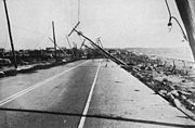
Impact
The majority of the storm damage was from storm surgeStorm surge
A storm surge is an offshore rise of water associated with a low pressure weather system, typically tropical cyclones and strong extratropical cyclones. Storm surges are caused primarily by high winds pushing on the ocean's surface. The wind causes the water to pile up higher than the ordinary sea...
and wind. Damage is estimated at $6 billion (2004 USD
United States dollar
The United States dollar , also referred to as the American dollar, is the official currency of the United States of America. It is divided into 100 smaller units called cents or pennies....
), making it among the most costly hurricanes to strike the U.S. mainland. It is estimated that if an identical hurricane struck today it would cause $39.2 billion (2005 USD) in damage.
Approximately 600 people died in the storm in New England, most in Rhode Island
Rhode Island
The state of Rhode Island and Providence Plantations, more commonly referred to as Rhode Island , is a state in the New England region of the United States. It is the smallest U.S. state by area...
, and up to 100 people elsewhere in the path of the storm. An additional 708 people were reported injured.
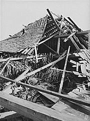
In total, 4,500 cottages, farms, and other homes were reported destroyed. An additional 25,000 homes were damaged. Other damages included 26,000 automobiles destroyed, and 20,000 electrical poles toppled. The hurricane also devastated the forests of the Northeast, knocking down an estimated 2 billion trees in New York and New England.
Freshwater flooding was minimal, however, as the quick passage of the storm decreased local rainfall totals, with only a few small areas receiving over 10 inches (250 mm).
Maryland and Delaware
The western periphery of the hurricane brought heavy rain and gusty winds to Delaware and southeastern Maryland. Damage, if any, is believed to have been minimal.New Jersey
The western side of the hurricane caused sustained tropical storm-force winds, high waves, and storm surge along much of the New Jersey coast. In Atlantic CityAtlantic City, New Jersey
Atlantic City is a city in Atlantic County, New Jersey, United States, and a nationally renowned resort city for gambling, shopping and fine dining. The city also served as the inspiration for the American version of the board game Monopoly. Atlantic City is located on Absecon Island on the coast...
, the surge destroyed much of the boardwalk. Additionally, the surge inundated several coastal communities; Wildwood
Wildwood, New Jersey
Wildwood is a city in Cape May County, New Jersey, United States. It is part of the Ocean City Metropolitan Statistical Area and is a popular summer resort destination. As of the 2010 United States Census, the city's year-round population was 5,325...
was under 3 foot (0.9144 m) of water at the height of the storm. The maximum recorded wind gust was 70 m.p.h. at Sandy Hook
Sandy Hook, New Jersey
Sandy Hook is a barrier spit, approximately 6.0 miles in length and varying between 0.10 and 1 miles wide in Middletown Township in Monmouth County, along the Atlantic Ocean coast of eastern New Jersey in the United States. The barrier spit encloses the southern entrance of Lower New York Bay...
.
New York
New York City received a glancing blow from the hurricane. Wind gusts up to 75 m.p.h. blew throughout Manhattan causing the East RiverEast River
The East River is a tidal strait in New York City. It connects Upper New York Bay on its south end to Long Island Sound on its north end. It separates Long Island from the island of Manhattan and the Bronx on the North American mainland...
to flow three blocks inland. The wind reportedly caused the Empire State Building
Empire State Building
The Empire State Building is a 102-story landmark skyscraper and American cultural icon in New York City at the intersection of Fifth Avenue and West 34th Street. It has a roof height of 1,250 feet , and with its antenna spire included, it stands a total of 1,454 ft high. Its name is derived...
to sway. Brooklyn, Queens, and Nassau counties, located on the western end of Long Island, were hammered with wind gusts in excess of 100 m.p.h., but escaped the worst of the wind and storm surge due to being on the storm's weaker west side. Power was lost throughout the city.
Eastern Long Island experienced the worst of the storm. The Dune Road area of Westhampton Beach
Westhampton Beach, New York
Westhampton Beach is an Incorporated Village in the town of Southampton, Suffolk County, New York, United States. As of the 2000 census, the village population was 1,902.-History:...
was obliterated, resulting in 29 deaths. A cinema in Westhampton was also swept out to sea; about 20 people at a matinee, and the theater — projectionist and all — landed two miles (3 km) into the Atlantic and drowned. There were 21 other deaths through the rest of the East End of Long Island. The storm surge temporarily turned Montauk
Montauk, New York
Montauk [ˈmɒntɒk] is a census-designated place that roughly corresponds to the hamlet with the same name located in the town of East Hampton in Suffolk County, New York, United States on the South Shore of Long Island. As of the United States 2000 Census, the CDP population was 3,851 as of 2000...
into an island as it flooded across the South Fork at Napeague
Napeague, New York
Napeague is a census-designated place that roughly corresponds to the hamlet with the same name in the town of East Hampton in Suffolk County, New York, United States...
and obliterated the tracks of the Long Island Rail Road
Long Island Rail Road
The Long Island Rail Road or LIRR is a commuter rail system serving the length of Long Island, New York. It is the busiest commuter railroad in North America, serving about 81.5 million passengers each year. Established in 1834 and having operated continuously since then, it is the oldest US...
. As a result of the hurricane, the Westhampton Beach School District changed its school's nickname from the Green Wave to the Hurricanes.
The surge rearranged the sand at the Cedar Point Lighthouse so that the island became connected to what is now Cedar Point County Park
Cedar Point County Park
Cedar Point County Park is a park in East Hampton, New York that is owned by the government of Suffolk County, New York. It has commanding views of Gardiners Bay and is famed for its decommissioned lighthouse.-History:...
. The surging water created the present-day Shinnecock Inlet
Shinnecock Inlet
Shinnecock Inlet is the easternmost of five major inlets connecting bays to the Atlantic Ocean through the narrow 100-mile-long Outer barrier that stretches from New York City to Southhampton, New York on the south shore of Long Island. It splits Westhampton Island from the peninsula extending from...
by carving out a large section of barrier island separating Shinnecock Bay from the Atlantic. The storm toppled the landmark steeple of the tallest building in Sag Harbor
Sag Harbor, New York
Sag Harbor is an incorporated village in Suffolk County, New York, United States, with parts in both the Towns of East Hampton and Southampton. The population was 2,313 at the 2000 census....
, the Old Whaler's Church
First Presbyterian Church (Sag Harbor)
First Presbyterian Church in Sag Harbor, New York, also known as Old Whaler's Church, is a historic and architecturally notable Presbyterian church built in 1844 in the Egyptian Revival style...
. The steeple has not been rebuilt. Wading River
Wading River, New York
Wading River is a hamlet in Suffolk County, New York, USA, on the North Shore of Long Island. As of the 2010 census, the CDP population was 7,719....
suffered substantial damage.
In Greenport, on the North Fork of Long Island, the storm blew down the movie theatre located on Front Street.
Rhode Island
The tide was even higher than usual because of the Autumnal Equinox and full moon
Full moon
Full moon lunar phase that occurs when the Moon is on the opposite side of the Earth from the Sun. More precisely, a full moon occurs when the geocentric apparent longitudes of the Sun and Moon differ by 180 degrees; the Moon is then in opposition with the Sun.Lunar eclipses can only occur at...
. The hurricane produced storm tides of 14 to 18 feet (5 m) across most of the Long Island and Connecticut coast, with 18- to 25 feet (8 m) tides from New London
New London, Connecticut
New London is a seaport city and a port of entry on the northeast coast of the United States.It is located at the mouth of the Thames River in New London County, southeastern Connecticut....
east to Cape Cod
Cape Cod
Cape Cod, often referred to locally as simply the Cape, is a cape in the easternmost portion of the state of Massachusetts, in the Northeastern United States...
. The storm surge was especially violent along the Rhode Island shore, sweeping hundreds of summer cottages out to sea. As the surge drove northward through Narragansett Bay
Narragansett Bay
Narragansett Bay is a bay and estuary on the north side of Rhode Island Sound. Covering 147 mi2 , the Bay forms New England's largest estuary, which functions as an expansive natural harbor, and includes a small archipelago...
, it was restricted by the Bay's funnel shape and rose to nearly 16 feet (15.8) feet above normal spring tides, resulting in more than 13 feet (4 m) of water in some areas of downtown Providence
Providence, Rhode Island
Providence is the capital and most populous city of Rhode Island and was one of the first cities established in the United States. Located in Providence County, it is the third largest city in the New England region...
. Several motorists were drowned in their autos. Due in part to the economic difficulties of the Great Depression
Great Depression
The Great Depression was a severe worldwide economic depression in the decade preceding World War II. The timing of the Great Depression varied across nations, but in most countries it started in about 1929 and lasted until the late 1930s or early 1940s...
many of the stores of downtown Providence were looted by mobs, often before the flood waters had fully subsided.
The impact of the storm was strong enough to be recorded on seismographs in California and Alaska.
Many homes and structures along the coast were destroyed, as well as many structures inland along the hurricane's path. Entire beach communities on the coast of Rhode Island were obliterated. Napatree Point
Napatree Point
Napatree Point, often referred to simply as "Napatree", is a long sandy spit created by a geologic process called longshore drift. Up until the Hurricane of 1938, Napatree was sickle-shaped and included a 1.5-mile long northern extension called Sandy Point...
, a small cape that housed nearly 40 families between the Atlantic Ocean
Atlantic Ocean
The Atlantic Ocean is the second-largest of the world's oceanic divisions. With a total area of about , it covers approximately 20% of the Earth's surface and about 26% of its water surface area...
and Little Narragansett Bay
Little Narragansett Bay
Little Narragansett Bay is an inlet of the Atlantic Ocean and an estuary of the Pawcatuck River on the Rhode Island-Connecticut state line. It is sheltered by a curving peninsula, known as Napatree Point. At the base of Napatree Point is the site of the resort village of Watch Hill, Rhode Island....
just off of Watch Hill, Rhode Island, was completely swept away. Today, Napatree is a wildlife refuge with no human inhabitants. One house in Charlestown was lifted and deposited across the street, where it stood, inhabited, until it was demolished in August 2011. The only structures lying directly on the coast that survived the storm were the immense stone mansions in Newport
Newport, Rhode Island
Newport is a city on Aquidneck Island in Newport County, Rhode Island, United States, about south of Providence. Known as a New England summer resort and for the famous Newport Mansions, it is the home of Salve Regina University and Naval Station Newport which houses the United States Naval War...
, mostly because the largest mansions were along the Cliff Walk, high above the waves, though several, including The Breakers
The Breakers
The Breakers is a Vanderbilt mansion located on Ochre Point Avenue, Newport, Rhode Island, United States on the Atlantic Ocean. It is a National Historic Landmark, a contributing property to the Bellevue Avenue Historic District, and is owned and operated by the Preservation Society of Newport...
and Carey Mansion
Carey Mansion
Carey Mansion, originally called Seaview Terrace, is a sprawling French Renaissance château located in Newport, Rhode Island. It was the last of the great "Summer Cottages” constructed, and is the fifth-largest of Newport's mansions — after The Breakers, Ochre Court, Belcourt Castle, and...
(known at that time as Seaview Terrace) still bear scars from the high winds of the storm.
A few miles from Conanicut Island, keeper Walter Eberle lost his life when Whale Rock
Whale Rock
Whale Rock/Submarine Rock is the smallest island in Narragansett Bay in Rhode Island.Submarine/Whale Rock is located in the West Passage of the bay, in Narragansett, Washington County, Rhode Island, west of the Beavertail area on Conanicut Island...
lighthouse was swept off its base and into the raging waves. His body was never found.
Connecticut
In the beach towns of Clinton
Clinton, Connecticut
Clinton is a town located on Long Island Sound in Middlesex County, Connecticut, United States. The population was 13,094 at the 2000 census. The town center along the shore line was listed as a census-designated place by the U.S...
, Westbrook
Westbrook, Connecticut
Westbrook is a town in Middlesex County, Connecticut, United States. The population was 6,292 at the 2000 census. The town center is also classified by the U.S. Census Bureau as a census-designated place .-Geography:...
, and Old Saybrook
Old Saybrook, Connecticut
Old Saybrook is a town in Middlesex County, Connecticut, United States. The population was 10,367 at the 2000 census. It contains the incorporated borough of Fenwick, as well as the census-designated places of Old Saybrook Center and Saybrook Manor.-History:...
, buildings were found as wreckage across coastal roads. Actress Katharine Hepburn
Katharine Hepburn
Katharine Houghton Hepburn was an American actress of film, stage, and television. In a career that spanned 62 years as a leading lady, she was best known for playing strong-willed, sophisticated women in both dramas and comedies...
waded to safety from her Old Saybrook beach home, narrowly escaping death. She stated in her 1991 book that 95% of her personal belongings were either lost or destroyed, including her 1932 Oscar which was later found intact. In Old Lyme
Old Lyme, Connecticut
Old Lyme is a town in New London County, Connecticut, United States. The Main Street of the town is a historic district. The town has long been a popular summer resort and artists' colony...
, beach cottages were flattened or swept away. Along the Stonington shorefront, buildings were swept off their foundations and found two miles (3 km) inland. Rescuers later searching for survivors in the homes in Mystic
Mystic, Connecticut
Mystic is a village and census-designated place in New London County, Connecticut, in the United States. The population was 4,001 at the 2000 census. A historic locality, Mystic has no independent government because it is not a legally recognized municipality in the state of Connecticut...
found live fish and crabs in kitchen drawers and cabinets.
New London
New London, Connecticut
New London is a seaport city and a port of entry on the northeast coast of the United States.It is located at the mouth of the Thames River in New London County, southeastern Connecticut....
was first swept by the winds and storm surge; then the waterfront business district caught fire and burned out of control for 10 hours. Stately homes along Ocean Beach were leveled by the storm surge. The permanently anchored 240-ton lightship at the head of New London Harbor was found on a sand bar two miles (3 km) away.
Interior sections of the state experienced widespread flooding as the hurricane's torrential rains fell on soil already saturated from previous storms. The Connecticut River
Connecticut River
The Connecticut River is the largest and longest river in New England, and also an American Heritage River. It flows roughly south, starting from the Fourth Connecticut Lake in New Hampshire. After flowing through the remaining Connecticut Lakes and Lake Francis, it defines the border between the...
was forced out of its banks, inundating cities and towns from Hartford
Hartford, Connecticut
Hartford is the capital of the U.S. state of Connecticut. The seat of Hartford County until Connecticut disbanded county government in 1960, it is the second most populous city on New England's largest river, the Connecticut River. As of the 2010 Census, Hartford's population was 124,775, making...
, to Middletown
Middletown, Connecticut
Middletown is a city located in Middlesex County, Connecticut, along the Connecticut River, in the central part of the state, 16 miles south of Hartford. In 1650, it was incorporated as a town under its original Indian name, Mattabeseck. It received its present name in 1653. In 1784, the central...
.
African-American novelist Ann Petry drew on her personal experiences of the hurricane in Old Saybrook in her 1947 novel, Country Place. Although the novel is set in the immediate aftermath of World War II, Petry identified the 1938 storm as the source for the storm that is at the center of her narrative.
Massachusetts
The eye of the storm followed the Connecticut River north into MassachusettsMassachusetts
The Commonwealth of Massachusetts is a state in the New England region of the northeastern United States of America. It is bordered by Rhode Island and Connecticut to the south, New York to the west, and Vermont and New Hampshire to the north; at its east lies the Atlantic Ocean. As of the 2010...
, where the winds and flooding killed 99 people. In Springfield, the river rose six to 10 feet (3 m) above flood stage, causing significant damage. Up to six inches (152 mm) of rain fell across western Massachusetts, which, combined with over four inches (102 mm) that had fallen a few days earlier, produced widespread flooding. In Chicopee
Chicopee, Massachusetts
Chicopee is a city located on the Connecticut River in Hampden County, Massachusetts, United States of America. It is part of the Springfield, Massachusetts Metropolitan Statistical Area. As of the 2010 census, the city had a total population of 55,298, making it the second largest city in...
, flash flooding on the Chicopee River washed away the Chicopee Falls Bridge, while the Connecticut River flooded most of the Willimansett section. Residents of Ware
Ware, Massachusetts
Ware is a town in Hampshire County, Massachusetts, United States. The population was 9,707 at the 2000 census. It is part of the Springfield, Massachusetts Metropolitan Statistical Area.Part of the town comprises the census-designated place of Ware....
were stranded for days and relied on air-dropped food and medicine. After the flood receded, the town's Main Street was a chasm in which sewer pipes could be seen.
To the east, the surge left Falmouth and New Bedford under eight feet of water. Two-thirds of all the boats in New Bedford harbor sank. The Blue Hill Observatory
Blue Hill Meteorological Observatory
The Blue Hill Meteorological Observatory, also known as Great Blue Hill Weather Observatory, Blue Hill Weather Observatory, or simply the Blue Hill Observatory, in Milton, Massachusetts is the foremost structure associated with the history of weather observations in the United States...
registered sustained winds of 121 mph (195 km/h) and a peak gust of 186 mph (299 km/h), which is the strongest hurricane-related surface wind gust ever recorded in the United States of America.
The New Haven Railroad from New Haven to Providence was particularly hard hit, as countless bridges along the Shore Line were destroyed or flooded, severing rail connections to badly affected cities (such as Westerly, Rhode Island) in the process.
Vermont
The hurricane slammed into VermontVermont
Vermont is a state in the New England region of the northeastern United States of America. The state ranks 43rd in land area, , and 45th in total area. Its population according to the 2010 census, 630,337, is the second smallest in the country, larger only than Wyoming. It is the only New England...
as a Category 1
Tropical cyclone
A tropical cyclone is a storm system characterized by a large low-pressure center and numerous thunderstorms that produce strong winds and heavy rain. Tropical cyclones strengthen when water evaporated from the ocean is released as the saturated air rises, resulting in condensation of water vapor...
storm at approximately 6:00 P.M. EST. Hurricane-force winds caused extensive damage to trees, buildings, and power lines. Over 2000 miles (3,218.7 km) of public roads were blocked, and it took months for crews to reopen some of the roads. Despite the damage, the storm killed only five people in Vermont. Until Hurricane Irene in 2011 (which had weakened to a tropical storm by the time it struck Vermont), the 1938 hurricane was the only tropical cyclone to make a direct hit on Vermont in its recorded history.
New Hampshire
Even though the storm center tracked further west through Vermont, New HampshireNew Hampshire
New Hampshire is a state in the New England region of the northeastern United States of America. The state was named after the southern English county of Hampshire. It is bordered by Massachusetts to the south, Vermont to the west, Maine and the Atlantic Ocean to the east, and the Canadian...
received appreciable damage. As in Vermont, very high winds brought down numerous trees and power lines, but rainfall totals in New Hampshire were significantly less than those in other states. Only one inch (25 mm) of rain fell in Concord
Concord, New Hampshire
The city of Concord is the capital of the state of New Hampshire in the United States. It is also the county seat of Merrimack County. As of the 2010 census, its population was 42,695....
. But damage at Peterborough
Peterborough, New Hampshire
Peterborough is a town in Hillsborough County, New Hampshire, United States. The population was 6,284 at the 2010 census. Home to the MacDowell Art Colony, the town is a popular tourist destination....
was worse; total damage there was stated to be $500,000 (1938 USD, $6.5 million 2005 USD), which included the destruction of 10 bridges. Much of the lower downtown burned because floodwaters prevented firefighters from reaching and extinguishing the blaze. Other communities also suffered considerable damage to forest resources. In New Hampshire, 13 people perished. At the Mt. Washington observatory, peak 5-minute sustained winds reached 136 m.p.h.
Maine
Damage in MaineMaine
Maine is a state in the New England region of the northeastern United States, bordered by the Atlantic Ocean to the east and south, New Hampshire to the west, and the Canadian provinces of Quebec to the northwest and New Brunswick to the northeast. Maine is both the northernmost and easternmost...
was mostly limited to fallen trees and power outages. Storm surge was minimal, and winds remained below hurricane strength. The storm did not claim any lives in Maine.
Quebec
As the hurricane was transitioning into an extratropical cycloneExtratropical cyclone
Extratropical cyclones, sometimes called mid-latitude cyclones or wave cyclones, are a group of cyclones defined as synoptic scale low pressure weather systems that occur in the middle latitudes of the Earth having neither tropical nor polar characteristics, and are connected with fronts and...
, it tracked into southern Quebec. When the system initially crossed into Canada, it continued to produce heavy rain and very strong winds, but interaction with land had taken its toll. Nevertheless, the hurricane managed to blow down numerous trees throughout the region. Otherwise, damage was generally minimal.
Post 1938 Hurricanes
In contrast to the long span of relatively mild hurricane activity that preceded the 1938 hurricane, subsequent storm activity would prove to be much more frequent. In the ensuing years following the storm, the northeastern United States would get hit with a number of hurricanes, notably the Great Atlantic Hurricane of 1944, Hurricane CarolHurricane Carol
Hurricane Carol was among the worst tropical cyclones to affect the New England region of the United States. It developed from a tropical wave near the Bahamas on August 25, 1954, and gradually strengthened as it moved northwestward. On August 27, Carol intensified to reach winds of , but weakened...
, Hurricane Edna
Hurricane Edna
Hurricane Edna was a deadly and destructive major hurricane that impacted the United States East Coast in September of the 1954 Atlantic hurricane season. It was one of two hurricanes to strike Massachusetts in that year, the other being Hurricane Carol...
, and Hurricane Hazel
Hurricane Hazel
Hurricane Hazel was the deadliest and costliest hurricane of the 1954 Atlantic hurricane season. The storm killed as many as 1,000 people in Haiti before striking the United States near the border between North and South Carolina, as a Category 4 hurricane...
in 1954, the flooding remnants of Hurricane Connie
Hurricane Connie
Hurricane Connie was the first in a series of hurricanes to strike North Carolina during the 1955 Atlantic hurricane season. Connie struck as a Category 1, causing major flooding and inflicting extensive damage to the Outer Banks and inland to Raleigh....
, Hurricane Diane
Hurricane Diane
Hurricane Diane was one of three hurricanes to hit North Carolina during the 1955 Atlantic hurricane season, striking an area that had been hit by Hurricane Connie five days earlier...
, Hurricane Ione
Hurricane Ione
Hurricane Ione was a strong, Category 3 hurricane that affected North Carolina in September 1955, bringing high winds and significant rainfall. It came on the heels of Hurricanes Connie and Diane, and compounded problems already caused by the two earlier hurricanes...
in 1955, Hurricane Donna
Hurricane Donna
Hurricane Donna in the 1960 Atlantic hurricane season was a Cape Verde-type hurricane which moved across the Leeward Islands, Puerto Rico, Hispanola, Cuba, The Bahamas, and every state on the East Coast of the United States...
in 1960, more recently Hurricane Gloria
Hurricane Gloria
Hurricane Gloria was a powerful Cape Verde-type hurricane that formed during the 1985 Atlantic hurricane season and prowled the Atlantic Ocean from September 16 to September 28. Gloria reached Category 4 status on the Saffir-Simpson Hurricane Scale near the Bahamas, but weakened significantly...
in 1985, and later Hurricane Bob
Hurricane Bob
Hurricane Bob was one of the costliest hurricanes in New England history. The second named storm and first hurricane of the 1991 Atlantic hurricane season, Bob developed from an area of low pressure near The Bahamas on August 16. The depression steadily intensified, and became Tropical Storm Bob...
in 1991 and Hurricane Irene
Hurricane Irene (2011)
Hurricane Irene was a large and powerful Atlantic hurricane that left extensive flood and wind damage along its path through the Caribbean, the United States East Coast and as far north as Atlantic Canada in 2011...
in 2011.
See also
- List of Atlantic hurricanes
- List of Category 5 Atlantic hurricanes
- List of New England hurricanes
- List of wettest tropical cyclones in Massachusetts
- List of Delaware hurricanes
External links
- http://www.pbs.org/wgbh/americanexperience/films/hurricane/An episode of the PBSPublic Broadcasting ServiceThe Public Broadcasting Service is an American non-profit public broadcasting television network with 354 member TV stations in the United States which hold collective ownership. Its headquarters is in Arlington, Virginia....
documentary series American ExperienceAmerican ExperienceAmerican Experience is a television program airing on the Public Broadcasting Service Public television stations in the United States. The program airs documentaries, many of which have won awards, about important or interesting events and people in American history...
originally aired in 2001 was dedicated to this hurricane]. - Damage from the hurricane
- National Hurricane Center, Brian R. Jarvinen Storm Tides in 12 Tropical Cyclones (including four intense New England hurricanes).
- State University of New York: Suffolk County Community College - History of Storm