
.gif)
Tropical Storm Isabel (1985)
Encyclopedia
Tropical Storm Isabel was the ninth tropical storm of the 1985 Atlantic hurricane season
. The storm's track extended from the Caribbean to the southeastern United States during the second week of October. Prior to developing into a tropical cyclone, it produced torrential rainfall, resulting in great damage and loss of life in Puerto Rico
. Isabel later made landfall in northeastern Florida
, and moved out to sea without producing great damage.
. Shortly after forming, the depression attained tropical storm status and received the name of Isabel, although further intensification was limited by interaction with the lands of the Dominican Republic
.
Located on the western edge of a mid-Atlantic high pressure system, Isabel moved northward over the Dominican Republic, and on the night of October 7, it moved northward through the southeastern Bahamas. Located over open waters, the storm quickly strengthened, and its winds reached a peak of 70 mph (110 km/h) late on the 8th, while to the northeast of the Bahamas. An approaching cold front
quickly weakened the storm, and a high pressure system behind the front pushed a weakened Isabel to the west-northwest and towards land.
.jpg) Convection steadily waned as it moved west-northwestward, and Isabel made landfall near Fernandina Beach, Florida
Convection steadily waned as it moved west-northwestward, and Isabel made landfall near Fernandina Beach, Florida
as a 40 mph (65 km/h) tropical storm late on October 10. It quickly weakened to a tropical depression, and Isabel remained near the Georgia
coastline until exiting near Savannah
late on the 11th. The depression drifted to the northeast, and Isabel remained a minimal tropical depression until being absorbed by a frontal trough on October 15 to the east of the Outer Banks
.
as a tropical wave. When it hit Florida
, damage was very minor due to its disorganization. Overall, the storm caused over $459 million in damage (1985 USD, $919 million 2008 USD) and at least 180 deaths.
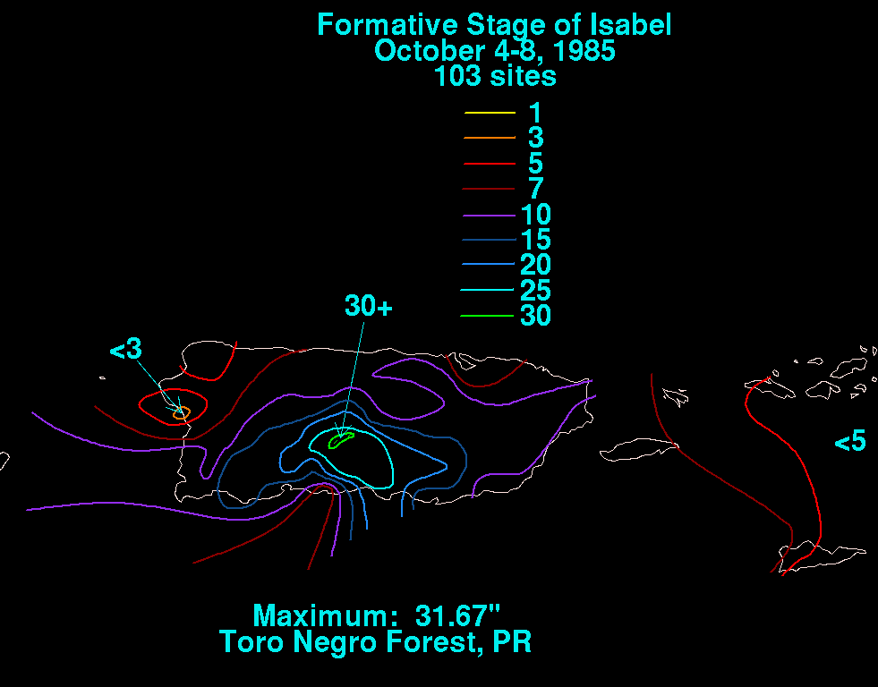
 An upper level trough to the west of the precursor tropical wave enhanced rainshower activity across the northeastern Caribbean Sea. Because of this, portions of Puerto Rico
experienced rainfall totals of 22 inches (560 mm) in 24 hours, while some areas received around 2.8 inches (70 mm) per hour. In the south-center portion of the island, rainfall peaked at 31.67 inches (805 mm). This deluge of rain came five months after another rainfall event, and resulted in widespread mudslides across the island.
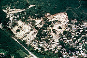
 One such landslide occurred in Mameyes
, a sector on the southern portion of the island in Ponce
, in barrio Portugues Urbano
. An entire sheet of bedrock
in the mountainous region outside of the city collapsed under the oversaturated soil, burying much of the community. The landslide was responsible for at least 129 deaths, and caused severe damage in the area. More than 100 homes were destroyed, and many others were later condemned due to soil instability. The mudslide, which by some estimates could have killed up to 300 people, is the worst landslide disaster in North American history.
Elsewhere on the island, at least 51 more people were killed from Isabel, though an exact total is unknown. The rainfall seriously damaged 8 bridges and 36 roads, and destroyed the approach slabs on one bridge in Coamo
, killing eight people when they drove their cars through the opening. Thirteen individuals perished in the El Tuque
portion of Ponce when a wall collapsed and flooded the area. In Santa Isabel
, nineteen bodies were retrieved from the Paso Seco River, which was close to overflowing. Also in town, another bridge was destroyed. The flooding also left 60 cities without power and 35,000 people without telephone service. Across the island, the storm damaged nearly 3,000 homes, leaving 4,400 homeless to be housed in 44 public shelters. Eleven water-filtration plants and 13 sewage treatment plants were closed following the storm, leaving 21% of the island without drinkable water. In all, the storm caused around $447 million (1985 USD, $895 million 2008 USD) in damage.
_rainfall_totals.gif) When Isabel made landfall on northeastern Florida
When Isabel made landfall on northeastern Florida
, the storm retained little convection. It dropped light rain along the southeastern United States coastline, peaking at 3.38 inches (85.9 mm) in southeastern North Carolina
. Overall, damage was relatively light.
passed a resolution to provide Puerto Rico with all necessary assistance in the cleanup. Days later, President Ronald Reagan
declared the island as a Federal Disaster Area at the request of Puerto Rico
Governor Rafael Hernández Colón
. A memorial service with some 3,000 people attending was held for 23 of the casualties, and a memorial park was proposed to be built where the landslide ravine was. The Federal Emergency Management Agency
(FEMA) provided $63 million (1985 USD, $126 million 2008 USD) in aid.
1985 Atlantic hurricane season
The 1985 Atlantic hurricane season had the most U.S. landfalling tropical cyclones since 1916. The season officially began on June 1, 1985, and lasted until November 30, 1985...
. The storm's track extended from the Caribbean to the southeastern United States during the second week of October. Prior to developing into a tropical cyclone, it produced torrential rainfall, resulting in great damage and loss of life in Puerto Rico
Puerto Rico
Puerto Rico , officially the Commonwealth of Puerto Rico , is an unincorporated territory of the United States, located in the northeastern Caribbean, east of the Dominican Republic and west of both the United States Virgin Islands and the British Virgin Islands.Puerto Rico comprises an...
. Isabel later made landfall in northeastern Florida
Florida
Florida is a state in the southeastern United States, located on the nation's Atlantic and Gulf coasts. It is bordered to the west by the Gulf of Mexico, to the north by Alabama and Georgia and to the east by the Atlantic Ocean. With a population of 18,801,310 as measured by the 2010 census, it...
, and moved out to sea without producing great damage.
Meteorological history
A tropical wave moved off the coast of Africa on September 29. As it moved westward across the Atlantic Ocean, the wave entered the eastern Caribbean on October 5. On October 7, an area of disturbed weather on the northern edges of the wave organized into a tropical depression while south of HispaniolaHispaniola
Hispaniola is a major island in the Caribbean, containing the two sovereign states of the Dominican Republic and Haiti. The island is located between the islands of Cuba to the west and Puerto Rico to the east, within the hurricane belt...
. Shortly after forming, the depression attained tropical storm status and received the name of Isabel, although further intensification was limited by interaction with the lands of the Dominican Republic
Dominican Republic
The Dominican Republic is a nation on the island of La Hispaniola, part of the Greater Antilles archipelago in the Caribbean region. The western third of the island is occupied by the nation of Haiti, making Hispaniola one of two Caribbean islands that are shared by two countries...
.
Located on the western edge of a mid-Atlantic high pressure system, Isabel moved northward over the Dominican Republic, and on the night of October 7, it moved northward through the southeastern Bahamas. Located over open waters, the storm quickly strengthened, and its winds reached a peak of 70 mph (110 km/h) late on the 8th, while to the northeast of the Bahamas. An approaching cold front
Cold front
A cold front is defined as the leading edge of a cooler mass of air, replacing a warmer mass of air.-Development of cold front:The cooler and denser air wedges under the less-dense warmer air, lifting it...
quickly weakened the storm, and a high pressure system behind the front pushed a weakened Isabel to the west-northwest and towards land.
Fernandina Beach, Florida
Fernandina Beach is a city in Nassau County in the state of Florida in the United States of America and on Amelia Island. It is a part of Greater Jacksonville and is among Florida's northernmost cities. The area was first inhabited by the Timucuan Indian tribe...
as a 40 mph (65 km/h) tropical storm late on October 10. It quickly weakened to a tropical depression, and Isabel remained near the Georgia
Georgia (U.S. state)
Georgia is a state located in the southeastern United States. It was established in 1732, the last of the original Thirteen Colonies. The state is named after King George II of Great Britain. Georgia was the fourth state to ratify the United States Constitution, on January 2, 1788...
coastline until exiting near Savannah
Savannah, Georgia
Savannah is the largest city and the county seat of Chatham County, in the U.S. state of Georgia. Established in 1733, the city of Savannah was the colonial capital of the Province of Georgia and later the first state capital of Georgia. Today Savannah is an industrial center and an important...
late on the 11th. The depression drifted to the northeast, and Isabel remained a minimal tropical depression until being absorbed by a frontal trough on October 15 to the east of the Outer Banks
Outer Banks
The Outer Banks is a 200-mile long string of narrow barrier islands off the coast of North Carolina, beginning in the southeastern corner of Virginia Beach on the east coast of the United States....
.
Impact
Heavy rainfall caused great damage and loss of life in Puerto RicoPuerto Rico
Puerto Rico , officially the Commonwealth of Puerto Rico , is an unincorporated territory of the United States, located in the northeastern Caribbean, east of the Dominican Republic and west of both the United States Virgin Islands and the British Virgin Islands.Puerto Rico comprises an...
as a tropical wave. When it hit Florida
Florida
Florida is a state in the southeastern United States, located on the nation's Atlantic and Gulf coasts. It is bordered to the west by the Gulf of Mexico, to the north by Alabama and Georgia and to the east by the Atlantic Ocean. With a population of 18,801,310 as measured by the 2010 census, it...
, damage was very minor due to its disorganization. Overall, the storm caused over $459 million in damage (1985 USD, $919 million 2008 USD) and at least 180 deaths.
Puerto Rico
Puerto Rico
Puerto Rico , officially the Commonwealth of Puerto Rico , is an unincorporated territory of the United States, located in the northeastern Caribbean, east of the Dominican Republic and west of both the United States Virgin Islands and the British Virgin Islands.Puerto Rico comprises an...
experienced rainfall totals of 22 inches (560 mm) in 24 hours, while some areas received around 2.8 inches (70 mm) per hour. In the south-center portion of the island, rainfall peaked at 31.67 inches (805 mm). This deluge of rain came five months after another rainfall event, and resulted in widespread mudslides across the island.
Portugués Urbano
Portugués Urbano is one of the 31 barrios in the municipality of Ponce, Puerto Rico. Along with Canas Urbano, Machuelo Abajo, Magueyes Urbano, and San Antón, Portugués Urbano is one of the municipality's five originally rural barrios that are now also part of the urban zone of the city of...
, a sector on the southern portion of the island in Ponce
Ponce, Puerto Rico
Ponce is both a city and a municipality in the southern part of Puerto Rico. The city is the seat of the municipal government.The city of Ponce, the fourth most populated in Puerto Rico, and the most populated outside of the San Juan metropolitan area, is named for Juan Ponce de León y Loayza, the...
, in barrio Portugues Urbano
Portugués Urbano
Portugués Urbano is one of the 31 barrios in the municipality of Ponce, Puerto Rico. Along with Canas Urbano, Machuelo Abajo, Magueyes Urbano, and San Antón, Portugués Urbano is one of the municipality's five originally rural barrios that are now also part of the urban zone of the city of...
. An entire sheet of bedrock
Bedrock
In stratigraphy, bedrock is the native consolidated rock underlying the surface of a terrestrial planet, usually the Earth. Above the bedrock is usually an area of broken and weathered unconsolidated rock in the basal subsoil...
in the mountainous region outside of the city collapsed under the oversaturated soil, burying much of the community. The landslide was responsible for at least 129 deaths, and caused severe damage in the area. More than 100 homes were destroyed, and many others were later condemned due to soil instability. The mudslide, which by some estimates could have killed up to 300 people, is the worst landslide disaster in North American history.
Elsewhere on the island, at least 51 more people were killed from Isabel, though an exact total is unknown. The rainfall seriously damaged 8 bridges and 36 roads, and destroyed the approach slabs on one bridge in Coamo
Coamo, Puerto Rico
Coamo is a municipality in Puerto Rico located in the southern region, north of Santa Isabel; south of Orocovis and Barranquitas; east of Villalba and Juana Díaz; and west of Aibonito and Salinas. Coamo is spread over 10 wards and Coamo Pueblo...
, killing eight people when they drove their cars through the opening. Thirteen individuals perished in the El Tuque
El Tuque
El Tuque is a beach and family recreational and tourist complex in the Punta Cucharas sector of Ponce, Puerto Rico. It was designed in the early 1960s by Luis Flores, an architect from Cayey, Puerto Rico. It is located on PR-2, Km 220.1, in the El Tuque sector of Barrio Canas in Ponce...
portion of Ponce when a wall collapsed and flooded the area. In Santa Isabel
Santa Isabel, Puerto Rico
Santa Isabel is a municipality of Puerto Rico located in the southern coast, south of Coamo; east of Juana Díaz; and west of Salinas. Santa Isabel is spread over 7 wards and Santa Isabel Pueblo...
, nineteen bodies were retrieved from the Paso Seco River, which was close to overflowing. Also in town, another bridge was destroyed. The flooding also left 60 cities without power and 35,000 people without telephone service. Across the island, the storm damaged nearly 3,000 homes, leaving 4,400 homeless to be housed in 44 public shelters. Eleven water-filtration plants and 13 sewage treatment plants were closed following the storm, leaving 21% of the island without drinkable water. In all, the storm caused around $447 million (1985 USD, $895 million 2008 USD) in damage.
Southeast United States
Florida
Florida is a state in the southeastern United States, located on the nation's Atlantic and Gulf coasts. It is bordered to the west by the Gulf of Mexico, to the north by Alabama and Georgia and to the east by the Atlantic Ocean. With a population of 18,801,310 as measured by the 2010 census, it...
, the storm retained little convection. It dropped light rain along the southeastern United States coastline, peaking at 3.38 inches (85.9 mm) in southeastern North Carolina
North Carolina
North Carolina is a state located in the southeastern United States. The state borders South Carolina and Georgia to the south, Tennessee to the west and Virginia to the north. North Carolina contains 100 counties. Its capital is Raleigh, and its largest city is Charlotte...
. Overall, damage was relatively light.
Aftermath
Just days after the storm, the United States House of RepresentativesUnited States House of Representatives
The United States House of Representatives is one of the two Houses of the United States Congress, the bicameral legislature which also includes the Senate.The composition and powers of the House are established in Article One of the Constitution...
passed a resolution to provide Puerto Rico with all necessary assistance in the cleanup. Days later, President Ronald Reagan
Ronald Reagan
Ronald Wilson Reagan was the 40th President of the United States , the 33rd Governor of California and, prior to that, a radio, film and television actor....
declared the island as a Federal Disaster Area at the request of Puerto Rico
Puerto Rico
Puerto Rico , officially the Commonwealth of Puerto Rico , is an unincorporated territory of the United States, located in the northeastern Caribbean, east of the Dominican Republic and west of both the United States Virgin Islands and the British Virgin Islands.Puerto Rico comprises an...
Governor Rafael Hernández Colón
Rafael Hernández Colón
Rafael Hernández Colón is a Puerto Rican politician who served as the fourth Governor of the Commonwealth of Puerto Rico for three non-consecutive terms, from 1973 to 1977 and from 1985 to 1993. An experienced politician, Hernández holds the record for being the youngest Governor of Puerto Rico,...
. A memorial service with some 3,000 people attending was held for 23 of the casualties, and a memorial park was proposed to be built where the landslide ravine was. The Federal Emergency Management Agency
Federal Emergency Management Agency
The Federal Emergency Management Agency is an agency of the United States Department of Homeland Security, initially created by Presidential Reorganization Plan No. 1 of 1978 and implemented by two Executive Orders...
(FEMA) provided $63 million (1985 USD, $126 million 2008 USD) in aid.
See also
- List of tropical cyclones
- List of Atlantic hurricanes
External links
- [ftp://ftp.nhc.noaa.gov/pub/storm_archives/atlantic/prelimat/atl1985/isabel/ Isabel's Tropical Cyclone Report from NHC]
- Isabel's Rainfall Report from HPC
- 1985 MWR
- Puerto Rican Landslide information
- More P.R. information
- Puerto Rico Hurricanes and Tropical Storms