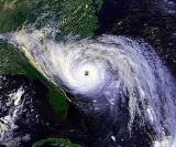
All Topics  
Hurricane Hugo

 
Hurricane Hugo

   Email Print
   Bookmark   Link


Hurricane Hugo


Hurricane Hugo was a destructive Category 5
Saffir-Simpson Hurricane Scale

The Saffir-Simpson Hurricane Scale is a classification used for most Western Hemisphere tropical cyclones that exceed the intensities of tropical depressions and tropical storms, and thereby become hurricanes....
 hurricane that struck Guadeloupe
Guadeloupe

Guadeloupe is an island group or archipelago located in the eastern Caribbean Sea at , with a land area of 1,628 square kilometres . It is an overseas department of France....
, Montserrat
Montserrat

Montserrat is British overseas territory located in the Leeward Islands, part of the chain of islands called the Lesser Antilles in the Caribbean Sea....
, Puerto Rico
Puerto Rico

Puerto Rico , officially the Commonwealth of Puerto Rico , is a Autonomy Territories of the United States of the United States located in the northeastern Caribbean, east of the Dominican Republic and west of the Virgin Islands....
, St. Croix, South Carolina
South Carolina

South Carolina is a U.S. state in the Southern United States of the United States. It borders Georgia to the south and North Carolina to the north....
 and North Carolina
North Carolina

North Carolina is a U.S. state located on the Atlantic Seaboard in the southeastern United States. The state borders South Carolina and Georgia to the south, Tennessee to the west and Virginia to the north....
 in September of the 1989 Atlantic hurricane season
1989 Atlantic hurricane season

The 1989 Atlantic hurricane season officially began on June 1, 1989, and lasted until November 30, 1989. These dates conventionally delimit the period of each year when most tropical cyclones form in the Atlantic basin....
, killing 56 people and leaving 56,000 homeless.

Hugo developed from a tropical wave
Tropical wave

Tropical waves, or easterly waves, also known as African easterly waves in the Atlantic region, are a type of atmospheric Trough , an elongated area of relatively Low pressure area, oriented north to south, which move from east to west across the tropics causing areas of cloudiness and thunderstorms....
 that moved off the coast of Africa on September 9th. The storm tracked westward, and became a tropical storm on the 11th, and a hurricane on the 13th. It reached its peak intensity as a Category 5 hurricane, and moved toward the United States
United States

The United States of America is a Federal government constitutional republic comprising U.S. state and a federal district. The country is situated mostly in central North America, where its Contiguous United States and Washington, D.C., the Capital districts and territories, lie between the Pacific Ocean and Atlantic Oceans, Borders of the U...
.


Discussion
Ask a question about 'Hurricane Hugo'
Start a new discussion about 'Hurricane Hugo'
Answer questions from other users
Full Discussion Forum


Encyclopedia


Hurricane Hugo was a destructive Category 5
Saffir-Simpson Hurricane Scale

The Saffir-Simpson Hurricane Scale is a classification used for most Western Hemisphere tropical cyclones that exceed the intensities of tropical depressions and tropical storms, and thereby become hurricanes....
 hurricane that struck Guadeloupe
Guadeloupe

Guadeloupe is an island group or archipelago located in the eastern Caribbean Sea at , with a land area of 1,628 square kilometres . It is an overseas department of France....
, Montserrat
Montserrat

Montserrat is British overseas territory located in the Leeward Islands, part of the chain of islands called the Lesser Antilles in the Caribbean Sea....
, Puerto Rico
Puerto Rico

Puerto Rico , officially the Commonwealth of Puerto Rico , is a Autonomy Territories of the United States of the United States located in the northeastern Caribbean, east of the Dominican Republic and west of the Virgin Islands....
, St. Croix, South Carolina
South Carolina

South Carolina is a U.S. state in the Southern United States of the United States. It borders Georgia to the south and North Carolina to the north....
 and North Carolina
North Carolina

North Carolina is a U.S. state located on the Atlantic Seaboard in the southeastern United States. The state borders South Carolina and Georgia to the south, Tennessee to the west and Virginia to the north....
 in September of the 1989 Atlantic hurricane season
1989 Atlantic hurricane season

The 1989 Atlantic hurricane season officially began on June 1, 1989, and lasted until November 30, 1989. These dates conventionally delimit the period of each year when most tropical cyclones form in the Atlantic basin....
, killing 56 people and leaving 56,000 homeless.

Hugo developed from a tropical wave
Tropical wave

Tropical waves, or easterly waves, also known as African easterly waves in the Atlantic region, are a type of atmospheric Trough , an elongated area of relatively Low pressure area, oriented north to south, which move from east to west across the tropics causing areas of cloudiness and thunderstorms....
 that moved off the coast of Africa on September 9th. The storm tracked westward, and became a tropical storm on the 11th, and a hurricane on the 13th. It reached its peak intensity as a Category 5 hurricane, and moved toward the United States
United States

The United States of America is a Federal government constitutional republic comprising U.S. state and a federal district. The country is situated mostly in central North America, where its Contiguous United States and Washington, D.C., the Capital districts and territories, lie between the Pacific Ocean and Atlantic Oceans, Borders of the U...
. Hugo made landfall in South Carolina as a Category 4.

The storm caused $10 billion (1989 USD, $16.3 billion (2006 USD
United States dollar

The United States dollar is the unit of currency of the United States and was defined by the Coinage Act of 1792 to be between 371 and 416 grains of silver ....
) in damages, making it the most damaging hurricane ever recorded up to that time, surpassing Hurricane Frederic
Hurricane Frederic

Hurricane Frederic was the sixth tropical cyclone, third hurricane and second major hurricane of the 1979 Atlantic hurricane season. Frederic was the costliest and first hurricanes to ever hit the U.S....
. Hugo was itself surpassed by Hurricane Andrew
Hurricane Andrew

Hurricane Andrew is the second most powerful, and the last of three Saffir-Simpson Hurricane Scale hurricanes that made U.S. landfall during the 20th century, after the Labor Day Hurricane of 1935 and Hurricane Camille in 1969....
 three years later, which was eventually surpassed by Hurricane Katrina
Hurricane Katrina

Hurricane Katrina of the 2005 Atlantic hurricane season was the costliest Atlantic hurricane, as well as one of the five deadliest, in the history of the United States....
 in 2005 and Hurricane Ike
Hurricane Ike

Hurricane Ike IPA] was the third most destructive hurricane to ever make landfall in the United States. It was the ninth named storm, fifth hurricane and third major hurricane of the 2008 Atlantic hurricane season....
 in 2008.

Meteorological history

Hugo's origins were from a cluster of thunderstorms that moved off the coast of Africa on September 9th. On a westward track, Hugo steadily intensified, becoming a tropical storm on the 11th, and a Hurricane on the 13th. Hugo reached its peak intensity while several miles to the east of Puerto Rico
Puerto Rico

Puerto Rico , officially the Commonwealth of Puerto Rico , is a Autonomy Territories of the United States of the United States located in the northeastern Caribbean, east of the Dominican Republic and west of the Virgin Islands....
.

Hugo began to execute a more north-northwest track, still intensifying as it did so. On the 17th, Hugo's eye was over Guadeloupe. Shortly thereafter, Hugo accelerated to the north-nothwest, and by the 19th, Hugo was located to the north of Puerto Rico. On the 18th, Hugo was located a couple hundred miles east of Florida
Florida

Florida is a U.S. state located in the Southeastern United States of the United States, bordering Alabama to the northwest and Georgia to the northeast....
, when it began a more northward track, in response to a steering flow that was associated with a low pressure system that was moving across the United States
United States

The United States of America is a Federal government constitutional republic comprising U.S. state and a federal district. The country is situated mostly in central North America, where its Contiguous United States and Washington, D.C., the Capital districts and territories, lie between the Pacific Ocean and Atlantic Oceans, Borders of the U...
.

Hugo moved toward the northwest, and made landfall on the Isle of Palms, South Carolina, as a Category 4 on the Saffir-Simpson hurricane scale
Saffir-Simpson Hurricane Scale

The Saffir-Simpson Hurricane Scale is a classification used for most Western Hemisphere tropical cyclones that exceed the intensities of tropical depressions and tropical storms, and thereby become hurricanes....
 on September 22nd. The storm continued inland, and weakend to a tropical storm later that day. The storm continued weakening as it moved inland, and on September 23rd, the storm was making its transition into a remnant low.

Preparations

Savannah
Savannah, Georgia

Savannah is the largest city in, and the county seat of, Chatham County, Georgia, Georgia , United States. Savannah was established in 1733 and was the first colonial and state capital of Georgia....
 was evacuated in anticipation of Hugo, but saw no effects of the storm other than isolated and light showers. Had Hugo hit Savannah, it would have been the first major hurricane to make landfall in Georgia
Georgia (U.S. state)

Georgia is a U.S. state in the United States and was one of the original Thirteen Colonies that revolted against United Kingdom rule in the American Revolution....
 since Storm 7 of the 1898 season
1898 Atlantic hurricane season

The 1898 Atlantic hurricane season ran through the summer and the first half of fall in 1898. The season was a fairly active one, with 11 storms forming, 4 of which became hurricanes....
. Governor Carroll Campbell of South Carolina
South Carolina

South Carolina is a U.S. state in the Southern United States of the United States. It borders Georgia to the south and North Carolina to the north....
 ordered an evacuation of the South Carolina coast in advance of the storm.

Impact

Storm deaths by region
(estimates)
Region Deaths
United States
United States

The United States of America is a Federal government constitutional republic comprising U.S. state and a federal district. The country is situated mostly in central North America, where its Contiguous United States and Washington, D.C., the Capital districts and territories, lie between the Pacific Ocean and Atlantic Oceans, Borders of the U...
 
35
Puerto Rico
Puerto Rico

Puerto Rico , officially the Commonwealth of Puerto Rico , is a Autonomy Territories of the United States of the United States located in the northeastern Caribbean, east of the Dominican Republic and west of the Virgin Islands....
 
12
Guadeloupe
Guadeloupe

Guadeloupe is an island group or archipelago located in the eastern Caribbean Sea at , with a land area of 1,628 square kilometres . It is an overseas department of France....
 
13
Montserrat
Montserrat

Montserrat is British overseas territory located in the Leeward Islands, part of the chain of islands called the Lesser Antilles in the Caribbean Sea....
 
22
Virgin Islands
Virgin Islands

The Virgin Islands are an archipelago, part of the Leeward Islands in the Caribbean Sea. The Leeward Islands are the northern islands of the Lesser Antilles, where the Caribbean Sea meets the western Atlantic Ocean....
 
6
Antigua and Barbuda
Antigua and Barbuda

Antigua and Barbuda is an island nation located on the eastern boundary of the Caribbean Sea with the Atlantic Ocean. As its name suggests, it consists of two major islands Antigua and Barbuda as well as a number of smaller islets....
 
10
Saint Kitts and Nevis

The Federation of Saint Kitts and Nevis , located in the Leeward Islands, is a federal two-island nation in the West Indies. It is the smallest nation in the Americas, in both List of countries by area and List of countries by population....
 
11
Total 109


Hugo caused $7 billion (1989 USD
United States dollar

The United States dollar is the unit of currency of the United States and was defined by the Coinage Act of 1792 to be between 371 and 416 grains of silver ....
) in damage in the mainland United States
United States

The United States of America is a Federal government constitutional republic comprising U.S. state and a federal district. The country is situated mostly in central North America, where its Contiguous United States and Washington, D.C., the Capital districts and territories, lie between the Pacific Ocean and Atlantic Oceans, Borders of the U...
. At the time it was the costliest hurricane in U.S. history, but was exceeded in 1992 by Hurricane Andrew
Hurricane Andrew

Hurricane Andrew is the second most powerful, and the last of three Saffir-Simpson Hurricane Scale hurricanes that made U.S. landfall during the 20th century, after the Labor Day Hurricane of 1935 and Hurricane Camille in 1969....
, and by three other storms since then. It remains the sixth costliest hurricane in U.S. history. An additional $3 billion of damages was reported throughout the Caribbean. Therefore, total damages from the storm were $10 billion (1989 USD
United States dollar

The United States dollar is the unit of currency of the United States and was defined by the Coinage Act of 1792 to be between 371 and 416 grains of silver ....
).

Sources differ on the number of people killed by Hugo, with some citing the American Meteorological Society
American Meteorological Society

The American Meteorological Society promotes the development and dissemination of information and education on the Atmospheric sciences and related Oceanography and Hydrology and the advancement of their professional applications....
's figure of 49, and others claiming 56 deaths . Some government agency sources claim only 32 deaths in the United States.

Caribbean

Severe damage was reported throughout the islands of the Caribbean. The storm caused an estimated $5 billion (1989 US dollars) in damages in the Caribbean (including $1 billion in Puerto Rico and the USVI.)

St. Croix
There was massive looting and unrest, prompting President George H.W. Bush to send troops to St. Croix in Operation Hawkeye. It also resulted in the first operational deployment of the National Disaster Medical System (NDMS), when the New Mexico-1 Disaster Medical Assistance Team (DMAT)was deployed to assist in medical care needs of the stricken island.


Guadeloupe

There was very extensive damages in Guadeloupe, mostly in Grande-Terre
Grande-Terre

The main part of Guadeloupe consists of two islands separated by a salt river and whose combined shape resembles a butterfly. The western island is Basse-Terre Island and the eastern island is Grande-Terre....
. 10.000 houses were completely destroyed, with 30% of buildings suffering great damages including business, hotels, schools and churches. Banana crops were also destroyed at 100% and sugarcanes crops suffered 60% damages. 13 were killed and 35,000 were left homeless. Total damages estimated to be between 250 and 350 millions U.S. Dollar.

Raizet Airport had a 90 mph (144 km/h) sustained winds and a 117 mph (187 km/h) sustained gust. Minimal pressure fell to 943 mb (27.85 In Hg) as the eye passed after midnight.

In a navy boat in Pointe-a-Pitre
Pointe-à-Pitre

Pointe-?-Pitre is the largest city of Guadeloupe, an overseas region and Overseas department of France located in the Lesser Antilles, of which it is a Subprefectures in France, being the seat of the Arrondissement of Pointe-?-Pitre....
 bay, gust reported to reach 184 mph (296 km/h) and unofficials station reached 200 mph (320 km/h) in Grande-Terre.

Hurricane Hugo may have been one of the worst hurricanes to strike the islands since Hurricane Flora
Hurricane Flora

Hurricane Flora is among the List of deadliest Atlantic hurricanes Atlantic hurricanes in recorded history, with a death total of over 7,000. The seventh tropical storm and sixth hurricane of the 1963 Atlantic hurricane season, Flora developed from a disturbance in the Intertropical Convergence Zone on September 26 while located about southw...
 in 1963, along with other storms in 1979
Hurricane David

Hurricane David was the fourth named tropical cyclone, second hurricane, and first major hurricane of the 1979 Atlantic hurricane season. A Category 5 hurricane on the Saffir-Simpson Hurricane Scale, David was among the deadliest hurricanes in the latter half of the 20th century, killing over 2,000 people in its path, mostly in the...
, 1995
Hurricane Luis

Hurricane Luis was the twelfth named tropical cyclone and one of the most powerful storms during the very busy 1995 Atlantic hurricane season. The rare, large and long-lived Cape Verde-type hurricane lasted for 16 days during August and September....
 and 1999
Hurricane Lenny

Hurricane Lenny was the 12th tropical storm, eighth tropical cyclone, and fifth major hurricane in the 1999 Atlantic hurricane season. Lenny was the strongest Atlantic hurricane ever recorded in November, and quite unusual in that it moved west-to-east across the Caribbean....
.

Montserrat

90% of all structures were destroyed in the British overseas territory, including the island's hospital and virtually all the homes of its 12,000 residents. Tourism and agriculture were also severely hit. Total damage was estimated at $100-300 million dollars (1989 USD
United States dollar

The United States dollar is the unit of currency of the United States and was defined by the Coinage Act of 1792 to be between 371 and 416 grains of silver ....
); the island became reliant on aid as a result.

Additionally, the local bat population was devastated, with an estimated 90% decrease in numbers following Hugo's passage. The species Chiroderma improvisum has not been seen on Montserrat since, and it is feared that it may be extinct on the island.

Puerto Rico

Damage in Puerto Rico was severe, especially in the eastern part of the island. The agricultural sector was devastated, with the banana and coffee crops being almost completely wiped out. Heavy rains caused severe flooding in the vicinity of San Juan
San Juan, Puerto Rico

San Juan is the Capital and largest Municipalities of Puerto Rico in Puerto Rico. As of the United States Census Bureau, it has a population of 433,733, making it the List of United States cities by population city under the jurisdiction of the United States....
; in addition, several roads and bridges were washed away.

In all, 12 deaths in Puerto Rico are attributed to Hugo, six of which occurred in the southern city of Guayama where some residents were electrocuted by downed power lines. Nearly 28,000 people were left homeless by the storm.

United States


South Carolina
Hurricane Hugo Mobile Home Damage
Hurricane Hugo Beach Front Damage
While downtown Charleston, South Carolina
Charleston, South Carolina

Charleston is a city in Charleston County, South Carolina in the U.S. state of South Carolina. It is the largest city and county seat of Charleston County....
 suffered extensive damage, the greatest damage was reported in the surrounding suburbs of Mount Pleasant
Mount Pleasant, South Carolina

Mount Pleasant is a suburban town in Charleston County, South Carolina, South Carolina, United States, within the Charleston, South Carolina–North Charleston, South Carolina–Summerville, South Carolina Charleston-North Charleston-Summerville metropolitan area....
, Sullivan's Island
Sullivan's Island, South Carolina

Sullivan's Island is a town in Charleston County, South Carolina, South Carolina, United States, on a similarly-named island at the entrance to Charleston Harbor....
, Isle of Palms
Isle of Palms, South Carolina

Isle of Palms is a city in Charleston County, South Carolina, South Carolina, United States. As of the 2000 census, the population on the island was 4,583....
, and Goose Creek
Goose Creek, South Carolina

Goose Creek is a city in Berkeley County, South Carolina and Charleston County, South Carolina counties in the U.S. state of South Carolina. The population was 29,208 at the United States Census, 2000....
. Sullivan's Island and the Isle of Palms were cut off from the mainland by the storm's destruction of the Ben Sawyer Bridge. Along the coast, Hugo destroyed many houses and the storm surge piled boats on top of each other.

The storm's most intense wind and storm surge
Storm surge

Storm surge is an offshore rise of water associated with a low pressure area weather system, typically a tropical cyclone. Storm surge is caused primarily by high winds pushing on the ocean's surface....
 came ashore still further north between the small towns of Awendaw
Awendaw, South Carolina

Awendaw is a town in Charleston County, South Carolina, South Carolina, United States. The population was 1,195 at the 2000 census. It is part of the Charleston, South Carolina–North Charleston, South Carolina–Summerville, South Carolina Charleston-North Charleston-Summerville metropolitan area....
 and McClellanville
McClellanville, South Carolina

McClellanville is a town in Charleston County, South Carolina, South Carolina, United States. The population was 459 at the 2000 census. It is part of the Charleston, South Carolina–North Charleston, South Carolina–Summerville, South Carolina Charleston-North Charleston-Summerville metropolitan area....
. An extraordinary 20-foot storm surge was reported between Cape Romain and Bulls Bay. Most mature trees in the Francis Marion National Forest
Francis Marion National Forest

The Francis Marion National Forest is located north of Charleston, South Carolina. It is named for revolutionary war hero Francis Marion, who was known to the British as the Swamp Fox....
 were uprooted. Many of the stands were old growth longleaf pine
Longleaf Pine

The Longleaf Pine is a pine native to the southeast United States, found along the coastal plain from eastern Texas to southeast Virginia extending into northern and central Florida....
, an important habitat for some endangered species
Endangered species

An endangered species is a population of an organism which is at risk of becoming extinct because it is either few in numbers, or threatened by changing environmental or predation parameters....
. In McClellanville, a small fishing town, residents took refuge in Lincoln High School, and were surprised by the sudden tidal surge which flooded the school. With water pouring into the rooms, the refugees helped one another in pitch darkness to climb into the space in the hanging ceiling above the rooms. All survived.

The Myrtle Beach & Surfside Beach/Garden City/Murrells Inlet areas also took quite a hit from the storm, not so much from wind, but mainly with storm surge. The surge plus the fact that Hugo hit the area at high tide, created a 12 to 14 foot surge. Many beach-front homes built in these areas were destroyed, leaving numerous ones laying across the middle of Ocean Blvd throughout Surfside Beach & Garden City. Telephone poles were standing in a 45 degree angle, and the boulevard was covered in approximately 4 feet of sand. Many homes just blocks from the beach were untouched.

According to Governor
Governor of South Carolina

The Governor of the State of South Carolina is the head of state for the South Carolina. Under the South Carolina Constitution, the Governor is also the head of government, serving as the chief executive of the South Carolina executive branch....
 Carroll Campbell
Carroll A. Campbell, Jr.

Carroll Ashmore Campbell, Jr. was a United States Republican Party politician who served as List of Governors of South Carolina from 1987 to 1995....
, there were about 3,000 tornado
Tornado

A tornado is a violent, rotating column of air which is in contact with both the surface of the earth and a cumulonimbus cloud or, in rare cases, the base of a cumulus cloud....
es embedded within the hurricane, which accounts for extensive damage in some areas not within the path of the eyewall. The term "tornado" was a misnomer; the intense localized winds are more properly referred to as vortices. (See Hurricane Andrew
Hurricane Andrew

Hurricane Andrew is the second most powerful, and the last of three Saffir-Simpson Hurricane Scale hurricanes that made U.S. landfall during the 20th century, after the Labor Day Hurricane of 1935 and Hurricane Camille in 1969....
 for more information on hurricane vortices.)

Campbell also stated that enough timber was lost within South Carolina to build a home for every family in West Virginia. An immense salvage effort was undertaken to harvest downed pine trees for pulpwood
Pulpwood

Pulpwood refers to timber grown with the principal purpose of making wood pulp for paper production. However, pulpwood is also used as the raw material for some wood products, such as oriented strand board , and there is an increasing demand for pulpwood as a source of 'green energy' by the bio-energy sector....
 before they deteriorated to the point where they could not be used. Still standing timber that appeared usable for lumber
Lumber

Lumber or timber is wood in any of its stages from logging through readiness for use as structural material for construction, or wood pulp for paper production....
 and plywood
Plywood

Sorry, no overview for this topic
 frequently had annular separations of the rings that made them dangerous to saw and nearly impossible to cut into plies, so they were also downgraded into pulpwood, leading to such a drop in pulpwood prices that eventually much of the salvage effort ceased.

Inland, the storm destroyed homes, timber
Timber

Timber may refer to:* Lumber, i.e. wood materials* Timber, Oregon, an unincorporated community in the U.S. state of Oregon* Timber , a 1984 arcade game by Bally Midway...
, and the area's cotton
Cotton

Cotton is a soft, staple fiber that grows in a form known as a boll around the seeds of the cotton plant a shrub native to tropical and subtropical regions around the world, including the Americas, India and Africa....
 crop. Rainfall totals associated with Hugo were slightly below the average for a direct United States strike, likely due to the storm's rapid forward motion. The maximum amount measured was 10.28" at Edisto Island, South Carolina.

North Carolina

North Carolina's coastline suffered significant damage along its southward-facing beaches, including Brunswick County
Brunswick County, North Carolina

Brunswick County is a county located in the U.S. state of North Carolina. As of 2000, the population was 73,143. Its county seat is Bolivia, North Carolina....
 and the Outer Banks
Outer Banks

The Outer Banks is a 200-mile long string of narrow barrier islands off the coast of North Carolina, beginning in southeastern corner of Virginia Beach on the east coast of the United States....
.

By the time it reached Charlotte, North Carolina
North Carolina

North Carolina is a U.S. state located on the Atlantic Seaboard in the southeastern United States. The state borders South Carolina and Georgia to the south, Tennessee to the west and Virginia to the north....
, Hugo was still a Category 3 hurricane and was still strong enough to topple many trees across roads and houses leaving many without power, closing schools for as long as two weeks, and spawning several tornadoes. The storm took Charlotte by surprise; the city is 200 miles (320 km) inland and is frequently a stopover for people fleeing from the coast. Damage to trees was reported across much of western North Carolina.

In all, twenty-nine counties in North Carolina were declared federal disaster areas, with damages in that state alone estimated at $1 billion (1989 US dollars).

Mid-Atlantic
The last death caused by the storm was in East Aurora, New York
East Aurora, New York

East Aurora is a village in Erie County, New York, New York, United States. The population was 6,673 at the 2000 census. It is part of the Buffalo, New York–Niagara Falls, New York Buffalo-Niagara Falls metropolitan area....
 near Buffalo
Buffalo, New York

Buffalo , is the second largest city in the state of New York. Located in Western New York on the eastern shores of Lake Erie and at the head of the Niagara River, Buffalo is the principal city of the Buffalo-Niagara Falls metropolitan area and the county seat of Erie County, New York....
 when the winds toppled a tree onto a motorist.

Aftermath


Red Cross response

Extensive relief aid was provided throughout by The Salvation Army
Salvation Army

The Salvation Army, an international movement, is an evangelical part of the Christian Church. It has a quasi-military structure and it was founded in 1865 in Great Britian as the East London Christian Mission by William Booth and Catherine Booth....
, the Red Cross and various churches.

St. Croix

On the island of St. Croix, looting and lawlessness reigned in the aftermath of Hugo. Phone lines, power lines, hospitals, banks, the airport and 90% of all structures were severely damaged or destroyed. Three days after the storm hit, the governor of the Virgin Islands asked United States President
President of the United States

The President of the United States is the head of state and head of government of the United States and is the highest political official in the United States by influence and recognition....
 George H. W. Bush
George H. W. Bush

George Herbert Walker Bush served as the List of Presidents of the United States President of the United States from 1989 to 1993. Bush held a variety of political positions prior to his presidency, including Vice President of the United States in the administration of Ronald Reagan and Director of Central Intelligence under Gerald R....
 for federal assistance in restoring order to the island. On September 20, members of the XVIII Airborne "Contingency Corps" were dispatched to the island as part of Operation Hawkeye. Military police patrolled the island for two months, imposing a dusk-to-dawn curfew. Cargo planes brought in food, water, mobile hospital units, and other supplies while offering free evacuation flights for anyone wanting to leave for the mainland. Sections of Christiansted, the island's eastern city, are still in rubble as of 2007.

Economic impact

After the storm, Governor
Governor of South Carolina

The Governor of the State of South Carolina is the head of state for the South Carolina. Under the South Carolina Constitution, the Governor is also the head of government, serving as the chief executive of the South Carolina executive branch....
 Carroll Campbell
Carroll A. Campbell, Jr.

Carroll Ashmore Campbell, Jr. was a United States Republican Party politician who served as List of Governors of South Carolina from 1987 to 1995....
 said that the storm destroyed enough timber in South Carolina
South Carolina

South Carolina is a U.S. state in the Southern United States of the United States. It borders Georgia to the south and North Carolina to the north....
 to frame a home for every family in the state of West Virginia
West Virginia

West Virginia is a U.S. state in the Appalachian, Upland South, and Mid-Atlantic States regions of the United States, bordered by Virginia on the southeast, Kentucky on the southwest, Ohio on the northwest, and Pennsylvania and Maryland on the northeast....
.

FEMA criticism

In South Carolina, which bore the brunt of the storm, the Federal Emergency Management Agency
Federal Emergency Management Agency

The Federal Emergency Management Agency, or FEMA, is an agency of the United States United States Department of Homeland Security, initially created by Presidential Order on April 1, 1979)....
 (FEMA) was slow in responding. Senator Fritz Hollings referred to them as "a bunch of bureaucratic jackasses" during a speech on the floor of the United States Senate. An investigation was launched, which led to some reforms in FEMA procedures that helped the agency do a somewhat better job during Andrew
Hurricane Andrew

Hurricane Andrew is the second most powerful, and the last of three Saffir-Simpson Hurricane Scale hurricanes that made U.S. landfall during the 20th century, after the Labor Day Hurricane of 1935 and Hurricane Camille in 1969....
, the next catastrophic hurricane to strike the United States
United States

The United States of America is a Federal government constitutional republic comprising U.S. state and a federal district. The country is situated mostly in central North America, where its Contiguous United States and Washington, D.C., the Capital districts and territories, lie between the Pacific Ocean and Atlantic Oceans, Borders of the U...
. However, FEMA was criticized severely in 2005 for its similarly insufficient response to Hurricane Katrina
Hurricane Katrina

Hurricane Katrina of the 2005 Atlantic hurricane season was the costliest Atlantic hurricane, as well as one of the five deadliest, in the history of the United States....
, while private relief agencies and corporations such as Wal-Mart were praised for their prompt and comprehensive response to the disaster. FEMA's relevancy was questioned in Katrina's aftermath.

Retirement

Due to the extensive damage, the name Hugo was retired following this storm, and will never again be used for an Atlantic hurricane
Atlantic hurricane

North Atlantic tropical cyclones usually form in summer or autumn. Tropical cyclones can be broken down by intensity. Tropical storms have one-minute maximum sustained winds of at least 39 mph , while hurricanes have one-minute maximum sustained exceeding 74 mph ....
. It was replaced with Humberto
Hurricane Humberto

The name Humberto has been used for three tropical cyclones in the Atlantic Ocean. The name replaced Hurricane Hugo, which was retired after the 1989 Atlantic hurricane season....
 in the 1995 season
1995 Atlantic hurricane season

The 1995 Atlantic hurricane season officially began on June 1, 1995, and lasted until November 30, 1995. These dates conventionally delimit the period of each year when most tropical cyclones form in the Atlantic basin....
.

In popular culture

  • Due to this hurricane, Atco Records
    Atco Records

    Atco Records is an United States record label owned by Warner Music Group, currently operating through WMG's Rhino Entertainment....
     representative Mark Ross was forced to stay in Texas
    Texas

    Texas is a U.S. state located in the South Central United States, nicknamed the Lone Star State. Texas is the second largest U.S. state in both area and population, spanning , and with a growing population of 24.3 million residents....
    , where he saw local Heavy metal
    Heavy metal music

    Heavy metal is a genre of rock music that developed in the late 1960s and early 1970s, largely in England and the United States. With roots in blues-rock and psychedelic rock, the bands that created heavy metal developed a thick, massive sound, characterized by highly amplified Distortion , extended guitar solos, emphatic beats, and overall...
     band Pantera
    Pantera

    Pantera was an American heavy metal music band from Arlington, Texas, Texas, formed by the Abbott brothers, Vinnie Paul and Diamond Darrell , then known as Diamond Darrell, in 1981....
     perform. Atco took Pantera onto its label, and in 1989 the band recorded one of their most famous albums, Cowboys from Hell
    Cowboys from Hell

    Cowboys from Hell is Pantera's fifth album and their first Atco Records album, released on July 24, 1990. This was their first commercially successful album, exposing the band's innovative rhythms and dissonant vocals to mainstream audiences for the first time....
    .
  • Hugo destroyed the only Olympic-sized swimming pool in the Virgin Islands, thus resulting in the premature end of the swimming career of future San Antonio Spurs
    San Antonio Spurs

    The San Antonio Spurs are an American professional basketball team based in San Antonio, Texas. They play in the National Basketball Association ....
     superstar Tim Duncan
    Tim Duncan

    Timothy "Tim" Theodore Duncan is a Virgin Islander American professional basketball player for the San Antonio Spurs of the National Basketball Association ....
    .
  • This disaster was included as one of several different disaster scenarios in the 1993 video game SimCity 2000
    SimCity 2000

    SimCity 2000 is a simulation/City-building game Personal computer game and the second installment in the SimCity . SimCity 2000 was first released by Maxis in 1993 for computers running the Apple Macintosh and MS-DOS operating systems....
    .


See also

  • List of retired Atlantic hurricane names
  • List of Category 5 Atlantic hurricanes
    List of Category 5 Atlantic hurricanes

    This is a list of all recorded Atlantic hurricanes that have reached Category 5, the highest classification of tropical cyclone intensity on the Saffir-Simpson Hurricane Scale....


Further reading


External links