
.gif)
Hurricane Cindy (1963)
Encyclopedia
Hurricane Cindy was a Category 1
hurricane that struck southeastern Texas
in September 1963. It was the fourth tropical cyclone
, third named storm, and third hurricane of the 1963 Atlantic hurricane season
, Cindy formed on September 16 from a trough of low pressure in the northwestern Gulf of Mexico
. After becoming a tropical cyclone, Cindy moved north-northwestward and rapidly intensified into a hurricane on September 17. Later that day, Cindy made landfall near High Island, Texas
as a minimal hurricane. Cindy then turned southwestward and quickly weakened into a tropical storm on September. Cindy continued to deteriorate inland, and diminishing to tropical depression six hours after weakening to a tropical storm. By September 20, Cindy dissipated over southern Texas.
It was the first storm of the 1963 season to make landfall along the United States
coastline and the first hurricane to form in the Gulf of Mexico since 1960. Cindy brought heavy rainfall across eastern Texas and western Louisiana
. The storm also affected Arkansas
, Mississippi
, and Oklahoma
. The effects of Cindy left $12.5 million (1963 USD
; $ USD) and three fatalities.
of low pressure 200 miles (322 km) east-northeast of Brownsville, Texas
. Shortly thereafter, a ship reported tropical storm force winds, prompting forecasters at the National Hurricane Center
to name the storm Cindy. The storm tracked north-northwest near 8 mph (12.9 km/h), and continued at near that speed and direction for almost 24 hours. By 1800 UTC an eye
was detected on radar
as the storm was located 200 miles (322 km) east of Corpus Christi
. Early on September 17, Cindy intensified enough to be upgraded to hurricane status. This was based on the ship SS Sabine reporting hurricane force winds near the center of circulation. Simultaneously, Cindy attained its peak intensity with maximum sustained winds of 80 mph (130 km/h) and a minimum barometric pressure of 996 mbar (29.4 inHg).
Intensity leveled-off slightly after Cindy attained peak intensity, with winds dropping to minimal hurricane status. Later on September 17, Cindy made landfall near Port Arthur, Texas
with winds of 75 mph (120 km/h). After landfall, the storm stalled out over eastern Texas for 18 hours before drifting slowly westward. The southwestward drift caused Cindy to rapidly weaken to a weak tropical storm on September 18 and later to a tropical depression a day later. After drifting slowly for two days over southeastern Texas, Cindy finally dissipated on September 20 northwest of Brownsville
.
and a hurricane watch from Freeport, Texas
to Grand Isle, Louisiana
in its second advisory. In its next advisory, the tropical storm warnings were changed to hurricane warnings as Cindy reached hurricane status. The warnings were extended to include Galveston, Texas and Vermillion Bay, Louisiana and small boats were told to remain in port while shipping traffic in the path of Hurricane Cindy were warned of the deteriorating conditions. Inland, the Weather Bureau stated in their advisory that flood warnings would be issued since the storm was forecast to bring heavy rain to eastern Texas and western Louisiana. In Lake Charles, Louisiana
, forecasters advised residents to take preparations and evacuate in anticipation that Cindy would cause flooding in low-lying areas. Another Weather Bureau center in Corpus Christi, Texas, stated in its advisory that Cindy was no threat to the city as the center of the storm was moving northeastward. However, the Bureau warned residents about the threat of high surf along the southeastern Texas coast. A weather station in Galveston issued gale warnings and meteorologists predicted that the storm would bring high tides and squalls five feet above normal to the city. The Galveston weather center also advised residents to go to storm shelters until the rough seas subsided.
Forecasters at the Weather Bureau forecast center in Port Arthur, Texas, predicted that Cindy would bring tides four feet above normal and advised residents in Port Arthur to take precautionary measures. In its 0000 UTC (7:00 p.m. CST) advisory on September 17, forecasters expected the flooding from Hurricane Cindy to be limited to coastal sections of Port Arthur and not significantly affect inland areas stretching from the Intercoastal Channel Bridge to the Sabine Pass Highway. In addition, forecasters predicted that the storm would bring severe thunderstorms and tornado
es and thus prompted a tornado watch in a 60 mile (97 km) radius, stretching from College Station, Texas
to Lafayette, Louisiana
.
Overall, 9,600 residents in Louisiana and eastern Texas were evacuated in response to the warnings. Offshore, many oil rigs were evacuated.
 Making landfall as a category 1
hurricane, Cindy left $12.5 million (1963; $ USD) most of it from flooding and three fatalities from drowning incidents.
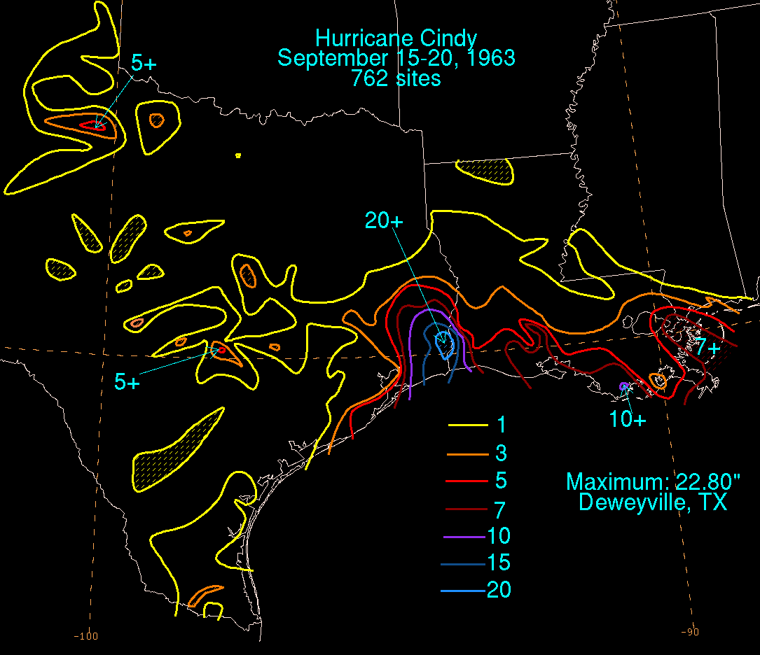
s of Hurricane Cindy produced torrential downpours
along the Louisiana coast. Rainfall of 7-10 inches (177.8–254 mm) was reported across southeastern Louisiana. Inland, rainfall of 1-3 inches (25.4-76.2 mm) was reported. Four weather stations in Cameron, Louisiana
received 2.21-5.5 inches (50.8–127 mm) of rain on September 17 and 2.5-4.1 inches (50.8-101.6 mm) the next day. On the same day, Cameron's local newspaper reported winds gusting to 45 mph (72 km/h) and a tide gauge reported sea levels 5.5 – above normal. In Lake Charles
, a weather station reported 4.07 inches (101.6 mm) of rain over a three day span and winds of 23 mph (37 km/h), gusting to 35 mph (56 km/h). The weather station also reported a pressure reading of 976 mbar (28.8 inHg). In Lafayette, the airport reported rainfall of 1.2 inches (25.4 mm) on September 17. In addition, the airport reported winds of 28 mph (45 km/h) and a barometric pressure of 1014 mbar (29.9 inHg).
The heavy rainfall caused extensive flooding along the Louisiana coastline as floodwaters covered two highways leading away from the coastline and caused Calcasieu River to overflow its banks. Elsewhere in Louisiana, there was moderate damage to roads and crops. Offshore, an oil worker drowned after falling off a lifeboat while evacuating personnel from two oil rigs.
, the eye of Hurricane Cindy made landfall between the towns of Galveston
and Port Arthur
, with the eye passing over High Island
at 0000 UTC (7 a.m. CDT). Offshore, sustained winds were clocked at 80 mph (135 km/h) while a weather station in Galveston reported sustained winds of 54 mph (87 km/h) with gusts up to 74 mph (119 km/h). A tide gauge in Galveston reported water levels 4.6 feet (1.4 m) above normal. Damage in Galveston-Sabine Pass area was limited to pier
s and small boats. In addition, strong winds caused moderate roof damage in Gilchrist
and Winnie
. As the storm moved inland, it produced heavy rainfall across central, interior portions of south Texas and the Rio Grande Valley
. In Deweyville
, the storm dropped rainfall that totaled up to 23 inches (584.2 mm) over a three day period. Storm totals ranging 20.15-23.50 inches (508-584.2 mm) were reported in other counties in Texas. The heavy rainfall caused severe flooding in much of the inland counties in Texas. In Jefferson County
, a levee
protecting a suburb of Port Arthur broke on the morning of September 18 but was under control hours later. Volunteer workers packed over 50,000 sandbags to reinforce the levee to preventing it from breaking further. Another canal however overflowed its banks causing moderate flooding that covered Highway 365 and inundated a few homes. In Beaumont
, floodwaters inundated 2,000 homes. Overall, damage in Jefferson County amounted to $9.18 million (1963 USD; $ USD). The flooding also killed two people.
In Orange County
, floodwaters forced the evacuation of 500 residents and inundated houses in waters up to 18 inches (457.2 mm). Damage in Orange County amounted to $2 million (1963 USD; $ USD). Newton County
sustained only $125,000 (1963 USD; $ USD) in flood damage because, most of the rainwater ran off into the Sabine River. Hardin County also reported $125,000 (1963 USD; $ USD). In Chambers County, houses on the coast between High Island and Port Bolivar
sustained minimal damage, totaling to only $25,000 (1963 USD; $ USD). Elsewhere in that county, at least $5,000 (1963 USD; $ USD) in damage was done to the High Island fishing pier, and agricultural losses reached $275,000 (1963 USD; $ USD). In Galveston County
property damage was similar, reaching $25,000 (1963 USD; $ USD). Several boats sustained extensive damage, including one sail boat that crashed into another vessel, and a 33 feet (10.1 m) pleasure cruiser that capsized in shallow water.
received moderate to heavy rainfall from the outer bands of Cindy. The highest rainfall total in Oklahoma was at Saddle Mountain where a rain gauge reported rainfall of 5.65 inches (500 mm) over a four day period although that report was incomplete. The town of Carnegie
also reported rainfall of 5 inches (127 mm). Elsewhere in Oklahoma, rainfall between 1-3 inches (25.4-76.2 mm), much of it concentrated in the central and southwestern portion of the state. The heavy rainfall caused moderate flooding which forced an evacuation of 300 people and damaged 90 homes and businesses. A damage figure in Oklahoma was unknown.
In Arkansas
, the effects from Cindy was minimal and limited to light rainfall, the highest rainfall from Cindy was 0.55 inches (13.9 mm) near El Dorado, Arkansas
. Elsewhere, the storm dropped 0.04-0.40 inches (1.01 mm-10.1 mm) of rain. There was no reported damage from Cindy's impact on Arkansas
.
Cindy dropped rainfall as far east as the border of Mississippi and Alabama
. Much of it was light rainfall, with many areas of Mississippi reporting 1 to 3 in (25.4 to 76.2 mm) of precipitation. However, in the extreme southwestern portion of the state, heavier rainfall was reported, and peaked between 7 and 10 in (177.8 and 254 mm) in Hancock County
.
declared much of eastern and central Texas a disaster area
on September 24, 1963. The declaration allowed state and local governments to receive federal aid.
Saffir-Simpson Hurricane Scale
The Saffir–Simpson Hurricane Scale , or the Saffir–Simpson Hurricane Wind Scale , classifies hurricanes — Western Hemisphere tropical cyclones that exceed the intensities of tropical depressions and tropical storms — into five categories distinguished by the intensities of their sustained winds...
hurricane that struck southeastern Texas
Texas
Texas is the second largest U.S. state by both area and population, and the largest state by area in the contiguous United States.The name, based on the Caddo word "Tejas" meaning "friends" or "allies", was applied by the Spanish to the Caddo themselves and to the region of their settlement in...
in September 1963. It was the fourth tropical cyclone
Tropical cyclone
A tropical cyclone is a storm system characterized by a large low-pressure center and numerous thunderstorms that produce strong winds and heavy rain. Tropical cyclones strengthen when water evaporated from the ocean is released as the saturated air rises, resulting in condensation of water vapor...
, third named storm, and third hurricane of the 1963 Atlantic hurricane season
1963 Atlantic hurricane season
The 1963 Atlantic hurricane season was a below average Atlantic hurricane season, with nine named storms. Although the season officially began on June 1, the first storm did not form until nearly a month later. Hurricane Cindy made landfall in Texas before dissipating in the southern portion of the...
, Cindy formed on September 16 from a trough of low pressure in the northwestern Gulf of Mexico
Gulf of Mexico
The Gulf of Mexico is a partially landlocked ocean basin largely surrounded by the North American continent and the island of Cuba. It is bounded on the northeast, north and northwest by the Gulf Coast of the United States, on the southwest and south by Mexico, and on the southeast by Cuba. In...
. After becoming a tropical cyclone, Cindy moved north-northwestward and rapidly intensified into a hurricane on September 17. Later that day, Cindy made landfall near High Island, Texas
High Island, Texas
High Island is an unincorporated area located in the Bolivar Peninsula census-designated place, Galveston County, Texas, United States. The community is located in the extreme eastern part of the county on Bolivar Peninsula, less than one mile from Chambers County and less than two miles from...
as a minimal hurricane. Cindy then turned southwestward and quickly weakened into a tropical storm on September. Cindy continued to deteriorate inland, and diminishing to tropical depression six hours after weakening to a tropical storm. By September 20, Cindy dissipated over southern Texas.
It was the first storm of the 1963 season to make landfall along the United States
United States
The United States of America is a federal constitutional republic comprising fifty states and a federal district...
coastline and the first hurricane to form in the Gulf of Mexico since 1960. Cindy brought heavy rainfall across eastern Texas and western Louisiana
Louisiana
Louisiana is a state located in the southern region of the United States of America. Its capital is Baton Rouge and largest city is New Orleans. Louisiana is the only state in the U.S. with political subdivisions termed parishes, which are local governments equivalent to counties...
. The storm also affected Arkansas
Arkansas
Arkansas is a state located in the southern region of the United States. Its name is an Algonquian name of the Quapaw Indians. Arkansas shares borders with six states , and its eastern border is largely defined by the Mississippi River...
, Mississippi
Mississippi
Mississippi is a U.S. state located in the Southern United States. Jackson is the state capital and largest city. The name of the state derives from the Mississippi River, which flows along its western boundary, whose name comes from the Ojibwe word misi-ziibi...
, and Oklahoma
Oklahoma
Oklahoma is a state located in the South Central region of the United States of America. With an estimated 3,751,351 residents as of the 2010 census and a land area of 68,667 square miles , Oklahoma is the 28th most populous and 20th-largest state...
. The effects of Cindy left $12.5 million (1963 USD
United States dollar
The United States dollar , also referred to as the American dollar, is the official currency of the United States of America. It is divided into 100 smaller units called cents or pennies....
; $ USD) and three fatalities.
Meteorological history
Cindy formed on September 16, from a troughTrough (meteorology)
A trough is an elongated region of relatively low atmospheric pressure, often associated with fronts.Unlike fronts, there is not a universal symbol for a trough on a weather chart. The weather charts in some countries or regions mark troughs by a line. In the United States, a trough may be marked...
of low pressure 200 miles (322 km) east-northeast of Brownsville, Texas
Brownsville, Texas
Brownsville is a city in the southernmost tip of the state of Texas, in the United States. It is located on the northern bank of the Rio Grande, directly north and across the border from Matamoros, Tamaulipas, Mexico. Brownsville is the 16th largest city in the state of Texas with a population of...
. Shortly thereafter, a ship reported tropical storm force winds, prompting forecasters at the National Hurricane Center
National Hurricane Center
The National Hurricane Center , located at Florida International University in Miami, Florida, is the division of the National Weather Service responsible for tracking and predicting weather systems within the tropics between the Prime Meridian and the 140th meridian west poleward to the 30th...
to name the storm Cindy. The storm tracked north-northwest near 8 mph (12.9 km/h), and continued at near that speed and direction for almost 24 hours. By 1800 UTC an eye
Eye (cyclone)
The eye is a region of mostly calm weather found at the center of strong tropical cyclones. The eye of a storm is a roughly circular area and typically 30–65 km in diameter. It is surrounded by the eyewall, a ring of towering thunderstorms where the second most severe weather of a cyclone...
was detected on radar
Radar
Radar is an object-detection system which uses radio waves to determine the range, altitude, direction, or speed of objects. It can be used to detect aircraft, ships, spacecraft, guided missiles, motor vehicles, weather formations, and terrain. The radar dish or antenna transmits pulses of radio...
as the storm was located 200 miles (322 km) east of Corpus Christi
Corpus Christi, Texas
Corpus Christi is a coastal city in the South Texas region of the U.S. state of Texas. The county seat of Nueces County, it also extends into Aransas, Kleberg, and San Patricio counties. The MSA population in 2008 was 416,376. The population was 305,215 at the 2010 census making it the...
. Early on September 17, Cindy intensified enough to be upgraded to hurricane status. This was based on the ship SS Sabine reporting hurricane force winds near the center of circulation. Simultaneously, Cindy attained its peak intensity with maximum sustained winds of 80 mph (130 km/h) and a minimum barometric pressure of 996 mbar (29.4 inHg).
Intensity leveled-off slightly after Cindy attained peak intensity, with winds dropping to minimal hurricane status. Later on September 17, Cindy made landfall near Port Arthur, Texas
Port Arthur, Texas
-Demographics:As of the 2000 census, there were 57,755 people, 21,839 households, and 14,675 families residing in the city. The population density was 696.5 people per square mile . There were 24,713 housing units at an average density of 298.0 per square mile...
with winds of 75 mph (120 km/h). After landfall, the storm stalled out over eastern Texas for 18 hours before drifting slowly westward. The southwestward drift caused Cindy to rapidly weaken to a weak tropical storm on September 18 and later to a tropical depression a day later. After drifting slowly for two days over southeastern Texas, Cindy finally dissipated on September 20 northwest of Brownsville
Brownsville, Texas
Brownsville is a city in the southernmost tip of the state of Texas, in the United States. It is located on the northern bank of the Rio Grande, directly north and across the border from Matamoros, Tamaulipas, Mexico. Brownsville is the 16th largest city in the state of Texas with a population of...
.
Preparations
The U.S. Weather Bureau office in New Orleans issued gale warningsTropical cyclone warnings and watches
Warnings and watches are two levels of alert issued by national weather forecasting bodies to coastal areas threatened by the imminent approach of a tropical cyclone of tropical storm or hurricane intensity. They are notices to the local population and civil authorities to make appropriate...
and a hurricane watch from Freeport, Texas
Freeport, Texas
Freeport is a city in Brazoria County, Texas within the Houston–Sugar Land–Baytown metropolitan area and is situated in Southeast Texas. As of the 2000 U.S...
to Grand Isle, Louisiana
Grand Isle, Louisiana
Grand Isle is a town in Jefferson Parish, Louisiana, located on a barrier island of the same name in the Gulf of Mexico. The island is at the mouth of Barataria Bay where it meets the gulf. As of the 2000 census, the town population was 1,541; during summers, the population sometimes increases to...
in its second advisory. In its next advisory, the tropical storm warnings were changed to hurricane warnings as Cindy reached hurricane status. The warnings were extended to include Galveston, Texas and Vermillion Bay, Louisiana and small boats were told to remain in port while shipping traffic in the path of Hurricane Cindy were warned of the deteriorating conditions. Inland, the Weather Bureau stated in their advisory that flood warnings would be issued since the storm was forecast to bring heavy rain to eastern Texas and western Louisiana. In Lake Charles, Louisiana
Lake Charles, Louisiana
Lake Charles is the fifth-largest incorporated city in the U.S. state of Louisiana, located on Lake Charles, Prien Lake, and the Calcasieu River. Located in Calcasieu Parish, a major cultural, industrial, and educational center in the southwest region of the state, and one of the most important in...
, forecasters advised residents to take preparations and evacuate in anticipation that Cindy would cause flooding in low-lying areas. Another Weather Bureau center in Corpus Christi, Texas, stated in its advisory that Cindy was no threat to the city as the center of the storm was moving northeastward. However, the Bureau warned residents about the threat of high surf along the southeastern Texas coast. A weather station in Galveston issued gale warnings and meteorologists predicted that the storm would bring high tides and squalls five feet above normal to the city. The Galveston weather center also advised residents to go to storm shelters until the rough seas subsided.
Forecasters at the Weather Bureau forecast center in Port Arthur, Texas, predicted that Cindy would bring tides four feet above normal and advised residents in Port Arthur to take precautionary measures. In its 0000 UTC (7:00 p.m. CST) advisory on September 17, forecasters expected the flooding from Hurricane Cindy to be limited to coastal sections of Port Arthur and not significantly affect inland areas stretching from the Intercoastal Channel Bridge to the Sabine Pass Highway. In addition, forecasters predicted that the storm would bring severe thunderstorms and tornado
Tornado
A tornado is a violent, dangerous, rotating column of air that is in contact with both the surface of the earth and a cumulonimbus cloud or, in rare cases, the base of a cumulus cloud. They are often referred to as a twister or a cyclone, although the word cyclone is used in meteorology in a wider...
es and thus prompted a tornado watch in a 60 mile (97 km) radius, stretching from College Station, Texas
College Station, Texas
College Station is a city in Brazos County, Texas, situated in East Central Texas in the heart of the Brazos Valley. The city is located within the most populated region of Texas, near three of the 10 largest cities in the United States - Houston, Dallas, and San Antonio...
to Lafayette, Louisiana
Lafayette, Louisiana
Lafayette is a city in and the parish seat of Lafayette Parish, Louisiana, United States, on the Vermilion River. The population was 120,623 at the 2010 census...
.
Overall, 9,600 residents in Louisiana and eastern Texas were evacuated in response to the warnings. Offshore, many oil rigs were evacuated.
Impact
Saffir-Simpson Hurricane Scale
The Saffir–Simpson Hurricane Scale , or the Saffir–Simpson Hurricane Wind Scale , classifies hurricanes — Western Hemisphere tropical cyclones that exceed the intensities of tropical depressions and tropical storms — into five categories distinguished by the intensities of their sustained winds...
hurricane, Cindy left $12.5 million (1963; $ USD) most of it from flooding and three fatalities from drowning incidents.
Louisiana
The outer rainbandRainband
A rainband is a cloud and precipitation structure associated with an area of rainfall which is significantly elongated. Rainbands can be stratiform or convective, and are generated by differences in temperature. When noted on weather radar imagery, this precipitation elongation is referred to as...
s of Hurricane Cindy produced torrential downpours
Rain
Rain is liquid precipitation, as opposed to non-liquid kinds of precipitation such as snow, hail and sleet. Rain requires the presence of a thick layer of the atmosphere to have temperatures above the melting point of water near and above the Earth's surface...
along the Louisiana coast. Rainfall of 7-10 inches (177.8–254 mm) was reported across southeastern Louisiana. Inland, rainfall of 1-3 inches (25.4-76.2 mm) was reported. Four weather stations in Cameron, Louisiana
Cameron, Louisiana
Cameron is a census-designated place in and the parish seat of Cameron Parish, Louisiana, United States. The population was 1,965 at the 2000 census. It is part of the Lake Charles Metropolitan Statistical Area...
received 2.21-5.5 inches (50.8–127 mm) of rain on September 17 and 2.5-4.1 inches (50.8-101.6 mm) the next day. On the same day, Cameron's local newspaper reported winds gusting to 45 mph (72 km/h) and a tide gauge reported sea levels 5.5 – above normal. In Lake Charles
Lake Charles, Louisiana
Lake Charles is the fifth-largest incorporated city in the U.S. state of Louisiana, located on Lake Charles, Prien Lake, and the Calcasieu River. Located in Calcasieu Parish, a major cultural, industrial, and educational center in the southwest region of the state, and one of the most important in...
, a weather station reported 4.07 inches (101.6 mm) of rain over a three day span and winds of 23 mph (37 km/h), gusting to 35 mph (56 km/h). The weather station also reported a pressure reading of 976 mbar (28.8 inHg). In Lafayette, the airport reported rainfall of 1.2 inches (25.4 mm) on September 17. In addition, the airport reported winds of 28 mph (45 km/h) and a barometric pressure of 1014 mbar (29.9 inHg).
The heavy rainfall caused extensive flooding along the Louisiana coastline as floodwaters covered two highways leading away from the coastline and caused Calcasieu River to overflow its banks. Elsewhere in Louisiana, there was moderate damage to roads and crops. Offshore, an oil worker drowned after falling off a lifeboat while evacuating personnel from two oil rigs.
Texas
In TexasTexas
Texas is the second largest U.S. state by both area and population, and the largest state by area in the contiguous United States.The name, based on the Caddo word "Tejas" meaning "friends" or "allies", was applied by the Spanish to the Caddo themselves and to the region of their settlement in...
, the eye of Hurricane Cindy made landfall between the towns of Galveston
Galveston, Texas
Galveston is a coastal city located on Galveston Island in the U.S. state of Texas. , the city had a total population of 47,743 within an area of...
and Port Arthur
Port Arthur, Texas
-Demographics:As of the 2000 census, there were 57,755 people, 21,839 households, and 14,675 families residing in the city. The population density was 696.5 people per square mile . There were 24,713 housing units at an average density of 298.0 per square mile...
, with the eye passing over High Island
High Island, Texas
High Island is an unincorporated area located in the Bolivar Peninsula census-designated place, Galveston County, Texas, United States. The community is located in the extreme eastern part of the county on Bolivar Peninsula, less than one mile from Chambers County and less than two miles from...
at 0000 UTC (7 a.m. CDT). Offshore, sustained winds were clocked at 80 mph (135 km/h) while a weather station in Galveston reported sustained winds of 54 mph (87 km/h) with gusts up to 74 mph (119 km/h). A tide gauge in Galveston reported water levels 4.6 feet (1.4 m) above normal. Damage in Galveston-Sabine Pass area was limited to pier
Pier
A pier is a raised structure, including bridge and building supports and walkways, over water, typically supported by widely spread piles or pillars...
s and small boats. In addition, strong winds caused moderate roof damage in Gilchrist
Gilchrist
Gilchrist is a surname of Scottish origin, having originated in Islay. According to several genealogy websites, it literally means "servant of Christ." Some variations known to exist are Gillecrist, Gilcreest, Gilcrest, Gilchrest and Gilcress.Gilchrist may refer to:* Adam Gilchrist, Australian...
and Winnie
Winnie, Texas
Winnie is a census-designated place in Chambers County, Texas, United States. The population was 2,914 at the 2000 census.-Geography:Winnie is located at . According to the United States Census Bureau, the CDP has a total area of , all of it land.-Historical development:The town plat was filed in...
. As the storm moved inland, it produced heavy rainfall across central, interior portions of south Texas and the Rio Grande Valley
Rio Grande Valley
The Rio Grande Valley or the Lower Rio Grande Valley, informally called The Valley, is an area located in the southernmost tip of South Texas...
. In Deweyville
Deweyville, Texas
Deweyville is a census-designated place in Newton County, Texas, United States. The population was 1,190 at the 2000 census.-Geography:Deweyville is located at ....
, the storm dropped rainfall that totaled up to 23 inches (584.2 mm) over a three day period. Storm totals ranging 20.15-23.50 inches (508-584.2 mm) were reported in other counties in Texas. The heavy rainfall caused severe flooding in much of the inland counties in Texas. In Jefferson County
Jefferson County, Texas
Jefferson County is a county located in the state of Texas, United States. As of 2000, the population was 252,051. Its county seat is Beaumont, and it is named for the former U.S...
, a levee
Levee
A levee, levée, dike , embankment, floodbank or stopbank is an elongated naturally occurring ridge or artificially constructed fill or wall, which regulates water levels...
protecting a suburb of Port Arthur broke on the morning of September 18 but was under control hours later. Volunteer workers packed over 50,000 sandbags to reinforce the levee to preventing it from breaking further. Another canal however overflowed its banks causing moderate flooding that covered Highway 365 and inundated a few homes. In Beaumont
Beaumont, Texas
Beaumont is a city in and county seat of Jefferson County, Texas, United States, within the Beaumont–Port Arthur Metropolitan Statistical Area. The city's population was 118,296 at the 2010 census. With Port Arthur and Orange, it forms the Golden Triangle, a major industrial area on the...
, floodwaters inundated 2,000 homes. Overall, damage in Jefferson County amounted to $9.18 million (1963 USD; $ USD). The flooding also killed two people.
In Orange County
Orange County, Texas
Orange County is one of 254 counties of the State of Texas and its county seat is the city of Orange, Texas. In the year 2000, the population of Orange County was about 85,000. Orange County is the county in the very southeastern corner of Texas, with a boundary with Louisiana and a seacoast on the...
, floodwaters forced the evacuation of 500 residents and inundated houses in waters up to 18 inches (457.2 mm). Damage in Orange County amounted to $2 million (1963 USD; $ USD). Newton County
Newton County, Texas
Newton County is the easternmost county in the U.S. state of Texas. In of 2000, its population was 15,072. Its county seat is Newton. Newton county is named for John Newton, a veteran of the American Revolutionary War...
sustained only $125,000 (1963 USD; $ USD) in flood damage because, most of the rainwater ran off into the Sabine River. Hardin County also reported $125,000 (1963 USD; $ USD). In Chambers County, houses on the coast between High Island and Port Bolivar
Port Bolivar, Texas
Port Bolivar is an unincorporated area located in the Bolivar Peninsula census-designated place, in Galveston County, Texas, United States state of Texas within Galveston County and part of the metropolitan area., Port Bolivar had a population of 1,200...
sustained minimal damage, totaling to only $25,000 (1963 USD; $ USD). Elsewhere in that county, at least $5,000 (1963 USD; $ USD) in damage was done to the High Island fishing pier, and agricultural losses reached $275,000 (1963 USD; $ USD). In Galveston County
Galveston County, Texas
Galveston County is a county located in the U.S. state of Texas within the Houston–Sugar Land–Baytown metropolitan area. As of the 2010 U.S. Census, the population was 291,309. Its county seat is Galveston. League City is the largest city in Galveston County in terms of population; between...
property damage was similar, reaching $25,000 (1963 USD; $ USD). Several boats sustained extensive damage, including one sail boat that crashed into another vessel, and a 33 feet (10.1 m) pleasure cruiser that capsized in shallow water.
Elsewhere
OklahomaOklahoma
Oklahoma is a state located in the South Central region of the United States of America. With an estimated 3,751,351 residents as of the 2010 census and a land area of 68,667 square miles , Oklahoma is the 28th most populous and 20th-largest state...
received moderate to heavy rainfall from the outer bands of Cindy. The highest rainfall total in Oklahoma was at Saddle Mountain where a rain gauge reported rainfall of 5.65 inches (500 mm) over a four day period although that report was incomplete. The town of Carnegie
Carnegie, Oklahoma
Carnegie is a town in Caddo County, Oklahoma, United States. The population was 1,723 at the 2010 census.-Geography:Carnegie is located at .According to the United States Census Bureau, the town has a total area of , all of it land....
also reported rainfall of 5 inches (127 mm). Elsewhere in Oklahoma, rainfall between 1-3 inches (25.4-76.2 mm), much of it concentrated in the central and southwestern portion of the state. The heavy rainfall caused moderate flooding which forced an evacuation of 300 people and damaged 90 homes and businesses. A damage figure in Oklahoma was unknown.
In Arkansas
Arkansas
Arkansas is a state located in the southern region of the United States. Its name is an Algonquian name of the Quapaw Indians. Arkansas shares borders with six states , and its eastern border is largely defined by the Mississippi River...
, the effects from Cindy was minimal and limited to light rainfall, the highest rainfall from Cindy was 0.55 inches (13.9 mm) near El Dorado, Arkansas
El Dorado, Arkansas
El Dorado , a multi-cultural arts center: South Arkansas Arts Center , an award-winning renovated downtown, and numerous sporting, shopping, and dining opportunities. El Dorado is the population, cultural, and business center of the 7,300 mi² regional area...
. Elsewhere, the storm dropped 0.04-0.40 inches (1.01 mm-10.1 mm) of rain. There was no reported damage from Cindy's impact on Arkansas
Arkansas
Arkansas is a state located in the southern region of the United States. Its name is an Algonquian name of the Quapaw Indians. Arkansas shares borders with six states , and its eastern border is largely defined by the Mississippi River...
.
Cindy dropped rainfall as far east as the border of Mississippi and Alabama
Alabama
Alabama is a state located in the southeastern region of the United States. It is bordered by Tennessee to the north, Georgia to the east, Florida and the Gulf of Mexico to the south, and Mississippi to the west. Alabama ranks 30th in total land area and ranks second in the size of its inland...
. Much of it was light rainfall, with many areas of Mississippi reporting 1 to 3 in (25.4 to 76.2 mm) of precipitation. However, in the extreme southwestern portion of the state, heavier rainfall was reported, and peaked between 7 and 10 in (177.8 and 254 mm) in Hancock County
Hancock County, Mississippi
-Demographics:As of the census of 2000, there were 42,967 people, 16,897 households, and 11,827 families residing in the county. The population density was 90 people per square mile . There were 21,072 housing units at an average density of 44 per square mile...
.
Aftermath
President John F. KennedyJohn F. Kennedy
John Fitzgerald "Jack" Kennedy , often referred to by his initials JFK, was the 35th President of the United States, serving from 1961 until his assassination in 1963....
declared much of eastern and central Texas a disaster area
Disaster area
A disaster area is a region or a locale heavily damaged by either natural hazards, such as tornadoes, hurricanes, tsunamis, floods, earthquakes, technological hazards including nuclear and radiation accidents, or sociological hazards like riots, terrorism or war. The population living there often...
on September 24, 1963. The declaration allowed state and local governments to receive federal aid.
See also
- List of Atlantic hurricanes
- List of wettest tropical cyclones in the United States