
Hurricane Ivan
Encyclopedia
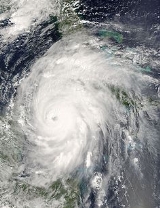
Hurricane Ivan was a large, long-lived, Cape Verde-type hurricane
that caused widespread damage in the Caribbean
and United States
. The cyclone
was the ninth named storm, the sixth hurricane and the fourth major hurricane of the active 2004 Atlantic hurricane season
. Ivan formed in early September and had reached Category 5
strength on the Saffir-Simpson Hurricane Scale
and became the 10th most intense Atlantic hurricane ever recorded. At its peak in the Gulf of Mexico
, Ivan was the size of the state of Texas
. It also spawned 119 tornadoes across the eastern United States.
Ivan caused catastrophic damage to Grenada
as a strong Category 3
storm, heavy damage to Jamaica
as a strong Category 4
storm and and then Grand Cayman
, Cayman Islands
and the western tip of Cuba
as a Category 5
storm. After peaking in strength, the hurricane moved north-northwest across the Gulf of Mexico to strike Gulf Shores, Alabama
as a strong Category 3
storm, causing significant damage. Ivan dropped heavy rains on the Southeastern United States
as it progressed northeast and east through the eastern United States, becoming an extratropical cyclone
. The remnant low from the storm moved into the western subtropical Atlantic and regenerated into a tropical cyclone, which then moved across Florida
and the Gulf of Mexico into Louisiana
and Texas
, causing minimal damage. Ivan caused an estimated US$
18 billion (2004 USD, $ USD) in damages to the United States, making it the fifth costliest hurricane ever to strike the country.
 On September 2, 2004, Tropical Depression Nine formed from a large tropical wave
southwest of Cape Verde
. As the system moved to the west, it strengthened gradually, becoming Tropical Storm Ivan on September 3 and reaching hurricane strength on September 5, 1,150 miles (1,850 km) to the east of Tobago
. Later that day, the storm intensified rapidly, and by 5 p.m. EDT
(2100 UTC), Ivan became a Category 3
hurricane with winds of 125 miles per hour (201.2 km/h). The National Hurricane Center
said that the rapid strengthening of Ivan on September 5 was unprecedented at such a low latitude
in the Atlantic basin
.
As it moved west, Ivan weakened slightly because of wind shear
in the area. The storm passed over Grenada
on September 7, battering several of the Windward Islands
. As it entered the Caribbean Sea
, Ivan reintensified rapidly and became a Category 5 hurricane just north of the Windward Netherlands Antilles
(Curaçao
and Bonaire) and Aruba
on September 9 with winds reaching 160 mph (260 km/h). Ivan weakened slightly as it moved west-northwest towards Jamaica
. As Ivan approached the island late on September 10, it began a westward jog that kept the eye and the strongest winds to the south and west. However, because of its proximity to the Jamaican coast, the island was battered with hurricane-force winds for hours.
After passing Jamaica, Ivan resumed a more northerly track and regained Category 5 strength. Ivan's strength continued to fluctuate as it moved west on September 11, and the storm attained its highest winds of 165 mph (270 km/h) as it passed within 30 miles (48.3 km) of Grand Cayman
. Ivan reached its peak strength with a minimum central pressure of 910 mb on September 12, making Ivan the tenth most intense Atlantic hurricane on record, as of August 2007. Ivan passed through the Yucatán Channel
late on September 13 while its eyewall affected the westernmost tip of Cuba
. Once over the Gulf of Mexico
, it weakened slightly to Category 4 strength, which it maintained while approaching the Gulf Coast of the United States
.
 Just before it made landfall in the United States, Ivan's eyewall weakened considerably, and its southwestern portion almost disappeared. Around 2 a.m. CDT September 16 (0700 UTC), Ivan made landfall on the U.S. mainland in Gulf Shores, Alabama
as a Category 3 hurricane with 120 mph (190 km/h) winds; some hurricane information sources put the winds from Hurricane Ivan near 130 mph (210 km/h) upon landfall in Alabama and northwestern Florida. Ivan then continued inland, maintaining hurricane strength until it was over central Alabama
. Ivan weakened rapidly that evening and became a tropical depression the same day, still over Alabama. Ivan lost tropical characteristics on September 18 while crossing Virginia
. Later that day, the remnant low drifted off the U.S. mid-Atlantic
coast into the Atlantic Ocean, and the low pressure disturbance continued to dump rain on the United States.
On September 20, Ivan's remnant surface low completed an anticyclonic
loop and moved across the Florida peninsula. As it continued west across the northern Gulf of Mexico, the system reorganized and again took on tropical characteristics. On September 22 the National Weather Service, "after considerable and sometimes animated in-house discussion [regarding] the demise of Ivan," determined that the low was in fact a result of the remnants of Ivan and thus named it accordingly. On the evening of September 23, the revived Ivan made landfall near Cameron, Louisiana
as a tropical depression. Ivan finally dissipated on September 24 as it moved overland into Texas
.
 Ivan set several new records for intensity at low latitudes. When Ivan first became a Category 3
hurricane on September 3 (1800 UTC), it was centered near 10.2 degrees north from the equator. This is the most southerly location on record for a major hurricane in the Atlantic basin. Just six hours later, Ivan also became the most southerly Category 4 hurricane on record in the Atlantic basin when it reached that intensity while located at 10.6 degrees north. Finally, at midnight (UTC) on September 9 while centered at 13.7 degrees north, Ivan became the most southerly Category 5 hurricane on record in the Atlantic basin.
Ivan had the world record of 33 (32 consecutive) six-hour periods with an intensity at or above Category 4 strength. This record was broken two years later by Pacific Hurricane/Typhoon Ioke
, which had 36 (33 consecutive) six-hour periods at Category 4 strength. This contributed to Ivan's total Accumulated Cyclone Energy
(ACE) of 70.38.
Scientists from the Naval Research Laboratory at Stennis Space Center, Mississippi
have used a computer model to predict that, at the height of the storm, the maximum wave height within Ivan's eyewall reached 131 feet (40 m).
. Early on the following day, a tropical storm watch was issued for Grenada. Later that day, hurricane watch were also put into effect for St. Lucia, and Martinique
. A tropical storm warning was issued for St. Vincent and Grenadines and Tobago
and Grenada. By 1500 UTC on September 6, the hurricane watches and tropical storm watches and warnings were upgraded to a hurricane warning and expanded to: Barbados, St. Vincent and Grenadines, St. Lucia, Tobago, Grenada. Simultaneously, a tropical storm warning was issued for Trinidad
. On September 7, the hurricane warning in effect for several countries was downgraded to a tropical storm warning. By September 8, all tropical storm and hurricane watches and warnings were discontinued in the eastern portions of the Windward Islands
.
As Ivan continued westward, a hurricane watch was issued for the ABC islands on September 8. Many schools and businesses were closed in the Netherlands Antilles
, and about 300 people evacuated their homes on Curaçao
.
In the Caribbean, 500,000 Jamaica
ns were told to evacuate from coastal areas, but only 5,000 were reported to have moved to shelters. 12,000 residents and tourists were evacuated from Isla Mujeres
off the Yucatán Peninsula
.
, mandatory evacuations of vulnerable areas in Jefferson
, Lafourche
, Plaquemines
, St. Charles
, St. James, St. John the Baptist
, and Tangipahoa
parishes took place, with voluntary evacuations ordered in six other parishes. More than one-third of the population of Greater New Orleans evacuated voluntarily, including more than half of the residents of New Orleans
itself. At the height of the evacuation, intense traffic congestion on local highways caused delays of up to 12 hours. About a thousand special-needs patients were housed at the Louisiana Superdome
during the storm. Ivan was considered a particular threat to the New Orleans area because dangers of catastrophic flooding. However, Plaquemines and St. Bernard Parishes suffered a moderate amount of wind damage. Hurricane preparedness for New Orleans
was judged poor. At one point, the media sparked fears of an "Atlantean
" catastrophe if the hurricane were to make a direct strike on the city. These fears were not realized, as the storm's path turned further east.
In Mississippi
, evacuation of mobile home
s and vulnerable areas took place in Hancock
, Jackson
, and Harrison
counties. In Alabama
, evacuation in the areas of Mobile
and Baldwin
counties south of Interstate 10
was ordered, including a third of the incorporated territory of the City of Mobile, as well as several of its suburbs. In Florida, a full evacuation of the Florida Keys
began at 7:00 a.m. EDT September 10 but was lifted at 5:00 a.m. EDT September 13 as Ivan tracked further west than originally predicted. Voluntary evacuations were declared in ten counties along the Florida Panhandle
, with strong emphasis in the immediate western counties of Escambia
, Santa Rosa
, and Okaloosa
. Ivan prompted the evacuation of 270 animals at "The Little Zoo That Could" in Alabama. The evacuation had to be completed within a couple of hours, with only 28 volunteers available to move the animals.
Ivan killed 64 people in the Caribbean—mainly in Grenada
and Jamaica
—three in Venezuela
, and 25 in the United States, including fourteen in Florida
. Thirty-two more deaths in the United States were indirectly attributed to Ivan. Tornadoes spawned by Ivan struck communities along concentric arcs on the leading edge of the storm. In Florida, Blountstown
, Marianna
, and Panama City Beach
suffered three of the most devastating tornadoes. A Firefighter with Good Springs Volunteer Fire Department (G.S.V.F.D.) located in Anderson, AL was also killed during the storm. Firefighter Romine was working with the members of his fire department and others to remove fallen trees from roadways in the wake of Hurricane Ivan. He went to a merchant to purchase a replacement chain for his personal saw. As he drove back to the fire station, a portion of a storm-damaged tree fell onto his personal vehicle. The fallen tree was approximately 2 1/2 feet in diameter and fell directly on the cab of his. He was killed instantly. A passenger in the truck received non-life-threatening injuries. A Panama City Beach news station was nearly hit by an F2
tornado during the storm. Ivan also caused over US$
13 billion (2004 USD, $ USD)in damages in the United States and US$3 billion in the Caribbean (2004 USD, $ USD).
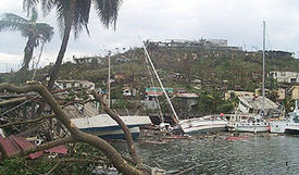
Ivan passed directly over Grenada
on September 7, 2004, killing 39 people. The capital, St. George's
, was severely damaged and several notable buildings were destroyed, including the residence of the prime minister. Ivan also caused extensive damage to a local prison, allowing most of the inmates to escape. The island, in the words of a Caribbean disaster official, suffered "total devastation." According to a member of the Grenadian parliament, at least 85% of the small island was devastated. Extensive looting was reported. In all, damage on the island totalled US$
815 million (2004 USD, $ USD).
Elsewhere in the Caribbean, a pregnant woman was killed in Tobago
when a tree fell on top of her home, and a 75-year-old Canadian woman drowned in Barbados
. Three deaths were reported in Venezuela
. Over five hundred homes on Barbados and around 60 homes in St. Vincent and the Grenadines were either damage or destroyed.
, causing significant wind and flood damage. Overall, 17 people were killed in Jamaica and 18,000 people were left homeless as a result of the flood waters and high winds. Most of the major resorts and hotels fared well, though, and were reopened only a few days after Ivan had passed. Damage on Jamaica totaled US$
360 million (2004 USD, $ USD).
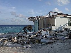 In the Cayman Islands
, Governor Bruce Dinwiddy
described damage as "very, very severe and widespread." Despite strict building codes which made the islands' buildings well able to withstand even major hurricanes, Ivan's winds and storm surge were so strong that a quarter or more of the buildings on the islands were reported to be uninhabitable, with 85% damaged to some extent. Much of Grand Cayman
still remained without power, water, or sewer services for several months later. After five months, barely half the pre-Ivan hotel rooms were usable. Only two people were killed on the islands, though at first many deaths were suspected because of the many graves that were washed up during the storm. The damage totaled US$
1.85 billion (2004 USD, $ USD) in the Cayman Islands.
. The region's Caribbean Development Bank
estimates Ivan caused over US$
3 billion (2004 USD, $ USD) damage on island nations, mostly in the Cayman Islands
, Grenada
, and Jamaica
. Minor damage, including some beach erosion, was reported in the ABC islands.
Even though Ivan did not make landfall on Cuba
n soil, its storm surge caused localized flooding on Santiago de Cuba
and Granma
, on the southern part of the island. At Cienfuegos
, the storm produced waves of 15 feet (4.6 m), and Pinar del Río
recorded 13.3 inches (337.8 mm) of rainfall. While there were no casualties on the island, the Cuban government estimates that about US$1.2 billion (2004 USD, $ USD) of property damage were directly due to Ivan.
 Along with the 14 deaths in Florida
, Ivan is blamed for eight deaths in North Carolina
, two in Georgia
, and one in Mississippi
. An additional 32 deaths were reported as indirectly caused by the storm.
Ivan caused an estimated US$
13 billion (2004 USD, $ USD) in damage in the United States alone, making it the third costliest hurricane on record at the time, just behind Hurricane Charley's
US$14 billion (2004 USD, $ USD), and above Hurricane Hugo
. It has since fallen to sixth place.
, Pensacola Beach, dwellings situated far inland, as much as 20 miles (32 km) from the Gulf coast, along the shorelines of Escambia Bay
, East Bay
, Blackwater Bay, and Ward Basin in Escambia County
and Santa Rosa County, and Fort Walton Beach, Florida
on the eastern side of the storm. The area just west of Pensacola, including the community of Warrington
(which includes Pensacola NAS
), Perdido Key, and Innerarity Point, took the brunt of the storm. Some of the subdivisions in this part of the county were completely destroyed, with a few key roads in the Perdido area only opened in late 2005, over a year after the storm hit. Shattered windows from gusts and flying projectiles experienced throughout the night of the storm were common. As of December 2007, roads remained closed on Pensacola Beach because of damage from Ivan's storm surge.
In Pensacola, the Interstate 10
bridge across Escambia Bay
was heavily damaged, with as much as a quarter-mile (400 m) of the bridge collapsing into the bay. The causeway that carries U.S. Highway 90 across the northern part of the same bay was also heavily damaged. Virtually all of Perdido Key, an area on the outskirts of Pensacola that bore the brunt of Ivan's winds and rain, was essentially leveled. High surf and wind brought extensive damage to Innerarity Point.
On September 26, 2006, over two years after Ivan struck the region, funding for the last 501 FEMA-provided trailers
ran out for those living in Santa Rosa and Escambia counties.
 The city of Demopolis, over 100 miles (160.9 km) inland in west-central Alabama
, endured wind gusts estimated at 90 mph (144.8 km/h), while Montgomery
saw wind gusts in the 60 mph (96.6 km/h) to 70 mph (112.7 km/h) range at the height of the storm.
The heaviest damage as Ivan made landfall on the U.S. coastline was observed in Baldwin County
in Alabama, where the storm's eye (and eyewall) made landfall. High surf and wind brought extensive damage to Orange Beach
near the border with Florida. There, two five-story condominium buildings were undermined to the point of collapse by Ivan's storm surge of 14 feet (4.3 m). Both were made of steel-reinforced concrete. Debris gathered in piles along the storm tide, exacerbating the damage when the floodwaters crashed into homes sitting on pilings. Brewton
, a community about 50 miles (80.5 km) inland, also suffered severe damage.
In addition to the damage to the southern portions of the state, there was extensive damage to the state's electrical grid. At the height of the outages, Alabama Power reported 489,000 subscribers had lost electrical power—roughly half of its subscriber base.
near Atlanta and many other river
s and stream
s to levels at or near 100-year records. The Delaware River
and its tributaries crested just below their all-time records set by Hurricane Diane
in 1955. Locations in southern New Hampshire
and Massachusetts
received over 7 inches of rainfall from the remnants of Ivan, causing flooding and mudslides.
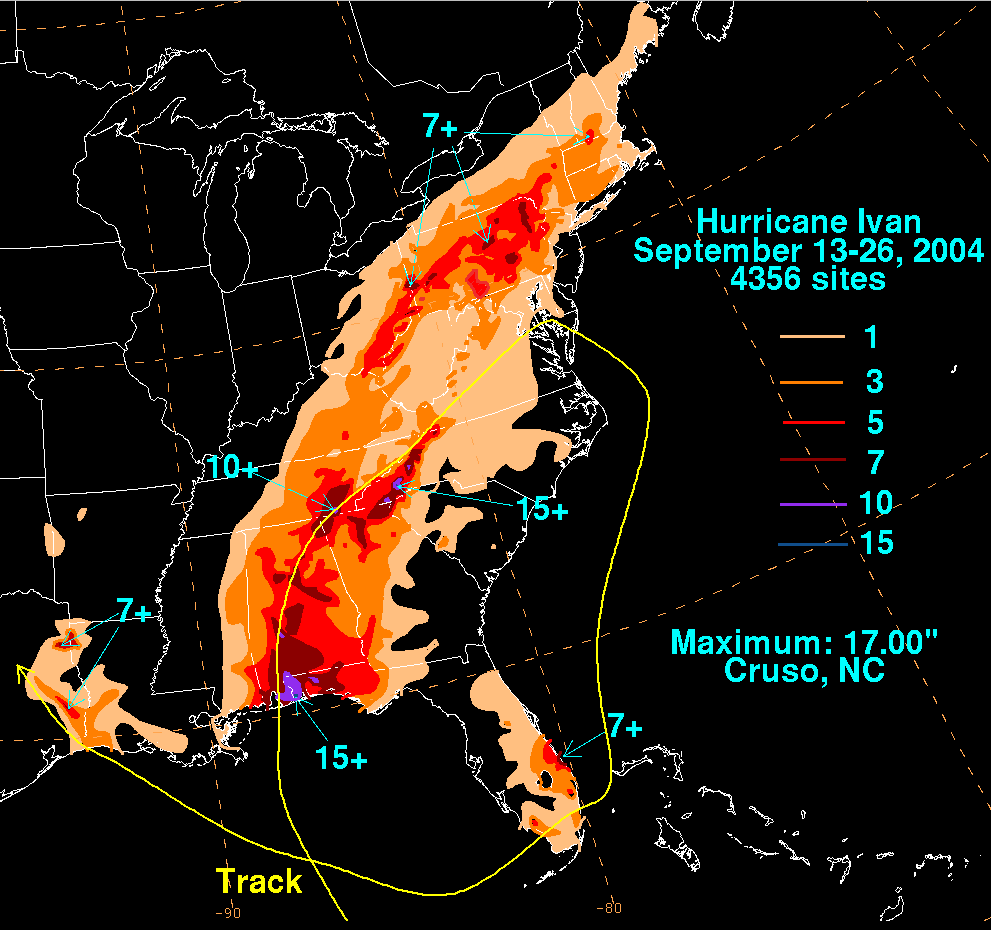
In western North Carolina
, many streams and rivers reached well above flood stage in an area that was heavily flood damaged just a week and a half prior from the remnants of Hurricane Frances
, causing many roads to be closed. High winds contributed to widespread power outages throughout the mountainous region. The Blue Ridge Parkway
as well as Interstate 40
through the Pigeon River gorge in Haywood County, North Carolina
sustained major damage, and landslides were common across the mountains. There was major flooding along the French Broad River
and Swannanoa River
in Asheville, North Carolina
and along the Pigeon River near Canton, North Carolina
. As a result of the rain, a major debris flow of mud, rocks, trees, and water surged down Peek's Creek
, near Franklin, North Carolina
, sweeping away 15 houses and killing five people.
The system also spawned deadly tornado
es as far north as Maryland
and destroyed seven oil platforms in the Gulf of Mexico
while at sea. While crossing over the Mid-Atlantic states, Ivan's remnants spawned 117 tornadoes across the eastern United States, with the 40 tornadoes spawned in Virginia
on September 17 setting a daily record for the commonwealth. Ivan then moved into the Wheeling, West Virginia
and Pittsburgh
area, causing major flooding and gusty winds. Pittsburgh International Airport
recorded the highest 24-hour rainfall for Pittsburgh, recording 5.95 inches (151.1 mm) of rain. Ivan's rain caused widespread flooding. The Juniata River
basin was flooded, and the Frankstown Branch crested at its highest level ever. After Ivan regenerated in the Gulf of Mexico, it caused further heavy rainfall up to 8 inches (203.2 mm) in areas of Louisiana
and Texas
.
, Prince Edward Island
, and eastern Nova Scotia
. The system produced intense waves of up to 50 feet (15.2 m) near Cape Bonavista
. The system killed two when it grounded a fishing vessel and was indirectly responsible for four traffic fatalities in Newfoundland.
suffered serious economic repercussions following the destruction caused by Ivan. Before Ivan, the economy of Grenada was projected to grow by 4.7%, but the island's economy instead contracted by nearly 3% in 2004. The economy was also projected to grow by at least 5% through 2007, but, , that estimate had been lowered to less than 1%. The government of Grenada also admitted that government debt
, 130% of the island's GDP
, was "unsustainable" in October 2004 and appointed a group of professional debt advisors in January 2005 to help seek a cooperative restructuring agreement with creditors.
More than US$
150 million was sent to Grenada in 2004 to aid reconstruction following Ivan, but the economic situation remains fragile. The International Monetary Fund
reports that as "difficult enough as the present fiscal situation is, it is unfortunately quite easy to envisage circumstances that would make it even more so." Furthermore, "shortfalls in donor financing and tax revenues, or events such as a further rise in global oil prices, pose a grave risk."
completed thirty small projects in rural communities and low income neighborhoods. 66 health clinics, 25 schools, and 62 water and sanitation systems were repair during the first phase of recovery. About 1,379 farmers, herders and micro businesses became eligible for grants. By 2005, 55 schools and colleges were repaired, while restoration of 1,560 houses had occurred.
George W. Bush
submitted a budget to the United States Congress
which requested over $7 billion (2004 USD) in aid to victims of Hurricane Ivan and Jeanne
in the following states: Alabama, Florida, Georgia, Louisiana, Mississippi, North Carolina, Ohio
, Pennsylvania
, and West Virginia. Over half of the $7 billion (2004 USD) was to cover uninsured damage to property and public infrastructure. $889 million was spent to repair Department of Defense facilities. About $600 million was earmarked for emergency repairs to highways and road damaged by Hurricanes Charley, Frances, Ivan, and Jeanne. The Small Business Administration
(SBA) used $472 million to provide loans for small businesses and homeowners affected by the storm. Approximately $400 million was given by the United States Department of Agriculture
to provide financial assistance agricultural producers suffering crop and other losses. Around $132 million (2004 USD) was used to repair Federal facilities by several government agencies, including: United States Coast Guard
, Federal Bureau of Prisons
, the United States Forest Service
, and the Federal Aviation Administration
. The United States Army Corps of Engineers
used $81 million (2004 USD) for restoration of coastal areas affected by Ivan. In addition, $50 million (2004 USD) of which was for disaster and famine assistance funds Grenada, Jamaica, and Haiti.
Following the storm in Alabama, more than 167,700 people applied for assistance in 65 counties in the state. over 51 counties in the state became eligible for public assistance. As a result, the U.S. Department of Homeland Security's
Federal Emergency Management Agency
(FEMA) and the Alabama Emergency Management Agency (AEMA) received $735 million (2004 USD), which was spent in disaster assistance, and included: low-interest loans for homeowners and businesses, disaster food stamps, Disaster Unemployment Assistance to though left unemployed as a result of Ivan, "Project Rebound", and to fill the 5,856 National Flood Insurance Program claims. In addition, there were repairs to public infrastructure such as roads, bridges, buildings, utilities, facilities, and parks. 20 Disaster Recovery Centers were opened in 13 counties, which also included the Poarch Creek Indian Reservation
. Overall, FEMA paid 90% of the $735 million (2004 USD), while the AEMA paid for the other 10%.
Ivan is suspected of bringing spores of soybean rust
from Venezuela
into the United States, the first ever occurrences of soybean rust found in North America. Since the Florida soybean crop had already been mostly harvested, economic damage was limited. Some of the most severe outbreaks in South America have been known to reduce soybean
crop yields by half or more. Following the storm, more than 138,500 residents in 15 counties of the Florida Panhandle applied for federal and state aid. In those counties, a total of $162.6 million was approved by FEMA’s Individuals and Households Program. In addition, residents of 24 other countries in Florida were eligible for grants and loans. By September 2005, more than $1.4 billion (2004 USD) in federal and state assistant was approved for residents and communities in Florida Panhandle. In addition, the National Flood Insurance Program pay nearly $869 million (2004 USD) for more than 9,800 insurance claims after Ivan.
More than $4 million (2004 USD) in disaster assistance was approved for Mississippi by FEMA and Mississippi Emergency Management Agency (MEMA). In addition, the SBA issued nearly 3,000 applications for low-interest loans to homeowners, renters, landlords, businesses, and non-profit organizations. The loans covered up to $200,000 in real estate repairs/replacements and up to $40,000 in repairs/replacements of personal property.
Residents and business owners in eight parishes of Louisiana became eligible for disaster assistance. By one week before the deadline to apply on November 15, 2004, about 9,527 residents applied for disaster assistance. Overall, FEMA and the Government of Louisiana provided more than $3.8 million (2004 USD) to those that requested assistance. In addition, the SBA also allowed applications for loans to repair personal property until that day.
and will never again be used in the Atlantic basin
. It was replaced by Igor, which was retired after its use in the 2010 season.
Cape Verde-type hurricane
A Cape Verde-type hurricane is an Atlantic hurricane that develops near the Cape Verde islands, off the west coast of Africa. The average hurricane season has about two Cape Verde-type hurricanes, which are usually the largest and most intense storms of the season because they often have plenty of...
that caused widespread damage in the Caribbean
Caribbean Sea
The Caribbean Sea is a sea of the Atlantic Ocean located in the tropics of the Western hemisphere. It is bounded by Mexico and Central America to the west and southwest, to the north by the Greater Antilles, and to the east by the Lesser Antilles....
and United States
United States
The United States of America is a federal constitutional republic comprising fifty states and a federal district...
. The cyclone
Cyclone
In meteorology, a cyclone is an area of closed, circular fluid motion rotating in the same direction as the Earth. This is usually characterized by inward spiraling winds that rotate anticlockwise in the Northern Hemisphere and clockwise in the Southern Hemisphere of the Earth. Most large-scale...
was the ninth named storm, the sixth hurricane and the fourth major hurricane of the active 2004 Atlantic hurricane season
2004 Atlantic hurricane season
The 2004 Atlantic hurricane season officially began on June 1, 2004, and lasted until November 30, 2004. These dates conventionally delimit the period of each year when most tropical cyclones form in the Atlantic basin...
. Ivan formed in early September and had reached Category 5
Saffir-Simpson Hurricane Scale
The Saffir–Simpson Hurricane Scale , or the Saffir–Simpson Hurricane Wind Scale , classifies hurricanes — Western Hemisphere tropical cyclones that exceed the intensities of tropical depressions and tropical storms — into five categories distinguished by the intensities of their sustained winds...
strength on the Saffir-Simpson Hurricane Scale
Saffir-Simpson Hurricane Scale
The Saffir–Simpson Hurricane Scale , or the Saffir–Simpson Hurricane Wind Scale , classifies hurricanes — Western Hemisphere tropical cyclones that exceed the intensities of tropical depressions and tropical storms — into five categories distinguished by the intensities of their sustained winds...
and became the 10th most intense Atlantic hurricane ever recorded. At its peak in the Gulf of Mexico
Gulf of Mexico
The Gulf of Mexico is a partially landlocked ocean basin largely surrounded by the North American continent and the island of Cuba. It is bounded on the northeast, north and northwest by the Gulf Coast of the United States, on the southwest and south by Mexico, and on the southeast by Cuba. In...
, Ivan was the size of the state of Texas
Texas
Texas is the second largest U.S. state by both area and population, and the largest state by area in the contiguous United States.The name, based on the Caddo word "Tejas" meaning "friends" or "allies", was applied by the Spanish to the Caddo themselves and to the region of their settlement in...
. It also spawned 119 tornadoes across the eastern United States.
Ivan caused catastrophic damage to Grenada
Grenada
Grenada is an island country and Commonwealth Realm consisting of the island of Grenada and six smaller islands at the southern end of the Grenadines in the southeastern Caribbean Sea...
as a strong Category 3
Saffir-Simpson Hurricane Scale
The Saffir–Simpson Hurricane Scale , or the Saffir–Simpson Hurricane Wind Scale , classifies hurricanes — Western Hemisphere tropical cyclones that exceed the intensities of tropical depressions and tropical storms — into five categories distinguished by the intensities of their sustained winds...
storm, heavy damage to Jamaica
Jamaica
Jamaica is an island nation of the Greater Antilles, in length, up to in width and 10,990 square kilometres in area. It is situated in the Caribbean Sea, about south of Cuba, and west of Hispaniola, the island harbouring the nation-states Haiti and the Dominican Republic...
as a strong Category 4
Saffir-Simpson Hurricane Scale
The Saffir–Simpson Hurricane Scale , or the Saffir–Simpson Hurricane Wind Scale , classifies hurricanes — Western Hemisphere tropical cyclones that exceed the intensities of tropical depressions and tropical storms — into five categories distinguished by the intensities of their sustained winds...
storm and and then Grand Cayman
Grand Cayman
Grand Cayman is the largest of the three Cayman Islands and the location of the nation's capital, George Town. In relation to the other two Cayman Islands, it is approximately 75 miles southwest of Little Cayman and 90 miles southwest of Cayman Brac.-Geography:Grand Cayman encompasses 76% of...
, Cayman Islands
Cayman Islands
The Cayman Islands is a British Overseas Territory and overseas territory of the European Union located in the western Caribbean Sea. The territory comprises the three islands of Grand Cayman, Cayman Brac, and Little Cayman, located south of Cuba and northwest of Jamaica...
and the western tip of Cuba
Cuba
The Republic of Cuba is an island nation in the Caribbean. The nation of Cuba consists of the main island of Cuba, the Isla de la Juventud, and several archipelagos. Havana is the largest city in Cuba and the country's capital. Santiago de Cuba is the second largest city...
as a Category 5
Saffir-Simpson Hurricane Scale
The Saffir–Simpson Hurricane Scale , or the Saffir–Simpson Hurricane Wind Scale , classifies hurricanes — Western Hemisphere tropical cyclones that exceed the intensities of tropical depressions and tropical storms — into five categories distinguished by the intensities of their sustained winds...
storm. After peaking in strength, the hurricane moved north-northwest across the Gulf of Mexico to strike Gulf Shores, Alabama
Gulf Shores, Alabama
-External links:*...
as a strong Category 3
Saffir-Simpson Hurricane Scale
The Saffir–Simpson Hurricane Scale , or the Saffir–Simpson Hurricane Wind Scale , classifies hurricanes — Western Hemisphere tropical cyclones that exceed the intensities of tropical depressions and tropical storms — into five categories distinguished by the intensities of their sustained winds...
storm, causing significant damage. Ivan dropped heavy rains on the Southeastern United States
Southeastern United States
The Southeastern United States, colloquially referred to as the Southeast, is the eastern portion of the Southern United States. It is one of the most populous regions in the United States of America....
as it progressed northeast and east through the eastern United States, becoming an extratropical cyclone
Extratropical cyclone
Extratropical cyclones, sometimes called mid-latitude cyclones or wave cyclones, are a group of cyclones defined as synoptic scale low pressure weather systems that occur in the middle latitudes of the Earth having neither tropical nor polar characteristics, and are connected with fronts and...
. The remnant low from the storm moved into the western subtropical Atlantic and regenerated into a tropical cyclone, which then moved across Florida
Florida
Florida is a state in the southeastern United States, located on the nation's Atlantic and Gulf coasts. It is bordered to the west by the Gulf of Mexico, to the north by Alabama and Georgia and to the east by the Atlantic Ocean. With a population of 18,801,310 as measured by the 2010 census, it...
and the Gulf of Mexico into Louisiana
Louisiana
Louisiana is a state located in the southern region of the United States of America. Its capital is Baton Rouge and largest city is New Orleans. Louisiana is the only state in the U.S. with political subdivisions termed parishes, which are local governments equivalent to counties...
and Texas
Texas
Texas is the second largest U.S. state by both area and population, and the largest state by area in the contiguous United States.The name, based on the Caddo word "Tejas" meaning "friends" or "allies", was applied by the Spanish to the Caddo themselves and to the region of their settlement in...
, causing minimal damage. Ivan caused an estimated US$
United States dollar
The United States dollar , also referred to as the American dollar, is the official currency of the United States of America. It is divided into 100 smaller units called cents or pennies....
18 billion (2004 USD, $ USD) in damages to the United States, making it the fifth costliest hurricane ever to strike the country.
Meteorological history
Tropical wave
Tropical waves, easterly waves, or tropical easterly waves, also known as African easterly waves in the Atlantic region, are a type of atmospheric trough, an elongated area of relatively low air pressure, oriented north to south, which move from east to west across the tropics causing areas of...
southwest of Cape Verde
Cape Verde
The Republic of Cape Verde is an island country, spanning an archipelago of 10 islands located in the central Atlantic Ocean, 570 kilometres off the coast of Western Africa...
. As the system moved to the west, it strengthened gradually, becoming Tropical Storm Ivan on September 3 and reaching hurricane strength on September 5, 1,150 miles (1,850 km) to the east of Tobago
Tobago
Tobago is the smaller of the two main islands that make up the Republic of Trinidad and Tobago. It is located in the southern Caribbean, northeast of the island of Trinidad and southeast of Grenada. The island lies outside the hurricane belt...
. Later that day, the storm intensified rapidly, and by 5 p.m. EDT
North American Eastern Time Zone
The Eastern Time Zone of the United States and Canada is a time zone that falls mostly along the east coast of North America. Its UTC time offset is −5 hrs during standard time and −4 hrs during daylight saving time...
(2100 UTC), Ivan became a Category 3
Saffir-Simpson Hurricane Scale
The Saffir–Simpson Hurricane Scale , or the Saffir–Simpson Hurricane Wind Scale , classifies hurricanes — Western Hemisphere tropical cyclones that exceed the intensities of tropical depressions and tropical storms — into five categories distinguished by the intensities of their sustained winds...
hurricane with winds of 125 miles per hour (201.2 km/h). The National Hurricane Center
National Hurricane Center
The National Hurricane Center , located at Florida International University in Miami, Florida, is the division of the National Weather Service responsible for tracking and predicting weather systems within the tropics between the Prime Meridian and the 140th meridian west poleward to the 30th...
said that the rapid strengthening of Ivan on September 5 was unprecedented at such a low latitude
Latitude
In geography, the latitude of a location on the Earth is the angular distance of that location south or north of the Equator. The latitude is an angle, and is usually measured in degrees . The equator has a latitude of 0°, the North pole has a latitude of 90° north , and the South pole has a...
in the Atlantic basin
Atlantic Basin
The Atlantic Basin is the Atlantic Ocean.Atlantic Basin may also refer to:* Atlantic Basin Iron Works, an ironworks that operated in Brooklyn, New York, in the early to mid-20th century...
.
As it moved west, Ivan weakened slightly because of wind shear
Wind shear
Wind shear, sometimes referred to as windshear or wind gradient, is a difference in wind speed and direction over a relatively short distance in the atmosphere...
in the area. The storm passed over Grenada
Grenada
Grenada is an island country and Commonwealth Realm consisting of the island of Grenada and six smaller islands at the southern end of the Grenadines in the southeastern Caribbean Sea...
on September 7, battering several of the Windward Islands
Windward Islands
The Windward Islands are the southern islands of the Lesser Antilles, within the West Indies.-Name and geography:The Windward Islands are called such because they were more windward to sailing ships arriving in the New World than the Leeward Islands, given that the prevailing trade winds in the...
. As it entered the Caribbean Sea
Caribbean Sea
The Caribbean Sea is a sea of the Atlantic Ocean located in the tropics of the Western hemisphere. It is bounded by Mexico and Central America to the west and southwest, to the north by the Greater Antilles, and to the east by the Lesser Antilles....
, Ivan reintensified rapidly and became a Category 5 hurricane just north of the Windward Netherlands Antilles
Netherlands Antilles
The Netherlands Antilles , also referred to informally as the Dutch Antilles, was an autonomous Caribbean country within the Kingdom of the Netherlands, consisting of two groups of islands in the Lesser Antilles: Aruba, Bonaire and Curaçao , in Leeward Antilles just off the Venezuelan coast; and Sint...
(Curaçao
Curaçao
Curaçao is an island in the southern Caribbean Sea, off the Venezuelan coast. The Country of Curaçao , which includes the main island plus the small, uninhabited island of Klein Curaçao , is a constituent country of the Kingdom of the Netherlands...
and Bonaire) and Aruba
Aruba
Aruba is a 33 km-long island of the Lesser Antilles in the southern Caribbean Sea, located 27 km north of the coast of Venezuela and 130 km east of Guajira Peninsula...
on September 9 with winds reaching 160 mph (260 km/h). Ivan weakened slightly as it moved west-northwest towards Jamaica
Jamaica
Jamaica is an island nation of the Greater Antilles, in length, up to in width and 10,990 square kilometres in area. It is situated in the Caribbean Sea, about south of Cuba, and west of Hispaniola, the island harbouring the nation-states Haiti and the Dominican Republic...
. As Ivan approached the island late on September 10, it began a westward jog that kept the eye and the strongest winds to the south and west. However, because of its proximity to the Jamaican coast, the island was battered with hurricane-force winds for hours.
After passing Jamaica, Ivan resumed a more northerly track and regained Category 5 strength. Ivan's strength continued to fluctuate as it moved west on September 11, and the storm attained its highest winds of 165 mph (270 km/h) as it passed within 30 miles (48.3 km) of Grand Cayman
Grand Cayman
Grand Cayman is the largest of the three Cayman Islands and the location of the nation's capital, George Town. In relation to the other two Cayman Islands, it is approximately 75 miles southwest of Little Cayman and 90 miles southwest of Cayman Brac.-Geography:Grand Cayman encompasses 76% of...
. Ivan reached its peak strength with a minimum central pressure of 910 mb on September 12, making Ivan the tenth most intense Atlantic hurricane on record, as of August 2007. Ivan passed through the Yucatán Channel
Yucatán Channel
The Yucatán Channel is a strait between Mexico and Cuba. It connects the Yucatán Basin of the Caribbean Sea with the Gulf of Mexico. The strait is across between Cape Catoche in Mexico and Cape San Antonio, Cuba and reaches a maximum depth of .-References:...
late on September 13 while its eyewall affected the westernmost tip of Cuba
Cuba
The Republic of Cuba is an island nation in the Caribbean. The nation of Cuba consists of the main island of Cuba, the Isla de la Juventud, and several archipelagos. Havana is the largest city in Cuba and the country's capital. Santiago de Cuba is the second largest city...
. Once over the Gulf of Mexico
Gulf of Mexico
The Gulf of Mexico is a partially landlocked ocean basin largely surrounded by the North American continent and the island of Cuba. It is bounded on the northeast, north and northwest by the Gulf Coast of the United States, on the southwest and south by Mexico, and on the southeast by Cuba. In...
, it weakened slightly to Category 4 strength, which it maintained while approaching the Gulf Coast of the United States
Gulf Coast of the United States
The Gulf Coast of the United States, sometimes referred to as the Gulf South, South Coast, or 3rd Coast, comprises the coasts of American states that are on the Gulf of Mexico, which includes Texas, Louisiana, Mississippi, Alabama, and Florida and are known as the Gulf States...
.
Gulf Shores, Alabama
-External links:*...
as a Category 3 hurricane with 120 mph (190 km/h) winds; some hurricane information sources put the winds from Hurricane Ivan near 130 mph (210 km/h) upon landfall in Alabama and northwestern Florida. Ivan then continued inland, maintaining hurricane strength until it was over central Alabama
Alabama
Alabama is a state located in the southeastern region of the United States. It is bordered by Tennessee to the north, Georgia to the east, Florida and the Gulf of Mexico to the south, and Mississippi to the west. Alabama ranks 30th in total land area and ranks second in the size of its inland...
. Ivan weakened rapidly that evening and became a tropical depression the same day, still over Alabama. Ivan lost tropical characteristics on September 18 while crossing Virginia
Virginia
The Commonwealth of Virginia , is a U.S. state on the Atlantic Coast of the Southern United States. Virginia is nicknamed the "Old Dominion" and sometimes the "Mother of Presidents" after the eight U.S. presidents born there...
. Later that day, the remnant low drifted off the U.S. mid-Atlantic
Mid-Atlantic States
The Mid-Atlantic states, also called middle Atlantic states or simply the mid Atlantic, form a region of the United States generally located between New England and the South...
coast into the Atlantic Ocean, and the low pressure disturbance continued to dump rain on the United States.
On September 20, Ivan's remnant surface low completed an anticyclonic
Anticyclone
An anticyclone is a weather phenomenon defined by the United States' National Weather Service's glossary as "[a] large-scale circulation of winds around a central region of high atmospheric pressure, clockwise in the Northern Hemisphere, counterclockwise in the Southern Hemisphere"...
loop and moved across the Florida peninsula. As it continued west across the northern Gulf of Mexico, the system reorganized and again took on tropical characteristics. On September 22 the National Weather Service, "after considerable and sometimes animated in-house discussion [regarding] the demise of Ivan," determined that the low was in fact a result of the remnants of Ivan and thus named it accordingly. On the evening of September 23, the revived Ivan made landfall near Cameron, Louisiana
Cameron, Louisiana
Cameron is a census-designated place in and the parish seat of Cameron Parish, Louisiana, United States. The population was 1,965 at the 2000 census. It is part of the Lake Charles Metropolitan Statistical Area...
as a tropical depression. Ivan finally dissipated on September 24 as it moved overland into Texas
Texas
Texas is the second largest U.S. state by both area and population, and the largest state by area in the contiguous United States.The name, based on the Caddo word "Tejas" meaning "friends" or "allies", was applied by the Spanish to the Caddo themselves and to the region of their settlement in...
.
Records
Saffir-Simpson Hurricane Scale
The Saffir–Simpson Hurricane Scale , or the Saffir–Simpson Hurricane Wind Scale , classifies hurricanes — Western Hemisphere tropical cyclones that exceed the intensities of tropical depressions and tropical storms — into five categories distinguished by the intensities of their sustained winds...
hurricane on September 3 (1800 UTC), it was centered near 10.2 degrees north from the equator. This is the most southerly location on record for a major hurricane in the Atlantic basin. Just six hours later, Ivan also became the most southerly Category 4 hurricane on record in the Atlantic basin when it reached that intensity while located at 10.6 degrees north. Finally, at midnight (UTC) on September 9 while centered at 13.7 degrees north, Ivan became the most southerly Category 5 hurricane on record in the Atlantic basin.
Ivan had the world record of 33 (32 consecutive) six-hour periods with an intensity at or above Category 4 strength. This record was broken two years later by Pacific Hurricane/Typhoon Ioke
Hurricane Ioke
Hurricane Ioke was the strongest hurricane ever recorded in the Central Pacific...
, which had 36 (33 consecutive) six-hour periods at Category 4 strength. This contributed to Ivan's total Accumulated Cyclone Energy
Accumulated cyclone energy
Accumulated cyclone energy is a measure used by the National Oceanic and Atmospheric Administration to express the activity of individual tropical cyclones and entire tropical cyclone seasons, particularly the North Atlantic hurricane season. It uses an approximation of the energy used by a...
(ACE) of 70.38.
Scientists from the Naval Research Laboratory at Stennis Space Center, Mississippi
Mississippi
Mississippi is a U.S. state located in the Southern United States. Jackson is the state capital and largest city. The name of the state derives from the Mississippi River, which flows along its western boundary, whose name comes from the Ojibwe word misi-ziibi...
have used a computer model to predict that, at the height of the storm, the maximum wave height within Ivan's eyewall reached 131 feet (40 m).
Caribbean
By September 5, a hurricane watch was posted for BarbadosBarbados
Barbados is an island country in the Lesser Antilles. It is in length and as much as in width, amounting to . It is situated in the western area of the North Atlantic and 100 kilometres east of the Windward Islands and the Caribbean Sea; therein, it is about east of the islands of Saint...
. Early on the following day, a tropical storm watch was issued for Grenada. Later that day, hurricane watch were also put into effect for St. Lucia, and Martinique
Martinique
Martinique is an island in the eastern Caribbean Sea, with a land area of . Like Guadeloupe, it is an overseas region of France, consisting of a single overseas department. To the northwest lies Dominica, to the south St Lucia, and to the southeast Barbados...
. A tropical storm warning was issued for St. Vincent and Grenadines and Tobago
Tobago
Tobago is the smaller of the two main islands that make up the Republic of Trinidad and Tobago. It is located in the southern Caribbean, northeast of the island of Trinidad and southeast of Grenada. The island lies outside the hurricane belt...
and Grenada. By 1500 UTC on September 6, the hurricane watches and tropical storm watches and warnings were upgraded to a hurricane warning and expanded to: Barbados, St. Vincent and Grenadines, St. Lucia, Tobago, Grenada. Simultaneously, a tropical storm warning was issued for Trinidad
Trinidad
Trinidad is the larger and more populous of the two major islands and numerous landforms which make up the island nation of Trinidad and Tobago. It is the southernmost island in the Caribbean and lies just off the northeastern coast of Venezuela. With an area of it is also the fifth largest in...
. On September 7, the hurricane warning in effect for several countries was downgraded to a tropical storm warning. By September 8, all tropical storm and hurricane watches and warnings were discontinued in the eastern portions of the Windward Islands
Windward Islands
The Windward Islands are the southern islands of the Lesser Antilles, within the West Indies.-Name and geography:The Windward Islands are called such because they were more windward to sailing ships arriving in the New World than the Leeward Islands, given that the prevailing trade winds in the...
.
As Ivan continued westward, a hurricane watch was issued for the ABC islands on September 8. Many schools and businesses were closed in the Netherlands Antilles
Netherlands Antilles
The Netherlands Antilles , also referred to informally as the Dutch Antilles, was an autonomous Caribbean country within the Kingdom of the Netherlands, consisting of two groups of islands in the Lesser Antilles: Aruba, Bonaire and Curaçao , in Leeward Antilles just off the Venezuelan coast; and Sint...
, and about 300 people evacuated their homes on Curaçao
Curaçao
Curaçao is an island in the southern Caribbean Sea, off the Venezuelan coast. The Country of Curaçao , which includes the main island plus the small, uninhabited island of Klein Curaçao , is a constituent country of the Kingdom of the Netherlands...
.
In the Caribbean, 500,000 Jamaica
Jamaica
Jamaica is an island nation of the Greater Antilles, in length, up to in width and 10,990 square kilometres in area. It is situated in the Caribbean Sea, about south of Cuba, and west of Hispaniola, the island harbouring the nation-states Haiti and the Dominican Republic...
ns were told to evacuate from coastal areas, but only 5,000 were reported to have moved to shelters. 12,000 residents and tourists were evacuated from Isla Mujeres
Isla Mujeres
Isla Mujeres is one of the ten municipalities of the Mexican state of Quintana Roo. The municipality, located in the northeastern corner of the state is mostly on the mainland and has a municipal seat of the same name; Isla Mujeres...
off the Yucatán Peninsula
Yucatán Peninsula
The Yucatán Peninsula, in southeastern Mexico, separates the Caribbean Sea from the Gulf of Mexico, with the northern coastline on the Yucatán Channel...
.
United States
In LouisianaLouisiana
Louisiana is a state located in the southern region of the United States of America. Its capital is Baton Rouge and largest city is New Orleans. Louisiana is the only state in the U.S. with political subdivisions termed parishes, which are local governments equivalent to counties...
, mandatory evacuations of vulnerable areas in Jefferson
Jefferson Parish, Louisiana
Jefferson Parish is a parish in Louisiana, United States that includes most of the suburbs of New Orleans. The seat of parish government is Gretna....
, Lafourche
Lafourche Parish, Louisiana
Lafourche Parish is a parish located in the south of the U.S. state of Louisiana. It was originally the northern part of Lafourche Interior Parish, which consisted of the present parishes of Lafourche and Terrebonne. The parish seat is Thibodaux...
, Plaquemines
Plaquemines Parish, Louisiana
Plaquemines Parish is the parish with the most combined land and water area in the U.S. state of Louisiana. The parish seat is Pointe à la Hache...
, St. Charles
St. Charles Parish, Louisiana
St. Charles Parish is a parish located in the U.S. state of Louisiana. The parish seat is Hahnville. In 2010, its population was 52,780. In the eighteenth and nineteenth century, this was part of the German Coast, an area along the Mississippi River settled by numerous German pioneers in the...
, St. James, St. John the Baptist
St. John the Baptist Parish, Louisiana
St. John the Baptist Parish is a parish located in the U.S. state of Louisiana.The parish seat is Edgard, an unincorporated area and the unofficial parish captial is LaPlace, an unincorporated area. St. John the Baptist is one of the original 19 parishes in Louisiana. In 2010, its population was...
, and Tangipahoa
Tangipahoa Parish, Louisiana
Tangipahoa Parish is a parish located in the U.S. state of Louisiana, one of the Florida Parishes. The parish seat is Amite City, but the major city is Hammond. As of 2006, the population was 113,137...
parishes took place, with voluntary evacuations ordered in six other parishes. More than one-third of the population of Greater New Orleans evacuated voluntarily, including more than half of the residents of New Orleans
New Orleans, Louisiana
New Orleans is a major United States port and the largest city and metropolitan area in the state of Louisiana. The New Orleans metropolitan area has a population of 1,235,650 as of 2009, the 46th largest in the USA. The New Orleans – Metairie – Bogalusa combined statistical area has a population...
itself. At the height of the evacuation, intense traffic congestion on local highways caused delays of up to 12 hours. About a thousand special-needs patients were housed at the Louisiana Superdome
Louisiana Superdome
The Mercedes-Benz Superdome, previously known as the Louisiana Superdome and colloquially known as the Superdome, is a sports and exhibition arena located in the Central Business District of New Orleans, Louisiana, USA...
during the storm. Ivan was considered a particular threat to the New Orleans area because dangers of catastrophic flooding. However, Plaquemines and St. Bernard Parishes suffered a moderate amount of wind damage. Hurricane preparedness for New Orleans
Hurricane preparedness for New Orleans
Hurricane preparedness in New Orleans has been an issue since the city's early settlement because of the city's location.New Orleans was built on a delta marsh. Unlike the first two centuries of its existence, today, a little less than half of the modern city sits below sea level...
was judged poor. At one point, the media sparked fears of an "Atlantean
Atlantis
Atlantis is a legendary island first mentioned in Plato's dialogues Timaeus and Critias, written about 360 BC....
" catastrophe if the hurricane were to make a direct strike on the city. These fears were not realized, as the storm's path turned further east.
In Mississippi
Mississippi
Mississippi is a U.S. state located in the Southern United States. Jackson is the state capital and largest city. The name of the state derives from the Mississippi River, which flows along its western boundary, whose name comes from the Ojibwe word misi-ziibi...
, evacuation of mobile home
Mobile home
Mobile homes or static caravans are prefabricated homes built in factories, rather than on site, and then taken to the place where they will be occupied...
s and vulnerable areas took place in Hancock
Hancock County, Mississippi
-Demographics:As of the census of 2000, there were 42,967 people, 16,897 households, and 11,827 families residing in the county. The population density was 90 people per square mile . There were 21,072 housing units at an average density of 44 per square mile...
, Jackson
Jackson County, Mississippi
There were 47,676 households out of which 37.00% had children under the age of 18 living with them, 55.70% were married couples living together, 14.50% had a female householder with no husband present, and 25.10% were non-families. 20.80% of all households were made up of individuals and 7.10% had...
, and Harrison
Harrison County, Mississippi
-National protected areas:* De Soto National Forest * Gulf Islands National Seashore - Demographics :As of the census of 2000, there were 189,601 people, 71,538 households, and 48,574 families residing in the county. The population density was 326 people per square mile . There were 79,636 housing...
counties. In Alabama
Alabama
Alabama is a state located in the southeastern region of the United States. It is bordered by Tennessee to the north, Georgia to the east, Florida and the Gulf of Mexico to the south, and Mississippi to the west. Alabama ranks 30th in total land area and ranks second in the size of its inland...
, evacuation in the areas of Mobile
Mobile County, Alabama
Mobile County[p] is a county of the U.S. state of Alabama. Its name is in honor of a tribe of Indians, the Maubila tribe . As of 2011, its population was 415,704. Its county seat is Mobile, Alabama...
and Baldwin
Baldwin County, Alabama
-2010:Whereas according to the 2010 U.S. Census Bureau:*85.7% White*9.4% Black*0.7% Native American*0.7% Asian*0.0% Native Hawaiian or Pacific Islander*1.5% Two or more races*4.4% Hispanic or Latino -2000:...
counties south of Interstate 10
Interstate 10
Interstate 10 is the fourth-longest Interstate Highway in the United States, after I-90, I-80, and I-40. It is the southernmost east–west, coast-to-coast Interstate Highway, although I-4 and I-8 are further south. It stretches from the Pacific Ocean at State Route 1 in Santa Monica,...
was ordered, including a third of the incorporated territory of the City of Mobile, as well as several of its suburbs. In Florida, a full evacuation of the Florida Keys
Florida Keys
The Florida Keys are a coral archipelago in southeast United States. They begin at the southeastern tip of the Florida peninsula, about south of Miami, and extend in a gentle arc south-southwest and then westward to Key West, the westernmost of the inhabited islands, and on to the uninhabited Dry...
began at 7:00 a.m. EDT September 10 but was lifted at 5:00 a.m. EDT September 13 as Ivan tracked further west than originally predicted. Voluntary evacuations were declared in ten counties along the Florida Panhandle
Florida Panhandle
The Florida Panhandle, an informal, unofficial term for the northwestern part of Florida, is a strip of land roughly 200 miles long and 50 to 100 miles wide , lying between Alabama on the north and the west, Georgia also on the north, and the Gulf of Mexico to the south. Its eastern boundary is...
, with strong emphasis in the immediate western counties of Escambia
Escambia County, Florida
Escambia County is the westernmost county in the U.S. state of Florida. The 2010 population was 297,619. The U.S. Census Bureau 2005 estimate for the county is 296,772. Its county seat is Pensacola.- History :...
, Santa Rosa
Santa Rosa County, Florida
Santa Rosa County is a county located in the U.S. state of Florida. According to the 2000 U.S. Census, the population was 117,743, while a July 1, 2005, estimate placed the population at 143,105, an 18% increase making it the 84th fastest growing county in the United States between 2000 and 2005. ...
, and Okaloosa
Okaloosa County, Florida
Okaloosa County is a county located in the state of Florida. Located in northwest Florida, it extends from the Gulf of Mexico to the Alabama state line. As of the 2000 census, the population was 170,498. The U.S. Census Bureau 2005 estimate for the county is 182,172. The 2009 estimate for the...
. Ivan prompted the evacuation of 270 animals at "The Little Zoo That Could" in Alabama. The evacuation had to be completed within a couple of hours, with only 28 volunteers available to move the animals.
Impact
| Country | Total deaths |
Direct deaths |
Damage (2004 USD) |
| Barbados Barbados Barbados is an island country in the Lesser Antilles. It is in length and as much as in width, amounting to . It is situated in the western area of the North Atlantic and 100 kilometres east of the Windward Islands and the Caribbean Sea; therein, it is about east of the islands of Saint... |
1 | 1 | $5 million |
| Cayman Islands Cayman Islands The Cayman Islands is a British Overseas Territory and overseas territory of the European Union located in the western Caribbean Sea. The territory comprises the three islands of Grand Cayman, Cayman Brac, and Little Cayman, located south of Cuba and northwest of Jamaica... |
2 | 1 | $3.5 billion |
| Cuba Cuba The Republic of Cuba is an island nation in the Caribbean. The nation of Cuba consists of the main island of Cuba, the Isla de la Juventud, and several archipelagos. Havana is the largest city in Cuba and the country's capital. Santiago de Cuba is the second largest city... |
0 | 0 | $1.2 billion |
| Dominican Republic Dominican Republic The Dominican Republic is a nation on the island of La Hispaniola, part of the Greater Antilles archipelago in the Caribbean region. The western third of the island is occupied by the nation of Haiti, making Hispaniola one of two Caribbean islands that are shared by two countries... |
4 | 4 | Unknown |
| Grenada Grenada Grenada is an island country and Commonwealth Realm consisting of the island of Grenada and six smaller islands at the southern end of the Grenadines in the southeastern Caribbean Sea... |
39 | 39 | $1.1 billion |
| Jamaica Jamaica Jamaica is an island nation of the Greater Antilles, in length, up to in width and 10,990 square kilometres in area. It is situated in the Caribbean Sea, about south of Cuba, and west of Hispaniola, the island harbouring the nation-states Haiti and the Dominican Republic... |
17 | 17 | $360 million |
| St. Lucia | 0 | 0 | $2.6 million |
| Saint Vincent and the Grenadines Saint Vincent and the Grenadines Saint Vincent and the Grenadines is an island country in the Lesser Antilles chain, namely in the southern portion of the Windward Islands, which lie at the southern end of the eastern border of the Caribbean Sea where the latter meets the Atlantic Ocean.... |
0 | 0 | $40 million |
| Trinidad and Tobago Trinidad and Tobago Trinidad and Tobago officially the Republic of Trinidad and Tobago is an archipelagic state in the southern Caribbean, lying just off the coast of northeastern Venezuela and south of Grenada in the Lesser Antilles... |
1 | 1 | $4.9 million |
| United States | 54 | 25 | $13 billion |
| Venezuela Venezuela Venezuela , officially called the Bolivarian Republic of Venezuela , is a tropical country on the northern coast of South America. It borders Colombia to the west, Guyana to the east, and Brazil to the south... |
3 | 3 | unknown |
| Totals: | 121 | 92 | ~$18.092 billion |
Ivan killed 64 people in the Caribbean—mainly in Grenada
Grenada
Grenada is an island country and Commonwealth Realm consisting of the island of Grenada and six smaller islands at the southern end of the Grenadines in the southeastern Caribbean Sea...
and Jamaica
Jamaica
Jamaica is an island nation of the Greater Antilles, in length, up to in width and 10,990 square kilometres in area. It is situated in the Caribbean Sea, about south of Cuba, and west of Hispaniola, the island harbouring the nation-states Haiti and the Dominican Republic...
—three in Venezuela
Venezuela
Venezuela , officially called the Bolivarian Republic of Venezuela , is a tropical country on the northern coast of South America. It borders Colombia to the west, Guyana to the east, and Brazil to the south...
, and 25 in the United States, including fourteen in Florida
Florida
Florida is a state in the southeastern United States, located on the nation's Atlantic and Gulf coasts. It is bordered to the west by the Gulf of Mexico, to the north by Alabama and Georgia and to the east by the Atlantic Ocean. With a population of 18,801,310 as measured by the 2010 census, it...
. Thirty-two more deaths in the United States were indirectly attributed to Ivan. Tornadoes spawned by Ivan struck communities along concentric arcs on the leading edge of the storm. In Florida, Blountstown
Blountstown, Florida
Blountstown is a city in Calhoun County, Florida, United States. The population was 2,444 at the 2000 census. According to the U.S Census estimates of 2005, the city had a population of 2,433...
, Marianna
Marianna, Florida
Marianna is a city in Jackson County, Florida, United States. The population was 6,230 at the 2000 census. As of 2004, the population estimated by the U.S. Census Bureau is 6,200 . It is the county seat of Jackson County and is home to Chipola College...
, and Panama City Beach
Panama City Beach, Florida
Panama City Beach is a city in Bay County, Florida, United States, on the Gulf of Mexico coast. The city is often referred to under the umbrella term of "Panama City", despite being a distinct municipality from the older and larger inland Panama City to the east, making Panama City and Panama City...
suffered three of the most devastating tornadoes. A Firefighter with Good Springs Volunteer Fire Department (G.S.V.F.D.) located in Anderson, AL was also killed during the storm. Firefighter Romine was working with the members of his fire department and others to remove fallen trees from roadways in the wake of Hurricane Ivan. He went to a merchant to purchase a replacement chain for his personal saw. As he drove back to the fire station, a portion of a storm-damaged tree fell onto his personal vehicle. The fallen tree was approximately 2 1/2 feet in diameter and fell directly on the cab of his. He was killed instantly. A passenger in the truck received non-life-threatening injuries. A Panama City Beach news station was nearly hit by an F2
Fujita scale
The Fujita scale , or Fujita-Pearson scale, is a scale for rating tornado intensity, based primarily on the damage tornadoes inflict on human-built structures and vegetation...
tornado during the storm. Ivan also caused over US$
United States dollar
The United States dollar , also referred to as the American dollar, is the official currency of the United States of America. It is divided into 100 smaller units called cents or pennies....
13 billion (2004 USD, $ USD)in damages in the United States and US$3 billion in the Caribbean (2004 USD, $ USD).
Southeastern Caribbean and Venezuela
Ivan passed directly over Grenada
Grenada
Grenada is an island country and Commonwealth Realm consisting of the island of Grenada and six smaller islands at the southern end of the Grenadines in the southeastern Caribbean Sea...
on September 7, 2004, killing 39 people. The capital, St. George's
St. George's, Grenada
St. George's, population 89,018 , with an agglomeration of 4,500 people , is the capital of Grenada, . The city is surrounded by a hillside of an old volcano crater and is on a horseshoe-shaped harbor....
, was severely damaged and several notable buildings were destroyed, including the residence of the prime minister. Ivan also caused extensive damage to a local prison, allowing most of the inmates to escape. The island, in the words of a Caribbean disaster official, suffered "total devastation." According to a member of the Grenadian parliament, at least 85% of the small island was devastated. Extensive looting was reported. In all, damage on the island totalled US$
United States dollar
The United States dollar , also referred to as the American dollar, is the official currency of the United States of America. It is divided into 100 smaller units called cents or pennies....
815 million (2004 USD, $ USD).
Elsewhere in the Caribbean, a pregnant woman was killed in Tobago
Tobago
Tobago is the smaller of the two main islands that make up the Republic of Trinidad and Tobago. It is located in the southern Caribbean, northeast of the island of Trinidad and southeast of Grenada. The island lies outside the hurricane belt...
when a tree fell on top of her home, and a 75-year-old Canadian woman drowned in Barbados
Barbados
Barbados is an island country in the Lesser Antilles. It is in length and as much as in width, amounting to . It is situated in the western area of the North Atlantic and 100 kilometres east of the Windward Islands and the Caribbean Sea; therein, it is about east of the islands of Saint...
. Three deaths were reported in Venezuela
Venezuela
Venezuela , officially called the Bolivarian Republic of Venezuela , is a tropical country on the northern coast of South America. It borders Colombia to the west, Guyana to the east, and Brazil to the south...
. Over five hundred homes on Barbados and around 60 homes in St. Vincent and the Grenadines were either damage or destroyed.
Jamaica
On September 11 and September 12, the center of Ivan passed near JamaicaJamaica
Jamaica is an island nation of the Greater Antilles, in length, up to in width and 10,990 square kilometres in area. It is situated in the Caribbean Sea, about south of Cuba, and west of Hispaniola, the island harbouring the nation-states Haiti and the Dominican Republic...
, causing significant wind and flood damage. Overall, 17 people were killed in Jamaica and 18,000 people were left homeless as a result of the flood waters and high winds. Most of the major resorts and hotels fared well, though, and were reopened only a few days after Ivan had passed. Damage on Jamaica totaled US$
United States dollar
The United States dollar , also referred to as the American dollar, is the official currency of the United States of America. It is divided into 100 smaller units called cents or pennies....
360 million (2004 USD, $ USD).
Cayman Islands
Cayman Islands
The Cayman Islands is a British Overseas Territory and overseas territory of the European Union located in the western Caribbean Sea. The territory comprises the three islands of Grand Cayman, Cayman Brac, and Little Cayman, located south of Cuba and northwest of Jamaica...
, Governor Bruce Dinwiddy
Bruce Dinwiddy
Bruce Harry Dinwiddy, CMG was the governor of the Cayman Islands from May 2002 to October 2005. He has been working for the Foreign and Commonwealth Office since 1973. Before becoming a colonial administrator, he was posted to many countries around the world, and also spent time working in England...
described damage as "very, very severe and widespread." Despite strict building codes which made the islands' buildings well able to withstand even major hurricanes, Ivan's winds and storm surge were so strong that a quarter or more of the buildings on the islands were reported to be uninhabitable, with 85% damaged to some extent. Much of Grand Cayman
Grand Cayman
Grand Cayman is the largest of the three Cayman Islands and the location of the nation's capital, George Town. In relation to the other two Cayman Islands, it is approximately 75 miles southwest of Little Cayman and 90 miles southwest of Cayman Brac.-Geography:Grand Cayman encompasses 76% of...
still remained without power, water, or sewer services for several months later. After five months, barely half the pre-Ivan hotel rooms were usable. Only two people were killed on the islands, though at first many deaths were suspected because of the many graves that were washed up during the storm. The damage totaled US$
United States dollar
The United States dollar , also referred to as the American dollar, is the official currency of the United States of America. It is divided into 100 smaller units called cents or pennies....
1.85 billion (2004 USD, $ USD) in the Cayman Islands.
Elsewhere in the Caribbean
There were four deaths in the Dominican RepublicDominican Republic
The Dominican Republic is a nation on the island of La Hispaniola, part of the Greater Antilles archipelago in the Caribbean region. The western third of the island is occupied by the nation of Haiti, making Hispaniola one of two Caribbean islands that are shared by two countries...
. The region's Caribbean Development Bank
Caribbean Development Bank
The Caribbean Development Bank is a financial institution which assists Caribbean nations in financing social and economic programs in its member countries...
estimates Ivan caused over US$
United States dollar
The United States dollar , also referred to as the American dollar, is the official currency of the United States of America. It is divided into 100 smaller units called cents or pennies....
3 billion (2004 USD, $ USD) damage on island nations, mostly in the Cayman Islands
Cayman Islands
The Cayman Islands is a British Overseas Territory and overseas territory of the European Union located in the western Caribbean Sea. The territory comprises the three islands of Grand Cayman, Cayman Brac, and Little Cayman, located south of Cuba and northwest of Jamaica...
, Grenada
Grenada
Grenada is an island country and Commonwealth Realm consisting of the island of Grenada and six smaller islands at the southern end of the Grenadines in the southeastern Caribbean Sea...
, and Jamaica
Jamaica
Jamaica is an island nation of the Greater Antilles, in length, up to in width and 10,990 square kilometres in area. It is situated in the Caribbean Sea, about south of Cuba, and west of Hispaniola, the island harbouring the nation-states Haiti and the Dominican Republic...
. Minor damage, including some beach erosion, was reported in the ABC islands.
Even though Ivan did not make landfall on Cuba
Cuba
The Republic of Cuba is an island nation in the Caribbean. The nation of Cuba consists of the main island of Cuba, the Isla de la Juventud, and several archipelagos. Havana is the largest city in Cuba and the country's capital. Santiago de Cuba is the second largest city...
n soil, its storm surge caused localized flooding on Santiago de Cuba
Santiago de Cuba
Santiago de Cuba is the second largest city of Cuba and capital city of Santiago de Cuba Province in the south-eastern area of the island, some south-east of the Cuban capital of Havana....
and Granma
Granma Province
Granma is one of the provinces of Cuba. Its capital is Bayamo. Other towns include Manzanillo and Pilón.-History:...
, on the southern part of the island. At Cienfuegos
Cienfuegos
Cienfuegos is a city on the southern coast of Cuba, capital of Cienfuegos Province. It is located about from Havana, and has a population of 150,000. The city is dubbed La Perla del Sur...
, the storm produced waves of 15 feet (4.6 m), and Pinar del Río
Pinar del Río
Pinar del Río is a city in Cuba. It is the capital of Pinar del Río Province.Inhabitants of the area are called Pinareños.Neighborhoods in the city include La Conchita, La Coloma, Briones Montoto and Las Ovas.-History:...
recorded 13.3 inches (337.8 mm) of rainfall. While there were no casualties on the island, the Cuban government estimates that about US$1.2 billion (2004 USD, $ USD) of property damage were directly due to Ivan.
United States
Florida
Florida is a state in the southeastern United States, located on the nation's Atlantic and Gulf coasts. It is bordered to the west by the Gulf of Mexico, to the north by Alabama and Georgia and to the east by the Atlantic Ocean. With a population of 18,801,310 as measured by the 2010 census, it...
, Ivan is blamed for eight deaths in North Carolina
North Carolina
North Carolina is a state located in the southeastern United States. The state borders South Carolina and Georgia to the south, Tennessee to the west and Virginia to the north. North Carolina contains 100 counties. Its capital is Raleigh, and its largest city is Charlotte...
, two in Georgia
Georgia (U.S. state)
Georgia is a state located in the southeastern United States. It was established in 1732, the last of the original Thirteen Colonies. The state is named after King George II of Great Britain. Georgia was the fourth state to ratify the United States Constitution, on January 2, 1788...
, and one in Mississippi
Mississippi
Mississippi is a U.S. state located in the Southern United States. Jackson is the state capital and largest city. The name of the state derives from the Mississippi River, which flows along its western boundary, whose name comes from the Ojibwe word misi-ziibi...
. An additional 32 deaths were reported as indirectly caused by the storm.
Ivan caused an estimated US$
United States dollar
The United States dollar , also referred to as the American dollar, is the official currency of the United States of America. It is divided into 100 smaller units called cents or pennies....
13 billion (2004 USD, $ USD) in damage in the United States alone, making it the third costliest hurricane on record at the time, just behind Hurricane Charley's
Hurricane Charley
Hurricane Charley was the third named storm, the second hurricane, and the second major hurricane of the 2004 Atlantic hurricane season. Charley lasted from August 9 to August 15, and at its peak intensity it attained 150 mph winds, making it a strong Category 4 hurricane on the...
US$14 billion (2004 USD, $ USD), and above Hurricane Hugo
Hurricane Hugo
Hurricane Hugo was a classical, destructive and rare Cape Verde-type hurricane which struck the Caribbean islands of Guadeloupe, Montserrat, St. Croix, Puerto Rico and the USA mainland in South Carolina as a Category 4 hurricane during September of the 1989 Atlantic hurricane season...
. It has since fallen to sixth place.
Florida
As Ivan made landfall on the U.S. coastline in Florida, there was heavy damage as observed in PensacolaPensacola, Florida
Pensacola is the westernmost city in the Florida Panhandle and the county seat of Escambia County, Florida, United States of America. As of the 2000 census, the city had a total population of 56,255 and as of 2009, the estimated population was 53,752...
, Pensacola Beach, dwellings situated far inland, as much as 20 miles (32 km) from the Gulf coast, along the shorelines of Escambia Bay
Escambia Bay
Escambia Bay is a bay located mostly in Santa Rosa County and partly in Escambia County, Florida, in the far western Florida Panhandle. The city of Pensacola is located on the western side, and the town of Milton is located on the northeastern end of the two-pronged bay. Both places are the...
, East Bay
East Bay (Florida)
East Bay is a bay located in the far western Florida Panhandle.Milton, which is the county seat of Santa Rosa County, is located on the north end of the bay. Unusually, East Bay is connected to open waters via Pensacola Bay to its southwest...
, Blackwater Bay, and Ward Basin in Escambia County
Escambia County, Florida
Escambia County is the westernmost county in the U.S. state of Florida. The 2010 population was 297,619. The U.S. Census Bureau 2005 estimate for the county is 296,772. Its county seat is Pensacola.- History :...
and Santa Rosa County, and Fort Walton Beach, Florida
Fort Walton Beach, Florida
Fort Walton Beach is a city in southern Okaloosa County, Florida, United States. As of 2005, the population estimate for Fort Walton Beach was 19,992, and as of 2010, the population estimate for Fort Walton Beach is 19,507 recorded by the U.S. Census Bureau...
on the eastern side of the storm. The area just west of Pensacola, including the community of Warrington
Warrington, Florida
Warrington is a census-designated place in Escambia County, Florida, United States, and was once the westernmost incorporated town in Florida. Warrington is located between downtown Pensacola, Florida, and the state line with Alabama; it is six miles away from both.The population was 15,207 at...
(which includes Pensacola NAS
Naval Air Station Pensacola
Naval Air Station Pensacola or NAS Pensacola , "The Cradle of Naval Aviation", is a United States Navy base located next to Warrington, Florida, a community southwest of the Pensacola city limits...
), Perdido Key, and Innerarity Point, took the brunt of the storm. Some of the subdivisions in this part of the county were completely destroyed, with a few key roads in the Perdido area only opened in late 2005, over a year after the storm hit. Shattered windows from gusts and flying projectiles experienced throughout the night of the storm were common. As of December 2007, roads remained closed on Pensacola Beach because of damage from Ivan's storm surge.
In Pensacola, the Interstate 10
Interstate 10
Interstate 10 is the fourth-longest Interstate Highway in the United States, after I-90, I-80, and I-40. It is the southernmost east–west, coast-to-coast Interstate Highway, although I-4 and I-8 are further south. It stretches from the Pacific Ocean at State Route 1 in Santa Monica,...
bridge across Escambia Bay
Escambia Bay
Escambia Bay is a bay located mostly in Santa Rosa County and partly in Escambia County, Florida, in the far western Florida Panhandle. The city of Pensacola is located on the western side, and the town of Milton is located on the northeastern end of the two-pronged bay. Both places are the...
was heavily damaged, with as much as a quarter-mile (400 m) of the bridge collapsing into the bay. The causeway that carries U.S. Highway 90 across the northern part of the same bay was also heavily damaged. Virtually all of Perdido Key, an area on the outskirts of Pensacola that bore the brunt of Ivan's winds and rain, was essentially leveled. High surf and wind brought extensive damage to Innerarity Point.
On September 26, 2006, over two years after Ivan struck the region, funding for the last 501 FEMA-provided trailers
FEMA trailer
The term FEMA trailer,or FEMA travel trailer, is the name commonly given by the United States Government to many forms of temporary manufactured housing assigned to the victims of Hurricane Katrina, Hurricane Rita or other events, by the Federal Emergency Management Agency...
ran out for those living in Santa Rosa and Escambia counties.
Alabama
Alabama
Alabama is a state located in the southeastern region of the United States. It is bordered by Tennessee to the north, Georgia to the east, Florida and the Gulf of Mexico to the south, and Mississippi to the west. Alabama ranks 30th in total land area and ranks second in the size of its inland...
, endured wind gusts estimated at 90 mph (144.8 km/h), while Montgomery
Montgomery, Alabama
Montgomery is the capital of the U.S. state of Alabama, and is the county seat of Montgomery County. It is located on the Alabama River southeast of the center of the state, in the Gulf Coastal Plain. As of the 2010 census, Montgomery had a population of 205,764 making it the second-largest city...
saw wind gusts in the 60 mph (96.6 km/h) to 70 mph (112.7 km/h) range at the height of the storm.
The heaviest damage as Ivan made landfall on the U.S. coastline was observed in Baldwin County
Baldwin County, Alabama
-2010:Whereas according to the 2010 U.S. Census Bureau:*85.7% White*9.4% Black*0.7% Native American*0.7% Asian*0.0% Native Hawaiian or Pacific Islander*1.5% Two or more races*4.4% Hispanic or Latino -2000:...
in Alabama, where the storm's eye (and eyewall) made landfall. High surf and wind brought extensive damage to Orange Beach
Orange Beach, Alabama
Orange Beach is a city in Baldwin County, Alabama, United States. At the 2000 census the population was 3,784. It is part of the Daphne–Fairhope–Foley Micropolitan Statistical Area.-Geography:...
near the border with Florida. There, two five-story condominium buildings were undermined to the point of collapse by Ivan's storm surge of 14 feet (4.3 m). Both were made of steel-reinforced concrete. Debris gathered in piles along the storm tide, exacerbating the damage when the floodwaters crashed into homes sitting on pilings. Brewton
Brewton, Alabama
Brewton is a city in Escambia County, Alabama, United States. At the 2000 census the population was 5,498. The city is the county seat of Escambia County.-History:...
, a community about 50 miles (80.5 km) inland, also suffered severe damage.
In addition to the damage to the southern portions of the state, there was extensive damage to the state's electrical grid. At the height of the outages, Alabama Power reported 489,000 subscribers had lost electrical power—roughly half of its subscriber base.
Elsewhere in the United States
Further inland, Ivan caused major flooding, bringing the Chattahoochee RiverChattahoochee River
The Chattahoochee River flows through or along the borders of the U.S. states of Georgia, Alabama, and Florida. It is a tributary of the Apalachicola River, a relatively short river formed by the confluence of the Chattahoochee and Flint Rivers and emptying into Apalachicola Bay in the Gulf of...
near Atlanta and many other river
River
A river is a natural watercourse, usually freshwater, flowing towards an ocean, a lake, a sea, or another river. In a few cases, a river simply flows into the ground or dries up completely before reaching another body of water. Small rivers may also be called by several other names, including...
s and stream
Stream
A stream is a body of water with a current, confined within a bed and stream banks. Depending on its locale or certain characteristics, a stream may be referred to as a branch, brook, beck, burn, creek, "crick", gill , kill, lick, rill, river, syke, bayou, rivulet, streamage, wash, run or...
s to levels at or near 100-year records. The Delaware River
Delaware River
The Delaware River is a major river on the Atlantic coast of the United States.A Dutch expedition led by Henry Hudson in 1609 first mapped the river. The river was christened the South River in the New Netherland colony that followed, in contrast to the North River, as the Hudson River was then...
and its tributaries crested just below their all-time records set by Hurricane Diane
Hurricane Diane
Hurricane Diane was one of three hurricanes to hit North Carolina during the 1955 Atlantic hurricane season, striking an area that had been hit by Hurricane Connie five days earlier...
in 1955. Locations in southern New Hampshire
New Hampshire
New Hampshire is a state in the New England region of the northeastern United States of America. The state was named after the southern English county of Hampshire. It is bordered by Massachusetts to the south, Vermont to the west, Maine and the Atlantic Ocean to the east, and the Canadian...
and Massachusetts
Massachusetts
The Commonwealth of Massachusetts is a state in the New England region of the northeastern United States of America. It is bordered by Rhode Island and Connecticut to the south, New York to the west, and Vermont and New Hampshire to the north; at its east lies the Atlantic Ocean. As of the 2010...
received over 7 inches of rainfall from the remnants of Ivan, causing flooding and mudslides.
In western North Carolina
North Carolina
North Carolina is a state located in the southeastern United States. The state borders South Carolina and Georgia to the south, Tennessee to the west and Virginia to the north. North Carolina contains 100 counties. Its capital is Raleigh, and its largest city is Charlotte...
, many streams and rivers reached well above flood stage in an area that was heavily flood damaged just a week and a half prior from the remnants of Hurricane Frances
Hurricane Frances
Hurricane Frances was the sixth named storm, the fourth hurricane, and the third major hurricane of the 2004 Atlantic hurricane season. The system crossing the open Atlantic during mid to late August, moving to the north of the Lesser Antilles while strengthening. Its outer bands affected Puerto...
, causing many roads to be closed. High winds contributed to widespread power outages throughout the mountainous region. The Blue Ridge Parkway
Blue Ridge Parkway
The Blue Ridge Parkway is a National Parkway and All-American Road in the United States, noted for its scenic beauty. It runs for 469 miles , mostly along the famous Blue Ridge, a major mountain chain that is part of the Appalachian Mountains...
as well as Interstate 40
Interstate 40
Interstate 40 is the third-longest major east–west Interstate Highway in the United States, after I-90 and I-80. Its western end is at Interstate 15 in Barstow, California; its eastern end is at a concurrency of U.S. Route 117 and North Carolina Highway 132 in Wilmington, North Carolina...
through the Pigeon River gorge in Haywood County, North Carolina
Haywood County, North Carolina
-National protected areas:* Blue Ridge Parkway * Great Smoky Mountains National Park * Pisgah National Forest -Major Highways & Roads:* Interstate 40* U.S. Highway 19* U.S. Highway 23* U.S. Highway 74* U.S...
sustained major damage, and landslides were common across the mountains. There was major flooding along the French Broad River
French Broad River
The French Broad River flows from near the village of Rosman in Transylvania County, North Carolina, into the state of Tennessee. Its confluence with the Holston River at Knoxville is the beginning of the Tennessee River....
and Swannanoa River
Swannanoa River
The Swannanoa River flows through the Swannanoa Valley of western North Carolina, and is a major tributary to the French Broad River. It begins at its headwaters in Black Mountain, NC, however, it also has a major tributary near its headwaters: Flat Creek, which begins on the slopes of Mount...
in Asheville, North Carolina
Asheville, North Carolina
Asheville is a city in and the county seat of Buncombe County, North Carolina, United States. It is the largest city in Western North Carolina, and the 11th largest city in North Carolina. The City is home to the United States National Climatic Data Center , which is the world's largest active...
and along the Pigeon River near Canton, North Carolina
Canton, North Carolina
Canton is the second largest town in Haywood County, North Carolina, United States. It is located about west of Asheville, North Carolina and is part of the Asheville Metropolitan Statistical Area. The town is named after the city of Canton, Ohio.- History :...
. As a result of the rain, a major debris flow of mud, rocks, trees, and water surged down Peek's Creek
Peek's Creek
Peeks Creek is a stream located in Macon County, North Carolina. It is a tributary of the Cullasaja River, into which it flows a few miles or kilometers upstream of Franklin....
, near Franklin, North Carolina
Franklin, North Carolina
Franklin is a town in Franklin Township, Macon County, North Carolina, United States, within the Nantahala National Forest. The population was 3,490 as of the 2000 census. It is the county seat of Macon County. Franklin is an official Appalachian Trail friendly destination...
, sweeping away 15 houses and killing five people.
The system also spawned deadly tornado
Tornado
A tornado is a violent, dangerous, rotating column of air that is in contact with both the surface of the earth and a cumulonimbus cloud or, in rare cases, the base of a cumulus cloud. They are often referred to as a twister or a cyclone, although the word cyclone is used in meteorology in a wider...
es as far north as Maryland
Maryland
Maryland is a U.S. state located in the Mid Atlantic region of the United States, bordering Virginia, West Virginia, and the District of Columbia to its south and west; Pennsylvania to its north; and Delaware to its east...
and destroyed seven oil platforms in the Gulf of Mexico
Gulf of Mexico
The Gulf of Mexico is a partially landlocked ocean basin largely surrounded by the North American continent and the island of Cuba. It is bounded on the northeast, north and northwest by the Gulf Coast of the United States, on the southwest and south by Mexico, and on the southeast by Cuba. In...
while at sea. While crossing over the Mid-Atlantic states, Ivan's remnants spawned 117 tornadoes across the eastern United States, with the 40 tornadoes spawned in Virginia
Virginia
The Commonwealth of Virginia , is a U.S. state on the Atlantic Coast of the Southern United States. Virginia is nicknamed the "Old Dominion" and sometimes the "Mother of Presidents" after the eight U.S. presidents born there...
on September 17 setting a daily record for the commonwealth. Ivan then moved into the Wheeling, West Virginia
Wheeling, West Virginia
Wheeling is a city in Ohio and Marshall counties in the U.S. state of West Virginia; it is the county seat of Ohio County. Wheeling is the principal city of the Wheeling Metropolitan Statistical Area...
and Pittsburgh
Pittsburgh, Pennsylvania
Pittsburgh is the second-largest city in the US Commonwealth of Pennsylvania and the county seat of Allegheny County. Regionally, it anchors the largest urban area of Appalachia and the Ohio River Valley, and nationally, it is the 22nd-largest urban area in the United States...
area, causing major flooding and gusty winds. Pittsburgh International Airport
Pittsburgh International Airport
Pittsburgh International Airport , formerly Greater Pittsburgh Airport, Greater Pittsburgh International Airport and commonly referred to as Pittsburgh International, is a joint civil–military international airport located in the Pittsburgh suburb of Findlay Township, approximately west of...
recorded the highest 24-hour rainfall for Pittsburgh, recording 5.95 inches (151.1 mm) of rain. Ivan's rain caused widespread flooding. The Juniata River
Juniata River
The Juniata River is a tributary of the Susquehanna River, approximately long, in central Pennsylvania in the United States. The river is considered scenic along much of its route, having a broad and shallow course passing through several mountain ridges and steeply-lined water gaps...
basin was flooded, and the Frankstown Branch crested at its highest level ever. After Ivan regenerated in the Gulf of Mexico, it caused further heavy rainfall up to 8 inches (203.2 mm) in areas of Louisiana
Louisiana
Louisiana is a state located in the southern region of the United States of America. Its capital is Baton Rouge and largest city is New Orleans. Louisiana is the only state in the U.S. with political subdivisions termed parishes, which are local governments equivalent to counties...
and Texas
Texas
Texas is the second largest U.S. state by both area and population, and the largest state by area in the contiguous United States.The name, based on the Caddo word "Tejas" meaning "friends" or "allies", was applied by the Spanish to the Caddo themselves and to the region of their settlement in...
.
Canada
On the morning of September 21, the remnant mid-level circulation of Ivan combined with a frontal system. This produced a plume of moisture over the Canadian Maritimes for four days, producing heavy rainfall totaling 6.2 inches (157.5 mm) in Gander, Newfoundland. High winds of up to 89 mph (39.8 m/s) downed trees and caused power outages in NewfoundlandNewfoundland and Labrador
Newfoundland and Labrador is the easternmost province of Canada. Situated in the country's Atlantic region, it incorporates the island of Newfoundland and mainland Labrador with a combined area of . As of April 2011, the province's estimated population is 508,400...
, Prince Edward Island
Prince Edward Island
Prince Edward Island is a Canadian province consisting of an island of the same name, as well as other islands. The maritime province is the smallest in the nation in both land area and population...
, and eastern Nova Scotia
Nova Scotia
Nova Scotia is one of Canada's three Maritime provinces and is the most populous province in Atlantic Canada. The name of the province is Latin for "New Scotland," but "Nova Scotia" is the recognized, English-language name of the province. The provincial capital is Halifax. Nova Scotia is the...
. The system produced intense waves of up to 50 feet (15.2 m) near Cape Bonavista
Cape Bonavista
Cape Bonavista is a headland located on the east coast of the island of Newfoundland in the Canadian province of Newfoundland and Labrador.It is located at the northeastern tip of the Bonavista Peninsula, which separates Trinity Bay to the south from Bonavista Bay to the north.The nearby town of...
. The system killed two when it grounded a fishing vessel and was indirectly responsible for four traffic fatalities in Newfoundland.
Grenada
GrenadaGrenada
Grenada is an island country and Commonwealth Realm consisting of the island of Grenada and six smaller islands at the southern end of the Grenadines in the southeastern Caribbean Sea...
suffered serious economic repercussions following the destruction caused by Ivan. Before Ivan, the economy of Grenada was projected to grow by 4.7%, but the island's economy instead contracted by nearly 3% in 2004. The economy was also projected to grow by at least 5% through 2007, but, , that estimate had been lowered to less than 1%. The government of Grenada also admitted that government debt
Government debt
Government debt is money owed by a central government. In the US, "government debt" may also refer to the debt of a municipal or local government...
, 130% of the island's GDP
Gross domestic product
Gross domestic product refers to the market value of all final goods and services produced within a country in a given period. GDP per capita is often considered an indicator of a country's standard of living....
, was "unsustainable" in October 2004 and appointed a group of professional debt advisors in January 2005 to help seek a cooperative restructuring agreement with creditors.
More than US$
United States dollar
The United States dollar , also referred to as the American dollar, is the official currency of the United States of America. It is divided into 100 smaller units called cents or pennies....
150 million was sent to Grenada in 2004 to aid reconstruction following Ivan, but the economic situation remains fragile. The International Monetary Fund
International Monetary Fund
The International Monetary Fund is an organization of 187 countries, working to foster global monetary cooperation, secure financial stability, facilitate international trade, promote high employment and sustainable economic growth, and reduce poverty around the world...
reports that as "difficult enough as the present fiscal situation is, it is unfortunately quite easy to envisage circumstances that would make it even more so." Furthermore, "shortfalls in donor financing and tax revenues, or events such as a further rise in global oil prices, pose a grave risk."
Jamaica
By two days after Ivan's passage, USAID’s hurricane recovery program distributed emergency relief supplies for families who were displaced by the storm. During phase one of the recovery program, communities restored three tourist sites, cleared agricultural lands, and completed disaster mitigation. In addition, the U.S. Peace CorpsPeace Corps
The Peace Corps is an American volunteer program run by the United States Government, as well as a government agency of the same name. The mission of the Peace Corps includes three goals: providing technical assistance, helping people outside the United States to understand US culture, and helping...
completed thirty small projects in rural communities and low income neighborhoods. 66 health clinics, 25 schools, and 62 water and sanitation systems were repair during the first phase of recovery. About 1,379 farmers, herders and micro businesses became eligible for grants. By 2005, 55 schools and colleges were repaired, while restoration of 1,560 houses had occurred.
United States
On September 27, 2004, then-President of the United StatesPresident of the United States
The President of the United States of America is the head of state and head of government of the United States. The president leads the executive branch of the federal government and is the commander-in-chief of the United States Armed Forces....
George W. Bush
George W. Bush
George Walker Bush is an American politician who served as the 43rd President of the United States, from 2001 to 2009. Before that, he was the 46th Governor of Texas, having served from 1995 to 2000....
submitted a budget to the United States Congress
United States Congress
The United States Congress is the bicameral legislature of the federal government of the United States, consisting of the Senate and the House of Representatives. The Congress meets in the United States Capitol in Washington, D.C....
which requested over $7 billion (2004 USD) in aid to victims of Hurricane Ivan and Jeanne
Hurricane Jeanne
Hurricane Jeanne was the deadliest hurricane in the 2004 Atlantic hurricane season. It was the tenth named storm, the seventh hurricane, and the fifth major hurricane of the season, as well as the third hurricane and fourth named storm of the season to make landfall in Florida...
in the following states: Alabama, Florida, Georgia, Louisiana, Mississippi, North Carolina, Ohio
Ohio
Ohio is a Midwestern state in the United States. The 34th largest state by area in the U.S.,it is the 7th‑most populous with over 11.5 million residents, containing several major American cities and seven metropolitan areas with populations of 500,000 or more.The state's capital is Columbus...
, Pennsylvania
Pennsylvania
The Commonwealth of Pennsylvania is a U.S. state that is located in the Northeastern and Mid-Atlantic regions of the United States. The state borders Delaware and Maryland to the south, West Virginia to the southwest, Ohio to the west, New York and Ontario, Canada, to the north, and New Jersey to...
, and West Virginia. Over half of the $7 billion (2004 USD) was to cover uninsured damage to property and public infrastructure. $889 million was spent to repair Department of Defense facilities. About $600 million was earmarked for emergency repairs to highways and road damaged by Hurricanes Charley, Frances, Ivan, and Jeanne. The Small Business Administration
Small Business Administration
The Small Business Administration is a United States government agency that provides support to entrepreneurs and small businesses. The mission of the Small Business Administration is "to maintain and strengthen the nation's economy by enabling the establishment and viability of small businesses...
(SBA) used $472 million to provide loans for small businesses and homeowners affected by the storm. Approximately $400 million was given by the United States Department of Agriculture
United States Department of Agriculture
The United States Department of Agriculture is the United States federal executive department responsible for developing and executing U.S. federal government policy on farming, agriculture, and food...
to provide financial assistance agricultural producers suffering crop and other losses. Around $132 million (2004 USD) was used to repair Federal facilities by several government agencies, including: United States Coast Guard
United States Coast Guard
The United States Coast Guard is a branch of the United States Armed Forces and one of the seven U.S. uniformed services. The Coast Guard is a maritime, military, multi-mission service unique among the military branches for having a maritime law enforcement mission and a federal regulatory agency...
, Federal Bureau of Prisons
Federal Bureau of Prisons
The Federal Bureau of Prisons is a federal law enforcement agency subdivision of the United States Department of Justice and is responsible for the administration of the federal prison system. The system also handles prisoners who committed acts considered felonies under the District of Columbia's...
, the United States Forest Service
United States Forest Service
The United States Forest Service is an agency of the United States Department of Agriculture that administers the nation's 155 national forests and 20 national grasslands, which encompass...
, and the Federal Aviation Administration
Federal Aviation Administration
The Federal Aviation Administration is the national aviation authority of the United States. An agency of the United States Department of Transportation, it has authority to regulate and oversee all aspects of civil aviation in the U.S...
. The United States Army Corps of Engineers
United States Army Corps of Engineers
The United States Army Corps of Engineers is a federal agency and a major Army command made up of some 38,000 civilian and military personnel, making it the world's largest public engineering, design and construction management agency...
used $81 million (2004 USD) for restoration of coastal areas affected by Ivan. In addition, $50 million (2004 USD) of which was for disaster and famine assistance funds Grenada, Jamaica, and Haiti.
Following the storm in Alabama, more than 167,700 people applied for assistance in 65 counties in the state. over 51 counties in the state became eligible for public assistance. As a result, the U.S. Department of Homeland Security's
United States Department of Homeland Security
The United States Department of Homeland Security is a cabinet department of the United States federal government, created in response to the September 11 attacks, and with the primary responsibilities of protecting the territory of the United States and protectorates from and responding to...
Federal Emergency Management Agency
Federal Emergency Management Agency
The Federal Emergency Management Agency is an agency of the United States Department of Homeland Security, initially created by Presidential Reorganization Plan No. 1 of 1978 and implemented by two Executive Orders...
(FEMA) and the Alabama Emergency Management Agency (AEMA) received $735 million (2004 USD), which was spent in disaster assistance, and included: low-interest loans for homeowners and businesses, disaster food stamps, Disaster Unemployment Assistance to though left unemployed as a result of Ivan, "Project Rebound", and to fill the 5,856 National Flood Insurance Program claims. In addition, there were repairs to public infrastructure such as roads, bridges, buildings, utilities, facilities, and parks. 20 Disaster Recovery Centers were opened in 13 counties, which also included the Poarch Creek Indian Reservation
Poarch Creek Indian Reservation
The Poarch Creek Indian Reservation is a Creek Indian reservation in the state of Alabama. It is the home of the Poarch Band of Creek Indians, the only federally recognized Indian tribe in the state....
. Overall, FEMA paid 90% of the $735 million (2004 USD), while the AEMA paid for the other 10%.
Ivan is suspected of bringing spores of soybean rust
Soybean rust
Soybean rust, also known as Asian soybean rust, is a disease that affects soybeans and other legumes. It is caused by two types of fungi, Phakopsora pachyrhizi and Phakopsora meibomiae. P. meibomiae is the weaker pathogen of the two and generally does not cause widespread problems...
from Venezuela
Venezuela
Venezuela , officially called the Bolivarian Republic of Venezuela , is a tropical country on the northern coast of South America. It borders Colombia to the west, Guyana to the east, and Brazil to the south...
into the United States, the first ever occurrences of soybean rust found in North America. Since the Florida soybean crop had already been mostly harvested, economic damage was limited. Some of the most severe outbreaks in South America have been known to reduce soybean
Soybean
The soybean or soya bean is a species of legume native to East Asia, widely grown for its edible bean which has numerous uses...
crop yields by half or more. Following the storm, more than 138,500 residents in 15 counties of the Florida Panhandle applied for federal and state aid. In those counties, a total of $162.6 million was approved by FEMA’s Individuals and Households Program. In addition, residents of 24 other countries in Florida were eligible for grants and loans. By September 2005, more than $1.4 billion (2004 USD) in federal and state assistant was approved for residents and communities in Florida Panhandle. In addition, the National Flood Insurance Program pay nearly $869 million (2004 USD) for more than 9,800 insurance claims after Ivan.
More than $4 million (2004 USD) in disaster assistance was approved for Mississippi by FEMA and Mississippi Emergency Management Agency (MEMA). In addition, the SBA issued nearly 3,000 applications for low-interest loans to homeowners, renters, landlords, businesses, and non-profit organizations. The loans covered up to $200,000 in real estate repairs/replacements and up to $40,000 in repairs/replacements of personal property.
Residents and business owners in eight parishes of Louisiana became eligible for disaster assistance. By one week before the deadline to apply on November 15, 2004, about 9,527 residents applied for disaster assistance. Overall, FEMA and the Government of Louisiana provided more than $3.8 million (2004 USD) to those that requested assistance. In addition, the SBA also allowed applications for loans to repair personal property until that day.
Retirement
This storm marked the third occasion the name "Ivan" had been used to name a tropical cyclone in the Atlantic, as well as the fifth of six occurrences worldwide. Because of the severe damage and number of deaths in the Caribbean and United States, the name Ivan was retired in the spring of 2005 by the World Meteorological OrganizationWorld Meteorological Organization
The World Meteorological Organization is an intergovernmental organization with a membership of 189 Member States and Territories. It originated from the International Meteorological Organization , which was founded in 1873...
and will never again be used in the Atlantic basin
Atlantic Basin
The Atlantic Basin is the Atlantic Ocean.Atlantic Basin may also refer to:* Atlantic Basin Iron Works, an ironworks that operated in Brooklyn, New York, in the early to mid-20th century...
. It was replaced by Igor, which was retired after its use in the 2010 season.
Hydrological records
Ivan broke several hydrological records; it is credited with possibly causing the largest ocean wave ever recorded, a 91 foot (27 meter) wave that may have been as high as 131 ft (40 m), and the fastest seafloor current, at 2.25 m/s (5 mph).See also
- Hurricane Ivan tornado outbreakHurricane Ivan tornado outbreakThe Hurricane Ivan tornado outbreak was a three-day tornado outbreak that was associated with the passage of Hurricane Ivan across the Southern United States starting on September 15, 2004 across the Gulf Coast states of Alabama and Florida as well as southern Georgia before ending in the Middle...
- List of Category 5 Atlantic hurricanes
- List of Florida hurricanes (2000–present)
- List of North Carolina hurricanes (1980–present)
- List of retired Atlantic hurricane names
- List of wettest tropical cyclones in the United States
- Timeline of the 2004 Atlantic hurricane seasonTimeline of the 2004 Atlantic hurricane seasonThe 2004 Atlantic hurricane season was notable as one of the deadliest and most costly Atlantic hurricane seasons on record. It officially began on June 1, 2004 and ended on November 30, although storm activity continued into December. This timeline documents tropical cyclone formations,...
External links
- NHC Tropical Cyclone Report for Hurricane Ivan
- NHC advisory archives for Hurricane Ivan
- HPC Rainfall Page for Ivan
- http://www.fallenbrothers.com/community/showthread.php?t=4700
- Hydrometeorological Prediction Center advisory archive on Tropical Depression Ivan
- StateU.S. stateA U.S. state is any one of the 50 federated states of the United States of America that share sovereignty with the federal government. Because of this shared sovereignty, an American is a citizen both of the federal entity and of his or her state of domicile. Four states use the official title of...
Emergency Management sites: - Hurricane Ivan pictures of damage on Grenada and Carriacou
- Historic Images of Florida Hurricanes (State Archives of Florida )
- Thanks for the Pageviews, Ivan
- Ivan May Just Be a Messenger