
Hurricane Lenny
Encyclopedia
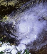
Hurricane Lenny was the strongest November Atlantic hurricane
on record. It was the twelfth tropical storm, eighth hurricane
, and record-breaking fifth Category 4 hurricane in the 1999 Atlantic hurricane season
. Lenny formed on November 13 in the western Caribbean Sea
, and maintained an unprecedented west-to-east track for its entire duration. It attained hurricane status to the south of Jamaica
on November 15, and passed south of Hispaniola
and Puerto Rico
over the next few days. Lenny rapidly intensified over the northeastern Caribbean on November 17, attaining peak winds of 155 mph (250 km/h) while passing about 21 mi (33.8 km) south of Saint Croix in the United States Virgin Islands
. It gradually weakened while moving through the Leeward Islands
, eventually dissipating on November 23 over the open Atlantic Ocean.
Before moving through the Lesser Antilles, Lenny produced rough surf that killed two people in northern Colombia
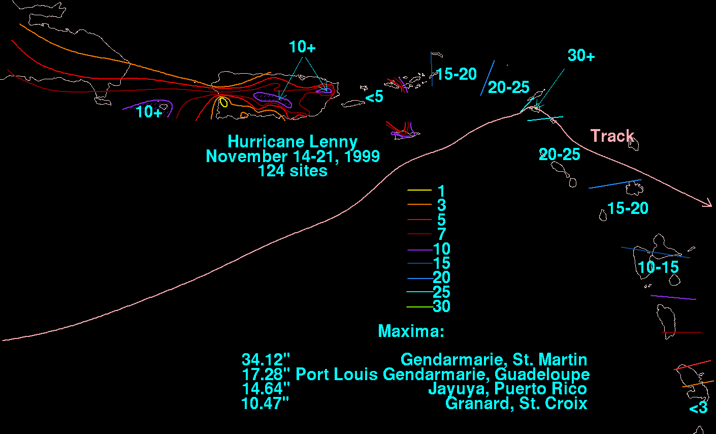
. Strong winds and rainfall resulted in heavy crop damage in southeastern Puerto Rico. Despite the hurricane passing near Saint Croix at peak intensity, damage on the small island was only described as "moderate", although there was widespread flooding and erosion. Damage in the United States territories totaled about $330 million. The highest precipitation related to the storm occurred at Gendarmerie on the French side of Saint Martin
, where a total of 34.12 in (866.6 mm) was recorded. On the island, the hurricane destroyed over 200 properties, and there were three deaths. In nearby Antigua and Barbuda
, torrential rainfall contaminated the water supply and killed one person. Significant storm damage occurred as far south as Grenada
, where high surf isolated towns from the capital city.
that was first observed in the southwestern Caribbean Sea on November 8. It developed an area of convective that day, although for the next few days the system remained poorly defined. Thunderstorms spread across the region, producing heavy rainfall in portions of Mexico and Central America. On November 13, the system began becoming better organized, and a Hurricane Hunters
flight later that day discovered a surface circulation
and winds of about 35 mph (55 km/h). The data indicated the development
of Tropical Depression Sixteen at 1800 UTC
about 175 mi (280 km) south of the Cayman Islands
. Upon first becoming a tropical cyclone, the depression's convection was fairly disorganized, and the National Hurricane Center
did not anticipate any strengthening for three days. For much of its duration, the tropical cyclone
maintained a track from west to east across the Caribbean Sea, which was unprecedented in the Atlantic hurricane database. The path resulted from its movement along the southern end of a trough
over the western Atlantic Ocean that extended from the lower to the upper levels of the atmosphere.
Following its formation, the depression gradually became better organized, and on November 14 the National Hurricane Center
(NHC) upgraded it to Tropical Storm Lenny, based on reports from the Hurricane Hunters. When the cyclone was operationally found to have reached tropical storm status, it already had winds of 65 mph (100 km/h) as well as a developing eye feature
. At 0000 UTC on November 15, Lenny attained hurricane status about 175 mi (280 km) southwest of Kingston, Jamaica
. The quick intensification was unexpected and occurred after a large area of convection blossomed over the center. At the same time, Lenny developed an anticyclone
aloft, which provided favorable conditions for development. After moving east-southeastward for the early part of its duration, the hurricane turned more to the east on November 15. The Hurricane Hunters reported winds of 100 mph (160 km/h), which made Lenny a Category 2 on the Saffir-Simpson Hurricane Scale
. However, the cloud patter subsequently became less organized as the eye disappeared, and Lenny weakened to winds of 85 mph (140 km/h) while passing south of Hispaniola. After the unexplained weakening, the Hurricane Hunters reported that the eye had reformed and that the hurricane reached 100 mph (160 km/h) winds. At the time, a ridge
was expected to build to its east, which would result in Lenny turning northeastward and hitting Puerto Rico
24 hours later.
Beginning on November 16, Hurricane Lenny underwent a 24 hour period of rapid deepening
, reaching major hurricane status about 165 mi (265 km) south of the Mona Passage
. At that point, it had well-defined banding features
, good outflow
, and a circular eye visible from the radar in San Juan, Puerto Rico
. The hurricane continued to become better organized, with an eye 29 mi (46 km) in diameter surrounded by a closed eyewall. Around 1200 UTC on November 17, Lenny intensified into a Category 4 hurricane as it approached the islands of the northeastern Caribbean. This was the fifth Category 4 of the season, which set a record for the most hurricanes of that intensity in a season. Around that time, it made its closest approach to Puerto Rico, passing about 75 mi (120.7 km) southeast of Maunabo
. Shortly thereafter, the hurricane attained peak winds of 155 mph (250 km/h) while passing 21 mi (33 km) south of the island of Saint Croix
in the United States Virgin Islands
. This made it the strongest November hurricane on record, and at the time it was one of only four November major hurricanes; it was later joined by Hurricane Michelle
in 2001 and Hurricane Paloma in 2008. Hurricane Hunters reported Lenny's peak winds in the southeastern portion of the hurricane; the group also reported a minimum pressure
of 933 mbar, which was a drop of 34 mbar in 24 hours. In addition, a dropsonde
recorded winds of 210 mph (339 km/h) while descending to the surface; at the time, this was the highest dropsonde wind speed in a hurricane.
Around the time it peaked in intensity, Lenny slowed its motion due to moving between two ridges. Despite favorable conditions, the hurricane began weakening as it turned to an eastward drift, possibly due to upwelling
of cooler waters. Late on November 18, the eye of Lenny moved over Saint Martin
with winds of 125 mph (205 km/h). Continuing to weaken, the hurricane struck Anguilla
and Saint Barthélemy
the next day. It turned southeastward while still drifting, bringing heavy rainfall and strong winds to the islands across the northeastern Caribbean. Late on November 19, Lenny weakened to tropical storm intensity, after the center became exposed from the convection due to increased wind shear
. Early on November 20, the storm made landfall on Anguilla
, although by that time the center had become difficult to locate. Later that day, the cyclone exited the Caribbean, continuing its southeast track. On November 21, Lenny turned to the northeast and weakened to a tropical depression. The deep convection was located at least 100 mi (160 km) east of the increasingly elongated center. Lenny turned to the east for the final time early on November 22, dissipating the next day about 690 mi (1110 km) east of the Lesser Antilles.
 Early in Lenny's duration, a tropical storm warning
and hurricane watch were issued for Jamaica and later the southern coast of the Dominican Republic, and only a hurricane watch was issued for the southern coast of Haiti. Haitian officials declared a state of alert in three southern provinces and allocated about $1 million (1999 USD) in hurricane funds. Residents in flood-prone areas were advised to evacuate in southern Haiti, as well as in neighboring Dominican Republic.
A hurricane watch was issued for Puerto Rico and the Virgin Islands
late on November 15, which was upgraded to a hurricane warning six hours later. By that time Lenny was projected to move over Puerto Rico. After Lenny made its closest approach to the island, the hurricane warning was downgraded to a tropical storm warning on November 17, which was discontinued the following day along with the advisories in the Virgin Islands. In Puerto Rico, the media maintained continuous coverage on the hurricane based on statements and warnings from the San Juan
National Weather Service
office. Based on the coverage, the public was well-informed of the threat of the hurricane on the island. Before the storm and as a result of its impact, around 4700 people evacuated to 191 shelters island-wide. This included 1,190 residents in Ponce
who evacuated to 27 schools, as well as 584 people in western Puerto Rico. Officials closed all schools, banned the sale of alcohol, and ordered a freeze on the price of emergency supplies. The Federal Emergency Management Agency
(FEMA) activated six medical assistance teams, three medical support teams, and two advance medical assessment units. The agency stored five days' worth of food in schools in the U.S. Virgin Islands. Before the hurricane's arrival, U.S. Virgin Islands governor Charles Wesley Turnbull
declared a state of emergency. In St. Croix, 309 people rode out the storm in shelters. Officials opened eight shelters in the British Virgin Islands
. There, airlines and hotels assisted in evacuating tourists away from the area.
Governments across the eastern Caribbean issued hurricane warnings as far south as Montserrat
. In Anguilla, residents near the coast were advised to evacuate. Schools closed ahead of the storm, and the ferry between the island and Saint Martin was halted and moved to a safe location. In Saint Kitts and Nevis, the National Emergency Management Agency was activated on November 16. Officials there advised residents living near ghauts
to evacuate, and one shelter was located in each district of the country. In addition, stores were open for longer hours to allow people to stock up on supplies. Most businesses and schools were closed in Antigua and Barbuda during the storm, while in Dominica, the airport was closed. Further south, there was little warning for the hurricane in Grenada, and most people left their boats in the water.
Across the eastern Caribbean, Hurricane Lenny damaged vital infrastructure, including roads and piers, in the tourism-dependent islands. Most of the islands' tourism areas were on western-facing beaches, many of which were unprepared for the high waves and winds produced by Lenny.
in Colombia
, sinking two boats and flooding 1200 houses. There were also reports of flooded businesses and damaged crops. In the country, strong winds on the storm's fringe killed a man after striking him with a beam. Although there were initial reports of nine people missing, the death toll in Colombia was set at two. Two sailors were killed when their yacht was lost in the southern Caribbean Sea
.
Along the ABC Islands off the north coast of Venezuela, the hurricane produced strong waves from 10–20 ft (3–6 m) along the islands; southwest coastlines. The waves left heavy beach erosion, as well as coastal damage to properties and boats.
In Jamaica, the hurricane dropped heavy rainfall but left little damage. Rains in the Dominican Republic caused flooding in the country's southwest portion. Flooding around Les Cayes
in southwestern Haiti destroyed 60% of the rice, corn and banana plantations, while high waves wrecked several houses in Cavaellon
.
Hurricane Lenny was originally forecast to strike Puerto Rico, although it remained to the south of the island. The hurricane began affecting the island with gusty winds and heavy rainfall on November 17. Rainfall in the days prior to Lenny's approach left areas susceptible to flooding, which caused many rivers in the northeastern portion of the island to exceed their banks following the storm. Such flooding forced towns to evacuate along the rivers, and also resulted in the closure of secondary and primary highways. The heavy rains also caused mudslides and rockslides. The peak rainfall on the island was 14.64 in (371.9 mm) in Jayuya
in central Puerto Rico. Tides
in San Juan
were about 1.8 ft (0.55 m) above normal. There, high seas washed a 546 ft (166.4 m) freighter ashore. Winds in the Puerto Rican mainland were not significant, gusting to 48 mph (77.2 km/h) in Ceiba
. The storm left 22,000 people without power and 103,000 people without water. Due to the heavy rainfall, about 200 farmers in southeastern Puerto Rico sustained about $19 million in crop damage (1999 USD). In the affected region, the heavy rainfall destroyed 80% of the vegetables and 50% of the plantains. Damage throughout the island totaled $105 million (1999 US).
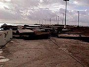
, although its strongest winds remained southeast of the island. There, gusts reached 112 mph (180 km/h), while sustained winds officially peaked around 70 mph (120 km/h). Strong winds damaged the roofs of many houses in eastern St. Croix, and also knocking down trees and power lines. The winds left severe damage to vegetation after fruits and vegetables were blown away. Rainfall peaked at 10.47 in (265.9 mm), which caused widespread flooding of many properties in the island's western portion. In Frederiksted, the hurricane produced a storm surge
of 15–20 ft (4.5–6 m), along with high waves that washed out roads and damaged coastal structures. There was also severe beach erosion in western St. Croix; high waves dumped 6.5 ft (2 m) of sand onto coastal roads about 100 ft (30.5 m) inland, and also washed washed several boats ashore. The National Weather Service described the damage as "moderate".
Elsewhere in the U.S. Virgin Islands, Lenny produced a storm surge of about 1.8 ft (0.54864 m) in St. Thomas
. Sustained winds on the island reached 53 mph (85 km/h) at the Cyril E. King Airport
, with gusts to 70 mph (120 km/h). On nearby St. John
, wind gusts reached 92 mph (148 km/h). Rains were not as heavy as on St. Croix; the maximum amounts were 4.34 in (110.2 mm) on St. Thomas and 2.95 in (74.9 mm) on St. John. Both islands reported beach erosion along their southern coastlines. Damage on St. Thomas was minimal, limited to minor flooding and mudslides. The Virgin Islands National Park
in St. John reported over $1.6 million in damage (1999 USD). Between Puerto Rico and the U.S. Virgin Islands, the hurricane left about $330 million in damage (1999 USD), although there were no deaths in the territories.
In Virgin Gorda
in the nearby British Virgin Islands, the hurricane produced sustained winds of 55 mph (88.5 km/h), with gusts to 85 mph (136.8 km/h). Rainfall amounted to around 4 in (101.6 mm), and caused a mudslide near Coxheath. High waves eroded a portion of Sir Francis Drake Highway, and the high winds destroyed the roof of an apartment. Property damage in the British Virgin Islands totaled $5.6 million (1999 USD); however, the damage combined with the loss of tourism and productivity yielded a loss of $22 million to the islands' economy, or 3.1% of the gross domestic product
.
 The eye of Lenny moved over Anguilla
, an island located east of the British Virgin Islands. Localized flooding was reported, including in the capital The Valley
where waters reportedly reached a depth of 14 ft (4.3 m). The hurricane struck only a month after Hurricane Jose
had affected the region, causing significant beach erosion along Anguilla's coastline. Damage from Lenny amounted to $65.8 million.
Saint Barthélemy
and the SSS Islands, which include Saba, Sint Eustatius, and Saint Martin
, were in the path of Hurricane Lenny on November 18 through the subsequent day. On Saint Barthélemy, the hurricane produced record-breaking precipitation of around 15 in (381 mm). Waves reached 16 ft (4.9 m) on the island's western portion. On Saba, there was an unofficial wind gust of 167 mph (268 km/h) before the instrument blew away. The island sustained damage to several buildings, including to airport facilities. The highest precipitation related to the storm occurred at Gendarmerie on the French side of Saint Martin, where a total of 34.12 in (866.6 mm) was recorded. This included a record 24-hour total of 18.98 in (482.1 mm). On the Dutch side of the island, rainfall peaked at 27.56 in (700 mm) in Philipsburg. The rains resulted in mudslides and flooding, and were the primary form of impact on the island. For 36 hours, Saint Martin experienced tropical-storm conditions, and there were three times when the winds surpassed hurricane force. Sustained winds on the island peaked at 84 mph (135.2 km/h) at the Princess Juliana International Airport
, where a gust of 104 mph (167.4 km/h) was also reported. The sustained wind report at the airport was the highest land observation from Lenny.
Due to the hurricane's unusual track from the west, it produced unparalleled waves of 10–16 (3–5 m) along the western coast of St. Martin, which damaged or destroyed many boats. During its passage, Lenny left widespread damage to the infrastructure, including to the airport, harbor, resorts, power utilities, schools, and hospitals. As a result, the three SSS Islands sustained power and telephone outages. There was widespread destruction of the roofs of houses across the island, and over 200 houses were destroyed. Damage was estimated at $69 million, and there were three deaths on the Dutch side of St. Martin. Two of the deaths were from flying debris, and the other was due to a collapsed roadway.
While passing over Antigua, Hurricane Lenny dropped 18.32 in (465.3 mm) at the V. C. Bird International Airport, while locations in the southern portion recorded over 25 in (635 mm). The rainfall caused severe flooding in Antigua, resulting in landslides in the northwestern and southern portion of the island. Flooding washed out major roadways, including one bridge. Along the coast the storm caused severe beach erosion. About 65% of Barbuda experienced flooding due to the rainfall, due to the island's flat topography. The flooding contaminated the water storage facilities as well as all private wells. About 95% of the crops in Barbuda were destroyed. Damage in the country of Antigua and Barbuda
totaled $51.3 million, and there was one death.
The hurricane's waves reached 20 ft (6.1 m) along the coasts of Saint Kitts and Nevis
, reaching up to 600 ft (182.9 m) inland. Several businesses were flooded, and some beach erosion was reported. The hurricane destroyed 46 homes and damaged 332 others to varying degree. Four families required evacuation because of the damage to their residences. Heavy rains caused mudslides on Saint Kitts, and heavy damage occurred in Old Road Town
. Damage in the country amounted to $41.4 million. In Montserrat, damage was reported along its western coastline. After high waves capsized a boat, a crew of three required rescue. Guadeloupe
received record precipitation amounts in some areas, generally ranging from 6–12 in (150–300 mm). On Grande-Terre
, the eastern island of Guadeloupe, the hurricane produced a significant wave height
of 9.8 ft (3 m), with estimates as high as 13 ft (4 m). There were five deaths in Guadeloupe. Damage was heaviest along the western portion, due to the waves, as well as inland from flooding.
In Dominica, high waves damaged the island's western coastal highway, leaving the most heavily-traveled road temporarily closed. Road closures cut off links between towns on the island. The hurricane destroyed at least 50 homes, including 3 that were washed away by the waves. Hotels along the island's west coast sustained heavy damage, and across the nation the hurricane's impact was worse than that from Hurricane Luis
four years prior. Damage on the island totaled $21.5 million. Rainfall of around 3 in (76.2 mm) reached as far south as Martinique
, where one person was killed. Further south, high waves in Saint Lucia
washed away beaches, a seawall, and coastal walkways. At least 40 houses were damaged along the coast, which left several families homeless. Damage in the country totaled $6.6 million. In Saint Vincent and the Grenadines
, the hurricane washed away four buildings and damaged five others. About 50 people were left homeless in the country.
In western Grenada
, high waves affected much of the coastline, destroying 21 small boats and causing significant beach erosion. The waves covered the entire Grand Anse Beach in Saint George Parish
. The erosion heavily impacted tourist areas and also threatened the foundation of the runway at the Maurice Bishop International Airport. Storm damage cut off the towns in western Grenada from the capital city of Saint George's. The cut off roads resulted in an island-wide fuel shortage. In Saint John Parish
, the storm knocked out the water and power supply, and also forced several families to evacuate their damaged houses. The small island Carriacou, located north of Grenada, sustained damage to the road to its primary airport. At least 10 homes were destroyed in the country, and damage in the country totaled $94.6 million; this represented 27% of its gross domestic product
(GDP). Effects from the storm reached as far south as Trinidad and Tobago
. In the country, storm surge caused damage to boats and coastal structures, while beach erosion was reported in Tobago.
 Following heavy damage to the coral reef around Curaçao
, workers placed reef balls
to assist in replenishing the damaged structure. In Puerto Rico, workers quickly responded to power and water outages. Similarly on Saint Croix, power systems were quickly restored. On November 23, U.S. President Bill Clinton
declared the U.S. Virgin Islands as a disaster area; this allocated federal funding for loans to public and private entities, as well as providing 75% of the cost of debris removal. By 23 days after the hurricane struck, nearly 3,000 residents applied for assistance, mostly on St. Croix. In response, the federal government provided about $480,000 to the affected people. The United States Office of Foreign Disaster Assistance
provided $185,000, mostly directed toward the United Nations Development Programme
, for aid to other islands in the eastern Caribbean. Other agencies, including the Caribbean Development Bank
, the United Kingdom's Department for International Development
, and the European Union
, provided $1.1 million in assistance.
In response to the damage on Saint Martin, officials in the Netherlands Antilles
issued an appeal to the European Parliament
for assistance from the international community. Due to their small population and area, the small islands of the eastern Caribbean required international funding to repair the damage from the hurricane and return to normalcy. In Antigua and Barbuda, officials worked quickly to repair roads and clean Barbuda's water system. However, 20,000 people in Antigua remained without water by a week after the hurricane, and the stagnant water caused an increase in mosquitoes. The government of Dominica provided 42 families with temporary shelters. With a loan from the Caribbean Development Bank, the government worked to complete a sea wall along a highway south of its capital Roseau. The Saint Lucian government likewise provided 70 of their families with housing. In Grenada, workers repaired the road system to provide proper fuel access to the island, and also began the process of reclaiming land near its airport to mitigate erosion. Regions in Antigua and Grenada were declared disaster areas. Across the eastern Caribbean, local Red Cross offices provided food and shelter to affected citizens. High damage to tourist areas caused a decrease in cruise lines. A damaged hotel in Nevis left 800 people unemployed due to its closure.
Due to its effects, the name Lenny was retired by the World Meteorological Organization
and will never again be used for an Atlantic hurricane. The name was replaced with Lee in the 2005 Atlantic hurricane season
.
Atlantic hurricane
North Atlantic tropical cyclones usually form in the northern hemisphere summer or fall. Tropical cyclones can be categorized by intensity. Tropical storms have one-minute maximum sustained winds of at least 39 mph , while hurricanes have one-minute maximum sustained exceeding 74 mph...
on record. It was the twelfth tropical storm, eighth hurricane
Tropical cyclone
A tropical cyclone is a storm system characterized by a large low-pressure center and numerous thunderstorms that produce strong winds and heavy rain. Tropical cyclones strengthen when water evaporated from the ocean is released as the saturated air rises, resulting in condensation of water vapor...
, and record-breaking fifth Category 4 hurricane in the 1999 Atlantic hurricane season
1999 Atlantic hurricane season
The 1999 Atlantic hurricane season officially began on June 1, 1999, and lasted until November 30, 1999. These dates conventionally delimit the period of each year when most tropical cyclones form in the Atlantic basin....
. Lenny formed on November 13 in the western Caribbean Sea
Caribbean Sea
The Caribbean Sea is a sea of the Atlantic Ocean located in the tropics of the Western hemisphere. It is bounded by Mexico and Central America to the west and southwest, to the north by the Greater Antilles, and to the east by the Lesser Antilles....
, and maintained an unprecedented west-to-east track for its entire duration. It attained hurricane status to the south of Jamaica
Jamaica
Jamaica is an island nation of the Greater Antilles, in length, up to in width and 10,990 square kilometres in area. It is situated in the Caribbean Sea, about south of Cuba, and west of Hispaniola, the island harbouring the nation-states Haiti and the Dominican Republic...
on November 15, and passed south of Hispaniola
Hispaniola
Hispaniola is a major island in the Caribbean, containing the two sovereign states of the Dominican Republic and Haiti. The island is located between the islands of Cuba to the west and Puerto Rico to the east, within the hurricane belt...
and Puerto Rico
Puerto Rico
Puerto Rico , officially the Commonwealth of Puerto Rico , is an unincorporated territory of the United States, located in the northeastern Caribbean, east of the Dominican Republic and west of both the United States Virgin Islands and the British Virgin Islands.Puerto Rico comprises an...
over the next few days. Lenny rapidly intensified over the northeastern Caribbean on November 17, attaining peak winds of 155 mph (250 km/h) while passing about 21 mi (33.8 km) south of Saint Croix in the United States Virgin Islands
United States Virgin Islands
The Virgin Islands of the United States are a group of islands in the Caribbean that are an insular area of the United States. The islands are geographically part of the Virgin Islands archipelago and are located in the Leeward Islands of the Lesser Antilles.The U.S...
. It gradually weakened while moving through the Leeward Islands
Leeward Islands
The Leeward Islands are a group of islands in the West Indies. They are the northern islands of the Lesser Antilles chain. As a group they start east of Puerto Rico and reach southward to Dominica. They are situated where the northeastern Caribbean Sea meets the western Atlantic Ocean...
, eventually dissipating on November 23 over the open Atlantic Ocean.
Before moving through the Lesser Antilles, Lenny produced rough surf that killed two people in northern Colombia
Colombia
Colombia, officially the Republic of Colombia , is a unitary constitutional republic comprising thirty-two departments. The country is located in northwestern South America, bordered to the east by Venezuela and Brazil; to the south by Ecuador and Peru; to the north by the Caribbean Sea; to the...
. Strong winds and rainfall resulted in heavy crop damage in southeastern Puerto Rico. Despite the hurricane passing near Saint Croix at peak intensity, damage on the small island was only described as "moderate", although there was widespread flooding and erosion. Damage in the United States territories totaled about $330 million. The highest precipitation related to the storm occurred at Gendarmerie on the French side of Saint Martin
Saint Martin
Saint Martin is an island in the northeast Caribbean, approximately east of Puerto Rico. The 87 km2 island is divided roughly 60/40 between France and the Kingdom of the Netherlands ; however, the Dutch side has the larger population. It is one of the smallest sea islands divided between...
, where a total of 34.12 in (866.6 mm) was recorded. On the island, the hurricane destroyed over 200 properties, and there were three deaths. In nearby Antigua and Barbuda
Antigua and Barbuda
Antigua and Barbuda is a twin-island nation lying between the Caribbean Sea and the Atlantic Ocean. It consists of two major inhabited islands, Antigua and Barbuda, and a number of smaller islands...
, torrential rainfall contaminated the water supply and killed one person. Significant storm damage occurred as far south as Grenada
Grenada
Grenada is an island country and Commonwealth Realm consisting of the island of Grenada and six smaller islands at the southern end of the Grenadines in the southeastern Caribbean Sea...
, where high surf isolated towns from the capital city.
Meteorological history
The origins of Hurricane Lenny were from a low pressure areaLow pressure area
A low-pressure area, or "low", is a region where the atmospheric pressure at sea level is below that of surrounding locations. Low-pressure systems form under areas of wind divergence which occur in upper levels of the troposphere. The formation process of a low-pressure area is known as...
that was first observed in the southwestern Caribbean Sea on November 8. It developed an area of convective that day, although for the next few days the system remained poorly defined. Thunderstorms spread across the region, producing heavy rainfall in portions of Mexico and Central America. On November 13, the system began becoming better organized, and a Hurricane Hunters
Hurricane Hunters
The Hurricane Hunters are aircraft that fly into tropical cyclones in the North Atlantic Ocean and Northeastern Pacific Ocean for the specific purpose of directly measuring weather data in and around those storms. In the United States, the Air Force, Navy, and NOAA units have all participated in...
flight later that day discovered a surface circulation
Atmospheric circulation
Atmospheric circulation is the large-scale movement of air, and the means by which thermal energy is distributed on the surface of the Earth....
and winds of about 35 mph (55 km/h). The data indicated the development
Tropical cyclogenesis
Tropical cyclogenesis is the term that describes the development and strengthening of a tropical cyclone in the atmosphere. The mechanisms through which tropical cyclogenesis occurs are distinctly different from those through which mid-latitude cyclogenesis occurs...
of Tropical Depression Sixteen at 1800 UTC
Coordinated Universal Time
Coordinated Universal Time is the primary time standard by which the world regulates clocks and time. It is one of several closely related successors to Greenwich Mean Time. Computer servers, online services and other entities that rely on having a universally accepted time use UTC for that purpose...
about 175 mi (280 km) south of the Cayman Islands
Cayman Islands
The Cayman Islands is a British Overseas Territory and overseas territory of the European Union located in the western Caribbean Sea. The territory comprises the three islands of Grand Cayman, Cayman Brac, and Little Cayman, located south of Cuba and northwest of Jamaica...
. Upon first becoming a tropical cyclone, the depression's convection was fairly disorganized, and the National Hurricane Center
National Hurricane Center
The National Hurricane Center , located at Florida International University in Miami, Florida, is the division of the National Weather Service responsible for tracking and predicting weather systems within the tropics between the Prime Meridian and the 140th meridian west poleward to the 30th...
did not anticipate any strengthening for three days. For much of its duration, the tropical cyclone
Tropical cyclone
A tropical cyclone is a storm system characterized by a large low-pressure center and numerous thunderstorms that produce strong winds and heavy rain. Tropical cyclones strengthen when water evaporated from the ocean is released as the saturated air rises, resulting in condensation of water vapor...
maintained a track from west to east across the Caribbean Sea, which was unprecedented in the Atlantic hurricane database. The path resulted from its movement along the southern end of a trough
Trough (meteorology)
A trough is an elongated region of relatively low atmospheric pressure, often associated with fronts.Unlike fronts, there is not a universal symbol for a trough on a weather chart. The weather charts in some countries or regions mark troughs by a line. In the United States, a trough may be marked...
over the western Atlantic Ocean that extended from the lower to the upper levels of the atmosphere.
Following its formation, the depression gradually became better organized, and on November 14 the National Hurricane Center
National Hurricane Center
The National Hurricane Center , located at Florida International University in Miami, Florida, is the division of the National Weather Service responsible for tracking and predicting weather systems within the tropics between the Prime Meridian and the 140th meridian west poleward to the 30th...
(NHC) upgraded it to Tropical Storm Lenny, based on reports from the Hurricane Hunters. When the cyclone was operationally found to have reached tropical storm status, it already had winds of 65 mph (100 km/h) as well as a developing eye feature
Eye (cyclone)
The eye is a region of mostly calm weather found at the center of strong tropical cyclones. The eye of a storm is a roughly circular area and typically 30–65 km in diameter. It is surrounded by the eyewall, a ring of towering thunderstorms where the second most severe weather of a cyclone...
. At 0000 UTC on November 15, Lenny attained hurricane status about 175 mi (280 km) southwest of Kingston, Jamaica
Kingston, Jamaica
Kingston is the capital and largest city of Jamaica, located on the southeastern coast of the island. It faces a natural harbour protected by the Palisadoes, a long sand spit which connects the town of Port Royal and the Norman Manley International Airport to the rest of the island...
. The quick intensification was unexpected and occurred after a large area of convection blossomed over the center. At the same time, Lenny developed an anticyclone
Anticyclone
An anticyclone is a weather phenomenon defined by the United States' National Weather Service's glossary as "[a] large-scale circulation of winds around a central region of high atmospheric pressure, clockwise in the Northern Hemisphere, counterclockwise in the Southern Hemisphere"...
aloft, which provided favorable conditions for development. After moving east-southeastward for the early part of its duration, the hurricane turned more to the east on November 15. The Hurricane Hunters reported winds of 100 mph (160 km/h), which made Lenny a Category 2 on the Saffir-Simpson Hurricane Scale
Saffir-Simpson Hurricane Scale
The Saffir–Simpson Hurricane Scale , or the Saffir–Simpson Hurricane Wind Scale , classifies hurricanes — Western Hemisphere tropical cyclones that exceed the intensities of tropical depressions and tropical storms — into five categories distinguished by the intensities of their sustained winds...
. However, the cloud patter subsequently became less organized as the eye disappeared, and Lenny weakened to winds of 85 mph (140 km/h) while passing south of Hispaniola. After the unexplained weakening, the Hurricane Hunters reported that the eye had reformed and that the hurricane reached 100 mph (160 km/h) winds. At the time, a ridge
Ridge (meteorology)
A ridge is an elongated region of relatively high atmospheric pressure, the opposite of a trough....
was expected to build to its east, which would result in Lenny turning northeastward and hitting Puerto Rico
Puerto Rico
Puerto Rico , officially the Commonwealth of Puerto Rico , is an unincorporated territory of the United States, located in the northeastern Caribbean, east of the Dominican Republic and west of both the United States Virgin Islands and the British Virgin Islands.Puerto Rico comprises an...
24 hours later.
Beginning on November 16, Hurricane Lenny underwent a 24 hour period of rapid deepening
Rapid deepening
Rapid deepening, also known as rapid intensification, is a meteorological condition that occurs when the minimum sea-level atmospheric pressure of a tropical cyclone decreases drastically in a short period of time. The National Weather Service describes rapid deepening as a decrease of...
, reaching major hurricane status about 165 mi (265 km) south of the Mona Passage
Mona Passage
The Mona Passage is a strait that separates the islands of Hispaniola and Puerto Rico. The Mona Passage connects the Atlantic Ocean to the Caribbean Sea, and is an important shipping route between the Atlantic and the Panama Canal....
. At that point, it had well-defined banding features
Rainband
A rainband is a cloud and precipitation structure associated with an area of rainfall which is significantly elongated. Rainbands can be stratiform or convective, and are generated by differences in temperature. When noted on weather radar imagery, this precipitation elongation is referred to as...
, good outflow
Outflow (meteorology)
Outflow, in meteorology, is air that flows outwards from a storm system. It is associated with ridging, or anticyclonic flow. In the low levels of the troposphere, outflow radiates from thunderstorms in the form of a wedge of rain-cooled air, which is visible as a thin rope-like cloud on weather...
, and a circular eye visible from the radar in San Juan, Puerto Rico
San Juan, Puerto Rico
San Juan , officially Municipio de la Ciudad Capital San Juan Bautista , is the capital and most populous municipality in Puerto Rico, an unincorporated territory of the United States. As of the 2010 census, it had a population of 395,326 making it the 46th-largest city under the jurisdiction of...
. The hurricane continued to become better organized, with an eye 29 mi (46 km) in diameter surrounded by a closed eyewall. Around 1200 UTC on November 17, Lenny intensified into a Category 4 hurricane as it approached the islands of the northeastern Caribbean. This was the fifth Category 4 of the season, which set a record for the most hurricanes of that intensity in a season. Around that time, it made its closest approach to Puerto Rico, passing about 75 mi (120.7 km) southeast of Maunabo
Maunabo, Puerto Rico
Maunabo is a municipality of Puerto Rico located in the southeastern coast, northeast of Patillas and south of Yabucoa. Maunabo is spread over 8 wards and Maunabo Pueblo . It is part of the San Juan-Caguas-Guaynabo Metropolitan Statistical Area.The Mayor of the town is Jorge L. Márquez Pérez...
. Shortly thereafter, the hurricane attained peak winds of 155 mph (250 km/h) while passing 21 mi (33 km) south of the island of Saint Croix
Saint Croix, U.S. Virgin Islands
Saint Croix is an island in the Caribbean Sea, and a county and constituent district of the United States Virgin Islands , an unincorporated territory of the United States. Formerly the Danish West Indies, they were sold to the United States by Denmark in the Treaty of the Danish West Indies of...
in the United States Virgin Islands
United States Virgin Islands
The Virgin Islands of the United States are a group of islands in the Caribbean that are an insular area of the United States. The islands are geographically part of the Virgin Islands archipelago and are located in the Leeward Islands of the Lesser Antilles.The U.S...
. This made it the strongest November hurricane on record, and at the time it was one of only four November major hurricanes; it was later joined by Hurricane Michelle
Hurricane Michelle
Hurricane Michelle was the thirteenth named storm and the strongest tropical cyclone of the 2001 Atlantic hurricane season. Michelle developed from a tropical wave that moved across the Atlantic, and formed into Tropical Depression Fifteen on the October 29. The depression slowly intensified as...
in 2001 and Hurricane Paloma in 2008. Hurricane Hunters reported Lenny's peak winds in the southeastern portion of the hurricane; the group also reported a minimum pressure
Atmospheric pressure
Atmospheric pressure is the force per unit area exerted into a surface by the weight of air above that surface in the atmosphere of Earth . In most circumstances atmospheric pressure is closely approximated by the hydrostatic pressure caused by the weight of air above the measurement point...
of 933 mbar, which was a drop of 34 mbar in 24 hours. In addition, a dropsonde
Dropsonde
A dropsonde is a weather reconnaissance device created by the National Center for Atmospheric Research , designed to be dropped from an aircraft at altitude to more accurately measure tropical storm conditions as the device falls to the surface...
recorded winds of 210 mph (339 km/h) while descending to the surface; at the time, this was the highest dropsonde wind speed in a hurricane.
Around the time it peaked in intensity, Lenny slowed its motion due to moving between two ridges. Despite favorable conditions, the hurricane began weakening as it turned to an eastward drift, possibly due to upwelling
Upwelling
Upwelling is an oceanographic phenomenon that involves wind-driven motion of dense, cooler, and usually nutrient-rich water towards the ocean surface, replacing the warmer, usually nutrient-depleted surface water. The increased availability in upwelling regions results in high levels of primary...
of cooler waters. Late on November 18, the eye of Lenny moved over Saint Martin
Saint Martin
Saint Martin is an island in the northeast Caribbean, approximately east of Puerto Rico. The 87 km2 island is divided roughly 60/40 between France and the Kingdom of the Netherlands ; however, the Dutch side has the larger population. It is one of the smallest sea islands divided between...
with winds of 125 mph (205 km/h). Continuing to weaken, the hurricane struck Anguilla
Anguilla
Anguilla is a British overseas territory and overseas territory of the European Union in the Caribbean. It is one of the most northerly of the Leeward Islands in the Lesser Antilles, lying east of Puerto Rico and the Virgin Islands and directly north of Saint Martin...
and Saint Barthélemy
Saint Barthélemy
Saint Barthélemy , officially the Territorial collectivity of Saint Barthélemy , is an overseas collectivity of France. Often abbreviated to Saint-Barth in French, or St. Barts in English, the indigenous people called the island Ouanalao...
the next day. It turned southeastward while still drifting, bringing heavy rainfall and strong winds to the islands across the northeastern Caribbean. Late on November 19, Lenny weakened to tropical storm intensity, after the center became exposed from the convection due to increased wind shear
Wind shear
Wind shear, sometimes referred to as windshear or wind gradient, is a difference in wind speed and direction over a relatively short distance in the atmosphere...
. Early on November 20, the storm made landfall on Anguilla
Anguilla
Anguilla is a British overseas territory and overseas territory of the European Union in the Caribbean. It is one of the most northerly of the Leeward Islands in the Lesser Antilles, lying east of Puerto Rico and the Virgin Islands and directly north of Saint Martin...
, although by that time the center had become difficult to locate. Later that day, the cyclone exited the Caribbean, continuing its southeast track. On November 21, Lenny turned to the northeast and weakened to a tropical depression. The deep convection was located at least 100 mi (160 km) east of the increasingly elongated center. Lenny turned to the east for the final time early on November 22, dissipating the next day about 690 mi (1110 km) east of the Lesser Antilles.
Preparations
Tropical cyclone warnings and watches
Warnings and watches are two levels of alert issued by national weather forecasting bodies to coastal areas threatened by the imminent approach of a tropical cyclone of tropical storm or hurricane intensity. They are notices to the local population and civil authorities to make appropriate...
and hurricane watch were issued for Jamaica and later the southern coast of the Dominican Republic, and only a hurricane watch was issued for the southern coast of Haiti. Haitian officials declared a state of alert in three southern provinces and allocated about $1 million (1999 USD) in hurricane funds. Residents in flood-prone areas were advised to evacuate in southern Haiti, as well as in neighboring Dominican Republic.
A hurricane watch was issued for Puerto Rico and the Virgin Islands
Virgin Islands
The Virgin Islands are the western island group of the Leeward Islands, which are the northern part of the Lesser Antilles, which form the border between the Caribbean Sea and the Atlantic Ocean...
late on November 15, which was upgraded to a hurricane warning six hours later. By that time Lenny was projected to move over Puerto Rico. After Lenny made its closest approach to the island, the hurricane warning was downgraded to a tropical storm warning on November 17, which was discontinued the following day along with the advisories in the Virgin Islands. In Puerto Rico, the media maintained continuous coverage on the hurricane based on statements and warnings from the San Juan
San Juan, Puerto Rico
San Juan , officially Municipio de la Ciudad Capital San Juan Bautista , is the capital and most populous municipality in Puerto Rico, an unincorporated territory of the United States. As of the 2010 census, it had a population of 395,326 making it the 46th-largest city under the jurisdiction of...
National Weather Service
National Weather Service
The National Weather Service , once known as the Weather Bureau, is one of the six scientific agencies that make up the National Oceanic and Atmospheric Administration of the United States government...
office. Based on the coverage, the public was well-informed of the threat of the hurricane on the island. Before the storm and as a result of its impact, around 4700 people evacuated to 191 shelters island-wide. This included 1,190 residents in Ponce
Ponce, Puerto Rico
Ponce is both a city and a municipality in the southern part of Puerto Rico. The city is the seat of the municipal government.The city of Ponce, the fourth most populated in Puerto Rico, and the most populated outside of the San Juan metropolitan area, is named for Juan Ponce de León y Loayza, the...
who evacuated to 27 schools, as well as 584 people in western Puerto Rico. Officials closed all schools, banned the sale of alcohol, and ordered a freeze on the price of emergency supplies. The Federal Emergency Management Agency
Federal Emergency Management Agency
The Federal Emergency Management Agency is an agency of the United States Department of Homeland Security, initially created by Presidential Reorganization Plan No. 1 of 1978 and implemented by two Executive Orders...
(FEMA) activated six medical assistance teams, three medical support teams, and two advance medical assessment units. The agency stored five days' worth of food in schools in the U.S. Virgin Islands. Before the hurricane's arrival, U.S. Virgin Islands governor Charles Wesley Turnbull
Charles Wesley Turnbull
Charles Wesley Turnbull , was the 26th Governor of the U.S. Virgin Islands.He was born on St. Thomas. Prior to being elected in 1998, he was a professor at the University of the Virgin Islands, Commissioner and Assistant Commissioner of the territorial Department of Education, principal and...
declared a state of emergency. In St. Croix, 309 people rode out the storm in shelters. Officials opened eight shelters in the British Virgin Islands
British Virgin Islands
The Virgin Islands, often called the British Virgin Islands , is a British overseas territory and overseas territory of the European Union, located in the Caribbean to the east of Puerto Rico. The islands make up part of the Virgin Islands archipelago, the remaining islands constituting the U.S...
. There, airlines and hotels assisted in evacuating tourists away from the area.
Governments across the eastern Caribbean issued hurricane warnings as far south as Montserrat
Montserrat
Montserrat is a British overseas territory located in the Leeward Islands, part of the chain of islands called the Lesser Antilles in the West Indies. This island measures approximately long and wide, giving of coastline...
. In Anguilla, residents near the coast were advised to evacuate. Schools closed ahead of the storm, and the ferry between the island and Saint Martin was halted and moved to a safe location. In Saint Kitts and Nevis, the National Emergency Management Agency was activated on November 16. Officials there advised residents living near ghauts
Ghat
Ghat is the capital of the Ghat District in the Fezzan region of southwestern Libya.-History:In historical times, Ghat was a major terminal point on the Trans-Saharan trade route and a major administrative center in the Fezzan...
to evacuate, and one shelter was located in each district of the country. In addition, stores were open for longer hours to allow people to stock up on supplies. Most businesses and schools were closed in Antigua and Barbuda during the storm, while in Dominica, the airport was closed. Further south, there was little warning for the hurricane in Grenada, and most people left their boats in the water.
Impact
| State/country | Deaths |
|---|---|
| Colombia Colombia Colombia, officially the Republic of Colombia , is a unitary constitutional republic comprising thirty-two departments. The country is located in northwestern South America, bordered to the east by Venezuela and Brazil; to the south by Ecuador and Peru; to the north by the Caribbean Sea; to the... |
2 |
| Saint Martin Saint Martin Saint Martin is an island in the northeast Caribbean, approximately east of Puerto Rico. The 87 km2 island is divided roughly 60/40 between France and the Kingdom of the Netherlands ; however, the Dutch side has the larger population. It is one of the smallest sea islands divided between... |
3 |
| Guadeloupe Guadeloupe Guadeloupe is an archipelago located in the Leeward Islands, in the Lesser Antilles, with a land area of 1,628 square kilometres and a population of 400,000. It is the first overseas region of France, consisting of a single overseas department. As with the other overseas departments, Guadeloupe... |
5 |
| Martinique Martinique Martinique is an island in the eastern Caribbean Sea, with a land area of . Like Guadeloupe, it is an overseas region of France, consisting of a single overseas department. To the northwest lies Dominica, to the south St Lucia, and to the southeast Barbados... |
1 |
| Offshore | 6 |
| Total | 17 |
Across the eastern Caribbean, Hurricane Lenny damaged vital infrastructure, including roads and piers, in the tourism-dependent islands. Most of the islands' tourism areas were on western-facing beaches, many of which were unprepared for the high waves and winds produced by Lenny.
Central Caribbean
Early in the its existence, Lenny produced large waves and high tides along the Guajira PeninsulaGuajira Peninsula
Guajira Peninsula , is a peninsula in northern Colombia and northwestern Venezuela in the Caribbean Sea...
in Colombia
Colombia
Colombia, officially the Republic of Colombia , is a unitary constitutional republic comprising thirty-two departments. The country is located in northwestern South America, bordered to the east by Venezuela and Brazil; to the south by Ecuador and Peru; to the north by the Caribbean Sea; to the...
, sinking two boats and flooding 1200 houses. There were also reports of flooded businesses and damaged crops. In the country, strong winds on the storm's fringe killed a man after striking him with a beam. Although there were initial reports of nine people missing, the death toll in Colombia was set at two. Two sailors were killed when their yacht was lost in the southern Caribbean Sea
Caribbean Sea
The Caribbean Sea is a sea of the Atlantic Ocean located in the tropics of the Western hemisphere. It is bounded by Mexico and Central America to the west and southwest, to the north by the Greater Antilles, and to the east by the Lesser Antilles....
.
Along the ABC Islands off the north coast of Venezuela, the hurricane produced strong waves from 10–20 ft (3–6 m) along the islands; southwest coastlines. The waves left heavy beach erosion, as well as coastal damage to properties and boats.
In Jamaica, the hurricane dropped heavy rainfall but left little damage. Rains in the Dominican Republic caused flooding in the country's southwest portion. Flooding around Les Cayes
Les Cayes
Les Cayes , is a town and seaport in southwestern Haiti, with a population of approximately 45,904 people . Estimates from 2008 place the population at close to 70,000 people...
in southwestern Haiti destroyed 60% of the rice, corn and banana plantations, while high waves wrecked several houses in Cavaellon
Cavaellon
Cavaellon is a rural town located in the Sud Department of Haiti.Its nearest neighbouring towns/cities are Nan Cotie , Saint-Louis-du-Sud , and Les Cayes ....
.
Hurricane Lenny was originally forecast to strike Puerto Rico, although it remained to the south of the island. The hurricane began affecting the island with gusty winds and heavy rainfall on November 17. Rainfall in the days prior to Lenny's approach left areas susceptible to flooding, which caused many rivers in the northeastern portion of the island to exceed their banks following the storm. Such flooding forced towns to evacuate along the rivers, and also resulted in the closure of secondary and primary highways. The heavy rains also caused mudslides and rockslides. The peak rainfall on the island was 14.64 in (371.9 mm) in Jayuya
Jayuya, Puerto Rico
Jayuya is a municipality of Puerto Rico located in the mountainous center region of the island, north of Ponce; east of Utuado; and west of Ciales. Jayuya is spread over 18 wards and Jayuya Pueblo...
in central Puerto Rico. Tides
Storm tide
A storm tide is a tide with a high flood period caused by a storm. Storm tides can be a severe danger to the coast and the people living along the coast. The water level can rise to more than 5 meters above the normal tide....
in San Juan
San Juan, Puerto Rico
San Juan , officially Municipio de la Ciudad Capital San Juan Bautista , is the capital and most populous municipality in Puerto Rico, an unincorporated territory of the United States. As of the 2010 census, it had a population of 395,326 making it the 46th-largest city under the jurisdiction of...
were about 1.8 ft (0.55 m) above normal. There, high seas washed a 546 ft (166.4 m) freighter ashore. Winds in the Puerto Rican mainland were not significant, gusting to 48 mph (77.2 km/h) in Ceiba
Ceiba, Puerto Rico
Ceiba is a small town in northeast Puerto Rico. It is named after the famous Ceiba tree. Ceiba is located in the east coast of the island, bordering the Atlantic Ocean, north of Naguabo, south of Fajardo, and east of Río Grande. It is located about one hour's driving distance from San Juan...
. The storm left 22,000 people without power and 103,000 people without water. Due to the heavy rainfall, about 200 farmers in southeastern Puerto Rico sustained about $19 million in crop damage (1999 USD). In the affected region, the heavy rainfall destroyed 80% of the vegetables and 50% of the plantains. Damage throughout the island totaled $105 million (1999 US).
Virgin Islands
After passing southeast of Puerto Rico, Hurricane Lenny struck St. Croix in the United States Virgin IslandsUnited States Virgin Islands
The Virgin Islands of the United States are a group of islands in the Caribbean that are an insular area of the United States. The islands are geographically part of the Virgin Islands archipelago and are located in the Leeward Islands of the Lesser Antilles.The U.S...
, although its strongest winds remained southeast of the island. There, gusts reached 112 mph (180 km/h), while sustained winds officially peaked around 70 mph (120 km/h). Strong winds damaged the roofs of many houses in eastern St. Croix, and also knocking down trees and power lines. The winds left severe damage to vegetation after fruits and vegetables were blown away. Rainfall peaked at 10.47 in (265.9 mm), which caused widespread flooding of many properties in the island's western portion. In Frederiksted, the hurricane produced a storm surge
Storm surge
A storm surge is an offshore rise of water associated with a low pressure weather system, typically tropical cyclones and strong extratropical cyclones. Storm surges are caused primarily by high winds pushing on the ocean's surface. The wind causes the water to pile up higher than the ordinary sea...
of 15–20 ft (4.5–6 m), along with high waves that washed out roads and damaged coastal structures. There was also severe beach erosion in western St. Croix; high waves dumped 6.5 ft (2 m) of sand onto coastal roads about 100 ft (30.5 m) inland, and also washed washed several boats ashore. The National Weather Service described the damage as "moderate".
Elsewhere in the U.S. Virgin Islands, Lenny produced a storm surge of about 1.8 ft (0.54864 m) in St. Thomas
Saint Thomas, U.S. Virgin Islands
Saint Thomas is an island in the Caribbean Sea and with the islands of Saint John, Saint Croix, and Water Island a county and constituent district of the United States Virgin Islands , an unincorporated territory of the United States. Located on the island is the territorial capital and port of...
. Sustained winds on the island reached 53 mph (85 km/h) at the Cyril E. King Airport
Cyril E. King Airport
-Cargo:*Ameriflight *Four Star Aviation*FedEx-Accidents and incidents:On December 28, 1970, Trans Caribbean Airways Flight 505 made a hard landing and ran off the side of the runway. Two of the 48 passengers died in the subsequent fire....
, with gusts to 70 mph (120 km/h). On nearby St. John
Saint John, U.S. Virgin Islands
Saint John is an island in the Caribbean Sea and a constituent district of the United States Virgin Islands , an unincorporated territory of the United States. St...
, wind gusts reached 92 mph (148 km/h). Rains were not as heavy as on St. Croix; the maximum amounts were 4.34 in (110.2 mm) on St. Thomas and 2.95 in (74.9 mm) on St. John. Both islands reported beach erosion along their southern coastlines. Damage on St. Thomas was minimal, limited to minor flooding and mudslides. The Virgin Islands National Park
Virgin Islands National Park
Virgin Islands National Park is a United States National Park covering approximately 60% of the island of Saint John in the United States Virgin Islands, plus a few isolated sites on the neighboring island of St. Thomas...
in St. John reported over $1.6 million in damage (1999 USD). Between Puerto Rico and the U.S. Virgin Islands, the hurricane left about $330 million in damage (1999 USD), although there were no deaths in the territories.
In Virgin Gorda
Virgin Gorda
Virgin Gorda is the third-largest and second most populous of the British Virgin Islands . Located at approximately 18 degrees, 48 minutes North, and 64 degrees, 30 minutes West, it covers an area of about...
in the nearby British Virgin Islands, the hurricane produced sustained winds of 55 mph (88.5 km/h), with gusts to 85 mph (136.8 km/h). Rainfall amounted to around 4 in (101.6 mm), and caused a mudslide near Coxheath. High waves eroded a portion of Sir Francis Drake Highway, and the high winds destroyed the roof of an apartment. Property damage in the British Virgin Islands totaled $5.6 million (1999 USD); however, the damage combined with the loss of tourism and productivity yielded a loss of $22 million to the islands' economy, or 3.1% of the gross domestic product
Gross domestic product
Gross domestic product refers to the market value of all final goods and services produced within a country in a given period. GDP per capita is often considered an indicator of a country's standard of living....
.
Lesser Antilles
Anguilla
Anguilla is a British overseas territory and overseas territory of the European Union in the Caribbean. It is one of the most northerly of the Leeward Islands in the Lesser Antilles, lying east of Puerto Rico and the Virgin Islands and directly north of Saint Martin...
, an island located east of the British Virgin Islands. Localized flooding was reported, including in the capital The Valley
The Valley, Anguilla
-Population:-References:...
where waters reportedly reached a depth of 14 ft (4.3 m). The hurricane struck only a month after Hurricane Jose
Hurricane Jose (1999)
Hurricane Jose was a Category 2 hurricane that affected the Leeward Islands between October 20 and October 25, 1999. It was the tenth named storm, and eighth hurricane of the 1999 Atlantic hurricane season. Jose formed on October 17 while east of the Windward Islands. The storm quickly...
had affected the region, causing significant beach erosion along Anguilla's coastline. Damage from Lenny amounted to $65.8 million.
Saint Barthélemy
Saint Barthélemy
Saint Barthélemy , officially the Territorial collectivity of Saint Barthélemy , is an overseas collectivity of France. Often abbreviated to Saint-Barth in French, or St. Barts in English, the indigenous people called the island Ouanalao...
and the SSS Islands, which include Saba, Sint Eustatius, and Saint Martin
Saint Martin
Saint Martin is an island in the northeast Caribbean, approximately east of Puerto Rico. The 87 km2 island is divided roughly 60/40 between France and the Kingdom of the Netherlands ; however, the Dutch side has the larger population. It is one of the smallest sea islands divided between...
, were in the path of Hurricane Lenny on November 18 through the subsequent day. On Saint Barthélemy, the hurricane produced record-breaking precipitation of around 15 in (381 mm). Waves reached 16 ft (4.9 m) on the island's western portion. On Saba, there was an unofficial wind gust of 167 mph (268 km/h) before the instrument blew away. The island sustained damage to several buildings, including to airport facilities. The highest precipitation related to the storm occurred at Gendarmerie on the French side of Saint Martin, where a total of 34.12 in (866.6 mm) was recorded. This included a record 24-hour total of 18.98 in (482.1 mm). On the Dutch side of the island, rainfall peaked at 27.56 in (700 mm) in Philipsburg. The rains resulted in mudslides and flooding, and were the primary form of impact on the island. For 36 hours, Saint Martin experienced tropical-storm conditions, and there were three times when the winds surpassed hurricane force. Sustained winds on the island peaked at 84 mph (135.2 km/h) at the Princess Juliana International Airport
Princess Juliana International Airport
Princess Juliana International Airport serves the Dutch part of the island of Sint Maarten. In 2007, the airport handled 1,647,824 passengers and 103,650 aircraft movements. The airport serves as a hub for Windward Islands Airways and is the major gateway for the smaller Leeward Islands,...
, where a gust of 104 mph (167.4 km/h) was also reported. The sustained wind report at the airport was the highest land observation from Lenny.
Due to the hurricane's unusual track from the west, it produced unparalleled waves of 10–16 (3–5 m) along the western coast of St. Martin, which damaged or destroyed many boats. During its passage, Lenny left widespread damage to the infrastructure, including to the airport, harbor, resorts, power utilities, schools, and hospitals. As a result, the three SSS Islands sustained power and telephone outages. There was widespread destruction of the roofs of houses across the island, and over 200 houses were destroyed. Damage was estimated at $69 million, and there were three deaths on the Dutch side of St. Martin. Two of the deaths were from flying debris, and the other was due to a collapsed roadway.
While passing over Antigua, Hurricane Lenny dropped 18.32 in (465.3 mm) at the V. C. Bird International Airport, while locations in the southern portion recorded over 25 in (635 mm). The rainfall caused severe flooding in Antigua, resulting in landslides in the northwestern and southern portion of the island. Flooding washed out major roadways, including one bridge. Along the coast the storm caused severe beach erosion. About 65% of Barbuda experienced flooding due to the rainfall, due to the island's flat topography. The flooding contaminated the water storage facilities as well as all private wells. About 95% of the crops in Barbuda were destroyed. Damage in the country of Antigua and Barbuda
Antigua and Barbuda
Antigua and Barbuda is a twin-island nation lying between the Caribbean Sea and the Atlantic Ocean. It consists of two major inhabited islands, Antigua and Barbuda, and a number of smaller islands...
totaled $51.3 million, and there was one death.
The hurricane's waves reached 20 ft (6.1 m) along the coasts of Saint Kitts and Nevis
Saint Kitts and Nevis
The Federation of Saint Kitts and Nevis , located in the Leeward Islands, is a federal two-island nation in the West Indies. It is the smallest sovereign state in the Americas, in both area and population....
, reaching up to 600 ft (182.9 m) inland. Several businesses were flooded, and some beach erosion was reported. The hurricane destroyed 46 homes and damaged 332 others to varying degree. Four families required evacuation because of the damage to their residences. Heavy rains caused mudslides on Saint Kitts, and heavy damage occurred in Old Road Town
Old Road Town
Old Road Town is a town in Saint Kitts and Nevis. It is located on the west coast of Saint Kitts island, just to the south of Middle Island.It was settled on January 28, 1624 by Thomas Warner, his wife Rebecca, his son Edward and 14 others. The settlers were at first on good terms with the island's...
. Damage in the country amounted to $41.4 million. In Montserrat, damage was reported along its western coastline. After high waves capsized a boat, a crew of three required rescue. Guadeloupe
Guadeloupe
Guadeloupe is an archipelago located in the Leeward Islands, in the Lesser Antilles, with a land area of 1,628 square kilometres and a population of 400,000. It is the first overseas region of France, consisting of a single overseas department. As with the other overseas departments, Guadeloupe...
received record precipitation amounts in some areas, generally ranging from 6–12 in (150–300 mm). On Grande-Terre
Grande-Terre
Grande-Terre is an island in the Guadeloupe, separated by Basse-Terre Island by a salt river. Grande-Terre's northernmost point, Pointe de la Grande Vigie, is also the northernmost point in Guadeloupe....
, the eastern island of Guadeloupe, the hurricane produced a significant wave height
Significant wave height
In physical oceanography, the significant wave height is defined traditionally as the mean wave height of the highest third of the waves , but now usually defined as four times the standard deviation of the surface elevation...
of 9.8 ft (3 m), with estimates as high as 13 ft (4 m). There were five deaths in Guadeloupe. Damage was heaviest along the western portion, due to the waves, as well as inland from flooding.
In Dominica, high waves damaged the island's western coastal highway, leaving the most heavily-traveled road temporarily closed. Road closures cut off links between towns on the island. The hurricane destroyed at least 50 homes, including 3 that were washed away by the waves. Hotels along the island's west coast sustained heavy damage, and across the nation the hurricane's impact was worse than that from Hurricane Luis
Hurricane Luis
Hurricane Luis was one of the deadliest and most destructive hurricanes of the 1995 Atlantic hurricane season, with maximum sustained winds of 140 mph . The storm was the twelfth tropical storm, sixth hurricane, and second major hurricane of the season...
four years prior. Damage on the island totaled $21.5 million. Rainfall of around 3 in (76.2 mm) reached as far south as Martinique
Martinique
Martinique is an island in the eastern Caribbean Sea, with a land area of . Like Guadeloupe, it is an overseas region of France, consisting of a single overseas department. To the northwest lies Dominica, to the south St Lucia, and to the southeast Barbados...
, where one person was killed. Further south, high waves in Saint Lucia
Saint Lucia
Saint Lucia is an island country in the eastern Caribbean Sea on the boundary with the Atlantic Ocean. Part of the Lesser Antilles, it is located north/northeast of the island of Saint Vincent, northwest of Barbados and south of Martinique. It covers a land area of 620 km2 and has an...
washed away beaches, a seawall, and coastal walkways. At least 40 houses were damaged along the coast, which left several families homeless. Damage in the country totaled $6.6 million. In Saint Vincent and the Grenadines
Saint Vincent and the Grenadines
Saint Vincent and the Grenadines is an island country in the Lesser Antilles chain, namely in the southern portion of the Windward Islands, which lie at the southern end of the eastern border of the Caribbean Sea where the latter meets the Atlantic Ocean....
, the hurricane washed away four buildings and damaged five others. About 50 people were left homeless in the country.
In western Grenada
Grenada
Grenada is an island country and Commonwealth Realm consisting of the island of Grenada and six smaller islands at the southern end of the Grenadines in the southeastern Caribbean Sea...
, high waves affected much of the coastline, destroying 21 small boats and causing significant beach erosion. The waves covered the entire Grand Anse Beach in Saint George Parish
Saint George Parish, Grenada
Saint George is one of the parishes of Grenada, located on the south-western end of the island. The capital of Grenada, St. George, is located in this parish, and it is regarded as the most picturesque capital in the Caribbean. Its horseshoe-shaped harbour is surrounded by the pastel colors of...
. The erosion heavily impacted tourist areas and also threatened the foundation of the runway at the Maurice Bishop International Airport. Storm damage cut off the towns in western Grenada from the capital city of Saint George's. The cut off roads resulted in an island-wide fuel shortage. In Saint John Parish
Saint John Parish, Grenada
-External links:***...
, the storm knocked out the water and power supply, and also forced several families to evacuate their damaged houses. The small island Carriacou, located north of Grenada, sustained damage to the road to its primary airport. At least 10 homes were destroyed in the country, and damage in the country totaled $94.6 million; this represented 27% of its gross domestic product
Gross domestic product
Gross domestic product refers to the market value of all final goods and services produced within a country in a given period. GDP per capita is often considered an indicator of a country's standard of living....
(GDP). Effects from the storm reached as far south as Trinidad and Tobago
Trinidad and Tobago
Trinidad and Tobago officially the Republic of Trinidad and Tobago is an archipelagic state in the southern Caribbean, lying just off the coast of northeastern Venezuela and south of Grenada in the Lesser Antilles...
. In the country, storm surge caused damage to boats and coastal structures, while beach erosion was reported in Tobago.
Aftermath
Curaçao
Curaçao is an island in the southern Caribbean Sea, off the Venezuelan coast. The Country of Curaçao , which includes the main island plus the small, uninhabited island of Klein Curaçao , is a constituent country of the Kingdom of the Netherlands...
, workers placed reef balls
The Reef Ball Foundation
The Reef Ball Foundation, Inc. is a 501 publicly supported non-profit organization that functions as an international environmental Non-governmental organization. The foundation uses Reef Ball artificial reef technology, combined with coral propagation, transplant technology, public education and...
to assist in replenishing the damaged structure. In Puerto Rico, workers quickly responded to power and water outages. Similarly on Saint Croix, power systems were quickly restored. On November 23, U.S. President Bill Clinton
Bill Clinton
William Jefferson "Bill" Clinton is an American politician who served as the 42nd President of the United States from 1993 to 2001. Inaugurated at age 46, he was the third-youngest president. He took office at the end of the Cold War, and was the first president of the baby boomer generation...
declared the U.S. Virgin Islands as a disaster area; this allocated federal funding for loans to public and private entities, as well as providing 75% of the cost of debris removal. By 23 days after the hurricane struck, nearly 3,000 residents applied for assistance, mostly on St. Croix. In response, the federal government provided about $480,000 to the affected people. The United States Office of Foreign Disaster Assistance
Office of Foreign Disaster Assistance
The Office of U.S. Foreign Disaster Assistance is an organizational unit within the U.S. Agency for International Development that has delegated responsible for directing and coordinating U.S. Government relief assistance overseas. Within USAID, OFDA resides within Bureau of Democracy, Conflict,...
provided $185,000, mostly directed toward the United Nations Development Programme
United Nations Development Programme
The United Nations Development Programme is the United Nations' global development network. It advocates for change and connects countries to knowledge, experience and resources to help people build a better life. UNDP operates in 177 countries, working with nations on their own solutions to...
, for aid to other islands in the eastern Caribbean. Other agencies, including the Caribbean Development Bank
Caribbean Development Bank
The Caribbean Development Bank is a financial institution which assists Caribbean nations in financing social and economic programs in its member countries...
, the United Kingdom's Department for International Development
Department for International Development
The Department For International Development is a United Kingdom government department with a Cabinet Minister in charge. It was separated from the Foreign and Commonwealth Office in 1997. The goal of the department is "to promote sustainable development and eliminate world poverty". The current...
, and the European Union
European Union
The European Union is an economic and political union of 27 independent member states which are located primarily in Europe. The EU traces its origins from the European Coal and Steel Community and the European Economic Community , formed by six countries in 1958...
, provided $1.1 million in assistance.
In response to the damage on Saint Martin, officials in the Netherlands Antilles
Netherlands Antilles
The Netherlands Antilles , also referred to informally as the Dutch Antilles, was an autonomous Caribbean country within the Kingdom of the Netherlands, consisting of two groups of islands in the Lesser Antilles: Aruba, Bonaire and Curaçao , in Leeward Antilles just off the Venezuelan coast; and Sint...
issued an appeal to the European Parliament
European Parliament
The European Parliament is the directly elected parliamentary institution of the European Union . Together with the Council of the European Union and the Commission, it exercises the legislative function of the EU and it has been described as one of the most powerful legislatures in the world...
for assistance from the international community. Due to their small population and area, the small islands of the eastern Caribbean required international funding to repair the damage from the hurricane and return to normalcy. In Antigua and Barbuda, officials worked quickly to repair roads and clean Barbuda's water system. However, 20,000 people in Antigua remained without water by a week after the hurricane, and the stagnant water caused an increase in mosquitoes. The government of Dominica provided 42 families with temporary shelters. With a loan from the Caribbean Development Bank, the government worked to complete a sea wall along a highway south of its capital Roseau. The Saint Lucian government likewise provided 70 of their families with housing. In Grenada, workers repaired the road system to provide proper fuel access to the island, and also began the process of reclaiming land near its airport to mitigate erosion. Regions in Antigua and Grenada were declared disaster areas. Across the eastern Caribbean, local Red Cross offices provided food and shelter to affected citizens. High damage to tourist areas caused a decrease in cruise lines. A damaged hotel in Nevis left 800 people unemployed due to its closure.
Due to its effects, the name Lenny was retired by the World Meteorological Organization
World Meteorological Organization
The World Meteorological Organization is an intergovernmental organization with a membership of 189 Member States and Territories. It originated from the International Meteorological Organization , which was founded in 1873...
and will never again be used for an Atlantic hurricane. The name was replaced with Lee in the 2005 Atlantic hurricane season
2005 Atlantic hurricane season
The 2005 Atlantic hurricane season was the most active Atlantic hurricane season in recorded history, repeatedly shattering numerous records. The impact of the season was widespread and ruinous with an estimated 3,913 deaths and record damage of about $159.2 billion...
.
See also
- List of retired Atlantic hurricane names
- List of South America tropical cyclones
- List of Category 4 Atlantic hurricanes
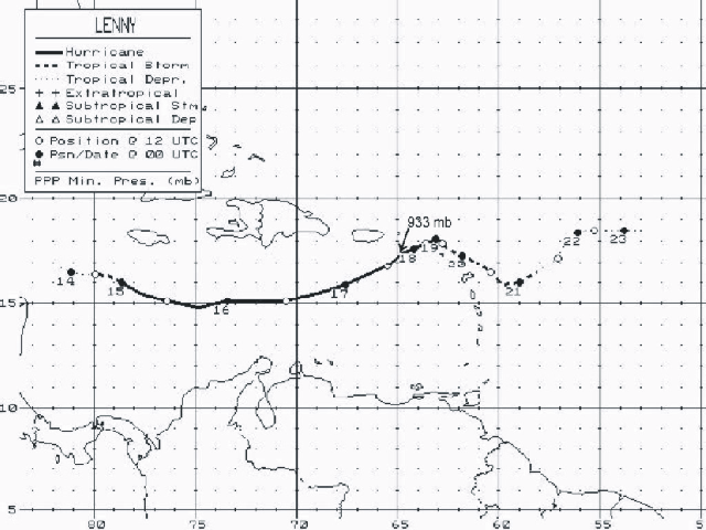