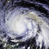
All Topics  
Hurricane Gloria

 
Hurricane Gloria

   Email Print
   Bookmark   Link


Hurricane Gloria


Hurricane Gloria was a powerful Cape Verde-type
Cape Verde-type hurricane

A Cape Verde-type hurricane is an Atlantic hurricane that develops near the Cape Verde islands, off the west coast of Africa. The average hurricane season has about two Cape Verde-type hurricanes, which are usually the most intense storms of the season because they often have plenty of warm open ocean over which to develop before encounterin...
 hurricane that formed during the 1985 Atlantic hurricane season
1985 Atlantic hurricane season

The 1985 Atlantic hurricane season officially began on June 1, 1985, and lasted until November 30, 1985. These dates conventionally delimit the period of each year when most tropical cyclones form in the Atlantic basin....
 and prowled the Atlantic Ocean
Atlantic Ocean

The Atlantic Ocean is the second-largest of the world's oceanic divisions; with a total area of about 106.4 million square kilometres . It covers approximately one-fifth of the Earth's surface....
 from September 16 to September 28. Gloria reached Category 4 status on the Saffir-Simpson Hurricane Scale
Saffir-Simpson Hurricane Scale

The Saffir-Simpson Hurricane Scale is a classification used for most Western Hemisphere tropical cyclones that exceed the intensities of tropical depressions and tropical storms, and thereby become hurricanes....
 near the Bahamas, but weakened significantly by the time it made landfall on North Carolina
North Carolina

North Carolina is a U.S. state located on the Atlantic Seaboard in the southeastern United States. The state borders South Carolina and Georgia to the south, Tennessee to the west and Virginia to the north....
's Outer Banks
Outer Banks

The Outer Banks is a 200-mile long string of narrow barrier islands off the coast of North Carolina, beginning in southeastern corner of Virginia Beach on the east coast of the United States....
. Gloria closely followed the Mid-Atlantic
Mid-Atlantic States

The Mid-Atlantic States form one of the nine geographic divisions within the United States that are officially recognized by the United States Census Bureau....
 coastline and made a second landfall on Long Island
Long Island

Long Island is an island located in southeastern New York, United States, just east of Manhattan. Stretching northeast into the Atlantic Ocean, Long Island contains four counties, two of which are Borough s of New York City, and two of which are mainly suburban....
, and, after crossing the Long Island Sound
Long Island Sound

Long Island Sound is an estuary of the Atlantic Ocean and various rivers in the United States that lies between the coast of Connecticut to the north and Long Island, New York to the south....
, it made a third landfall in Connecticut
Connecticut

Connecticut is a U.S. state located in the New England region of the northeastern United States. The state borders New York to the west and south , Massachusetts to the north, and Rhode Island to the east....
.

Overall, the storm caused extensive damage along the East Coast of the United States
East Coast of the United States

The East Coast of the United States, also known as the "Eastern Seaboard" or "Atlantic Seaboard", refers to the easternmost coastal states in the central and northern United States, which touch the Atlantic Ocean and stretch up to Canada....
, amounting to $900 million ($ in today's terms), and was responsible for eight fatalities.


Discussion
Ask a question about 'Hurricane Gloria'
Start a new discussion about 'Hurricane Gloria'
Answer questions from other users
Full Discussion Forum


Encyclopedia


Hurricane Gloria was a powerful Cape Verde-type
Cape Verde-type hurricane

A Cape Verde-type hurricane is an Atlantic hurricane that develops near the Cape Verde islands, off the west coast of Africa. The average hurricane season has about two Cape Verde-type hurricanes, which are usually the most intense storms of the season because they often have plenty of warm open ocean over which to develop before encounterin...
 hurricane that formed during the 1985 Atlantic hurricane season
1985 Atlantic hurricane season

The 1985 Atlantic hurricane season officially began on June 1, 1985, and lasted until November 30, 1985. These dates conventionally delimit the period of each year when most tropical cyclones form in the Atlantic basin....
 and prowled the Atlantic Ocean
Atlantic Ocean

The Atlantic Ocean is the second-largest of the world's oceanic divisions; with a total area of about 106.4 million square kilometres . It covers approximately one-fifth of the Earth's surface....
 from September 16 to September 28. Gloria reached Category 4 status on the Saffir-Simpson Hurricane Scale
Saffir-Simpson Hurricane Scale

The Saffir-Simpson Hurricane Scale is a classification used for most Western Hemisphere tropical cyclones that exceed the intensities of tropical depressions and tropical storms, and thereby become hurricanes....
 near the Bahamas, but weakened significantly by the time it made landfall on North Carolina
North Carolina

North Carolina is a U.S. state located on the Atlantic Seaboard in the southeastern United States. The state borders South Carolina and Georgia to the south, Tennessee to the west and Virginia to the north....
's Outer Banks
Outer Banks

The Outer Banks is a 200-mile long string of narrow barrier islands off the coast of North Carolina, beginning in southeastern corner of Virginia Beach on the east coast of the United States....
. Gloria closely followed the Mid-Atlantic
Mid-Atlantic States

The Mid-Atlantic States form one of the nine geographic divisions within the United States that are officially recognized by the United States Census Bureau....
 coastline and made a second landfall on Long Island
Long Island

Long Island is an island located in southeastern New York, United States, just east of Manhattan. Stretching northeast into the Atlantic Ocean, Long Island contains four counties, two of which are Borough s of New York City, and two of which are mainly suburban....
, and, after crossing the Long Island Sound
Long Island Sound

Long Island Sound is an estuary of the Atlantic Ocean and various rivers in the United States that lies between the coast of Connecticut to the north and Long Island, New York to the south....
, it made a third landfall in Connecticut
Connecticut

Connecticut is a U.S. state located in the New England region of the northeastern United States. The state borders New York to the west and south , Massachusetts to the north, and Rhode Island to the east....
.

Overall, the storm caused extensive damage along the East Coast of the United States
East Coast of the United States

The East Coast of the United States, also known as the "Eastern Seaboard" or "Atlantic Seaboard", refers to the easternmost coastal states in the central and northern United States, which touch the Atlantic Ocean and stretch up to Canada....
, amounting to $900 million ($ in today's terms), and was responsible for eight fatalities. The storm was the first significant system to strike the northeastern United States
Northeastern United States

The Northeast is a region of the United States. According to the definition used by the United States Census Bureau, the Northeast region consists of nine states: Maine, New Hampshire, Vermont, Massachusetts, Rhode Island, Connecticut, New York, New Jersey, and Pennsylvania....
 since Hurricane Agnes
Hurricane Agnes

Hurricane Agnes was the first tropical storm and first hurricane of the 1972 Atlantic hurricane season. A rare June hurricane, it made landfall on the Florida Panhandle before moving northeastward and ravaging the Mid-Atlantic region as a tropical storm....
 in 1972
1972 Atlantic hurricane season

The 1972 Atlantic hurricane season officially began on June 1, 1972, and lasted until November 30, 1972. These dates conventionally delimit the period of each year when most tropical cyclones form in the Atlantic basin....
 and the first major storm to affect New York and Long Island directly since Hurricane Donna
Hurricane Donna

Hurricane Donna in the 1960 Atlantic hurricane season was a Cape Verde-type hurricane tropical cyclone which moved across the Leeward Islands, Puerto Rico, Hispanola, Cuba, The Bahamas, and every state on the East Coast of the United States....
 in 1960
1960 Atlantic hurricane season

The 1960 Atlantic hurricane season officially began on June 15, 1960, and lasted until November 15, 1960. These dates conventionally delimit the period of each year when most tropical cyclones form in the Atlantic basin....
. It was the last storm to hit the northeast until Hurricane Bob
Hurricane Bob

Hurricane Bob was the second named storm, first hurricane and first major hurricane of the 1991 Atlantic hurricane season. The only hurricane to make U.S....
 in 1991
1991 Atlantic hurricane season

The 1991 Atlantic hurricane season officially began on June 1, 1991, and lasted until November 30, 1991. These dates conventionally delimit the period of each year when most tropical cyclones form in the Atlantic basin....
.

Meteorological history

Gloria began as a tropical wave that moved off the coast of Africa on September 15. It moved westward through the favorable tropical Atlantic Ocean, and organized into a tropical depression the next day while south of the Cape Verde Islands. Tracking steadily west-northwestward due to the strong subtropical ridge, the depression continued to strengthen and became Tropical Storm Gloria on the 17th. Conditions for tropical development deteriorated, causing Gloria to weaken to a tropical depression on the 18th. After it crossed 45°W on the 20th, the system was able to restrengthen to a tropical storm, and steadily intensified as it approached the Lesser Antilles
Lesser Antilles

The Lesser Antilles, also known as the Caribbees, are part of the Antilles, which together with the Bahamas, the Turks and Caicos Islands, and Greater Antilles form the West Indies....
. While 620 miles (1000 km) east-southeast of St. Croix
Saint Croix, U.S. Virgin Islands

Saint Croix is an island in the Caribbean Sea, and a county and constituent Districts and sub-districts of the United States Virgin Islands of the United States Virgin Islands , an unincorporated territory of the United States....
, Gloria attained hurricane status.

Moving westward, Gloria threatened much of the Leeward Islands
Leeward Islands

The Leeward Islands are the northern islands of the Lesser Antilles chain of islands, part of the West Indies. They are situated where the Caribbean Sea meets the western Atlantic Ocean....
, prompting the islands' respective governments to issue Hurricane Warnings
Tropical cyclone warnings and watches

Warnings and watches are two levels of alert issued by national weather forecasting bodies to coastal areas threatened by the imminent approach of a tropical cyclone of tropical storm or hurricane intensity....
 in anticipation of the storm. A turn to the west-northwest occurred on September 22, and the hurricane passed 155 miles (250 km) to the north of Anegada
Anegada

Anegada is the northernmost of the British Virgin Islands, a group of islands which form part of the archipelago of the Virgin Islands. It lies approximately north of Virgin Gorda....
, the northernmost island in the Lesser Antilles
Lesser Antilles

The Lesser Antilles, also known as the Caribbees, are part of the Antilles, which together with the Bahamas, the Turks and Caicos Islands, and Greater Antilles form the West Indies....
. A break in the subtropical ridge, caused by Tropical Storms Fabian
1985 Atlantic hurricane season

The 1985 Atlantic hurricane season officially began on June 1, 1985, and lasted until November 30, 1985. These dates conventionally delimit the period of each year when most tropical cyclones form in the Atlantic basin....
 and Henri
1985 Atlantic hurricane season

The 1985 Atlantic hurricane season officially began on June 1, 1985, and lasted until November 30, 1985. These dates conventionally delimit the period of each year when most tropical cyclones form in the Atlantic basin....
, was responsible for the northward turn and caused Gloria to take a northwest track. While passing to the northeast of the Bahamas, Gloria strengthened significantly in very favorable conditions, reaching major hurricane status on the 24th and peak wind speeds of 145 mph (235 km/h) and a central pressure of 919 mbar
Bar (unit)

The bar , decibar and the millibar are units of pressure. They are not SI units, nor are they cgs units, but they are accepted for use with the SI....
 on the 25th. This is the second lowest pressure ever recorded in an Atlantic hurricane
Atlantic hurricane

North Atlantic tropical cyclones usually form in summer or autumn. Tropical cyclones can be broken down by intensity. Tropical storms have one-minute maximum sustained winds of at least 39 mph , while hurricanes have one-minute maximum sustained exceeding 74 mph ....
 that never reached Category 5
Saffir-Simpson Hurricane Scale

The Saffir-Simpson Hurricane Scale is a classification used for most Western Hemisphere tropical cyclones that exceed the intensities of tropical depressions and tropical storms, and thereby become hurricanes....
 status, only second to Hurricane Opal
Hurricane Opal

Hurricane Opal was a major tropical cyclone that formed in the Gulf of Mexico in September 1995.Opal was the 9th hurricane of the abnormally active 1995 Atlantic hurricane season....
 of the 1995 season
1995 Atlantic hurricane season

The 1995 Atlantic hurricane season officially began on June 1, 1995, and lasted until November 30, 1995. These dates conventionally delimit the period of each year when most tropical cyclones form in the Atlantic basin....
.

Hurricane Gloria South of North Carolina
Shortly after peaking, Gloria's asymmetrical wind field caused the storm to rapidly weaken, and its winds decreased to 90 mph (145 km/h) after 18 hours. Continuing around the periphery of the subtropical ridge, the hurricane turned to the north-northeast, and its winds strengthened to 105 mph (170 km/h) as it passed over the warm waters of the Gulf Stream
Gulf Stream

The Gulf Stream, together with its northern extension towards Europe, the North Atlantic Current, is a powerful, warm, and swift Atlantic Ocean ocean current that originates in the Gulf of Mexico, exits through the Straits of Florida, and follows the eastern coastlines of the United States and Newfoundland and Labrador before crossing the At...
. Gloria then struck Cape Hatteras, North Carolina early on September 26, with winds of 105 mph (170 km/h) and a pressure of 942 mbar
Bar (unit)

The bar , decibar and the millibar are units of pressure. They are not SI units, nor are they cgs units, but they are accepted for use with the SI....
 while accelerating to the northeast. Gloria became the strongest recorded hurricane to strike the U.S. East Coast so far north, a distinction it still holds. It paralleled the coastlines of Virginia
Virginia

The Commonwealth of Virginia is an United States U.S. state on the East Coast of the United States of the Southern United States. The state is known as the "Old Dominion" and sometimes as "Mother of Presidents", because it is the birthplace of Lists of United States Presidents by place of birth#By state....
, Maryland
Maryland

Maryland is a U.S. state located in the Mid Atlantic States of the United States, bordering Virginia, West Virginia and the Washington, D.C. to the south and west, Pennsylvania to the north, and Delaware to the east....
, Delaware
Delaware

Delaware is a U.S. state located on the East Coast of the United States in the Mid-Atlantic States region of the United States. The state takes its name from Thomas West, 3rd Baron De La Warr, a British nobleman and Virginia's first colonial governor, after whom Cape Henlopen was originally named....
, and New Jersey
New Jersey

New Jersey is a state in the Mid-Atlantic States and Northeastern United States regions of the United States. It is bordered on the north by New York, on the east by the Hudson River and the Atlantic Ocean, on the southwest by Delaware, and on the west by Pennsylvania....
, coming within miles of land.

Gloria made its final landfall on western Long Island
Long Island

Long Island is an island located in southeastern New York, United States, just east of Manhattan. Stretching northeast into the Atlantic Ocean, Long Island contains four counties, two of which are Borough s of New York City, and two of which are mainly suburban....
 near Long Beach, New York
Long Beach, New York

Long Beach is a Political subdivisions of New York State#City in Nassau County, New York, New York on a barrier island off the South Shore of Long Island and one of only two cities in the county....
 as a weaker yet still strong hurricane just 10 hours after hitting the Outer Banks. Originally, the National Hurricane Center classified Gloria as a major hurricane upon making landfall but it was later downgraded in the seasonal post-analysis. Even so, the hurricane did produce Category Three wind gusts throughout Long Island. Shortly thereafter the storm crossed the Connecticut
Connecticut

Connecticut is a U.S. state located in the New England region of the northeastern United States. The state borders New York to the west and south , Massachusetts to the north, and Rhode Island to the east....
 coastline near Bridgeport
Bridgeport, Connecticut

Bridgeport is the most populous city in the U.S. state of Connecticut. Located in and the former county seat of Fairfield County, Connecticut, the city had an estimated population of 137,912 in 2006 and is the core of the Greater Bridgeport area....
, and while continuing northeastward through New England
New England

New England is a region of the United States located in the northeastern corner of the country, bounded by the Atlantic Ocean, Canada and New York State, and consisting of the modern U.S....
, it became extratropical over Maine
Maine

The State of Maine is a U.S. state in the New England region of the northeastern United States of America, bordering the Atlantic Ocean to the southeast, New Hampshire to the southwest, the Canadian provinces of Quebec to the northwest and New Brunswick to the northeast....
 early on the 28th. After moving through Atlantic Canada
Atlantic Canada

File:Atlantic Canada.svgAtlantic Canada, also known as the Atlantic provinces, is the List of regions of Canada of Canada comprising four Provinces and territories of Canada located on the Atlantic Ocean: the three Maritimes ? New Brunswick, Nova Scotia, and Prince Edward Island ? and Newfoundland and Labrador....
, the extratropical storm tracked eastward before dissipating on October 2 to the southwest of Iceland
Iceland

Iceland, officially the Republic of Iceland , is an island country located in the North Atlantic Ocean between mainland Europe and Greenland....
.

Preparations

Hurricane Gloria1985
As Gloria approached the East Coast of the United States
East Coast of the United States

The East Coast of the United States, also known as the "Eastern Seaboard" or "Atlantic Seaboard", refers to the easternmost coastal states in the central and northern United States, which touch the Atlantic Ocean and stretch up to Canada....
, National Hurricane Center
National Hurricane Center

The National Hurricane Center , located at Florida International University in Miami, Florida, is the division of National Weather Service's Tropical Prediction Center responsible for tracking and predicting the likely behavior of tropical depressions, tropical storms and tropical cyclone....
 director Neil Frank
Neil Frank

Dr. Neil Frank, Ph.D. is an United States meteorologist and former director of the National Hurricane Center in Florida. He was instrumental in advancing both the scientific and informational aspects of hurricane forecasting....
 called it the "Storm of the Century", due to its intensity and potential track over the densely populated region of New England
New England

New England is a region of the United States located in the northeastern corner of the country, bounded by the Atlantic Ocean, Canada and New York State, and consisting of the modern U.S....
. Such a track gathered the attention of many people, and led to the evacuation of 380,000 people along the coast from North Carolina to Connecticut. In Maryland
Maryland

Maryland is a U.S. state located in the Mid Atlantic States of the United States, bordering Virginia, West Virginia and the Washington, D.C. to the south and west, Pennsylvania to the north, and Delaware to the east....
, officials implemented lane reversing
Contraflow lane reversal

Contraflow lane reversal is used to refer to plans that alter the normal flow of traffic, typically on a controlled-access highway such as a freeway or motorway, to either aid in an emergency evacuation or, as part of routine maintenance activities, to facilitate widening or reconstruction of one of the highway's carriageways ....
 to expedite the evacuation process, a policy many other coastal states use.

Officials advised 95,000 citizens along the New Jersey
New Jersey

New Jersey is a state in the Mid-Atlantic States and Northeastern United States regions of the United States. It is bordered on the north by New York, on the east by the Hudson River and the Atlantic Ocean, on the southwest by Delaware, and on the west by Pennsylvania....
 coastline, an area that rarely experiences hurricanes, to evacuate. Cape May County—the most vulnerable part of the state and among the most susceptible in the entire country—would require 36 hours in 2005 to evacuate the 100,000 citizens and 900,000 tourists that were commonly present during busy summer weekends. In 1985, 397 unofficial shelters existed in the county for the preparation of Hurricane Gloria, of which one 150 were located on boardwalks; if the hurricane were to strike, only a small area in the northwest part of the county would be safe from the storm surge. Due to its vulnerability, an evacuation of the entire county would be required to avoid significant human losses in future hurricanes.

Offices and classes of Harvard University
Harvard University

Harvard University is a private university in Cambridge, Massachusetts, Massachusetts, United States, and a member of the Ivy League. Founded in 1636 by the colonial Massachusetts legislature, Harvard is the Colonial Colleges institution of higher learning in the United States....
 closed only for the third time in the 20th century, the previous cases being the New England Hurricane of 1938
New England Hurricane of 1938

The New England Hurricane of 1938 was the first major hurricane to strike New England since 1869. The storm formed near the coast of Africa in September of the 1938 Atlantic hurricane season, becoming a Category 5 hurricane on the Saffir-Simpson Hurricane Scale before making landfall as a Category 3 hurricane on Long Island on Sep...
 and the Blizzard of '78
Northeastern United States Blizzard of 1978

The Northeastern United States blizzard of 1978 was a severe nor'easter that brought blizzard conditions to the New England region of the United States and the New York metropolitan area....
. Although Gloria's winds downed numerous trees and caused tens of thousands in damage in the area, overall effects were much less than expected.

Impact

H52 Hurricane Gloria 1985
Hurricane Gloria was a large hurricane that affected much of the northeastern United States
Northeastern United States

The Northeast is a region of the United States. According to the definition used by the United States Census Bureau, the Northeast region consists of nine states: Maine, New Hampshire, Vermont, Massachusetts, Rhode Island, Connecticut, New York, New Jersey, and Pennsylvania....
. Gloria brought strong wind gusts to the area, downing thousands of trees and leaving over two million people without power. Overall, Gloria caused $900 million (1985 USD
United States dollar

The United States dollar is the unit of currency of the United States and was defined by the Coinage Act of 1792 to be between 371 and 416 grains of silver ....
) in property damage and eight deaths, a total lower than expected due to the hurricane's arrival at low tide.

Carolinas and Mid-Atlantic

Upon making landfall on the Outer Banks
Outer Banks

The Outer Banks is a 200-mile long string of narrow barrier islands off the coast of North Carolina, beginning in southeastern corner of Virginia Beach on the east coast of the United States....
, Gloria was a fast-moving hurricane that struck at low tide, reducing storm surge
Storm surge

Storm surge is an offshore rise of water associated with a low pressure area weather system, typically a tropical cyclone. Storm surge is caused primarily by high winds pushing on the ocean's surface....
s to a maximum of 6 ft (1.8 m) in North Carolina
North Carolina

North Carolina is a U.S. state located on the Atlantic Seaboard in the southeastern United States. The state borders South Carolina and Georgia to the south, Tennessee to the west and Virginia to the north....
. Other locations from South Carolina
South Carolina

South Carolina is a U.S. state in the Southern United States of the United States. It borders Georgia to the south and North Carolina to the north....
 through New Jersey
New Jersey

New Jersey is a state in the Mid-Atlantic States and Northeastern United States regions of the United States. It is bordered on the north by New York, on the east by the Hudson River and the Atlantic Ocean, on the southwest by Delaware, and on the west by Pennsylvania....
 reported surges less than 1–5 feet (0.3–1.5 m) high. Similarly, winds were relatively minimal and confined to the coast. Diamond Shoal Light
Diamond Shoal Light

Diamond Shoal Light was an offshore lighthouse marking Diamond Shoals off of Cape Hatteras....
 reported sustained winds of 100 mph (160 km/h), and Cape Hatteras
Cape Hatteras

Cape Hatteras is a Headlands and bays on the coast of North Carolina. It is the point that protrudes the farthest to the southeast along the northeast-to-southwest line of the Atlantic Ocean coast of North America....
, where the storm's eye came ashore, experienced 75 mph (120 km/h) winds. Much of the Mid-Atlantic
Mid-Atlantic States

The Mid-Atlantic States form one of the nine geographic divisions within the United States that are officially recognized by the United States Census Bureau....
 coastline was largely unscathed from Gloria's winds, excluding a report of 90 mph (145 km/h) on the Chesapeake Bay Bridge-Tunnel
Chesapeake Bay Bridge-Tunnel

The Chesapeake Bay Bridge-Tunnel is a 23-mile long fixed link that connects the Delmarva Peninsula with southeastern Virginia in the United States....
 and a report of 80 mph (130 km/h) in Ocean City, New Jersey
Ocean City, New Jersey

File:Ocean City NJ boardwalk looking south from 12th Street.JPGOcean City is a City in Atlantic County, New Jersey, New Jersey, United States....
. Though Gloria moved quickly through the region, it dropped moderate rainfall in locations, including peaks of 7.09 inches (180 mm) in New Bern, North Carolina
New Bern, North Carolina

New Bern is a city in Craven County, North Carolina, North Carolina with a population of 23,128 as of the 2000 census. The estimated population in 2006 was 27,650....
 and 6.04 inches (153 mm) at Baltimore-Washington International Airport
Baltimore-Washington International Thurgood Marshall Airport

Baltimore/Washington International Thurgood Marshall Airport serves the Baltimore-Washington Metropolitan Area . It is commonly called BWI or BWI Airport, its IATA Airport Code, an initialism for "Baltimore/Washington International," or as BWI-Marshall....
. In addition, some unofficial reports in southeastern Virginia
Virginia

The Commonwealth of Virginia is an United States U.S. state on the East Coast of the United States of the Southern United States. The state is known as the "Old Dominion" and sometimes as "Mother of Presidents", because it is the birthplace of Lists of United States Presidents by place of birth#By state....
 indicated amounts of up to 8 inches (200 mm) of rain.

Because much of the Mid-Atlantic experienced the western, weaker side of this hurricane, damage was relatively light. High winds downed numerous trees throughout the area, leaving hundreds of thousands without power, including 237,000 in New Jersey, 124,000 in Maryland, and 56,000 in Virginia. Extreme rainfall in Virginia
Virginia

The Commonwealth of Virginia is an United States U.S. state on the East Coast of the United States of the Southern United States. The state is known as the "Old Dominion" and sometimes as "Mother of Presidents", because it is the birthplace of Lists of United States Presidents by place of birth#By state....
 resulted in $5.5 million (1985 USD, $9.8 million 2005 USD) in damage. Intense flood waters split Long Beach Island
Long Beach Island

Long Beach Island is a Bar and summer colony along the Atlantic Ocean coast of Ocean County, New Jersey, New Jersey in the United States. Aligned north-south, the northern portion is generally slightly higher end, low-density residential; whereas the southern portion possesses more economical, higher-density housing and considerable comm...
 in half for a period of time. The hurricane's winds caused significant beach erosion, the area most affected being the Outer Banks.

Long Island and New York

Sunday Newsday Sept
Though Gloria hit Long Island
Long Island

Long Island is an island located in southeastern New York, United States, just east of Manhattan. Stretching northeast into the Atlantic Ocean, Long Island contains four counties, two of which are Borough s of New York City, and two of which are mainly suburban....
 with winds of 95 to 100 mph (135 km/h), wind gusts reached up to 115 mph (185 km/h) in eastern Long Island
Long Island

Long Island is an island located in southeastern New York, United States, just east of Manhattan. Stretching northeast into the Atlantic Ocean, Long Island contains four counties, two of which are Borough s of New York City, and two of which are mainly suburban....
. Islip, New York
Islip (town), New York

The Political subdivisions of New York State#Town of Islip is located in southern Suffolk County, New York, New York on the south shore of Long Island....
 recorded a wind gust of 85 mph (135 km/h). However, few other wind reports were available from the island as Gloria winds knocked out weather instruments. Weather forecasters believe that damage across parts of Long Island indicated winds in the Category Three range, as evidence of the damaged received at MacArthur Airport. Because the hurricane arrived at low tide, storm surges were generally low, peaking at 6.9 feet (2.1 m) at Battery Park
Battery Park (New York)

Battery Park is a 25-acre public park located at the Battery, the southern tip of the New York City borough of Manhattan, facing New York Harbor....
. Because it moved quickly, Gloria failed to produce significant rainfall amounts, and caused only 3.4 inches (86 mm) of rain in Central Park
Central Park

Central Park is a large public, urban park in New York City, with about twenty-five million visitors annually. Most of the areas immediately adjacent to the park are known for impressive buildings and valuable real estate....
.

Gloria's high winds caused significant damage across Long Island and southeastern New York. The area hit the worst was eastern Long Island, where high wind gusts blew thousands of trees into buildings and across roads. In addition, the winds ripped roofs off of many buildings, including hangars at the MacArthur Airport and the roof of the Islip Police Station. Prolonged exposure to high winds and waves led to moderate beach erosion, washing away several piers and docks. The storm surge, though relatively weak, destroyed 48 houses on the ocean side of the island. Gloria's high winds left 683,000 people in New York without power, with some lacking electricity for over eleven days. Even though damage amounted to $300 million ($532 million in 2005 USD), due to well-executed evacuations there was only one casualty, the death occurring from a falling tree.

New England and Canada

Upon making landfall in Milford, Connecticut
Milford, Connecticut

Milford is a city in southwestern New Haven County, Connecticut, Connecticut, United States; that is located between Bridgeport, Connecticut and New Haven, Connecticut....
, Gloria was a weakened hurricane that passed quickly through the area. Though still a large hurricane, Gloria hit at low tide, resulting in low to moderate storm surges of 5 feet (1.5 m) in Groton, Connecticut
Groton, Connecticut

Groton is a New England town located on the Thames River in New London County, Connecticut, Connecticut, United States. The population was 39,907 at the 2000 United States Census....
, 6 feet (1.8 m) in New Bedford, Massachusetts
New Bedford, Massachusetts

New Bedford is a city in Bristol County, Massachusetts, Massachusetts, United States, located about 51 miles south of Boston, Massachusetts, 28 miles southeast of Providence, Rhode Island, Rhode Island, and about 12 miles east of Fall River, Massachusetts....
, and 1 foot (.3 m) in Portland, Maine
Portland, Maine

Portland is the largest city in the U.S. state of Maine and the county seat of Cumberland County, Maine. The city population was 64,249 at the 2000 United States Census....
. The hurricane produced gusty winds across New England
New England

New England is a region of the United States located in the northeastern corner of the country, bounded by the Atlantic Ocean, Canada and New York State, and consisting of the modern U.S....
, with a peak observation of 83 mph (135 km/h) in Waterbury, Connecticut
Waterbury, Connecticut

Waterbury is a city in New Haven County, Connecticut, Connecticut, on the Naugatuck River Valley, 33 miles southwest of Hartford, Connecticut....
 and Blue Hill Meteorological Observatory
Blue Hill Meteorological Observatory

The Blue Hill Meteorological Observatory, or the Great Blue Hill Weather Observatory or Blue Hill Weather Observatory, in Milton, Massachusetts is the foremost structure associated with the history of weather observations in the United States....
 in Massachusetts. Gloria dropped moderate precipitation in the area amounting to a maximum of 6 inches (150 mm) in Littleville Lake, Massachusetts. In addition, Gloria caused significant beach erosion in Connecticut and Rhode Island
Rhode Island

Rhode Island and Providence Plantations, more commonly referred to as Rhode Island , is a U.S. state in the New England region of the United States....
.

Gloria Rainfall
Gloria's high winds downed numerous trees across New England, causing minor to moderate damage. In the region, Connecticut received the worst of the hurricane, where tree and structural damage was greatest. Along the coastline, storm surge and strong waves washed away several fishing piers, and some roadways were underwater during the storm's passage. The hurricane did not pass close enough to Rhode Island
Rhode Island

Rhode Island and Providence Plantations, more commonly referred to as Rhode Island , is a U.S. state in the New England region of the United States....
 and parts of Massachusetts
Massachusetts

The Commonwealth of Massachusetts is a U.S. state located in the New England region of the Northeastern United States United States. It borders Rhode Island and Connecticut to the south, New York to the west, and Vermont and New Hampshire to the north....
, so these areas did not receive significant damage. New Hampshire
New Hampshire

New Hampshire is a U.S. state in the New England region of the Northeastern United States United States of America. The state was named after the southern English Counties of England of Hampshire....
 was affected only slightly from the hurricane, and was limited to minor wind damage and localized flooding. In Maine
Maine

The State of Maine is a U.S. state in the New England region of the northeastern United States of America, bordering the Atlantic Ocean to the southeast, New Hampshire to the southwest, the Canadian provinces of Quebec to the northwest and New Brunswick to the northeast....
, damage was more severe, where strong wind gusts ripped off roofs and uprooted hundreds of trees. High winds across New England resulted in significant power outages, leaving 250,000 in Maine, 84,000 in Massachusetts, 174,000 in Rhode Island, and 669,000 in Connecticut without power. In all, 7 deaths occurred in New England, many of which occurred from falling tree limbs.

The extratropical remnants caused minimal damage in Nova Scotia
Nova Scotia

Nova Scotia is a Canadian Provinces and territories of Canada located on Canada's southeastern coast. It is the most populous province in Atlantic Canada....
 and produced tropical storm force winds across southern Newfoundland.

Aftermath

In the immediate aftermath in New York, hundreds of thousands had great difficulty living their everyday lives without power. The long duration without electricity led to a general disdain for the Long Island Lighting Company
Long Island Lighting Company

The Long Island Lighting Company, or LILCo [ "lil-co" ], was an Electrical power industry and natural gas utility for the communities of Long Island, New York, serving 2.7 million people in Nassau County, New York, Suffolk County, New York and Queens County, New York Counties....
. This increased further when the company left the $40 million (1985 USD) repair bill to the ratepayers, citing the company didn't have hurricane insurance. Citizens quickly protested this privately owned company, and within years the publicly owned Long Island Power Authority
Long Island Power Authority

The Long Island Power Authority or LIPA [ "lie-pah" ], a municipal subdivision of the State of New York, was created under the Long Island Power Act of 1985 to acquire the Long Island Lighting Company 's assets and securities....
 was formed.

In Maine, most citizens remained indoors during the passage of the hurricane. One police officer noted that even the criminals stayed home. In the Lewiston
Lewiston, Maine

Lewiston is a city in Androscoggin County, Maine in the U.S. state of Maine and the second-largest city in the state. The population was 35,690 at the United States Census, 2000....
 area, restaurants experienced a great surge in business. During the power outage after the storm, several businesses stored frozen goods for houses without a generator. After the storm, President Ronald Reagan
Ronald Reagan

Ronald Wilson Reagan was the List of Presidents of the United States President of the United States and the 33rd Governor of California . Born in Illinois, Reagan moved to Los Angeles, California in the 1930s, where he was an actor, president of the Screen Actors Guild , and a spokesman for General Electric ....
 declared several counties in New Jersey, Pennsylvania, New York, Rhode Island, Connecticut, and Massachusetts as federal disaster areas. This declaration allowed those counties to apply for disaster assistance.

Hurricane Gloria's less-than-expected damage prompted Environment Canada
Environment Canada

Environment Canada , legally incorporated as the Department of the Environment under the Department of the Environment Act , is the Ministry of the Government of Canada with responsibility for coordinating environmental policies and programs as well as preserving and enhancing the natural environment and conservation of wildlife....
 to create the Canadian Hurricane Centre
Canadian Hurricane Centre

The Canadian Hurricane Centre is a division of the Meteorological Service of Canada, an agency of Canada's Environment Canada, which exists to advise Canadians on the threat of tropical cyclones such as hurricanes and tropical storms....
. Due to its impact, the name Gloria was retired from the Atlantic tropical storm name list in the spring of 1986, so it will never again be used for an Atlantic hurricane
Atlantic hurricane

North Atlantic tropical cyclones usually form in summer or autumn. Tropical cyclones can be broken down by intensity. Tropical storms have one-minute maximum sustained winds of at least 39 mph , while hurricanes have one-minute maximum sustained exceeding 74 mph ....
. It was replaced with Grace in the 1991 season
1991 Atlantic hurricane season

The 1991 Atlantic hurricane season officially began on June 1, 1991, and lasted until November 30, 1991. These dates conventionally delimit the period of each year when most tropical cyclones form in the Atlantic basin....
.

See also

  • List of Atlantic hurricanes
  • List of retired Atlantic hurricane names
  • List of wettest tropical cyclones in Massachusetts
    List of wettest tropical cyclones in the United States

    This list of wettest tropical cyclones in the United States presents the highest known rainfall totals from tropical cyclones and their remnants....
  • List of New York hurricanes
    List of New York hurricanes

    List of New York hurricanes encompasses 84 tropical or subtropical cyclones that have affected the state of New York State since the 17th century....
  • List of New Jersey hurricanes
    List of New Jersey hurricanes

    A New Jersey hurricane is a tropical cyclone originating in the Atlantic Ocean that affects the state of New Jersey. Though some tropical cyclones have affected the state, it should be a low concern for New Jersey residents....
  • List of North Carolina hurricanes
    List of North Carolina hurricanes

    The list of North Carolina hurricanes includes 400 known tropical cyclone or subtropical cyclones that have affected the U.S. state of North Carolina....


External links

Buchholz, Margaret and Savadove, Larry (1993). Great Storms of the Jersey Shore. Down the Shore Publishing. ISBN 0-945582-51-X.