
Hurricane Opal
Encyclopedia
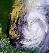
Hurricane Opal was a Category 4 hurricane
that formed in the Gulf of Mexico
in September 1995.
Opal was the ninth hurricane and the strongest of the abnormally active 1995 Atlantic hurricane season
. It crossed the Yucatán Peninsula
while still a tropical depression from September 27, then strengthened northward in the Gulf, becoming the most powerful Category 4 Atlantic hurricane before making a second landfall, October 4, in the Florida Panhandle
near Pensacola
as a 115-mph (185-km/h) hurricane. Opal devastated the Pensacola
/Panhandle area with a 15-ft (5-m) storm surge and travelled up the entire state of Alabama
, becoming a tropical storm in Tennessee
. Opal also caused heavy damage in the mid-Atlantic states before dissipating.
Afterward, 50 people had died from flooding by Opal in Guatemala
and Mexico
, with another 13 deaths in the United States directly or indirectly related to Opal. Preliminary damage estimates were $3 billion, the costliest so far in this season. The name "Opal" was retired in 1996, replaced by "Olga" for the 2001 season
.
(NHC) began monitoring a tropical wave
off the western coast of Africa. Tracking towards the west, the wave entered the Caribbean Sea
several days later before merging with a broad area of low pressure
in the western Caribbean sea on September 23. Weak steering currents around the low caused it to slowly drift towards the Yucatán Peninsula
while gradually becoming better organized. The system was classified as a tropical depression on September 27 while 70 nautical miles (129.6 km) south-southeast of Cozumel. The depression slowly moved over the Yucatán for the next several days, eventually emerging over the Bay of Campeche, where it was officially upgraded to Tropical Storm Opal.
After languishing for days and nearly dissipating due to the ocean-cooling effect of its own rainfall, it rapidly intensified to a hurricane and began moving north across the Gulf of Mexico. It deepened to a Category 4 hurricane with sustained winds of 150 mph (241.4 km/h) and a central pressure of 916 mb (the lowest ever recorded in a hurricane that never reached Category 5 intensity), possibly due to crossing the Loop Current
.
 During this period of rapid strengthening, a small eye formed with a diameter of only about 6 miles (9.7 km). The hurricane then underwent an eyewall replacement cycle
to a 60-mile (97-km) eye, combined with increasing wind shear, causing the pressure to rise steadily over the next 8 hours to 940 mb as the maximum sustained winds diminished to 125 mph (201.2 km/h). Opal weakened still to 115 mph (185.1 km/h) before its final landfall in Santa Rosa Island, Florida
on October 4.
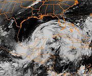
Opal remained a hurricane for nearly 12 hours after landfall, its rapid forward speed propelling it the entire length of Alabama before being downgraded to a tropical storm as it crossed into Tennessee. Over the following 12 hours, it was not downgraded to a tropical depression until it reached Ohio, and not declared extratropical until reaching Canada, where it still managed to bring squally conditions.
to just west of Pensacola, Florida
. A hurricane warning was issued for Mobile, Alabama
to Anclote Key, Florida on October 4. This one warning was extended from Mobile, Alabama westward to the mouth of the Mississippi River
including coastal Mississippi
. They were extended yet again for Grand Isle, Louisiana
westward to just east of Morgan City, Louisiana
including Metropolitan New Orleans. All remaining coastal watches and warnings were discontinued on October 5 at 0500 UTC.
The post-landfall watches and warnings released in accordance with Opal were a flash flood warning released on October 5 for portions of Alabama
, northern Georgia
, the western parts of North Carolina
and South Carolina
. The warning also included eastern Tennessee
. A flash flood watch was also in effect for portions of the Upper Ohio Valley, the Mid-Atlantic
region, the central Appalachians and the lower Great Lakes
. Wind warnings were in effect for northwestern South Carolina all the way to western New York
. A gale watch was also in effect for Lake Erie
, Lake Ontario
and the southern sections of the St. Lawrence Seaway.
Six hours later, the gale warnings over Lake Erie
, Lake Ontario
and the southern sections of the St. Lawrence Seaway were upgraded into a storm warning for Erie alone. The gale warning for the other two sections remained the same. The shoreline of Lake Erie was under a beach erosion warning from Buffalo, New York
to Ripley, New York
. The Storm Prediction Center released a tornado watch on northern and central New Jersey
, portions of New York
and Connecticut
on October 6.
Significant non-surge areas of Escambia County
south of US 98 were included in evacuation areas because of the potential for isolation by flooding.
, Campeche
, portions of Chiapas
, Quintana Roo
, and Yucatán
.
’s coastline felt effects from Hurricane Opal.
Rainfalls in Florida peaked at 15.45 inches (392.4 mm) in Ellyson, 7.27 inches (184.7 mm) at Pensacola, 6.64 inches (168.7 mm) at Hurlburt Field and lower in over eight different locations. The highest gust recorded was a 145 mi/h gust at Hurlburt Field. Lower gusts were 115 miles per hour (185.1 km/h) at Eglin Air Force Base
and an 88 mi/h gust at Pensacola P.N.S. The highest sustained winds were 84 mi/h at Hurlburt Field and 80 mi/h at Eglin Air Force Base
. The two reported storm surges were 5 feet (1.5 m) to 6 feet (1.8 m) above normal at Apalachicola
and 2 foot (0.6096 m) to 4 feet (1.2 m) above normal at Sarasota
. Opal brought heavy surge to the area, 8 feet (2.4 m) to 15 feet (4.6 m) in some areas, comparing itself to Hurricane Eloise
, which struck the same area at near equal strength in 1975
.
 Opal caused about US$3 billion (1995 dollars) in damage, making it the third costliest hurricane at the time. Most of the structural damage occurred near the coastline on the Florida Panhandle, due to intense surge. Amazingly enough, nearly a mile of U. S. Highway 98 near Eglin Air Force Base
was completely destroyed. The pavement was nearly replaced by mounds of sand left behind after storm surge. Opal also spawned an F2
tornado that killed a young woman in Florida. None died as a direct result of storm surge. This is quite unusual, considering the strength and landfall location of Opal. Okaloosa Island
, Fort Walton Beach, was overwhelmed by storm surge. Numerous homes were under 3 foot (0.9144 m) to 10 feet (3 m) of water. Residents were not allowed to return to the island until the homes could be secured from looters. A bus tour was arranged by the county so home owners could ‘see’ the damage, but the homeowners were not allowed off the bus. Looters were found crossing the bay on boats and surfboard, it was feared that some were armed. Sand dunes along the stretch of US-98, normally 25 feet (7.6 m) high, were removed by wind and surge. Where once the ocean was obscured from view by the dunes for miles, a flat open space opened up along U. S. Highway 98.
was 19.42 inches (493.3 mm) 3 miles (4.8 km) east-northeast of Brewton, Alabama
. Lesser amounts include 7.48 inches (190 mm) in Mobile and 6.1 inches (154.9 mm) in Anniston. The highest gust reported was a 95 mph (152.9 km/h) gust in Fort Rucker and a secondary one at Maxwell Air Force Base
with a gust of 90 mph (144.8 km/h). The highest sustained winds reported from Opal was 75 mph (120.7 km/h) at Fort Rucker, 55 mph (88.5 km/h) in downtown Mobile and 47 mph (75.6 km/h) at Maxwell Air Force Base
and Montgomery
.
Numerous downed trees across much of the southeastern United States left over 2 million without power. Alabama reported that 476,000 people were without power, which was a record at the time. This record number of power outages was beaten by Hurricane Ivan
in 2004. Damage was heavy all the way inland
to Montgomery
where winds reached 90 mph (144.8 km/h).
Highest rainfalls in Mississippi
were 5 inches (127 mm) throughout the eastern side of the state with lower amounts going westward. Tropical storm winds were reported along the Gulf Coast during the afternoon and early evening of October 4. Wind damage was mainly limited to downed tree limbs, power lines, and signs. Property damage cost estimated. One minor injury was reported in Harrison County due to flying debris. Damage in Mississippi totaled up to USD $75 thousand.
In Louisiana
, the only significant wind damage occurred in extreme south Plaquemines Parish where winds were estimated around 60 miles per hour (96.6 km/h) with gusts to hurricane force, with wind damage reported to some mobile homes and roofs of a few other structures. Tropical storm force winds, were reported in extreme south Lafourche Parish and Jefferson Parish, as well as extreme east St. Bernard Parish. Property damage cost estimated. Tides were generally 2 foot (0.6096 m) above normal in Lake Pontchartrain, and three to five feet above normal along the southeast Louisiana coast from Grand Isle
eastward. Some low-lying coastal roads were flooded.
Approximately 10,000 people evacuated from the southern, or lower portions, of Plaquemines, St. Bernard, Lafourche, and Jefferson Parishes. The only significant gathering of persons in public shelters occurred in Plaquemines Parish, where 1,600 people were placed in public shelters. Although no direct injuries occurred from the hurricane, an indirect injury is attributed to the hurricane in a freak accident. A Jefferson Parish employee was injured while attempting to lower a large flag on October 4. The employee, who was holding onto a rope attached a flag, was tossed high into the air, and suffered severe injuries when he fell back to the ground. Total damage in Louisiana totaled out to US$200,000 (1995 dollars).
Breaking swells from Opal in Texas
caused water to spill across at the usual wash-over points which damaged several vehicles.
was 8.66 inches (220 mm) in Marietta
, 8.08 inches (205.2 mm) in Peachtree City and 7.17 in (182 mm) in west Atlanta. Southern Georgia only reported 1–3 in (25.4–76.2 mm) of rain, while the northern part of the state reached about 5–7 in (127–177.8 mm). The peak wind gust in Georgia was a 79 mph (127 km/h) gust in Marietta, a 70 mph (113 km/h) gust in Columbus
, and a 56 mph (90 km/h) gust in the Atlanta-Hartsfield area. High winds in Rabun County
caused $5 million (1995 USD) from the approach of Opal on October 5. The damage was worst in Rabun County where numerous trees were blown down. The wind damage was described as being worse than the Superstorm of 1993. Power was out for some people for at least a week. More than 4000 trees were knocked down within the city of Atlanta alone. These trees fell across roads, and on power lines, homes, mobile homes, and automobiles. More than a half a dozen people were injured from falling trees in the early morning hours of October 5. There were more than 1200 telephone poles knocked down and almost 5,000 power lines snapped. Power crews from surrounding states helped to restore power to many, however, thousands of residences remained without power through the weekend.
An 80 foot (24 m) gash was torn out of Interstate 285
between Roswell Road and the Glenridge Connector in Atlanta. Schools were closed on October 5 and October 6 throughout the cities of Atlanta, Marietta, and in Fulton, Coweta, Carroll and Douglas counties. A total of 47 of 101 schools were closed in Dekalb County
alone. Four state parks were closed after Opal: Moccasin Creek Park, Black Rock Mountain, Vogel State Park
, and Fort Mountain State Park
. 273 stations reported many falling traffic lights. Agricultural experts estimated that damage to the pecan
crop was about USD $50.0 million. Several rivers and creeks overflowed their banks.
 Beginning the evening of October 4, numerous power outage
s were reported in metro Atlanta
, where sustained tropical storm conditions overnight (including gusts to nearly 70 mph (112.7 km/h) felled thousands of trees. Oak
s were particularly susceptible, as their root systems were loosened by nearly two days included in a major disaster area. Fourteen deaths were reported in Georgia alone.
Around 7 inches (177.8 mm) of rainfall was recorded in extreme northwestern South Carolina
and came in reducing amounts around the rest of the state. Heavy rainfalls closed roads and bridges, causing $24 million in crop and property damage. A tornado in Chesterfield, South Carolina caused many trees to be blown down in the Carolina Sandhills National Wildlife Refuge
. Trees were blown down in Orangeburg, one of those trees fell onto a car and totaled it. An F0 tornado spawned by one of Opal's bands downed a number of trees and power lines. Campers, vehicles, structures and boats were damaged in Greenville.
In North Carolina
, over 17 inches (431.8 mm) of rain fell. The rainfall included 9.89 inches (251.2 mm) in Robinson Creek and 8.95 inches (227.3 mm) in Highlands. The Robinson Creek rains spwaned flash flooding. Officials in the state had the citizens boil their water before drinking it because of a possibility that floodwater may have entered purification plants. A landslide triggered by Opal and damaged the Blue Ridge Parkway
. Opal triggered a debris flow in the Poplar Cove area of Macon County. A flash flood from rainfall amounts typically ranged from four to six inches (152 mm) and closed roads and bridges were the result. The most serious flooding apparently occurred in Avery County where evacuations were required and tanks of propane were found floating in the Banner Elk River.
Three deaths also occurred in the state. A man in Candler was killed when a falling tree destroyed his mobile home. Another man was killed near Marshall when a tree was blown onto him while he was helping cut other trees out of the roadway. 10 people were also injured by wind blown debris and from falling trees. Damage from high winds totaled up to $15 million.

, trees in the Shenandoah Valley and along the Allegheny Plateau were blown down by 40 mi/h winds at higher elevations. Over 7000 people were without power and damage in Virginia totaled to $5000. The National Park Service reported dozens of trees blown down along Skyline Drive in two counties.
In the Great Smoky Mountains
, power and phone service were out in many areas of the park. Newfound Gap
road closed for several days due to trees and a rockslide that were lying across it. Campers were asked to leave Elkmont Campground
near Gatlinburg because of high water.
Many sections of the Blue Ridge Parkway
were closed because of trees that fell across the road. Flooding occurred in the northern portion of the parkway. Linville Falls was evacuated; the Asheville and Gillespie Gap Districts were closed. Rockslides and mudslides had also been reported due to Opal.
In West Virginia
, 0.5–1.5 in (12.7–38.1 mm) of rain were reported causing some schools to let out early. High winds associated with the remnants of Opal moved through southeast West Virginia on the 5th. High winds ranged between 35 and 45 mi/h with some gusts to near 55 mi/h. A numerous amount of trees, large branches and power lines and ripped shingles off the roof of homes were ripped off in the wind. The vast majority of damage occurred at elevations above two thousand feet. Damage from the wind totaled out to $2000. Large limbs were downed by high wind across from the remnants of Hurricane Opal in Preston County. Damage there totaled out to $1000. Damage in West Virginia totaled out to only $5,000.
In Maryland
, a large tree and its limbs along Maryland Route 495
near Bittinger
were downed by high winds associated with the remnants of Opal. The damage from the fallen tree and its limbs totaled out to one thousand dollars. Mesocyclone
s moving around Opal's eastern periphery within Maryland spawned three tornadoes in Charles
, Prince George's
, and Anne Arundel County
. The first tornado tracked along State Route 425
between the towns of Ironside and Grayton. Along the tornado's path, several trees were uprooted or snapped; two sheds were destroyed and two others sustained roof damage. Windows were blown out of a barn and several vehicles. Ten thousand dollars in damage occurred. The second and strongest tornado hit ground in Temple Hills, injuring three people after reaching a peak wind of 150 mph (241.4 km/h). 100 homes were damaged with 15 being condemned. The Potomac Electric Power reported 9000 people without power. Damage from the second tornado totaled out to $5 million. The third and final tornado touched down in Odenton, became an F1 tornado and doing $250,000 in damage to the area. Eleven houses were damaged and about 10,000 people were without power in the whole district that the Baltimore Gas and Electric serves.
, rainfalls included about 3 to 5 in (76.2 to 127 mm) in the central part of the state, one inch (25 mm) at the western part of the state and 3 to 5 in (76.2 to 127 mm) in the eastern part of the state. Wind speeds at the higher elevations of the Appalachian Mountains were recorded at 70 mph (112.7 km/h) whereas 40–50 mph (64.4–80.5 km/h) gusts were more common at the lower elevations. Trees and power lines were down over much of the region. Over 70 miles (112.7 km) of the Appalachian Trail
were closed due to trees being down. A total of over 20,000 people were without power from Opal's wrath. The most damage occurred in Hamilton County
, which had damage was estimated over a total of $1 million. Damage in Hamilton County include a circus was left stranded at a campground and needed to be evacuated. A number of residences and businesses were also surrounded by water and occupants were to be evacuated. Total damage in Tennessee totaled out at USD $2.02 million.
In Kentucky
, 1 to 5 in (25.4 to 127 mm) of rain was reported throughout the state from Opal. Total rainfall across the county ranged from 2.4 inches (61 mm) at the Louisville International Airport to 3.5 inches (88.9 mm) at Fern Creek Road south of the Gene Snyder Freeway. Several trees were knocked down and soils were saturated after Opal passed through. A bridge washed out over Sulphur Creek and minor flooding was reported across Kentucky Route 80. Elizabethtown and the Fort Knox area had several roads closed after Opal washed them out.
In Michigan
, Opal produced 2 to 3 in (50.8 to 76.2 mm) of rain over the Middle Rouge River Basin from late afternoon through the evening on the 5th. As a result, the Middle Rouge River crested one foot over flood stage, causing the Edward Hines Drive to be closed off to traffic. High winds associated with the remains of Hurricane Opal affected the area during the late afternoon and early evening on the 5th. Strong northeast winds destroyed a new 200-foot (61-m), two-story pole barn on the Marine City Highway in Marine City
. The storm also cut power to several areas, resulting in some school closings. The maximum wind gust at Detroit Metro Airport was a 38-mph (61-km/h) gust, which was from the northeast. The damage from this incident totaled out to $15,000.
The remnants of Opal passed across northeast Ohio
and caused wind gusts up to 45 mph (72.4 km/h) and sustained winds of 20 to 30 mph (32.2 to 48.3 km/h) all across northern Ohio. Several automobiles were damaged by falling trees or limbs. Crops were damaged from the strong winds. A number of farms reported fields of corn blown over and ripe apples and other fruit being stripped from trees. Rain
fall of 3.4 inches (86.4 mm) in less than 24 hours was measured at Mansfield
, and most areas averaged 1.5 to 2.5 in (38.1 to 63.5 mm) during the same period. Flooding was localized and not significant since very dry conditions preceded the storm. Sustained northeast wind
s ahead of the storm reached 55 mph (88.5 km/h) all across the lake with gusts to 70 mph (112.7 km/h) producing wave
s of 10 to 14 ft (3 to 4.3 m). Minor to moderate beach and shore erosion occurred in many areas, especially the western end of the lake. Localized flooding occurred in communities with low lying areas along the lake. Boats were also grounded. Damage in Ohio totaled out to $205,000.
, thunderstorms with heavy rain, averaging around 3.5 inches (88.9 mm) countywide, caused flooding of small streams and roadways including United States Route 46. The heavy rain was represented as the first significant dent in the drought that had affected northern New Jersey since September 1994. Storm totals included 6.7 inches (170.2 mm) in Wawayanda, 5.3 (135 mm) in Hackettstown
, 4.5 inches (114.3 mm) in Oak Ridge
, 4.2 inches (106.7 mm) in Clinton
and 4.1 inches (104.1 mm) in Pequannock
.
The remnants of Opal caused severe thunderstorms that uprooted trees near Belvidere
. Trees and wires were down in scattered parts of the county including Route 57 near the Tri-county Firehouse. Downed wires caused power outages in Hackettstown
and Mansfield Township
.
The remnants of Hurricane Opal passed over northwest Pennsylvania
on Thursday night (5th/6th) and caused wind gusts up to 50 mph (80.5 km/h) and sustained winds of 20 to 30 mph (32.2 to 48.3 km/h). Heavy rains accompanied the storm and averaged 1.5 to 2.5 in (38.1 to 63.5 mm). Flooding was localized and not significant since drought conditions preceded the storm. The prolonged period of strong winds brought down trees and limbs along with some power lines. At least one automobile was damaged by a downed tree in Erie. Several farms reported fields of corn blown down and apples and other fruit being stripped from trees. The actual crop damage estimate was unknown.
The remnants of Opal passed just to the west of Buffalo
, New York
on October 5 and 6. Two to 3 inches (38–64 mm) of rain fell over much of the area with isolated amounts of near four inches (102 mm) over parts of the western Southern Tier. Sustained winds were estimated between 35 and 40 mph (56.3 and 64.4 km/h), but the easterly winds did down some trees and power lines. In Oneida County
, the high winds downed trees and wires in New York Mills, Waterville, Sylvan Beach, North Bay, Lee Center, Rome, McConnellsville and Verona. In Saratoga County
a large tree limb was downed in Saratoga Springs
which damaged four cars. Total damage in New York totaled to $35,000.
A low pressure area which used to be Opal moved across western and northern New York late and into Vermont
on the night of October 5 and the morning October 6. Damaging winds occurred across parts of central and northern Vermont but especially along the western slopes of the Green Mountains
. Damaging winds downed trees and power lines across Essex, Orleans, Addison, Caledonia and Rutland counties. In Essex County
damage occurred in Canaan and Concord. Damage was also reported in Caledonia County
, in Rutland County, in Clarendon and Chittenden and in Orleans County
in Derby Center. Total damage in Vermont totaled out to $135,000.
Heavy winds and rain associated with the remnants of Opal brought down trees and knocked out power in southwestern and northern New Hampshire
. One person was injured in Marlborough
when a large tree blew onto his moving pickup truck.
In Maine
, heavy winds and rain associated with the remnants of Opal brought down trees and knocked out power in coastal areas of southern Maine. Some beach erosion occurred in Saco
. Strong winds ripped away boats from their moorings in the Midcoast towns of Camden
and Rockland
.
and the upper St. Lawrence River in accordance with the remnants of Opal by the Canadian Hurricane Centre
on October 5. The remnants also spawned a heavy rainfall warning by the Ontario Hurricane Center and the Quebec Hurricane Center for both provinces. The anticipated rain would not exist as the same as Hurricane Hazel
41 years before. The leftover system of Opal spawned a gale warning for Nova Scotia
. Rainfalls equaled out to 0.5 inches (12.7 mm) in Northwestern Ontario
, 0.5 inches (12.7 mm) in southern parts of Quebec
and New Brunswick
. Rainfall stretched out to the area of Nova Scotia
, but only 0.5 inches (12.7 mm) was reported. Toronto had recorded winds of at least 52 mph (83.7 km/h) and rainfall of about 3.09 inches (78.5 mm).
, the name "Opal" was retired in the spring of 1996, and will never again be used in the Atlantic basin
. It was replaced with "Olga" in the 2001 season
.
Opal was the first storm to be assigned a name beginning with letter 'O' since hurricane naming began in the Atlantic
in 1950.
Tropical cyclone
A tropical cyclone is a storm system characterized by a large low-pressure center and numerous thunderstorms that produce strong winds and heavy rain. Tropical cyclones strengthen when water evaporated from the ocean is released as the saturated air rises, resulting in condensation of water vapor...
that formed in the Gulf of Mexico
Gulf of Mexico
The Gulf of Mexico is a partially landlocked ocean basin largely surrounded by the North American continent and the island of Cuba. It is bounded on the northeast, north and northwest by the Gulf Coast of the United States, on the southwest and south by Mexico, and on the southeast by Cuba. In...
in September 1995.
Opal was the ninth hurricane and the strongest of the abnormally active 1995 Atlantic hurricane season
1995 Atlantic hurricane season
The 1995 Atlantic hurricane season was the third most active Atlantic hurricane season on record. It officially began on June 1, 1995, and lasted until November 30, 1995. These dates conventionally delimit the period of each year when most tropical cyclones form in the north Atlantic ocean...
. It crossed the Yucatán Peninsula
Yucatán Peninsula
The Yucatán Peninsula, in southeastern Mexico, separates the Caribbean Sea from the Gulf of Mexico, with the northern coastline on the Yucatán Channel...
while still a tropical depression from September 27, then strengthened northward in the Gulf, becoming the most powerful Category 4 Atlantic hurricane before making a second landfall, October 4, in the Florida Panhandle
Florida Panhandle
The Florida Panhandle, an informal, unofficial term for the northwestern part of Florida, is a strip of land roughly 200 miles long and 50 to 100 miles wide , lying between Alabama on the north and the west, Georgia also on the north, and the Gulf of Mexico to the south. Its eastern boundary is...
near Pensacola
Pensacola, Florida
Pensacola is the westernmost city in the Florida Panhandle and the county seat of Escambia County, Florida, United States of America. As of the 2000 census, the city had a total population of 56,255 and as of 2009, the estimated population was 53,752...
as a 115-mph (185-km/h) hurricane. Opal devastated the Pensacola
Pensacola, Florida
Pensacola is the westernmost city in the Florida Panhandle and the county seat of Escambia County, Florida, United States of America. As of the 2000 census, the city had a total population of 56,255 and as of 2009, the estimated population was 53,752...
/Panhandle area with a 15-ft (5-m) storm surge and travelled up the entire state of Alabama
Alabama
Alabama is a state located in the southeastern region of the United States. It is bordered by Tennessee to the north, Georgia to the east, Florida and the Gulf of Mexico to the south, and Mississippi to the west. Alabama ranks 30th in total land area and ranks second in the size of its inland...
, becoming a tropical storm in Tennessee
Tennessee
Tennessee is a U.S. state located in the Southeastern United States. It has a population of 6,346,105, making it the nation's 17th-largest state by population, and covers , making it the 36th-largest by total land area...
. Opal also caused heavy damage in the mid-Atlantic states before dissipating.
Afterward, 50 people had died from flooding by Opal in Guatemala
Guatemala
Guatemala is a country in Central America bordered by Mexico to the north and west, the Pacific Ocean to the southwest, Belize to the northeast, the Caribbean to the east, and Honduras and El Salvador to the southeast...
and Mexico
Mexico
The United Mexican States , commonly known as Mexico , is a federal constitutional republic in North America. It is bordered on the north by the United States; on the south and west by the Pacific Ocean; on the southeast by Guatemala, Belize, and the Caribbean Sea; and on the east by the Gulf of...
, with another 13 deaths in the United States directly or indirectly related to Opal. Preliminary damage estimates were $3 billion, the costliest so far in this season. The name "Opal" was retired in 1996, replaced by "Olga" for the 2001 season
2001 Atlantic hurricane season
The 2001 Atlantic hurricane season was a fairly active Atlantic hurricane season that produced 17 tropical cyclones, 15 named storms, nine hurricanes, and four major hurricanes. The season officially lasted from June 1, 2001, to November 30, 2001, dates which by convention limit the period of each...
.
Meteorological history
On September 11, the National Hurricane CenterNational Hurricane Center
The National Hurricane Center , located at Florida International University in Miami, Florida, is the division of the National Weather Service responsible for tracking and predicting weather systems within the tropics between the Prime Meridian and the 140th meridian west poleward to the 30th...
(NHC) began monitoring a tropical wave
Tropical wave
Tropical waves, easterly waves, or tropical easterly waves, also known as African easterly waves in the Atlantic region, are a type of atmospheric trough, an elongated area of relatively low air pressure, oriented north to south, which move from east to west across the tropics causing areas of...
off the western coast of Africa. Tracking towards the west, the wave entered the Caribbean Sea
Caribbean Sea
The Caribbean Sea is a sea of the Atlantic Ocean located in the tropics of the Western hemisphere. It is bounded by Mexico and Central America to the west and southwest, to the north by the Greater Antilles, and to the east by the Lesser Antilles....
several days later before merging with a broad area of low pressure
Low pressure area
A low-pressure area, or "low", is a region where the atmospheric pressure at sea level is below that of surrounding locations. Low-pressure systems form under areas of wind divergence which occur in upper levels of the troposphere. The formation process of a low-pressure area is known as...
in the western Caribbean sea on September 23. Weak steering currents around the low caused it to slowly drift towards the Yucatán Peninsula
Yucatán Peninsula
The Yucatán Peninsula, in southeastern Mexico, separates the Caribbean Sea from the Gulf of Mexico, with the northern coastline on the Yucatán Channel...
while gradually becoming better organized. The system was classified as a tropical depression on September 27 while 70 nautical miles (129.6 km) south-southeast of Cozumel. The depression slowly moved over the Yucatán for the next several days, eventually emerging over the Bay of Campeche, where it was officially upgraded to Tropical Storm Opal.
After languishing for days and nearly dissipating due to the ocean-cooling effect of its own rainfall, it rapidly intensified to a hurricane and began moving north across the Gulf of Mexico. It deepened to a Category 4 hurricane with sustained winds of 150 mph (241.4 km/h) and a central pressure of 916 mb (the lowest ever recorded in a hurricane that never reached Category 5 intensity), possibly due to crossing the Loop Current
Loop Current
A parent to the Florida Current, the Loop Current is a warm ocean current in the Gulf of Mexico that flows northward between Cuba and the Yucatán peninsula, moves north into the Gulf of Mexico, loops east and south before exiting to the east through the Florida Straits and joining the Gulf Stream.A...
.
Eyewall replacement cycle
Eyewall replacement cycles, also called concentric eyewall cycles, naturally occur in intense tropical cyclones, generally with winds greater than 185 km/h , or major hurricanes...
to a 60-mile (97-km) eye, combined with increasing wind shear, causing the pressure to rise steadily over the next 8 hours to 940 mb as the maximum sustained winds diminished to 125 mph (201.2 km/h). Opal weakened still to 115 mph (185.1 km/h) before its final landfall in Santa Rosa Island, Florida
Santa Rosa Island, Florida
Santa Rosa Island[p] is a 40-mile barrier island located in the U.S. state of Florida, thirty miles east of the Alabama state border...
on October 4.
Opal remained a hurricane for nearly 12 hours after landfall, its rapid forward speed propelling it the entire length of Alabama before being downgraded to a tropical storm as it crossed into Tennessee. Over the following 12 hours, it was not downgraded to a tropical depression until it reached Ohio, and not declared extratropical until reaching Canada, where it still managed to bring squally conditions.
Preparations
Only four before-landfall watches and warnings were released in accordance with Hurricane Opal. The first was on September 30 for the northeast portion of the Yucatán Peninsula from Cozumel and Cancun to Progreso. This warning was discontinued late the next day. The second was a tropical storm warning issued on October 3 for Morgan City, LouisianaMorgan City, Louisiana
Morgan City is a city in St. Martin and St. Mary parishes in the U.S. state of Louisiana. The population was 12,404 at the 2010 census....
to just west of Pensacola, Florida
Pensacola, Florida
Pensacola is the westernmost city in the Florida Panhandle and the county seat of Escambia County, Florida, United States of America. As of the 2000 census, the city had a total population of 56,255 and as of 2009, the estimated population was 53,752...
. A hurricane warning was issued for Mobile, Alabama
Mobile, Alabama
Mobile is the third most populous city in the Southern US state of Alabama and is the county seat of Mobile County. It is located on the Mobile River and the central Gulf Coast of the United States. The population within the city limits was 195,111 during the 2010 census. It is the largest...
to Anclote Key, Florida on October 4. This one warning was extended from Mobile, Alabama westward to the mouth of the Mississippi River
Mississippi River
The Mississippi River is the largest river system in North America. Flowing entirely in the United States, this river rises in western Minnesota and meanders slowly southwards for to the Mississippi River Delta at the Gulf of Mexico. With its many tributaries, the Mississippi's watershed drains...
including coastal Mississippi
Mississippi
Mississippi is a U.S. state located in the Southern United States. Jackson is the state capital and largest city. The name of the state derives from the Mississippi River, which flows along its western boundary, whose name comes from the Ojibwe word misi-ziibi...
. They were extended yet again for Grand Isle, Louisiana
Grand Isle, Louisiana
Grand Isle is a town in Jefferson Parish, Louisiana, located on a barrier island of the same name in the Gulf of Mexico. The island is at the mouth of Barataria Bay where it meets the gulf. As of the 2000 census, the town population was 1,541; during summers, the population sometimes increases to...
westward to just east of Morgan City, Louisiana
Morgan City, Louisiana
Morgan City is a city in St. Martin and St. Mary parishes in the U.S. state of Louisiana. The population was 12,404 at the 2010 census....
including Metropolitan New Orleans. All remaining coastal watches and warnings were discontinued on October 5 at 0500 UTC.
The post-landfall watches and warnings released in accordance with Opal were a flash flood warning released on October 5 for portions of Alabama
Alabama
Alabama is a state located in the southeastern region of the United States. It is bordered by Tennessee to the north, Georgia to the east, Florida and the Gulf of Mexico to the south, and Mississippi to the west. Alabama ranks 30th in total land area and ranks second in the size of its inland...
, northern Georgia
Georgia (U.S. state)
Georgia is a state located in the southeastern United States. It was established in 1732, the last of the original Thirteen Colonies. The state is named after King George II of Great Britain. Georgia was the fourth state to ratify the United States Constitution, on January 2, 1788...
, the western parts of North Carolina
North Carolina
North Carolina is a state located in the southeastern United States. The state borders South Carolina and Georgia to the south, Tennessee to the west and Virginia to the north. North Carolina contains 100 counties. Its capital is Raleigh, and its largest city is Charlotte...
and South Carolina
South Carolina
South Carolina is a state in the Deep South of the United States that borders Georgia to the south, North Carolina to the north, and the Atlantic Ocean to the east. Originally part of the Province of Carolina, the Province of South Carolina was one of the 13 colonies that declared independence...
. The warning also included eastern Tennessee
Tennessee
Tennessee is a U.S. state located in the Southeastern United States. It has a population of 6,346,105, making it the nation's 17th-largest state by population, and covers , making it the 36th-largest by total land area...
. A flash flood watch was also in effect for portions of the Upper Ohio Valley, the Mid-Atlantic
Mid-Atlantic States
The Mid-Atlantic states, also called middle Atlantic states or simply the mid Atlantic, form a region of the United States generally located between New England and the South...
region, the central Appalachians and the lower Great Lakes
Great Lakes
The Great Lakes are a collection of freshwater lakes located in northeastern North America, on the Canada – United States border. Consisting of Lakes Superior, Michigan, Huron, Erie, and Ontario, they form the largest group of freshwater lakes on Earth by total surface, coming in second by volume...
. Wind warnings were in effect for northwestern South Carolina all the way to western New York
New York
New York is a state in the Northeastern region of the United States. It is the nation's third most populous state. New York is bordered by New Jersey and Pennsylvania to the south, and by Connecticut, Massachusetts and Vermont to the east...
. A gale watch was also in effect for Lake Erie
Lake Erie
Lake Erie is the fourth largest lake of the five Great Lakes in North America, and the tenth largest globally. It is the southernmost, shallowest, and smallest by volume of the Great Lakes and therefore also has the shortest average water residence time. It is bounded on the north by the...
, Lake Ontario
Lake Ontario
Lake Ontario is one of the five Great Lakes of North America. It is bounded on the north and southwest by the Canadian province of Ontario, and on the south by the American state of New York. Ontario, Canada's most populous province, was named for the lake. In the Wyandot language, ontarío means...
and the southern sections of the St. Lawrence Seaway.
Six hours later, the gale warnings over Lake Erie
Lake Erie
Lake Erie is the fourth largest lake of the five Great Lakes in North America, and the tenth largest globally. It is the southernmost, shallowest, and smallest by volume of the Great Lakes and therefore also has the shortest average water residence time. It is bounded on the north by the...
, Lake Ontario
Lake Ontario
Lake Ontario is one of the five Great Lakes of North America. It is bounded on the north and southwest by the Canadian province of Ontario, and on the south by the American state of New York. Ontario, Canada's most populous province, was named for the lake. In the Wyandot language, ontarío means...
and the southern sections of the St. Lawrence Seaway were upgraded into a storm warning for Erie alone. The gale warning for the other two sections remained the same. The shoreline of Lake Erie was under a beach erosion warning from Buffalo, New York
Buffalo, New York
Buffalo is the second most populous city in the state of New York, after New York City. Located in Western New York on the eastern shores of Lake Erie and at the head of the Niagara River across from Fort Erie, Ontario, Buffalo is the seat of Erie County and the principal city of the...
to Ripley, New York
Ripley, New York
Ripley is a town on Lake Erie in the westernmost part of Chautauqua County, New York, USA. The population was 2,636 at the 2000 census. The town was named after General Eleazer Wheelock Ripley. There are no incorporated villages in the town, but there is one CDP: Ripley.- History :Ripley was...
. The Storm Prediction Center released a tornado watch on northern and central New Jersey
New Jersey
New Jersey is a state in the Northeastern and Middle Atlantic regions of the United States. , its population was 8,791,894. It is bordered on the north and east by the state of New York, on the southeast and south by the Atlantic Ocean, on the west by Pennsylvania and on the southwest by Delaware...
, portions of New York
New York
New York is a state in the Northeastern region of the United States. It is the nation's third most populous state. New York is bordered by New Jersey and Pennsylvania to the south, and by Connecticut, Massachusetts and Vermont to the east...
and Connecticut
Connecticut
Connecticut is a state in the New England region of the northeastern United States. It is bordered by Rhode Island to the east, Massachusetts to the north, and the state of New York to the west and the south .Connecticut is named for the Connecticut River, the major U.S. river that approximately...
on October 6.
Significant non-surge areas of Escambia County
Escambia County, Florida
Escambia County is the westernmost county in the U.S. state of Florida. The 2010 population was 297,619. The U.S. Census Bureau 2005 estimate for the county is 296,772. Its county seat is Pensacola.- History :...
south of US 98 were included in evacuation areas because of the potential for isolation by flooding.
Impact
| Area | Deaths |
|---|---|
| Guatemala Guatemala Guatemala is a country in Central America bordered by Mexico to the north and west, the Pacific Ocean to the southwest, Belize to the northeast, the Caribbean to the east, and Honduras and El Salvador to the southeast... |
31 |
| Mexico Mexico The United Mexican States , commonly known as Mexico , is a federal constitutional republic in North America. It is bordered on the north by the United States; on the south and west by the Pacific Ocean; on the southeast by Guatemala, Belize, and the Caribbean Sea; and on the east by the Gulf of... |
19 |
| Florida Florida Florida is a state in the southeastern United States, located on the nation's Atlantic and Gulf coasts. It is bordered to the west by the Gulf of Mexico, to the north by Alabama and Georgia and to the east by the Atlantic Ocean. With a population of 18,801,310 as measured by the 2010 census, it... |
1 |
| Alabama Alabama Alabama is a state located in the southeastern region of the United States. It is bordered by Tennessee to the north, Georgia to the east, Florida and the Gulf of Mexico to the south, and Mississippi to the west. Alabama ranks 30th in total land area and ranks second in the size of its inland... |
2 |
| Georgia Georgia (U.S. state) Georgia is a state located in the southeastern United States. It was established in 1732, the last of the original Thirteen Colonies. The state is named after King George II of Great Britain. Georgia was the fourth state to ratify the United States Constitution, on January 2, 1788... |
14 |
| North Carolina North Carolina North Carolina is a state located in the southeastern United States. The state borders South Carolina and Georgia to the south, Tennessee to the west and Virginia to the north. North Carolina contains 100 counties. Its capital is Raleigh, and its largest city is Charlotte... |
3 |
| Total | 70 |
Mexico and Central America
Damage here was largely attributed to rainfall. Because Opal stalled on the coast of Mexico for several days as a weak tropical storm, flooding was reported across the country, killing 31 people in Guatemala and 19 in Mexico. Rain from the system produced flooding in TabascoTabasco
Tabasco officially Estado Libre y Soberano de Tabasco is one of the 31 states which, with the Federal District, comprise the 32 Federal Entities of Mexico. It is divided in 17 municipalities and its capital city is Villahermosa....
, Campeche
Campeche
Campeche is one of the 31 states which, with the Federal District, comprise the 32 Federal Entities of Mexico. Located in Southeast Mexico, it is bordered by the states of Yucatán to the north east, Quintana Roo to the east, and Tabasco to the south west...
, portions of Chiapas
Chiapas
Chiapas officially Estado Libre y Soberano de Chiapas is one of the 31 states that, with the Federal District, comprise the 32 Federal Entities of Mexico. It is divided in 118 municipalities and its capital city is Tuxtla Gutierrez. Other important cites in Chiapas include San Cristóbal de las...
, Quintana Roo
Quintana Roo
Quintana Roo officially Estado Libre y Soberano de Quintana Roo is one of the 31 states which, with the Federal District, comprise the 32 Federal Entities of Mexico. It is divided in 10 municipalities and its capital city is Chetumal....
, and Yucatán
Yucatán
Yucatán officially Estado Libre y Soberano de Yucatán is one of the 31 states which, with the Federal District, comprise the 32 Federal Entities of Mexico. It is divided in 106 municipalities and its capital city is Mérida....
.
Florida
About 200 miles (321.9 km) of FloridaFlorida
Florida is a state in the southeastern United States, located on the nation's Atlantic and Gulf coasts. It is bordered to the west by the Gulf of Mexico, to the north by Alabama and Georgia and to the east by the Atlantic Ocean. With a population of 18,801,310 as measured by the 2010 census, it...
’s coastline felt effects from Hurricane Opal.
Rainfalls in Florida peaked at 15.45 inches (392.4 mm) in Ellyson, 7.27 inches (184.7 mm) at Pensacola, 6.64 inches (168.7 mm) at Hurlburt Field and lower in over eight different locations. The highest gust recorded was a 145 mi/h gust at Hurlburt Field. Lower gusts were 115 miles per hour (185.1 km/h) at Eglin Air Force Base
Eglin Air Force Base
Eglin Air Force Base is a United States Air Force base located approximately 3 miles southwest of Valparaiso, Florida in Okaloosa County....
and an 88 mi/h gust at Pensacola P.N.S. The highest sustained winds were 84 mi/h at Hurlburt Field and 80 mi/h at Eglin Air Force Base
Eglin Air Force Base
Eglin Air Force Base is a United States Air Force base located approximately 3 miles southwest of Valparaiso, Florida in Okaloosa County....
. The two reported storm surges were 5 feet (1.5 m) to 6 feet (1.8 m) above normal at Apalachicola
Apalachicola, Florida
Apalachicola is a city in Franklin County, Florida, on US 98 about southwest of Tallahassee. The population was 2,334 at the 2000 census. The 2005 census estimated the city's population at 2,340...
and 2 foot (0.6096 m) to 4 feet (1.2 m) above normal at Sarasota
Sarasota, Florida
Sarasota is a city located in Sarasota County on the southwestern coast of the U.S. state of Florida. It is south of the Tampa Bay Area and north of Fort Myers...
. Opal brought heavy surge to the area, 8 feet (2.4 m) to 15 feet (4.6 m) in some areas, comparing itself to Hurricane Eloise
Hurricane Eloise
Hurricane Eloise was the most destructive tropical cyclone of the 1975 Atlantic hurricane season. The fifth tropical storm, fourth hurricane, and second major hurricane of the season, Eloise formed as a tropical depression on September 13 to the east of the Virgin Islands...
, which struck the same area at near equal strength in 1975
1975 Atlantic hurricane season
The 1975 Atlantic hurricane season officially began on June 1, 1975, and lasted until November 30, 1975. These dates conventionally delimit the period of each year when most tropical cyclones form in the Atlantic basin...
.
Eglin Air Force Base
Eglin Air Force Base is a United States Air Force base located approximately 3 miles southwest of Valparaiso, Florida in Okaloosa County....
was completely destroyed. The pavement was nearly replaced by mounds of sand left behind after storm surge. Opal also spawned an F2
Fujita scale
The Fujita scale , or Fujita-Pearson scale, is a scale for rating tornado intensity, based primarily on the damage tornadoes inflict on human-built structures and vegetation...
tornado that killed a young woman in Florida. None died as a direct result of storm surge. This is quite unusual, considering the strength and landfall location of Opal. Okaloosa Island
Okaloosa Island
Okaloosa Island is a regionally used term for a small section of larger Santa Rosa Island located in Okaloosa County, Florida. Okaloosa Island is home to hundreds of residential homes, high rise condominiums and major hotels and motels. The area is unincorporated and uses Fort Walton Beach as a...
, Fort Walton Beach, was overwhelmed by storm surge. Numerous homes were under 3 foot (0.9144 m) to 10 feet (3 m) of water. Residents were not allowed to return to the island until the homes could be secured from looters. A bus tour was arranged by the county so home owners could ‘see’ the damage, but the homeowners were not allowed off the bus. Looters were found crossing the bay on boats and surfboard, it was feared that some were armed. Sand dunes along the stretch of US-98, normally 25 feet (7.6 m) high, were removed by wind and surge. Where once the ocean was obscured from view by the dunes for miles, a flat open space opened up along U. S. Highway 98.
U.S. Gulf Coast
The peak rainfall from Opal in AlabamaAlabama
Alabama is a state located in the southeastern region of the United States. It is bordered by Tennessee to the north, Georgia to the east, Florida and the Gulf of Mexico to the south, and Mississippi to the west. Alabama ranks 30th in total land area and ranks second in the size of its inland...
was 19.42 inches (493.3 mm) 3 miles (4.8 km) east-northeast of Brewton, Alabama
Brewton, Alabama
Brewton is a city in Escambia County, Alabama, United States. At the 2000 census the population was 5,498. The city is the county seat of Escambia County.-History:...
. Lesser amounts include 7.48 inches (190 mm) in Mobile and 6.1 inches (154.9 mm) in Anniston. The highest gust reported was a 95 mph (152.9 km/h) gust in Fort Rucker and a secondary one at Maxwell Air Force Base
Maxwell Air Force Base
Maxwell Air Force Base , officially known as Maxwell-Gunter Air Force Base, is a United States Air Force installation under the Air Education and Training Command . The installation is located in Montgomery, Alabama, US. It was named in honor of Second Lieutenant William C...
with a gust of 90 mph (144.8 km/h). The highest sustained winds reported from Opal was 75 mph (120.7 km/h) at Fort Rucker, 55 mph (88.5 km/h) in downtown Mobile and 47 mph (75.6 km/h) at Maxwell Air Force Base
Maxwell Air Force Base
Maxwell Air Force Base , officially known as Maxwell-Gunter Air Force Base, is a United States Air Force installation under the Air Education and Training Command . The installation is located in Montgomery, Alabama, US. It was named in honor of Second Lieutenant William C...
and Montgomery
Montgomery, Alabama
Montgomery is the capital of the U.S. state of Alabama, and is the county seat of Montgomery County. It is located on the Alabama River southeast of the center of the state, in the Gulf Coastal Plain. As of the 2010 census, Montgomery had a population of 205,764 making it the second-largest city...
.
Numerous downed trees across much of the southeastern United States left over 2 million without power. Alabama reported that 476,000 people were without power, which was a record at the time. This record number of power outages was beaten by Hurricane Ivan
Hurricane Ivan
Hurricane Ivan was a large, long-lived, Cape Verde-type hurricane that caused widespread damage in the Caribbean and United States. The cyclone was the ninth named storm, the sixth hurricane and the fourth major hurricane of the active 2004 Atlantic hurricane season...
in 2004. Damage was heavy all the way inland
Inland
Inland is an area of land away from the coast or shore line. It usually refers to the interior part of a country or region.Inland may refer to:* Inland Fräkne Hundred, a hundred of Bohuslän in Sweden...
to Montgomery
Montgomery, Alabama
Montgomery is the capital of the U.S. state of Alabama, and is the county seat of Montgomery County. It is located on the Alabama River southeast of the center of the state, in the Gulf Coastal Plain. As of the 2010 census, Montgomery had a population of 205,764 making it the second-largest city...
where winds reached 90 mph (144.8 km/h).
Highest rainfalls in Mississippi
Mississippi
Mississippi is a U.S. state located in the Southern United States. Jackson is the state capital and largest city. The name of the state derives from the Mississippi River, which flows along its western boundary, whose name comes from the Ojibwe word misi-ziibi...
were 5 inches (127 mm) throughout the eastern side of the state with lower amounts going westward. Tropical storm winds were reported along the Gulf Coast during the afternoon and early evening of October 4. Wind damage was mainly limited to downed tree limbs, power lines, and signs. Property damage cost estimated. One minor injury was reported in Harrison County due to flying debris. Damage in Mississippi totaled up to USD $75 thousand.
In Louisiana
Louisiana
Louisiana is a state located in the southern region of the United States of America. Its capital is Baton Rouge and largest city is New Orleans. Louisiana is the only state in the U.S. with political subdivisions termed parishes, which are local governments equivalent to counties...
, the only significant wind damage occurred in extreme south Plaquemines Parish where winds were estimated around 60 miles per hour (96.6 km/h) with gusts to hurricane force, with wind damage reported to some mobile homes and roofs of a few other structures. Tropical storm force winds, were reported in extreme south Lafourche Parish and Jefferson Parish, as well as extreme east St. Bernard Parish. Property damage cost estimated. Tides were generally 2 foot (0.6096 m) above normal in Lake Pontchartrain, and three to five feet above normal along the southeast Louisiana coast from Grand Isle
Grand Isle, Louisiana
Grand Isle is a town in Jefferson Parish, Louisiana, located on a barrier island of the same name in the Gulf of Mexico. The island is at the mouth of Barataria Bay where it meets the gulf. As of the 2000 census, the town population was 1,541; during summers, the population sometimes increases to...
eastward. Some low-lying coastal roads were flooded.
Approximately 10,000 people evacuated from the southern, or lower portions, of Plaquemines, St. Bernard, Lafourche, and Jefferson Parishes. The only significant gathering of persons in public shelters occurred in Plaquemines Parish, where 1,600 people were placed in public shelters. Although no direct injuries occurred from the hurricane, an indirect injury is attributed to the hurricane in a freak accident. A Jefferson Parish employee was injured while attempting to lower a large flag on October 4. The employee, who was holding onto a rope attached a flag, was tossed high into the air, and suffered severe injuries when he fell back to the ground. Total damage in Louisiana totaled out to US$200,000 (1995 dollars).
Breaking swells from Opal in Texas
Texas
Texas is the second largest U.S. state by both area and population, and the largest state by area in the contiguous United States.The name, based on the Caddo word "Tejas" meaning "friends" or "allies", was applied by the Spanish to the Caddo themselves and to the region of their settlement in...
caused water to spill across at the usual wash-over points which damaged several vehicles.
Southeastern United States
The peak rainfall in GeorgiaGeorgia (U.S. state)
Georgia is a state located in the southeastern United States. It was established in 1732, the last of the original Thirteen Colonies. The state is named after King George II of Great Britain. Georgia was the fourth state to ratify the United States Constitution, on January 2, 1788...
was 8.66 inches (220 mm) in Marietta
Marietta, Georgia
Marietta is a city located in central Cobb County, Georgia, United States, and is its county seat.As of the 2010 census, the city had a total population of 56,579, making it one of metro Atlanta's largest suburbs...
, 8.08 inches (205.2 mm) in Peachtree City and 7.17 in (182 mm) in west Atlanta. Southern Georgia only reported 1–3 in (25.4–76.2 mm) of rain, while the northern part of the state reached about 5–7 in (127–177.8 mm). The peak wind gust in Georgia was a 79 mph (127 km/h) gust in Marietta, a 70 mph (113 km/h) gust in Columbus
Columbus, Georgia
Columbus is a city in and the county seat of Muscogee County, Georgia, United States, with which it is consolidated. As of the 2010 census, the city had a population of 189,885. It is the principal city of the Columbus, Georgia metropolitan area, which, in 2009, had an estimated population of 292,795...
, and a 56 mph (90 km/h) gust in the Atlanta-Hartsfield area. High winds in Rabun County
Rabun County, Georgia
Rabun County is a county located in the U.S. state of Georgia. As of the 2000 census, the population was 15,050. The 2007 Census Estimate shows a population of 16,519...
caused $5 million (1995 USD) from the approach of Opal on October 5. The damage was worst in Rabun County where numerous trees were blown down. The wind damage was described as being worse than the Superstorm of 1993. Power was out for some people for at least a week. More than 4000 trees were knocked down within the city of Atlanta alone. These trees fell across roads, and on power lines, homes, mobile homes, and automobiles. More than a half a dozen people were injured from falling trees in the early morning hours of October 5. There were more than 1200 telephone poles knocked down and almost 5,000 power lines snapped. Power crews from surrounding states helped to restore power to many, however, thousands of residences remained without power through the weekend.
An 80 foot (24 m) gash was torn out of Interstate 285
Interstate 285
Interstate 285 is an Interstate Highway loop encircling Atlanta, Georgia, for . I-285 is also known as unsigned State Route 407 and is colloquially referred to as the Perimeter. Suburban sprawl has made it one of the most heavily traveled roadways in the United States, and portions of the highway...
between Roswell Road and the Glenridge Connector in Atlanta. Schools were closed on October 5 and October 6 throughout the cities of Atlanta, Marietta, and in Fulton, Coweta, Carroll and Douglas counties. A total of 47 of 101 schools were closed in Dekalb County
DeKalb County, Georgia
DeKalb County is a county located in the U.S. state of Georgia. The population of the county was 691,893 at the 2010 census. Its county seat is the city of Decatur. It is bordered to the west by Fulton County and contains roughly 10% of the city of Atlanta...
alone. Four state parks were closed after Opal: Moccasin Creek Park, Black Rock Mountain, Vogel State Park
Vogel State Park
Vogel State Park is a or 94 hectares state park located at the base of Blood Mountain in the Chattahoochee National Forest. It became one of the first two parks in Georgia when it founded a state park system in 1931. Much of the park was constructed by the Civilian Conservation Corps during the...
, and Fort Mountain State Park
Fort Mountain State Park
Fort Mountain State Park is a 3,712 acre Georgia state park located between Chatsworth and Ellijay on Fort Mountain. The mountain is named for an ancient 885 foot long rock wall located on the peak. The wall is thought to have been built by area Native Americans either for defense or for...
. 273 stations reported many falling traffic lights. Agricultural experts estimated that damage to the pecan
Pecan
The pecan , Carya illinoinensis, is a species of hickory, native to south-central North America, in Mexico from Coahuila south to Jalisco and Veracruz, in the United States from southern Iowa, Illinois, Missouri, and Indiana east to western Kentucky, southwestern Ohio, North Carolina, South...
crop was about USD $50.0 million. Several rivers and creeks overflowed their banks.
Power outage
A power outage is a short- or long-term loss of the electric power to an area.There are many causes of power failures in an electricity network...
s were reported in metro Atlanta
Metro Atlanta
The Atlanta metropolitan area or metro Atlanta, officially designated by the US Census Bureau as the Atlanta-Sandy Springs-Marietta Metropolitan Statistical Area, is the most populous metro area in the U.S. state of Georgia and the ninth-largest metropolitan statistical area in the United States...
, where sustained tropical storm conditions overnight (including gusts to nearly 70 mph (112.7 km/h) felled thousands of trees. Oak
Oak
An oak is a tree or shrub in the genus Quercus , of which about 600 species exist. "Oak" may also appear in the names of species in related genera, notably Lithocarpus...
s were particularly susceptible, as their root systems were loosened by nearly two days included in a major disaster area. Fourteen deaths were reported in Georgia alone.
Around 7 inches (177.8 mm) of rainfall was recorded in extreme northwestern South Carolina
South Carolina
South Carolina is a state in the Deep South of the United States that borders Georgia to the south, North Carolina to the north, and the Atlantic Ocean to the east. Originally part of the Province of Carolina, the Province of South Carolina was one of the 13 colonies that declared independence...
and came in reducing amounts around the rest of the state. Heavy rainfalls closed roads and bridges, causing $24 million in crop and property damage. A tornado in Chesterfield, South Carolina caused many trees to be blown down in the Carolina Sandhills National Wildlife Refuge
Carolina Sandhills National Wildlife Refuge
The Carolina Sandhills National Wildlife Refuge is a national wildlife refuge located in Chesterfield County, South Carolina. The refuge is managed by the U.S. Fish and Wildlife Service from a headquarters located in McBee, South Carolina. The Refuge is served by U.S...
. Trees were blown down in Orangeburg, one of those trees fell onto a car and totaled it. An F0 tornado spawned by one of Opal's bands downed a number of trees and power lines. Campers, vehicles, structures and boats were damaged in Greenville.
In North Carolina
North Carolina
North Carolina is a state located in the southeastern United States. The state borders South Carolina and Georgia to the south, Tennessee to the west and Virginia to the north. North Carolina contains 100 counties. Its capital is Raleigh, and its largest city is Charlotte...
, over 17 inches (431.8 mm) of rain fell. The rainfall included 9.89 inches (251.2 mm) in Robinson Creek and 8.95 inches (227.3 mm) in Highlands. The Robinson Creek rains spwaned flash flooding. Officials in the state had the citizens boil their water before drinking it because of a possibility that floodwater may have entered purification plants. A landslide triggered by Opal and damaged the Blue Ridge Parkway
Blue Ridge Parkway
The Blue Ridge Parkway is a National Parkway and All-American Road in the United States, noted for its scenic beauty. It runs for 469 miles , mostly along the famous Blue Ridge, a major mountain chain that is part of the Appalachian Mountains...
. Opal triggered a debris flow in the Poplar Cove area of Macon County. A flash flood from rainfall amounts typically ranged from four to six inches (152 mm) and closed roads and bridges were the result. The most serious flooding apparently occurred in Avery County where evacuations were required and tanks of propane were found floating in the Banner Elk River.
Three deaths also occurred in the state. A man in Candler was killed when a falling tree destroyed his mobile home. Another man was killed near Marshall when a tree was blown onto him while he was helping cut other trees out of the roadway. 10 people were also injured by wind blown debris and from falling trees. Damage from high winds totaled up to $15 million.
Mid-Atlantic United States
In VirginiaVirginia
The Commonwealth of Virginia , is a U.S. state on the Atlantic Coast of the Southern United States. Virginia is nicknamed the "Old Dominion" and sometimes the "Mother of Presidents" after the eight U.S. presidents born there...
, trees in the Shenandoah Valley and along the Allegheny Plateau were blown down by 40 mi/h winds at higher elevations. Over 7000 people were without power and damage in Virginia totaled to $5000. The National Park Service reported dozens of trees blown down along Skyline Drive in two counties.
In the Great Smoky Mountains
Great Smoky Mountains
The Great Smoky Mountains are a mountain range rising along the Tennessee–North Carolina border in the southeastern United States. They are a subrange of the Appalachian Mountains, and form part of the Blue Ridge Physiographic Province. The range is sometimes called the Smoky Mountains or the...
, power and phone service were out in many areas of the park. Newfound Gap
Newfound Gap
Newfound Gap is a mountain pass located near the center of the Great Smoky Mountains National Park of the southern Appalachian Mountains in the United States of America. Situated along the border of Tennessee and North Carolina, the state line crosses the gap, as does U.S...
road closed for several days due to trees and a rockslide that were lying across it. Campers were asked to leave Elkmont Campground
Elkmont, Tennessee
Elkmont is a region situated in the upper Little River Valley of the Great Smoky Mountains of Sevier County, in the U.S. state of Tennessee. Throughout its history, the valley has been home to a pioneer Appalachian community, a logging town, and a resort community...
near Gatlinburg because of high water.
Many sections of the Blue Ridge Parkway
Blue Ridge Parkway
The Blue Ridge Parkway is a National Parkway and All-American Road in the United States, noted for its scenic beauty. It runs for 469 miles , mostly along the famous Blue Ridge, a major mountain chain that is part of the Appalachian Mountains...
were closed because of trees that fell across the road. Flooding occurred in the northern portion of the parkway. Linville Falls was evacuated; the Asheville and Gillespie Gap Districts were closed. Rockslides and mudslides had also been reported due to Opal.
In West Virginia
West Virginia
West Virginia is a state in the Appalachian and Southeastern regions of the United States, bordered by Virginia to the southeast, Kentucky to the southwest, Ohio to the northwest, Pennsylvania to the northeast and Maryland to the east...
, 0.5–1.5 in (12.7–38.1 mm) of rain were reported causing some schools to let out early. High winds associated with the remnants of Opal moved through southeast West Virginia on the 5th. High winds ranged between 35 and 45 mi/h with some gusts to near 55 mi/h. A numerous amount of trees, large branches and power lines and ripped shingles off the roof of homes were ripped off in the wind. The vast majority of damage occurred at elevations above two thousand feet. Damage from the wind totaled out to $2000. Large limbs were downed by high wind across from the remnants of Hurricane Opal in Preston County. Damage there totaled out to $1000. Damage in West Virginia totaled out to only $5,000.
In Maryland
Maryland
Maryland is a U.S. state located in the Mid Atlantic region of the United States, bordering Virginia, West Virginia, and the District of Columbia to its south and west; Pennsylvania to its north; and Delaware to its east...
, a large tree and its limbs along Maryland Route 495
Maryland Route 495
Maryland Route 495 is a state highway in the U.S. state of Maryland. Known for most of its length as Bittinger Road, the state highway runs from MD 135 in Altamont north to U.S. Route 40 Alternate in Grantsville. MD 495 passes through rural areas of central Garrett County, connecting Bittinger...
near Bittinger
Bittinger, Maryland
Bittinger is an unincorporated community in northeastern Garrett County, Maryland, United States, on the western edge of the Savage River State Forest. It lies along Maryland Route 495 northeast of the city of Oakland, the county seat of Garrett County. Its elevation is 2,690 feet . ...
were downed by high winds associated with the remnants of Opal. The damage from the fallen tree and its limbs totaled out to one thousand dollars. Mesocyclone
Mesocyclone
A mesocyclone is a vortex of air, approximately 2 to 10 miles in diameter , within a convective storm....
s moving around Opal's eastern periphery within Maryland spawned three tornadoes in Charles
Charles County, Maryland
Charles County is a county in the south central portion of the U.S. state of Maryland.As of 2010, the population was 146,551. Its county seat is La Plata. This county was named for Charles Calvert , third Baron Baltimore....
, Prince George's
Prince George's County, Maryland
Prince George's County is a county located in the U.S. state of Maryland, immediately north, east, and south of Washington, DC. As of 2010, it has a population of 863,420 and is the wealthiest African-American majority county in the nation....
, and Anne Arundel County
Anne Arundel County, Maryland
Anne Arundel County is a county located in the U.S. state of Maryland. It is named for Anne Arundell , a member of the ancient family of Arundells in Cornwall, England and the wife of Cæcilius Calvert, 2nd Baron Baltimore. Its county seat is Annapolis, which is also the capital of the state...
. The first tornado tracked along State Route 425
Maryland Route 425
Maryland Route 425 is a state highway in the U.S. state of Maryland. The state highway runs from MD 6 near Nanjemoy north to MD 224 in Mason Springs. MD 425 connects Nanjemoy and Ironsides with Pisgah and Mason Springs in western Charles County...
between the towns of Ironside and Grayton. Along the tornado's path, several trees were uprooted or snapped; two sheds were destroyed and two others sustained roof damage. Windows were blown out of a barn and several vehicles. Ten thousand dollars in damage occurred. The second and strongest tornado hit ground in Temple Hills, injuring three people after reaching a peak wind of 150 mph (241.4 km/h). 100 homes were damaged with 15 being condemned. The Potomac Electric Power reported 9000 people without power. Damage from the second tornado totaled out to $5 million. The third and final tornado touched down in Odenton, became an F1 tornado and doing $250,000 in damage to the area. Eleven houses were damaged and about 10,000 people were without power in the whole district that the Baltimore Gas and Electric serves.
Central United States
In TennesseeTennessee
Tennessee is a U.S. state located in the Southeastern United States. It has a population of 6,346,105, making it the nation's 17th-largest state by population, and covers , making it the 36th-largest by total land area...
, rainfalls included about 3 to 5 in (76.2 to 127 mm) in the central part of the state, one inch (25 mm) at the western part of the state and 3 to 5 in (76.2 to 127 mm) in the eastern part of the state. Wind speeds at the higher elevations of the Appalachian Mountains were recorded at 70 mph (112.7 km/h) whereas 40–50 mph (64.4–80.5 km/h) gusts were more common at the lower elevations. Trees and power lines were down over much of the region. Over 70 miles (112.7 km) of the Appalachian Trail
Appalachian Trail
The Appalachian National Scenic Trail, generally known as the Appalachian Trail or simply the AT, is a marked hiking trail in the eastern United States extending between Springer Mountain in Georgia and Mount Katahdin in Maine. It is approximately long...
were closed due to trees being down. A total of over 20,000 people were without power from Opal's wrath. The most damage occurred in Hamilton County
Hamilton County, Tennessee
Hamilton County is a county located in the U.S. state of Tennessee. It was named for Alexander Hamilton, the first Secretary of the Treasury. The 2005 Census Estimate placed the population at 310,935 . Its county seat is Chattanooga....
, which had damage was estimated over a total of $1 million. Damage in Hamilton County include a circus was left stranded at a campground and needed to be evacuated. A number of residences and businesses were also surrounded by water and occupants were to be evacuated. Total damage in Tennessee totaled out at USD $2.02 million.
In Kentucky
Kentucky
The Commonwealth of Kentucky is a state located in the East Central United States of America. As classified by the United States Census Bureau, Kentucky is a Southern state, more specifically in the East South Central region. Kentucky is one of four U.S. states constituted as a commonwealth...
, 1 to 5 in (25.4 to 127 mm) of rain was reported throughout the state from Opal. Total rainfall across the county ranged from 2.4 inches (61 mm) at the Louisville International Airport to 3.5 inches (88.9 mm) at Fern Creek Road south of the Gene Snyder Freeway. Several trees were knocked down and soils were saturated after Opal passed through. A bridge washed out over Sulphur Creek and minor flooding was reported across Kentucky Route 80. Elizabethtown and the Fort Knox area had several roads closed after Opal washed them out.
In Michigan
Michigan
Michigan is a U.S. state located in the Great Lakes Region of the United States of America. The name Michigan is the French form of the Ojibwa word mishigamaa, meaning "large water" or "large lake"....
, Opal produced 2 to 3 in (50.8 to 76.2 mm) of rain over the Middle Rouge River Basin from late afternoon through the evening on the 5th. As a result, the Middle Rouge River crested one foot over flood stage, causing the Edward Hines Drive to be closed off to traffic. High winds associated with the remains of Hurricane Opal affected the area during the late afternoon and early evening on the 5th. Strong northeast winds destroyed a new 200-foot (61-m), two-story pole barn on the Marine City Highway in Marine City
Marine City, Michigan
Marine City is a city in St. Clair County in the U.S. state of Michigan. Located on the west bank of the St. Clair River, it is one of the cities in the River District north of Detroit and south of Lake Huron. The population was 4,652 at the 2000 census...
. The storm also cut power to several areas, resulting in some school closings. The maximum wind gust at Detroit Metro Airport was a 38-mph (61-km/h) gust, which was from the northeast. The damage from this incident totaled out to $15,000.
The remnants of Opal passed across northeast Ohio
Ohio
Ohio is a Midwestern state in the United States. The 34th largest state by area in the U.S.,it is the 7th‑most populous with over 11.5 million residents, containing several major American cities and seven metropolitan areas with populations of 500,000 or more.The state's capital is Columbus...
and caused wind gusts up to 45 mph (72.4 km/h) and sustained winds of 20 to 30 mph (32.2 to 48.3 km/h) all across northern Ohio. Several automobiles were damaged by falling trees or limbs. Crops were damaged from the strong winds. A number of farms reported fields of corn blown over and ripe apples and other fruit being stripped from trees. Rain
Rain
Rain is liquid precipitation, as opposed to non-liquid kinds of precipitation such as snow, hail and sleet. Rain requires the presence of a thick layer of the atmosphere to have temperatures above the melting point of water near and above the Earth's surface...
fall of 3.4 inches (86.4 mm) in less than 24 hours was measured at Mansfield
Mansfield, Ohio
Mansfield is a city in the U.S. state of Ohio and the county seat of Richland County. The municipality is located in north-central Ohio in the western foothills of the Allegheny Plateau, approximately southwest of Cleveland and northeast of Columbus....
, and most areas averaged 1.5 to 2.5 in (38.1 to 63.5 mm) during the same period. Flooding was localized and not significant since very dry conditions preceded the storm. Sustained northeast wind
Wind
Wind is the flow of gases on a large scale. On Earth, wind consists of the bulk movement of air. In outer space, solar wind is the movement of gases or charged particles from the sun through space, while planetary wind is the outgassing of light chemical elements from a planet's atmosphere into space...
s ahead of the storm reached 55 mph (88.5 km/h) all across the lake with gusts to 70 mph (112.7 km/h) producing wave
Wave
In physics, a wave is a disturbance that travels through space and time, accompanied by the transfer of energy.Waves travel and the wave motion transfers energy from one point to another, often with no permanent displacement of the particles of the medium—that is, with little or no associated mass...
s of 10 to 14 ft (3 to 4.3 m). Minor to moderate beach and shore erosion occurred in many areas, especially the western end of the lake. Localized flooding occurred in communities with low lying areas along the lake. Boats were also grounded. Damage in Ohio totaled out to $205,000.
Northeastern United States
In New JerseyNew Jersey
New Jersey is a state in the Northeastern and Middle Atlantic regions of the United States. , its population was 8,791,894. It is bordered on the north and east by the state of New York, on the southeast and south by the Atlantic Ocean, on the west by Pennsylvania and on the southwest by Delaware...
, thunderstorms with heavy rain, averaging around 3.5 inches (88.9 mm) countywide, caused flooding of small streams and roadways including United States Route 46. The heavy rain was represented as the first significant dent in the drought that had affected northern New Jersey since September 1994. Storm totals included 6.7 inches (170.2 mm) in Wawayanda, 5.3 (135 mm) in Hackettstown
Hackettstown, New Jersey
Hackettstown is a town in Warren County, New Jersey, United States. As of the 2010 United States Census, the town population was 9,724. The town is located in the eastern most region of the Lehigh Valley....
, 4.5 inches (114.3 mm) in Oak Ridge
Oak Ridge, New Jersey
Oak Ridge is an unincorporated area within West Milford in Passaic County and Jefferson Township in Morris County, New Jersey, United States. The area is served as United States Postal Service ZIP Code 07438....
, 4.2 inches (106.7 mm) in Clinton
Clinton, New Jersey
Clinton is a Town in Hunterdon County, New Jersey on the South Branch of the Raritan River. As of the 2010 United States Census, the town population was 2,719....
and 4.1 inches (104.1 mm) in Pequannock
Pequannock Township, New Jersey
Pequannock Township is a Township in Morris County, New Jersey, United States. As of the United States 2000 Census, the township population was 13,888....
.
The remnants of Opal caused severe thunderstorms that uprooted trees near Belvidere
Belvidere, New Jersey
Belvidere is a Town in Warren County, New Jersey, United States. As of the 2010 United States Census, the town population was 2,681. It is the county seat of Warren County....
. Trees and wires were down in scattered parts of the county including Route 57 near the Tri-county Firehouse. Downed wires caused power outages in Hackettstown
Hackettstown, New Jersey
Hackettstown is a town in Warren County, New Jersey, United States. As of the 2010 United States Census, the town population was 9,724. The town is located in the eastern most region of the Lehigh Valley....
and Mansfield Township
Mansfield Township, New Jersey
Mansfield Township is the name of some places in the U.S. state of New Jersey:*Mansfield Township, Burlington County, New Jersey*Mansfield Township, Warren County, New Jersey...
.
The remnants of Hurricane Opal passed over northwest Pennsylvania
Pennsylvania
The Commonwealth of Pennsylvania is a U.S. state that is located in the Northeastern and Mid-Atlantic regions of the United States. The state borders Delaware and Maryland to the south, West Virginia to the southwest, Ohio to the west, New York and Ontario, Canada, to the north, and New Jersey to...
on Thursday night (5th/6th) and caused wind gusts up to 50 mph (80.5 km/h) and sustained winds of 20 to 30 mph (32.2 to 48.3 km/h). Heavy rains accompanied the storm and averaged 1.5 to 2.5 in (38.1 to 63.5 mm). Flooding was localized and not significant since drought conditions preceded the storm. The prolonged period of strong winds brought down trees and limbs along with some power lines. At least one automobile was damaged by a downed tree in Erie. Several farms reported fields of corn blown down and apples and other fruit being stripped from trees. The actual crop damage estimate was unknown.
The remnants of Opal passed just to the west of Buffalo
Buffalo, New York
Buffalo is the second most populous city in the state of New York, after New York City. Located in Western New York on the eastern shores of Lake Erie and at the head of the Niagara River across from Fort Erie, Ontario, Buffalo is the seat of Erie County and the principal city of the...
, New York
New York
New York is a state in the Northeastern region of the United States. It is the nation's third most populous state. New York is bordered by New Jersey and Pennsylvania to the south, and by Connecticut, Massachusetts and Vermont to the east...
on October 5 and 6. Two to 3 inches (38–64 mm) of rain fell over much of the area with isolated amounts of near four inches (102 mm) over parts of the western Southern Tier. Sustained winds were estimated between 35 and 40 mph (56.3 and 64.4 km/h), but the easterly winds did down some trees and power lines. In Oneida County
Oneida County, New York
Oneida County is a county located in the U.S. state of New York. As of the 2010 census, the population was 234,878. The county seat is Utica. The name is in honor of the Oneida, an Iroquoian tribe that formerly occupied the region....
, the high winds downed trees and wires in New York Mills, Waterville, Sylvan Beach, North Bay, Lee Center, Rome, McConnellsville and Verona. In Saratoga County
Saratoga County, New York
Saratoga County is a county located in the U.S. state of New York. As of the 2010 census, the population was 219,607. It is part of the Albany-Schenectady-Troy Metropolitan Statistical Area. The county seat is Ballston Spa...
a large tree limb was downed in Saratoga Springs
Saratoga Springs, New York
Saratoga Springs, also known as simply Saratoga, is a city in Saratoga County, New York, United States. The population was 26,586 at the 2010 census. The name reflects the presence of mineral springs in the area. While the word "Saratoga" is known to be a corruption of a Native American name, ...
which damaged four cars. Total damage in New York totaled to $35,000.
A low pressure area which used to be Opal moved across western and northern New York late and into Vermont
Vermont
Vermont is a state in the New England region of the northeastern United States of America. The state ranks 43rd in land area, , and 45th in total area. Its population according to the 2010 census, 630,337, is the second smallest in the country, larger only than Wyoming. It is the only New England...
on the night of October 5 and the morning October 6. Damaging winds occurred across parts of central and northern Vermont but especially along the western slopes of the Green Mountains
Green Mountains
The Green Mountains are a mountain range in the U.S. state of Vermont. The range extends approximately .-Peaks:The most notable mountains in the range include:*Mount Mansfield, , the highest point in Vermont*Killington Peak, *Mount Ellen,...
. Damaging winds downed trees and power lines across Essex, Orleans, Addison, Caledonia and Rutland counties. In Essex County
Essex County, Vermont
Essex County is the county located in the northeastern part of the U.S. state of Vermont. As of 2010, the population was 6,306, making it the least-populous county in both Vermont and New England...
damage occurred in Canaan and Concord. Damage was also reported in Caledonia County
Caledonia County, Vermont
Caledonia County is a county located in the U.S. state of Vermont. As of 2010, the population was 31,227. Its shire town is St. Johnsbury.The county was given the Latin name for Scotland, in honor of the many settlers who claimed ancestry there....
, in Rutland County, in Clarendon and Chittenden and in Orleans County
Orleans County, Vermont
Orleans County is one of the four northernmost counties in the U.S. state of Vermont. It borders Canada. In 2010, the population was 27,231. Its county seat is Newport. As in the rest of New England, few governmental powers have been granted to the county...
in Derby Center. Total damage in Vermont totaled out to $135,000.
Heavy winds and rain associated with the remnants of Opal brought down trees and knocked out power in southwestern and northern New Hampshire
New Hampshire
New Hampshire is a state in the New England region of the northeastern United States of America. The state was named after the southern English county of Hampshire. It is bordered by Massachusetts to the south, Vermont to the west, Maine and the Atlantic Ocean to the east, and the Canadian...
. One person was injured in Marlborough
Marlborough, New Hampshire
Marlborough is a town in Cheshire County, New Hampshire, United States. The population was 2,063 at the 2010 census. The town is home to the Kensan-Devan Wildlife Sanctuary at Meetinghouse Pond....
when a large tree blew onto his moving pickup truck.
In Maine
Maine
Maine is a state in the New England region of the northeastern United States, bordered by the Atlantic Ocean to the east and south, New Hampshire to the west, and the Canadian provinces of Quebec to the northwest and New Brunswick to the northeast. Maine is both the northernmost and easternmost...
, heavy winds and rain associated with the remnants of Opal brought down trees and knocked out power in coastal areas of southern Maine. Some beach erosion occurred in Saco
Saco, Maine
Saco is a city in York County, Maine, United States. The population was 18,482 at the 2010 census. It is home to Ferry Beach State Park, Funtown Splashtown USA, Thornton Academy, as well as General Dynamics Armament Systems , a subsidiary of the defense contractor General Dynamics...
. Strong winds ripped away boats from their moorings in the Midcoast towns of Camden
Camden, Maine
Camden is a town in Knox County, Maine, United States. The population was 5,254 at the 2000 census. The population of the town more than triples during the summer months, due to tourists and summer residents. Camden is a famous summer colony in the Mid-Coast region of Maine...
and Rockland
Rockland, Maine
Rockland is a city in Knox County, Maine, in the United States. As of the 2010 census, the city population was 7,297. It is the county seat of Knox County. The city is a popular tourist destination...
.
Canada
Wind and gale warnings were issued in southern OntarioOntario
Ontario is a province of Canada, located in east-central Canada. It is Canada's most populous province and second largest in total area. It is home to the nation's most populous city, Toronto, and the nation's capital, Ottawa....
and the upper St. Lawrence River in accordance with the remnants of Opal by the Canadian Hurricane Centre
Canadian Hurricane Centre
The Canadian Hurricane Centre is a division of the Meteorological Service of Canada, an agency of Canada's Department of the Environment, which exists to advise Canadians on the threat of tropical cyclones such as hurricanes and tropical storms...
on October 5. The remnants also spawned a heavy rainfall warning by the Ontario Hurricane Center and the Quebec Hurricane Center for both provinces. The anticipated rain would not exist as the same as Hurricane Hazel
Hurricane Hazel
Hurricane Hazel was the deadliest and costliest hurricane of the 1954 Atlantic hurricane season. The storm killed as many as 1,000 people in Haiti before striking the United States near the border between North and South Carolina, as a Category 4 hurricane...
41 years before. The leftover system of Opal spawned a gale warning for Nova Scotia
Nova Scotia
Nova Scotia is one of Canada's three Maritime provinces and is the most populous province in Atlantic Canada. The name of the province is Latin for "New Scotland," but "Nova Scotia" is the recognized, English-language name of the province. The provincial capital is Halifax. Nova Scotia is the...
. Rainfalls equaled out to 0.5 inches (12.7 mm) in Northwestern Ontario
Ontario
Ontario is a province of Canada, located in east-central Canada. It is Canada's most populous province and second largest in total area. It is home to the nation's most populous city, Toronto, and the nation's capital, Ottawa....
, 0.5 inches (12.7 mm) in southern parts of Quebec
Quebec
Quebec or is a province in east-central Canada. It is the only Canadian province with a predominantly French-speaking population and the only one whose sole official language is French at the provincial level....
and New Brunswick
New Brunswick
New Brunswick is one of Canada's three Maritime provinces and is the only province in the federation that is constitutionally bilingual . The provincial capital is Fredericton and Saint John is the most populous city. Greater Moncton is the largest Census Metropolitan Area...
. Rainfall stretched out to the area of Nova Scotia
Nova Scotia
Nova Scotia is one of Canada's three Maritime provinces and is the most populous province in Atlantic Canada. The name of the province is Latin for "New Scotland," but "Nova Scotia" is the recognized, English-language name of the province. The provincial capital is Halifax. Nova Scotia is the...
, but only 0.5 inches (12.7 mm) was reported. Toronto had recorded winds of at least 52 mph (83.7 km/h) and rainfall of about 3.09 inches (78.5 mm).
Retirement
Owing to the extreme destruction in the Southeast United States and the death toll in MexicoMexico
The United Mexican States , commonly known as Mexico , is a federal constitutional republic in North America. It is bordered on the north by the United States; on the south and west by the Pacific Ocean; on the southeast by Guatemala, Belize, and the Caribbean Sea; and on the east by the Gulf of...
, the name "Opal" was retired in the spring of 1996, and will never again be used in the Atlantic basin
Atlantic Basin
The Atlantic Basin is the Atlantic Ocean.Atlantic Basin may also refer to:* Atlantic Basin Iron Works, an ironworks that operated in Brooklyn, New York, in the early to mid-20th century...
. It was replaced with "Olga" in the 2001 season
2001 Atlantic hurricane season
The 2001 Atlantic hurricane season was a fairly active Atlantic hurricane season that produced 17 tropical cyclones, 15 named storms, nine hurricanes, and four major hurricanes. The season officially lasted from June 1, 2001, to November 30, 2001, dates which by convention limit the period of each...
.
Opal was the first storm to be assigned a name beginning with letter 'O' since hurricane naming began in the Atlantic
Atlantic Ocean
The Atlantic Ocean is the second-largest of the world's oceanic divisions. With a total area of about , it covers approximately 20% of the Earth's surface and about 26% of its water surface area...
in 1950.
See also
- List of Florida hurricanes
- List of wettest tropical cyclones in the United States
- Loop CurrentLoop CurrentA parent to the Florida Current, the Loop Current is a warm ocean current in the Gulf of Mexico that flows northward between Cuba and the Yucatán peninsula, moves north into the Gulf of Mexico, loops east and south before exiting to the east through the Florida Straits and joining the Gulf Stream.A...
- Timeline of the 1995 Atlantic hurricane seasonTimeline of the 1995 Atlantic hurricane seasonThis timeline documents all the storm formations, strengthening, weakening, landfalls, extratropical transitions, as well as dissipation during the 1995 Atlantic hurricane season. The season officially began on June 1, 1995, and ended on November 30, and no storms formed off-season...
- List of North Carolina hurricanes (1980–present)