
.gif)
Tropical Storm Doria (1971)
Encyclopedia
Tropical Storm Doria was the costliest tropical cyclone
in the 1971 Atlantic hurricane season
. The fifth tropical storm of the season, Doria developed from a tropical wave
on August 20 to the east of the Lesser Antilles
, and after five days without development it attained tropical storm status to the east of Florida
. Doria turned to the north, and reached peak winds of 65 mph (105 km/h) as it was making landfall near Morehead City, North Carolina
. It turned to the northeast, and moved through the Mid-Atlantic
and New England
as a tropical storm before becoming an extratropical storm over Maine
on August 29.
In North Carolina
, Doria produced moderate rainfall, resulting in localized flooding and damage. The storm spawned a tornado near Norfolk, Virginia
, damaging twelve houses and downing hundreds of trees. Tropical Storm Doria dropped heavy precipitation in New Jersey
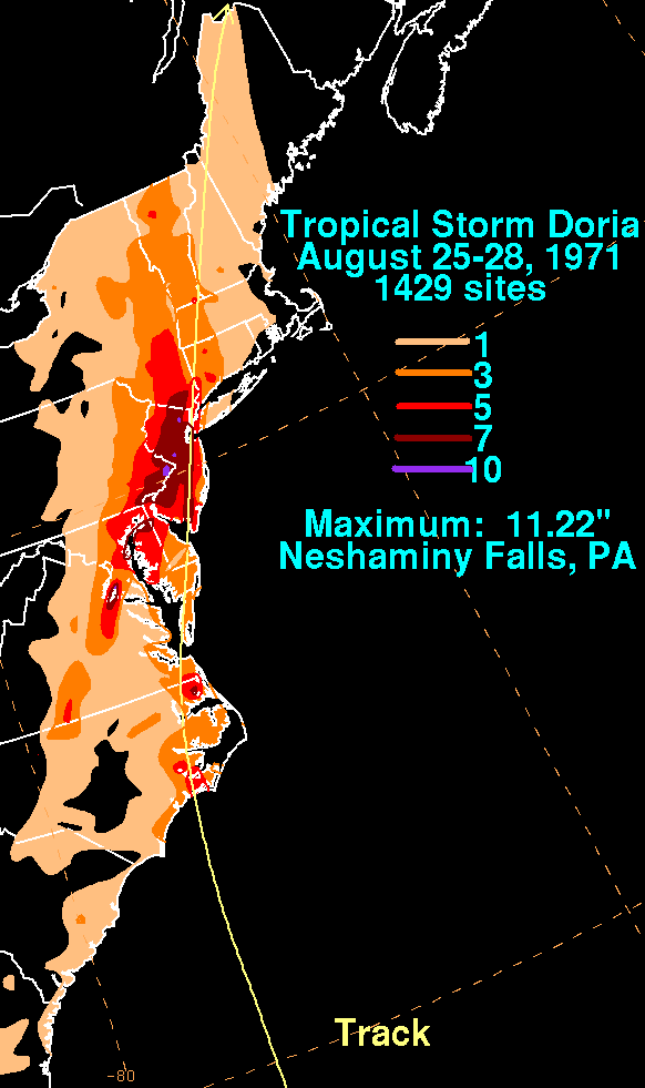
, peaking at 10.29 inches (261 mm) in Little Falls
. The rainfall led to record-breaking river levels and flooding in several houses, resulting in damage to dozens of houses across the state. Moderate damage and rainfall continued along its path into New England
and southeastern Canada
. In all, Tropical Storm Doria caused seven deaths and $147.6 million (1971 USD
, $ USD).
moved off the coast of Africa
, and tracked westward while slowly organizing. On August 20, subsequent to the development of a low-level circulation, an area of convection along the wave developed into a tropical depression while located about 1,000 miles (1,600 km) east-northeast of Grenada
. Initially failing to organize further, the depression moved to the west-northwest, and on August 23, it passed through the northern Lesser Antilles
. The depression moved to the north of Puerto Rico
, Hispaniola
, and the Bahamas, and began to show further signs of organization on August 25. After briefly weakening on August 26, the depression re-strengthened while turning to the north, and attained tropical storm status on August 27 while located 230 miles (370 km) east of Daytona Beach, Florida
.
After reaching tropical storm status, Doria quickly intensified as its wind field expanded while moving northward. The minimum central pressure quickly dropped, as well, and late on August 27, Doria reached its peak intensity of 65 mph (105 km/h) while making landfall
on North Carolina
near Morehead City
. The storm maintained its peak winds as it moved north-northeastward through North Carolina, and weakened slightly to a 60 mph (95 km/h) tropical storm after entering Virginia
on August 28. Doria turned to the northeast, passing through the Chesapeake Bay
and Delmarva Peninsula
before entering southern New Jersey
. It paralleled the state a short distance inland, and after moving through New York City
Doria became extratropical over northwestern Maine
on August 29. The extratropical remnant continued northeastward until losing its identity near the border of New Brunswick
and Quebec
in Canada
.
 Doria passed near or through the northern Caribbean Islands and the Bahamas as a tropical depression, though effects, if any, are unknown. Tropical Storm Doria passed about 160 miles (260 km) east of Charleston, South Carolina
, though its large wind field produced 22 mph (35 km/h) winds in the town. The storm also dropped light rainfall of up to 1.75 inches (44 mm), and resulted in a storm tide
of 5.7 feet (1.7 m) above the mean low water level.
Upon making landfall in North Carolina
, Doria produced a storm tide of 2 feet (0.6 m) above normal at Cape Fear. Sustained winds in the state peaked at 41 mph (66 km/h) in Hatteras
, while gusts reached 69 mph (111 km/h) in Atlantic Beach
. In most areas, wind damage was minimal. Tropical Storm Doria dropped moderate rainfall across the state, including a report of 4.17 inches (106 mm) in Cape Hatteras. Over 5 inches (125 mm) of rain fell around the Albemarle Sound
and near New Bern
. The rainfall led to flooding and mudslides, which blocked roads and highways. In localized areas, the flooding caused severe damage to roads and houses. Flooding from Doria also damaged water and sewage systems. Rainfall in the state persisted for two weeks after the passage of Doria.
In Virginia
, the storm produced a storm tide of 3.6 feet (1.1 m) above normal in Norfolk
. Sustained winds peaked at 60 mph (95 km/h) in Langley Air Force Base, while gusts reached 71 mph (114 km/h) in Norfolk. The bands
of the storm spawned an F1
tornado near Portsmouth
and Chesapeake
, damaging twelve homes and downing hundreds of trees. Damage from the tornado amounted to $250,000 (1971 USD, $ USD). Rainfall from Doria was moderate, peaking at 6.44 inches (164 mm) at a location 2 miles (3.2 km) south-southeast of Halifax
. One person drowned in Alexandria
when she fell into a draining ditch. The storm severely damaged a large warehouse in Norfolk, as well. Damage in Virginia totaled $375,000 (1971 USD, $ USD). Floodwaters from Doria clogged sewage systems near Norfolk, Virginia
with sand and silt. This forced the sewage to be dumped into the Chesapeake Bay
, resulting in the closure of several beaches for days.
 Tropical Storm Doria dropped 3.85 inches (98 mm) of rain in Washington National Airport in Washington, D.C.
In Maryland
, the storm resulted in tides 2.7 feet (0.8 m) above normal in Fort Henry
. Rainfall in the state peaked at 4.39 inches (112 mm) in Baltimore, while wind gusts reached a maximum of 63 mph (101 km/h) at the United States Coast Guard
station in Ocean City
. The storm produced 5.09 inches (129 mm) of rain in Wilmington, Delaware
and a storm tide of 3.2 feet (1 m) above normal in Lewes
. In Pennsylvania
, the passage of Tropical Storm Doria resulted in 6.57 inches (167 mm) of rain and peak wind gusts of 73 mph (117 km/h) in Philadelphia. Moderate winds downed trees and power lines in Pennsylvania, and one person died in the state. Several rivers in the southeastern portion of the state experienced record-breaking flooding.
In New Jersey
, Doria produced wind gusts of up to 54 mph (87 km/h) and storm tide
s 5.3 feet (1.6 m) above normal in Atlantic City
. The outer bands of the storm spawned an F2 tornado near Cape May
. It moved quickly northward through Cape May County
, and caused about $250,000 in damage (1971 USD, $ USD) in damage along its 29 mile (47 km) path. The storm dropped heavy rainfall, peaking at 10.29 inches (261 mm) in Little Falls
. Record 24-hour rainfall totals occurred in Newark
with 7.84 inches (199 mm) and Trenton
with 7.55 inches (192 mm). The rainfall led to record flooding on several small streams in the state. The Beden Brook
crested at over 5 feet (1.5 m) above normal, which destroyed a bridge near Princeton
. The Raritan River
at Manville
crested at 9.8 feet (3 m), a record stood until the passage of Hurricane Floyd
in 1999. The heavy rainfall overtopped the levee system in Zarephath
, causing severe damage to the Alma White College
and preventing it from opening in the fall of 1971. The rainfall also flooded two fire houses in Somerville
with several feet of water, and the water treatment plant in Bridgewater Township
with 18 inches (457 mm) of floodwaters in what was catalogued as a 50-year flood event
. Following the flooding to the water treatment plant, officials raised the beams of the plant to withstand a 500-year flood event
. Eleven houses experienced flooding damage in Montgomery Township
. Doria killed three people and caused $138 million in damage (1971 USD, $ USD) in the state.
with gusts to 48 mph (77 km/h). The storm tide reached 3.8 feet (1.2 m) above normal at Battery Park, and rainfall peaked at 5.96 inches (151 mm). LaGuardia Airport
recorded 2.29 inches (58 mm) of rain in a one-hour period. The threat of the storm cancelled a baseball game between the Los Angeles Dodgers
and the New York Mets
. Heavy rainfall flooded streets and subways in New York. In Connecticut
, Doria produced up to 3.12 inches (79 mm) of rain and wind gusts peaking at 48 mph (77 km/h) in Hartford
. Doria dropped light rain in Rhode Island
, including a report of 0.97 inches (25 mm) in Providence
. The storm also produced wind gusts of up to 61 mph (98 km/h) and a storm tide of 5.9 feet (1.8 m) above mean water level. In Boston
, rainfall totaled to 0.83 inches (21 mm), while wind gusts peaked at 80 mph (130 km/h) at the Blue Hill Meteorological Observatory
. Two people drowned in Marblehead
when they were swept away by surf from the storm.
The storm dropped moderate rainfall in Vermont
, including a total of 5.73 inches (141 mm) in Mays Mill. The rainfall caused road washouts, landslides, and damage to bridges in the southeast portion of the state. The center of Tropical Storm Doria passed over south-central New Hampshire
, resulting in heavy rains and damaging winds. Sustained winds in Maine
were generally around 30 mph (48 km/h), while gusts peaked at 61 mph (98 km/h) in Lewiston
. The strong winds resulted in downed trees and widespread outages to power and telephone service. The winds also damaged a mobile home in Sabattus
and a steel shed in Lewiston. Doria produced moderate rainfall, including a total of 1.75 inches (44 mm) in Lewiston, though little flooding occurred.
Moisture from Tropical Storm Doria entered southeastern Canada
, peaking at over 3 inches (75 mm) in the Montérégie
region of Quebec
. The rainfall led to severe flooding in Victoriaville, causing damage to roads, bridges, and crops. Damage totaled to about $250,000 (1971 CND, $245,000 1971 USD, $ USD).
Throughout its path, Tropical Storm Doria caused seven deaths and $147.6 million in damage (1971 USD, $ USD).
In early September 1971, President
Richard Nixon
declared counties in New Jersey, New York, and Pennsylvania as disaster areas due to heavy rains and flooding. This allowed citizens in disaster areas to apply for federal assistance.
Tropical cyclone
A tropical cyclone is a storm system characterized by a large low-pressure center and numerous thunderstorms that produce strong winds and heavy rain. Tropical cyclones strengthen when water evaporated from the ocean is released as the saturated air rises, resulting in condensation of water vapor...
in the 1971 Atlantic hurricane season
1971 Atlantic hurricane season
The 1971 Atlantic hurricane season was fairly active with several notable storms. Hurricane Edith, the strongest of the season, was a Category 5 on the Saffir-Simpson scale, the highest category on the scale. It struck Nicaragua at peak intensity, killing dozens, and later hit southern Louisiana...
. The fifth tropical storm of the season, Doria developed from a tropical wave
Tropical wave
Tropical waves, easterly waves, or tropical easterly waves, also known as African easterly waves in the Atlantic region, are a type of atmospheric trough, an elongated area of relatively low air pressure, oriented north to south, which move from east to west across the tropics causing areas of...
on August 20 to the east of the Lesser Antilles
Lesser Antilles
The Lesser Antilles are a long, partly volcanic island arc in the Western Hemisphere. Most of its islands form the eastern boundary of the Caribbean Sea with the Atlantic Ocean, with the remainder located in the southern Caribbean just north of South America...
, and after five days without development it attained tropical storm status to the east of Florida
Florida
Florida is a state in the southeastern United States, located on the nation's Atlantic and Gulf coasts. It is bordered to the west by the Gulf of Mexico, to the north by Alabama and Georgia and to the east by the Atlantic Ocean. With a population of 18,801,310 as measured by the 2010 census, it...
. Doria turned to the north, and reached peak winds of 65 mph (105 km/h) as it was making landfall near Morehead City, North Carolina
Morehead City, North Carolina
Morehead City is a port city in Carteret County, North Carolina, United States. The population was 8,661 at the 2010 census. Morehead City celebrated the 150th anniversary of its founding on May 5, 2007...
. It turned to the northeast, and moved through the Mid-Atlantic
Mid-Atlantic States
The Mid-Atlantic states, also called middle Atlantic states or simply the mid Atlantic, form a region of the United States generally located between New England and the South...
and New England
New England
New England is a region in the northeastern corner of the United States consisting of the six states of Maine, New Hampshire, Vermont, Massachusetts, Rhode Island, and Connecticut...
as a tropical storm before becoming an extratropical storm over Maine
Maine
Maine is a state in the New England region of the northeastern United States, bordered by the Atlantic Ocean to the east and south, New Hampshire to the west, and the Canadian provinces of Quebec to the northwest and New Brunswick to the northeast. Maine is both the northernmost and easternmost...
on August 29.
In North Carolina
North Carolina
North Carolina is a state located in the southeastern United States. The state borders South Carolina and Georgia to the south, Tennessee to the west and Virginia to the north. North Carolina contains 100 counties. Its capital is Raleigh, and its largest city is Charlotte...
, Doria produced moderate rainfall, resulting in localized flooding and damage. The storm spawned a tornado near Norfolk, Virginia
Norfolk, Virginia
Norfolk is an independent city in the Commonwealth of Virginia in the United States. With a population of 242,803 as of the 2010 Census, it is Virginia's second-largest city behind neighboring Virginia Beach....
, damaging twelve houses and downing hundreds of trees. Tropical Storm Doria dropped heavy precipitation in New Jersey
New Jersey
New Jersey is a state in the Northeastern and Middle Atlantic regions of the United States. , its population was 8,791,894. It is bordered on the north and east by the state of New York, on the southeast and south by the Atlantic Ocean, on the west by Pennsylvania and on the southwest by Delaware...
, peaking at 10.29 inches (261 mm) in Little Falls
Little Falls, New Jersey
Little Falls is a township in Passaic County, New Jersey, United States. As of the 2000 United States Census, the township population was 10,855. It is located about from New York City....
. The rainfall led to record-breaking river levels and flooding in several houses, resulting in damage to dozens of houses across the state. Moderate damage and rainfall continued along its path into New England
New England
New England is a region in the northeastern corner of the United States consisting of the six states of Maine, New Hampshire, Vermont, Massachusetts, Rhode Island, and Connecticut...
and southeastern Canada
Canada
Canada is a North American country consisting of ten provinces and three territories. Located in the northern part of the continent, it extends from the Atlantic Ocean in the east to the Pacific Ocean in the west, and northward into the Arctic Ocean...
. In all, Tropical Storm Doria caused seven deaths and $147.6 million (1971 USD
United States dollar
The United States dollar , also referred to as the American dollar, is the official currency of the United States of America. It is divided into 100 smaller units called cents or pennies....
, $ USD).
Meteorological history
On August 15, a tropical waveTropical wave
Tropical waves, easterly waves, or tropical easterly waves, also known as African easterly waves in the Atlantic region, are a type of atmospheric trough, an elongated area of relatively low air pressure, oriented north to south, which move from east to west across the tropics causing areas of...
moved off the coast of Africa
Africa
Africa is the world's second largest and second most populous continent, after Asia. At about 30.2 million km² including adjacent islands, it covers 6% of the Earth's total surface area and 20.4% of the total land area...
, and tracked westward while slowly organizing. On August 20, subsequent to the development of a low-level circulation, an area of convection along the wave developed into a tropical depression while located about 1,000 miles (1,600 km) east-northeast of Grenada
Grenada
Grenada is an island country and Commonwealth Realm consisting of the island of Grenada and six smaller islands at the southern end of the Grenadines in the southeastern Caribbean Sea...
. Initially failing to organize further, the depression moved to the west-northwest, and on August 23, it passed through the northern Lesser Antilles
Lesser Antilles
The Lesser Antilles are a long, partly volcanic island arc in the Western Hemisphere. Most of its islands form the eastern boundary of the Caribbean Sea with the Atlantic Ocean, with the remainder located in the southern Caribbean just north of South America...
. The depression moved to the north of Puerto Rico
Puerto Rico
Puerto Rico , officially the Commonwealth of Puerto Rico , is an unincorporated territory of the United States, located in the northeastern Caribbean, east of the Dominican Republic and west of both the United States Virgin Islands and the British Virgin Islands.Puerto Rico comprises an...
, Hispaniola
Hispaniola
Hispaniola is a major island in the Caribbean, containing the two sovereign states of the Dominican Republic and Haiti. The island is located between the islands of Cuba to the west and Puerto Rico to the east, within the hurricane belt...
, and the Bahamas, and began to show further signs of organization on August 25. After briefly weakening on August 26, the depression re-strengthened while turning to the north, and attained tropical storm status on August 27 while located 230 miles (370 km) east of Daytona Beach, Florida
Daytona Beach, Florida
Daytona Beach is a city in Volusia County, Florida, USA. According to 2008 U.S. Census Bureau estimates, the city has a population of 64,211. Daytona Beach is a principal city of the Deltona – Daytona Beach – Ormond Beach, Florida Metropolitan Statistical Area, which the census bureau estimated had...
.
After reaching tropical storm status, Doria quickly intensified as its wind field expanded while moving northward. The minimum central pressure quickly dropped, as well, and late on August 27, Doria reached its peak intensity of 65 mph (105 km/h) while making landfall
Landfall (meteorology)
Landfall is the event of a tropical cyclone or a waterspout coming onto land after being over water. When a waterspout makes landfall it is reclassified as a tornado, which can then cause damage inland...
on North Carolina
North Carolina
North Carolina is a state located in the southeastern United States. The state borders South Carolina and Georgia to the south, Tennessee to the west and Virginia to the north. North Carolina contains 100 counties. Its capital is Raleigh, and its largest city is Charlotte...
near Morehead City
Morehead City, North Carolina
Morehead City is a port city in Carteret County, North Carolina, United States. The population was 8,661 at the 2010 census. Morehead City celebrated the 150th anniversary of its founding on May 5, 2007...
. The storm maintained its peak winds as it moved north-northeastward through North Carolina, and weakened slightly to a 60 mph (95 km/h) tropical storm after entering Virginia
Virginia
The Commonwealth of Virginia , is a U.S. state on the Atlantic Coast of the Southern United States. Virginia is nicknamed the "Old Dominion" and sometimes the "Mother of Presidents" after the eight U.S. presidents born there...
on August 28. Doria turned to the northeast, passing through the Chesapeake Bay
Chesapeake Bay
The Chesapeake Bay is the largest estuary in the United States. It lies off the Atlantic Ocean, surrounded by Maryland and Virginia. The Chesapeake Bay's drainage basin covers in the District of Columbia and parts of six states: New York, Pennsylvania, Delaware, Maryland, Virginia, and West...
and Delmarva Peninsula
Delmarva Peninsula
The Delmarva Peninsula is a large peninsula on the East Coast of the United States, occupied by most of Delaware and portions of Maryland and Virginia...
before entering southern New Jersey
New Jersey
New Jersey is a state in the Northeastern and Middle Atlantic regions of the United States. , its population was 8,791,894. It is bordered on the north and east by the state of New York, on the southeast and south by the Atlantic Ocean, on the west by Pennsylvania and on the southwest by Delaware...
. It paralleled the state a short distance inland, and after moving through New York City
New York City
New York is the most populous city in the United States and the center of the New York Metropolitan Area, one of the most populous metropolitan areas in the world. New York exerts a significant impact upon global commerce, finance, media, art, fashion, research, technology, education, and...
Doria became extratropical over northwestern Maine
Maine
Maine is a state in the New England region of the northeastern United States, bordered by the Atlantic Ocean to the east and south, New Hampshire to the west, and the Canadian provinces of Quebec to the northwest and New Brunswick to the northeast. Maine is both the northernmost and easternmost...
on August 29. The extratropical remnant continued northeastward until losing its identity near the border of New Brunswick
New Brunswick
New Brunswick is one of Canada's three Maritime provinces and is the only province in the federation that is constitutionally bilingual . The provincial capital is Fredericton and Saint John is the most populous city. Greater Moncton is the largest Census Metropolitan Area...
and Quebec
Quebec
Quebec or is a province in east-central Canada. It is the only Canadian province with a predominantly French-speaking population and the only one whose sole official language is French at the provincial level....
in Canada
Canada
Canada is a North American country consisting of ten provinces and three territories. Located in the northern part of the continent, it extends from the Atlantic Ocean in the east to the Pacific Ocean in the west, and northward into the Arctic Ocean...
.
Southeast United States and Virginia
Charleston, South Carolina
Charleston is the second largest city in the U.S. state of South Carolina. It was made the county seat of Charleston County in 1901 when Charleston County was founded. The city's original name was Charles Towne in 1670, and it moved to its present location from a location on the west bank of the...
, though its large wind field produced 22 mph (35 km/h) winds in the town. The storm also dropped light rainfall of up to 1.75 inches (44 mm), and resulted in a storm tide
Storm tide
A storm tide is a tide with a high flood period caused by a storm. Storm tides can be a severe danger to the coast and the people living along the coast. The water level can rise to more than 5 meters above the normal tide....
of 5.7 feet (1.7 m) above the mean low water level.
Upon making landfall in North Carolina
North Carolina
North Carolina is a state located in the southeastern United States. The state borders South Carolina and Georgia to the south, Tennessee to the west and Virginia to the north. North Carolina contains 100 counties. Its capital is Raleigh, and its largest city is Charlotte...
, Doria produced a storm tide of 2 feet (0.6 m) above normal at Cape Fear. Sustained winds in the state peaked at 41 mph (66 km/h) in Hatteras
Hatteras, North Carolina
Hatteras is an unincorporated community in Dare County, North Carolina, United States, on the Outer Banks island of Hatteras. North Carolina Highway 12 passes through the community linking it to Frisco and Ocracoke . It is south of the famous Cape Hatteras and the Cape Hatteras Lighthouse in Buxton...
, while gusts reached 69 mph (111 km/h) in Atlantic Beach
Atlantic Beach, North Carolina
-Demographics:As of the census of 2008, there were 1,815 people, 971 households, and 498 families residing in the town. The population density was . There were 4,728 housing units at an average density of 2,206.0 per square mile...
. In most areas, wind damage was minimal. Tropical Storm Doria dropped moderate rainfall across the state, including a report of 4.17 inches (106 mm) in Cape Hatteras. Over 5 inches (125 mm) of rain fell around the Albemarle Sound
Albemarle Sound
Albemarle Sound is a large estuary on the coast of North Carolina in the United States located at the confluence of a group of rivers, including the Chowan and Roanoke. It is separated from the Atlantic Ocean by the Outer Banks, a long barrier peninsula upon which the town of Kitty Hawk is located,...
and near New Bern
New Bern, North Carolina
New Bern is a city in Craven County, North Carolina with a population of 29,524 as of the 2010 census.. It is located at the confluence of the Trent and the Neuse rivers...
. The rainfall led to flooding and mudslides, which blocked roads and highways. In localized areas, the flooding caused severe damage to roads and houses. Flooding from Doria also damaged water and sewage systems. Rainfall in the state persisted for two weeks after the passage of Doria.
In Virginia
Virginia
The Commonwealth of Virginia , is a U.S. state on the Atlantic Coast of the Southern United States. Virginia is nicknamed the "Old Dominion" and sometimes the "Mother of Presidents" after the eight U.S. presidents born there...
, the storm produced a storm tide of 3.6 feet (1.1 m) above normal in Norfolk
Norfolk, Virginia
Norfolk is an independent city in the Commonwealth of Virginia in the United States. With a population of 242,803 as of the 2010 Census, it is Virginia's second-largest city behind neighboring Virginia Beach....
. Sustained winds peaked at 60 mph (95 km/h) in Langley Air Force Base, while gusts reached 71 mph (114 km/h) in Norfolk. The bands
Rainband
A rainband is a cloud and precipitation structure associated with an area of rainfall which is significantly elongated. Rainbands can be stratiform or convective, and are generated by differences in temperature. When noted on weather radar imagery, this precipitation elongation is referred to as...
of the storm spawned an F1
Fujita scale
The Fujita scale , or Fujita-Pearson scale, is a scale for rating tornado intensity, based primarily on the damage tornadoes inflict on human-built structures and vegetation...
tornado near Portsmouth
Portsmouth, Virginia
Portsmouth is located in the Hampton Roads metropolitan area of the U.S. Commonwealth of Virginia. As of 2010, the city had a total population of 95,535.The Norfolk Naval Shipyard, often called the Norfolk Navy Yard, is a historic and active U.S...
and Chesapeake
Chesapeake, Virginia
As of the census of 2000, there were 199,184 people, 69,900 households, and 54,172 families residing in the city. The population density was 584.6 people per square mile . There were 72,672 housing units at an average density of 213.3 per square mile...
, damaging twelve homes and downing hundreds of trees. Damage from the tornado amounted to $250,000 (1971 USD, $ USD). Rainfall from Doria was moderate, peaking at 6.44 inches (164 mm) at a location 2 miles (3.2 km) south-southeast of Halifax
Halifax, Virginia
Halifax is a town in Halifax County, Virginia, United States, along the Banister River. The population was 1,389 at the 2000 census. It is the county seat of Halifax County.-Geography:Halifax is located at ....
. One person drowned in Alexandria
Alexandria, Virginia
Alexandria is an independent city in the Commonwealth of Virginia. As of 2009, the city had a total population of 139,966. Located along the Western bank of the Potomac River, Alexandria is approximately six miles south of downtown Washington, D.C.Like the rest of northern Virginia, as well as...
when she fell into a draining ditch. The storm severely damaged a large warehouse in Norfolk, as well. Damage in Virginia totaled $375,000 (1971 USD, $ USD). Floodwaters from Doria clogged sewage systems near Norfolk, Virginia
Norfolk, Virginia
Norfolk is an independent city in the Commonwealth of Virginia in the United States. With a population of 242,803 as of the 2010 Census, it is Virginia's second-largest city behind neighboring Virginia Beach....
with sand and silt. This forced the sewage to be dumped into the Chesapeake Bay
Chesapeake Bay
The Chesapeake Bay is the largest estuary in the United States. It lies off the Atlantic Ocean, surrounded by Maryland and Virginia. The Chesapeake Bay's drainage basin covers in the District of Columbia and parts of six states: New York, Pennsylvania, Delaware, Maryland, Virginia, and West...
, resulting in the closure of several beaches for days.
Mid-Atlantic states
Washington, D.C.
Washington, D.C., formally the District of Columbia and commonly referred to as Washington, "the District", or simply D.C., is the capital of the United States. On July 16, 1790, the United States Congress approved the creation of a permanent national capital as permitted by the U.S. Constitution....
In Maryland
Maryland
Maryland is a U.S. state located in the Mid Atlantic region of the United States, bordering Virginia, West Virginia, and the District of Columbia to its south and west; Pennsylvania to its north; and Delaware to its east...
, the storm resulted in tides 2.7 feet (0.8 m) above normal in Fort Henry
Fort Henry
Fort Henry is the name of:*Fort Henry , a 1646 fort near present-day Petersburg, Virginia*Fort Henry , a 1774 fort near present–day Wheeling, West Virginia...
. Rainfall in the state peaked at 4.39 inches (112 mm) in Baltimore, while wind gusts reached a maximum of 63 mph (101 km/h) at the United States Coast Guard
United States Coast Guard
The United States Coast Guard is a branch of the United States Armed Forces and one of the seven U.S. uniformed services. The Coast Guard is a maritime, military, multi-mission service unique among the military branches for having a maritime law enforcement mission and a federal regulatory agency...
station in Ocean City
Ocean City, Maryland
Ocean City, sometimes known as OC, or OCMD, is an Atlantic Ocean resort town in Worcester County, Maryland, United States. Ocean City is widely known in the Mid-Atlantic region of the United States and is a frequent destination for vacationers in that area...
. The storm produced 5.09 inches (129 mm) of rain in Wilmington, Delaware
Wilmington, Delaware
Wilmington is the largest city in the state of Delaware, United States, and is located at the confluence of the Christina River and Brandywine Creek, near where the Christina flows into the Delaware River. It is the county seat of New Castle County and one of the major cities in the Delaware Valley...
and a storm tide of 3.2 feet (1 m) above normal in Lewes
Lewes, Delaware
Lewes is an incorporated city in Sussex County, Delaware, USA, on the Delmarva Peninsula. According to the 2010 census, the population is 2,747, a decrease of 6.3% from 2000....
. In Pennsylvania
Pennsylvania
The Commonwealth of Pennsylvania is a U.S. state that is located in the Northeastern and Mid-Atlantic regions of the United States. The state borders Delaware and Maryland to the south, West Virginia to the southwest, Ohio to the west, New York and Ontario, Canada, to the north, and New Jersey to...
, the passage of Tropical Storm Doria resulted in 6.57 inches (167 mm) of rain and peak wind gusts of 73 mph (117 km/h) in Philadelphia. Moderate winds downed trees and power lines in Pennsylvania, and one person died in the state. Several rivers in the southeastern portion of the state experienced record-breaking flooding.
In New Jersey
New Jersey
New Jersey is a state in the Northeastern and Middle Atlantic regions of the United States. , its population was 8,791,894. It is bordered on the north and east by the state of New York, on the southeast and south by the Atlantic Ocean, on the west by Pennsylvania and on the southwest by Delaware...
, Doria produced wind gusts of up to 54 mph (87 km/h) and storm tide
Storm tide
A storm tide is a tide with a high flood period caused by a storm. Storm tides can be a severe danger to the coast and the people living along the coast. The water level can rise to more than 5 meters above the normal tide....
s 5.3 feet (1.6 m) above normal in Atlantic City
Atlantic City, New Jersey
Atlantic City is a city in Atlantic County, New Jersey, United States, and a nationally renowned resort city for gambling, shopping and fine dining. The city also served as the inspiration for the American version of the board game Monopoly. Atlantic City is located on Absecon Island on the coast...
. The outer bands of the storm spawned an F2 tornado near Cape May
Cape May, New Jersey
Cape May is a city at the southern tip of Cape May Peninsula in Cape May County, New Jersey, where the Delaware Bay meets the Atlantic Ocean and is one of the country's oldest vacation resort destinations. It is part of the Ocean City Metropolitan Statistical Area. As of the 2010 United States...
. It moved quickly northward through Cape May County
Cape May County, New Jersey
-Climate:Being the southernmost point in New Jersey, Cape May has fairly mild wintertime temperatures. Contrary to that, the summertime has lower temperatures than most places in the state, making the county a popular place to escape the heat. It is in zone 7a/7b, which is the same as parts of...
, and caused about $250,000 in damage (1971 USD, $ USD) in damage along its 29 mile (47 km) path. The storm dropped heavy rainfall, peaking at 10.29 inches (261 mm) in Little Falls
Little Falls, New Jersey
Little Falls is a township in Passaic County, New Jersey, United States. As of the 2000 United States Census, the township population was 10,855. It is located about from New York City....
. Record 24-hour rainfall totals occurred in Newark
Newark, New Jersey
Newark is the largest city in the American state of New Jersey, and the seat of Essex County. As of the 2010 United States Census, Newark had a population of 277,140, maintaining its status as the largest municipality in New Jersey. It is the 68th largest city in the U.S...
with 7.84 inches (199 mm) and Trenton
Trenton, New Jersey
Trenton is the capital of the U.S. state of New Jersey and the county seat of Mercer County. As of the 2010 United States Census, Trenton had a population of 84,913...
with 7.55 inches (192 mm). The rainfall led to record flooding on several small streams in the state. The Beden Brook
Beden Brook
Beden Brook, also Bedens Brook, Beden's Brook, or Beeden's Brook, is a tributary of the Millstone River in central New Jersey in the United States.-Course:The headwaters of the brook are variously given...
crested at over 5 feet (1.5 m) above normal, which destroyed a bridge near Princeton
Princeton, New Jersey
Princeton is a community located in Mercer County, New Jersey, United States. It is best known as the location of Princeton University, which has been sited in the community since 1756...
. The Raritan River
Raritan River
The Raritan River is a major river of central New Jersey in the United States. Its watershed drains much of the mountainous area of the central part of the state, emptying into the Raritan Bay on the Atlantic Ocean.-Description:...
at Manville
Manville, New Jersey
Manville is a Borough in Somerset County, New Jersey, United States. As of the 2010 United States Census, the borough population was 10,344. Manville was named after the Johns-Manville Corporation, which maintained a large manufacturing facility in the borough for decades.Historically, many of...
crested at 9.8 feet (3 m), a record stood until the passage of Hurricane Floyd
Hurricane Floyd
Hurricane Floyd was the sixth named storm, fourth hurricane, and third major hurricane in the 1999 Atlantic hurricane season. Floyd triggered the third largest evacuation in US history when 2.6 million coastal residents of five states were ordered from their homes as it approached...
in 1999. The heavy rainfall overtopped the levee system in Zarephath
Zarephath, New Jersey
Zarephath is an unincorporated area of Franklin Township in Somerset County, New Jersey, United States. It was the communal home to the Pillar of Fire Church, and was the worldwide headquarters of Pillar of Fire International and housed the church's college, Somerset Christian College, and radio...
, causing severe damage to the Alma White College
Alma White College
Alma White College was a Bible college in Zarephath, New Jersey from 1921 to 1978. It was an institution of the Pillar of Fire Church.-History:...
and preventing it from opening in the fall of 1971. The rainfall also flooded two fire houses in Somerville
Somerville, New Jersey
Somerville is a borough in Somerset County, New Jersey, United States. As of the 2010 United States Census, the borough population was 12,098. It is the county seat of Somerset County....
with several feet of water, and the water treatment plant in Bridgewater Township
Bridgewater Township, New Jersey
Bridgewater Township is a township in Somerset County, New Jersey, United States. , the township population was 44,464.Bridgewater Township was originally created by Royal Charter on April 4, 1749, from portions of the Northern precinct, and was incorporated as one of New Jersey's initial group of...
with 18 inches (457 mm) of floodwaters in what was catalogued as a 50-year flood event
100-year flood
A one-hundred-year flood is calculated to be the level of flood water expected to be equaled or exceeded every 100 years on average. The 100-year flood is more accurately referred to as the 1% annual exceedance probability flood, since it is a flood that has a 1% chance of being equaled or exceeded...
. Following the flooding to the water treatment plant, officials raised the beams of the plant to withstand a 500-year flood event
100-year flood
A one-hundred-year flood is calculated to be the level of flood water expected to be equaled or exceeded every 100 years on average. The 100-year flood is more accurately referred to as the 1% annual exceedance probability flood, since it is a flood that has a 1% chance of being equaled or exceeded...
. Eleven houses experienced flooding damage in Montgomery Township
Montgomery Township, New Jersey
Montgomery Township is a Township in Somerset County, New Jersey, United States. As of the United States 2010 Census, the township population was 22,254, which represents growth of 27% since 2000 and more than 130% since the 1990 Census population figure of 9,612.Montgomery Township was...
. Doria killed three people and caused $138 million in damage (1971 USD, $ USD) in the state.
Northeast United States and Canada
Tropical Storm Doria produced moderate winds in New York CityNew York City
New York is the most populous city in the United States and the center of the New York Metropolitan Area, one of the most populous metropolitan areas in the world. New York exerts a significant impact upon global commerce, finance, media, art, fashion, research, technology, education, and...
with gusts to 48 mph (77 km/h). The storm tide reached 3.8 feet (1.2 m) above normal at Battery Park, and rainfall peaked at 5.96 inches (151 mm). LaGuardia Airport
LaGuardia Airport
LaGuardia Airport is an airport located in the northern part of Queens County on Long Island in the City of New York. The airport is located on the waterfront of Flushing Bay and Bowery Bay, and borders the neighborhoods of Astoria, Jackson Heights and East Elmhurst. The airport was originally...
recorded 2.29 inches (58 mm) of rain in a one-hour period. The threat of the storm cancelled a baseball game between the Los Angeles Dodgers
Los Angeles Dodgers
The Los Angeles Dodgers are a professional baseball team based in Los Angeles, California. The Dodgers are members of Major League Baseball's National League West Division. Established in 1883, the team originated in Brooklyn, New York, where it was known by a number of nicknames before becoming...
and the New York Mets
New York Mets
The New York Mets are a professional baseball team based in the borough of Queens in New York City, New York. They belong to Major League Baseball's National League East Division. One of baseball's first expansion teams, the Mets were founded in 1962 to replace New York's departed National League...
. Heavy rainfall flooded streets and subways in New York. In Connecticut
Connecticut
Connecticut is a state in the New England region of the northeastern United States. It is bordered by Rhode Island to the east, Massachusetts to the north, and the state of New York to the west and the south .Connecticut is named for the Connecticut River, the major U.S. river that approximately...
, Doria produced up to 3.12 inches (79 mm) of rain and wind gusts peaking at 48 mph (77 km/h) in Hartford
Hartford, Connecticut
Hartford is the capital of the U.S. state of Connecticut. The seat of Hartford County until Connecticut disbanded county government in 1960, it is the second most populous city on New England's largest river, the Connecticut River. As of the 2010 Census, Hartford's population was 124,775, making...
. Doria dropped light rain in Rhode Island
Rhode Island
The state of Rhode Island and Providence Plantations, more commonly referred to as Rhode Island , is a state in the New England region of the United States. It is the smallest U.S. state by area...
, including a report of 0.97 inches (25 mm) in Providence
Providence, Rhode Island
Providence is the capital and most populous city of Rhode Island and was one of the first cities established in the United States. Located in Providence County, it is the third largest city in the New England region...
. The storm also produced wind gusts of up to 61 mph (98 km/h) and a storm tide of 5.9 feet (1.8 m) above mean water level. In Boston
Boston
Boston is the capital of and largest city in Massachusetts, and is one of the oldest cities in the United States. The largest city in New England, Boston is regarded as the unofficial "Capital of New England" for its economic and cultural impact on the entire New England region. The city proper had...
, rainfall totaled to 0.83 inches (21 mm), while wind gusts peaked at 80 mph (130 km/h) at the Blue Hill Meteorological Observatory
Blue Hill Meteorological Observatory
The Blue Hill Meteorological Observatory, also known as Great Blue Hill Weather Observatory, Blue Hill Weather Observatory, or simply the Blue Hill Observatory, in Milton, Massachusetts is the foremost structure associated with the history of weather observations in the United States...
. Two people drowned in Marblehead
Marblehead, Massachusetts
Marblehead is a town in Essex County, Massachusetts, United States. The population was 19,808 at the 2010 census. It is home to the Marblehead Neck Wildlife Sanctuary and Devereux Beach...
when they were swept away by surf from the storm.
The storm dropped moderate rainfall in Vermont
Vermont
Vermont is a state in the New England region of the northeastern United States of America. The state ranks 43rd in land area, , and 45th in total area. Its population according to the 2010 census, 630,337, is the second smallest in the country, larger only than Wyoming. It is the only New England...
, including a total of 5.73 inches (141 mm) in Mays Mill. The rainfall caused road washouts, landslides, and damage to bridges in the southeast portion of the state. The center of Tropical Storm Doria passed over south-central New Hampshire
New Hampshire
New Hampshire is a state in the New England region of the northeastern United States of America. The state was named after the southern English county of Hampshire. It is bordered by Massachusetts to the south, Vermont to the west, Maine and the Atlantic Ocean to the east, and the Canadian...
, resulting in heavy rains and damaging winds. Sustained winds in Maine
Maine
Maine is a state in the New England region of the northeastern United States, bordered by the Atlantic Ocean to the east and south, New Hampshire to the west, and the Canadian provinces of Quebec to the northwest and New Brunswick to the northeast. Maine is both the northernmost and easternmost...
were generally around 30 mph (48 km/h), while gusts peaked at 61 mph (98 km/h) in Lewiston
Lewiston, Maine
Lewiston is a city in Androscoggin County in Maine, and the second-largest city in the state. The population was 41,592 at the 2010 census. It is one of two principal cities of and included within the Lewiston-Auburn, Maine metropolitan New England city and town area and the Lewiston-Auburn, Maine...
. The strong winds resulted in downed trees and widespread outages to power and telephone service. The winds also damaged a mobile home in Sabattus
Sabattus, Maine
Sabattus is a town in Androscoggin County, Maine, United States. The population was 4,486 at the 2000 census. It is included in both the Lewiston-Auburn, Maine Metropolitan Statistical Area and the Lewiston-Auburn, Maine Metropolitan New England City and Town Area...
and a steel shed in Lewiston. Doria produced moderate rainfall, including a total of 1.75 inches (44 mm) in Lewiston, though little flooding occurred.
Moisture from Tropical Storm Doria entered southeastern Canada
Canada
Canada is a North American country consisting of ten provinces and three territories. Located in the northern part of the continent, it extends from the Atlantic Ocean in the east to the Pacific Ocean in the west, and northward into the Arctic Ocean...
, peaking at over 3 inches (75 mm) in the Montérégie
Montérégie
Montérégie is an administrative region in southwest Québec. It includes the cities of Boucherville, Brossard, Granby, Longueuil, Salaberry-de-Valleyfield, Saint-Jean-sur-Richelieu, Saint-Hyacinthe, Sorel-Tracy, and Vaudreuil-Dorion....
region of Quebec
Quebec
Quebec or is a province in east-central Canada. It is the only Canadian province with a predominantly French-speaking population and the only one whose sole official language is French at the provincial level....
. The rainfall led to severe flooding in Victoriaville, causing damage to roads, bridges, and crops. Damage totaled to about $250,000 (1971 CND, $245,000 1971 USD, $ USD).
Throughout its path, Tropical Storm Doria caused seven deaths and $147.6 million in damage (1971 USD, $ USD).
In early September 1971, President
President of the United States
The President of the United States of America is the head of state and head of government of the United States. The president leads the executive branch of the federal government and is the commander-in-chief of the United States Armed Forces....
Richard Nixon
Richard Nixon
Richard Milhous Nixon was the 37th President of the United States, serving from 1969 to 1974. The only president to resign the office, Nixon had previously served as a US representative and senator from California and as the 36th Vice President of the United States from 1953 to 1961 under...
declared counties in New Jersey, New York, and Pennsylvania as disaster areas due to heavy rains and flooding. This allowed citizens in disaster areas to apply for federal assistance.
See also
- Hurricane Irene (2011)Hurricane Irene (2011)Hurricane Irene was a large and powerful Atlantic hurricane that left extensive flood and wind damage along its path through the Caribbean, the United States East Coast and as far north as Atlantic Canada in 2011...
- List of Delaware hurricanes
- List of New Jersey hurricanes
- List of New England hurricanes
- List of Delaware hurricanes