
.gif)
Hurricane Bertha (1996)
Encyclopedia
Hurricane Bertha was a strong, early season major hurricane which impacted areas from the Leeward Islands
to Atlantic Canada
. Bertha originated from a tropical wave
which moved off the eastern coast of Africa
in early July. By July 3, an area of low pressure
developed along the wave. The low gradually developed and was classified a tropical depression on July 5 about midway between the Lesser Antilles
and Africa. Traveling towards the west-northwest, the depression intensified, reaching hurricane-status on July 7. On July 9, a brief period of rapid intensification
took place and Bertha reached its peak intensity with winds of 115 mph (185 km/h) while located about 60 mi (95 km) of the Turks and Caicos Islands.
emerged off of the coast of Africa
. On July 3, a weak low-level circulation developed while located 500 miles (804.7 km) south of Cape Verde
. The disturbance moved westward, and on July 5, it strengthened into a tropical depression in the central Atlantic. The depression tracked westward across the open waters of the Atlantic along the western periphery of a subtropical ridge. Later that day, the depression was upgraded to a tropical storm. Over the next three days, Bertha tracked west-northwest while gradual intensification was occurring. On July 7, Tropical Storm Bertha was upgraded to a hurricane with sustained winds of 75 mph (120 km/h) while east of Guadeloupe.
The next day, the center of circulation passed over Antigua
as Bertha traversed the extreme northeastern portion of the Caribbean Sea
causing moderate to minor damages. After that, Bertha passed rapidly in the southern portion of Sint Maarten, 10 months after Hurricane Luis
ravaged the island as a strong category 1 hurricane causing moderate damage to homes,and uprooted trees, sunk boats. Pressure fall to 985 mb and gust over 75 mph (120 km/h) in the Princess Juliana Airport. The storm gradually turned to the northwest on July 9 as maximum sustained winds reached 100 knots (196 km/h) while located 120 miles (193.1 km) northwest of Puerto Rico. Because the highest winds were located on the northeastern portion of the circulation, Puerto Rico received only tropical storm force winds near 50 mph. Forward speed slowed to 15 mph (25 km/h) as Bertha passed within 60 miles (100 km) of the Turks and Caicos, just before reaching its peak intensity.
Continuing its gradual turn, the track soon became north-northwest as the forward speed slowed further to 10 mph (16 km/h) on July 10 and July 11. On July 12, Bertha made landfall between Wrightsville Beach
and Topsail Beach
. Bertha lost hurricane intensity just after landfall. It then accelerated to the northeast along the East Coast of the United States
, producing winds of up to 60 mph (100 km/h). It moved north, and lost all of its tropical characteristics by July 18.
, rainfall from Bertha peaked at 3.28 in (83.3 mm) on St. Thomas. Winds from the storm were reported to be sustained at 85 mph (140 km/h) with an unofficial reading of 100 mph (155 km/h). The Federal Emergency Management Agency
(FEMA) reported that 1,415 homes were damaged, of which 43 lost their roofs. Two boats were destroyed, five were grounded, and nine others washed ashore. One injury occurred in Coral Bay as a man rode out the storm in his sailboat. Damages from the storm were estimated at $7.5 million (1996 USD
).
in Naguabo. Wind reports from the Roosevelt Roads Naval Base on July 8 indicated a maximum sustained wind of 44 mi/h. Although heavy rain did occur, there was no widespread or significant inland flooding reported. There were, however, several reports of swollen rivers which caused some minor flood
ing of low lying and urban areas; coastal flooding was reported from Carolina to Loiza along road 187. In addition, recorded rainfall at the LMM Airport was 1.56 inches (39.6 mm).
One death is attributed to Hurricane Bertha; a tourist drowned while surfing in high seas at the Playa Azul beach area in Luquillo. Two other deaths occurred indirectly as a result of Bertha, when two people were killed in a traffic accident while tropical storm force winds were occurring. The hardest hit area was the municipality of Culebra
, where most of the damage was to agriculture and commerce. However, because damages were minimum, none of the municipalities were declared disaster areas. The Housing Department
estimated damages to homes at $410,000 (1996 USD). The agricultural damages were estimated at $6 million (1996 USD) in the San Juan
, Caguas, and Ponce Regions, mostly wind damage to coffee, plantain, and banana crops. In all, it is estimated that $7.5 million (1996 USD) in damage in Puerto Rico were attributed to Bertha.
likely suffered light damage, though no damage figures are available for either.
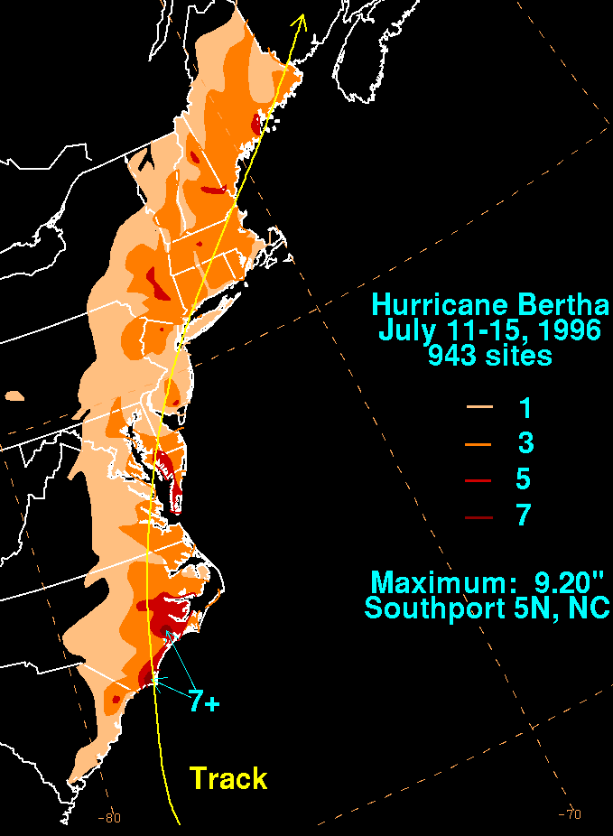 When Bertha made landfall between Wrightsville Beach
and Topsail Beach
, North Carolina
, it brought a storm surge
of 8–10 ft (2.4–3 m) with it. Several fishing piers and marinas were destroyed along with numerous boats. In Onslow County
, 199 structures were destroyed, of which 117 were mobile homes. In New Hanover County
, 1,750 buildings sustained damage. In Kure Beach, near where Bertha made landfall, three homes had their roofs blown off and all structures in the area were damaged. Damages in New Hanover were estimated at $19 million. In Pender County
, 40 homes were undermined by beach erosion and four were destroyed. Damages in the county were estimated at $14.5 million. Agricultural damages in Wayne
, Wilson
, and Johnston
counties were estimated at $21 million.
. At the time, it was the second strongest hurricane to hit the U.S. in July on record, behind a Storm in 1916. It was since pushed down to 4th place, behind Dennis
in 2005 and Dolly
in 2008.
Before affecting the Lesser Antilles as a Category 1 hurricane, Bertha was a very large storm, the size of a Category 4 storm with a tropical gale force exceeding 300 miles wide and a 150 miles wide hurricane windfield.
For North Carolina Bertha was to be the first of two storms to hit within weeks of each other in 1996. The second storm was Fran
, a Category 3 storm.
Leeward Islands
The Leeward Islands are a group of islands in the West Indies. They are the northern islands of the Lesser Antilles chain. As a group they start east of Puerto Rico and reach southward to Dominica. They are situated where the northeastern Caribbean Sea meets the western Atlantic Ocean...
to Atlantic Canada
Atlantic Canada
Atlantic Canada is the region of Canada comprising the four provinces located on the Atlantic coast, excluding Quebec: the three Maritime provinces – New Brunswick, Prince Edward Island, and Nova Scotia – and Newfoundland and Labrador...
. Bertha originated from a tropical wave
Tropical wave
Tropical waves, easterly waves, or tropical easterly waves, also known as African easterly waves in the Atlantic region, are a type of atmospheric trough, an elongated area of relatively low air pressure, oriented north to south, which move from east to west across the tropics causing areas of...
which moved off the eastern coast of Africa
Africa
Africa is the world's second largest and second most populous continent, after Asia. At about 30.2 million km² including adjacent islands, it covers 6% of the Earth's total surface area and 20.4% of the total land area...
in early July. By July 3, an area of low pressure
Low pressure area
A low-pressure area, or "low", is a region where the atmospheric pressure at sea level is below that of surrounding locations. Low-pressure systems form under areas of wind divergence which occur in upper levels of the troposphere. The formation process of a low-pressure area is known as...
developed along the wave. The low gradually developed and was classified a tropical depression on July 5 about midway between the Lesser Antilles
Lesser Antilles
The Lesser Antilles are a long, partly volcanic island arc in the Western Hemisphere. Most of its islands form the eastern boundary of the Caribbean Sea with the Atlantic Ocean, with the remainder located in the southern Caribbean just north of South America...
and Africa. Traveling towards the west-northwest, the depression intensified, reaching hurricane-status on July 7. On July 9, a brief period of rapid intensification
Rapid deepening
Rapid deepening, also known as rapid intensification, is a meteorological condition that occurs when the minimum sea-level atmospheric pressure of a tropical cyclone decreases drastically in a short period of time. The National Weather Service describes rapid deepening as a decrease of...
took place and Bertha reached its peak intensity with winds of 115 mph (185 km/h) while located about 60 mi (95 km) of the Turks and Caicos Islands.
Meteorological history
On July 1, a tropical waveTropical wave
Tropical waves, easterly waves, or tropical easterly waves, also known as African easterly waves in the Atlantic region, are a type of atmospheric trough, an elongated area of relatively low air pressure, oriented north to south, which move from east to west across the tropics causing areas of...
emerged off of the coast of Africa
Africa
Africa is the world's second largest and second most populous continent, after Asia. At about 30.2 million km² including adjacent islands, it covers 6% of the Earth's total surface area and 20.4% of the total land area...
. On July 3, a weak low-level circulation developed while located 500 miles (804.7 km) south of Cape Verde
Cape Verde
The Republic of Cape Verde is an island country, spanning an archipelago of 10 islands located in the central Atlantic Ocean, 570 kilometres off the coast of Western Africa...
. The disturbance moved westward, and on July 5, it strengthened into a tropical depression in the central Atlantic. The depression tracked westward across the open waters of the Atlantic along the western periphery of a subtropical ridge. Later that day, the depression was upgraded to a tropical storm. Over the next three days, Bertha tracked west-northwest while gradual intensification was occurring. On July 7, Tropical Storm Bertha was upgraded to a hurricane with sustained winds of 75 mph (120 km/h) while east of Guadeloupe.
The next day, the center of circulation passed over Antigua
Antigua
Antigua , also known as Waladli, is an island in the West Indies, in the Leeward Islands in the Caribbean region, the main island of the country of Antigua and Barbuda. Antigua means "ancient" in Spanish and was named by Christopher Columbus after an icon in Seville Cathedral, Santa Maria de la...
as Bertha traversed the extreme northeastern portion of the Caribbean Sea
Caribbean Sea
The Caribbean Sea is a sea of the Atlantic Ocean located in the tropics of the Western hemisphere. It is bounded by Mexico and Central America to the west and southwest, to the north by the Greater Antilles, and to the east by the Lesser Antilles....
causing moderate to minor damages. After that, Bertha passed rapidly in the southern portion of Sint Maarten, 10 months after Hurricane Luis
Hurricane Luis
Hurricane Luis was one of the deadliest and most destructive hurricanes of the 1995 Atlantic hurricane season, with maximum sustained winds of 140 mph . The storm was the twelfth tropical storm, sixth hurricane, and second major hurricane of the season...
ravaged the island as a strong category 1 hurricane causing moderate damage to homes,and uprooted trees, sunk boats. Pressure fall to 985 mb and gust over 75 mph (120 km/h) in the Princess Juliana Airport. The storm gradually turned to the northwest on July 9 as maximum sustained winds reached 100 knots (196 km/h) while located 120 miles (193.1 km) northwest of Puerto Rico. Because the highest winds were located on the northeastern portion of the circulation, Puerto Rico received only tropical storm force winds near 50 mph. Forward speed slowed to 15 mph (25 km/h) as Bertha passed within 60 miles (100 km) of the Turks and Caicos, just before reaching its peak intensity.
Continuing its gradual turn, the track soon became north-northwest as the forward speed slowed further to 10 mph (16 km/h) on July 10 and July 11. On July 12, Bertha made landfall between Wrightsville Beach
Wrightsville Beach, North Carolina
Wrightsville Beach is a town in New Hanover County, North Carolina, United States. Wrightsville Beach is just east of Wilmington and is part of the Wilmington Metropolitan Statistical Area. The population was 2,593 at the 2000 census...
and Topsail Beach
Topsail Beach, North Carolina
Topsail Beach is a town in Pender County, North Carolina, United States. The population was 581 at the 2008 census. It is part of the Wilmington Metropolitan Statistical Area.-Geography:Topsail Beach is located at ....
. Bertha lost hurricane intensity just after landfall. It then accelerated to the northeast along the East Coast of the United States
East Coast of the United States
The East Coast of the United States, also known as the Eastern Seaboard, refers to the easternmost coastal states in the United States, which touch the Atlantic Ocean and stretch up to Canada. The term includes the U.S...
, producing winds of up to 60 mph (100 km/h). It moved north, and lost all of its tropical characteristics by July 18.
U.S. Virgin Islands
In the United States Virgin IslandsUnited States Virgin Islands
The Virgin Islands of the United States are a group of islands in the Caribbean that are an insular area of the United States. The islands are geographically part of the Virgin Islands archipelago and are located in the Leeward Islands of the Lesser Antilles.The U.S...
, rainfall from Bertha peaked at 3.28 in (83.3 mm) on St. Thomas. Winds from the storm were reported to be sustained at 85 mph (140 km/h) with an unofficial reading of 100 mph (155 km/h). The Federal Emergency Management Agency
Federal Emergency Management Agency
The Federal Emergency Management Agency is an agency of the United States Department of Homeland Security, initially created by Presidential Reorganization Plan No. 1 of 1978 and implemented by two Executive Orders...
(FEMA) reported that 1,415 homes were damaged, of which 43 lost their roofs. Two boats were destroyed, five were grounded, and nine others washed ashore. One injury occurred in Coral Bay as a man rode out the storm in his sailboat. Damages from the storm were estimated at $7.5 million (1996 USD
United States dollar
The United States dollar , also referred to as the American dollar, is the official currency of the United States of America. It is divided into 100 smaller units called cents or pennies....
).
Puerto Rico
The maximum rainfall reported in association with Bertha was 8.17 inches (207.5 mm) along the Rio IcacosRío Icacos
-See also:*List of rivers of Puerto Rico-References:*USGS Hydrologic Unit Map – Caribbean Region *...
in Naguabo. Wind reports from the Roosevelt Roads Naval Base on July 8 indicated a maximum sustained wind of 44 mi/h. Although heavy rain did occur, there was no widespread or significant inland flooding reported. There were, however, several reports of swollen rivers which caused some minor flood
Flood
A flood is an overflow of an expanse of water that submerges land. The EU Floods directive defines a flood as a temporary covering by water of land not normally covered by water...
ing of low lying and urban areas; coastal flooding was reported from Carolina to Loiza along road 187. In addition, recorded rainfall at the LMM Airport was 1.56 inches (39.6 mm).
One death is attributed to Hurricane Bertha; a tourist drowned while surfing in high seas at the Playa Azul beach area in Luquillo. Two other deaths occurred indirectly as a result of Bertha, when two people were killed in a traffic accident while tropical storm force winds were occurring. The hardest hit area was the municipality of Culebra
Culebra, Puerto Rico
Isla Culebra is an island-municipality of Puerto Rico originally called Isla Pasaje and Isla de San Ildefonso. It is located approximately east of the Puerto Rican mainland, west of St. Thomas and north of Vieques. Culebra is spread over 5 wards and Culebra Pueblo...
, where most of the damage was to agriculture and commerce. However, because damages were minimum, none of the municipalities were declared disaster areas. The Housing Department
Housing Department
Housing Department is a department of Hong Kong Government, managing public housing estates that were built by Hong Kong Housing Authority in Hong Kong. It reports to the Housing, Planning and Lands Bureau, which is headed by the Secretary for Housing, Planning and Lands.-See also:* Hong Kong...
estimated damages to homes at $410,000 (1996 USD). The agricultural damages were estimated at $6 million (1996 USD) in the San Juan
San Juan, Puerto Rico
San Juan , officially Municipio de la Ciudad Capital San Juan Bautista , is the capital and most populous municipality in Puerto Rico, an unincorporated territory of the United States. As of the 2010 census, it had a population of 395,326 making it the 46th-largest city under the jurisdiction of...
, Caguas, and Ponce Regions, mostly wind damage to coffee, plantain, and banana crops. In all, it is estimated that $7.5 million (1996 USD) in damage in Puerto Rico were attributed to Bertha.
Greater Antilles and Bahamas
The Bahamas and the north coast of the Dominican RepublicDominican Republic
The Dominican Republic is a nation on the island of La Hispaniola, part of the Greater Antilles archipelago in the Caribbean region. The western third of the island is occupied by the nation of Haiti, making Hispaniola one of two Caribbean islands that are shared by two countries...
likely suffered light damage, though no damage figures are available for either.
Eastern United States
Wrightsville Beach, North Carolina
Wrightsville Beach is a town in New Hanover County, North Carolina, United States. Wrightsville Beach is just east of Wilmington and is part of the Wilmington Metropolitan Statistical Area. The population was 2,593 at the 2000 census...
and Topsail Beach
Topsail Beach, North Carolina
Topsail Beach is a town in Pender County, North Carolina, United States. The population was 581 at the 2008 census. It is part of the Wilmington Metropolitan Statistical Area.-Geography:Topsail Beach is located at ....
, North Carolina
North Carolina
North Carolina is a state located in the southeastern United States. The state borders South Carolina and Georgia to the south, Tennessee to the west and Virginia to the north. North Carolina contains 100 counties. Its capital is Raleigh, and its largest city is Charlotte...
, it brought a storm surge
Storm surge
A storm surge is an offshore rise of water associated with a low pressure weather system, typically tropical cyclones and strong extratropical cyclones. Storm surges are caused primarily by high winds pushing on the ocean's surface. The wind causes the water to pile up higher than the ordinary sea...
of 8–10 ft (2.4–3 m) with it. Several fishing piers and marinas were destroyed along with numerous boats. In Onslow County
Onslow County, North Carolina
-Demographics:As of the census of 2000, there were 150,355 people, 48,122 households, and 36,572 families residing in the county. The population density was 196 people per square mile . There were 55,726 housing units at an average density of 73 per square mile...
, 199 structures were destroyed, of which 117 were mobile homes. In New Hanover County
New Hanover County, North Carolina
-Demographics:As of the census of 2000, there were 160,307 people, 68,183 households, and 41,591 families residing in the county. The population density was 806 people per square mile . There were 79,616 housing units at an average density of 400 per square mile...
, 1,750 buildings sustained damage. In Kure Beach, near where Bertha made landfall, three homes had their roofs blown off and all structures in the area were damaged. Damages in New Hanover were estimated at $19 million. In Pender County
Pender County, North Carolina
-Demographics:As of the census of 2000, there were 41,082 people, 16,054 households, and 11,719 families residing in the county. The population density was 47 people per square mile . There were 20,798 housing units at an average density of 24 per square mile...
, 40 homes were undermined by beach erosion and four were destroyed. Damages in the county were estimated at $14.5 million. Agricultural damages in Wayne
Wayne County, North Carolina
- Cities and towns :*Brogden*Dudley*Elroy*Eureka*Fremont*Goldsboro*Mar-Mac*Mount Olive*Pikeville*Rosewood*Seven Springs*Walnut Creek*Grantham-Geography:According to the U.S...
, Wilson
Wilson County, North Carolina
-Demographics:As of the census of 2006, there 73,814 people, 28,613 households, and 19,771 families residing in the county. The population density was 199 people per square mile . There were 30,729 housing units at an average density of 83 per square mile...
, and Johnston
Johnston County, North Carolina
-Major highways:* Interstate 40* Interstate 95* U.S. Highway 70* U.S. Highway 301* U.S. Highway 701-Demographics:As of the census of 2000, there were 121,965 people, 46,595 households, and 33,688 families residing in the county. The population density was 154 people per square mile . There were...
counties were estimated at $21 million.
Records
Bertha was one of only ten major hurricanes recorded before August on record in the Atlantic basin, and was one of just six in July, as well as the first major hurricane in July since the 1926 seasonNassau Hurricane of 1926
The Nassau Hurricane of 1926, also known as the Bahamas-Florida Hurricane of July 1926 and Hurricane San Liborio, was a destructive Category 4 hurricane that affected the Bahamas at peak intensity...
. At the time, it was the second strongest hurricane to hit the U.S. in July on record, behind a Storm in 1916. It was since pushed down to 4th place, behind Dennis
Hurricane Dennis
Hurricane Dennis was an early-forming major hurricane in the Caribbean and Gulf of Mexico during the very active 2005 Atlantic hurricane season. Dennis was the fourth named storm, second hurricane, and first major hurricane of the season...
in 2005 and Dolly
Hurricane Dolly (2008)
Hurricane Dolly was a tropical cyclone that made landfall in extreme southern Texas in July 2008. Dolly was the fourth tropical cyclone and second hurricane to form during the 2008 Atlantic hurricane season. It was the first U.S. landfalling hurricane of the 2008 season. Dolly developed on July 20...
in 2008.
Before affecting the Lesser Antilles as a Category 1 hurricane, Bertha was a very large storm, the size of a Category 4 storm with a tropical gale force exceeding 300 miles wide and a 150 miles wide hurricane windfield.
For North Carolina Bertha was to be the first of two storms to hit within weeks of each other in 1996. The second storm was Fran
Hurricane Fran
Hurricane Fran was a powerful Cape Verde-type hurricane of the 1996 Atlantic hurricane season that made landfall near Cape Fear in North Carolina at Category 3 strength. Throughout the eastern United States, early statistics on Fran reported 27 deaths and $3.2 billion in damage...
, a Category 3 storm.
See also
- Other storms of the same nameHurricane Bertha (disambiguation)The name Bertha has been used for six tropical cyclones in the Atlantic Ocean.* 1957's Tropical Storm Bertha: A moderate Tropical Storm that threatened areas devastated by Hurricane Audrey two months earlier, but did not become a hurricane and caused only minor damage.* 1984's Tropical Storm...
- List of North Carolina hurricanes (1980–present)
- List of New Jersey hurricanes