
1928 Okeechobee Hurricane
Encyclopedia
The Okeechobee hurricane, or San Felipe Segundo hurricane, was a deadly hurricane
that struck the Leeward Islands
, Puerto Rico, the Bahamas, and Florida in September of the 1928 Atlantic hurricane season
. It was the second recorded hurricane to reach Category 5 status on the Saffir-Simpson Hurricane Scale
in the Atlantic basin
after the 1924 Cuba hurricane
; as of 2010, it remained the only recorded hurricane to strike Puerto Rico at Category 5 strength, and one of the ten most intense ever recorded to make landfall in the United States.
The hurricane caused devastation throughout its path. As many as 1,200 people were killed in Guadeloupe
. The storm directly struck Puerto Rico at peak strength, killing at least 300 and leaving hundreds of thousands homeless. In South Florida at least 2,500 were killed when a storm surge from Lake Okeechobee
breached the dike surrounding the lake, flooding an area covering hundreds of square miles. In total, the hurricane killed at least 4,078 people and caused around US$ ($ USD) in damages over the course of its path.
, hurricane analysis in the 1990s determined the storm likely formed four days prior between Cape Verde
and the coast of Africa.
As the storm neared the Caribbean
, it was already a Category 3 hurricane. On September 12 it passed over Guadeloupe and then south of the other Leeward Islands; Guadeloupe reported a pressure of 27.76 inHg (940 mbar), and a ship just south of St. Croix in the United States Virgin Islands
reported it as an even stronger storm with a pressure of 27.50 inHg (931 mbar). On the 13th the storm struck Puerto Rico directly as a Category 5 hurricane, allegedly packing winds of 160 mph (260 km/h); reliable reports from San Juan
placed the wind speed at 125 knots (145 mph, 230 km/h), and a report from Guayama
placed the pressure at 27.65 inHg (936 mbar). The 160 mph (260 km/h) wind measurement from Puerto Rico was taken by a cup anemometer
in San Juan
, 30 miles (50 km) north of the storm's center, which measured 160 mph (260 km/h) sustained winds three hours before the peak wind speed was reached; however, the instrument was destroyed soon after and could not be calibrated. This unverified reading was the strongest wind measurement ever reported for an Atlantic hurricane up until that time; not until Hurricane Dog
of 1950 were stronger winds officially measured in an Atlantic storm, although some unmeasured storms like the 1935 Labor Day Hurricane
may have been stronger. Because of this measurement, the Okeechobee storm was the first hurricane, in the Atlantic basin known to have reached Category 5 intensity, although in 2009, it was found that the 1924 Cuba Hurricane had reached Category 5 as well; although it is virtually certain that earlier hurricanes had achieved this strength (a likely candidate is the Great Havana Hurricane of 1846
), none had ever had their winds or pressure recorded properly.
The hurricane was also extremely large as it crossed Puerto Rico. Hurricane-force winds were measured in Guayama
for 18 hours; since the storm is estimated to have been moving at 13 mph (21 km/h), the diameter of the storm's hurricane winds was estimated very roughly to be 234 miles (376 km). After leaving the Caribbean, the hurricane moved across the Bahamas as a strong Category 4 hurricane. It continued to the west-northwest, and made landfall in southern Florida on the evening of September 16 (or early on September 17 Universal Time
). Initially, Richard Gray of the U.S. Weather Bureau was optimistic that the storm would spare the south Florida region. Atmospheric pressure at landfall was measured at 929 mbar (hPa), and maximum sustained winds were near 150 mph (240 km/h). The eye passed ashore in Palm Beach County
near West Palm Beach
, then moved directly over Lake Okeechobee. Peak gusts were estimated near 160 mph (260 km/h) at Canal Point, Florida
. The hurricane's path turned northeast as it crossed Florida, taking it across northern Florida, eastern Georgia
, and the Carolinas on September 19. It then moved inland and merged with a low-pressure system around Toronto on the 20th.
The hurricane moved directly over the Leeward Islands in the Caribbean, strengthening as it did so. On the island of Dominica
winds were clocked at 24 mph (39 km/h); there were no reports of damages. In Martinique
, even further south of the storm's path, there were three fatalities. Guadeloupe received a near-direct hit from the storm, apparently with little warning; the death toll there was 600–1200, and damage reports relayed through Paris indicated "great destruction" on the island.
Montserrat
, just north of the storm's center, was warned in advance of the storm but still suffered £150,000 (1928 UKP) in damages and 42 deaths; Plymouth
and Salem were devastated and crop losses caused near-starvation conditions before relief could arrive. The storm passed to the south of the islands of St. Kitts and St. Croix, which suffered heavy damages to property and crops but no reported fatalities. Nevis
did report three deaths due to the storm, though. Damage reports from elsewhere in the Leeward Islands are not available.
killed approximately 3,000 people.
The storm was named the San Felipe II Hurricane because the eye of the cyclone made landfall on the Christian
feast day of Saint Philip. It was named "Segundo", Spanish for "the Second", because of another destructive "Hurricane San Felipe
" which struck Puerto Rico on that same day in 1876. Since European arrival in the Americas in 1492 all storms and hurricanes were named after the name of the saint of the day the storm hit Puerto Rico. In 1953 that the United States started naming hurricanes by female names until 1978 when both gender names began to be used. Yet it was only in 1960 that hurricanes stopped being officially named after Saints.
San Felipe II is officially classified as Puerto Rico's biggest, worst, and most devastating hurricane to ever have impacted the island. Even though it was the worst hurricane to hit the island, others such as the San Ciriaco Hurricane caused more deaths. The first warning the Island received was by the steamship Commack on latitude 17° north and longitude 48° West. San Felipe entered the island early in the morning of Thursday September 13, with its eye close to Guayama and it traversed the island in a north-west direction, leaving between the towns of Aguadilla and Isabela
. The eye of the hurricane made its Puerto Rico crossing in eight hours, moving at about 13 mi/h. In Guayama, located in south eastern Puerto Rico, the lowest recording of the storm was taken; 27.5 inHg (931.3 mbar) at 2:30 p.m.
In the island there was no building that was not affected. Some sugar mills ("Centrales") that had cost millions of dollars to build were reduced to rubble. Reports say that 24,728 homes were completely destroyed and 192,444 were partially destroyed. Most of the sugarcane
fields were flooded, thus losing the year's crops. Half of the coffee plants and half of the shade tree
s that covered these were destroyed; almost all of the coffee harvest was lost. The coffee industry would take years to recover since coffee needs shade trees to grow. The tobacco
farms also had great losses. After this hurricane, Puerto Rico never regained its position as a coffee exporter
.
Communications were impacted by fallen trees, landslides, and debilitated bridges. Of the school buildings 770 were destroyed or debilitated. According to some estimates of the day, excluding personal losses, the damages reached ($ USD)) and over 500,000 people were left homeless.
as a strong Category 4 hurricane, again causing very heavy damage. According to a firsthand account from the island, it was the worst storm in memory to strike the area. As in Puerto Rico, however, authorities in the Bahamas were aware of the hurricane's passage well ahead of time, and preparations minimized the loss of life in the islands. The only report of fatalities was from a sloop
lost at sea in the vicinity of Ambergris Cay with 18 on board.
, well south of the point of landfall, escaped with very little damage; Hollywood
and Fort Lauderdale
suffered only slight damages. In Fort Lauderdale, numerous power lines and telephone wires were downed. Northward, from Pompano Beach
to Jupiter
, buildings suffered serious damage from the heavy winds and 10 ft (3 m) storm surge, which was heaviest in the vicinity of Palm Beach
; total coastal damages were estimated as "several million" dollars. In West Palm Beach, more than 1,711 homes were destroyed, while the Jupiter Inlet Light
house's mortar was reportedly "squeezed ...like toothpaste" between the bricks during the storm, swaying the tower 17 inches (43.2 cm) off the base. Because of well-issued hurricane warnings, residents were prepared for the storm, and the number of lives lost in the coastal Palm Beach area was only 26.
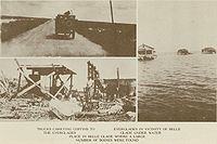 Inland, the hurricane wreaked much more widespread destruction along the more heavily populated coast of Lake Okeechobee. Residents had been warned to evacuate the low ground earlier in the day, but after the hurricane did not arrive on schedule, many thought it had missed and returned to their homes. When the worst of the storm crossed the lake—with winds measured on the ground at around 140 mph (225 km/h)—the south-blowing wind caused a storm surge
to overflow the small dike that had been built at the south end of the lake. The resulting flood covered an area of hundreds of square miles with water that in some places was over 20 ft (6 m) deep. Houses were floated off of their foundations and dashed to pieces against any obstacle they encountered. However, for the few families who resided on Torry Island, the breached dike saved their lives. The rising flood waters forced most families on to the roofs of their houses in an act of desperation. The dike's failure drained the lake and those on the island survived. Among the surviving on Torry Island were the families of Jesse Lee and Gus Cromartie. Meanwhile, most survivors and bodies were washed out into the Everglades
where many of the bodies were never found. As the rear eyewall passed over the area, the flood reversed itself, breaking the dikes along the northern coast of the lake and causing a similar but smaller flood.
 Floodwaters persisted for several weeks, greatly impeding attempts to clean up the devastation. Burial services were quickly overwhelmed, and many of the bodies were placed into mass graves. Around 75% of the fatalities were migrant farm workers, making identification of both dead and missing bodies very difficult; as a result of this, the count of the dead is not very accurate. The Red Cross estimated the number of fatalities as 1,836, which was taken as the official count by the National Weather Service
for many years (and exactly equal to the official count for Hurricane Katrina
). Older sources usually list 3,411 as the hurricane's total count of fatalities, including the Caribbean. However, in 2003 the U.S. death count was revised as "at least" 2,500, making the Okeechobee hurricane the second-deadliest natural disaster in United States history behind the Galveston Hurricane of 1900
. A mass grave at the Port Mayaca Cemetery east of Port Mayaca contains the bodies of 1,600 victims of the hurricane.
Thousands of people were left homeless in Florida; property damage was estimated at $25 million ($). It is estimated if a similar storm were to strike as of the year 2003, it would cause $18.7 billion in damages. The cyclone remains one of three Atlantic hurricanes to strike the southern mainland of Florida with a central pressure below 940 mbar (27.76 inHg), the others being the 1926 Miami hurricane
and Hurricane Andrew
of 1992
.
and brought near-hurricane-force winds and a 7 foot (2.1 m) storm surge to the Norfolk
area. Nonetheless, most sources agree that the hurricane caused only minimal damage in these areas.
's novel Their Eyes Were Watching God
.
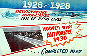 To prevent a recurrence of disasters like this one and the Great Miami Hurricane of 1926, the Florida State Legislature created the Okeechobee Flood Control District, which was authorized to cooperate with the U.S. Army Corps of Engineers in flood control undertakings. After a personal inspection of the area by President Herbert Hoover
, the Corps drafted a new plan which provided for the construction of floodway channels, control gates, and major levees along Lake Okeechobee's shores. A long term system was designed for the purpose of flood control, water conservation, prevention of saltwater intrusion, and preservation of fish and wildlife populations. One of the solutions was the construction of the Herbert Hoover Dike
. Today, concerns related to the dike's stability have grown in response to studies indicating long term problems with "piping" and erosion
. Leaks have been reported after several heavy rain events. Proposed solutions to the dike's problems have included the construction of a seepage
berm
on the landward side of the dike, with the first stage costing approximately $67 million (USD
).
Tropical cyclone
A tropical cyclone is a storm system characterized by a large low-pressure center and numerous thunderstorms that produce strong winds and heavy rain. Tropical cyclones strengthen when water evaporated from the ocean is released as the saturated air rises, resulting in condensation of water vapor...
that struck the Leeward Islands
Leeward Islands
The Leeward Islands are a group of islands in the West Indies. They are the northern islands of the Lesser Antilles chain. As a group they start east of Puerto Rico and reach southward to Dominica. They are situated where the northeastern Caribbean Sea meets the western Atlantic Ocean...
, Puerto Rico, the Bahamas, and Florida in September of the 1928 Atlantic hurricane season
1928 Atlantic hurricane season
The 1928 Atlantic hurricane season ran through the summer and the first half of fall in 1928. The season was not active, but eventful. Six tropical cyclones formed during the season. Four of those became hurricanes. Only one became a major hurricane, which was also a Category 5 hurricane.-Hurricane...
. It was the second recorded hurricane to reach Category 5 status on the Saffir-Simpson Hurricane Scale
Saffir-Simpson Hurricane Scale
The Saffir–Simpson Hurricane Scale , or the Saffir–Simpson Hurricane Wind Scale , classifies hurricanes — Western Hemisphere tropical cyclones that exceed the intensities of tropical depressions and tropical storms — into five categories distinguished by the intensities of their sustained winds...
in the Atlantic basin
Atlantic Basin
The Atlantic Basin is the Atlantic Ocean.Atlantic Basin may also refer to:* Atlantic Basin Iron Works, an ironworks that operated in Brooklyn, New York, in the early to mid-20th century...
after the 1924 Cuba hurricane
1924 Cuba hurricane
The 1924 Cuba hurricane is the earliest officially classified Category 5 Atlantic hurricane on the Saffir–Simpson scale. It formed on October 14 in the western Caribbean Sea, slowly organizing as it tracked northwestward. By October 16, it attained hurricane status to the east of the...
; as of 2010, it remained the only recorded hurricane to strike Puerto Rico at Category 5 strength, and one of the ten most intense ever recorded to make landfall in the United States.
The hurricane caused devastation throughout its path. As many as 1,200 people were killed in Guadeloupe
Guadeloupe
Guadeloupe is an archipelago located in the Leeward Islands, in the Lesser Antilles, with a land area of 1,628 square kilometres and a population of 400,000. It is the first overseas region of France, consisting of a single overseas department. As with the other overseas departments, Guadeloupe...
. The storm directly struck Puerto Rico at peak strength, killing at least 300 and leaving hundreds of thousands homeless. In South Florida at least 2,500 were killed when a storm surge from Lake Okeechobee
Lake Okeechobee
Lake Okeechobee , locally referred to as The Lake or The Big O, is the largest freshwater lake in the state of Florida. It is the seventh largest freshwater lake in the United States and the second largest freshwater lake contained entirely within the lower 48 states...
breached the dike surrounding the lake, flooding an area covering hundreds of square miles. In total, the hurricane killed at least 4,078 people and caused around US$ ($ USD) in damages over the course of its path.
Meteorological history
The storm was first observed 900 miles (1450 km) to the east of Guadeloupe on September 10 by the S.S. Commack. At the time, this was the most easterly report of a tropical cyclone ever received through ship's radio. A Cape Verde-type hurricaneCape Verde-type hurricane
A Cape Verde-type hurricane is an Atlantic hurricane that develops near the Cape Verde islands, off the west coast of Africa. The average hurricane season has about two Cape Verde-type hurricanes, which are usually the largest and most intense storms of the season because they often have plenty of...
, hurricane analysis in the 1990s determined the storm likely formed four days prior between Cape Verde
Cape Verde
The Republic of Cape Verde is an island country, spanning an archipelago of 10 islands located in the central Atlantic Ocean, 570 kilometres off the coast of Western Africa...
and the coast of Africa.
As the storm neared the Caribbean
Caribbean
The Caribbean is a crescent-shaped group of islands more than 2,000 miles long separating the Gulf of Mexico and the Caribbean Sea, to the west and south, from the Atlantic Ocean, to the east and north...
, it was already a Category 3 hurricane. On September 12 it passed over Guadeloupe and then south of the other Leeward Islands; Guadeloupe reported a pressure of 27.76 inHg (940 mbar), and a ship just south of St. Croix in the United States Virgin Islands
United States Virgin Islands
The Virgin Islands of the United States are a group of islands in the Caribbean that are an insular area of the United States. The islands are geographically part of the Virgin Islands archipelago and are located in the Leeward Islands of the Lesser Antilles.The U.S...
reported it as an even stronger storm with a pressure of 27.50 inHg (931 mbar). On the 13th the storm struck Puerto Rico directly as a Category 5 hurricane, allegedly packing winds of 160 mph (260 km/h); reliable reports from San Juan
San Juan, Puerto Rico
San Juan , officially Municipio de la Ciudad Capital San Juan Bautista , is the capital and most populous municipality in Puerto Rico, an unincorporated territory of the United States. As of the 2010 census, it had a population of 395,326 making it the 46th-largest city under the jurisdiction of...
placed the wind speed at 125 knots (145 mph, 230 km/h), and a report from Guayama
Guayama, Puerto Rico
Guayama is a municipality of Puerto Rico founded on January 29, 1736 and located on the Southern Coastal Valley region, bordering the Caribbean, south of Cayey; east of Salinas; and west of Patillas and Arroyo. Guayama is spread over 9 wards and Guayama Pueblo...
placed the pressure at 27.65 inHg (936 mbar). The 160 mph (260 km/h) wind measurement from Puerto Rico was taken by a cup anemometer
Anemometer
An anemometer is a device for measuring wind speed, and is a common weather station instrument. The term is derived from the Greek word anemos, meaning wind, and is used to describe any airspeed measurement instrument used in meteorology or aerodynamics...
in San Juan
San Juan, Puerto Rico
San Juan , officially Municipio de la Ciudad Capital San Juan Bautista , is the capital and most populous municipality in Puerto Rico, an unincorporated territory of the United States. As of the 2010 census, it had a population of 395,326 making it the 46th-largest city under the jurisdiction of...
, 30 miles (50 km) north of the storm's center, which measured 160 mph (260 km/h) sustained winds three hours before the peak wind speed was reached; however, the instrument was destroyed soon after and could not be calibrated. This unverified reading was the strongest wind measurement ever reported for an Atlantic hurricane up until that time; not until Hurricane Dog
Hurricane Dog (1950)
Hurricane Dog was the most intense hurricane in the 1950 Atlantic hurricane season. The fourth named storm of the season, Dog developed on August 30 to the east of Antigua; after passing through the northern Lesser Antilles, it turned to the north and intensified into a Category 5 hurricane...
of 1950 were stronger winds officially measured in an Atlantic storm, although some unmeasured storms like the 1935 Labor Day Hurricane
Labor Day Hurricane of 1935
The 1935 Labor Day Hurricane was the strongest tropical cyclone of the 1935 Atlantic hurricane season, and one of the most intense hurricanes to make landfall in the United States in recorded history...
may have been stronger. Because of this measurement, the Okeechobee storm was the first hurricane, in the Atlantic basin known to have reached Category 5 intensity, although in 2009, it was found that the 1924 Cuba Hurricane had reached Category 5 as well; although it is virtually certain that earlier hurricanes had achieved this strength (a likely candidate is the Great Havana Hurricane of 1846
Great Havana Hurricane of 1846
The Great Havana Hurricane of 1846 was a powerful late season hurricane that caused extensive damage and up to 255 deaths as it moved across Cuba, Florida, and the eastern United States before dissipating over the Canadian Maritimes.-Meteorological history:...
), none had ever had their winds or pressure recorded properly.
The hurricane was also extremely large as it crossed Puerto Rico. Hurricane-force winds were measured in Guayama
Guayama, Puerto Rico
Guayama is a municipality of Puerto Rico founded on January 29, 1736 and located on the Southern Coastal Valley region, bordering the Caribbean, south of Cayey; east of Salinas; and west of Patillas and Arroyo. Guayama is spread over 9 wards and Guayama Pueblo...
for 18 hours; since the storm is estimated to have been moving at 13 mph (21 km/h), the diameter of the storm's hurricane winds was estimated very roughly to be 234 miles (376 km). After leaving the Caribbean, the hurricane moved across the Bahamas as a strong Category 4 hurricane. It continued to the west-northwest, and made landfall in southern Florida on the evening of September 16 (or early on September 17 Universal Time
Universal Time
Universal Time is a time scale based on the rotation of the Earth. It is a modern continuation of Greenwich Mean Time , i.e., the mean solar time on the Prime Meridian at Greenwich, and GMT is sometimes used loosely as a synonym for UTC...
). Initially, Richard Gray of the U.S. Weather Bureau was optimistic that the storm would spare the south Florida region. Atmospheric pressure at landfall was measured at 929 mbar (hPa), and maximum sustained winds were near 150 mph (240 km/h). The eye passed ashore in Palm Beach County
Palm Beach County, Florida
Palm Beach County is the largest county in the state of Florida in total area, and third in population. As of 2010, the county's estimated population was 1,320,134, making it the twenty-eighth most populous in the United States...
near West Palm Beach
West Palm Beach, Florida
West Palm Beach, is a city located on the Atlantic coast in southeastern Florida and is the most populous city in and county seat of Palm Beach County, the third most populous county in Florida with a 2010 population of 1,320,134. The city is also the oldest incorporated municipality in South Florida...
, then moved directly over Lake Okeechobee. Peak gusts were estimated near 160 mph (260 km/h) at Canal Point, Florida
Canal Point, Florida
The unincorporated community of Canal Point is a census-designated place in Palm Beach County, Florida, United States. The population was 525 at the 2000 census.-Geography:Canal Point is located at ....
. The hurricane's path turned northeast as it crossed Florida, taking it across northern Florida, eastern Georgia
Georgia (U.S. state)
Georgia is a state located in the southeastern United States. It was established in 1732, the last of the original Thirteen Colonies. The state is named after King George II of Great Britain. Georgia was the fourth state to ratify the United States Constitution, on January 2, 1788...
, and the Carolinas on September 19. It then moved inland and merged with a low-pressure system around Toronto on the 20th.
Leeward Islands
| Storm Deaths by Region | |||
|---|---|---|---|
| Region | Deaths | Locale | Deaths |
| Caribbean and Bahamas |
1575 | Martinique Martinique Martinique is an island in the eastern Caribbean Sea, with a land area of . Like Guadeloupe, it is an overseas region of France, consisting of a single overseas department. To the northwest lies Dominica, to the south St Lucia, and to the southeast Barbados... |
3 |
| Guadeloupe Guadeloupe Guadeloupe is an archipelago located in the Leeward Islands, in the Lesser Antilles, with a land area of 1,628 square kilometres and a population of 400,000. It is the first overseas region of France, consisting of a single overseas department. As with the other overseas departments, Guadeloupe... |
600–1200 | ||
| Montserrat Montserrat Montserrat is a British overseas territory located in the Leeward Islands, part of the chain of islands called the Lesser Antilles in the West Indies. This island measures approximately long and wide, giving of coastline... |
42 | ||
| Nevis Nevis Nevis is an island in the Caribbean Sea, located near the northern end of the Lesser Antilles archipelago, about 350 km east-southeast of Puerto Rico and 80 km west of Antigua. The 93 km² island is part of the inner arc of the Leeward Islands chain of the West Indies... |
3 | ||
| Puerto Rico | 312 | ||
| Bahamas | 18 | ||
| United States | 2500+ | Florida | 2500+ |
| Total | 4078+ | ||
The hurricane moved directly over the Leeward Islands in the Caribbean, strengthening as it did so. On the island of Dominica
Dominica
Dominica , officially the Commonwealth of Dominica, is an island nation in the Lesser Antilles region of the Caribbean Sea, south-southeast of Guadeloupe and northwest of Martinique. Its size is and the highest point in the country is Morne Diablotins, which has an elevation of . The Commonwealth...
winds were clocked at 24 mph (39 km/h); there were no reports of damages. In Martinique
Martinique
Martinique is an island in the eastern Caribbean Sea, with a land area of . Like Guadeloupe, it is an overseas region of France, consisting of a single overseas department. To the northwest lies Dominica, to the south St Lucia, and to the southeast Barbados...
, even further south of the storm's path, there were three fatalities. Guadeloupe received a near-direct hit from the storm, apparently with little warning; the death toll there was 600–1200, and damage reports relayed through Paris indicated "great destruction" on the island.
Montserrat
Montserrat
Montserrat is a British overseas territory located in the Leeward Islands, part of the chain of islands called the Lesser Antilles in the West Indies. This island measures approximately long and wide, giving of coastline...
, just north of the storm's center, was warned in advance of the storm but still suffered £150,000 (1928 UKP) in damages and 42 deaths; Plymouth
Plymouth, Montserrat
Plymouth is the de jure capital of the island of Montserrat, an overseas territory of the United Kingdom located in the Leeward Island chain of the Lesser Antilles, West Indies. The town was overwhelmed by volcanic eruptions starting in the 1990s and was abandoned...
and Salem were devastated and crop losses caused near-starvation conditions before relief could arrive. The storm passed to the south of the islands of St. Kitts and St. Croix, which suffered heavy damages to property and crops but no reported fatalities. Nevis
Nevis
Nevis is an island in the Caribbean Sea, located near the northern end of the Lesser Antilles archipelago, about 350 km east-southeast of Puerto Rico and 80 km west of Antigua. The 93 km² island is part of the inner arc of the Leeward Islands chain of the West Indies...
did report three deaths due to the storm, though. Damage reports from elsewhere in the Leeward Islands are not available.
Puerto Rico
The island of Puerto Rico received the worst of the storm's winds when the hurricane moved directly across the island at Category 5 strength. The island knew of the storm's approach well ahead of time; by about 36 hours in advance all police districts were warned and radio broadcasts provided constant warnings to ships. Effective preparation is credited for the relatively low death toll of 312, and not a single ship was lost at sea in the vicinity of Puerto Rico. By comparison, the weaker 1899 Hurricane San Ciriaco1899 Hurricane San Ciriaco
1899 San Ciriaco hurricane, also known as the 1899 Puerto Rico Hurricane, was the longest-lived Atlantic hurricane and the eleventh deadliest tropical cyclone in the basin. It was an intense and long-lived Atlantic Cape Verde-type hurricane which crossed Puerto Rico over the two day period August 8...
killed approximately 3,000 people.
The storm was named the San Felipe II Hurricane because the eye of the cyclone made landfall on the Christian
Christian
A Christian is a person who adheres to Christianity, an Abrahamic, monotheistic religion based on the life and teachings of Jesus of Nazareth as recorded in the Canonical gospels and the letters of the New Testament...
feast day of Saint Philip. It was named "Segundo", Spanish for "the Second", because of another destructive "Hurricane San Felipe
San Felipe Hurricane
San Felipe Hurricane may refer to:* 1876 San Felipe Hurricane, Category 3 hurricane which caused at least 19 deaths in Puerto Rico* 1928 Okeechobee hurricane, also called the "San Felipe Segundo Hurricane" or "San Felipe II Hurricane", Category 5 hurricane which killed thousands in the Caribbean...
" which struck Puerto Rico on that same day in 1876. Since European arrival in the Americas in 1492 all storms and hurricanes were named after the name of the saint of the day the storm hit Puerto Rico. In 1953 that the United States started naming hurricanes by female names until 1978 when both gender names began to be used. Yet it was only in 1960 that hurricanes stopped being officially named after Saints.
San Felipe II is officially classified as Puerto Rico's biggest, worst, and most devastating hurricane to ever have impacted the island. Even though it was the worst hurricane to hit the island, others such as the San Ciriaco Hurricane caused more deaths. The first warning the Island received was by the steamship Commack on latitude 17° north and longitude 48° West. San Felipe entered the island early in the morning of Thursday September 13, with its eye close to Guayama and it traversed the island in a north-west direction, leaving between the towns of Aguadilla and Isabela
Isabela, Puerto Rico
Isabela is a municipality of Puerto Rico located in the north-western region of the island, north of San Sebastián; west of Quebradillas; and east of Aguadilla and Moca. Isabela is spread over 13 wards and Isabela Pueblo...
. The eye of the hurricane made its Puerto Rico crossing in eight hours, moving at about 13 mi/h. In Guayama, located in south eastern Puerto Rico, the lowest recording of the storm was taken; 27.5 inHg (931.3 mbar) at 2:30 p.m.
Rainfall
The rain on the 13 and 14 of September 1928, are the record holders for the maximum of rainfall associated with a hurricane in Puerto Rico in a period of forty-eight hours. In those regions where precipitation is more common place, as in Adjuntas in the Cordillera Central and in the Sierra de Luquillo, the rain was over 25 inches (635 mm), with 29.6 inches (751.8 mm) recorded in Adjuntas.Wind
The anemometer located in Puerta de Tierra lost one of its cups at 11:44 a.m. on the September 13, just when it had registered a maximum speed of 150 miles (241.4 km) per hour, a speed that was sustained for five consecutive minutes. Previously the same instrument had measured 160 miles (257.5 km) per hour for one minute. The city of San Juan was 30 miles (48.3 km) away from the eye of San Felipe when those measurements were recorded. Because of which it seems probable that some estimates of 200 miles (321.9 km) per hour in the center of the storm might not seem so farfetched.Damages
There was general destruction through the island, with the towns where the eye passed being swept away. Property damage on the island from winds and rain was catastrophic. The northeast portion of the island received winds in excess of Category 3 strength, with hurricane-force winds lasting as long as 18 hours. Official reports stated "several hundred thousand" people were left homeless, and property damages were estimated at $50 million ($ USD)).In the island there was no building that was not affected. Some sugar mills ("Centrales") that had cost millions of dollars to build were reduced to rubble. Reports say that 24,728 homes were completely destroyed and 192,444 were partially destroyed. Most of the sugarcane
Sugarcane
Sugarcane refers to any of six to 37 species of tall perennial grasses of the genus Saccharum . Native to the warm temperate to tropical regions of South Asia, they have stout, jointed, fibrous stalks that are rich in sugar, and measure two to six metres tall...
fields were flooded, thus losing the year's crops. Half of the coffee plants and half of the shade tree
Shade tree
A shade tree is any tree grown specifically for its shade. This term usually applies to large trees with spreading canopies. Shade trees are effective in reducing the energy used in cooling homes....
s that covered these were destroyed; almost all of the coffee harvest was lost. The coffee industry would take years to recover since coffee needs shade trees to grow. The tobacco
Tobacco
Tobacco is an agricultural product processed from the leaves of plants in the genus Nicotiana. It can be consumed, used as a pesticide and, in the form of nicotine tartrate, used in some medicines...
farms also had great losses. After this hurricane, Puerto Rico never regained its position as a coffee exporter
Café Rico
Café Rico is a Puerto Rican corporation that manufactures coffee branded by the same name. The company's headquarters are located in Barrio San Antón in the city of Ponce, Puerto Rico, on Las Americas Avenue/Route 163 and Calle Comercio/Route 133...
.
Communications were impacted by fallen trees, landslides, and debilitated bridges. Of the school buildings 770 were destroyed or debilitated. According to some estimates of the day, excluding personal losses, the damages reached ($ USD)) and over 500,000 people were left homeless.
Bahamas
The eye of the hurricane passed just south of Grand BahamaGrand Bahama
Grand Bahama is one of the northernmost of the islands of the Bahamas, and the closest major island to the United States, lying off the state of Florida. Grand Bahama is the fifth largest island in the Bahamas island chain of approximately 700 islands and 2,400 cays...
as a strong Category 4 hurricane, again causing very heavy damage. According to a firsthand account from the island, it was the worst storm in memory to strike the area. As in Puerto Rico, however, authorities in the Bahamas were aware of the hurricane's passage well ahead of time, and preparations minimized the loss of life in the islands. The only report of fatalities was from a sloop
Sloop
A sloop is a sail boat with a fore-and-aft rig and a single mast farther forward than the mast of a cutter....
lost at sea in the vicinity of Ambergris Cay with 18 on board.
South Florida
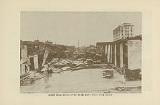
Coastal damage in Florida near the point of landfall was catastrophic. MiamiMiami, Florida
Miami is a city located on the Atlantic coast in southeastern Florida and the county seat of Miami-Dade County, the most populous county in Florida and the eighth-most populous county in the United States with a population of 2,500,625...
, well south of the point of landfall, escaped with very little damage; Hollywood
Hollywood, Florida
-Demographics:As of 2000, there were 59,673 households out of which 24.9% had children under the age of 18 living with them, 41.5% were married couples living together, 11.9% had a female householder with no husband present, and 42.2% were non-families. 34.4% of all households were made up of...
and Fort Lauderdale
Fort Lauderdale, Florida
Fort Lauderdale is a city in the U.S. state of Florida, on the Atlantic coast. It is the county seat of Broward County. As of the 2010 census, the city had a population of 165,521. It is a principal city of the South Florida metropolitan area, which was home to 5,564,635 people at the 2010...
suffered only slight damages. In Fort Lauderdale, numerous power lines and telephone wires were downed. Northward, from Pompano Beach
Pompano Beach, Florida
Pompano Beach ) is a city in Broward County, Florida, along the coast of the Atlantic Ocean just to the north of Fort Lauderdale. The nearby Hillsboro Inlet forms part of the Atlantic Intracoastal Waterway. As of the 2010 census, the city's population was 99,845...
to Jupiter
Jupiter, Florida
Jupiter is a town located in Palm Beach County, Florida. As of the 2000 census, the town had a total population of 39,328. The estimate population for 2009 is 50,606. As of 2006, the population had grown to 50,028, according to the University of Florida, Bureau of Economic and Business Research....
, buildings suffered serious damage from the heavy winds and 10 ft (3 m) storm surge, which was heaviest in the vicinity of Palm Beach
Palm Beach, Florida
The Town of Palm Beach is an incorporated town in Palm Beach County, Florida, United States. The Intracoastal Waterway separates it from the neighboring cities of West Palm Beach and Lake Worth...
; total coastal damages were estimated as "several million" dollars. In West Palm Beach, more than 1,711 homes were destroyed, while the Jupiter Inlet Light
Jupiter Inlet Light
The Jupiter Inlet Light is located in Jupiter, Florida, on the north side of the Jupiter Inlet. The site for the lighthouse was chosen in 1853. It is located between Cape Canaveral Light and Hillsboro Inlet Light. The lighthouse was designed by then Lieutenant George G. Meade of the Bureau of...
house's mortar was reportedly "squeezed ...like toothpaste" between the bricks during the storm, swaying the tower 17 inches (43.2 cm) off the base. Because of well-issued hurricane warnings, residents were prepared for the storm, and the number of lives lost in the coastal Palm Beach area was only 26.
Storm surge
A storm surge is an offshore rise of water associated with a low pressure weather system, typically tropical cyclones and strong extratropical cyclones. Storm surges are caused primarily by high winds pushing on the ocean's surface. The wind causes the water to pile up higher than the ordinary sea...
to overflow the small dike that had been built at the south end of the lake. The resulting flood covered an area of hundreds of square miles with water that in some places was over 20 ft (6 m) deep. Houses were floated off of their foundations and dashed to pieces against any obstacle they encountered. However, for the few families who resided on Torry Island, the breached dike saved their lives. The rising flood waters forced most families on to the roofs of their houses in an act of desperation. The dike's failure drained the lake and those on the island survived. Among the surviving on Torry Island were the families of Jesse Lee and Gus Cromartie. Meanwhile, most survivors and bodies were washed out into the Everglades
Everglades
The Everglades are subtropical wetlands in the southern portion of the U.S. state of Florida, comprising the southern half of a large watershed. The system begins near Orlando with the Kissimmee River, which discharges into the vast but shallow Lake Okeechobee...
where many of the bodies were never found. As the rear eyewall passed over the area, the flood reversed itself, breaking the dikes along the northern coast of the lake and causing a similar but smaller flood.
National Weather Service
The National Weather Service , once known as the Weather Bureau, is one of the six scientific agencies that make up the National Oceanic and Atmospheric Administration of the United States government...
for many years (and exactly equal to the official count for Hurricane Katrina
Hurricane Katrina
Hurricane Katrina of the 2005 Atlantic hurricane season was a powerful Atlantic hurricane. It is the costliest natural disaster, as well as one of the five deadliest hurricanes, in the history of the United States. Among recorded Atlantic hurricanes, it was the sixth strongest overall...
). Older sources usually list 3,411 as the hurricane's total count of fatalities, including the Caribbean. However, in 2003 the U.S. death count was revised as "at least" 2,500, making the Okeechobee hurricane the second-deadliest natural disaster in United States history behind the Galveston Hurricane of 1900
Galveston Hurricane of 1900
The Hurricane of 1900 made landfall on the city of Galveston in the U.S. state of Texas, on September 8, 1900.It had estimated winds of at landfall, making it a Category 4 storm on the Saffir-Simpson Hurricane Scale...
. A mass grave at the Port Mayaca Cemetery east of Port Mayaca contains the bodies of 1,600 victims of the hurricane.
Thousands of people were left homeless in Florida; property damage was estimated at $25 million ($). It is estimated if a similar storm were to strike as of the year 2003, it would cause $18.7 billion in damages. The cyclone remains one of three Atlantic hurricanes to strike the southern mainland of Florida with a central pressure below 940 mbar (27.76 inHg), the others being the 1926 Miami hurricane
1926 Miami Hurricane
The 1926 Miami hurricane was a Category 4 hurricane that devastated Miami in September 1926. The storm also caused significant damage in the Florida Panhandle, the U.S. state of Alabama, and the Bahamas...
and Hurricane Andrew
Hurricane Andrew
Hurricane Andrew was the third Category 5 hurricane to make landfall in the United States, after the Labor Day Hurricane of 1935 and Hurricane Camille in 1969. Andrew was the first named storm and only major hurricane of the otherwise inactive 1992 Atlantic hurricane season...
of 1992
1992 Atlantic hurricane season
The 1992 Atlantic hurricane season had one of the latest dates on record for the first named storm. The season officially began on June 1, 1992, and lasted until November 30, 1992. It was the least active hurricane season in nine years due to a strong El Niño...
.
Elsewhere
Limited damage reports are available for the United States outside of southern Florida. The storm caused flooding in North CarolinaNorth Carolina
North Carolina is a state located in the southeastern United States. The state borders South Carolina and Georgia to the south, Tennessee to the west and Virginia to the north. North Carolina contains 100 counties. Its capital is Raleigh, and its largest city is Charlotte...
and brought near-hurricane-force winds and a 7 foot (2.1 m) storm surge to the Norfolk
Norfolk, Virginia
Norfolk is an independent city in the Commonwealth of Virginia in the United States. With a population of 242,803 as of the 2010 Census, it is Virginia's second-largest city behind neighboring Virginia Beach....
area. Nonetheless, most sources agree that the hurricane caused only minimal damage in these areas.
Racial issues
In Florida, although the hurricane destroyed everything in its path with impartiality, the death toll was by far highest in the economically poor areas in the low-lying ground right around Lake Okeechobee. Around 75% of the fatalities were from migrant farm workers, most of whom were black. Black workers did most of the cleanup, and the few caskets available for burials were mostly used for the bodies of whites; other bodies were either burned or buried in mass graves. Burials were segregated, and the only mass gravesite to receive a memorial contained only white bodies. The inequity has caused ongoing racial friction that still exists. The effects of the hurricane on black migrant workers is dramatized in Zora Neale HurstonZora Neale Hurston
Zora Neale Hurston was an American folklorist, anthropologist, and author during the time of the Harlem Renaissance...
's novel Their Eyes Were Watching God
Their Eyes Were Watching God
Their Eyes Were Watching God is a 1937 novel and the best-known work by African American writer Zora Neale Hurston. Set in central and southern Florida in the early 20th century, the novel garnered attention and controversy at the time of its publication, and has come to be regarded as a seminal...
.
Improved building codes
In the aftermath of the hurricane in coastal Florida, it became apparent that well-constructed buildings with shutters had suffered practically no damage from winds that caused serious structural problems to lesser buildings. Buildings with well-constructed frames, and those made of steel, concrete, brick, or stone were largely immune to winds, and the use of shutters prevented damage to windows and the interior of the buildings. Coming on the heels of the 1926 Miami hurricane where a similar pattern had been noticed, one lasting result of the 1928 storm was improved building codes.Flood control
Herbert Hoover
Herbert Clark Hoover was the 31st President of the United States . Hoover was originally a professional mining engineer and author. As the United States Secretary of Commerce in the 1920s under Presidents Warren Harding and Calvin Coolidge, he promoted partnerships between government and business...
, the Corps drafted a new plan which provided for the construction of floodway channels, control gates, and major levees along Lake Okeechobee's shores. A long term system was designed for the purpose of flood control, water conservation, prevention of saltwater intrusion, and preservation of fish and wildlife populations. One of the solutions was the construction of the Herbert Hoover Dike
Herbert Hoover Dike
The Herbert Hoover Dike is a dike around the waters of Lake Okeechobee in Florida.Over the years, the quality of the flood control around the lake has grown. In the 1910s, a small earthen dike was constructed. This containment was breached by the storm surge from the Great Miami Hurricane in 1926...
. Today, concerns related to the dike's stability have grown in response to studies indicating long term problems with "piping" and erosion
Erosion
Erosion is when materials are removed from the surface and changed into something else. It only works by hydraulic actions and transport of solids in the natural environment, and leads to the deposition of these materials elsewhere...
. Leaks have been reported after several heavy rain events. Proposed solutions to the dike's problems have included the construction of a seepage
Soil mechanics
Soil mechanics is a branch of engineering mechanics that describes the behavior of soils. It differs from fluid mechanics and solid mechanics in the sense that soils consist of a heterogeneous mixture of fluids and particles but soil may also contain organic solids, liquids, and gasses and other...
berm
Berm
A berm is a level space, shelf, or raised barrier separating two areas. Berm originates in the Middle Dutch and German berme and came into usage in English via French.- History :...
on the landward side of the dike, with the first stage costing approximately $67 million (USD
United States dollar
The United States dollar , also referred to as the American dollar, is the official currency of the United States of America. It is divided into 100 smaller units called cents or pennies....
).
See also
- Hurricane of 1928 African American Mass Burial SiteHurricane of 1928 African American Mass Burial SiteThe Hurricane of 1928 African American Mass Burial Site is a historic site in West Palm Beach, Florida. It is located near the junction of 25th Street and Tamarind Avenue, between I-95 and US 1. On September 12, 2002, it was added to the U.S...
- Port Mayaca, Florida Location of mass burial site of 1,600 Victims
- List of Atlantic hurricanes
- List of Category 5 Atlantic hurricanes
- List of Florida hurricanes