
.gif)
Hurricane Isis (1998)
Encyclopedia
Hurricane Isis was the deadliest tropical cyclone
and only hurricane
to make landfall
during the 1998 Pacific hurricane season
. The ninth tropical storm and sixth hurricane of the season, Isis developed on September 1 from the interaction between a tropical wave
and a large surface circulation to the southwest of Mexico
. It moved northward, striking the extreme southeastern portion of the Baja California peninsula
before attaining hurricane status in the Gulf of California
. Isis made landfall at Topolobampo in the Mexican state of Sinaloa
on September 3, and quickly lost its low-level circulation. The remnants persisted for several days before dissipating in the U.S. state
of Idaho
.
In Mexico, Isis destroyed over 700 houses and killed 14 people; this is primarily due to its heavy rainfall which peaked at over 20 inches (500 mm) in southern Baja California Sur
. The rainfall caused widespread damage to roads and railways, stranding thousands of people. Moisture from the remnants of Isis extended into the southwestern United States
, resulting in light rainfall, dozens of traffic accidents, and power outages to thousands of residents in San Diego County, California
.
moved off the coast of Africa
on August 14, 1998. It traveled westward, and on August 19 spawned the tropical depression that eventually became Hurricane Bonnie
. The wave continued westward across the Atlantic Ocean
and Caribbean Sea
, and crossed Central America
into the eastern Pacific Ocean
on August 25. The wave decreased its forward speed while approaching a large low-level circulation over southern Mexico
. A broad area of disturbed weather formed in association with the wave and the low-level circulation, and after persisting for several days developed a smaller low-level circulation on August 29 about 575 miles (925 km) south-southeast of Cabo San Lucas
. On August 31, the two primary areas of convection were well-removed from the center. By early on September 1, despite a lack of convective organization, the low-cloud circulation was sufficiently well-defined that the National Hurricane Center
designated it as Tropical Depression Ten-E, or the tenth tropical depression of the season, about 350 miles (565 km) south of Cabo San Lucas. In real time, the National Hurricane Center first upgraded the system 21 hours later.
The depression initially tracked slowly north-northwestward and gradually strengthened. Late on September 1 it intensified into Tropical Storm Isis while located about 200 miles (320 km) south of Cabo San Lucas. Upon becoming a tropical storm, the deep convection was not organized, causing one forecaster to describe Isis as a large monsoon
-like system. A mid-level trough
extending southward from the Arizona
/California
border caused the storm to accelerate northward. The storm quickly strengthened; six hours after Isis became a tropical storm it reached winds of 70 mph (115 km/h). Very deep, symmetrical convection developed over the poorly defined center of circulation while banding features
began to form, although ill-defined outflow
and land interaction with the Baja California Peninsula
initially prevented further strengthening. At 1200 UTC
on September 2, Isis made landfall on extreme southeastern Baja California Sur
as a strong tropical storm, and subsequently turned to the north-northeast.
After entering the Gulf of California
, an eye
began to become apparent on visible satellite imagery, and it is estimated Isis attained hurricane status late on September 2. Continuing northward, it struck Topolobampo
in the state of Sinaloa
early on September 3 as a minimal hurricane. Isis weakened to a tropical storm a few hours after landfall, and subsequent to turning to the north-northwest the low-level circulation dissipated over Sierra Madre Occidental
. The remnants entered southern Arizona on September 4 and tracked around an upper-level low. After entering Nevada
on September 5, the remnants of Isis passed into Oregon
before dissipating in Idaho
on September 8.
from Dolores to Puerto Cortés
along the Baja California Peninsula
. This helped some of the residents get an early start.Early on September 2, the warning was extended from Santa Rosalía
to Punta Abreojos, while an additional tropical storm warning was issued from El Dorado
to Guaymas
. After Isis became a hurricane, officials issued a hurricane warning from Dolores to Punta San Gabriel on the Baja California Peninsula and from El Dorado to Bahía Kino
on the mainland.
In Baja California Sur
, 2,500 residents were evacuated to emergency shelters. Officials closed the port at Mazatlán
and recommended fisherman along the coast of the Gulf of California
to remain at port. Officials set up 49 shelters on the mainland to provide evacuees with food, clothing and medical attention. The Mexican Army
assisted residents in evacuation, and the Navy
provided medical aid and assistance to boat owners. More than 24,000 people were sheltered during the storm.
 Isis first affected Baja California Sur
on September 2 as a tropical storm. Shortly after making landfall, a weather reporting station at San José del Cabo
recorded sustained winds of 26 mph (42 km/h), and gusts reaching up to 46 mph (74 km/h). A station on the Islas Marías
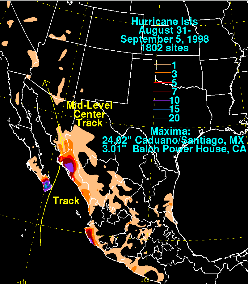
also reported sustained winds of 54 mph (87 km/h). The winds left widespread areas without power or telephone. The storm produced heavy rainfall in the southern portion of the peninsula, including a 24–hour total of 12.99 inches (330 mm) at Los Cabos
and a peak rainfall total of 24.02 inches (610 mm) at Santiago
. A married couple was killed after attempting to cross a flooded stream in Los Cabos. Initially, reports indicated a family was missing in La Paz
, though they were later proven false. Flooding from the storm closed all roads to the north of Los Cabos and caused damage to the roads in the area. Mudslides from the rain buried at least 120 cars in the area.
Rainfall reached over 10 inches (250 mm) in the coastal region of Jalisco
, and lighter amounts of precipitation extended further to the southeast and northeast. One person was reported missing in Jalisco. The heaviest 24–hour rainfall total in the state of Sinaloa
was 8.66 inches (220 mm), whereas in Sonora
a maximum of 4.72 inches (120 mm) of rain were recorded. Strong waves from the hurricane struck the Mexican mainland, with four people injured at Mazatlán
when their boat washed onto rocks and was destroyed. Rainfall from the storm flooded 15 communities in and around Mazatlán, and the Army assisted residents in emergency evacuations. At Los Mochis
, near the point where Isis made landfall, the hurricane resulted in the destruction of 300 homes, as well as in seven fatalities. Throughout the city, strong winds from the hurricane downed street posts, tree limbs, and power lines, with one person seriously injured from a downed power line. Additionally, the roof of a gas station collapsed from the winds. More than 1,200 bus passengers in Sinaloa were stranded due to road closures from the hurricane, including the closure of the coastal highway in the southern portion of Sinaloa as it had been washed out due to floodwaters. Rainfall from the storm caused severe river flooding in some locations, and authorities advised those living along the Fuerte River
to be prepared for a possible evacuation. The winds from Isis left about 120,000 people in the municipality of Ahome
without power.
Throughout Mexico, the passage of Hurricane Isis resulted in 14 deaths and the loss of 769 homes, with property damage estimates totaling over $5 million (1998 USD
, 50 million 1998 MXN, $6.3 million 2007 USD). According to a speech by President
Ernesto Zedillo
, Isis damaged the water systems in 173 localities
; it also damaged 154 primary schools and nine high schools, minor in most cases, causing most schools to be closed for around a week. A total of 730 miles (1175 km) of railroad track was damaged by mudslides or flooding, with one bridge entirely destroyed and another four damaged.
, resulting in some flash flood warnings and flooding on roadways. The heaviest precipitation fell across the Santa Catalina
and Rincon Mountains
near Tucson
, which saw precipitation amounts of up to three inches (75 mm). Otherwise, no flooding was reported in the Tucson area, and the Tucson International Airport
reported only 1.1 inches (28 mm) as a result of the storm.
The moisture extended into southern California
and produced moderate precipitation across the region. Bakersfield
reported a one-day rainfall record on September 4 with 0.23 inches (5.8 mm) of precipitation, breaking the previous record of 0.17 inches (4.3 mm) set in 1963. Rainfall amounts at Frazier Park
peaked at 1.53 inches (39 mm). Agricultural losses, primarily from vintners
and raisin growers, rose up to $5 million in damage (1998 USD, $6.33 million 2007 USD), either directly due to rain or indirectly due to the additional steps to treat the increase in fungus activity on produce. Slick roads from the rain resulted in nearly 80 traffic accidents in San Diego County
, ranging from fender benders to moderate injuries. Thunderstorms from the remnants of Isis damaged a San Diego Gas & Electric
substation at Kearny Mesa
, leaving 10,000 customers without power; the outage was short lived and completely restored within two hours. About 1,000 homes and businesses were temporarily without power in Escondido
, and another 2,700 customers lost electricity in Rancho Bernardo. Rainfall in and around San Diego
reached a maximum of 0.5 inches (13 mm) at La Mesa
. Heavy clouds from Isis produced scattered rainfall and temporary relief to severe heat conditions in the Los Angeles
area.
Moisture from the remnants of Isis spread across the southwestern United States, and rainfall reached over 0.75 inches (19 mm) in Nevada
and Utah
. Low-level moisture dissipated as it continued inland, due to dry air, although upper-level moisture produced light rain across the Northwestern United States
; Pocatello, Idaho
recorded 0.59 inches (15 mm), while Missoula, Montana
recorded 0.39 inches (10 mm).
/6 million L
) of water and provided repair equipment to the 173 localities whose water systems were damaged. More than 650 health workers worked to combat the spread of diseases, including monitoring sanitary conditions of water and foods, and sprayed nearly 9900 acres (40.1 km²) of land to prevent the breeding of mosquito
es. The force also disinfected more than 6,600 latrines and removed more than 850 short tons (771.1 t) of sewage to prevent the spread of epidemic. No medical-related deaths occurred as a result of this attention.
Twenty-four hours after the passage of the hurricane, workers had restored power to 70% of the affected residents in Sinaloa
, and by six days after the storm, electrical service was completely restored. The damage to the federal highway between Culiacán
and Los Mochis
along the coastal region of Sinaloa was restored about 48 hours after the passage of the hurricane. The rehabilitation of the agricultural infrastructure began immediately, and most of the drainage networks were repaired by about two weeks after the hurricane. About half of the damaged railways were repaired by about a month after the storm. The total cost for reconstruction and aid amounted to about $18.5 million (1998 USD, 175 million 1998 MXN, $23.3 million 2007 USD), about 94% from federal funds and the rest from state funding. A portion of the funding was allocated to assist the reconstruction of destroyed houses.
Because the damage Isis caused was neither extreme nor exceptional, the name Isis was not retired by the World Meteorological Organization
. It was re-used for a storm in the 2004 Pacific hurricane season, and continues to be on the list of tropical cyclone names for the 2010 season.
Tropical cyclone
A tropical cyclone is a storm system characterized by a large low-pressure center and numerous thunderstorms that produce strong winds and heavy rain. Tropical cyclones strengthen when water evaporated from the ocean is released as the saturated air rises, resulting in condensation of water vapor...
and only hurricane
Pacific hurricane
A Pacific hurricane or tropical storm is a tropical cyclone that develops in the northeastern part of the Pacific Ocean. For organizational purposes, the northern Pacific Ocean is divided into three regions: the eastern, , central , and western...
to make landfall
Landfall (meteorology)
Landfall is the event of a tropical cyclone or a waterspout coming onto land after being over water. When a waterspout makes landfall it is reclassified as a tornado, which can then cause damage inland...
during the 1998 Pacific hurricane season
1998 Pacific hurricane season
The 1998 Pacific hurricane season was a moderately active Pacific hurricane season with seven tropical cyclones directly affecting land. The season officially started on May 15 in the eastern Pacific, and on June 1 in the central Pacific, and ended on November 30; these dates conventionally delimit...
. The ninth tropical storm and sixth hurricane of the season, Isis developed on September 1 from the interaction between a tropical wave
Tropical wave
Tropical waves, easterly waves, or tropical easterly waves, also known as African easterly waves in the Atlantic region, are a type of atmospheric trough, an elongated area of relatively low air pressure, oriented north to south, which move from east to west across the tropics causing areas of...
and a large surface circulation to the southwest of Mexico
Mexico
The United Mexican States , commonly known as Mexico , is a federal constitutional republic in North America. It is bordered on the north by the United States; on the south and west by the Pacific Ocean; on the southeast by Guatemala, Belize, and the Caribbean Sea; and on the east by the Gulf of...
. It moved northward, striking the extreme southeastern portion of the Baja California peninsula
Baja California Peninsula
The Baja California peninsula , is a peninsula in northwestern Mexico. Its land mass separates the Pacific Ocean from the Gulf of California. The Peninsula extends from Mexicali, Baja California in the north to Cabo San Lucas, Baja California Sur in the south.The total area of the Baja California...
before attaining hurricane status in the Gulf of California
Gulf of California
The Gulf of California is a body of water that separates the Baja California Peninsula from the Mexican mainland...
. Isis made landfall at Topolobampo in the Mexican state of Sinaloa
Sinaloa
Sinaloa officially Estado Libre y Soberano de Sinaloa is one of the 31 states which, with the Federal District, comprise the 32 Federal Entities of Mexico. It is divided in 18 municipalities and its capital city is Culiacán Rosales....
on September 3, and quickly lost its low-level circulation. The remnants persisted for several days before dissipating in the U.S. state
U.S. state
A U.S. state is any one of the 50 federated states of the United States of America that share sovereignty with the federal government. Because of this shared sovereignty, an American is a citizen both of the federal entity and of his or her state of domicile. Four states use the official title of...
of Idaho
Idaho
Idaho is a state in the Rocky Mountain area of the United States. The state's largest city and capital is Boise. Residents are called "Idahoans". Idaho was admitted to the Union on July 3, 1890, as the 43rd state....
.
In Mexico, Isis destroyed over 700 houses and killed 14 people; this is primarily due to its heavy rainfall which peaked at over 20 inches (500 mm) in southern Baja California Sur
Baja California Sur
Baja California Sur , is one of the 31 states which, with the Federal District, comprise the 32 Federal Entities of Mexico. Before becoming a state on October 8, 1974, the area was known as the South Territory of Baja California. It has an area of , or 3.57% of the land mass of Mexico and comprises...
. The rainfall caused widespread damage to roads and railways, stranding thousands of people. Moisture from the remnants of Isis extended into the southwestern United States
Southwestern United States
The Southwestern United States is a region defined in different ways by different sources. Broad definitions include nearly a quarter of the United States, including Arizona, California, Colorado, Nevada, New Mexico, Oklahoma, Texas and Utah...
, resulting in light rainfall, dozens of traffic accidents, and power outages to thousands of residents in San Diego County, California
San Diego County, California
San Diego County is a large county located in the southwestern corner of the US state of California. Hence, San Diego County is also located in the southwestern corner of the 48 contiguous United States. Its county seat and largest city is San Diego. Its population was about 2,813,835 in the 2000...
.
Meteorological history
A tropical waveTropical wave
Tropical waves, easterly waves, or tropical easterly waves, also known as African easterly waves in the Atlantic region, are a type of atmospheric trough, an elongated area of relatively low air pressure, oriented north to south, which move from east to west across the tropics causing areas of...
moved off the coast of Africa
Africa
Africa is the world's second largest and second most populous continent, after Asia. At about 30.2 million km² including adjacent islands, it covers 6% of the Earth's total surface area and 20.4% of the total land area...
on August 14, 1998. It traveled westward, and on August 19 spawned the tropical depression that eventually became Hurricane Bonnie
Hurricane Bonnie (1998)
Hurricane Bonnie was a major hurricane that made landfall in North Carolina, United States, inflicting severe crop damage. The second named storm, first hurricane, and first major hurricane of the 1998 Atlantic hurricane season, Bonnie developed from a tropical wave that emerged off the coast of...
. The wave continued westward across the Atlantic Ocean
Atlantic Ocean
The Atlantic Ocean is the second-largest of the world's oceanic divisions. With a total area of about , it covers approximately 20% of the Earth's surface and about 26% of its water surface area...
and Caribbean Sea
Caribbean Sea
The Caribbean Sea is a sea of the Atlantic Ocean located in the tropics of the Western hemisphere. It is bounded by Mexico and Central America to the west and southwest, to the north by the Greater Antilles, and to the east by the Lesser Antilles....
, and crossed Central America
Central America
Central America is the central geographic region of the Americas. It is the southernmost, isthmian portion of the North American continent, which connects with South America on the southeast. When considered part of the unified continental model, it is considered a subcontinent...
into the eastern Pacific Ocean
Pacific Ocean
The Pacific Ocean is the largest of the Earth's oceanic divisions. It extends from the Arctic in the north to the Southern Ocean in the south, bounded by Asia and Australia in the west, and the Americas in the east.At 165.2 million square kilometres in area, this largest division of the World...
on August 25. The wave decreased its forward speed while approaching a large low-level circulation over southern Mexico
Mexico
The United Mexican States , commonly known as Mexico , is a federal constitutional republic in North America. It is bordered on the north by the United States; on the south and west by the Pacific Ocean; on the southeast by Guatemala, Belize, and the Caribbean Sea; and on the east by the Gulf of...
. A broad area of disturbed weather formed in association with the wave and the low-level circulation, and after persisting for several days developed a smaller low-level circulation on August 29 about 575 miles (925 km) south-southeast of Cabo San Lucas
Cabo San Lucas
Cabo San Lucas , commonly called Cabo, is a city at the southern tip of the Baja California peninsula, in the municipality of Los Cabos in the Mexican state of Baja California Sur. As of the 2010 census, the population was 68,463 people...
. On August 31, the two primary areas of convection were well-removed from the center. By early on September 1, despite a lack of convective organization, the low-cloud circulation was sufficiently well-defined that the National Hurricane Center
National Hurricane Center
The National Hurricane Center , located at Florida International University in Miami, Florida, is the division of the National Weather Service responsible for tracking and predicting weather systems within the tropics between the Prime Meridian and the 140th meridian west poleward to the 30th...
designated it as Tropical Depression Ten-E, or the tenth tropical depression of the season, about 350 miles (565 km) south of Cabo San Lucas. In real time, the National Hurricane Center first upgraded the system 21 hours later.
The depression initially tracked slowly north-northwestward and gradually strengthened. Late on September 1 it intensified into Tropical Storm Isis while located about 200 miles (320 km) south of Cabo San Lucas. Upon becoming a tropical storm, the deep convection was not organized, causing one forecaster to describe Isis as a large monsoon
Monsoon
Monsoon is traditionally defined as a seasonal reversing wind accompanied by corresponding changes in precipitation, but is now used to describe seasonal changes in atmospheric circulation and precipitation associated with the asymmetric heating of land and sea...
-like system. A mid-level trough
Trough (meteorology)
A trough is an elongated region of relatively low atmospheric pressure, often associated with fronts.Unlike fronts, there is not a universal symbol for a trough on a weather chart. The weather charts in some countries or regions mark troughs by a line. In the United States, a trough may be marked...
extending southward from the Arizona
Arizona
Arizona ; is a state located in the southwestern region of the United States. It is also part of the western United States and the mountain west. The capital and largest city is Phoenix...
/California
California
California is a state located on the West Coast of the United States. It is by far the most populous U.S. state, and the third-largest by land area...
border caused the storm to accelerate northward. The storm quickly strengthened; six hours after Isis became a tropical storm it reached winds of 70 mph (115 km/h). Very deep, symmetrical convection developed over the poorly defined center of circulation while banding features
Rainband
A rainband is a cloud and precipitation structure associated with an area of rainfall which is significantly elongated. Rainbands can be stratiform or convective, and are generated by differences in temperature. When noted on weather radar imagery, this precipitation elongation is referred to as...
began to form, although ill-defined outflow
Outflow (meteorology)
Outflow, in meteorology, is air that flows outwards from a storm system. It is associated with ridging, or anticyclonic flow. In the low levels of the troposphere, outflow radiates from thunderstorms in the form of a wedge of rain-cooled air, which is visible as a thin rope-like cloud on weather...
and land interaction with the Baja California Peninsula
Baja California Peninsula
The Baja California peninsula , is a peninsula in northwestern Mexico. Its land mass separates the Pacific Ocean from the Gulf of California. The Peninsula extends from Mexicali, Baja California in the north to Cabo San Lucas, Baja California Sur in the south.The total area of the Baja California...
initially prevented further strengthening. At 1200 UTC
Coordinated Universal Time
Coordinated Universal Time is the primary time standard by which the world regulates clocks and time. It is one of several closely related successors to Greenwich Mean Time. Computer servers, online services and other entities that rely on having a universally accepted time use UTC for that purpose...
on September 2, Isis made landfall on extreme southeastern Baja California Sur
Baja California Sur
Baja California Sur , is one of the 31 states which, with the Federal District, comprise the 32 Federal Entities of Mexico. Before becoming a state on October 8, 1974, the area was known as the South Territory of Baja California. It has an area of , or 3.57% of the land mass of Mexico and comprises...
as a strong tropical storm, and subsequently turned to the north-northeast.
After entering the Gulf of California
Gulf of California
The Gulf of California is a body of water that separates the Baja California Peninsula from the Mexican mainland...
, an eye
Eye (cyclone)
The eye is a region of mostly calm weather found at the center of strong tropical cyclones. The eye of a storm is a roughly circular area and typically 30–65 km in diameter. It is surrounded by the eyewall, a ring of towering thunderstorms where the second most severe weather of a cyclone...
began to become apparent on visible satellite imagery, and it is estimated Isis attained hurricane status late on September 2. Continuing northward, it struck Topolobampo
Topolobampo
Topolobampo is a port on the Gulf of California in northwestern Sinaloa, Mexico. It is the fourth-largest town in the municipality of Ahome , reporting a 2005 census population of 6,032 inhabitants....
in the state of Sinaloa
Sinaloa
Sinaloa officially Estado Libre y Soberano de Sinaloa is one of the 31 states which, with the Federal District, comprise the 32 Federal Entities of Mexico. It is divided in 18 municipalities and its capital city is Culiacán Rosales....
early on September 3 as a minimal hurricane. Isis weakened to a tropical storm a few hours after landfall, and subsequent to turning to the north-northwest the low-level circulation dissipated over Sierra Madre Occidental
Sierra Madre Occidental
The Sierra Madre Occidental is a mountain range in western Mexico.-Setting:The range runs north to south, from just south of the Sonora–Arizona border southeast through eastern Sonora, western Chihuahua, Sinaloa, Durango, Zacatecas, Nayarit, Jalisco, Aguascalientes to Guanajuato, where it joins...
. The remnants entered southern Arizona on September 4 and tracked around an upper-level low. After entering Nevada
Nevada
Nevada is a state in the western, mountain west, and southwestern regions of the United States. With an area of and a population of about 2.7 million, it is the 7th-largest and 35th-most populous state. Over two-thirds of Nevada's people live in the Las Vegas metropolitan area, which contains its...
on September 5, the remnants of Isis passed into Oregon
Oregon
Oregon is a state in the Pacific Northwest region of the United States. It is located on the Pacific coast, with Washington to the north, California to the south, Nevada on the southeast and Idaho to the east. The Columbia and Snake rivers delineate much of Oregon's northern and eastern...
before dissipating in Idaho
Idaho
Idaho is a state in the Rocky Mountain area of the United States. The state's largest city and capital is Boise. Residents are called "Idahoans". Idaho was admitted to the Union on July 3, 1890, as the 43rd state....
on September 8.
Preparations
Coinciding with the National Hurricane Center's first advisory on Isis, the government of Mexico issued a tropical storm warningTropical cyclone warnings and watches
Warnings and watches are two levels of alert issued by national weather forecasting bodies to coastal areas threatened by the imminent approach of a tropical cyclone of tropical storm or hurricane intensity. They are notices to the local population and civil authorities to make appropriate...
from Dolores to Puerto Cortés
Puerto Cortés, Baja California Sur
Puerto Cortés is a small settlement on Isla Santa Margarita, off the Pacific coast of the Mexican state of Baja California Sur. It is part of Comondú Municipality. There is a naval base there. It is sometimes used as a breakpoint in metereological reports. The 2010 census reported no official...
along the Baja California Peninsula
Baja California Peninsula
The Baja California peninsula , is a peninsula in northwestern Mexico. Its land mass separates the Pacific Ocean from the Gulf of California. The Peninsula extends from Mexicali, Baja California in the north to Cabo San Lucas, Baja California Sur in the south.The total area of the Baja California...
. This helped some of the residents get an early start.Early on September 2, the warning was extended from Santa Rosalía
Santa Rosalía, Baja California Sur
Santa Rosalía is a city located on the Baja California peninsula, in the northern part of the Mexican state of Baja California Sur. It was named after Saint Rosalia, although the reason for the name is not quite clear since the Misión de Santa Rosalía is not located by the town, but rather in...
to Punta Abreojos, while an additional tropical storm warning was issued from El Dorado
El Dorado, Sinaloa
El Dorado is a community approximately one hour away from Culiacán in the Mexican state of Sinaloa. It is about a 20-minute drive from "Las Arenitas", a small fishing town.el dorado es caracterisado por sus umildes havitantes que en conjunto fe travajo hasen que el alimento y demas cosas...
to Guaymas
Guaymas
Guaymas is a city and municipality located in the southwest part of the state of Sonora in northwestern Mexico. The city is located 117 km south of the state capital of Hermosillo, and 242 miles from the U.S. border, and is the principal port for the state. The municipality is located in the...
. After Isis became a hurricane, officials issued a hurricane warning from Dolores to Punta San Gabriel on the Baja California Peninsula and from El Dorado to Bahía Kino
Bahía Kino
Bahía Kino is a town in the Mexican state of Sonora, on the Sea of Cortez Gulf of California; it was named after Eusebio Kino. The name also applies to the adjacent bay between Tiburón Island and Punta San Nicolás, Sonora...
on the mainland.
In Baja California Sur
Baja California Sur
Baja California Sur , is one of the 31 states which, with the Federal District, comprise the 32 Federal Entities of Mexico. Before becoming a state on October 8, 1974, the area was known as the South Territory of Baja California. It has an area of , or 3.57% of the land mass of Mexico and comprises...
, 2,500 residents were evacuated to emergency shelters. Officials closed the port at Mazatlán
Mazatlán
Mazatlán is a city in the Mexican state of Sinaloa; the surrounding municipio for which the city serves as the municipal seat is Mazatlán Municipality. It is located at on the Pacific coast, across from the southernmost tip of the Baja California peninsula.Mazatlán is a Nahuatl word meaning...
and recommended fisherman along the coast of the Gulf of California
Gulf of California
The Gulf of California is a body of water that separates the Baja California Peninsula from the Mexican mainland...
to remain at port. Officials set up 49 shelters on the mainland to provide evacuees with food, clothing and medical attention. The Mexican Army
Mexican Army
The Mexican Army is the combined land and air branch and largest of the Mexican Military services; it also is known as the National Defense Army. It is famous for having been the first army to adopt and use an automatic rifle, , in 1899, and the first to issue automatic weapons as standard issue...
assisted residents in evacuation, and the Navy
Mexican Navy
The Mexican Navy is the naval branch of the Mexican military responsible for conducting naval operations. Its stated mission is "to use the naval force of the federation for the exterior defense, and to help with internal order". The Navy consists of about 56,000 men and women plus reserves, over...
provided medical aid and assistance to boat owners. More than 24,000 people were sheltered during the storm.
Mexico
Baja California Sur
Baja California Sur , is one of the 31 states which, with the Federal District, comprise the 32 Federal Entities of Mexico. Before becoming a state on October 8, 1974, the area was known as the South Territory of Baja California. It has an area of , or 3.57% of the land mass of Mexico and comprises...
on September 2 as a tropical storm. Shortly after making landfall, a weather reporting station at San José del Cabo
San José del Cabo
The city of San José del Cabo is located in Baja California Sur Mexico and is the seat of the municipality of Los Cabos at the south end of the Baja California peninsula. In the 2010 census it had a population of 69,788. Together with neighboring Cabo San Lucas it forms a major tourist destination...
recorded sustained winds of 26 mph (42 km/h), and gusts reaching up to 46 mph (74 km/h). A station on the Islas Marías
Islas Marías
The Islas Marías are an archipelago of four islands that belong to Mexico. They are located in the Pacific Ocean, some off the coast of the state of Nayarit. They are part of the municipality of San Blas, Nayarit...
also reported sustained winds of 54 mph (87 km/h). The winds left widespread areas without power or telephone. The storm produced heavy rainfall in the southern portion of the peninsula, including a 24–hour total of 12.99 inches (330 mm) at Los Cabos
Los Cabos
Los Cabos is a municipality located at the southern tip of Mexico's Baja California Peninsula, in the state of Baja California Sur. It encompasses the towns of Cabo San Lucas and San José del Cabo , as well as the Resort Corridor that lies between the two...
and a peak rainfall total of 24.02 inches (610 mm) at Santiago
Santiago, Baja California Sur
Santiago is a small town in Los Cabos Municipality in Baja California Sur, Mexico, located on Mexico's Highway 1, about an hour's drive north of San José del Cabo....
. A married couple was killed after attempting to cross a flooded stream in Los Cabos. Initially, reports indicated a family was missing in La Paz
La Paz, Baja California Sur
La Paz is the capital city of the Mexican state of Baja California Sur and an important regional commercial center. The city had a 2010 census population of 215,178 persons, but its metropolitan population is somewhat larger because of surrounding towns like el Centenario, el Zacatal and San Pedro...
, though they were later proven false. Flooding from the storm closed all roads to the north of Los Cabos and caused damage to the roads in the area. Mudslides from the rain buried at least 120 cars in the area.
Rainfall reached over 10 inches (250 mm) in the coastal region of Jalisco
Jalisco
Jalisco officially Estado Libre y Soberano de Jalisco is one of the 31 states which, with the Federal District, comprise the 32 Federal Entities of Mexico. It is located in Western Mexico and divided in 125 municipalities and its capital city is Guadalajara.It is one of the more important states...
, and lighter amounts of precipitation extended further to the southeast and northeast. One person was reported missing in Jalisco. The heaviest 24–hour rainfall total in the state of Sinaloa
Sinaloa
Sinaloa officially Estado Libre y Soberano de Sinaloa is one of the 31 states which, with the Federal District, comprise the 32 Federal Entities of Mexico. It is divided in 18 municipalities and its capital city is Culiacán Rosales....
was 8.66 inches (220 mm), whereas in Sonora
Sonora
Sonora officially Estado Libre y Soberano de Sonora is one of the 31 states which, with the Federal District, comprise the 32 Federal Entities of Mexico. It is divided into 72 municipalities; the capital city is Hermosillo....
a maximum of 4.72 inches (120 mm) of rain were recorded. Strong waves from the hurricane struck the Mexican mainland, with four people injured at Mazatlán
Mazatlán
Mazatlán is a city in the Mexican state of Sinaloa; the surrounding municipio for which the city serves as the municipal seat is Mazatlán Municipality. It is located at on the Pacific coast, across from the southernmost tip of the Baja California peninsula.Mazatlán is a Nahuatl word meaning...
when their boat washed onto rocks and was destroyed. Rainfall from the storm flooded 15 communities in and around Mazatlán, and the Army assisted residents in emergency evacuations. At Los Mochis
Los Mochis
Los Mochis is a coastal city in northern Sinaloa, Mexico. It serves as the municipal seat of the municipality of Ahome. As of the 2010 census, the population was 256,613, which was 61 percent of the municipality's population....
, near the point where Isis made landfall, the hurricane resulted in the destruction of 300 homes, as well as in seven fatalities. Throughout the city, strong winds from the hurricane downed street posts, tree limbs, and power lines, with one person seriously injured from a downed power line. Additionally, the roof of a gas station collapsed from the winds. More than 1,200 bus passengers in Sinaloa were stranded due to road closures from the hurricane, including the closure of the coastal highway in the southern portion of Sinaloa as it had been washed out due to floodwaters. Rainfall from the storm caused severe river flooding in some locations, and authorities advised those living along the Fuerte River
Fuerte River
The Fuerte River is a river in the northwestern Mexican state of Sinaloa. It begins at the junction of the Verde and Urique rivers, on the Sierra Madre Occidental mountain range. It flows generally southwest for a distance of 290 km, emptying into the Gulf of California at Lechuguilla Island,...
to be prepared for a possible evacuation. The winds from Isis left about 120,000 people in the municipality of Ahome
Ahome
Ahome is a municipality on the coast of the Sea of Cortez in the northwestern part of the Mexican state of Sinaloa; it is adjacent to Higuera de Zaragoza, Sinaloa, and the southern border of Sonora state. It reported 388,344 inhabitants in the 2005 census. Ahome is also the name of the...
without power.
Throughout Mexico, the passage of Hurricane Isis resulted in 14 deaths and the loss of 769 homes, with property damage estimates totaling over $5 million (1998 USD
United States dollar
The United States dollar , also referred to as the American dollar, is the official currency of the United States of America. It is divided into 100 smaller units called cents or pennies....
, 50 million 1998 MXN, $6.3 million 2007 USD). According to a speech by President
President of Mexico
The President of the United Mexican States is the head of state and government of Mexico. Under the Constitution, the president is also the Supreme Commander of the Mexican armed forces...
Ernesto Zedillo
Ernesto Zedillo
Ernesto Zedillo Ponce de León is a Mexican economist and politician. He served as President of Mexico from December 1, 1994 to November 30, 2000, as the last of the uninterrupted seventy year line of Mexican presidents from the Institutional Revolutionary Party...
, Isis damaged the water systems in 173 localities
Municipalities of Mexico
Municipalities are the second-level administrative division in Mexico . There are 2,438 municipalities in Mexico, making the average municipality population 45,616...
; it also damaged 154 primary schools and nine high schools, minor in most cases, causing most schools to be closed for around a week. A total of 730 miles (1175 km) of railroad track was damaged by mudslides or flooding, with one bridge entirely destroyed and another four damaged.
United States
Thunderstorms from the remnants of Isis dropped more than two inches (50 mm) of rainfall across southern ArizonaArizona
Arizona ; is a state located in the southwestern region of the United States. It is also part of the western United States and the mountain west. The capital and largest city is Phoenix...
, resulting in some flash flood warnings and flooding on roadways. The heaviest precipitation fell across the Santa Catalina
Santa Catalina Mountains
The Santa Catalina Mountains, commonly referred to as the Catalina Mountains, are located north, and northeast of Tucson, Arizona, United States, on Tucson's north perimeter. The mountain range is the most prominent in the Tucson area, with the highest average elevation...
and Rincon Mountains
Rincon Mountains
The Rincon Mountains are a significant mountain range east of Tucson, Pima County, Arizona, in the United States. The Rincon Mountains are one of five mountain ranges surrounding the Tucson valley...
near Tucson
Tucson, Arizona
Tucson is a city in and the county seat of Pima County, Arizona, United States. The city is located 118 miles southeast of Phoenix and 60 miles north of the U.S.-Mexico border. The 2010 United States Census puts the city's population at 520,116 with a metropolitan area population at 1,020,200...
, which saw precipitation amounts of up to three inches (75 mm). Otherwise, no flooding was reported in the Tucson area, and the Tucson International Airport
Tucson International Airport
Tucson International Airport is a joint civil-military public airport located six miles south of the central business district of Tucson, in Pima County, Arizona, United States, and is the second largest and busiest airport in Arizona, after Sky Harbor International Airport in Phoenix.- Overview...
reported only 1.1 inches (28 mm) as a result of the storm.
The moisture extended into southern California
California
California is a state located on the West Coast of the United States. It is by far the most populous U.S. state, and the third-largest by land area...
and produced moderate precipitation across the region. Bakersfield
Bakersfield, California
Bakersfield is a city near the southern end of the San Joaquin Valley in Kern County, California. It is roughly equidistant between Fresno and Los Angeles, to the north and south respectively....
reported a one-day rainfall record on September 4 with 0.23 inches (5.8 mm) of precipitation, breaking the previous record of 0.17 inches (4.3 mm) set in 1963. Rainfall amounts at Frazier Park
Frazier Park, California
Frazier Park is an unincorporated community and census-designated place in Kern County, California. Frazier Park is west of Lebec, at an elevation of 4,639 feet . It is one of the Mountain Communities of the Tejon Pass...
peaked at 1.53 inches (39 mm). Agricultural losses, primarily from vintners
Winemaking
Winemaking, or vinification, is the production of wine, starting with selection of the grapes or other produce and ending with bottling the finished wine. Although most wine is made from grapes, it may also be made from other fruit or non-toxic plant material...
and raisin growers, rose up to $5 million in damage (1998 USD, $6.33 million 2007 USD), either directly due to rain or indirectly due to the additional steps to treat the increase in fungus activity on produce. Slick roads from the rain resulted in nearly 80 traffic accidents in San Diego County
San Diego County, California
San Diego County is a large county located in the southwestern corner of the US state of California. Hence, San Diego County is also located in the southwestern corner of the 48 contiguous United States. Its county seat and largest city is San Diego. Its population was about 2,813,835 in the 2000...
, ranging from fender benders to moderate injuries. Thunderstorms from the remnants of Isis damaged a San Diego Gas & Electric
San Diego Gas & Electric
San Diego Gas & Electric is the utility that provides natural gas and electricity to San Diego County and southern Orange County in southwestern California, United States...
substation at Kearny Mesa
Kearny Mesa
-External links:***...
, leaving 10,000 customers without power; the outage was short lived and completely restored within two hours. About 1,000 homes and businesses were temporarily without power in Escondido
Escondido, California
Escondido is a city occupying a shallow valley ringed by rocky hills, just north of the city of San Diego, California. Founded in 1888, it is one of the oldest cities in San Diego County. The city had a population of 143,911 at the 2010 census. Its municipal government set itself an operating...
, and another 2,700 customers lost electricity in Rancho Bernardo. Rainfall in and around San Diego
San Diego, California
San Diego is the eighth-largest city in the United States and second-largest city in California. The city is located on the coast of the Pacific Ocean in Southern California, immediately adjacent to the Mexican border. The birthplace of California, San Diego is known for its mild year-round...
reached a maximum of 0.5 inches (13 mm) at La Mesa
La Mesa, California
La Mesa is a city in San Diego County, California. The population was 57,065 at the 2010 census, up from 54,749 at the 2000 census. It was founded in 1869 and officially incorporated as a city on February 16, 1912. Its official flower is the bougainvillea....
. Heavy clouds from Isis produced scattered rainfall and temporary relief to severe heat conditions in the Los Angeles
Los Angeles, California
Los Angeles , with a population at the 2010 United States Census of 3,792,621, is the most populous city in California, USA and the second most populous in the United States, after New York City. It has an area of , and is located in Southern California...
area.
Moisture from the remnants of Isis spread across the southwestern United States, and rainfall reached over 0.75 inches (19 mm) in Nevada
Nevada
Nevada is a state in the western, mountain west, and southwestern regions of the United States. With an area of and a population of about 2.7 million, it is the 7th-largest and 35th-most populous state. Over two-thirds of Nevada's people live in the Las Vegas metropolitan area, which contains its...
and Utah
Utah
Utah is a state in the Western United States. It was the 45th state to join the Union, on January 4, 1896. Approximately 80% of Utah's 2,763,885 people live along the Wasatch Front, centering on Salt Lake City. This leaves vast expanses of the state nearly uninhabited, making the population the...
. Low-level moisture dissipated as it continued inland, due to dry air, although upper-level moisture produced light rain across the Northwestern United States
Northwestern United States
The Northwestern United States comprise the northwestern states up to the western Great Plains regions of the United States, and consistently include the states of Oregon, Washington, Idaho, Montana, Wyoming, to which part of southeast Alaska is also sometimes included...
; Pocatello, Idaho
Pocatello, Idaho
Pocatello is the county seat and largest city of Bannock County, with a small portion on the Fort Hall Indian Reservation in neighboring Power County, in the southeastern part of the U.S. state of Idaho. It is the principal city of the Pocatello metropolitan area, which encompasses all of Bannock...
recorded 0.59 inches (15 mm), while Missoula, Montana
Missoula, Montana
Missoula is a city located in western Montana and is the county seat of Missoula County. The 2010 Census put the population of Missoula at 66,788 and the population of Missoula County at 109,299. Missoula is the principal city of the Missoula Metropolitan Area...
recorded 0.39 inches (10 mm).
Aftermath
Aid programs began immediately after Isis moved ashore and dissipated to provided support to the affected population. The Comisión Nacional del Agua distributed 1.6 million U.S. gallons (1.3 million imp galImperial unit
The system of imperial units or the imperial system is the system of units first defined in the British Weights and Measures Act of 1824, which was later refined and reduced. The system came into official use across the British Empire...
/6 million L
Litér
- External links :*...
) of water and provided repair equipment to the 173 localities whose water systems were damaged. More than 650 health workers worked to combat the spread of diseases, including monitoring sanitary conditions of water and foods, and sprayed nearly 9900 acres (40.1 km²) of land to prevent the breeding of mosquito
Mosquito
Mosquitoes are members of a family of nematocerid flies: the Culicidae . The word Mosquito is from the Spanish and Portuguese for little fly...
es. The force also disinfected more than 6,600 latrines and removed more than 850 short tons (771.1 t) of sewage to prevent the spread of epidemic. No medical-related deaths occurred as a result of this attention.
Twenty-four hours after the passage of the hurricane, workers had restored power to 70% of the affected residents in Sinaloa
Sinaloa
Sinaloa officially Estado Libre y Soberano de Sinaloa is one of the 31 states which, with the Federal District, comprise the 32 Federal Entities of Mexico. It is divided in 18 municipalities and its capital city is Culiacán Rosales....
, and by six days after the storm, electrical service was completely restored. The damage to the federal highway between Culiacán
Culiacán
Culiacán is a city in northwestern Mexico, the largest city in the state of Sinaloa as well as its capital and capital of the municipality of Culiacán. With 675,773 inhabitants in the city , and 858,638 in the municipality, it is the largest city in the state of Sinaloa...
and Los Mochis
Los Mochis
Los Mochis is a coastal city in northern Sinaloa, Mexico. It serves as the municipal seat of the municipality of Ahome. As of the 2010 census, the population was 256,613, which was 61 percent of the municipality's population....
along the coastal region of Sinaloa was restored about 48 hours after the passage of the hurricane. The rehabilitation of the agricultural infrastructure began immediately, and most of the drainage networks were repaired by about two weeks after the hurricane. About half of the damaged railways were repaired by about a month after the storm. The total cost for reconstruction and aid amounted to about $18.5 million (1998 USD, 175 million 1998 MXN, $23.3 million 2007 USD), about 94% from federal funds and the rest from state funding. A portion of the funding was allocated to assist the reconstruction of destroyed houses.
Because the damage Isis caused was neither extreme nor exceptional, the name Isis was not retired by the World Meteorological Organization
World Meteorological Organization
The World Meteorological Organization is an intergovernmental organization with a membership of 189 Member States and Territories. It originated from the International Meteorological Organization , which was founded in 1873...
. It was re-used for a storm in the 2004 Pacific hurricane season, and continues to be on the list of tropical cyclone names for the 2010 season.
See also
- List of Baja California Peninsula hurricanes
- Other tropical cyclones named Isis
- Tropical cyclone rainfall climatologyTropical cyclone rainfall climatologyA tropical cyclone rainfall climatology is developed to determine rainfall characteristics of past tropical cyclones. A tropical cyclone rainfall climatology can be used to help forecast current or upcoming tropical cyclone impacts. The degree of a tropical cyclone rainfall impact depends upon...
External links
- The NHC's archive on Hurricane Isis.