
Hurricane Floyd
Overview
1999 Atlantic hurricane season
The 1999 Atlantic hurricane season officially began on June 1, 1999, and lasted until November 30, 1999. These dates conventionally delimit the period of each year when most tropical cyclones form in the Atlantic basin....
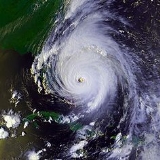
. Floyd triggered the third largest evacuation in US history (behind Hurricane Gustav
Hurricane Gustav
The name Gustav has been used for five tropical cyclones in the Atlantic Ocean:* 1984's Tropical Storm Gustav - Spent most of its existence as a tropical depression hovering over Bermuda, no major damage was reported....
and Hurricane Rita
Hurricane Rita
Hurricane Rita was the fourth-most intense Atlantic hurricane ever recorded and the most intense tropical cyclone ever observed in the Gulf of Mexico. Rita caused $11.3 billion in damage on the U.S. Gulf Coast in September 2005...
, respectively) when 2.6 million coastal residents of five states were ordered from their homes as it approached. The Cape Verde-type hurricane
Cape Verde-type hurricane
A Cape Verde-type hurricane is an Atlantic hurricane that develops near the Cape Verde islands, off the west coast of Africa. The average hurricane season has about two Cape Verde-type hurricanes, which are usually the largest and most intense storms of the season because they often have plenty of...
formed off the coast of Africa and lasted from September 7 to September 19, peaking in strength as a very strong Category 4 hurricane—just short of the highest possible rating—on the Saffir-Simpson Hurricane Scale
Saffir-Simpson Hurricane Scale
The Saffir–Simpson Hurricane Scale , or the Saffir–Simpson Hurricane Wind Scale , classifies hurricanes — Western Hemisphere tropical cyclones that exceed the intensities of tropical depressions and tropical storms — into five categories distinguished by the intensities of their sustained winds...
.
Unanswered Questions