
Hurricane Agnes
Encyclopedia
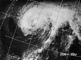
Hurricane Agnes was the first tropical storm and first hurricane of the 1972 Atlantic hurricane season
. A rare June hurricane, it made landfall on the Florida Panhandle before moving northeastward and ravaging the Mid-Atlantic
region as a tropical storm. The worst damage occurred along a swath from central Virginia
through central Pennsylvania
to the southern Finger Lakes
region of New York
, as illustrated by the rainfall map below. Agnes brought heavy rainfall along its path, killing 129 and causing $3 billion in damage, with railroad damage so extensive it contributed to the creation of Conrail. At the time, it was the most damaging hurricane ever recorded, surpassing Hurricane Betsy
, and it would not be surpassed until Hurricane Frederic
in 1979. Agnes was also the only Category 1 hurricane to have its name retired at the time. (Category 1 storms since to have retired names are Cesar
, Klaus
, Noel
, and Stan
).
Peninsula of Mexico on June 14. The system drifted eastward and became a tropical depression later that day and a tropical storm over the northwestern Caribbean on the 16th. Agnes turned northward on June 17 and became a hurricane over the southeastern Gulf of Mexico
the next day. A continued northward motion brought Agnes to the Florida
Panhandle coast on June 19 as a Category 1 hurricane.
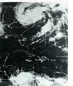
Agnes turned northeastward after landfall and weakened to a depression over Georgia
. However, it regained tropical storm strength over eastern North Carolina
on June 21 and moved into the Atlantic later that day. A northwestward turn followed, and a just-under-hurricane-strength Agnes made a final landfall on June 22 near New York City
. The storm merged with a non-tropical low on June 23, with the combined system affecting the northeastern United States
until June 25.
 Agnes was barely a hurricane at landfall in Florida
, and the effects of winds and storm surges were relatively minor. The major impact was over the Mid-Atlantic region, where Agnes combined with a non-tropical low to produce widespread rains of 6 to 12 inches (304.8 mm) with local amounts up to 19 inches (482.6 mm) in western Schuylkill County
in Pennsylvania
. These rains produced widespread severe flooding from Virginia
northward to New York
, with other flooding occurring over the western portions of the Carolinas. (from Hurricane Agnes Rainfall and Floods, June–July 1972)
Some of the worst flooding was along the Genesee River
, the Canisteo River
, and the Chemung River
in southwestern and south central New York. The latter two flow into the Susquehanna River
, and most of the severe flooding took place throughout the Chesapeake/Susquehanna watershed. Flooding set a flood record at, and threatened to overtop, the Conowingo Dam
near the mouth of the Susquehanna in Maryland
. The worst urban damage occurred in Elmira, New York
, Harrisburg, Pennsylvania
, and Wilkes-Barre, Pennsylvania
, but many other communities along the rivers suffered great losses. Dick Baumbach, a reporter for The Elmira Star Gazette, covered the hurricane and almost lost his life while he was attempting to take a photograph of the very rapidly rising flood waters in Wellsburg, New York. He went on to be awarded the Associated Press Meritorious Service Award for his coverage of the hurricane. The Delaware River
and Potomac River
basins also had some flooding. So much fresh water was flushed into Chesapeake Bay that its seafood industry was badly damaged for several years; freshwater intolerant species such as jellyfish became largely non-existent in the upper and mid bay.
Rainfall in the Piedmont
regions of Maryland and Virginia caused extensive flooding in the Patapsco
, Potomac
and James
River basins. Areas along the James west of Richmond
and east of the Blue Ridge Mountains
received massive amounts of rainfall that exceeded the rains of Hurricane Camille
three years prior. The river experienced five-hundred year flooding levels, inundating downtown Richmond and causing millions of dollars in damages. The swollen Patapsco River
swept away houses and ten miles (16 km) of train tracks, blocking at one point every transportation route southward out of Baltimore into neighboring Anne Arundel County, Maryland
toward Annapolis. Maryland had the highest per capita death toll of all five states declared disaster areas by President Nixon (Florida, Virginia, Maryland, Pennsylvania, and New York). Extensive flooding was recorded even as far inland as Pittsburgh
and throughout the Ohio River Valley, where rivers crested 11 feet (3.4 m) above flood stage on June 24 after nearly a foot of rain fell in parts of Western Pennsylvania
over the course of three days.
Agnes caused 122 deaths in the United States. Nine of these were in Florida (mainly from severe thunderstorms) while the remainder were associated with the flooding. The storm was responsible for $2.1 billion in damage (1972 US dollars) in the United States, the vast majority of which came from the flooding. Of this, over $2 billion was in Pennsylvania, and $700 million in New York. Agnes also affected western Cuba
, where seven additional deaths occurred.
At the time it hit, Agnes was the costliest storm ever to impact the United States. Currently, after adjustment for inflation, Agnes is the seventh costliest storm in United States history with a total of $11.6 billion (2005 US dollars). It is still the worst natural disaster, in terms of damages and lives lost, in Pennsylvania's history.
In Canada
, Hurricane Agnes gave heavy rains and winds over southern Ontario
and southern Quebec
, causing numerous floodings around Lake Erie
and Lake Ontario
. In the town of Maniwaki, Quebec, the storm toppled a mobile home, killing two people.
 Agnes had a devastating impact on the already-bankrupt railroads in the northeastern United States, as lines were washed out and shipments were delayed. The resulting cost of repairing the damage was one of the factors leading to the creation of the federally financed Conrail
railroad system.
The severe floods near Lawrenceville, Pennsylvania were the catalyst for the construction of the Tioga Reservoir
in 1973. The flooding in Wilkes-Barre, Pennsylvania
and the adjacent town of Kingston
led to the construction of a levee
system that in 2006 successfully prevented massive flooding and, in the same year, was deemed very safe and protective by the Army Corps of Engineers. Conversely, the existing Kinzua Dam
, built against the wishes of the Seneca Nation of New York
, spared much of Western Pennsylvania
from the worst flooding, by filling the Allegheny Reservoir
to capacity.
1972 Atlantic hurricane season
The 1972 Atlantic hurricane season officially began on June 1, 1972, and lasted until November 30, 1972. These dates conventionally delimit the period of each year when most tropical cyclones form in the Atlantic basin. A strong El Niño kept hurricane activity at a minimum, and in fact the season...
. A rare June hurricane, it made landfall on the Florida Panhandle before moving northeastward and ravaging the Mid-Atlantic
Mid-Atlantic States
The Mid-Atlantic states, also called middle Atlantic states or simply the mid Atlantic, form a region of the United States generally located between New England and the South...
region as a tropical storm. The worst damage occurred along a swath from central Virginia
Virginia
The Commonwealth of Virginia , is a U.S. state on the Atlantic Coast of the Southern United States. Virginia is nicknamed the "Old Dominion" and sometimes the "Mother of Presidents" after the eight U.S. presidents born there...
through central Pennsylvania
Pennsylvania
The Commonwealth of Pennsylvania is a U.S. state that is located in the Northeastern and Mid-Atlantic regions of the United States. The state borders Delaware and Maryland to the south, West Virginia to the southwest, Ohio to the west, New York and Ontario, Canada, to the north, and New Jersey to...
to the southern Finger Lakes
Finger Lakes
The Finger Lakes are a pattern of lakes in the west-central section of Upstate New York in the United States. They are a popular tourist destination. The lakes are long and thin , each oriented roughly on a north-south axis. The two longest, Cayuga Lake and Seneca Lake, are among the deepest in...
region of New York
New York
New York is a state in the Northeastern region of the United States. It is the nation's third most populous state. New York is bordered by New Jersey and Pennsylvania to the south, and by Connecticut, Massachusetts and Vermont to the east...
, as illustrated by the rainfall map below. Agnes brought heavy rainfall along its path, killing 129 and causing $3 billion in damage, with railroad damage so extensive it contributed to the creation of Conrail. At the time, it was the most damaging hurricane ever recorded, surpassing Hurricane Betsy
Hurricane Betsy
Hurricane Betsy was a Category 4 hurricane of the 1965 Atlantic hurricane season which caused enormous damage in the Bahamas, Florida, and Louisiana. Betsy made its most intense landfall near the mouth of the Mississippi River, causing significant flooding of the waters of Lake Pontchartrain into...
, and it would not be surpassed until Hurricane Frederic
Hurricane Frederic
Hurricane Frederic was the sixth tropical cyclone, third hurricane and second major hurricane of the 1979 Atlantic hurricane season. Frederic was the costliest hurricane to ever hit the U.S. Gulf Coast at that particular time...
in 1979. Agnes was also the only Category 1 hurricane to have its name retired at the time. (Category 1 storms since to have retired names are Cesar
Hurricane Cesar-Douglas
Hurricane Cesar–Douglas was a devastating tropical cyclone that killed 122 people throughout Central and South America in late-July 1996. The Category 1 hurricane formed in late July in the Caribbean Sea and pounded Central America with rain, killing 67 people and causing local governments to deem...
, Klaus
Hurricane Klaus
Hurricane Klaus was a minimal Atlantic hurricane that dropped heavy rainfall across the Lesser Antilles in October 1990. The eleventh tropical cyclone and sixth hurricane of the 1990 Atlantic hurricane season, Klaus developed from a tropical wave on October 3 a short distance east of Dominica. It...
, Noel
Hurricane Noel
The name Noel has been used for three tropical cyclones in the Atlantic Ocean.* 1995's Hurricane Noel - reached hurricane strength far from land and was absorbed by a cold front without threatening land....
, and Stan
Hurricane Stan
Hurricane Stan was the eighteenth named tropical storm and eleventh hurricane of the 2005 Atlantic hurricane season. It was also the sixth of seven tropical cyclones to make landfall in Mexico. Stan was a relatively weak storm that only briefly reached hurricane status...
).
Meteorological history
The large disturbance was first detected over the YucatánYucatán
Yucatán officially Estado Libre y Soberano de Yucatán is one of the 31 states which, with the Federal District, comprise the 32 Federal Entities of Mexico. It is divided in 106 municipalities and its capital city is Mérida....
Peninsula of Mexico on June 14. The system drifted eastward and became a tropical depression later that day and a tropical storm over the northwestern Caribbean on the 16th. Agnes turned northward on June 17 and became a hurricane over the southeastern Gulf of Mexico
Gulf of Mexico
The Gulf of Mexico is a partially landlocked ocean basin largely surrounded by the North American continent and the island of Cuba. It is bounded on the northeast, north and northwest by the Gulf Coast of the United States, on the southwest and south by Mexico, and on the southeast by Cuba. In...
the next day. A continued northward motion brought Agnes to the Florida
Florida
Florida is a state in the southeastern United States, located on the nation's Atlantic and Gulf coasts. It is bordered to the west by the Gulf of Mexico, to the north by Alabama and Georgia and to the east by the Atlantic Ocean. With a population of 18,801,310 as measured by the 2010 census, it...
Panhandle coast on June 19 as a Category 1 hurricane.
Agnes turned northeastward after landfall and weakened to a depression over Georgia
Georgia (U.S. state)
Georgia is a state located in the southeastern United States. It was established in 1732, the last of the original Thirteen Colonies. The state is named after King George II of Great Britain. Georgia was the fourth state to ratify the United States Constitution, on January 2, 1788...
. However, it regained tropical storm strength over eastern North Carolina
North Carolina
North Carolina is a state located in the southeastern United States. The state borders South Carolina and Georgia to the south, Tennessee to the west and Virginia to the north. North Carolina contains 100 counties. Its capital is Raleigh, and its largest city is Charlotte...
on June 21 and moved into the Atlantic later that day. A northwestward turn followed, and a just-under-hurricane-strength Agnes made a final landfall on June 22 near New York City
New York City
New York is the most populous city in the United States and the center of the New York Metropolitan Area, one of the most populous metropolitan areas in the world. New York exerts a significant impact upon global commerce, finance, media, art, fashion, research, technology, education, and...
. The storm merged with a non-tropical low on June 23, with the combined system affecting the northeastern United States
United States
The United States of America is a federal constitutional republic comprising fifty states and a federal district...
until June 25.
Impact
Florida
Florida is a state in the southeastern United States, located on the nation's Atlantic and Gulf coasts. It is bordered to the west by the Gulf of Mexico, to the north by Alabama and Georgia and to the east by the Atlantic Ocean. With a population of 18,801,310 as measured by the 2010 census, it...
, and the effects of winds and storm surges were relatively minor. The major impact was over the Mid-Atlantic region, where Agnes combined with a non-tropical low to produce widespread rains of 6 to 12 inches (304.8 mm) with local amounts up to 19 inches (482.6 mm) in western Schuylkill County
Schuylkill County, Pennsylvania
-Notable people:*Boxing heavyweight great Muhammad Ali had his training camp in Deer Lake.*Charles Justin Bailey, commanding general of the 81st Division in World War I, was born in Tamaqua on June 21, 1859....
in Pennsylvania
Pennsylvania
The Commonwealth of Pennsylvania is a U.S. state that is located in the Northeastern and Mid-Atlantic regions of the United States. The state borders Delaware and Maryland to the south, West Virginia to the southwest, Ohio to the west, New York and Ontario, Canada, to the north, and New Jersey to...
. These rains produced widespread severe flooding from Virginia
Virginia
The Commonwealth of Virginia , is a U.S. state on the Atlantic Coast of the Southern United States. Virginia is nicknamed the "Old Dominion" and sometimes the "Mother of Presidents" after the eight U.S. presidents born there...
northward to New York
New York
New York is a state in the Northeastern region of the United States. It is the nation's third most populous state. New York is bordered by New Jersey and Pennsylvania to the south, and by Connecticut, Massachusetts and Vermont to the east...
, with other flooding occurring over the western portions of the Carolinas. (from Hurricane Agnes Rainfall and Floods, June–July 1972)
| Area | Deaths |
|---|---|
| Canada Canada Canada is a North American country consisting of ten provinces and three territories. Located in the northern part of the continent, it extends from the Atlantic Ocean in the east to the Pacific Ocean in the west, and northward into the Arctic Ocean... |
2 |
| Cuba Cuba The Republic of Cuba is an island nation in the Caribbean. The nation of Cuba consists of the main island of Cuba, the Isla de la Juventud, and several archipelagos. Havana is the largest city in Cuba and the country's capital. Santiago de Cuba is the second largest city... |
9 |
| Florida Florida Florida is a state in the southeastern United States, located on the nation's Atlantic and Gulf coasts. It is bordered to the west by the Gulf of Mexico, to the north by Alabama and Georgia and to the east by the Atlantic Ocean. With a population of 18,801,310 as measured by the 2010 census, it... |
9 |
| North Carolina North Carolina North Carolina is a state located in the southeastern United States. The state borders South Carolina and Georgia to the south, Tennessee to the west and Virginia to the north. North Carolina contains 100 counties. Its capital is Raleigh, and its largest city is Charlotte... |
2 |
| Virginia Virginia The Commonwealth of Virginia , is a U.S. state on the Atlantic Coast of the Southern United States. Virginia is nicknamed the "Old Dominion" and sometimes the "Mother of Presidents" after the eight U.S. presidents born there... |
13 |
| Delaware Delaware Delaware is a U.S. state located on the Atlantic Coast in the Mid-Atlantic region of the United States. It is bordered to the south and west by Maryland, and to the north by Pennsylvania... |
1 |
| Maryland Maryland Maryland is a U.S. state located in the Mid Atlantic region of the United States, bordering Virginia, West Virginia, and the District of Columbia to its south and west; Pennsylvania to its north; and Delaware to its east... |
19 |
| New Jersey New Jersey New Jersey is a state in the Northeastern and Middle Atlantic regions of the United States. , its population was 8,791,894. It is bordered on the north and east by the state of New York, on the southeast and south by the Atlantic Ocean, on the west by Pennsylvania and on the southwest by Delaware... |
1 |
| New York New York New York is a state in the Northeastern region of the United States. It is the nation's third most populous state. New York is bordered by New Jersey and Pennsylvania to the south, and by Connecticut, Massachusetts and Vermont to the east... |
24 |
| Pennsylvania Pennsylvania The Commonwealth of Pennsylvania is a U.S. state that is located in the Northeastern and Mid-Atlantic regions of the United States. The state borders Delaware and Maryland to the south, West Virginia to the southwest, Ohio to the west, New York and Ontario, Canada, to the north, and New Jersey to... |
50 |
| Total | 130 |
Some of the worst flooding was along the Genesee River
Genesee River
The Genesee River is a North American river flowing northward through the Twin Tiers of Pennsylvania and New York. The river provided the original power for the Rochester area's 19th century mills and still provides hydroelectric power for downtown Rochester....
, the Canisteo River
Canisteo River
The Canisteo River is a tributary of the Tioga River in western New York in the United States. It drains a dissected plateau, a portion of the northern Allegheny Plateau southwest of the Finger Lakes region, in the far northwestern reaches of the watershed of the Susquehanna River.It rises in the...
, and the Chemung River
Chemung River
The Chemung River is a tributary of the Susquehanna River, approximately long, in south central New York and northern Pennsylvania in the United States. It drains a mountainous region of the northern Allegheny Plateau in the Southern Tier of New York...
in southwestern and south central New York. The latter two flow into the Susquehanna River
Susquehanna River
The Susquehanna River is a river located in the northeastern United States. At long, it is the longest river on the American east coast that drains into the Atlantic Ocean, and with its watershed it is the 16th largest river in the United States, and the longest river in the continental United...
, and most of the severe flooding took place throughout the Chesapeake/Susquehanna watershed. Flooding set a flood record at, and threatened to overtop, the Conowingo Dam
Conowingo Dam
The Conowingo Dam is a large hydroelectric dam in the Lower Susquehanna River. The dam, one of the largest non-federal hydroelectric dams in the US, is classified as a medium height, masonry gravity type dam...
near the mouth of the Susquehanna in Maryland
Maryland
Maryland is a U.S. state located in the Mid Atlantic region of the United States, bordering Virginia, West Virginia, and the District of Columbia to its south and west; Pennsylvania to its north; and Delaware to its east...
. The worst urban damage occurred in Elmira, New York
Elmira, New York
Elmira is a city in Chemung County, New York, USA. It is the principal city of the 'Elmira, New York Metropolitan Statistical Area' which encompasses Chemung County, New York. The population was 29,200 at the 2010 census. It is the county seat of Chemung County.The City of Elmira is located in...
, Harrisburg, Pennsylvania
Harrisburg, Pennsylvania
Harrisburg is the capital of Pennsylvania. As of the 2010 census, the city had a population of 49,528, making it the ninth largest city in Pennsylvania...
, and Wilkes-Barre, Pennsylvania
Wilkes-Barre, Pennsylvania
Wilkes-Barre is a city in the U.S. state of Pennsylvania, the county seat of Luzerne County. It is at the center of the Wyoming Valley area and is one of the principal cities in the Scranton/Wilkes-Barre metropolitan area, which had a population of 563,631 as of the 2010 Census...
, but many other communities along the rivers suffered great losses. Dick Baumbach, a reporter for The Elmira Star Gazette, covered the hurricane and almost lost his life while he was attempting to take a photograph of the very rapidly rising flood waters in Wellsburg, New York. He went on to be awarded the Associated Press Meritorious Service Award for his coverage of the hurricane. The Delaware River
Delaware River
The Delaware River is a major river on the Atlantic coast of the United States.A Dutch expedition led by Henry Hudson in 1609 first mapped the river. The river was christened the South River in the New Netherland colony that followed, in contrast to the North River, as the Hudson River was then...
and Potomac River
Potomac River
The Potomac River flows into the Chesapeake Bay, located along the mid-Atlantic coast of the United States. The river is approximately long, with a drainage area of about 14,700 square miles...
basins also had some flooding. So much fresh water was flushed into Chesapeake Bay that its seafood industry was badly damaged for several years; freshwater intolerant species such as jellyfish became largely non-existent in the upper and mid bay.
Rainfall in the Piedmont
Piedmont (United States)
The Piedmont is a plateau region located in the eastern United States between the Atlantic Coastal Plain and the main Appalachian Mountains, stretching from New Jersey in the north to central Alabama in the south. The Piedmont province is a physiographic province of the larger Appalachian division...
regions of Maryland and Virginia caused extensive flooding in the Patapsco
Patapsco River
The Patapsco River is a river in central Maryland which flows into Chesapeake Bay. The river's tidal portion forms the harbor for the city of Baltimore...
, Potomac
Potomac River
The Potomac River flows into the Chesapeake Bay, located along the mid-Atlantic coast of the United States. The river is approximately long, with a drainage area of about 14,700 square miles...
and James
James River (Virginia)
The James River is a river in the U.S. state of Virginia. It is long, extending to if one includes the Jackson River, the longer of its two source tributaries. The James River drains a catchment comprising . The watershed includes about 4% open water and an area with a population of 2.5 million...
River basins. Areas along the James west of Richmond
Richmond, Virginia
Richmond is the capital of the Commonwealth of Virginia, in the United States. It is an independent city and not part of any county. Richmond is the center of the Richmond Metropolitan Statistical Area and the Greater Richmond area...
and east of the Blue Ridge Mountains
Blue Ridge Mountains
The Blue Ridge Mountains are a physiographic province of the larger Appalachian Mountains range. This province consists of northern and southern physiographic regions, which divide near the Roanoke River gap. The mountain range is located in the eastern United States, starting at its southern-most...
received massive amounts of rainfall that exceeded the rains of Hurricane Camille
Hurricane Camille
Hurricane Camille was the third and strongest tropical cyclone and second hurricane during the 1969 Atlantic hurricane season. The second of three catastrophic Category 5 hurricanes to make landfall in the United States during the 20th century , which it did near the mouth of the Mississippi River...
three years prior. The river experienced five-hundred year flooding levels, inundating downtown Richmond and causing millions of dollars in damages. The swollen Patapsco River
Patapsco River
The Patapsco River is a river in central Maryland which flows into Chesapeake Bay. The river's tidal portion forms the harbor for the city of Baltimore...
swept away houses and ten miles (16 km) of train tracks, blocking at one point every transportation route southward out of Baltimore into neighboring Anne Arundel County, Maryland
Anne Arundel County, Maryland
Anne Arundel County is a county located in the U.S. state of Maryland. It is named for Anne Arundell , a member of the ancient family of Arundells in Cornwall, England and the wife of Cæcilius Calvert, 2nd Baron Baltimore. Its county seat is Annapolis, which is also the capital of the state...
toward Annapolis. Maryland had the highest per capita death toll of all five states declared disaster areas by President Nixon (Florida, Virginia, Maryland, Pennsylvania, and New York). Extensive flooding was recorded even as far inland as Pittsburgh
Pittsburgh, Pennsylvania
Pittsburgh is the second-largest city in the US Commonwealth of Pennsylvania and the county seat of Allegheny County. Regionally, it anchors the largest urban area of Appalachia and the Ohio River Valley, and nationally, it is the 22nd-largest urban area in the United States...
and throughout the Ohio River Valley, where rivers crested 11 feet (3.4 m) above flood stage on June 24 after nearly a foot of rain fell in parts of Western Pennsylvania
Western Pennsylvania
Western Pennsylvania consists of the western third of the state of Pennsylvania in the United States. Pittsburgh is the largest city in the region, with a metropolitan area population of about 2.4 million people, and serves as its economic and cultural center. Erie, Altoona, and Johnstown are its...
over the course of three days.
Agnes caused 122 deaths in the United States. Nine of these were in Florida (mainly from severe thunderstorms) while the remainder were associated with the flooding. The storm was responsible for $2.1 billion in damage (1972 US dollars) in the United States, the vast majority of which came from the flooding. Of this, over $2 billion was in Pennsylvania, and $700 million in New York. Agnes also affected western Cuba
Cuba
The Republic of Cuba is an island nation in the Caribbean. The nation of Cuba consists of the main island of Cuba, the Isla de la Juventud, and several archipelagos. Havana is the largest city in Cuba and the country's capital. Santiago de Cuba is the second largest city...
, where seven additional deaths occurred.
At the time it hit, Agnes was the costliest storm ever to impact the United States. Currently, after adjustment for inflation, Agnes is the seventh costliest storm in United States history with a total of $11.6 billion (2005 US dollars). It is still the worst natural disaster, in terms of damages and lives lost, in Pennsylvania's history.
In Canada
Canada
Canada is a North American country consisting of ten provinces and three territories. Located in the northern part of the continent, it extends from the Atlantic Ocean in the east to the Pacific Ocean in the west, and northward into the Arctic Ocean...
, Hurricane Agnes gave heavy rains and winds over southern Ontario
Ontario
Ontario is a province of Canada, located in east-central Canada. It is Canada's most populous province and second largest in total area. It is home to the nation's most populous city, Toronto, and the nation's capital, Ottawa....
and southern Quebec
Quebec
Quebec or is a province in east-central Canada. It is the only Canadian province with a predominantly French-speaking population and the only one whose sole official language is French at the provincial level....
, causing numerous floodings around Lake Erie
Lake Erie
Lake Erie is the fourth largest lake of the five Great Lakes in North America, and the tenth largest globally. It is the southernmost, shallowest, and smallest by volume of the Great Lakes and therefore also has the shortest average water residence time. It is bounded on the north by the...
and Lake Ontario
Lake Ontario
Lake Ontario is one of the five Great Lakes of North America. It is bounded on the north and southwest by the Canadian province of Ontario, and on the south by the American state of New York. Ontario, Canada's most populous province, was named for the lake. In the Wyandot language, ontarío means...
. In the town of Maniwaki, Quebec, the storm toppled a mobile home, killing two people.
Aftermath
Consolidated Rail Corporation
The Consolidated Rail Corporation, commonly known as Conrail , was the primary Class I railroad in the Northeast U.S. between 1976 and 1999. The federal government created it to take over the potentially profitable lines of bankrupt carriers, including the Penn Central Transportation Company and...
railroad system.
The severe floods near Lawrenceville, Pennsylvania were the catalyst for the construction of the Tioga Reservoir
Tioga River (Chemung River)
The Tioga River is a tributary of the Chemung River, approximately long, in northern Pennsylvania and western New York in the United States...
in 1973. The flooding in Wilkes-Barre, Pennsylvania
Wilkes-Barre, Pennsylvania
Wilkes-Barre is a city in the U.S. state of Pennsylvania, the county seat of Luzerne County. It is at the center of the Wyoming Valley area and is one of the principal cities in the Scranton/Wilkes-Barre metropolitan area, which had a population of 563,631 as of the 2010 Census...
and the adjacent town of Kingston
Kingston, Pennsylvania
Kingston is a municipality located in Luzerne County, Pennsylvania, United States, on the Susquehanna River opposite Wilkes Barre. Kingston was incorporated as a borough in 1857. Kingston has adopted a home rule charter which became effective in January 1976. It is part of the greater metropolitan...
led to the construction of a levee
Levee
A levee, levée, dike , embankment, floodbank or stopbank is an elongated naturally occurring ridge or artificially constructed fill or wall, which regulates water levels...
system that in 2006 successfully prevented massive flooding and, in the same year, was deemed very safe and protective by the Army Corps of Engineers. Conversely, the existing Kinzua Dam
Kinzua Dam
The Kinzua Dam, in the Allegheny National Forest in Warren County, Pennsylvania, is one of the largest dams in the United States east of the Mississippi River....
, built against the wishes of the Seneca Nation of New York
Seneca Nation of New York
The Seneca Nation of New York, also known as the Seneca Nation of Indians is a federally recognized tribe of Seneca people in New York...
, spared much of Western Pennsylvania
Western Pennsylvania
Western Pennsylvania consists of the western third of the state of Pennsylvania in the United States. Pittsburgh is the largest city in the region, with a metropolitan area population of about 2.4 million people, and serves as its economic and cultural center. Erie, Altoona, and Johnstown are its...
from the worst flooding, by filling the Allegheny Reservoir
Allegheny Reservoir
The Allegheny Reservoir is a reservoir along the Allegheny River in Pennsylvania and New York, USA. It was created in 1965 by the construction of the Kinzua Dam along the river.-History:...
to capacity.
Retirement
Because of extensive damage and severe death tolls, the name Agnes was retired following this storm, and will never again be used for another Atlantic hurricane. Because the tropical cyclone naming lists were changed in 1979, there was no replacement name selected. This is the first hurricane to have its name retired without reaching major hurricane (Category 3 or greater) as the 1972 season never produced major hurricanes.See also
- List of Atlantic hurricanes
- List of retired Atlantic hurricane names
- List of wettest tropical cyclones in the United States
- Timeline of the 1972 Atlantic hurricane seasonTimeline of the 1972 Atlantic hurricane seasonThe 1972 Atlantic hurricane season is one of four Atlantic hurricane seasons not to have any major hurricanes, the others being the 1968 season, the 1986 season, and the 1994 season. During the season, seven tropical or subtropical depressions formed, all of which became tropical or subtropical...
- List of Delaware hurricanes
Books
J. F. Bailey, J. L. Patterson, and J. L. H. Paulhus. Geological Survey Professional Paper 924. Hurricane Agnes Rainfall and Floods, June–July 1972. United States Government Printing Office: Washington D.C., 1975.External links
- Listen online – The Story of Hurricane Agnes - The American Storyteller Radio Journal
- National Hurricane Center web site for Agnes. This US government site is in the public domainPublic domainWorks are in the public domain if the intellectual property rights have expired, if the intellectual property rights are forfeited, or if they are not covered by intellectual property rights at all...
. - HPC Rainfall Site for Agnes
- United States Railway Association final system plan for reconstructing railroads in the northeast and midwest region pursuant to the Regional Rail Reorganization Act of 1973
- FAQ: Hurricanes, Typhoons, and Tropical Cyclones, NOAA, retrieved January 26, 2006.
- Agnes in Northeastern Pennsylvania