
.gif)
Tropical Storm Arlene (2005)
Encyclopedia
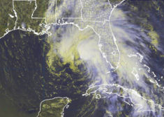
Tropical Storm Arlene was an unusually large and early-forming tropical storm forming during the 2005 Atlantic hurricane season
. It was the first storm of the season, which would become the most active on record. Tropical Storm Arlene formed near Honduras
on June 8 and moved northwards. It crossed western Cuba
on June 10 and strengthened to just under hurricane strength before making its final landfall on the Florida Panhandle
the next day. The storm weakened as it continued to move north over the United States
, becoming extratropical on June 13. Arlene was responsible for only one death and minor damages.
. Despite significant shear, the low managed to become Tropical Depression One on June 8 just north of Honduras. The depression began to head north towards western Cuba
that day, but as it was a very large and poorly organized system under the influence of heavy shear, the official forecasts from the National Hurricane Center
emphasized that the route the storm would take was uncertain. Despite this uncertainty, the official forecasts were highly accurate in predicting the storm's track.
As the shear dropped, the depression strengthened further and it became Tropical Storm Arlene on June 9. It produced precipitation over a very wide area; the Cayman Islands
reported tropical storm-force winds and heavy rain over 150 statute miles (240 km) east of the center. Arlene crossed the western tip of Cuba on the morning of June 10 with 50 mph (85 km/h) winds. Tropical Storm Arlene had an unusual structure throughout its life, with a large circulation containing numerous small centers rotating about a larger gyre
, as opposed to an inner convective core.
 Tropical Storm Arlene then entered the Gulf of Mexico
and strengthened further to its peak strength with 70 mph (110 km/h) winds. The official forecast at this time called for further intensification to minimal hurricane strength. This did not occur however and Arlene instead weakened as result of dry air entering the circulation. The storm made landfall just west of Pensacola, Florida
in the afternoon of June 11 with 57.5 mph (95 km/h) winds. As most of the precipitation and wind of the storm were located north and east of the center, most of the effects of the storm were on land long before it made landfall.
Arlene was the most intense landfalling June storm since Hurricane Allison hit the same location as a strong tropical storm during the 1995 season
. Arlene weakened into a tropical depression later that day, but managed to persist as a tropical system as it moved north over the United States. The system finally became extratropical on June 13 just northeast of Flint, Michigan
and was absorbed by a larger system the next day.
were issued for western Cuba
, the Caymans, and the Dry Tortugas
before the landfall on Cuba on June 10. While Arlene was over Cuba a tropical storm watch was issued for the Gulf Coast from Morgan City, Louisiana
to Indian Pass, Florida
. A tropical storm warning was issued for a stretch of coast slightly further east than the area covered by the preceding watch, and a hurricane watch was issued for the central section of this region. This turned into a hurricane warning from Pearl River, Louisiana
to Indian Pass due to fears of a strengthening to hurricane strength. The warnings were reduced and were then canceled eight hours after the second landfall.
Florida Governor Jeb Bush
issued a state of emergency two days before the storm's final landfall. Recovery teams were also deployed for the area. An evacuation order was issued for all areas south of the Gulf Coast Highway, including Pensacola Beach
, Perdido Key, and Inerarity Point. Walton County
officials issued a voluntary evacuation for low line areas and mobile homes. Walton County also opened a shelter in Freeport
, and four shelters and one special needs shelter were opened in Escambia County
.
Two days prior to landfall, 36 oil platforms and 16 rigs were evacuated. The cumulative production loss caused from the evacuation of the storm totalled 0.109% of the yearly production, approximately 575 million barrels. The stopped rigs also accounted for 3.87% of the daily production on June 13.
in Miami Beach, Florida
, far from the center of circulation.
 In the Florida Keys
, Arlene produced wind gusts of up to 60 mph (95 km/h), causing wind damage to four homes in Lower Matecumbe Key
. The storm caused a storm surge of 1.25 feet (0.38 m) above normal. Waves on top of the surge caused flooding on roads in Key West
. Damage in the Florida Keys totaled to $90,000 (2005 USD).
In the Florida Panhandle
, the storm dropped heavy rainfall, peaking at 8.51 inches (216 mm) in Plantation Bay, Florida in Flagler County
. Upon making landfall, Arlene caused a storm surge of up to 5 feet (1.5 m) in Walton County
. Moderate beach erosion also occurred. The storm surge and strong waves caused moderate to severe damage to roads along the panhandle. Strong winds caused power outages to 500 people in Walton, Washington
and Bay
counties. The storm spawned a weak tornado
in Navarre, Florida
, causing minor damage on its 0.1-mile (0.2-km) path. Damage on the panhandle totaled to $3.5 million (2005 USD), $2.5 million of which was in Fort Pickens
alone.
, with higher totals of up to eight inches (200 mm) to the west of Interstate 65
. Four to six inches (152 mm) of rain fell in a three hour period in the Mobile
area. Several roads were temporarily impassable from the flooding, and one road was completely washed away. Wind speeds were around 20 to 30 mph (30 to 50 km/h), while wind gusts of over 60 mph (95 km/h) existed. The winds downed several trees and power lines, leaving thousands without power for several hours. With the storm following a path similar to Hurricane Ivan
just nine months earlier, many trees damaged from Ivan were downed completely. In addition, several homes experienced light wind damage. The outer bands of the storm also caused numerous funnel clouds, though no tornadoes were reported. Overall, damage was light, amounting to $1.7 million (2005 USD).
forced multiple residents to evacuate from rising flood water. Numerous creeks and rivers in the northern portion of the state overflowed.
Tropical Storm Arlene caused light rainfall across southeastern Mississippi
, typically between 1 to 2 inches (25 to 50 mm). Effects were generally minimal.
In Indiana
, the remnants of Arlene dropped heavy rainfall, peaking at 4.44 inches (112.8 mm) in Evansville
. In Indianapolis
, 3.04 inches (75 mm) fell at the International Airport
. Rainfall from the storm was 85% of the typical June rainfall level. Arlene also spawned two tornadoes. An F1
tornado developed to the southwest of Hayden
on June 12. The tornado damaged several buildings and trees on its 5.3-mile (8.5-km) path, with total damage amounting to $100,000 (2005 USD). Outer rainbands also developed an F0 tornado just south of Indianapolis
, downing a few tree limbs.
The remnants of Arlene combined with a non-tropical system caused heavy rainfall across New York
, with some locations reporting 6 to 7 inches (150 to 175 mm) of precipitation in a 2-hour period. The rainfall collected into streams and rivers, with some officials calling it a 1 in 500 year flood. The flash flooding caused at least one mudslide, and damaged several roads. The flooding forced at least 20 to evacuate from their homes, and numerous houses were damaged. Strong winds also downed trees and power lines, causing scattered power outages. Damage totaled to $6.5 million (2005 USD).
2005 Atlantic hurricane season
The 2005 Atlantic hurricane season was the most active Atlantic hurricane season in recorded history, repeatedly shattering numerous records. The impact of the season was widespread and ruinous with an estimated 3,913 deaths and record damage of about $159.2 billion...
. It was the first storm of the season, which would become the most active on record. Tropical Storm Arlene formed near Honduras
Honduras
Honduras is a republic in Central America. It was previously known as Spanish Honduras to differentiate it from British Honduras, which became the modern-day state of Belize...
on June 8 and moved northwards. It crossed western Cuba
Cuba
The Republic of Cuba is an island nation in the Caribbean. The nation of Cuba consists of the main island of Cuba, the Isla de la Juventud, and several archipelagos. Havana is the largest city in Cuba and the country's capital. Santiago de Cuba is the second largest city...
on June 10 and strengthened to just under hurricane strength before making its final landfall on the Florida Panhandle
Florida Panhandle
The Florida Panhandle, an informal, unofficial term for the northwestern part of Florida, is a strip of land roughly 200 miles long and 50 to 100 miles wide , lying between Alabama on the north and the west, Georgia also on the north, and the Gulf of Mexico to the south. Its eastern boundary is...
the next day. The storm weakened as it continued to move north over the United States
United States
The United States of America is a federal constitutional republic comprising fifty states and a federal district...
, becoming extratropical on June 13. Arlene was responsible for only one death and minor damages.
Meteorological history
Early in the season — nearly two months earlier than the first storm formation in 2004 — a low-pressure area formed and persisted north of HondurasHonduras
Honduras is a republic in Central America. It was previously known as Spanish Honduras to differentiate it from British Honduras, which became the modern-day state of Belize...
. Despite significant shear, the low managed to become Tropical Depression One on June 8 just north of Honduras. The depression began to head north towards western Cuba
Cuba
The Republic of Cuba is an island nation in the Caribbean. The nation of Cuba consists of the main island of Cuba, the Isla de la Juventud, and several archipelagos. Havana is the largest city in Cuba and the country's capital. Santiago de Cuba is the second largest city...
that day, but as it was a very large and poorly organized system under the influence of heavy shear, the official forecasts from the National Hurricane Center
National Hurricane Center
The National Hurricane Center , located at Florida International University in Miami, Florida, is the division of the National Weather Service responsible for tracking and predicting weather systems within the tropics between the Prime Meridian and the 140th meridian west poleward to the 30th...
emphasized that the route the storm would take was uncertain. Despite this uncertainty, the official forecasts were highly accurate in predicting the storm's track.
As the shear dropped, the depression strengthened further and it became Tropical Storm Arlene on June 9. It produced precipitation over a very wide area; the Cayman Islands
Cayman Islands
The Cayman Islands is a British Overseas Territory and overseas territory of the European Union located in the western Caribbean Sea. The territory comprises the three islands of Grand Cayman, Cayman Brac, and Little Cayman, located south of Cuba and northwest of Jamaica...
reported tropical storm-force winds and heavy rain over 150 statute miles (240 km) east of the center. Arlene crossed the western tip of Cuba on the morning of June 10 with 50 mph (85 km/h) winds. Tropical Storm Arlene had an unusual structure throughout its life, with a large circulation containing numerous small centers rotating about a larger gyre
Gyre
A gyre in oceanography is any large system of rotating ocean currents, particularly those involved with large wind movements. Gyres are caused by the Coriolis Effect; planetary vorticity along with horizontal and vertical friction, which determine the circulation patterns from the wind curl...
, as opposed to an inner convective core.
Gulf of Mexico
The Gulf of Mexico is a partially landlocked ocean basin largely surrounded by the North American continent and the island of Cuba. It is bounded on the northeast, north and northwest by the Gulf Coast of the United States, on the southwest and south by Mexico, and on the southeast by Cuba. In...
and strengthened further to its peak strength with 70 mph (110 km/h) winds. The official forecast at this time called for further intensification to minimal hurricane strength. This did not occur however and Arlene instead weakened as result of dry air entering the circulation. The storm made landfall just west of Pensacola, Florida
Pensacola, Florida
Pensacola is the westernmost city in the Florida Panhandle and the county seat of Escambia County, Florida, United States of America. As of the 2000 census, the city had a total population of 56,255 and as of 2009, the estimated population was 53,752...
in the afternoon of June 11 with 57.5 mph (95 km/h) winds. As most of the precipitation and wind of the storm were located north and east of the center, most of the effects of the storm were on land long before it made landfall.
Arlene was the most intense landfalling June storm since Hurricane Allison hit the same location as a strong tropical storm during the 1995 season
1995 Atlantic hurricane season
The 1995 Atlantic hurricane season was the third most active Atlantic hurricane season on record. It officially began on June 1, 1995, and lasted until November 30, 1995. These dates conventionally delimit the period of each year when most tropical cyclones form in the north Atlantic ocean...
. Arlene weakened into a tropical depression later that day, but managed to persist as a tropical system as it moved north over the United States. The system finally became extratropical on June 13 just northeast of Flint, Michigan
Flint, Michigan
Flint is a city in the U.S. state of Michigan and is located along the Flint River, northwest of Detroit. The U.S. Census Bureau reports the 2010 population to be placed at 102,434, making Flint the seventh largest city in Michigan. It is the county seat of Genesee County which lies in the...
and was absorbed by a larger system the next day.
Preparations
Tropical storm warningsTropical cyclone warnings and watches
Warnings and watches are two levels of alert issued by national weather forecasting bodies to coastal areas threatened by the imminent approach of a tropical cyclone of tropical storm or hurricane intensity. They are notices to the local population and civil authorities to make appropriate...
were issued for western Cuba
Cuba
The Republic of Cuba is an island nation in the Caribbean. The nation of Cuba consists of the main island of Cuba, the Isla de la Juventud, and several archipelagos. Havana is the largest city in Cuba and the country's capital. Santiago de Cuba is the second largest city...
, the Caymans, and the Dry Tortugas
Dry Tortugas
The Dry Tortugas are a small group of islands, located at the end of the Florida Keys, USA, about west of Key West, and west of the Marquesas Keys, the closest islands. Still further west is the Tortugas Bank, which is completely submerged. The first Europeans to discover the islands were the...
before the landfall on Cuba on June 10. While Arlene was over Cuba a tropical storm watch was issued for the Gulf Coast from Morgan City, Louisiana
Morgan City, Louisiana
Morgan City is a city in St. Martin and St. Mary parishes in the U.S. state of Louisiana. The population was 12,404 at the 2010 census....
to Indian Pass, Florida
Indian Pass, Florida
Indian Pass is a small area on the south coast of Gulf County, Florida, 8 miles south of Port St. Joe. It promotes itself as an uncrowded haven for sports fisherman and water enthusiasts, and for dining featuring locally caught oysters. A ferry provides access to a wildlife sanctuary on St Vincent...
. A tropical storm warning was issued for a stretch of coast slightly further east than the area covered by the preceding watch, and a hurricane watch was issued for the central section of this region. This turned into a hurricane warning from Pearl River, Louisiana
Pearl River, Louisiana
Pearl River is a town in St. Tammany Parish, Louisiana, United States. The population was 1,839 at the 2000 census. It is part of the New Orleans–Metairie–Kenner Metropolitan Statistical Area.-Geography:...
to Indian Pass due to fears of a strengthening to hurricane strength. The warnings were reduced and were then canceled eight hours after the second landfall.
Florida Governor Jeb Bush
Jeb Bush
John Ellis "Jeb" Bush is an American politician who served as the 43rd Governor of Florida from 1999 to 2007. He is a prominent member of the Bush family: the second son of former President George H. W. Bush and former First Lady Barbara Bush; the younger brother of former President George W...
issued a state of emergency two days before the storm's final landfall. Recovery teams were also deployed for the area. An evacuation order was issued for all areas south of the Gulf Coast Highway, including Pensacola Beach
Pensacola Beach, Florida
Pensacola Beach is an unincorporated community located on Santa Rosa Island, a barrier island, in Escambia County, Florida, United States. It is situated south of Pensacola, and Gulf Breeze connected via bridges spanning to the Fairpoint Peninsula and then to the island, on the Gulf of Mexico...
, Perdido Key, and Inerarity Point. Walton County
Walton County, Florida
Walton County is a county located in the state of Florida. As of 2000, the population was 40,601. The U.S. Census Bureau 2005 estimate for the county is 50,324. Its county seat is DeFuniak Springs, Florida. The county is home to the highest natural point in Florida: Britton Hill, at .- History...
officials issued a voluntary evacuation for low line areas and mobile homes. Walton County also opened a shelter in Freeport
Freeport, Florida
Freeport is a city in Walton County, Florida, United States. The population was 1,190 at the 2000 census. As of 2004, the population recorded by the U.S. Census Bureau is 1,427.-Geography:Freeport is located at ....
, and four shelters and one special needs shelter were opened in Escambia County
Escambia County, Florida
Escambia County is the westernmost county in the U.S. state of Florida. The 2010 population was 297,619. The U.S. Census Bureau 2005 estimate for the county is 296,772. Its county seat is Pensacola.- History :...
.
Two days prior to landfall, 36 oil platforms and 16 rigs were evacuated. The cumulative production loss caused from the evacuation of the storm totalled 0.109% of the yearly production, approximately 575 million barrels. The stopped rigs also accounted for 3.87% of the daily production on June 13.
Cuba
Between June 9 and 10, Tropical Storm Arlene produced heavy rains over western areas of Cuba, leading to school closures and several cities. The area impacted by the rainfall was previously suffering from a severe drought and moisture brought in by Arlene helped to alleviate the dry conditions. Upwards of 10 in (254 mm) of rain was expected to fall due to the storm, possibly triggering flooding and mudslides.United States
The only death attributed to Arlene was that of a woman caught in a rip currentRip current
A rip current, commonly referred to by the misnomer rip tide, is a strong channel of water flowing seaward from near the shore, typically through the surf line. Typical flow is at 0.5 metres per second , and can be as fast as 2.5 metres per second...
in Miami Beach, Florida
Miami Beach, Florida
Miami Beach is a coastal resort city in Miami-Dade County, Florida, United States, incorporated on March 26, 1915. The municipality is located on a barrier island between the Atlantic Ocean and Biscayne Bay, the latter which separates the Beach from Miami city proper...
, far from the center of circulation.
Florida
Florida Keys
The Florida Keys are a coral archipelago in southeast United States. They begin at the southeastern tip of the Florida peninsula, about south of Miami, and extend in a gentle arc south-southwest and then westward to Key West, the westernmost of the inhabited islands, and on to the uninhabited Dry...
, Arlene produced wind gusts of up to 60 mph (95 km/h), causing wind damage to four homes in Lower Matecumbe Key
Lower Matecumbe Key
Lower Matecumbe Key is an island in the upper Florida Keys.It is located on U.S. 1 between mile markers 75--78.All of the key is within the Village of Islamorada as of November 4, 1997, when it was incorporated....
. The storm caused a storm surge of 1.25 feet (0.38 m) above normal. Waves on top of the surge caused flooding on roads in Key West
Key West
Key West is an island in the Straits of Florida on the North American continent at the southernmost tip of the Florida Keys. Key West is home to the southernmost point in the Continental United States; the island is about from Cuba....
. Damage in the Florida Keys totaled to $90,000 (2005 USD).
In the Florida Panhandle
Florida Panhandle
The Florida Panhandle, an informal, unofficial term for the northwestern part of Florida, is a strip of land roughly 200 miles long and 50 to 100 miles wide , lying between Alabama on the north and the west, Georgia also on the north, and the Gulf of Mexico to the south. Its eastern boundary is...
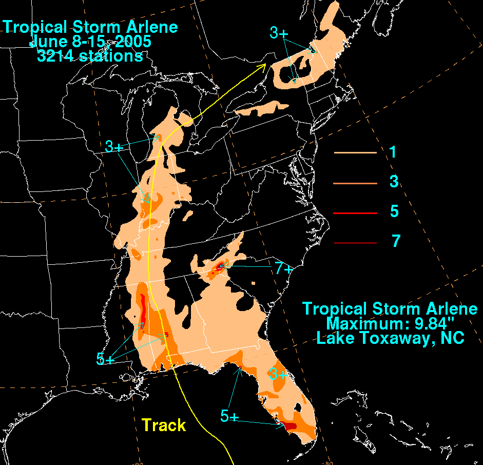
, the storm dropped heavy rainfall, peaking at 8.51 inches (216 mm) in Plantation Bay, Florida in Flagler County
Flagler County, Florida
Flagler County was created in 1917 from portions of Saint Johns and Volusia counties. It was named for Henry Morrison Flagler, a famous railroad builder who built the Florida East Coast Railway. Bunnell is the county seat of Flagler County....
. Upon making landfall, Arlene caused a storm surge of up to 5 feet (1.5 m) in Walton County
Walton County, Florida
Walton County is a county located in the state of Florida. As of 2000, the population was 40,601. The U.S. Census Bureau 2005 estimate for the county is 50,324. Its county seat is DeFuniak Springs, Florida. The county is home to the highest natural point in Florida: Britton Hill, at .- History...
. Moderate beach erosion also occurred. The storm surge and strong waves caused moderate to severe damage to roads along the panhandle. Strong winds caused power outages to 500 people in Walton, Washington
Washington County, Florida
Washington County is a county located in the state of Florida. As of 2000, the population was 20,973. The U.S. Census Bureau 2005 estimate for the county was 22,299. Its county seat is Chipley, Florida...
and Bay
Bay County, Florida
Bay County is a county located in the U.S. state of Florida. The U.S. Census Bureau 2006 estimate for the county is 163,505 . Its county seat is Panama City, Florida. The county is best known for its white sand beaches and crystal blue water, where large pods of dolphins swim year-round...
counties. The storm spawned a weak tornado
Tornado
A tornado is a violent, dangerous, rotating column of air that is in contact with both the surface of the earth and a cumulonimbus cloud or, in rare cases, the base of a cumulus cloud. They are often referred to as a twister or a cyclone, although the word cyclone is used in meteorology in a wider...
in Navarre, Florida
Navarre, Florida
Navarre is an unincorporated community in Santa Rosa County in the Northwest Florida Panhandle. Navarre is about 25 miles east of Pensacola and about 15 miles west of Fort Walton Beach. The community is roughly centered on the junction of U.S. Route 98 and State Road 87...
, causing minor damage on its 0.1-mile (0.2-km) path. Damage on the panhandle totaled to $3.5 million (2005 USD), $2.5 million of which was in Fort Pickens
Fort Pickens
Fort Pickens is a pentagonal historic United States military fort on Santa Rosa Island in the Pensacola, Florida, area. It is named after American Revolutionary War hero Andrew Pickens. The fort was completed in 1834 and remained in use until 1947...
alone.
Alabama
Upon making landfall, the storm produced storm tides of up to 3.9 feet (1.2 m) in height. Minor beach erosion occurred as well. Arlene dropped moderate to heavy rainfall throughout AlabamaAlabama
Alabama is a state located in the southeastern region of the United States. It is bordered by Tennessee to the north, Georgia to the east, Florida and the Gulf of Mexico to the south, and Mississippi to the west. Alabama ranks 30th in total land area and ranks second in the size of its inland...
, with higher totals of up to eight inches (200 mm) to the west of Interstate 65
Interstate 65
Interstate 65 is a major Interstate Highway in the United States. The southern terminus is located at an intersection with Interstate 10 in Mobile, Alabama, and its northern terminus is at an interchange with Interstate 90 , U.S. Route 12, and U.S...
. Four to six inches (152 mm) of rain fell in a three hour period in the Mobile
Mobile, Alabama
Mobile is the third most populous city in the Southern US state of Alabama and is the county seat of Mobile County. It is located on the Mobile River and the central Gulf Coast of the United States. The population within the city limits was 195,111 during the 2010 census. It is the largest...
area. Several roads were temporarily impassable from the flooding, and one road was completely washed away. Wind speeds were around 20 to 30 mph (30 to 50 km/h), while wind gusts of over 60 mph (95 km/h) existed. The winds downed several trees and power lines, leaving thousands without power for several hours. With the storm following a path similar to Hurricane Ivan
Hurricane Ivan
Hurricane Ivan was a large, long-lived, Cape Verde-type hurricane that caused widespread damage in the Caribbean and United States. The cyclone was the ninth named storm, the sixth hurricane and the fourth major hurricane of the active 2004 Atlantic hurricane season...
just nine months earlier, many trees damaged from Ivan were downed completely. In addition, several homes experienced light wind damage. The outer bands of the storm also caused numerous funnel clouds, though no tornadoes were reported. Overall, damage was light, amounting to $1.7 million (2005 USD).
Elsewhere
Heavy rainfall in Towns County, GeorgiaTowns County, Georgia
Towns County is a county located in the U.S. state of Georgia. It was created on March 6, 1856. As of the 2000 census, the population was 9,319. The 2007 Census Estimate shows a population of 10,894. Its county seat is Hiawassee.-History:...
forced multiple residents to evacuate from rising flood water. Numerous creeks and rivers in the northern portion of the state overflowed.
Tropical Storm Arlene caused light rainfall across southeastern Mississippi
Mississippi
Mississippi is a U.S. state located in the Southern United States. Jackson is the state capital and largest city. The name of the state derives from the Mississippi River, which flows along its western boundary, whose name comes from the Ojibwe word misi-ziibi...
, typically between 1 to 2 inches (25 to 50 mm). Effects were generally minimal.
In Indiana
Indiana
Indiana is a US state, admitted to the United States as the 19th on December 11, 1816. It is located in the Midwestern United States and Great Lakes Region. With 6,483,802 residents, the state is ranked 15th in population and 16th in population density. Indiana is ranked 38th in land area and is...
, the remnants of Arlene dropped heavy rainfall, peaking at 4.44 inches (112.8 mm) in Evansville
Evansville, Indiana
Evansville is the third-largest city in the U.S. state of Indiana and the largest city in Southern Indiana. As of the 2010 census, the city had a total population of 117,429. It is the county seat of Vanderburgh County and the regional hub for both Southwestern Indiana and the...
. In Indianapolis
Indianapolis
Indianapolis is the capital of the U.S. state of Indiana, and the county seat of Marion County, Indiana. As of the 2010 United States Census, the city's population is 839,489. It is by far Indiana's largest city and, as of the 2010 U.S...
, 3.04 inches (75 mm) fell at the International Airport
Indianapolis International Airport
Indianapolis International Airport is a public airport located seven miles southwest of the central business district of Indianapolis, a city in Marion County, Indiana, United States. It is owned and operated by the Indianapolis Airport Authority...
. Rainfall from the storm was 85% of the typical June rainfall level. Arlene also spawned two tornadoes. An F1
Fujita scale
The Fujita scale , or Fujita-Pearson scale, is a scale for rating tornado intensity, based primarily on the damage tornadoes inflict on human-built structures and vegetation...
tornado developed to the southwest of Hayden
Hayden, Indiana
Hayden is an unincorporated community in central Spencer Township, Jennings County, Indiana, United States. It lies along CR700W west of the town of Vernon, the county seat of Jennings County. Its elevation is 620 feet , and it is located at...
on June 12. The tornado damaged several buildings and trees on its 5.3-mile (8.5-km) path, with total damage amounting to $100,000 (2005 USD). Outer rainbands also developed an F0 tornado just south of Indianapolis
Indianapolis
Indianapolis is the capital of the U.S. state of Indiana, and the county seat of Marion County, Indiana. As of the 2010 United States Census, the city's population is 839,489. It is by far Indiana's largest city and, as of the 2010 U.S...
, downing a few tree limbs.
The remnants of Arlene combined with a non-tropical system caused heavy rainfall across New York
New York
New York is a state in the Northeastern region of the United States. It is the nation's third most populous state. New York is bordered by New Jersey and Pennsylvania to the south, and by Connecticut, Massachusetts and Vermont to the east...
, with some locations reporting 6 to 7 inches (150 to 175 mm) of precipitation in a 2-hour period. The rainfall collected into streams and rivers, with some officials calling it a 1 in 500 year flood. The flash flooding caused at least one mudslide, and damaged several roads. The flooding forced at least 20 to evacuate from their homes, and numerous houses were damaged. Strong winds also downed trees and power lines, causing scattered power outages. Damage totaled to $6.5 million (2005 USD).
See also
- List of Florida hurricanes (2000–present)
- Other storms of the same nameHurricane ArleneThe name Arlene has been used for ten tropical cyclones in the Atlantic Ocean, making Arlene the most frequently used Atlantic storm name.* Tropical Storm Arlene , a tropical storm which brought flooding to Louisiana, killing one person...
External links
- NHC's archive on Tropical Storm Arlene.
- The Hydrometeorological Prediction CenterHydrometeorological Prediction CenterThe Hydrometeorological Prediction Center is one of nine service centers under the umbrella of the National Centers for Environmental Prediction , a part of the National Weather Service, which in turn is part of the National Oceanic and Atmospheric Administration of the U.S. government...
's (HPC) archive on Tropical Storm Arlene. - NHC's Tropical Cyclone Report on Tropical Storm Arlene