
Hurricane Connie
Encyclopedia
Hurricane Connie was the first in a series of hurricanes to strike North Carolina
during the 1955 Atlantic hurricane season
. Connie struck as a Category 1, causing major flooding and inflicting extensive damage to the Outer Banks
and inland to Raleigh
.
developed into a tropical cyclone
on August 3 to the west of the Cape Verde
islands, based on reports from two ships. It moved rapidly to the west-northwest, quickly intensifying into Tropical Storm Connie. A Hurricane Hunters
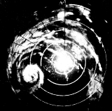
flight on August 4 reported a developing eye feature
, and the next day Connie rapidly strengthened into a 125 mph (201.2 km/h) major hurricane
. On August 6, it passed about 60 mi (96.6 km) north of the Lesser Antilles
and Puerto Rico
. By that time, Connie had attained peak winds of 145 mph (233.4 km/h), or the equivalence of a current-day Category 4 on the Saffir-Simpson scale
.
For four days, Connie maintained its peak intensity as its track shifted from the west-northwest toward the northwest, passing to the northeast of the Bahamas as it rounded a large ridge
. On August 7, its eye had decreased to a diameter of 7 mi (11.3 km). By August 10, the eye had lost its definition as Connie slowed its northwest track. It began a west-northwest drift due to slight interaction
with developing Hurricane Diane
to its southeast, as well as a building ridge to its northeast. The hurricane turned to the north on August 11 and was steadily weakening, due to the combination of upwelling
and entrainment of cool air. Connie turned toward the north-northeast on August 12, by which time it had weakened to a minimal hurricane. Late that day, it moved ashore near Fort Macon State Park
in North Carolina. According to the Atlantic hurricane database
, Connie made landfall with winds of 80 mph (128.7 km/h), although the Hurricane Research Division
suggested that the hurricane hit North Carolina with winds of at least 115 mph (185.1 km/h). It progressed inland, weakening to a tropical storm over Virginia and moving northward through the Chesapeake Bay
. Connie turned to the northwest, passing through much of Pennsylvania before weakening to a tropical depression near the Pennsylvania/New York border. After crossing Lake Ontario
and southwestern Ontario, the system moved through Lake Huron
, dissipating on August 15 near Sault Ste. Marie, Michigan
.
 On August 5, Hurricane Connie began to become an apparent threat to the northeastern Caribbean Islands, with maximum winds in the storm reaching 125 mph (205 km/h). The National Weather Bureau issued hurricane warnings for Barbuda
, Saba and Antigua
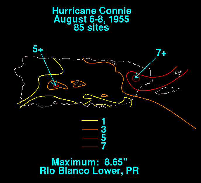
. The Virgin Islands and Puerto Rico were placed on hurricane alert as warnings were possible later that day. Early in its duration, the outer rainbands of Connie produced wind gusts 100 mph (160 km/h) in Lesser Antilles and Puerto Rico, along with heavy rainfall. The highest precipitation total was 8.65 in (219.7 mm) along the lower Río Blanco.
 As Connie moved ashore in North Carolina, it produced sustained winds of 72 mph (115.9 km/h) in Morehead City
, with gusts to 83 mph (133.6 km/h). Wind gusts near where the hurricane moved ashore reached 100 mph (160 km/h), although it was not confirmed whether the gust was estimated or measured. Along Connie's western periphery, the rainbands spawned at least six tornadoes, of which five in South Carolina and one in North Carolina. Moving slowly ashore, the hurricane produced tides that were up to 8 ft (2.4 m) above normal, which resulted in significant beach erosion. Rainfall amounts of over 10 in (254 mm) in the area west of where Connie made landfall. Throughout the state, the hurricane caused about $40 million in damage, of which about 75% was from crop damage.
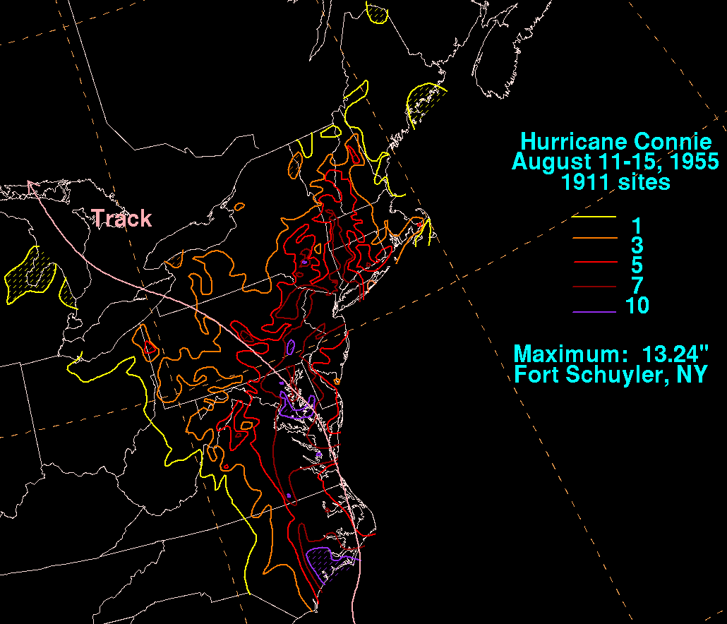
Hurricane force winds extended into Virginia. As Connie progressed northward, it continued to drop significant amounts of precipitation. Totals of over 10 in (254 mm) were reported on both sides of the Chesapeake Bay, in Pennsylvania, and in southeastern New York. The highest precipitation related to Connie was 13.24 in (336.3 mm) at Fort Schuyler. Rainfall also extended as far west as Michigan and as far east as Maine. Across the northeastern United States, high rainfall from the hurricane resulted in disastrous flooding, along with Diane which moved ashore four days after Connie; this was due to unusually moist air across the region, which resulted from above average water and air temperatures. Many areas were in drought conditions before the flooding.
In Washington D.C., a car accident caused by slick roads resulted in the death of four people after a car was sideswiped and knocked into a swollen creek where the occupants drowned.
Hurricane Connie brought the heaviest rain seen in New York in over 50 years during its passage, dropping 5.32 in (135.1 mm) in New York City
within a 20 hour span. Large areas of the city, including subways, were flooded and many residents were left without power. At least seven people were killed in various incidents across the state.
North Carolina
North Carolina is a state located in the southeastern United States. The state borders South Carolina and Georgia to the south, Tennessee to the west and Virginia to the north. North Carolina contains 100 counties. Its capital is Raleigh, and its largest city is Charlotte...
during the 1955 Atlantic hurricane season
1955 Atlantic hurricane season
The 1955 Atlantic hurricane season officially began on June 15, 1955, and lasted until November 15, 1955. These dates conventionally delimit the period of each year when most tropical cyclones form in the Atlantic basin. The 1955 season was active, with twelve tropical storms forming.Three...
. Connie struck as a Category 1, causing major flooding and inflicting extensive damage to the Outer Banks
Outer Banks
The Outer Banks is a 200-mile long string of narrow barrier islands off the coast of North Carolina, beginning in the southeastern corner of Virginia Beach on the east coast of the United States....
and inland to Raleigh
Raleigh, North Carolina
Raleigh is the capital and the second largest city in the state of North Carolina as well as the seat of Wake County. Raleigh is known as the "City of Oaks" for its many oak trees. According to the U.S. Census Bureau, the city's 2010 population was 403,892, over an area of , making Raleigh...
.
Meteorological history
A tropical waveTropical wave
Tropical waves, easterly waves, or tropical easterly waves, also known as African easterly waves in the Atlantic region, are a type of atmospheric trough, an elongated area of relatively low air pressure, oriented north to south, which move from east to west across the tropics causing areas of...
developed into a tropical cyclone
Tropical cyclone
A tropical cyclone is a storm system characterized by a large low-pressure center and numerous thunderstorms that produce strong winds and heavy rain. Tropical cyclones strengthen when water evaporated from the ocean is released as the saturated air rises, resulting in condensation of water vapor...
on August 3 to the west of the Cape Verde
Cape Verde
The Republic of Cape Verde is an island country, spanning an archipelago of 10 islands located in the central Atlantic Ocean, 570 kilometres off the coast of Western Africa...
islands, based on reports from two ships. It moved rapidly to the west-northwest, quickly intensifying into Tropical Storm Connie. A Hurricane Hunters
Hurricane Hunters
The Hurricane Hunters are aircraft that fly into tropical cyclones in the North Atlantic Ocean and Northeastern Pacific Ocean for the specific purpose of directly measuring weather data in and around those storms. In the United States, the Air Force, Navy, and NOAA units have all participated in...
flight on August 4 reported a developing eye feature
Eye (cyclone)
The eye is a region of mostly calm weather found at the center of strong tropical cyclones. The eye of a storm is a roughly circular area and typically 30–65 km in diameter. It is surrounded by the eyewall, a ring of towering thunderstorms where the second most severe weather of a cyclone...
, and the next day Connie rapidly strengthened into a 125 mph (201.2 km/h) major hurricane
Tropical cyclone scales
Tropical systems are officially ranked on one of several tropical cyclone scales according to their maximum sustained winds and in what oceanic basin they are located...
. On August 6, it passed about 60 mi (96.6 km) north of the Lesser Antilles
Lesser Antilles
The Lesser Antilles are a long, partly volcanic island arc in the Western Hemisphere. Most of its islands form the eastern boundary of the Caribbean Sea with the Atlantic Ocean, with the remainder located in the southern Caribbean just north of South America...
and Puerto Rico
Puerto Rico
Puerto Rico , officially the Commonwealth of Puerto Rico , is an unincorporated territory of the United States, located in the northeastern Caribbean, east of the Dominican Republic and west of both the United States Virgin Islands and the British Virgin Islands.Puerto Rico comprises an...
. By that time, Connie had attained peak winds of 145 mph (233.4 km/h), or the equivalence of a current-day Category 4 on the Saffir-Simpson scale
Saffir-Simpson Hurricane Scale
The Saffir–Simpson Hurricane Scale , or the Saffir–Simpson Hurricane Wind Scale , classifies hurricanes — Western Hemisphere tropical cyclones that exceed the intensities of tropical depressions and tropical storms — into five categories distinguished by the intensities of their sustained winds...
.
For four days, Connie maintained its peak intensity as its track shifted from the west-northwest toward the northwest, passing to the northeast of the Bahamas as it rounded a large ridge
Ridge (meteorology)
A ridge is an elongated region of relatively high atmospheric pressure, the opposite of a trough....
. On August 7, its eye had decreased to a diameter of 7 mi (11.3 km). By August 10, the eye had lost its definition as Connie slowed its northwest track. It began a west-northwest drift due to slight interaction
Fujiwhara effect
The Fujiwhara effect or Fujiwara interaction, named after Sakuhei Fujiwhara, is a type of interaction between two nearby cyclonic vortices, causing them to appear to "orbit" each other.-Description:...
with developing Hurricane Diane
Hurricane Diane
Hurricane Diane was one of three hurricanes to hit North Carolina during the 1955 Atlantic hurricane season, striking an area that had been hit by Hurricane Connie five days earlier...
to its southeast, as well as a building ridge to its northeast. The hurricane turned to the north on August 11 and was steadily weakening, due to the combination of upwelling
Upwelling
Upwelling is an oceanographic phenomenon that involves wind-driven motion of dense, cooler, and usually nutrient-rich water towards the ocean surface, replacing the warmer, usually nutrient-depleted surface water. The increased availability in upwelling regions results in high levels of primary...
and entrainment of cool air. Connie turned toward the north-northeast on August 12, by which time it had weakened to a minimal hurricane. Late that day, it moved ashore near Fort Macon State Park
Fort Macon State Park
Fort Macon State Park is a North Carolina state park in Carteret County, North Carolina, in the United States. Located on Bogue Banks near Atlantic Beach, the park opened in 1936...
in North Carolina. According to the Atlantic hurricane database
HURDAT
The North Atlantic hurricane database, or HURDAT, is the database for all tropical cyclones in the Atlantic Ocean, Gulf of Mexico and Caribbean Sea, since 1851.-History:...
, Connie made landfall with winds of 80 mph (128.7 km/h), although the Hurricane Research Division
Hurricane Research Division
The Hurricane Research Division is a section of the Atlantic Oceanographic and Meteorological Laboratory in Miami, Florida, and is the National Oceanic and Atmospheric Administration's focus for tropical cyclone research...
suggested that the hurricane hit North Carolina with winds of at least 115 mph (185.1 km/h). It progressed inland, weakening to a tropical storm over Virginia and moving northward through the Chesapeake Bay
Chesapeake Bay
The Chesapeake Bay is the largest estuary in the United States. It lies off the Atlantic Ocean, surrounded by Maryland and Virginia. The Chesapeake Bay's drainage basin covers in the District of Columbia and parts of six states: New York, Pennsylvania, Delaware, Maryland, Virginia, and West...
. Connie turned to the northwest, passing through much of Pennsylvania before weakening to a tropical depression near the Pennsylvania/New York border. After crossing Lake Ontario
Lake Ontario
Lake Ontario is one of the five Great Lakes of North America. It is bounded on the north and southwest by the Canadian province of Ontario, and on the south by the American state of New York. Ontario, Canada's most populous province, was named for the lake. In the Wyandot language, ontarío means...
and southwestern Ontario, the system moved through Lake Huron
Lake Huron
Lake Huron is one of the five Great Lakes of North America. Hydrologically, it comprises the larger portion of Lake Michigan-Huron. It is bounded on the east by the Canadian province of Ontario and on the west by the state of Michigan in the United States...
, dissipating on August 15 near Sault Ste. Marie, Michigan
Sault Ste. Marie, Michigan
Sault Ste. Marie is a city in and the county seat of Chippewa County in the U.S. state of Michigan. It is in the north-eastern end of Michigan's Upper Peninsula, on the Canadian border, separated from its twin city of Sault Ste. Marie, Ontario, by the St. Marys River...
.
Impact
Barbuda
Barbuda is an island in the Eastern Caribbean, and forms part of the state of Antigua and Barbuda. It has a population of about 1,500, most of whom live in the town of Codrington.-Location:...
, Saba and Antigua
Antigua
Antigua , also known as Waladli, is an island in the West Indies, in the Leeward Islands in the Caribbean region, the main island of the country of Antigua and Barbuda. Antigua means "ancient" in Spanish and was named by Christopher Columbus after an icon in Seville Cathedral, Santa Maria de la...
. The Virgin Islands and Puerto Rico were placed on hurricane alert as warnings were possible later that day. Early in its duration, the outer rainbands of Connie produced wind gusts 100 mph (160 km/h) in Lesser Antilles and Puerto Rico, along with heavy rainfall. The highest precipitation total was 8.65 in (219.7 mm) along the lower Río Blanco.
Morehead City, North Carolina
Morehead City is a port city in Carteret County, North Carolina, United States. The population was 8,661 at the 2010 census. Morehead City celebrated the 150th anniversary of its founding on May 5, 2007...
, with gusts to 83 mph (133.6 km/h). Wind gusts near where the hurricane moved ashore reached 100 mph (160 km/h), although it was not confirmed whether the gust was estimated or measured. Along Connie's western periphery, the rainbands spawned at least six tornadoes, of which five in South Carolina and one in North Carolina. Moving slowly ashore, the hurricane produced tides that were up to 8 ft (2.4 m) above normal, which resulted in significant beach erosion. Rainfall amounts of over 10 in (254 mm) in the area west of where Connie made landfall. Throughout the state, the hurricane caused about $40 million in damage, of which about 75% was from crop damage.
Hurricane force winds extended into Virginia. As Connie progressed northward, it continued to drop significant amounts of precipitation. Totals of over 10 in (254 mm) were reported on both sides of the Chesapeake Bay, in Pennsylvania, and in southeastern New York. The highest precipitation related to Connie was 13.24 in (336.3 mm) at Fort Schuyler. Rainfall also extended as far west as Michigan and as far east as Maine. Across the northeastern United States, high rainfall from the hurricane resulted in disastrous flooding, along with Diane which moved ashore four days after Connie; this was due to unusually moist air across the region, which resulted from above average water and air temperatures. Many areas were in drought conditions before the flooding.
In Washington D.C., a car accident caused by slick roads resulted in the death of four people after a car was sideswiped and knocked into a swollen creek where the occupants drowned.
Hurricane Connie brought the heaviest rain seen in New York in over 50 years during its passage, dropping 5.32 in (135.1 mm) in New York City
New York City
New York is the most populous city in the United States and the center of the New York Metropolitan Area, one of the most populous metropolitan areas in the world. New York exerts a significant impact upon global commerce, finance, media, art, fashion, research, technology, education, and...
within a 20 hour span. Large areas of the city, including subways, were flooded and many residents were left without power. At least seven people were killed in various incidents across the state.
Aftermath
Due to its destructive impacts, the name Connie was retired, and will never again be used for an Atlantic hurricane.See also
- List of Atlantic hurricanes
- List of retired Atlantic hurricane names
- List of wettest tropical cyclones in Massachusetts
- List of North Carolina hurricanes