

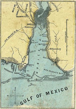
Mobile Bay
Encyclopedia
Mobile Bay is an inlet of the Gulf of Mexico
, lying within the state of Alabama
in the United States
. Its mouth is formed by the Fort Morgan
Peninsula on the eastern side and Dauphin Island, a barrier island
on the western side. The Mobile River
and Tensaw River
empty into the northern end of the bay, making it an estuary
. Several smaller rivers also empty into the bay: Dog River
, Deer River, and Fowl River
on the western side of the bay, and Fish River
on the eastern side. Mobile Bay is the fourth largest estuary in the United States with a discharge of 62000 cubic feet (1,755.6 m³) of water per second.
Mobile Bay is 413 square miles (1,069.7 km²) in area. It is 31 miles (50 km) long by a maximum width of 24 miles (39 km). The deepest areas of the bay are located within the shipping channel, sometimes in excess of 75 feet (23 m) deep, but the average depth of the bay is 10 feet (3 m).
. In 1528, Pánfilo de Narváez
travelled through what was likely the Mobile Bay area, encountering Native American
s who fled and burned their towns at the approach of the expedition. This response was a prelude to the journeys of Hernando de Soto
, more than eleven years later.
 Hernando de Soto explored the area of Mobile Bay and beyond in 1540, finding the area inhabited by a Muskhogean
Native American
people. During this expedition his forces destroyed the fortified town of Mauvila, also spelled Maubila, from which the name Mobile was later derived. This battle with Chief Tuscaloosa
and his warriors took place somewhere in inland Alabama, well to the north of the current site of Mobile. The next large expedition was that of Tristán de Luna y Arellano
, in his unsuccessful attempt to establish a permanent colony for Spain nearby at Pensacola
in 1559.
Although Spain's presence in the area had been sporadic, the French
created a deep-sea port at Dauphin Island and founded French Louisiana
's capital at Mobile, a few miles north of Mobile Bay on the Mobile River
in 1702. The original settlement of Fort Louis de la Mobile was relocated in 1711 to the head of Mobile Bay following a series of floods.
On August 5, 1864, during the American Civil War
, Admiral David Farragut
led a Union
flotilla through Confederate
defenses and sealed one of the last major Southern ports of the bay in the Battle of Mobile Bay
. A number of Civil War-era shipwrecks remain in Mobile Bay, including American Diver
, CSS Gaines
, CSS Huntsville
, USS Philippi
, CSS Phoenix
, USS Rodolph
, USS Tecumseh
, and CSS Tuscaloosa
.
Mobile's role as a seaport has continued to the present day, though the commodities have changed through time. Cotton
was the chief commodity in the nineteenth century. During the Second World War, Mobile's shipbuilding industry expanded and the city's population surged. Growth has been rapid since then.
The city has endured several devastating hurricanes in its history, the most recent being Hurricane Frederic
in 1979 and Hurricane Katrina
in 2005. Areas of low elevation, including the downtown business district, have been flooded repeatedly in hurricanes. However, much of the city is at an elevation exceeding 200 feet (61 m) above sea level, which is unusually high for the Gulf and Atlantic Coasts.
On September 13, 1979, Hurricane Frederic
entered the bay with winds reaching 145 miles per hour (64.8 m/s), destroying the bridge to Dauphin Island. On August 28–29, 2005, Hurricane Katrina
pushed a massive storm surge into Mobile Bay, measuring 16 feet (4.9 m) high at Bayou La Batre (Alabama), with higher waves on top, and 12 feet (3.7 m) high at Mobile, at the far northern end of Mobile Bay. Thousands of boats, piers, and beach houses were damaged by waves exceeding 22 feet (6.7 m) high, and the battleship
USS Alabama
was pushed off her moorings, leaving her listing to port (tilted to the left). Downtown Mobile was flooded several feet, and the south-end towns of Bayou La Batre and Bon Secour
were severely damaged. Dozens of vessels of various sizes were left stranded inland.
is situated at the head of the bay on the western shore. On the Eastern Shore
of the bay are found several small communities, including Spanish Fort
, Daphne
, Fairhope
, Point Clear
, and Bon Secour
. The town of Gulf Shores
lies just outside of the bay, on the Fort Morgan peninsula. The Middle Bay Lighthouse has been located in the center of the bay since 1885.
The head of the bay is crossed by two major thoroughfares, the Jubilee Parkway
, better known as the "Bayway", and the Battleship Parkway
, better known as the "Causeway". These two bridges serve as the primary connections between the city of Mobile and the Eastern Shore. On warm summer nights, the residents living around Mobile Bay sometimes enjoy the fruits of a mysterious natural phenomenon called a Jubilee
, when fish and crabs swarm toward shore and can be easily harvested by people wading in the shallows.
Gulf of Mexico
The Gulf of Mexico is a partially landlocked ocean basin largely surrounded by the North American continent and the island of Cuba. It is bounded on the northeast, north and northwest by the Gulf Coast of the United States, on the southwest and south by Mexico, and on the southeast by Cuba. In...
, lying within the state of Alabama
Alabama
Alabama is a state located in the southeastern region of the United States. It is bordered by Tennessee to the north, Georgia to the east, Florida and the Gulf of Mexico to the south, and Mississippi to the west. Alabama ranks 30th in total land area and ranks second in the size of its inland...
in the United States
United States
The United States of America is a federal constitutional republic comprising fifty states and a federal district...
. Its mouth is formed by the Fort Morgan
Fort Morgan
Fort Morgan can apply to any one of several places in the United States:*Fort Morgan , a fort at the mouth of Mobile Bay*Fort Morgan, Alabama, a nearby community...
Peninsula on the eastern side and Dauphin Island, a barrier island
Barrier island
Barrier islands, a coastal landform and a type of barrier system, are relatively narrow strips of sand that parallel the mainland coast. They usually occur in chains, consisting of anything from a few islands to more than a dozen...
on the western side. The Mobile River
Mobile River
The Mobile River is located in southern Alabama in the United States. Formed out of the confluence of the Tombigbee and Alabama rivers, the approximately river drains an area of of Alabama, with a watershed extending into Mississippi, Georgia, and Tennessee. Its drainage basin is the...
and Tensaw River
Tensaw River
The Tensaw River is a distributary of the Mobile River, approximately 36 mi long, in southern Alabama in the United States. It is formed as a bayou of the Mobile approximately 6 mi south of the formation of the Mobile by the confluence of the Tombigbee and Alabama rivers...
empty into the northern end of the bay, making it an estuary
Estuary
An estuary is a partly enclosed coastal body of water with one or more rivers or streams flowing into it, and with a free connection to the open sea....
. Several smaller rivers also empty into the bay: Dog River
Dog River (Alabama)
The Dog River is a river in Mobile County, Alabama. The Dog River watershed drains more than . The river is about long and is influenced by tides. It originates at within the city of Mobile. It discharges into Mobile Bay, a tidal estuary on the northern Gulf of Mexico, at near Hollinger's Island...
, Deer River, and Fowl River
Fowl River
Fowl River is a brackish river in Mobile County, Alabama. It originates near Theodore and then splits into the East Fowl River and the West Fowl River. The East Fowl River discharges into Mobile Bay south of Belle Fontaine. The West Fowl River discharges into the Mississippi Sound east of Coden...
on the western side of the bay, and Fish River
Fish River (Alabama)
Fish River is a river in Baldwin County, Alabama. It originates at , near Stapleton, and discharges into Weeks Bay at in Magnolia Springs. It was named by the original French colonists as the Riviere Aux Poissons, which can be translated into English as Fish River....
on the eastern side. Mobile Bay is the fourth largest estuary in the United States with a discharge of 62000 cubic feet (1,755.6 m³) of water per second.
Mobile Bay is 413 square miles (1,069.7 km²) in area. It is 31 miles (50 km) long by a maximum width of 24 miles (39 km). The deepest areas of the bay are located within the shipping channel, sometimes in excess of 75 feet (23 m) deep, but the average depth of the bay is 10 feet (3 m).
History
Spanish explorers were sailing into the area of Mobile Bay as early as 1500, with the bay being marked on early maps as the Bahía del Espíritu Santo (Bay of the Holy Spirit). The area was explored in more detail in 1516 by Diego de Miruelo and in 1519 by Alonso Álvarez de PinedaAlonso Álvarez de Pineda
Alonso Álvarez de Pineda was a Spanish explorer and cartographer. His map marks the first document in Texas history.-Expedition:The Spanish thought there must be a sea lane from the Gulf of Mexico to Asia...
. In 1528, Pánfilo de Narváez
Pánfilo de Narváez
Pánfilo de Narváez was a Spanish conqueror and soldier in the Americas. He is most remembered as the leader of two expeditions, one to Mexico in 1520 to oppose Hernán Cortés, and the disastrous Narváez expedition to Florida in 1527....
travelled through what was likely the Mobile Bay area, encountering Native American
Native Americans in the United States
Native Americans in the United States are the indigenous peoples in North America within the boundaries of the present-day continental United States, parts of Alaska, and the island state of Hawaii. They are composed of numerous, distinct tribes, states, and ethnic groups, many of which survive as...
s who fled and burned their towns at the approach of the expedition. This response was a prelude to the journeys of Hernando de Soto
Hernando de Soto (explorer)
Hernando de Soto was a Spanish explorer and conquistador who, while leading the first European expedition deep into the territory of the modern-day United States, was the first European documented to have crossed the Mississippi River....
, more than eleven years later.
Muskhogean stock
Muskhogean stock refers to a Native American stock that inhabited the Gulf Coast region of what is today the United States. The name derives from the chief tribe in the Creek confederacy, the Muskogee, but consisted of the Creeks, Choctaws, Chickasaws, Seminoles, and other tribes...
Native American
Native Americans in the United States
Native Americans in the United States are the indigenous peoples in North America within the boundaries of the present-day continental United States, parts of Alaska, and the island state of Hawaii. They are composed of numerous, distinct tribes, states, and ethnic groups, many of which survive as...
people. During this expedition his forces destroyed the fortified town of Mauvila, also spelled Maubila, from which the name Mobile was later derived. This battle with Chief Tuscaloosa
Chief Tuscaloosa
Tuskaloosa was a paramount chief of a Mississippian chiefdom in what is now the U.S. state of Alabama. His people were possibly ancestors to the several southern Native American confederacies who later emerged in the region...
and his warriors took place somewhere in inland Alabama, well to the north of the current site of Mobile. The next large expedition was that of Tristán de Luna y Arellano
Tristán de Luna y Arellano
Tristán de Luna y Arellano was a Spanish Conquistador of the 16th century. Born in Borobia, Spain, he came to New Spain in about 1530, and was sent on an expedition to conquer Florida in 1559...
, in his unsuccessful attempt to establish a permanent colony for Spain nearby at Pensacola
Pensacola
Pensacola is a city in the western part of the U.S. state of Florida.Pensacola may also refer to:* Pensacola people, a group of Native Americans* A number of places in the Florida:** Pensacola Bay** Pensacola Regional Airport...
in 1559.
Although Spain's presence in the area had been sporadic, the French
France
The French Republic , The French Republic , The French Republic , (commonly known as France , is a unitary semi-presidential republic in Western Europe with several overseas territories and islands located on other continents and in the Indian, Pacific, and Atlantic oceans. Metropolitan France...
created a deep-sea port at Dauphin Island and founded French Louisiana
Louisiana (New France)
Louisiana or French Louisiana was an administrative district of New France. Under French control from 1682–1763 and 1800–03, the area was named in honor of Louis XIV, by French explorer René-Robert Cavelier, Sieur de la Salle...
's capital at Mobile, a few miles north of Mobile Bay on the Mobile River
Mobile River
The Mobile River is located in southern Alabama in the United States. Formed out of the confluence of the Tombigbee and Alabama rivers, the approximately river drains an area of of Alabama, with a watershed extending into Mississippi, Georgia, and Tennessee. Its drainage basin is the...
in 1702. The original settlement of Fort Louis de la Mobile was relocated in 1711 to the head of Mobile Bay following a series of floods.
On August 5, 1864, during the American Civil War
American Civil War
The American Civil War was a civil war fought in the United States of America. In response to the election of Abraham Lincoln as President of the United States, 11 southern slave states declared their secession from the United States and formed the Confederate States of America ; the other 25...
, Admiral David Farragut
David Farragut
David Glasgow Farragut was a flag officer of the United States Navy during the American Civil War. He was the first rear admiral, vice admiral, and admiral in the United States Navy. He is remembered in popular culture for his order at the Battle of Mobile Bay, usually paraphrased: "Damn the...
led a Union
United States
The United States of America is a federal constitutional republic comprising fifty states and a federal district...
flotilla through Confederate
Confederate States of America
The Confederate States of America was a government set up from 1861 to 1865 by 11 Southern slave states of the United States of America that had declared their secession from the U.S...
defenses and sealed one of the last major Southern ports of the bay in the Battle of Mobile Bay
Battle of Mobile Bay
The Battle of Mobile Bay of August 5, 1864, was an engagement of the American Civil War in which a Federal fleet commanded by Rear Adm. David G. Farragut, assisted by a contingent of soldiers, attacked a smaller Confederate fleet led by Adm...
. A number of Civil War-era shipwrecks remain in Mobile Bay, including American Diver
American Diver
American Diver, also known as the Pioneer II, was a prototype submarine built for the Confederate States of America military. It was the first successor to the Pioneer. The Diver was invented and built by the same consortium that built the Pioneer in New Orleans. It was composed of Horace Lawson...
, CSS Gaines
CSS Gaines
CSS Gaines was a wooden side wheel gunboat constructed by the Confederates at Mobile, Alabama during 1861-62. The ship was hastily built with unseasoned wood, which was partially covered with 2-inch iron plating. Gaines resembled CSS Morgan except that she had high pressure boilers. Operating in...
, CSS Huntsville
CSS Huntsville
CSS Huntsville was a Confederate ironclad floating battery built at Selma, Alabama from 1862 to 1863.-Huntsville:Huntsville was ordered on May 1, 1862 by the Confederate States Navy. She was launched at the Confederate Naval Works at Selma on February 7, 1863 and finished in Mobile. She was...
, USS Philippi
USS Philippi (1863)
USS Philippi was a blockade runner captured by the Union Navy during the American Civil War. She served the Union Navy’s struggle against the Confederate States of America as a picket, patrol and dispatch vessel....
, CSS Phoenix
CSS Phoenix
CSS Phoenix was a Confederate ironclad floating battery built at Selma, Alabama from 1863–64.-Huntsville:Phoenix was built at the Confederate Naval Works at Selma in 1863 and launched in March 1864. She was severely damaged during the launching and subsequently could not be used as a warship...
, USS Rodolph
USS Rodolph (1863)
USS Rodolph was a steamer commissioned by the Union Navy during the American Civil War.She served the Union Navy during her struggle against the Confederate States of America both as a tugboat and a minesweeper, as well as a gunboat when the occasion demanded.Unfortunately for Rodolph, just as the...
, USS Tecumseh
USS Tecumseh (1863)
The first USS Tecumseh was an iron-hulled, single-turret monitor in the United States Navy during the American Civil War.Tecumseh was launched on 12 September 1863 at Jersey City, New Jersey, by Secor and Company,of New York City; and was commissioned at the New York Navy Yard on 19 April 1864,...
, and CSS Tuscaloosa
CSS Tuscaloosa (ironclad)
CSS Tuscaloosa was a screw ironclad steamer ram in the Confederate States Navy that was laid down by the Confederate Naval Works at Selma in 1862.-History:...
.
Mobile's role as a seaport has continued to the present day, though the commodities have changed through time. Cotton
Cotton
Cotton is a soft, fluffy staple fiber that grows in a boll, or protective capsule, around the seeds of cotton plants of the genus Gossypium. The fiber is almost pure cellulose. The botanical purpose of cotton fiber is to aid in seed dispersal....
was the chief commodity in the nineteenth century. During the Second World War, Mobile's shipbuilding industry expanded and the city's population surged. Growth has been rapid since then.
The city has endured several devastating hurricanes in its history, the most recent being Hurricane Frederic
Hurricane Frederic
Hurricane Frederic was the sixth tropical cyclone, third hurricane and second major hurricane of the 1979 Atlantic hurricane season. Frederic was the costliest hurricane to ever hit the U.S. Gulf Coast at that particular time...
in 1979 and Hurricane Katrina
Hurricane Katrina
Hurricane Katrina of the 2005 Atlantic hurricane season was a powerful Atlantic hurricane. It is the costliest natural disaster, as well as one of the five deadliest hurricanes, in the history of the United States. Among recorded Atlantic hurricanes, it was the sixth strongest overall...
in 2005. Areas of low elevation, including the downtown business district, have been flooded repeatedly in hurricanes. However, much of the city is at an elevation exceeding 200 feet (61 m) above sea level, which is unusually high for the Gulf and Atlantic Coasts.
On September 13, 1979, Hurricane Frederic
Hurricane Frederic
Hurricane Frederic was the sixth tropical cyclone, third hurricane and second major hurricane of the 1979 Atlantic hurricane season. Frederic was the costliest hurricane to ever hit the U.S. Gulf Coast at that particular time...
entered the bay with winds reaching 145 miles per hour (64.8 m/s), destroying the bridge to Dauphin Island. On August 28–29, 2005, Hurricane Katrina
Hurricane Katrina
Hurricane Katrina of the 2005 Atlantic hurricane season was a powerful Atlantic hurricane. It is the costliest natural disaster, as well as one of the five deadliest hurricanes, in the history of the United States. Among recorded Atlantic hurricanes, it was the sixth strongest overall...
pushed a massive storm surge into Mobile Bay, measuring 16 feet (4.9 m) high at Bayou La Batre (Alabama), with higher waves on top, and 12 feet (3.7 m) high at Mobile, at the far northern end of Mobile Bay. Thousands of boats, piers, and beach houses were damaged by waves exceeding 22 feet (6.7 m) high, and the battleship
Battleship
A battleship is a large armored warship with a main battery consisting of heavy caliber guns. Battleships were larger, better armed and armored than cruisers and destroyers. As the largest armed ships in a fleet, battleships were used to attain command of the sea and represented the apex of a...
USS Alabama
USS Alabama (BB-60)
USS Alabama , a South Dakota-class battleship, was the sixth completed ship of the United States Navy named for the U.S. state of Alabama, however she was only the third commissioned ship with that name. Alabama was commissioned in 1942 and served in World War II in the Atlantic and Pacific...
was pushed off her moorings, leaving her listing to port (tilted to the left). Downtown Mobile was flooded several feet, and the south-end towns of Bayou La Batre and Bon Secour
Bon Secour, Alabama
Bon Secour is an unincorporated community in Baldwin County, Alabama, United States. It lies along the eastern coastline of Bon Secour Bay . Bon Secour is over due east of the Alabama–Mississippi state line, near Gulf Shores, and over west of Pensacola, Florida...
were severely damaged. Dozens of vessels of various sizes were left stranded inland.
Shoreline towns
The city of MobileMobile, Alabama
Mobile is the third most populous city in the Southern US state of Alabama and is the county seat of Mobile County. It is located on the Mobile River and the central Gulf Coast of the United States. The population within the city limits was 195,111 during the 2010 census. It is the largest...
is situated at the head of the bay on the western shore. On the Eastern Shore
Eastern Shore (Alabama)
Eastern Shore is a colloquial term referring to the geographic eastern shoreline of Mobile Bay in southwest Alabama. It extends from just north of Interstate 10 to the southeastern end of the bay near Weeks Bay. Since there is no official boundary set for the "Eastern Shore" its usage is subject to...
of the bay are found several small communities, including Spanish Fort
Spanish Fort, Alabama
Spanish Fort is a suburb of Mobile, Alabama in Baldwin County, Alabama, United States, located on the eastern shore of Mobile Bay. The 2000 census lists the population of the city as 5,423. It is part of the Daphne-Fairhope-Foley micropolitan area....
, Daphne
Daphne, Alabama
Daphne is a city in Baldwin County, Alabama, United States, on the eastern shoreline of Mobile Bay. The city is located along I-10, 11 miles east of Mobile and 150 miles southwest of the state capital of Montgomery. The United States Census 2000 lists the population of the city as 16,581 making...
, Fairhope
Fairhope, Alabama
Fairhope is a city in Baldwin County, Alabama, on a sloping plateau, along the cliffs and shoreline of Mobile Bay. The 2010 census lists the population of the city as 16,176....
, Point Clear
Point Clear, Alabama
Point Clear is an unincorporated census-designated place in Baldwin County, Alabama, United States. As of the 2000 census, the population was 1,876. It is part of the Daphne–Fairhope–Foley Micropolitan Statistical Area.-Geography:...
, and Bon Secour
Bon Secour, Alabama
Bon Secour is an unincorporated community in Baldwin County, Alabama, United States. It lies along the eastern coastline of Bon Secour Bay . Bon Secour is over due east of the Alabama–Mississippi state line, near Gulf Shores, and over west of Pensacola, Florida...
. The town of Gulf Shores
Gulf Shores, Alabama
-External links:*...
lies just outside of the bay, on the Fort Morgan peninsula. The Middle Bay Lighthouse has been located in the center of the bay since 1885.
The head of the bay is crossed by two major thoroughfares, the Jubilee Parkway
Jubilee Parkway
The Jubilee Parkway is a pair of parallel concrete viaduct bridges that carry Interstate 10 across Mobile Bay from the George Wallace Tunnel in Mobile, Alabama eastbound to Spanish Fort/Daphne, Alabama. The bridges are similar in design to the I-10 Twin Span Bridge near New Orleans, Louisiana. Each...
, better known as the "Bayway", and the Battleship Parkway
Battleship Parkway
Battleship Parkway, commonly referred to locally and in the media as the "Causeway", is an elevated long causeway that carries US 90 and US 98 eastbound across Mobile Bay from the Bankhead Tunnel in Mobile, Alabama to Spanish Fort, Alabama. The roadway itself is a four-lane divided highway for...
, better known as the "Causeway". These two bridges serve as the primary connections between the city of Mobile and the Eastern Shore. On warm summer nights, the residents living around Mobile Bay sometimes enjoy the fruits of a mysterious natural phenomenon called a Jubilee
Mobile Bay jubilee
Jubilee is the name used locally for a natural phenomenon that occurs sporadically on the shores of Mobile Bay, a large body of water on Alabama's Gulf Coast. During a jubilee many species of crab and shrimp, as well as flounder, eels, and other demersal fish will leave deeper waters and swarm—in...
, when fish and crabs swarm toward shore and can be easily harvested by people wading in the shallows.
See also
- Gulf Islands National SeashoreGulf Islands National SeashoreGulf Islands National Seashore offers recreation opportunities and preserves natural and historic resources along the Gulf of Mexico barrier islands of Florida and Mississippi. The protected regions include mainland areas and parts of 7 islands...
- offshore islands, includes nearby states. - Gaillard IslandGaillard IslandGaillard Island is a dredge disposal island located in Mobile Bay near Mobile, Alabama. The island is an important site for colonial nesting seabirds and shore birds in coastal Alabama and has been the only nesting site for brown pelicans in Alabama - first discovered in 1983.-Geography:The...
- Mobile-Tensaw River DeltaMobile-Tensaw River DeltaThe Mobile-Tensaw River Delta is the largest river delta and wetland in Alabama. It encompasses approximately in a 40 by area and is the second largest delta in the United States....
External links
- Mobile Baykeeper - local Waterkeeper AllianceWaterkeeper AllianceWaterkeeper Alliance is an environmental organization founded in 1999, responding to a growing movement of organizations with the name Riverkeeper, Baykeeper, Soundkeeper, and other related "keeper" names, of which there are over 150 around the globe...
group