
Hurricane Charley
Encyclopedia
Hurricane Charley was the third named storm, the second hurricane, and the second major hurricane of the 2004 Atlantic hurricane season
. Charley lasted from August 9 to August 15, and at its peak intensity it attained 150 mph (240 km/h) winds, making it a strong Category 4 hurricane on the Saffir-Simpson Hurricane Scale
. The storm made landfall
in southwestern Florida
at maximum strength, thus making it the strongest hurricane to hit the United States since Hurricane Andrew
struck Florida twelve years before, in 1992
.
After moving briskly through the Caribbean Sea
, Charley crossed Cuba
on Friday, August 13 as a Category 3 hurricane, causing heavy damage and four deaths. That same day, the hurricane crossed over the Dry Tortugas
, just 22 hours after Tropical Storm Bonnie
struck northwestern Florida
. This was the first time in history that two tropical cyclones struck the same state in a 24-hour time period.
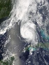
At its peak intensity of 150 mph (240 km/h), Hurricane Charley struck the northern tip of Captiva Island
and the southern tip of North Captiva Island, causing severe damage in both areas. Charley, the strongest hurricane to hit southwest Florida since Hurricane Donna
in 1960, then continued to produce severe damage as it made landfall on the peninsula
near Port Charlotte
. The hurricane continued to the north by northeast along the Peace River corridor, devastating the small cities of Punta Gorda
, Port Charlotte, Cleveland
, Fort Ogden
, Nocatee
, Arcadia
, Zolfo Springs
, Sebring
, and Wauchula
. Zolfo Springs was isolated for nearly two days as masses of large trees, power pole, power lines, transformers, and debris filled the streets. Wauchula sustained gusts to 147 mph (236 km/h), buildings in the downtown areas caved in onto Main Street. Ultimately, the storm passed through the central and eastern parts of the Orlando
metropolitan area, still carrying winds gusting up to 106 mph (171 km/h). Interestingly, the city of Winter Park, north of Orlando, also sustained considerable damage since its many old, large oak trees had not experienced high winds. Falling trees tore down power utilities, smashed cars, and their huge roots lifted underground water and sewer utilities.
Damage in the state totaled to over $13 billion (2004 USD
). Charley, initially expected to hit further north in Tampa
, caught many Floridians off-guard due to a sudden change in the storm's track as it approached the state. Throughout the United States, Charley caused 10 deaths and $15.4 billion in damage (2004 USD), making Charley the second costliest hurricane in United States history at the time (it has since dropped to 5th). Charley was a very small, very fast moving storm, otherwise damage would have been much more severe. Although mitigation and restoration was promised by FEMA to the poor communities of Hardee and DeSoto counties during town meetings, the agency did not pass the cursory planning stages, and the promised reconstruction and compensation never happened.
on August 4. It moved quickly westward and steadily organized over the open Atlantic Ocean, with convection developing in curved bands. The wave continued to develop as it approached the Lesser Antilles
, and became Tropical Depression Three on August 9 while 115 mi (185 km) south-southeast of Barbados
, near the island of Grenada
, however, the threat to Barbados was short-lived. Low upper-level wind shear
and well-defined outflow contributed to further intensification, and the depression strengthened into Tropical Storm Charley on August 10, despite being located in the eastern Caribbean Sea
, which is an area not particularly suited to tropical cyclogenesis
. At this time, the National Hurricane Center
in Miami
designated the name "Charley."
 A strong ridge
of high pressure to the system's north forced Charley to change track quickly to the west-northwest. It continued to strengthen steadily, and Charley became a Category 1 hurricane on August 11, while 90 mi (150 km) south of Kingston, Jamaica
. The storm was being steered around the periphery of the high pressure area, and as a result, Charley changed direction towards the northwest. The following day, the core passed 40 mi (64 km) southwest of the southwest coast of Jamaica
, affecting the island on August 11 and 12. The storm then passed 17 mi (27 km) northeast of Grand Cayman
, reaching Category 2 status just after passing the island. The hurricane continued to strengthen as it turned to the northwest as it rounded the southwest portion of the subtropical ridge
, and became a major hurricane—that is, a storm classified as a Category 3 hurricane or higher—just before making landfall on southern Cuba
. Charley came ashore near Punta Cayamas with maximum sustained winds of 120 mph (195 km/h) and gusts of up to 133 mph (215 km/h), at about 12:30 a.m. EDT
(0430 UTC) on August 13. Charley weakened while crossing the island, and passed about 13 mi (21 km) west of downtown Havana
before weakening to a 110 mph (175 km/h) hurricane.
After emerging from Cuba near Menelao Mora, Hurricane Charley accelerated to the north-northeast, towards the southwest coast of Florida, in response to the approach of an unseasonal mid-tropospheric trough
. This caused the hurricane to pass over the Dry Tortugas
at 8:00 a.m. EDT (1200 UTC) on August 13, with maximum winds of about 110 mph (177 km/h). The strike occurred only 22 hours after Tropical Storm Bonnie
made landfall on St. Vincent Island
; this marks the first time two tropical cyclones hit the same state within a 24-hour period. At this time, Charley rapidly intensified
, strengthening from a 110 mph (175 km/h) hurricane with a minimum central barometric pressure
of 965 mbar
(hPa
; 28.50 inHg) to a 145 mph (230 km/h) hurricane with a pressure of 947 mbar (hPa; 27.64 inHg) in just three hours. The storm continued to strengthen as it turned more to the northeast, and made landfall
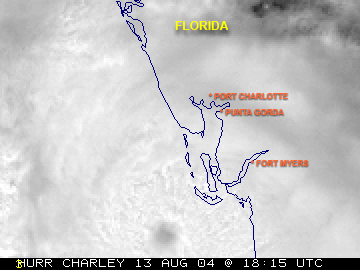
near the island of Cayo Costa, Florida
as a 150 mph (240 km/h) Category 4 hurricane with a pressure of 941 mbar (hPa; 27.49 inHg) at approximately 3:45 p.m. EDT (1945 UTC) on the 13th. An hour later, the hurricane struck Punta Gorda
as a 145 mph (230 km/h) storm. However, the eye had shrunk before landfall, limiting the most powerful winds to an area within 6 nautical miles (11.1 km) of the center.
 Charley weakened considerably due to its passage over land, but still retained sustained winds of about 85 mph (135 km/h) as it passed directly over Orlando
between 8:20 and 9:40 p.m. on August 13 (0020-0140 UTC August 14); gusts of up to 106 mph (171 km/h) were recorded at Orlando International Airport
. It cut a swath of destruction across Florida, also passing near Kissimmee
. The hurricane reemerged into the Atlantic Ocean near Daytona Beach, Florida
as a Category 1 hurricane, but restrengthened slightly over open waters. Continuing to move rapidly to the north-northeast, Charley struck near Cape Romain, South Carolina
as an 80 mph (130 km/h) hurricane, moved offshore briefly, and made its final landfall near North Myrtle Beach
as a minimal hurricane, with winds of 75 mph (120 km/h). Charley then began interacting with an approaching frontal boundary, becoming a tropical storm over southeastern South Carolina
. After moving back into the Atlantic Ocean near Virginia Beach
on August 15, the storm became extratropical
and became embedded in the frontal zone. The extratropical storm continued to move rapidly to the northeast, and was completely absorbed by the front shortly after sunrise on August 15, near southeastern Massachusetts
.
n officials issued a tropical storm warning, which was upgraded to a hurricane warning a day later. In Jamaica
, the threat of the storm forced the country's two airports to close, and also forced two cruise ships to reroute. The Cayman Islands
issued a hurricane warning on the 11th, a day before the hurricane passed near the archipelago
.
Cuba
n government officials issued a hurricane watch for the southern coastline on August 11, two days before the hurricane struck the island. This was upgraded to a hurricane warning on the 12th, 13 ½ hours before Charley made landfall. Because of the threat, the government issued a mandatory evacuation for 235,000 citizens and 159,000 animals in the area of the expected impact. An additional 3,800 residents were evacuated from offshore islands, while 47,000 in Havana
were transported from old, unsafe buildings to safer areas. The people were transported to shelters
provisioned with supplies. In addition, the power grid in southern Cuba was turned off to avoid accidents.
 On August 11, Florida governor Jeb Bush
issued a state of emergency
declaration due to the impending threat Charley presented to the state while the storm was still located south of Jamaica. The National Hurricane Center
issued hurricane warnings for the Florida Keys
and from Cape Sable to the mouth of the Suwannee River
a day prior to Charley's passage through the state, while tropical storm warnings were issued elsewhere throughout Florida
. Because of the threat, 1.9 million people along the Florida west coast were urged to evacuate, including 380,000 residents in the Tampa Bay
area, and 11,000 in the Florida Keys
. It was the largest evacuation order for Pinellas County
history, and the largest evacuation request in Florida since Hurricane Floyd
five years before. Many Floridians remained despite the evacuation order, as authorities estimated that up to a million people would not go to shelters; instead, these residents boarded up their homes and bought supplies to ride out the storm. However, about 1.42 million people evacuated their homes in Florida, and approximately 50,000 residents were placed in shelters throughout the state. Power companies mobilized workers to prepare for the expected widespread power outages. MacDill Air Force Base
, the U.S. military center for the Iraq War, severely limited its staff. Similarly, Kennedy Space Center
, which usually counts with 13,000 on-site personnel, reduced its staff to only 200 people in preparation for the hurricane, and secured all Space Shuttle
s by sealing them in their hangars. Many amusement parks in the Orlando
area closed early, and Walt Disney World's Animal Kingdom
remained closed. This was only the second time in history that a Disney park was closed due to a hurricane, with the other occurrence being after Hurricane Floyd
. The approaching hurricane also forced several cruise ships to reroute their paths, and forced rail service between Miami and New York to shut down.
The rapid strengthening of Charley in the eastern Gulf of Mexico
caught many by surprise. Around five hours before its Florida landfall, Charley was a strong Category 2 hurricane predicted to strengthen its strongest winds to 115 mph (185 km/h) upon its landfall in the Tampa
-Saint Petersburg area. About two hours before landfall, the National Hurricane Center
issued a special advisory, notifying the public that Charley had become a 145 mph (230 km/h) Category 4 hurricane, with a predicted landfall location in the Port Charlotte
area. As a result of this change in forecast, numerous people in the Charlotte County
area were unprepared for the hurricane, despite the fact that the new track prediction was well within the previous forecast's margin of error. National Hurricane Center forecasting intern Robbie Berg publicly blamed the media for misleading residents into believing that a Tampa landfall was inevitable. In addition, he also stated that residents of Port Charlotte had ample warning, as a hurricane warning had been issued for the landfall area 23 hours before, and a hurricane watch had existed for 35 hours.
Several local meteorologists, however, did break with national news predictions of a Tampa Bay landfall as early as the morning of August 13. Jim Farrell of WINK
, Robert Van Winkle WBBH
, Steve Jerve of WFLA
in Tampa, Jim Reif of WZVN
in Fort Myers
, and Tom Terry of WFTV
in Orlando
, all broke with their national news forecasts and stated at around 11 a.m. EDT (1500 UTC) that Charley was going to turn early, striking around Charlotte Harbor
and traveling over Orlando, as would prove to be the case.
Following the Florida landfall, Georgia Governor Sonny Perdue
declared a state of emergency as a precaution against a 4–7 ft (1.2–2.1 m) storm surge and price gouging
. In South Carolina
, Governor Mark Sanford
declared a state of emergency as Charley approached its final landfall. Two coastal counties were forced to evacuate, with state troopers redirecting traffic further inland from Myrtle Beach
. In all, 138,000 evacuated from the Grand Strand area.
One death in Jamaica, four deaths in Cuba, and ten deaths in the United States were directly attributed to Charley. Numerous injuries were reported, as well as twenty indirect deaths in the U.S.
Property damage from Charley in the United States was estimated by the NHC to be $15.0 billion (2004 USD
). At the time, this figure made Charley the second costliest hurricane in United States history, behind 1992
's Hurricane Andrew
's $43.7 billion. However, Charley has since dropped to fifth costliest, due to the damage caused by Hurricane Katrina
and Hurricane Wilma
during the 2005 Atlantic hurricane season
, and Hurricane Ike
in 2008.
, strong winds caused moderate damage to the agricultural sector, with crop and livestock damage totaling to $1.44 million (2004 USD). As the storm traveled along the southwest coast of Jamaica, it caused heavy wind and rain damage. Damage was heaviest in Saint Elizabeth Parish
, where 100 people had to be housed in six shelters. Strong winds downed trees and power lines, causing power outages and blocking roads. Throughout the country, Charley caused $4.1 million (2004 USD) in damage and one fatality. In spite of the close approach that Charley made on the Cayman Islands
, the islands were mostly spared, and were subjected to little damage. Rainfall was light, peaking at 0.9 in (23 mm) in Grand Cayman
, while Cayman Brac
reported tropical storm force winds.
Operationally, forecasters estimated that Charley struck southern Cuba
as a 105 mph (170 km/h) Category 2 hurricane on the Saffir-Simpson scale
. In post-hurricane-season analysis, Charley was determined to have struck southern Cuba as a 120 mph (190 km/h) hurricane; the original estimate was revised based on a report of a 118 mph (190 km/h) sustained wind measurement in Playa Baracoa, and meant that Charley was a major hurricane at landfall. The hurricane produced a storm surge of up to 13.1 ft (4 m) in Playa Cajio; on the other hand, Charley's quick passage caused precipitation
amounts to be small, with the largest total, 5.87 in (149 mm) occurring in Mariel
.
Strong wind gusts downed nearly 1,500 power lines and knocked over 28 large high tension wire towers at a power plant in Mariel. As a result, more than half of the electricity customers in Havana Province were left without power for 12 days after the storm, and all of Pinar del Río Province
was without power for over 11 days. Blackouts continued in areas where power returned. The power outages resulted in lack of drinking water for numerous people, including no potable water in the city of Havana
for four days. As a result, the Cuban government sent water tanks to satisfy the short term need. Similarly, there was a lack of gas for cooking for over a week. However, one Cuban government official stated that it could take up to two months for basic utilities to be returned to many isolated villages.
Near its landfall location, Charley destroyed 290 of the 300 houses in the village, while over 70,000 homes in Havana
were either damaged or destroyed. Numerous hotels reported damage, potentially impacting the important tourism industry in the country. Agricultural damage was heavy, with the hurricane damaging more than 3,000 agricultural institutions. Citrus officials estimated a loss of 15,000 metric tons of grapefruit
on the Isle of Youth
, while strong winds ruined 66,000 metric tons of citrus trees in the Havana area. Charley also destroyed around 57,000 acre
s (230 km²) of fruit trees in the Havana area. Approximately 95% of the sugar cane, bean, and banana crops were affected in Cuban territory. In all, Charley was directly responsible for four deaths in Cuba, and was responsible for $923 million (2004 USD) in property damage, primarily from agricultural losses.
While moving northward to the west of the Florida Keys
, Charley produced moderate winds of 48 mph (77 km/h) with gusts to 60 mph (97 km/h) in Key West
. The winds toppled a few trees, power lines, and unreinforced signs. A boat, knocked loose by strong waves, struck a power transmission line, causing widespread power outages from Marathon
to Key West. On Fort Jefferson
in the Dry Tortugas
, the hurricane produced an estimated storm surge of up to 6 ft (2 m). The surge, combined with incoming waves, caused extensive flooding in the park and damaged numerous docks. In spite of this, property damage was minimal in the area, totaling $160,000 (2004 USD).
 Hurricane Charley passed directly over Captiva Island
near Cayo Costa with peak winds of 150 mph (240 km/h). The Category 4 hurricane produced an estimated storm surge of up to 6.5 ft (2 m) on the island, which is lower than expected for a storm of its intensity. The decrease in the height of the surge was due to the hurricane's small size and its rapid intensification just prior to landfall. Furthermore, the storm surge, combined with the strong pressure gradient, produced a ¼ mi (450 m) inlet on North Captiva Island
, known as Charley's Cut. Strong waves and storm surge caused severe beach erosion and dune damage at various locations. The storm severely damaged five houses, lightly damaged many others, and downed many trees on Gasparilla Island
. At least half of the 300 homes on North Captiva Island were substantially damaged, including ten that were destroyed. On Captiva Island, the strong winds severely damaged most houses, as well as several recreational buildings.
The city of Arcadia
in DeSoto County
saw extreme damage, in spite of being relatively further inland. About 95% of the buildings in the downtown area saw some sort of damage. The only shelter in the town had its roof torn open by the wind, leaving 3,500 evacuees inside unprotected from the onslaught of the storm.
 Hardee County
saw property damage estimated at $750 million (2004 USD), along with six injuries, but no deaths were reported. Charley caused blackouts in the entire county, as well as damage to 3,600 homes and the destruction of 1,400. A radio tower near Sebring
was toppled, along with numerous trees and power poles along the north and east side of Highlands County
. Additionally, there were several reports of severely damaged homes in Polk County near Babson Park and Avon Park
. In Lake Wales, Florida, a sand mine lake encroached into State Road 60 due to wave action and swallowed a car. Additionally, Lake Wales saw 23,000 buildings damaged, as well as the destruction of 739 structures. Seven deaths were reported in the county, one of them determined to be direct.
Throughout the rest of the islands in Sarasota
, Charlotte
, Lee
, and Collier counties
, strong winds from Hurricane Charley caused severe damage to hundreds of buildings and trees. Lee County also endured an 8 feet (2.4 m) storm surge
. These counties were exposed to Charley's eyewall, so they saw the most damage. Due to its small size, the area of most intense damage was located within a 10-mi (16-km) band centered on Charley's track, with additional heavy damage forming an outer band extending 7.5 mi (12 km) to each side of the inner swath of damage. In Charlotte County, 80% of buildings were damaged.
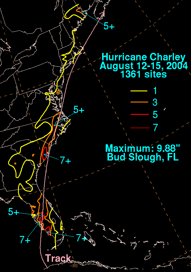
On mainland Florida, Charley produced a peak storm surge of 10–13 feet (3–4 m) at Vanderbilt Beach
near Naples
, along with a much lower surge at its Punta Gorda
landfall. The hurricane dropped generally light rainfall across Florida, with the maximum amount of 9.88 in (251 mm) occurring in Bud Slough in Sarasota County
. In Punta Gorda
's airport, where the hurricane made landfall, wind speeds of up to 90 mph (145 km/h) were measured, alongside gusts of up to 111 mph (180 km/h), before the instrument was blown apart, along with most of the planes and the airport itself. The Charlotte Regional
Medical Center recorded an unofficial peak wind gust of 172 mph (277 km/h). Port Charlotte
's Saint Joseph's Hospital had its roof blown away by Charley's strong winds. Due to the compact nature of the hurricane, the storm's radius of maximum sustained winds
only extended a short distance from its center. In comparison, Fort Myers
, which is only 25 mi (38 km) from where Charley made landfall, experienced sustained winds of only 61 mph (98 km/h) with gusts of 78 mph (125 km/h). In South Florida, Charley spawned several tornadoes, including a long-lived F2
that struck Clewiston
, and five weak tornadoes near the point where the hurricane made landfall.
The most severe damage from Hurricane Charley occurred in Charlotte County. In Boca Grande
, numerous houses sustained extensive roof damage, while thousands of trees and power lines were uprooted or snapped. In Port Charlotte
and Punta Gorda, many buildings, RVs
, and mobile homes were completely destroyed, while other buildings were uproofed due to the powerful winds.
Charley devastated Southwest Florida
, causing $14.6 billion in property damage on the peninsula of Florida alone. Many towns such as Punta Gorda
and Port Charlotte
were leveled by the hurricane. Trees were downed and trailer parks were obliterated as far as Ormond Beach
.
Charley also caused considerable damage in the central and eastern parts of the state. Several possible tornadoes occurred, with severe thunderstorms during the duration of the storm. Winds were estimated to be at 80 mi/h sustained near, and to the north of Okeechobee
, while winds at Orlando International Airport topped out at 105 mi/h in a gust. The storm caused 2 million customers to lose electricity in Florida. In some areas, power was not restored for weeks: 136,000 residents had no electricity a week after Charley's landfall, and 22,000 customers, primarily from cooperative
s, were still waiting for their service to be restored on August 26.
Public schools in some counties in the path of the hurricane were scheduled to be closed for two weeks. In some areas this was necessary because the school buildings were damaged or destroyed: all 59 of Osceola County
's schools were damaged, and one-third of Charlotte County
's were destroyed by Charley's impact. DeSoto County
schools saw $6 million in damage, while Orange County Public Schools
saw $9 million in damage to their educational infrastructure.
Agricultural losses were heavy. In Florida, the second-largest producer of oranges
in the world, damage to the citrus crop was estimated at $200 million (2004 USD), and caused a 50% increase in the price of grapefruit juice. Charley, along with the other storms that hit Florida during 2004, caused a total agricultural loss of $2.2 billion (2004 USD). Other crops, nurseries, buildings, and agricultural equipment also suffered.
 Upon making landfall on northeastern South Carolina
, Charley produced a storm tide that was unofficially measured to up to 7.19 ft (2.19 m) in Myrtle Beach
. Wind gusts were moderate, peaking at 60 mph (95 km/h) in North Myrtle Beach
, though there were several unofficial records of hurricane force gusts. Charley produced moderate rainfall along its path, peaking at over 7 in (178 mm). Moderate winds knocked down numerous trees. Flash flooding occurred in Charleston County
, causing drainage problems. Damage in South Carolina totaled to $20 million (2004 USD).
In North Carolina
, Charley produced an estimated storm surge of 2–3 ft (0.5–1 m), along with waves of up to 8 ft (2.5 m) in height. This produced minor beach erosion along the coastline. Winds gusted from 60 to 70 mph (95 to 110 km/h), causing minor wind damage. Rainfall amounts in the state were moderate, ranging from 4 to 6 in (100 to 150 mm), but still caused flooding across seven North Carolina counties. The hurricane spawned five weak tornadoes across the state, including an F1
in Nags Head
that damaged twenty structures. Charley destroyed 40 houses and damaged 2,231, 231 severely, including 221 damaged beach homes in Sunset Beach
. Damage was the greatest in Brunswick County
, where wind gusts peaked at 85 mph (137 km/h). Crop damage was also heavy in Brunswick County, with 50% of the tobacco crop lost and 30% of the corn and vegetable fields destroyed. Strong winds downed trees and power lines, leaving 65,000 without power. Damage in North Carolina totaled to $25 million (2004 USD).
Tropical Storm Charley produced wind gusts of up to 72 mph (116 km/h) at Chesapeake Light
in Virginia
, causing scattered power outages. Rainfall was light, ranging from 2 to 3.7 in (50 to 94 mm). Charley produced one tornado in Chesapeake
and one in Virginia Beach
. In Rhode Island
, one man drowned in a rip current.
George W. Bush
declared Florida a federal disaster area. He later reflected on the government response to Charley:
U.S. Health and Human Services Secretary Tommy Thompson
released $11 million in additional aid and other assistance to Florida, with $10 million to be earmarked to Head Start facilities that need repair or new supplies, another $1 million was provided to the DeSoto Memorial Hospital in Arcadia and Osceola Regional Medical Center in Kissimmee, and $200,000 would be spent to provide services to senior citizens. Across Florida, 114 food service operations and eight comfort stations were set up. FEMA opened four disaster recovery centers.
. As a result, the name will never again be used for an Atlantic tropical cyclone. The name was replaced with Colin
for the 2010 Atlantic hurricane season
.
2004 Atlantic hurricane season
The 2004 Atlantic hurricane season officially began on June 1, 2004, and lasted until November 30, 2004. These dates conventionally delimit the period of each year when most tropical cyclones form in the Atlantic basin...
. Charley lasted from August 9 to August 15, and at its peak intensity it attained 150 mph (240 km/h) winds, making it a strong Category 4 hurricane on the Saffir-Simpson Hurricane Scale
Saffir-Simpson Hurricane Scale
The Saffir–Simpson Hurricane Scale , or the Saffir–Simpson Hurricane Wind Scale , classifies hurricanes — Western Hemisphere tropical cyclones that exceed the intensities of tropical depressions and tropical storms — into five categories distinguished by the intensities of their sustained winds...
. The storm made landfall
Landfall (meteorology)
Landfall is the event of a tropical cyclone or a waterspout coming onto land after being over water. When a waterspout makes landfall it is reclassified as a tornado, which can then cause damage inland...
in southwestern Florida
Florida
Florida is a state in the southeastern United States, located on the nation's Atlantic and Gulf coasts. It is bordered to the west by the Gulf of Mexico, to the north by Alabama and Georgia and to the east by the Atlantic Ocean. With a population of 18,801,310 as measured by the 2010 census, it...
at maximum strength, thus making it the strongest hurricane to hit the United States since Hurricane Andrew
Hurricane Andrew
Hurricane Andrew was the third Category 5 hurricane to make landfall in the United States, after the Labor Day Hurricane of 1935 and Hurricane Camille in 1969. Andrew was the first named storm and only major hurricane of the otherwise inactive 1992 Atlantic hurricane season...
struck Florida twelve years before, in 1992
1992 Atlantic hurricane season
The 1992 Atlantic hurricane season had one of the latest dates on record for the first named storm. The season officially began on June 1, 1992, and lasted until November 30, 1992. It was the least active hurricane season in nine years due to a strong El Niño...
.
After moving briskly through the Caribbean Sea
Caribbean Sea
The Caribbean Sea is a sea of the Atlantic Ocean located in the tropics of the Western hemisphere. It is bounded by Mexico and Central America to the west and southwest, to the north by the Greater Antilles, and to the east by the Lesser Antilles....
, Charley crossed Cuba
Cuba
The Republic of Cuba is an island nation in the Caribbean. The nation of Cuba consists of the main island of Cuba, the Isla de la Juventud, and several archipelagos. Havana is the largest city in Cuba and the country's capital. Santiago de Cuba is the second largest city...
on Friday, August 13 as a Category 3 hurricane, causing heavy damage and four deaths. That same day, the hurricane crossed over the Dry Tortugas
Dry Tortugas
The Dry Tortugas are a small group of islands, located at the end of the Florida Keys, USA, about west of Key West, and west of the Marquesas Keys, the closest islands. Still further west is the Tortugas Bank, which is completely submerged. The first Europeans to discover the islands were the...
, just 22 hours after Tropical Storm Bonnie
Tropical Storm Bonnie (2004)
Tropical Storm Bonnie was a small tropical storm that made landfall on Florida in August 2004. The second storm of the 2004 Atlantic hurricane season, Bonnie developed from a tropical wave on August 3 to the east of the Lesser Antilles. After moving through the islands, its fast forward motion...
struck northwestern Florida
Florida
Florida is a state in the southeastern United States, located on the nation's Atlantic and Gulf coasts. It is bordered to the west by the Gulf of Mexico, to the north by Alabama and Georgia and to the east by the Atlantic Ocean. With a population of 18,801,310 as measured by the 2010 census, it...
. This was the first time in history that two tropical cyclones struck the same state in a 24-hour time period.
At its peak intensity of 150 mph (240 km/h), Hurricane Charley struck the northern tip of Captiva Island
Captiva Island
Captiva Island is an island in Lee County in southwest Florida, located just offshore in the Gulf of Mexico.-History:According to local folklore, Captiva got its name because the pirate captain José Gaspar held his female prisoners on the island for ransom or worse...
and the southern tip of North Captiva Island, causing severe damage in both areas. Charley, the strongest hurricane to hit southwest Florida since Hurricane Donna
Hurricane Donna
Hurricane Donna in the 1960 Atlantic hurricane season was a Cape Verde-type hurricane which moved across the Leeward Islands, Puerto Rico, Hispanola, Cuba, The Bahamas, and every state on the East Coast of the United States...
in 1960, then continued to produce severe damage as it made landfall on the peninsula
Southwest Florida
Southwest Florida is a region of Florida , United States located along its gulf coast, south of the Tampa Bay area, west of Lake Okeechobee and mostly north of the Everglades...
near Port Charlotte
Port Charlotte, Florida
Port Charlotte is a census-designated place in Charlotte County, Florida, United States. The population was 46,451 at the 2000 census. It is part of the Punta Gorda Metropolitan Statistical Area.-History:...
. The hurricane continued to the north by northeast along the Peace River corridor, devastating the small cities of Punta Gorda
Punta Gorda, Florida
Punta Gorda is a city in Charlotte County, Florida, United States. According to the U.S. Census Bureau estimates of 2007, the city had a population of 16,762. It is the county seat of Charlotte County and the only incorporated municipality in the county...
, Port Charlotte, Cleveland
Cleveland, Florida
Cleveland is a census-designated place in Charlotte County, Florida, United States. The population was 3,268 at the 2000 census. It is part of the Punta Gorda Metropolitan Statistical Area.-Geography:Cleveland is located at ....
, Fort Ogden
Fort Ogden, Florida
Fort Ogden is an unincorporated community in DeSoto County, Florida, United States. It is located about southwest of the city of Arcadia....
, Nocatee
Nocatee, DeSoto County, Florida
Nocatee is an unincorporated community in DeSoto County, Florida, United States. It is located just south southwest of the city of Arcadia....
, Arcadia
Arcadia, Florida
Arcadia is a city in DeSoto County, Florida, United States. The population was 6,604 as of the 2000 census. According to the U.S Census estimates of 2005, the city grew to 7,151. It is the county seat of DeSoto County; it is also DeSoto County's only incorporated community. On October 27, 2009,...
, Zolfo Springs
Zolfo Springs, Florida
Zolfo Springs is a town in Hardee County, Florida, United States. The population was 1,641 at the 2000 census. According to the U.S. Census Bureau's 2004 estimates, the town had a population of 1,659.-Geography:...
, Sebring
Sebring, Florida
Sebring is a city in Highlands County, Florida, United States, nicknamed "The City on the Circle", in reference to Circle Drive, the center of the Sebring Downtown Historic District...
, and Wauchula
Wauchula, Florida
Wauchula is a city located in Hardee County, Florida, United States, and had a population of 4,368 at the 2000 census. According to the U.S. Census Bureau's 2004 estimates, the city had a population of 4,441.It is the county seat of Hardee County...
. Zolfo Springs was isolated for nearly two days as masses of large trees, power pole, power lines, transformers, and debris filled the streets. Wauchula sustained gusts to 147 mph (236 km/h), buildings in the downtown areas caved in onto Main Street. Ultimately, the storm passed through the central and eastern parts of the Orlando
Orlando, Florida
Orlando is a city in the central region of the U.S. state of Florida. It is the county seat of Orange County, and the center of the Greater Orlando metropolitan area. According to the 2010 US Census, the city had a population of 238,300, making Orlando the 79th largest city in the United States...
metropolitan area, still carrying winds gusting up to 106 mph (171 km/h). Interestingly, the city of Winter Park, north of Orlando, also sustained considerable damage since its many old, large oak trees had not experienced high winds. Falling trees tore down power utilities, smashed cars, and their huge roots lifted underground water and sewer utilities.
Damage in the state totaled to over $13 billion (2004 USD
United States dollar
The United States dollar , also referred to as the American dollar, is the official currency of the United States of America. It is divided into 100 smaller units called cents or pennies....
). Charley, initially expected to hit further north in Tampa
Tampa, Florida
Tampa is a city in the U.S. state of Florida. It serves as the county seat for Hillsborough County. Tampa is located on the west coast of Florida. The population of Tampa in 2010 was 335,709....
, caught many Floridians off-guard due to a sudden change in the storm's track as it approached the state. Throughout the United States, Charley caused 10 deaths and $15.4 billion in damage (2004 USD), making Charley the second costliest hurricane in United States history at the time (it has since dropped to 5th). Charley was a very small, very fast moving storm, otherwise damage would have been much more severe. Although mitigation and restoration was promised by FEMA to the poor communities of Hardee and DeSoto counties during town meetings, the agency did not pass the cursory planning stages, and the promised reconstruction and compensation never happened.
Meteorological history
Charley began as a tropical wave that moved off the west coast of AfricaAfrica
Africa is the world's second largest and second most populous continent, after Asia. At about 30.2 million km² including adjacent islands, it covers 6% of the Earth's total surface area and 20.4% of the total land area...
on August 4. It moved quickly westward and steadily organized over the open Atlantic Ocean, with convection developing in curved bands. The wave continued to develop as it approached the Lesser Antilles
Lesser Antilles
The Lesser Antilles are a long, partly volcanic island arc in the Western Hemisphere. Most of its islands form the eastern boundary of the Caribbean Sea with the Atlantic Ocean, with the remainder located in the southern Caribbean just north of South America...
, and became Tropical Depression Three on August 9 while 115 mi (185 km) south-southeast of Barbados
Barbados
Barbados is an island country in the Lesser Antilles. It is in length and as much as in width, amounting to . It is situated in the western area of the North Atlantic and 100 kilometres east of the Windward Islands and the Caribbean Sea; therein, it is about east of the islands of Saint...
, near the island of Grenada
Grenada
Grenada is an island country and Commonwealth Realm consisting of the island of Grenada and six smaller islands at the southern end of the Grenadines in the southeastern Caribbean Sea...
, however, the threat to Barbados was short-lived. Low upper-level wind shear
Wind shear
Wind shear, sometimes referred to as windshear or wind gradient, is a difference in wind speed and direction over a relatively short distance in the atmosphere...
and well-defined outflow contributed to further intensification, and the depression strengthened into Tropical Storm Charley on August 10, despite being located in the eastern Caribbean Sea
Caribbean Sea
The Caribbean Sea is a sea of the Atlantic Ocean located in the tropics of the Western hemisphere. It is bounded by Mexico and Central America to the west and southwest, to the north by the Greater Antilles, and to the east by the Lesser Antilles....
, which is an area not particularly suited to tropical cyclogenesis
Tropical cyclogenesis
Tropical cyclogenesis is the term that describes the development and strengthening of a tropical cyclone in the atmosphere. The mechanisms through which tropical cyclogenesis occurs are distinctly different from those through which mid-latitude cyclogenesis occurs...
. At this time, the National Hurricane Center
National Hurricane Center
The National Hurricane Center , located at Florida International University in Miami, Florida, is the division of the National Weather Service responsible for tracking and predicting weather systems within the tropics between the Prime Meridian and the 140th meridian west poleward to the 30th...
in Miami
Miami, Florida
Miami is a city located on the Atlantic coast in southeastern Florida and the county seat of Miami-Dade County, the most populous county in Florida and the eighth-most populous county in the United States with a population of 2,500,625...
designated the name "Charley."
Ridge (meteorology)
A ridge is an elongated region of relatively high atmospheric pressure, the opposite of a trough....
of high pressure to the system's north forced Charley to change track quickly to the west-northwest. It continued to strengthen steadily, and Charley became a Category 1 hurricane on August 11, while 90 mi (150 km) south of Kingston, Jamaica
Kingston, Jamaica
Kingston is the capital and largest city of Jamaica, located on the southeastern coast of the island. It faces a natural harbour protected by the Palisadoes, a long sand spit which connects the town of Port Royal and the Norman Manley International Airport to the rest of the island...
. The storm was being steered around the periphery of the high pressure area, and as a result, Charley changed direction towards the northwest. The following day, the core passed 40 mi (64 km) southwest of the southwest coast of Jamaica
Jamaica
Jamaica is an island nation of the Greater Antilles, in length, up to in width and 10,990 square kilometres in area. It is situated in the Caribbean Sea, about south of Cuba, and west of Hispaniola, the island harbouring the nation-states Haiti and the Dominican Republic...
, affecting the island on August 11 and 12. The storm then passed 17 mi (27 km) northeast of Grand Cayman
Grand Cayman
Grand Cayman is the largest of the three Cayman Islands and the location of the nation's capital, George Town. In relation to the other two Cayman Islands, it is approximately 75 miles southwest of Little Cayman and 90 miles southwest of Cayman Brac.-Geography:Grand Cayman encompasses 76% of...
, reaching Category 2 status just after passing the island. The hurricane continued to strengthen as it turned to the northwest as it rounded the southwest portion of the subtropical ridge
Subtropical ridge
The subtropical ridge is a significant belt of high pressure situated around the latitudes of 30°N in the Northern Hemisphere and 30°S in the Southern Hemisphere. It is characterized by mostly calm winds, which acts to reduce air quality under its axis by causing fog overnight, and haze during...
, and became a major hurricane—that is, a storm classified as a Category 3 hurricane or higher—just before making landfall on southern Cuba
Cuba
The Republic of Cuba is an island nation in the Caribbean. The nation of Cuba consists of the main island of Cuba, the Isla de la Juventud, and several archipelagos. Havana is the largest city in Cuba and the country's capital. Santiago de Cuba is the second largest city...
. Charley came ashore near Punta Cayamas with maximum sustained winds of 120 mph (195 km/h) and gusts of up to 133 mph (215 km/h), at about 12:30 a.m. EDT
Eastern Time Zone
The Eastern Time Zone of the United States and Canada is a time zone that falls mostly along the east coast of North America. Its UTC time offset is −5 hrs during standard time and −4 hrs during daylight saving time...
(0430 UTC) on August 13. Charley weakened while crossing the island, and passed about 13 mi (21 km) west of downtown Havana
Havana
Havana is the capital city, province, major port, and leading commercial centre of Cuba. The city proper has a population of 2.1 million inhabitants, and it spans a total of — making it the largest city in the Caribbean region, and the most populous...
before weakening to a 110 mph (175 km/h) hurricane.
After emerging from Cuba near Menelao Mora, Hurricane Charley accelerated to the north-northeast, towards the southwest coast of Florida, in response to the approach of an unseasonal mid-tropospheric trough
Trough (meteorology)
A trough is an elongated region of relatively low atmospheric pressure, often associated with fronts.Unlike fronts, there is not a universal symbol for a trough on a weather chart. The weather charts in some countries or regions mark troughs by a line. In the United States, a trough may be marked...
. This caused the hurricane to pass over the Dry Tortugas
Dry Tortugas
The Dry Tortugas are a small group of islands, located at the end of the Florida Keys, USA, about west of Key West, and west of the Marquesas Keys, the closest islands. Still further west is the Tortugas Bank, which is completely submerged. The first Europeans to discover the islands were the...
at 8:00 a.m. EDT (1200 UTC) on August 13, with maximum winds of about 110 mph (177 km/h). The strike occurred only 22 hours after Tropical Storm Bonnie
Tropical Storm Bonnie (2004)
Tropical Storm Bonnie was a small tropical storm that made landfall on Florida in August 2004. The second storm of the 2004 Atlantic hurricane season, Bonnie developed from a tropical wave on August 3 to the east of the Lesser Antilles. After moving through the islands, its fast forward motion...
made landfall on St. Vincent Island
St. Vincent Island, Florida
St. Vincent Island is the western-most of 4 barrier islands in the northwestern Florida Gulf coast which include Cape St. George Island, St. George Island and Dog Island. St. Vincent Island is located just offshore in Franklin County, Florida south southeast of Cape San Blas and north of Cape St...
; this marks the first time two tropical cyclones hit the same state within a 24-hour period. At this time, Charley rapidly intensified
Rapid deepening
Rapid deepening, also known as rapid intensification, is a meteorological condition that occurs when the minimum sea-level atmospheric pressure of a tropical cyclone decreases drastically in a short period of time. The National Weather Service describes rapid deepening as a decrease of...
, strengthening from a 110 mph (175 km/h) hurricane with a minimum central barometric pressure
Atmospheric pressure
Atmospheric pressure is the force per unit area exerted into a surface by the weight of air above that surface in the atmosphere of Earth . In most circumstances atmospheric pressure is closely approximated by the hydrostatic pressure caused by the weight of air above the measurement point...
of 965 mbar
Bar (unit)
The bar is a unit of pressure equal to 100 kilopascals, and roughly equal to the atmospheric pressure on Earth at sea level. Other units derived from the bar are the megabar , kilobar , decibar , centibar , and millibar...
(hPa
Pascal (unit)
The pascal is the SI derived unit of pressure, internal pressure, stress, Young's modulus and tensile strength, named after the French mathematician, physicist, inventor, writer, and philosopher Blaise Pascal. It is a measure of force per unit area, defined as one newton per square metre...
; 28.50 inHg) to a 145 mph (230 km/h) hurricane with a pressure of 947 mbar (hPa; 27.64 inHg) in just three hours. The storm continued to strengthen as it turned more to the northeast, and made landfall
Landfall (meteorology)
Landfall is the event of a tropical cyclone or a waterspout coming onto land after being over water. When a waterspout makes landfall it is reclassified as a tornado, which can then cause damage inland...
near the island of Cayo Costa, Florida
Cayo Costa State Park
Cayo Costa State Park is a Florida State Park on La Costa Island, which is directly south of Boca Grande, Florida, west of Cape Coral and just north of Sanibel and Captiva Islands...
as a 150 mph (240 km/h) Category 4 hurricane with a pressure of 941 mbar (hPa; 27.49 inHg) at approximately 3:45 p.m. EDT (1945 UTC) on the 13th. An hour later, the hurricane struck Punta Gorda
Punta Gorda, Florida
Punta Gorda is a city in Charlotte County, Florida, United States. According to the U.S. Census Bureau estimates of 2007, the city had a population of 16,762. It is the county seat of Charlotte County and the only incorporated municipality in the county...
as a 145 mph (230 km/h) storm. However, the eye had shrunk before landfall, limiting the most powerful winds to an area within 6 nautical miles (11.1 km) of the center.
Orlando, Florida
Orlando is a city in the central region of the U.S. state of Florida. It is the county seat of Orange County, and the center of the Greater Orlando metropolitan area. According to the 2010 US Census, the city had a population of 238,300, making Orlando the 79th largest city in the United States...
between 8:20 and 9:40 p.m. on August 13 (0020-0140 UTC August 14); gusts of up to 106 mph (171 km/h) were recorded at Orlando International Airport
Orlando International Airport
Orlando International Airport is a major international airport located southeast of the central business district of Orlando. It is the second busiest airport in Florida, after Miami International Airport...
. It cut a swath of destruction across Florida, also passing near Kissimmee
Kissimmee, Florida
Kissimmee is a city in Osceola County, Florida, United States. As of the 2010 census, the population was 59,682. It is the county seat of Osceola County...
. The hurricane reemerged into the Atlantic Ocean near Daytona Beach, Florida
Daytona Beach, Florida
Daytona Beach is a city in Volusia County, Florida, USA. According to 2008 U.S. Census Bureau estimates, the city has a population of 64,211. Daytona Beach is a principal city of the Deltona – Daytona Beach – Ormond Beach, Florida Metropolitan Statistical Area, which the census bureau estimated had...
as a Category 1 hurricane, but restrengthened slightly over open waters. Continuing to move rapidly to the north-northeast, Charley struck near Cape Romain, South Carolina
South Carolina
South Carolina is a state in the Deep South of the United States that borders Georgia to the south, North Carolina to the north, and the Atlantic Ocean to the east. Originally part of the Province of Carolina, the Province of South Carolina was one of the 13 colonies that declared independence...
as an 80 mph (130 km/h) hurricane, moved offshore briefly, and made its final landfall near North Myrtle Beach
North Myrtle Beach, South Carolina
North Myrtle Beach is a coastal resort city in Horry County, South Carolina, United States. It was created in 1968 from four existing municipalities north of Myrtle Beach, and serves as one of the primary tourist towns along the Grand Strand...
as a minimal hurricane, with winds of 75 mph (120 km/h). Charley then began interacting with an approaching frontal boundary, becoming a tropical storm over southeastern South Carolina
South Carolina
South Carolina is a state in the Deep South of the United States that borders Georgia to the south, North Carolina to the north, and the Atlantic Ocean to the east. Originally part of the Province of Carolina, the Province of South Carolina was one of the 13 colonies that declared independence...
. After moving back into the Atlantic Ocean near Virginia Beach
Virginia Beach, Virginia
Virginia Beach is an independent city located in the Hampton Roads metropolitan area of Virginia, on the Atlantic Ocean at the mouth of the Chesapeake Bay...
on August 15, the storm became extratropical
Extratropical cyclone
Extratropical cyclones, sometimes called mid-latitude cyclones or wave cyclones, are a group of cyclones defined as synoptic scale low pressure weather systems that occur in the middle latitudes of the Earth having neither tropical nor polar characteristics, and are connected with fronts and...
and became embedded in the frontal zone. The extratropical storm continued to move rapidly to the northeast, and was completely absorbed by the front shortly after sunrise on August 15, near southeastern Massachusetts
Massachusetts
The Commonwealth of Massachusetts is a state in the New England region of the northeastern United States of America. It is bordered by Rhode Island and Connecticut to the south, New York to the west, and Vermont and New Hampshire to the north; at its east lies the Atlantic Ocean. As of the 2010...
.
Preparations
On August 10, two days before the hurricane passed near the island, JamaicaJamaica
Jamaica is an island nation of the Greater Antilles, in length, up to in width and 10,990 square kilometres in area. It is situated in the Caribbean Sea, about south of Cuba, and west of Hispaniola, the island harbouring the nation-states Haiti and the Dominican Republic...
n officials issued a tropical storm warning, which was upgraded to a hurricane warning a day later. In Jamaica
Jamaica
Jamaica is an island nation of the Greater Antilles, in length, up to in width and 10,990 square kilometres in area. It is situated in the Caribbean Sea, about south of Cuba, and west of Hispaniola, the island harbouring the nation-states Haiti and the Dominican Republic...
, the threat of the storm forced the country's two airports to close, and also forced two cruise ships to reroute. The Cayman Islands
Cayman Islands
The Cayman Islands is a British Overseas Territory and overseas territory of the European Union located in the western Caribbean Sea. The territory comprises the three islands of Grand Cayman, Cayman Brac, and Little Cayman, located south of Cuba and northwest of Jamaica...
issued a hurricane warning on the 11th, a day before the hurricane passed near the archipelago
Archipelago
An archipelago , sometimes called an island group, is a chain or cluster of islands. The word archipelago is derived from the Greek ἄρχι- – arkhi- and πέλαγος – pélagos through the Italian arcipelago...
.
Cuba
Cuba
The Republic of Cuba is an island nation in the Caribbean. The nation of Cuba consists of the main island of Cuba, the Isla de la Juventud, and several archipelagos. Havana is the largest city in Cuba and the country's capital. Santiago de Cuba is the second largest city...
n government officials issued a hurricane watch for the southern coastline on August 11, two days before the hurricane struck the island. This was upgraded to a hurricane warning on the 12th, 13 ½ hours before Charley made landfall. Because of the threat, the government issued a mandatory evacuation for 235,000 citizens and 159,000 animals in the area of the expected impact. An additional 3,800 residents were evacuated from offshore islands, while 47,000 in Havana
Havana
Havana is the capital city, province, major port, and leading commercial centre of Cuba. The city proper has a population of 2.1 million inhabitants, and it spans a total of — making it the largest city in the Caribbean region, and the most populous...
were transported from old, unsafe buildings to safer areas. The people were transported to shelters
Emergency shelter
Emergency shelters are places for people to live temporarily when they can't live in their previous residence, similar to homeless shelters. The main difference is that an emergency shelter typically specializes in people fleeing a specific type of situation, such as natural or man-made disasters,...
provisioned with supplies. In addition, the power grid in southern Cuba was turned off to avoid accidents.
Jeb Bush
John Ellis "Jeb" Bush is an American politician who served as the 43rd Governor of Florida from 1999 to 2007. He is a prominent member of the Bush family: the second son of former President George H. W. Bush and former First Lady Barbara Bush; the younger brother of former President George W...
issued a state of emergency
State of emergency
A state of emergency is a governmental declaration that may suspend some normal functions of the executive, legislative and judicial powers, alert citizens to change their normal behaviours, or order government agencies to implement emergency preparedness plans. It can also be used as a rationale...
declaration due to the impending threat Charley presented to the state while the storm was still located south of Jamaica. The National Hurricane Center
National Hurricane Center
The National Hurricane Center , located at Florida International University in Miami, Florida, is the division of the National Weather Service responsible for tracking and predicting weather systems within the tropics between the Prime Meridian and the 140th meridian west poleward to the 30th...
issued hurricane warnings for the Florida Keys
Florida Keys
The Florida Keys are a coral archipelago in southeast United States. They begin at the southeastern tip of the Florida peninsula, about south of Miami, and extend in a gentle arc south-southwest and then westward to Key West, the westernmost of the inhabited islands, and on to the uninhabited Dry...
and from Cape Sable to the mouth of the Suwannee River
Suwannee River
The Suwannee River is a major river of southern Georgia and northern Florida in the United States. It is a wild blackwater river, about long. The Suwannee River is the site of the prehistoric Suwannee Straits which separated peninsular Florida from the panhandle.-Geography:The river rises in the...
a day prior to Charley's passage through the state, while tropical storm warnings were issued elsewhere throughout Florida
Florida
Florida is a state in the southeastern United States, located on the nation's Atlantic and Gulf coasts. It is bordered to the west by the Gulf of Mexico, to the north by Alabama and Georgia and to the east by the Atlantic Ocean. With a population of 18,801,310 as measured by the 2010 census, it...
. Because of the threat, 1.9 million people along the Florida west coast were urged to evacuate, including 380,000 residents in the Tampa Bay
Tampa Bay
Tampa Bay is a large natural harbor and estuary along the Gulf of Mexico on the west central coast of Florida, comprising Hillsborough Bay, Old Tampa Bay, Middle Tampa Bay, and Lower Tampa Bay."Tampa Bay" is not the name of any municipality...
area, and 11,000 in the Florida Keys
Florida Keys
The Florida Keys are a coral archipelago in southeast United States. They begin at the southeastern tip of the Florida peninsula, about south of Miami, and extend in a gentle arc south-southwest and then westward to Key West, the westernmost of the inhabited islands, and on to the uninhabited Dry...
. It was the largest evacuation order for Pinellas County
Pinellas County, Florida
Pinellas County is a county located in the state of Florida. Its county seat is Clearwater, Florida, and its largest city is St. Petersburg. This county is contained entirely within the telephone area code 727, except for some sections of Oldsmar, which have the area code 813...
history, and the largest evacuation request in Florida since Hurricane Floyd
Hurricane Floyd
Hurricane Floyd was the sixth named storm, fourth hurricane, and third major hurricane in the 1999 Atlantic hurricane season. Floyd triggered the third largest evacuation in US history when 2.6 million coastal residents of five states were ordered from their homes as it approached...
five years before. Many Floridians remained despite the evacuation order, as authorities estimated that up to a million people would not go to shelters; instead, these residents boarded up their homes and bought supplies to ride out the storm. However, about 1.42 million people evacuated their homes in Florida, and approximately 50,000 residents were placed in shelters throughout the state. Power companies mobilized workers to prepare for the expected widespread power outages. MacDill Air Force Base
MacDill Air Force Base
MacDill Air Force Base is an active United States Air Force base located approximately south-southwest of downtown Tampa, Florida...
, the U.S. military center for the Iraq War, severely limited its staff. Similarly, Kennedy Space Center
Kennedy Space Center
The John F. Kennedy Space Center is the NASA installation that has been the launch site for every United States human space flight since 1968. Although such flights are currently on hiatus, KSC continues to manage and operate unmanned rocket launch facilities for America's civilian space program...
, which usually counts with 13,000 on-site personnel, reduced its staff to only 200 people in preparation for the hurricane, and secured all Space Shuttle
Space Shuttle
The Space Shuttle was a manned orbital rocket and spacecraft system operated by NASA on 135 missions from 1981 to 2011. The system combined rocket launch, orbital spacecraft, and re-entry spaceplane with modular add-ons...
s by sealing them in their hangars. Many amusement parks in the Orlando
Orlando, Florida
Orlando is a city in the central region of the U.S. state of Florida. It is the county seat of Orange County, and the center of the Greater Orlando metropolitan area. According to the 2010 US Census, the city had a population of 238,300, making Orlando the 79th largest city in the United States...
area closed early, and Walt Disney World's Animal Kingdom
Disney's Animal Kingdom
Disney's Animal Kingdom is an animal theme park located at the Walt Disney World Resort. The fourth park built at the resort, it opened on April 22, 1998, and it is the largest single Disney theme park in the world, covering more than . It is also the first Disney theme park to be themed entirely...
remained closed. This was only the second time in history that a Disney park was closed due to a hurricane, with the other occurrence being after Hurricane Floyd
Hurricane Floyd
Hurricane Floyd was the sixth named storm, fourth hurricane, and third major hurricane in the 1999 Atlantic hurricane season. Floyd triggered the third largest evacuation in US history when 2.6 million coastal residents of five states were ordered from their homes as it approached...
. The approaching hurricane also forced several cruise ships to reroute their paths, and forced rail service between Miami and New York to shut down.
The rapid strengthening of Charley in the eastern Gulf of Mexico
Gulf of Mexico
The Gulf of Mexico is a partially landlocked ocean basin largely surrounded by the North American continent and the island of Cuba. It is bounded on the northeast, north and northwest by the Gulf Coast of the United States, on the southwest and south by Mexico, and on the southeast by Cuba. In...
caught many by surprise. Around five hours before its Florida landfall, Charley was a strong Category 2 hurricane predicted to strengthen its strongest winds to 115 mph (185 km/h) upon its landfall in the Tampa
Tampa, Florida
Tampa is a city in the U.S. state of Florida. It serves as the county seat for Hillsborough County. Tampa is located on the west coast of Florida. The population of Tampa in 2010 was 335,709....
-Saint Petersburg area. About two hours before landfall, the National Hurricane Center
National Hurricane Center
The National Hurricane Center , located at Florida International University in Miami, Florida, is the division of the National Weather Service responsible for tracking and predicting weather systems within the tropics between the Prime Meridian and the 140th meridian west poleward to the 30th...
issued a special advisory, notifying the public that Charley had become a 145 mph (230 km/h) Category 4 hurricane, with a predicted landfall location in the Port Charlotte
Port Charlotte, Florida
Port Charlotte is a census-designated place in Charlotte County, Florida, United States. The population was 46,451 at the 2000 census. It is part of the Punta Gorda Metropolitan Statistical Area.-History:...
area. As a result of this change in forecast, numerous people in the Charlotte County
Charlotte County, Florida
Charlotte County is a county located in the U.S. state of Florida. As of 2000, the population was 141,627. In 2005, the population of the MSA was 154,030.The U.S. Census Bureau 2007 estimate for the county was 152,814...
area were unprepared for the hurricane, despite the fact that the new track prediction was well within the previous forecast's margin of error. National Hurricane Center forecasting intern Robbie Berg publicly blamed the media for misleading residents into believing that a Tampa landfall was inevitable. In addition, he also stated that residents of Port Charlotte had ample warning, as a hurricane warning had been issued for the landfall area 23 hours before, and a hurricane watch had existed for 35 hours.
Several local meteorologists, however, did break with national news predictions of a Tampa Bay landfall as early as the morning of August 13. Jim Farrell of WINK
WINK-TV
WINK-TV, virtual channel 11, is the CBS-affiliated television station for Southwest Florida that is licensed to Fort Myers. It broadcasts a high definition digital signal on UHF channel 50 from a transmitter north of Fort Myers Shores near the Lee and Charlotte County line in Punta Gorda. The...
, Robert Van Winkle WBBH
WBBH-TV
WBBH-TV is the NBC-affiliated television station for Southwest Florida licensed to Fort Myers. It broadcasts a high definition digital signal on UHF channel 15 from a transmitter in Southeastern Punta Gorda along SR 31. Owned by the Waterman Broadcasting Corporation, WBBH operates ABC affiliate...
, Steve Jerve of WFLA
WFLA-TV
WFLA-TV, virtual channel 8, is the NBC-affiliated television station in Tampa/St. Petersburg, Florida. The station is the flagship station of its owner and operator, Media General. Its transmitter is located in Riverview, Hillsborough County, Florida. WFLA is the only station in the market to be...
in Tampa, Jim Reif of WZVN
WZVN-TV
WZVN-TV is the ABC-affiliated television station for Southwest Florida licensed to Naples. It broadcasts a high definition digital signal on UHF channel 41 from a transmitter in Southeastern Punta Gorda along SR 31. The station can also be seen on Comcast channel 7 and in high definition on...
in Fort Myers
Fort Myers, Florida
Fort Myers is the county seat and commercial center of Lee County, Florida, United States. Its population was 62,298 in the 2010 census, a 29.23 percent increase over the 2000 figure....
, and Tom Terry of WFTV
WFTV
WFTV, channel 9, is the ABC-affiliated television station for Central Florida that is licensed to Orlando. It broadcasts a high definition digital signal on UHF channel 39 from a transmitter between Bithlo and Christmas. Owned by Cox Enterprises, WFTV is sister to Independent WRDQ. The two stations...
in Orlando
Orlando, Florida
Orlando is a city in the central region of the U.S. state of Florida. It is the county seat of Orange County, and the center of the Greater Orlando metropolitan area. According to the 2010 US Census, the city had a population of 238,300, making Orlando the 79th largest city in the United States...
, all broke with their national news forecasts and stated at around 11 a.m. EDT (1500 UTC) that Charley was going to turn early, striking around Charlotte Harbor
Charlotte Harbor (estuary)
Charlotte Harbor Estuary is a natural estuary spanning the west coast of Florida from Venice to Bonita Springs on the Gulf of Mexico and is one of the most productive wetlands in Florida...
and traveling over Orlando, as would prove to be the case.
Following the Florida landfall, Georgia Governor Sonny Perdue
Sonny Perdue
George Ervin "Sonny" Perdue III, was the 81st Governor of Georgia. Upon his inauguration in January 2003, he became the first Republican governor of Georgia since Benjamin F. Conley served during Reconstruction in the 1870s....
declared a state of emergency as a precaution against a 4–7 ft (1.2–2.1 m) storm surge and price gouging
Price gouging
Price gouging is a pejorative term referring to a situation in which a seller prices goods or commodities much higher than is considered reasonable or fair. In precise, legal usage, it is the name of a crime that applies in some of the United States during civil emergencies...
. In South Carolina
South Carolina
South Carolina is a state in the Deep South of the United States that borders Georgia to the south, North Carolina to the north, and the Atlantic Ocean to the east. Originally part of the Province of Carolina, the Province of South Carolina was one of the 13 colonies that declared independence...
, Governor Mark Sanford
Mark Sanford
Marshall Clement "Mark" Sanford Jr. is an American politician from South Carolina, who was the 115th Governor of South Carolina from 2003 to 2011....
declared a state of emergency as Charley approached its final landfall. Two coastal counties were forced to evacuate, with state troopers redirecting traffic further inland from Myrtle Beach
Myrtle Beach, South Carolina
Myrtle Beach is a coastal city on the east coast of the United States in Horry County, South Carolina. It is situated on the center of a large and continuous stretch of beach known as the Grand Strand in northeastern South Carolina. It is considered to be a major tourist destination in the...
. In all, 138,000 evacuated from the Grand Strand area.
Impact
| Region | Direct | Indirect | Total |
|---|---|---|---|
| Jamaica Jamaica Jamaica is an island nation of the Greater Antilles, in length, up to in width and 10,990 square kilometres in area. It is situated in the Caribbean Sea, about south of Cuba, and west of Hispaniola, the island harbouring the nation-states Haiti and the Dominican Republic... |
1 | 0 | 1 |
| Cuba Cuba The Republic of Cuba is an island nation in the Caribbean. The nation of Cuba consists of the main island of Cuba, the Isla de la Juventud, and several archipelagos. Havana is the largest city in Cuba and the country's capital. Santiago de Cuba is the second largest city... |
4 | 0 | 4 |
| Florida Florida Florida is a state in the southeastern United States, located on the nation's Atlantic and Gulf coasts. It is bordered to the west by the Gulf of Mexico, to the north by Alabama and Georgia and to the east by the Atlantic Ocean. With a population of 18,801,310 as measured by the 2010 census, it... |
9 | 20 | 29 |
| Rhode Island Rhode Island The state of Rhode Island and Providence Plantations, more commonly referred to as Rhode Island , is a state in the New England region of the United States. It is the smallest U.S. state by area... |
1 | 0 | 1 |
| Total | 15 | 20 | 35 |
One death in Jamaica, four deaths in Cuba, and ten deaths in the United States were directly attributed to Charley. Numerous injuries were reported, as well as twenty indirect deaths in the U.S.
Property damage from Charley in the United States was estimated by the NHC to be $15.0 billion (2004 USD
United States dollar
The United States dollar , also referred to as the American dollar, is the official currency of the United States of America. It is divided into 100 smaller units called cents or pennies....
). At the time, this figure made Charley the second costliest hurricane in United States history, behind 1992
1992 Atlantic hurricane season
The 1992 Atlantic hurricane season had one of the latest dates on record for the first named storm. The season officially began on June 1, 1992, and lasted until November 30, 1992. It was the least active hurricane season in nine years due to a strong El Niño...
's Hurricane Andrew
Hurricane Andrew
Hurricane Andrew was the third Category 5 hurricane to make landfall in the United States, after the Labor Day Hurricane of 1935 and Hurricane Camille in 1969. Andrew was the first named storm and only major hurricane of the otherwise inactive 1992 Atlantic hurricane season...
's $43.7 billion. However, Charley has since dropped to fifth costliest, due to the damage caused by Hurricane Katrina
Hurricane Katrina
Hurricane Katrina of the 2005 Atlantic hurricane season was a powerful Atlantic hurricane. It is the costliest natural disaster, as well as one of the five deadliest hurricanes, in the history of the United States. Among recorded Atlantic hurricanes, it was the sixth strongest overall...
and Hurricane Wilma
Hurricane Wilma
Hurricane Wilma was the most intense tropical cyclone ever recorded in the Atlantic basin. Wilma was the twenty-second storm , thirteenth hurricane, sixth major hurricane, and fourth Category 5 hurricane of the record-breaking 2005 season...
during the 2005 Atlantic hurricane season
2005 Atlantic hurricane season
The 2005 Atlantic hurricane season was the most active Atlantic hurricane season in recorded history, repeatedly shattering numerous records. The impact of the season was widespread and ruinous with an estimated 3,913 deaths and record damage of about $159.2 billion...
, and Hurricane Ike
Hurricane Ike
Hurricane Ike was the second-costliest hurricane ever to make landfall in the United States, the costliest hurricane ever to impact Cuba and the second most active hurricane to reach the Canadian mainland in the Great Lakes Region after Hurricane Hazel in 1954...
in 2008.
Caribbean Sea
On JamaicaJamaica
Jamaica is an island nation of the Greater Antilles, in length, up to in width and 10,990 square kilometres in area. It is situated in the Caribbean Sea, about south of Cuba, and west of Hispaniola, the island harbouring the nation-states Haiti and the Dominican Republic...
, strong winds caused moderate damage to the agricultural sector, with crop and livestock damage totaling to $1.44 million (2004 USD). As the storm traveled along the southwest coast of Jamaica, it caused heavy wind and rain damage. Damage was heaviest in Saint Elizabeth Parish
Saint Elizabeth Parish, Jamaica
St. Elizabeth, one of Jamaica's largest parishes, is located in the southwest of the island, in the county of Cornwall. Its capital, Black River, is located at the mouth of the Black River, the longest on the island.-History:...
, where 100 people had to be housed in six shelters. Strong winds downed trees and power lines, causing power outages and blocking roads. Throughout the country, Charley caused $4.1 million (2004 USD) in damage and one fatality. In spite of the close approach that Charley made on the Cayman Islands
Cayman Islands
The Cayman Islands is a British Overseas Territory and overseas territory of the European Union located in the western Caribbean Sea. The territory comprises the three islands of Grand Cayman, Cayman Brac, and Little Cayman, located south of Cuba and northwest of Jamaica...
, the islands were mostly spared, and were subjected to little damage. Rainfall was light, peaking at 0.9 in (23 mm) in Grand Cayman
Grand Cayman
Grand Cayman is the largest of the three Cayman Islands and the location of the nation's capital, George Town. In relation to the other two Cayman Islands, it is approximately 75 miles southwest of Little Cayman and 90 miles southwest of Cayman Brac.-Geography:Grand Cayman encompasses 76% of...
, while Cayman Brac
Cayman Brac
Cayman Brac is an island that is part of the Cayman Islands. It lies in the Caribbean Sea about 90 miles northeast of Grand Cayman and 5 miles east of Little Cayman. It is about 12 miles long, with an average width of 1 mile...
reported tropical storm force winds.
Operationally, forecasters estimated that Charley struck southern Cuba
Cuba
The Republic of Cuba is an island nation in the Caribbean. The nation of Cuba consists of the main island of Cuba, the Isla de la Juventud, and several archipelagos. Havana is the largest city in Cuba and the country's capital. Santiago de Cuba is the second largest city...
as a 105 mph (170 km/h) Category 2 hurricane on the Saffir-Simpson scale
Saffir-Simpson Hurricane Scale
The Saffir–Simpson Hurricane Scale , or the Saffir–Simpson Hurricane Wind Scale , classifies hurricanes — Western Hemisphere tropical cyclones that exceed the intensities of tropical depressions and tropical storms — into five categories distinguished by the intensities of their sustained winds...
. In post-hurricane-season analysis, Charley was determined to have struck southern Cuba as a 120 mph (190 km/h) hurricane; the original estimate was revised based on a report of a 118 mph (190 km/h) sustained wind measurement in Playa Baracoa, and meant that Charley was a major hurricane at landfall. The hurricane produced a storm surge of up to 13.1 ft (4 m) in Playa Cajio; on the other hand, Charley's quick passage caused precipitation
Precipitation (meteorology)
In meteorology, precipitation In meteorology, precipitation In meteorology, precipitation (also known as one of the classes of hydrometeors, which are atmospheric water phenomena is any product of the condensation of atmospheric water vapor that falls under gravity. The main forms of precipitation...
amounts to be small, with the largest total, 5.87 in (149 mm) occurring in Mariel
Mariel, Cuba
Mariel is a municipality and city in the Artemisa Province of Cuba. It is located approximately west of the city of Havana. The town is situated on the south-east side of the Mariel bay...
.
Strong wind gusts downed nearly 1,500 power lines and knocked over 28 large high tension wire towers at a power plant in Mariel. As a result, more than half of the electricity customers in Havana Province were left without power for 12 days after the storm, and all of Pinar del Río Province
Pinar del Río Province
Pinar del Río is one of the provinces of Cuba. It is at the western end of the island of Cuba.-Geography:The Pinar del Río province is Cuba's westernmost province and contains one of Cuba's three main mountain ranges, the Cordillera de Guaniguanico, divided into the easterly Sierra del Rosario and...
was without power for over 11 days. Blackouts continued in areas where power returned. The power outages resulted in lack of drinking water for numerous people, including no potable water in the city of Havana
Havana
Havana is the capital city, province, major port, and leading commercial centre of Cuba. The city proper has a population of 2.1 million inhabitants, and it spans a total of — making it the largest city in the Caribbean region, and the most populous...
for four days. As a result, the Cuban government sent water tanks to satisfy the short term need. Similarly, there was a lack of gas for cooking for over a week. However, one Cuban government official stated that it could take up to two months for basic utilities to be returned to many isolated villages.
Near its landfall location, Charley destroyed 290 of the 300 houses in the village, while over 70,000 homes in Havana
Havana
Havana is the capital city, province, major port, and leading commercial centre of Cuba. The city proper has a population of 2.1 million inhabitants, and it spans a total of — making it the largest city in the Caribbean region, and the most populous...
were either damaged or destroyed. Numerous hotels reported damage, potentially impacting the important tourism industry in the country. Agricultural damage was heavy, with the hurricane damaging more than 3,000 agricultural institutions. Citrus officials estimated a loss of 15,000 metric tons of grapefruit
Grapefruit
The grapefruit , is a subtropical citrus tree known for its sour fruit, an 18th-century hybrid first bred in Barbados. When found, it was named the "forbidden fruit"; it has also been misidentified with the pomelo or shaddock , one of the parents of this hybrid, the other being sweet orange The...
on the Isle of Youth
Isle of Youth
Isla de la Juventud is the second-largest Cuban island and the seventh-largest island in the West Indies . The island has an area and is 100 km south of the island of Cuba, across the Gulf of Batabanó...
, while strong winds ruined 66,000 metric tons of citrus trees in the Havana area. Charley also destroyed around 57,000 acre
Acre
The acre is a unit of area in a number of different systems, including the imperial and U.S. customary systems. The most commonly used acres today are the international acre and, in the United States, the survey acre. The most common use of the acre is to measure tracts of land.The acre is related...
s (230 km²) of fruit trees in the Havana area. Approximately 95% of the sugar cane, bean, and banana crops were affected in Cuban territory. In all, Charley was directly responsible for four deaths in Cuba, and was responsible for $923 million (2004 USD) in property damage, primarily from agricultural losses.
Florida
Hurricane Charley severely affected the state of Florida. There were eight direct fatalities, 16 indirect fatalities, and 792 injuries attributed to the storm. Property damage was estimated at $5.4 billion dollars (2004 USD), and approximately $285 million dollars (2004 USD) in agricultural damage. However, due to Charley's speed (it crossed the Florida peninsula in approximately seven hours) and small size, rainfall along the eyewall was mostly limited to 4–6 inches (10–15 cm).While moving northward to the west of the Florida Keys
Florida Keys
The Florida Keys are a coral archipelago in southeast United States. They begin at the southeastern tip of the Florida peninsula, about south of Miami, and extend in a gentle arc south-southwest and then westward to Key West, the westernmost of the inhabited islands, and on to the uninhabited Dry...
, Charley produced moderate winds of 48 mph (77 km/h) with gusts to 60 mph (97 km/h) in Key West
Key West, Florida
Key West is a city in Monroe County, Florida, United States. The city encompasses the island of Key West, the part of Stock Island north of U.S. 1 , Sigsbee Park , Fleming Key , and Sunset Key...
. The winds toppled a few trees, power lines, and unreinforced signs. A boat, knocked loose by strong waves, struck a power transmission line, causing widespread power outages from Marathon
Marathon, Florida
Marathon is a city on Knight's Key, Boot Key, Key Vaca, Fat Deer Key, Long Point Key, Crawl Key and Grassy Key islands in the middle Florida Keys, in Monroe County, Florida, in the United States. As of the 2000 census, the city had a total population of 10,255. As of 2005, the population estimated...
to Key West. On Fort Jefferson
Dry Tortugas National Park
Dry Tortugas National Park preserves Fort Jefferson and the Dry Tortugas section of the Florida Keys. The park covers 101 mi2 , mostly water, about 68 statute miles west of Key West in the Gulf of Mexico....
in the Dry Tortugas
Dry Tortugas
The Dry Tortugas are a small group of islands, located at the end of the Florida Keys, USA, about west of Key West, and west of the Marquesas Keys, the closest islands. Still further west is the Tortugas Bank, which is completely submerged. The first Europeans to discover the islands were the...
, the hurricane produced an estimated storm surge of up to 6 ft (2 m). The surge, combined with incoming waves, caused extensive flooding in the park and damaged numerous docks. In spite of this, property damage was minimal in the area, totaling $160,000 (2004 USD).
Captiva Island
Captiva Island is an island in Lee County in southwest Florida, located just offshore in the Gulf of Mexico.-History:According to local folklore, Captiva got its name because the pirate captain José Gaspar held his female prisoners on the island for ransom or worse...
near Cayo Costa with peak winds of 150 mph (240 km/h). The Category 4 hurricane produced an estimated storm surge of up to 6.5 ft (2 m) on the island, which is lower than expected for a storm of its intensity. The decrease in the height of the surge was due to the hurricane's small size and its rapid intensification just prior to landfall. Furthermore, the storm surge, combined with the strong pressure gradient, produced a ¼ mi (450 m) inlet on North Captiva Island
North Captiva Island
North Captiva Island is an island in Lee County in Southwest Florida, located just offshore in the Gulf of Mexico. It lies just north of Captiva Island, separated by a channel called Redfish Pass which was created in a 1921 hurricane...
, known as Charley's Cut. Strong waves and storm surge caused severe beach erosion and dune damage at various locations. The storm severely damaged five houses, lightly damaged many others, and downed many trees on Gasparilla Island
Gasparilla Island
Gasparilla Island is a barrier island in southwest Florida, United States, straddling the border of Charlotte and Lee Counties. Its largest town is Boca Grande, and it is the location of the Gasparilla Island State Park...
. At least half of the 300 homes on North Captiva Island were substantially damaged, including ten that were destroyed. On Captiva Island, the strong winds severely damaged most houses, as well as several recreational buildings.
The city of Arcadia
Arcadia, Florida
Arcadia is a city in DeSoto County, Florida, United States. The population was 6,604 as of the 2000 census. According to the U.S Census estimates of 2005, the city grew to 7,151. It is the county seat of DeSoto County; it is also DeSoto County's only incorporated community. On October 27, 2009,...
in DeSoto County
DeSoto County, Florida
DeSoto County is a county located in the U.S. state of Florida. As of 2000, the population was 32,209. The U.S. Census Bureau 2005 estimate for the county is 35,406 . Its county seat is Arcadia, Florida. The county comprises the Arcadia, Florida Micropolitan Statistical Area.- History :DeSoto...
saw extreme damage, in spite of being relatively further inland. About 95% of the buildings in the downtown area saw some sort of damage. The only shelter in the town had its roof torn open by the wind, leaving 3,500 evacuees inside unprotected from the onslaught of the storm.
Hardee County, Florida
Hardee County is a county located in the U.S. state of Florida. As of 2000, the population was 26,938. The U.S. Census Bureau 2005 estimate for the county is 28,286 . Its county seat is Wauchula, Florida. The county comprises the Wauchula, Florida, Micropolitan Statistical Area.- History :It...
saw property damage estimated at $750 million (2004 USD), along with six injuries, but no deaths were reported. Charley caused blackouts in the entire county, as well as damage to 3,600 homes and the destruction of 1,400. A radio tower near Sebring
Sebring, Florida
Sebring is a city in Highlands County, Florida, United States, nicknamed "The City on the Circle", in reference to Circle Drive, the center of the Sebring Downtown Historic District...
was toppled, along with numerous trees and power poles along the north and east side of Highlands County
Highlands County, Florida
Highlands County is a county located in the U.S. state of Florida. The U.S. Census Bureau 2006 estimate for the population was 97,346. Its county seat is Sebring, Florida. The county comprises the Sebring, Florida, Micropolitan Statistical Area.- History :...
. Additionally, there were several reports of severely damaged homes in Polk County near Babson Park and Avon Park
Avon Park, Florida
Avon Park is a city in Highlands County, Florida, United States. The U.S. Census Bureau estimated the city's population in 2009 at 8,824. It is the oldest city in Highlands County, and was named after Stratford-upon-Avon, England.-History:...
. In Lake Wales, Florida, a sand mine lake encroached into State Road 60 due to wave action and swallowed a car. Additionally, Lake Wales saw 23,000 buildings damaged, as well as the destruction of 739 structures. Seven deaths were reported in the county, one of them determined to be direct.
Throughout the rest of the islands in Sarasota
Sarasota County, Florida
Sarasota County is a county located in the U.S. state of Florida. The U.S. Census Bureau 2008 estimate for the county was 372,057. Its county seat is Sarasota, Florida....
, Charlotte
Charlotte County, Florida
Charlotte County is a county located in the U.S. state of Florida. As of 2000, the population was 141,627. In 2005, the population of the MSA was 154,030.The U.S. Census Bureau 2007 estimate for the county was 152,814...
, Lee
Lee County, Florida
Lee County is a county located in the U.S. state of Florida. Located in southwest Florida, the principal cities in the county are Fort Myers and Cape Coral...
, and Collier counties
Collier County, Florida
Collier County is a county located in the U.S. state of Florida. As of 2000, the population was 251,377. The U.S. Census Bureau 2007 estimate for the county is 315,839...
, strong winds from Hurricane Charley caused severe damage to hundreds of buildings and trees. Lee County also endured an 8 feet (2.4 m) storm surge
Storm surge
A storm surge is an offshore rise of water associated with a low pressure weather system, typically tropical cyclones and strong extratropical cyclones. Storm surges are caused primarily by high winds pushing on the ocean's surface. The wind causes the water to pile up higher than the ordinary sea...
. These counties were exposed to Charley's eyewall, so they saw the most damage. Due to its small size, the area of most intense damage was located within a 10-mi (16-km) band centered on Charley's track, with additional heavy damage forming an outer band extending 7.5 mi (12 km) to each side of the inner swath of damage. In Charlotte County, 80% of buildings were damaged.
On mainland Florida, Charley produced a peak storm surge of 10–13 feet (3–4 m) at Vanderbilt Beach
Vanderbilt Beach, Florida
Vanderbilt Beach is an unincorporated community in Collier County, Florida, United States. Vanderbilt Beach is north of Naples. Vanderbilt Beach has a post office with ZIP code 34107....
near Naples
Naples, Florida
Naples is a city in Collier County, Florida, United States. As of July 1, 2007, the U.S. Census Bureau estimated the city's population at 21,653. Naples is a principal city of the Naples–Marco Island Metropolitan Statistical Area, which had an estimated total population of 315,839 on July 1, 2007...
, along with a much lower surge at its Punta Gorda
Punta Gorda, Florida
Punta Gorda is a city in Charlotte County, Florida, United States. According to the U.S. Census Bureau estimates of 2007, the city had a population of 16,762. It is the county seat of Charlotte County and the only incorporated municipality in the county...
landfall. The hurricane dropped generally light rainfall across Florida, with the maximum amount of 9.88 in (251 mm) occurring in Bud Slough in Sarasota County
Sarasota County, Florida
Sarasota County is a county located in the U.S. state of Florida. The U.S. Census Bureau 2008 estimate for the county was 372,057. Its county seat is Sarasota, Florida....
. In Punta Gorda
Punta Gorda, Florida
Punta Gorda is a city in Charlotte County, Florida, United States. According to the U.S. Census Bureau estimates of 2007, the city had a population of 16,762. It is the county seat of Charlotte County and the only incorporated municipality in the county...
's airport, where the hurricane made landfall, wind speeds of up to 90 mph (145 km/h) were measured, alongside gusts of up to 111 mph (180 km/h), before the instrument was blown apart, along with most of the planes and the airport itself. The Charlotte Regional
Charlotte County, Florida
Charlotte County is a county located in the U.S. state of Florida. As of 2000, the population was 141,627. In 2005, the population of the MSA was 154,030.The U.S. Census Bureau 2007 estimate for the county was 152,814...
Medical Center recorded an unofficial peak wind gust of 172 mph (277 km/h). Port Charlotte
Port Charlotte, Florida
Port Charlotte is a census-designated place in Charlotte County, Florida, United States. The population was 46,451 at the 2000 census. It is part of the Punta Gorda Metropolitan Statistical Area.-History:...
's Saint Joseph's Hospital had its roof blown away by Charley's strong winds. Due to the compact nature of the hurricane, the storm's radius of maximum sustained winds
Radius of maximum wind
The radius of maximum wind is the distance between the center of a cyclone and its band of strongest winds. It is a parameter in atmospheric dynamics and tropical cyclone forecasting. The highest rainfall rates occur near the RMW of tropical cyclones. The extent of a cyclone's storm surge and...
only extended a short distance from its center. In comparison, Fort Myers
Fort Myers, Florida
Fort Myers is the county seat and commercial center of Lee County, Florida, United States. Its population was 62,298 in the 2010 census, a 29.23 percent increase over the 2000 figure....
, which is only 25 mi (38 km) from where Charley made landfall, experienced sustained winds of only 61 mph (98 km/h) with gusts of 78 mph (125 km/h). In South Florida, Charley spawned several tornadoes, including a long-lived F2
Fujita scale
The Fujita scale , or Fujita-Pearson scale, is a scale for rating tornado intensity, based primarily on the damage tornadoes inflict on human-built structures and vegetation...
that struck Clewiston
Clewiston, Florida
Clewiston is a city in Hendry County, Florida. The population was 6,460 at the 2000 census. According to the U.S Census estimates of 2005, the city had a population of 7,173. Clewiston is home to the Ah-Tah-Thi-Ki Museum and the Clewiston Museum.-History:...
, and five weak tornadoes near the point where the hurricane made landfall.
The most severe damage from Hurricane Charley occurred in Charlotte County. In Boca Grande
Boca Grande, Florida
Boca Grande is a small residential community on Gasparilla Island, in southwest Florida. Gasparilla Island is a part of both Charlotte and Lee Counties, while the actual village of Boca Grande, which is home to many seasonal and some year-round residents, is entirely in the Lee County portion of...
, numerous houses sustained extensive roof damage, while thousands of trees and power lines were uprooted or snapped. In Port Charlotte
Port Charlotte, Florida
Port Charlotte is a census-designated place in Charlotte County, Florida, United States. The population was 46,451 at the 2000 census. It is part of the Punta Gorda Metropolitan Statistical Area.-History:...
and Punta Gorda, many buildings, RVs
Recreational vehicle
Recreational vehicle or RV is, in North America, the usual term for a Motor vehicle or trailer equipped with living space and amenities found in a home.-Features:...
, and mobile homes were completely destroyed, while other buildings were uproofed due to the powerful winds.
Charley devastated Southwest Florida
Southwest Florida
Southwest Florida is a region of Florida , United States located along its gulf coast, south of the Tampa Bay area, west of Lake Okeechobee and mostly north of the Everglades...
, causing $14.6 billion in property damage on the peninsula of Florida alone. Many towns such as Punta Gorda
Punta Gorda, Florida
Punta Gorda is a city in Charlotte County, Florida, United States. According to the U.S. Census Bureau estimates of 2007, the city had a population of 16,762. It is the county seat of Charlotte County and the only incorporated municipality in the county...
and Port Charlotte
Port Charlotte, Florida
Port Charlotte is a census-designated place in Charlotte County, Florida, United States. The population was 46,451 at the 2000 census. It is part of the Punta Gorda Metropolitan Statistical Area.-History:...
were leveled by the hurricane. Trees were downed and trailer parks were obliterated as far as Ormond Beach
Ormond Beach, Florida
Ormond Beach is a city in Volusia County, Florida, United States. The population was 36,301 at the 2000 census. As of 2004, the population recorded by the U.S. Census Bureau is 37,929. Ormond Beach is the northern neighbor of Daytona Beach and is home to Tomoka State Park.-History:Ormond Beach was...
.
Charley also caused considerable damage in the central and eastern parts of the state. Several possible tornadoes occurred, with severe thunderstorms during the duration of the storm. Winds were estimated to be at 80 mi/h sustained near, and to the north of Okeechobee
Okeechobee, Florida
Okeechobee is a city in Okeechobee County, Florida, United States. The population was 5,376 at the 2000 census. As of 2004, the population recorded by the U.S. Census Bureau is 5,784. It is the county seat of Okeechobee County. The Speckled Perch Festival is held annually in honor of the most...
, while winds at Orlando International Airport topped out at 105 mi/h in a gust. The storm caused 2 million customers to lose electricity in Florida. In some areas, power was not restored for weeks: 136,000 residents had no electricity a week after Charley's landfall, and 22,000 customers, primarily from cooperative
Cooperative
A cooperative is a business organization owned and operated by a group of individuals for their mutual benefit...
s, were still waiting for their service to be restored on August 26.
Public schools in some counties in the path of the hurricane were scheduled to be closed for two weeks. In some areas this was necessary because the school buildings were damaged or destroyed: all 59 of Osceola County
Osceola County, Florida
Osceola County is a county located in the U.S. state of Florida. As of 2000, the population was 172,493. The U.S. Census Bureau 2006 estimate for the county is 244,045, making it the 17th fastest-growing county in the United States. Its county seat is Kissimmee.- History :Osceola County was...
's schools were damaged, and one-third of Charlotte County
Charlotte County Public Schools
Charlotte County Public Schools operates all public K12 schools in Charlotte County, Florida . It covers Port Charlotte, Punta Gorda, Englewood, Rotonda West, Babcock Ranch and surrounding areas...
's were destroyed by Charley's impact. DeSoto County
DeSoto County, Florida
DeSoto County is a county located in the U.S. state of Florida. As of 2000, the population was 32,209. The U.S. Census Bureau 2005 estimate for the county is 35,406 . Its county seat is Arcadia, Florida. The county comprises the Arcadia, Florida Micropolitan Statistical Area.- History :DeSoto...
schools saw $6 million in damage, while Orange County Public Schools
Orange County Public Schools
Orange County Public Schools is the public school district for Orange County, Florida. It is based out of the Educational Leadership Center, a seven-story building adjacent to the Amway Arena in Downtown Orlando. As of October 2009, OCPS has an enrollment of over 175,000 students, making it the...
saw $9 million in damage to their educational infrastructure.
Agricultural losses were heavy. In Florida, the second-largest producer of oranges
Orange (fruit)
An orange—specifically, the sweet orange—is the citrus Citrus × sinensis and its fruit. It is the most commonly grown tree fruit in the world....
in the world, damage to the citrus crop was estimated at $200 million (2004 USD), and caused a 50% increase in the price of grapefruit juice. Charley, along with the other storms that hit Florida during 2004, caused a total agricultural loss of $2.2 billion (2004 USD). Other crops, nurseries, buildings, and agricultural equipment also suffered.
Rest of United States
South Carolina
South Carolina is a state in the Deep South of the United States that borders Georgia to the south, North Carolina to the north, and the Atlantic Ocean to the east. Originally part of the Province of Carolina, the Province of South Carolina was one of the 13 colonies that declared independence...
, Charley produced a storm tide that was unofficially measured to up to 7.19 ft (2.19 m) in Myrtle Beach
Myrtle Beach, South Carolina
Myrtle Beach is a coastal city on the east coast of the United States in Horry County, South Carolina. It is situated on the center of a large and continuous stretch of beach known as the Grand Strand in northeastern South Carolina. It is considered to be a major tourist destination in the...
. Wind gusts were moderate, peaking at 60 mph (95 km/h) in North Myrtle Beach
North Myrtle Beach, South Carolina
North Myrtle Beach is a coastal resort city in Horry County, South Carolina, United States. It was created in 1968 from four existing municipalities north of Myrtle Beach, and serves as one of the primary tourist towns along the Grand Strand...
, though there were several unofficial records of hurricane force gusts. Charley produced moderate rainfall along its path, peaking at over 7 in (178 mm). Moderate winds knocked down numerous trees. Flash flooding occurred in Charleston County
Charleston County, South Carolina
Charleston County is a county located in the U.S. state of South Carolina. According to a 2005 U.S. Census Bureau estimate, its population was 330,368. Its county seat is Charleston. It is the third-most populous county in the state . Charleston County was created in 1901 by an act of the South...
, causing drainage problems. Damage in South Carolina totaled to $20 million (2004 USD).
In North Carolina
North Carolina
North Carolina is a state located in the southeastern United States. The state borders South Carolina and Georgia to the south, Tennessee to the west and Virginia to the north. North Carolina contains 100 counties. Its capital is Raleigh, and its largest city is Charlotte...
, Charley produced an estimated storm surge of 2–3 ft (0.5–1 m), along with waves of up to 8 ft (2.5 m) in height. This produced minor beach erosion along the coastline. Winds gusted from 60 to 70 mph (95 to 110 km/h), causing minor wind damage. Rainfall amounts in the state were moderate, ranging from 4 to 6 in (100 to 150 mm), but still caused flooding across seven North Carolina counties. The hurricane spawned five weak tornadoes across the state, including an F1
Fujita scale
The Fujita scale , or Fujita-Pearson scale, is a scale for rating tornado intensity, based primarily on the damage tornadoes inflict on human-built structures and vegetation...
in Nags Head
Nags Head, North Carolina
Nags Head is a town in Dare County, North Carolina, United States. The population was 2,700 at the 2000 census.-History:Early maps of the area show Nags Head as a promontory of land characterized by high sand dunes visible from miles at sea...
that damaged twenty structures. Charley destroyed 40 houses and damaged 2,231, 231 severely, including 221 damaged beach homes in Sunset Beach
Sunset Beach, North Carolina
Sunset Beach is a seaside town in Brunswick County, North Carolina, United States. The population was 1,824 at the 2000 census. It is part of the Wilmington Metropolitan Statistical Area.-Geography:Sunset Beach is located at ....
. Damage was the greatest in Brunswick County
Brunswick County, North Carolina
-External links:*******....
, where wind gusts peaked at 85 mph (137 km/h). Crop damage was also heavy in Brunswick County, with 50% of the tobacco crop lost and 30% of the corn and vegetable fields destroyed. Strong winds downed trees and power lines, leaving 65,000 without power. Damage in North Carolina totaled to $25 million (2004 USD).
Tropical Storm Charley produced wind gusts of up to 72 mph (116 km/h) at Chesapeake Light
Chesapeake Light
Chesapeake Light is an offshore lighthouse marking the entrance to the Chesapeake Bay. Once considered for decommissioning, it remains active and supports a NOAA weather data site.-History:...
in Virginia
Virginia
The Commonwealth of Virginia , is a U.S. state on the Atlantic Coast of the Southern United States. Virginia is nicknamed the "Old Dominion" and sometimes the "Mother of Presidents" after the eight U.S. presidents born there...
, causing scattered power outages. Rainfall was light, ranging from 2 to 3.7 in (50 to 94 mm). Charley produced one tornado in Chesapeake
Chesapeake, Virginia
As of the census of 2000, there were 199,184 people, 69,900 households, and 54,172 families residing in the city. The population density was 584.6 people per square mile . There were 72,672 housing units at an average density of 213.3 per square mile...
and one in Virginia Beach
Virginia Beach, Virginia
Virginia Beach is an independent city located in the Hampton Roads metropolitan area of Virginia, on the Atlantic Ocean at the mouth of the Chesapeake Bay...
. In Rhode Island
Rhode Island
The state of Rhode Island and Providence Plantations, more commonly referred to as Rhode Island , is a state in the New England region of the United States. It is the smallest U.S. state by area...
, one man drowned in a rip current.
Aftermath
PresidentPresident of the United States
The President of the United States of America is the head of state and head of government of the United States. The president leads the executive branch of the federal government and is the commander-in-chief of the United States Armed Forces....
George W. Bush
George W. Bush
George Walker Bush is an American politician who served as the 43rd President of the United States, from 2001 to 2009. Before that, he was the 46th Governor of Texas, having served from 1995 to 2000....
declared Florida a federal disaster area. He later reflected on the government response to Charley:
U.S. Health and Human Services Secretary Tommy Thompson
Tommy Thompson
Thomas George "Tommy" Thompson , a United States Republican politician, was the 42nd Governor of Wisconsin, after which he served as U.S. Secretary of Health and Human Services. Thompson was a candidate for the 2008 U.S. Presidential Election, but dropped out early after a poor performance in polls...
released $11 million in additional aid and other assistance to Florida, with $10 million to be earmarked to Head Start facilities that need repair or new supplies, another $1 million was provided to the DeSoto Memorial Hospital in Arcadia and Osceola Regional Medical Center in Kissimmee, and $200,000 would be spent to provide services to senior citizens. Across Florida, 114 food service operations and eight comfort stations were set up. FEMA opened four disaster recovery centers.
Retirement
Because of its effects in the United States, the name Charley was retired from the rotating lists of tropical cyclone names in the spring of 2005 by the World Meteorological OrganizationWorld Meteorological Organization
The World Meteorological Organization is an intergovernmental organization with a membership of 189 Member States and Territories. It originated from the International Meteorological Organization , which was founded in 1873...
. As a result, the name will never again be used for an Atlantic tropical cyclone. The name was replaced with Colin
Tropical Storm Colin (2010)
Tropical Storm Colin was the fourth depression and third named storm of the 2010 Atlantic hurricane season. It was the first tropical cyclone to threaten Bermuda since Hurricane Bill a year earlier, although it dissipated before making landfall on the island....
for the 2010 Atlantic hurricane season
2010 Atlantic hurricane season
The 2010 Atlantic hurricane season was the third most active Atlantic hurricane season on record, tying with the 1887 Atlantic hurricane season, 1995 Atlantic hurricane season and the 2011 Atlantic hurricane season. It had the most number of named storms since the 2005 season and also ties with the...
.
See also
- List of Florida hurricanes (2000–present)
- List of retired Atlantic hurricane names
- List of Category 4 Atlantic hurricanes