
Hurricane Ione
Encyclopedia
Hurricane Ione was a strong, Category 3 hurricane that affected North Carolina
in September 1955, bringing high winds and significant rainfall. It came on the heels of Hurricanes Connie
and Diane
, and compounded problems already caused by the two earlier hurricanes. Spawned by a tropical wave
which left the Africa
n coast on September 6, the system became a tropical depression in the tropical North Atlantic, before turning northwest and developing into a hurricane. After turning back to the west east of the Bahamas, Ione turned northwest and northward, moving across eastern North Carolina before moving east-northeastward out to sea. Ione caused $600 million (2005 USD) in damage, much of it to crops across North Carolina. As a result of Ione's impacts seven people lost their lives.
on September 6 and on September 11 Ione developed into a tropical depression. Ione remained weak for the next few days, and then began to steadily intensify as it moved north of the Lesser Antilles
, reaching hurricane strength on September 15. Conditions were favorable for additional development, and Ione peaked with winds of 120 miles per hour (193.1 km/h) on September 18 while north of the Bahamas.
Drier and cooler air gradually became entrained in Ione's circulation, and the storm weakened into a minimal hurricane at the time of its Wilmington, North Carolina
, landfall on September 19, which made Ione the third hurricane to hit the state in six weeks and fourth in 11 months. Ione was the first tropical cyclone to be observed on the Cape Hatteras radar during landfall and was one of the first observed to make small-scale oscillations within its track. The storm weakened to a tropical storm over land but restrengthened to a Category 2 hurricane over the northwestern Atlantic. Ione continued northeastward and became an extratropical cyclone
on September 21. The extratropical storm crossed over Newfoundland and was last seen on September 24 moving across the North Atlantic.
. Dump trucks loaded with dirt were ready to make earthen dikes around the Riegel paper mill, due to the severe damage caused to it by hurricanes earlier that year which caused the 1955 Delaware river flood. Recent flooding, from Hurricane Diane
, along the Delaware River
kept residents along its banks alert should the storm strike, business owners were also ready to move their merchandise if the need arose. New York City
officials prepared for the worst, with police officers filling gas tanks of their patrol cars and extra patrol men being called to duty in advance of the hurricane. Flights were canceled in New York, firemen stood at the ready in Staten Island, and the Coast Guard
warned shipping companies of the impending storm. A boxing match between Rocky Marciano
and Archie Moore
was delayed, which allowed the promoters to sell an additional $150,000 (1955) in tickets, which is $ in present day figures.
 September 18 was a gloomy day in Swan Quarter, North Carolina and winds did not significantly increase until between 2 and 3 p.m. By 9:30 p.m., strong winds buffeted the area from the east-northeast and the electricity went out at around 10:50 p.m. Area homes flooded for the first time since Barbara of the 1953 Atlantic hurricane season
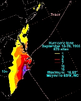
and the tides increased until 8:45 a.m. on September 19 before rapidly rising between 2:00 and 2:30 p.m. The Lake Causeway was partially washed out towards New Holland. The Diamond Shoals lightship was reported to have broken loose during the hurricane. Tides did not fully recede at Swan Quarter until 3 a.m. on September 20, with winds finally dying down after 7 a.m. the same day. Cherry Point recorded a maximum sustained wind of 75 miles per hour (120.7 km/h), with gusts to 107 miles per hour (172.2 km/h). Prolonged easterly winds forced the tide to increase to levels 3 foot (0.9144 m) to 10 feet (3 m) above normal, which resulted in one of the largest inundations in North Carolina history. The storm surge from Ione was recorded at 3.6 feet (1.1 m) at Morehead City, North Carolina, while a storm tide of 5.3 feet (1.6 m) was measured at Wrightsville Beach, North Carolina
. It was reported that the storm lasted for nearly two days in North Carolina.
HMTS Monarch, which had departed from Newfoundland, was laying telephone cable across the Atlantic ocean when Ione crossed its path. The ship weathered the storm, and managed to reach Scotland to complete its mission by September 26.
Ione caused $600 million (2005 USD) in damage, much of it to crops across North Carolina. The rest came from flooding in an area already devastated by Hurricanes Connie
and Diane
six weeks earlier. Along the Trent river near Trent
and the New River near Gum Branch, North Carolina, the river stage reached heights not seen again until Hurricane Floyd
of the 1999 Atlantic hurricane season
. Ione caused seven deaths in North Carolina, a low number attributed to well-executed warnings and effectiveness of relief groups such as the Red Cross.
Ione made landfall in Newfoundland , Canada during the evening of September 21 as a tropical storm and as a result cause wind and rain damage.That day the storm became extratropical, yet still had negative effects on Canada. In Carbonear a boy broke his leg after being blown into a car and thousands of dollars in damage, as well as broken polls, uprooted trees, interrupted telephone service, damaged chimneys and power outages were reported in St. John's, Canada. There were also reports of roof damage and a trailer being torn for its foundation. Three flights were cancelled, schools were closed and the ferry service between Bell Island
and Portugal Cove was disrupted. On September 23 there were reports of boats that had been lost and in Harbour Grace and Harbour Main. There was also a report of a garage being flipped with a car still in it. There were also reports of a street and two mines being flooded in Corner Brook and it was reported that there was $2 million damage to the province. There was extensive damage to waterfront property on the southern coast of Newfoundland. On September 24 there were reports of fishermen losing gear, a house being blown off its foundation in Foxtrap, damage to the phone company, a washed out road in Swift Current
and damage to the power company. On September 27 it was reported that buoys were destroyed in Harbour Grace, Fortune
and Stag Harbour
. There was also damage done to a freighter in Conception Bay.
When one of the first tropical cyclone forecast models was developed, Ione was chosen as one of the candidates to test out its reliability. The errors associated with Ione were significant, as the model did not forecast Ione to make landfall in North Carolina, forcing the storm eastward to the south of the state.
North Carolina
North Carolina is a state located in the southeastern United States. The state borders South Carolina and Georgia to the south, Tennessee to the west and Virginia to the north. North Carolina contains 100 counties. Its capital is Raleigh, and its largest city is Charlotte...
in September 1955, bringing high winds and significant rainfall. It came on the heels of Hurricanes Connie
Hurricane Connie
Hurricane Connie was the first in a series of hurricanes to strike North Carolina during the 1955 Atlantic hurricane season. Connie struck as a Category 1, causing major flooding and inflicting extensive damage to the Outer Banks and inland to Raleigh....
and Diane
Hurricane Diane
Hurricane Diane was one of three hurricanes to hit North Carolina during the 1955 Atlantic hurricane season, striking an area that had been hit by Hurricane Connie five days earlier...
, and compounded problems already caused by the two earlier hurricanes. Spawned by a tropical wave
Tropical wave
Tropical waves, easterly waves, or tropical easterly waves, also known as African easterly waves in the Atlantic region, are a type of atmospheric trough, an elongated area of relatively low air pressure, oriented north to south, which move from east to west across the tropics causing areas of...
which left the Africa
Africa
Africa is the world's second largest and second most populous continent, after Asia. At about 30.2 million km² including adjacent islands, it covers 6% of the Earth's total surface area and 20.4% of the total land area...
n coast on September 6, the system became a tropical depression in the tropical North Atlantic, before turning northwest and developing into a hurricane. After turning back to the west east of the Bahamas, Ione turned northwest and northward, moving across eastern North Carolina before moving east-northeastward out to sea. Ione caused $600 million (2005 USD) in damage, much of it to crops across North Carolina. As a result of Ione's impacts seven people lost their lives.
Meteorological history
A tropical wave moved through Cape VerdeCape Verde
The Republic of Cape Verde is an island country, spanning an archipelago of 10 islands located in the central Atlantic Ocean, 570 kilometres off the coast of Western Africa...
on September 6 and on September 11 Ione developed into a tropical depression. Ione remained weak for the next few days, and then began to steadily intensify as it moved north of the Lesser Antilles
Lesser Antilles
The Lesser Antilles are a long, partly volcanic island arc in the Western Hemisphere. Most of its islands form the eastern boundary of the Caribbean Sea with the Atlantic Ocean, with the remainder located in the southern Caribbean just north of South America...
, reaching hurricane strength on September 15. Conditions were favorable for additional development, and Ione peaked with winds of 120 miles per hour (193.1 km/h) on September 18 while north of the Bahamas.
Drier and cooler air gradually became entrained in Ione's circulation, and the storm weakened into a minimal hurricane at the time of its Wilmington, North Carolina
Wilmington, North Carolina
Wilmington is a port city in and is the county seat of New Hanover County, North Carolina, United States. The population is 106,476 according to the 2010 Census, making it the eighth most populous city in the state of North Carolina...
, landfall on September 19, which made Ione the third hurricane to hit the state in six weeks and fourth in 11 months. Ione was the first tropical cyclone to be observed on the Cape Hatteras radar during landfall and was one of the first observed to make small-scale oscillations within its track. The storm weakened to a tropical storm over land but restrengthened to a Category 2 hurricane over the northwestern Atlantic. Ione continued northeastward and became an extratropical cyclone
Extratropical cyclone
Extratropical cyclones, sometimes called mid-latitude cyclones or wave cyclones, are a group of cyclones defined as synoptic scale low pressure weather systems that occur in the middle latitudes of the Earth having neither tropical nor polar characteristics, and are connected with fronts and...
on September 21. The extratropical storm crossed over Newfoundland and was last seen on September 24 moving across the North Atlantic.
Preparations
Hurricane warnings were in effect from the Virginia Capes to Morehead, North Carolina and a Hurricane alert was issued northward to Atlantic City, New JerseyAtlantic City, New Jersey
Atlantic City is a city in Atlantic County, New Jersey, United States, and a nationally renowned resort city for gambling, shopping and fine dining. The city also served as the inspiration for the American version of the board game Monopoly. Atlantic City is located on Absecon Island on the coast...
. Dump trucks loaded with dirt were ready to make earthen dikes around the Riegel paper mill, due to the severe damage caused to it by hurricanes earlier that year which caused the 1955 Delaware river flood. Recent flooding, from Hurricane Diane
Hurricane Diane
Hurricane Diane was one of three hurricanes to hit North Carolina during the 1955 Atlantic hurricane season, striking an area that had been hit by Hurricane Connie five days earlier...
, along the Delaware River
Delaware River
The Delaware River is a major river on the Atlantic coast of the United States.A Dutch expedition led by Henry Hudson in 1609 first mapped the river. The river was christened the South River in the New Netherland colony that followed, in contrast to the North River, as the Hudson River was then...
kept residents along its banks alert should the storm strike, business owners were also ready to move their merchandise if the need arose. New York City
New York City
New York is the most populous city in the United States and the center of the New York Metropolitan Area, one of the most populous metropolitan areas in the world. New York exerts a significant impact upon global commerce, finance, media, art, fashion, research, technology, education, and...
officials prepared for the worst, with police officers filling gas tanks of their patrol cars and extra patrol men being called to duty in advance of the hurricane. Flights were canceled in New York, firemen stood at the ready in Staten Island, and the Coast Guard
United States Coast Guard
The United States Coast Guard is a branch of the United States Armed Forces and one of the seven U.S. uniformed services. The Coast Guard is a maritime, military, multi-mission service unique among the military branches for having a maritime law enforcement mission and a federal regulatory agency...
warned shipping companies of the impending storm. A boxing match between Rocky Marciano
Rocky Marciano
Rocky Marciano , born Rocco Francis Marchegiano, was an American boxer and the heavyweight champion of the world from September 23, 1952, to April 27, 1956. Marciano is the only champion to hold the heavyweight title and go undefeated throughout his career. Marciano defended his title six times...
and Archie Moore
Archie Moore
Archie Moore, born Archibald Lee Wright , was light heavyweight world boxing champion who had one of the longest professional careers in the history of that sport....
was delayed, which allowed the promoters to sell an additional $150,000 (1955) in tickets, which is $ in present day figures.
Impact
1953 Atlantic hurricane season
The 1953 Atlantic hurricane season was the first time an organized list of female names was used to name Atlantic storms. It officially began on June 15, and lasted until November 15, although activity occurred both before and after the season's limits...
and the tides increased until 8:45 a.m. on September 19 before rapidly rising between 2:00 and 2:30 p.m. The Lake Causeway was partially washed out towards New Holland. The Diamond Shoals lightship was reported to have broken loose during the hurricane. Tides did not fully recede at Swan Quarter until 3 a.m. on September 20, with winds finally dying down after 7 a.m. the same day. Cherry Point recorded a maximum sustained wind of 75 miles per hour (120.7 km/h), with gusts to 107 miles per hour (172.2 km/h). Prolonged easterly winds forced the tide to increase to levels 3 foot (0.9144 m) to 10 feet (3 m) above normal, which resulted in one of the largest inundations in North Carolina history. The storm surge from Ione was recorded at 3.6 feet (1.1 m) at Morehead City, North Carolina, while a storm tide of 5.3 feet (1.6 m) was measured at Wrightsville Beach, North Carolina
Wrightsville Beach, North Carolina
Wrightsville Beach is a town in New Hanover County, North Carolina, United States. Wrightsville Beach is just east of Wilmington and is part of the Wilmington Metropolitan Statistical Area. The population was 2,593 at the 2000 census...
. It was reported that the storm lasted for nearly two days in North Carolina.
HMTS Monarch, which had departed from Newfoundland, was laying telephone cable across the Atlantic ocean when Ione crossed its path. The ship weathered the storm, and managed to reach Scotland to complete its mission by September 26.
Ione caused $600 million (2005 USD) in damage, much of it to crops across North Carolina. The rest came from flooding in an area already devastated by Hurricanes Connie
Hurricane Connie
Hurricane Connie was the first in a series of hurricanes to strike North Carolina during the 1955 Atlantic hurricane season. Connie struck as a Category 1, causing major flooding and inflicting extensive damage to the Outer Banks and inland to Raleigh....
and Diane
Hurricane Diane
Hurricane Diane was one of three hurricanes to hit North Carolina during the 1955 Atlantic hurricane season, striking an area that had been hit by Hurricane Connie five days earlier...
six weeks earlier. Along the Trent river near Trent
Trent Woods, North Carolina
Trent Woods is a town in Craven County, North Carolina, United States. The population was estimated at 3,961 in 2005. It is part of the New Bern, North Carolina Micropolitan Statistical Area.-Geography:Trent Woods is located at ....
and the New River near Gum Branch, North Carolina, the river stage reached heights not seen again until Hurricane Floyd
Hurricane Floyd
Hurricane Floyd was the sixth named storm, fourth hurricane, and third major hurricane in the 1999 Atlantic hurricane season. Floyd triggered the third largest evacuation in US history when 2.6 million coastal residents of five states were ordered from their homes as it approached...
of the 1999 Atlantic hurricane season
1999 Atlantic hurricane season
The 1999 Atlantic hurricane season officially began on June 1, 1999, and lasted until November 30, 1999. These dates conventionally delimit the period of each year when most tropical cyclones form in the Atlantic basin....
. Ione caused seven deaths in North Carolina, a low number attributed to well-executed warnings and effectiveness of relief groups such as the Red Cross.
Ione made landfall in Newfoundland , Canada during the evening of September 21 as a tropical storm and as a result cause wind and rain damage.That day the storm became extratropical, yet still had negative effects on Canada. In Carbonear a boy broke his leg after being blown into a car and thousands of dollars in damage, as well as broken polls, uprooted trees, interrupted telephone service, damaged chimneys and power outages were reported in St. John's, Canada. There were also reports of roof damage and a trailer being torn for its foundation. Three flights were cancelled, schools were closed and the ferry service between Bell Island
Bell Island
Bell Island is a Canadian island located off Newfoundland's Avalon Peninsula in Conception Bay.Measuring 9 km in length and 3 km in width, Bell Island has an area of 34 km²...
and Portugal Cove was disrupted. On September 23 there were reports of boats that had been lost and in Harbour Grace and Harbour Main. There was also a report of a garage being flipped with a car still in it. There were also reports of a street and two mines being flooded in Corner Brook and it was reported that there was $2 million damage to the province. There was extensive damage to waterfront property on the southern coast of Newfoundland. On September 24 there were reports of fishermen losing gear, a house being blown off its foundation in Foxtrap, damage to the phone company, a washed out road in Swift Current
Swift Current, Newfoundland and Labrador
Swift Current is a settlement in Newfoundland and Labrador....
and damage to the power company. On September 27 it was reported that buoys were destroyed in Harbour Grace, Fortune
Fortune, Newfoundland and Labrador
Fortune is a Canadian town located in the province of Newfoundland and Labrador.Fortune is situated on the western side of the Burin Peninsula on the island of Newfoundland and was incorporated as a town in 1945. The town is located near the southeastern boundary of Fortune Bay...
and Stag Harbour
Stag Harbour, Newfoundland and Labrador
Stag Harbour, with a population of approximately 250, is a community on Fogo Island, in Newfoundland, Canada.-See also:* List of communities in Newfoundland and Labrador...
. There was also damage done to a freighter in Conception Bay.
Legacy
Due to the damage, the name Ione was retired and will never be used for an Atlantic hurricane again. This was before the formal lists were created, as a result it was not replaced with any particular name. As a result of this, this is the only time the name Ione was used for the Atlantic Basin since hurricane naming began in 1950.When one of the first tropical cyclone forecast models was developed, Ione was chosen as one of the candidates to test out its reliability. The errors associated with Ione were significant, as the model did not forecast Ione to make landfall in North Carolina, forcing the storm eastward to the south of the state.
See also
- List of Atlantic hurricanes
- List of wettest tropical cyclones in North Carolina
- List of North Carolina hurricanes