

Dauphin Island, Alabama
Encyclopedia
Dauphin Island is a town in Mobile County
, Alabama
(U.S.), on a barrier island
also named Dauphin Island (split by the Katrina Cut), at the Gulf of Mexico
. The population was 1,371 at the 2000 census. The town is included in the Mobile
metropolitan statistical area. The island (originally named "Massacre Island") was renamed for Louis XIV
's great-grandson and heir, the Dauphin.
The Gulf of Mexico is to the south of the island; the Mississippi Sound
and Mobile Bay
are to the north. The island's eastern end helps to define the mouth of Mobile Bay. The eastern, wider portion of the island, is shaded by thick stands of pine trees, but the narrow, western part of the island features scrub growth and few trees.
Dauphin Island is home to Fort Gaines, Dauphin Island Sea Lab
, The Estuarium public aquarium, the Dauphin Island Airport
, boat ramps, a large public pier, historics sites, several restaurants, new condominium developments, and numerous private homes. Beaches attract tourism, and fishing is a popular activity in the waters around the island. The island is connected to the mainland by the Gordon Persons Bridge.
Although the island has several bird sanctuaries, the main one is the 164 acres (66.4 ha) Audubon Bird Sanctuary. Dauphin Island is the first landfall encountered by many birds as they migrate
north from South America, and as a consequence many species can be found resting there before continuing their journey.
s, perhaps 1500 years old, attest to at least seasonal occupation by the Native American Mound Builder culture. Shell Mound Park, along the Island's northern shore, is administered by Alabama Marine Resources Division.
In 1519, the Spanish explorer Alonzo Pineda was the first documented European to visit, staying long enough to map the island with remarkable accuracy.
The island's French history began on January 31, 1699, when the explorer Pierre Le Moyne, sieur d'Iberville
, one of the founders of French Louisiana
, arrived at Mobile Bay, and anchored near the island on his way to explore the mouth of the Mississippi River
. D'Iberville named it "Isle Du Massacre" (Massacre Island) because of a large pile of human skeletons discovered there. The gruesome site turned out to be a simple burial mound which had been broken open by a hurricane, not a massacre site, but the name stuck.
D'Iberville later decided to locate a port for Fort Louis de La Louisiane
on the island due to abundant timber, reliable supply of fresh water, and a deep-water harbor. The settlement consisted of a fort, a chapel, government-owned warehouses, and residences.
The island served as a major trading depot
, unloading goods from Saint-Domingue
(Haiti), Mexico, Cuba and France, and collecting furs in a short-lived fur trade
. Mobile Bay itself, before a channel was dredged, was too shallow, and its sand bars too shifting and treacherous, for ocean-going vessels to travel up the bay and Mobile River
to Fort Louis de La Louisiane. So, smaller boats carried cargo within Mobile Bay to Dauphin Island.
Fort Gaines
on the eastern tip of the island was built between 1821 and 1848. It was occupied by Confederate forces in 1861, and captured by Federal troops during the Battle of Mobile Bay
. The phrase, "Damn the torpedoes, full speed ahead," was spoken by U. S. Admiral David Farragut
just a few hundred yards from Dauphin Island's shore.
The first Sand Island Light, authorized in 1834, was replaced by a structure 150 feet (45.7 m) high, at a cost of $35,000, that was dynamited by Confederate forces. The present lighthouse (1873; in use until 1970), has been placed on the National Register of Historic Places
. Its ownership was recently transferred from the Department of Interior to the Town of Dauphin Island.
of 2000, there were 1,371 people,(but falling in the 2010 census to 1238) 601 households, and 418 families residing in the town. The population density
was 221.2 people per square mile (85.4/km2). There were 1,691 housing units at an average density of 272.9 per square mile (105.3/km2). The racial makeup of the town was 96.43% White
, 0.44% Black
or African American
, 1.60% Native American
, 0.58% Asian
, and 0.95% from two or more races. Hispanic
or Latino
of any race were 0.95% of the population.
There were 601 households out of which 21.6% had children under the age of 18 living with them, 61.7% were married couples
living together, 5.0% had a female householder with no husband present, and 30.3% were non-families. 23.0% of all households were made up of individuals and 6.3% had someone living alone who was 65 years of age or older. The average household size was 2.28 and the average family size was 2.66.
In the town the population was spread out with 17.4% under the age of 18, 7.4% from 18 to 24, 25.7% from 25 to 44, 33.3% from 45 to 64, and 16.2% who were 65 years of age or older. The median age was 45 years. For every 100 females there were 111.6 males. For every 100 females age 18 and over, there were 114.0 males.
The median income for a household in the town was $44,219, and the median income for a family was $50,476. Males had a median income of $35,179 versus $24,250 for females. The per capita income
for the town was $22,552. About 6.0% of families and 9.2% of the population were below the poverty line, including 6.7% of those under age 18 and 5.4% of those age 65 or over.
. It has one public school, Dauphin Island Elementary School. Middle school students go on to Alba Middle School in Bayou La Batre
and Alma Bryant High School
in the Irvington section of unincorporated Mobile County.
The Dauphin Island Sea Lab
is located on the east end of the island on grounds formerly occupied by the 693rd Radar Squadron, Dauphin Island Air Force Station, US Air Force
, and is home to the Marine Environmental Sciences Consortium.
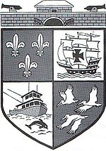 On the top is the historic Ft Gaines with two cannons (one facing North and one facing South) which represents Dauphin Island's part in America's Civil War of the 1800s. The boat is a shrimping vessel which represents the livelihood of many of the residents of the island and the Dolphin is a mammal seen quite often in the Gulf of Mexico and Mobile bay waters surrounding the Island. The birds are Pelicans which are numerous around the island and the entire Gulf coast. The Fleur de Lis represents France (1699–1764). The sailing ship is a Spanish Galleon (1781–1813). Both countries were very influential in settling the area.
The approach road to the island fared better than expected. The damage to most East End beach front homes was limited to decks, stairs and storage buildings. In DeSoto Landing, a gated gulf-front subdivision on Dauphin Island, the main homes had no water entering the homes unless a window or roof system failed; many avoided surge waters entirely. Damage was limited due to Sand Island (Pelican Island), a large sandbar south of DeSoto Landing which broke the force of battering waves.
An oil drilling platform grounded near the island as the hurricane passed by. It was identified by its owners, Diamond Offshore Drilling Inc., as the Ocean Warwick, pushed nearly 60 miles (96.6 km) from its original location by the hurricane.
brings both vehicles and pedestrians to the island. One of the closest attractions to the ferry dock is The Estuarium, a fresh- and saltwater aquarium highlighting species native to Alabama.
Mobile County, Alabama
Mobile County[p] is a county of the U.S. state of Alabama. Its name is in honor of a tribe of Indians, the Maubila tribe . As of 2011, its population was 415,704. Its county seat is Mobile, Alabama...
, Alabama
Alabama
Alabama is a state located in the southeastern region of the United States. It is bordered by Tennessee to the north, Georgia to the east, Florida and the Gulf of Mexico to the south, and Mississippi to the west. Alabama ranks 30th in total land area and ranks second in the size of its inland...
(U.S.), on a barrier island
Barrier island
Barrier islands, a coastal landform and a type of barrier system, are relatively narrow strips of sand that parallel the mainland coast. They usually occur in chains, consisting of anything from a few islands to more than a dozen...
also named Dauphin Island (split by the Katrina Cut), at the Gulf of Mexico
Gulf of Mexico
The Gulf of Mexico is a partially landlocked ocean basin largely surrounded by the North American continent and the island of Cuba. It is bounded on the northeast, north and northwest by the Gulf Coast of the United States, on the southwest and south by Mexico, and on the southeast by Cuba. In...
. The population was 1,371 at the 2000 census. The town is included in the Mobile
Mobile, Alabama
Mobile is the third most populous city in the Southern US state of Alabama and is the county seat of Mobile County. It is located on the Mobile River and the central Gulf Coast of the United States. The population within the city limits was 195,111 during the 2010 census. It is the largest...
metropolitan statistical area. The island (originally named "Massacre Island") was renamed for Louis XIV
Louis XIV of France
Louis XIV , known as Louis the Great or the Sun King , was a Bourbon monarch who ruled as King of France and Navarre. His reign, from 1643 to his death in 1715, began at the age of four and lasted seventy-two years, three months, and eighteen days...
's great-grandson and heir, the Dauphin.
The Gulf of Mexico is to the south of the island; the Mississippi Sound
Mississippi Sound
The Mississippi Sound is a sound along the Gulf Coast of the United States. It runs east-west along the southern coasts of Mississippi and Alabama, from Waveland, Mississippi, to the Dauphin Island Bridge, a distance of about 145 kilometers...
and Mobile Bay
Mobile Bay
Mobile Bay is an inlet of the Gulf of Mexico, lying within the state of Alabama in the United States. Its mouth is formed by the Fort Morgan Peninsula on the eastern side and Dauphin Island, a barrier island on the western side. The Mobile River and Tensaw River empty into the northern end of the...
are to the north. The island's eastern end helps to define the mouth of Mobile Bay. The eastern, wider portion of the island, is shaded by thick stands of pine trees, but the narrow, western part of the island features scrub growth and few trees.
Dauphin Island is home to Fort Gaines, Dauphin Island Sea Lab
Dauphin Island Sea Lab
The Dauphin Island Sea Lab is Alabama's primary marine education and research center. DISL is the home site of the Marine Environmental Sciences Consortium and was founded by an act of the Alabama State Legislature in 1971. It also has a public aquarium specializing in estuarine organisms, the...
, The Estuarium public aquarium, the Dauphin Island Airport
Dauphin Island Airport
Dauphin Island Airport is a county-owned public-use airport in Mobile County, Alabama, United States. It is just northwest of the central business district of Dauphin Island, a town located on a barrier island...
, boat ramps, a large public pier, historics sites, several restaurants, new condominium developments, and numerous private homes. Beaches attract tourism, and fishing is a popular activity in the waters around the island. The island is connected to the mainland by the Gordon Persons Bridge.
Although the island has several bird sanctuaries, the main one is the 164 acres (66.4 ha) Audubon Bird Sanctuary. Dauphin Island is the first landfall encountered by many birds as they migrate
Bird migration
Bird migration is the regular seasonal journey undertaken by many species of birds. Bird movements include those made in response to changes in food availability, habitat or weather. Sometimes, journeys are not termed "true migration" because they are irregular or in only one direction...
north from South America, and as a consequence many species can be found resting there before continuing their journey.
History
Serpentine shell middenMidden
A midden, is an old dump for domestic waste which may consist of animal bone, human excrement, botanical material, vermin, shells, sherds, lithics , and other artifacts and ecofacts associated with past human occupation...
s, perhaps 1500 years old, attest to at least seasonal occupation by the Native American Mound Builder culture. Shell Mound Park, along the Island's northern shore, is administered by Alabama Marine Resources Division.
In 1519, the Spanish explorer Alonzo Pineda was the first documented European to visit, staying long enough to map the island with remarkable accuracy.
The island's French history began on January 31, 1699, when the explorer Pierre Le Moyne, sieur d'Iberville
Pierre Le Moyne d'Iberville
Pierre Le Moyne d'Iberville pronounced as described in note] Pierre Le Moyne d'Iberville pronounced as described in note] Pierre Le Moyne d'Iberville pronounced as described in note] (16 July 1661 – 9 July 1702 (probable)was a soldier, ship captain, explorer, colonial administrator, knight of...
, one of the founders of French Louisiana
Louisiana (New France)
Louisiana or French Louisiana was an administrative district of New France. Under French control from 1682–1763 and 1800–03, the area was named in honor of Louis XIV, by French explorer René-Robert Cavelier, Sieur de la Salle...
, arrived at Mobile Bay, and anchored near the island on his way to explore the mouth of the Mississippi River
Mississippi River
The Mississippi River is the largest river system in North America. Flowing entirely in the United States, this river rises in western Minnesota and meanders slowly southwards for to the Mississippi River Delta at the Gulf of Mexico. With its many tributaries, the Mississippi's watershed drains...
. D'Iberville named it "Isle Du Massacre" (Massacre Island) because of a large pile of human skeletons discovered there. The gruesome site turned out to be a simple burial mound which had been broken open by a hurricane, not a massacre site, but the name stuck.
D'Iberville later decided to locate a port for Fort Louis de La Louisiane
Old Mobile Site
The Old Mobile Site was the location of the French settlement La Mobile and the associated Fort Louis de La Louisiane, in the French colony of New France in North America, from 1702 until 1712. The site is located in Le Moyne, Alabama, on the Mobile River in the Mobile-Tensaw River Delta...
on the island due to abundant timber, reliable supply of fresh water, and a deep-water harbor. The settlement consisted of a fort, a chapel, government-owned warehouses, and residences.
The island served as a major trading depot
Distribution center
A distribution center for a set of products is a warehouse or other specialized building, often with refrigeration or air conditioning, which is stocked with products to be redistributed to retailers, to wholesalers, or directly to consumers. A distribution center is a principal part, the order...
, unloading goods from Saint-Domingue
Saint-Domingue
The labour for these plantations was provided by an estimated 790,000 African slaves . Between 1764 and 1771, the average annual importation of slaves varied between 10,000-15,000; by 1786 it was about 28,000, and from 1787 onward, the colony received more than 40,000 slaves a year...
(Haiti), Mexico, Cuba and France, and collecting furs in a short-lived fur trade
Fur trade
The fur trade is a worldwide industry dealing in the acquisition and sale of animal fur. Since the establishment of world market for in the early modern period furs of boreal, polar and cold temperate mammalian animals have been the most valued...
. Mobile Bay itself, before a channel was dredged, was too shallow, and its sand bars too shifting and treacherous, for ocean-going vessels to travel up the bay and Mobile River
Mobile River
The Mobile River is located in southern Alabama in the United States. Formed out of the confluence of the Tombigbee and Alabama rivers, the approximately river drains an area of of Alabama, with a watershed extending into Mississippi, Georgia, and Tennessee. Its drainage basin is the...
to Fort Louis de La Louisiane. So, smaller boats carried cargo within Mobile Bay to Dauphin Island.
Fort Gaines
Fort Gaines, Alabama
Fort Gaines is a historic fort on Dauphin Island, Alabama, United States. It was named for Edmund Pendleton Gaines. Established in 1821, it is best known for its role in the Battle of Mobile Bay during the American Civil War....
on the eastern tip of the island was built between 1821 and 1848. It was occupied by Confederate forces in 1861, and captured by Federal troops during the Battle of Mobile Bay
Battle of Mobile Bay
The Battle of Mobile Bay of August 5, 1864, was an engagement of the American Civil War in which a Federal fleet commanded by Rear Adm. David G. Farragut, assisted by a contingent of soldiers, attacked a smaller Confederate fleet led by Adm...
. The phrase, "Damn the torpedoes, full speed ahead," was spoken by U. S. Admiral David Farragut
David Farragut
David Glasgow Farragut was a flag officer of the United States Navy during the American Civil War. He was the first rear admiral, vice admiral, and admiral in the United States Navy. He is remembered in popular culture for his order at the Battle of Mobile Bay, usually paraphrased: "Damn the...
just a few hundred yards from Dauphin Island's shore.
The first Sand Island Light, authorized in 1834, was replaced by a structure 150 feet (45.7 m) high, at a cost of $35,000, that was dynamited by Confederate forces. The present lighthouse (1873; in use until 1970), has been placed on the National Register of Historic Places
National Register of Historic Places
The National Register of Historic Places is the United States government's official list of districts, sites, buildings, structures, and objects deemed worthy of preservation...
. Its ownership was recently transferred from the Department of Interior to the Town of Dauphin Island.
Geography
According to the U.S. Census Bureau, the town has a total area of 166.1 square miles (430.1 km2), of which, 6.2 square miles (16.1 km2) of it is land and 159.9 square miles (414.1 km2) of it (96.27%) is water.Demographics
As of the censusCensus
A census is the procedure of systematically acquiring and recording information about the members of a given population. It is a regularly occurring and official count of a particular population. The term is used mostly in connection with national population and housing censuses; other common...
of 2000, there were 1,371 people,(but falling in the 2010 census to 1238) 601 households, and 418 families residing in the town. The population density
Population density
Population density is a measurement of population per unit area or unit volume. It is frequently applied to living organisms, and particularly to humans...
was 221.2 people per square mile (85.4/km2). There were 1,691 housing units at an average density of 272.9 per square mile (105.3/km2). The racial makeup of the town was 96.43% White
Race (United States Census)
Race and ethnicity in the United States Census, as defined by the Federal Office of Management and Budget and the United States Census Bureau, are self-identification data items in which residents choose the race or races with which they most closely identify, and indicate whether or not they are...
, 0.44% Black
Race (United States Census)
Race and ethnicity in the United States Census, as defined by the Federal Office of Management and Budget and the United States Census Bureau, are self-identification data items in which residents choose the race or races with which they most closely identify, and indicate whether or not they are...
or African American
Race (United States Census)
Race and ethnicity in the United States Census, as defined by the Federal Office of Management and Budget and the United States Census Bureau, are self-identification data items in which residents choose the race or races with which they most closely identify, and indicate whether or not they are...
, 1.60% Native American
Race (United States Census)
Race and ethnicity in the United States Census, as defined by the Federal Office of Management and Budget and the United States Census Bureau, are self-identification data items in which residents choose the race or races with which they most closely identify, and indicate whether or not they are...
, 0.58% Asian
Race (United States Census)
Race and ethnicity in the United States Census, as defined by the Federal Office of Management and Budget and the United States Census Bureau, are self-identification data items in which residents choose the race or races with which they most closely identify, and indicate whether or not they are...
, and 0.95% from two or more races. Hispanic
Race (United States Census)
Race and ethnicity in the United States Census, as defined by the Federal Office of Management and Budget and the United States Census Bureau, are self-identification data items in which residents choose the race or races with which they most closely identify, and indicate whether or not they are...
or Latino
Race (United States Census)
Race and ethnicity in the United States Census, as defined by the Federal Office of Management and Budget and the United States Census Bureau, are self-identification data items in which residents choose the race or races with which they most closely identify, and indicate whether or not they are...
of any race were 0.95% of the population.
There were 601 households out of which 21.6% had children under the age of 18 living with them, 61.7% were married couples
Marriage
Marriage is a social union or legal contract between people that creates kinship. It is an institution in which interpersonal relationships, usually intimate and sexual, are acknowledged in a variety of ways, depending on the culture or subculture in which it is found...
living together, 5.0% had a female householder with no husband present, and 30.3% were non-families. 23.0% of all households were made up of individuals and 6.3% had someone living alone who was 65 years of age or older. The average household size was 2.28 and the average family size was 2.66.
In the town the population was spread out with 17.4% under the age of 18, 7.4% from 18 to 24, 25.7% from 25 to 44, 33.3% from 45 to 64, and 16.2% who were 65 years of age or older. The median age was 45 years. For every 100 females there were 111.6 males. For every 100 females age 18 and over, there were 114.0 males.
The median income for a household in the town was $44,219, and the median income for a family was $50,476. Males had a median income of $35,179 versus $24,250 for females. The per capita income
Per capita income
Per capita income or income per person is a measure of mean income within an economic aggregate, such as a country or city. It is calculated by taking a measure of all sources of income in the aggregate and dividing it by the total population...
for the town was $22,552. About 6.0% of families and 9.2% of the population were below the poverty line, including 6.7% of those under age 18 and 5.4% of those age 65 or over.
Education
The town is served by the Mobile County Public School SystemMobile County Public School System
Mobile County Public School System is a school district based in the Mobile County Public Schools Central Office Campus in an unincorporated area in Mobile County, Alabama United States....
. It has one public school, Dauphin Island Elementary School. Middle school students go on to Alba Middle School in Bayou La Batre
Bayou La Batre, Alabama
Bayou La Batre is a town in Mobile County, Alabama, United States. It is included in the Mobile metropolitan statistical area. At the 2000 census, the population was 2,313. According to the 2005 U.S. Census estimates, the city had a population of 2,725....
and Alma Bryant High School
Alma Bryant High School
Alma Bryant High School is an Alabama high school located in Irvington, Alabama, United States on State Highway 188, midway between Grand Bay, Alabama and Bayou La Batre, Alabama. The school was formed in 1998 by combining Alba High School and Mobile County High School . The school was named for...
in the Irvington section of unincorporated Mobile County.
The Dauphin Island Sea Lab
Dauphin Island Sea Lab
The Dauphin Island Sea Lab is Alabama's primary marine education and research center. DISL is the home site of the Marine Environmental Sciences Consortium and was founded by an act of the Alabama State Legislature in 1971. It also has a public aquarium specializing in estuarine organisms, the...
is located on the east end of the island on grounds formerly occupied by the 693rd Radar Squadron, Dauphin Island Air Force Station, US Air Force
United States Air Force
The United States Air Force is the aerial warfare service branch of the United States Armed Forces and one of the American uniformed services. Initially part of the United States Army, the USAF was formed as a separate branch of the military on September 18, 1947 under the National Security Act of...
, and is home to the Marine Environmental Sciences Consortium.
Dauphin Island's Crest
Hurricanes
Over the centuries, many hurricanes have struck the island. Some recent storms include:- In 1979, Hurricane FredericHurricane FredericHurricane Frederic was the sixth tropical cyclone, third hurricane and second major hurricane of the 1979 Atlantic hurricane season. Frederic was the costliest hurricane to ever hit the U.S. Gulf Coast at that particular time...
(September 12, 1979) destroyed the bridge to the mainland, which had been opened in 1955. - In 1985, Hurricane ElenaHurricane ElenaHurricane Elena was a category 3 major hurricane that produced heavy damage along the Gulf Coast of the United States in August and September of the 1985 Atlantic hurricane season. The fifth tropical storm, fourth hurricane, and first major hurricane of the season, Elena developed near Cuba from a...
brought wind gusts of over 130 mph (209.2 km/h) to the island. - In 1997, Hurricane DannyHurricane DannyThe name Danny has been used for five tropical cyclones in the Atlantic Ocean. The name replaced David which was retired after the 1979 season:* Hurricane Danny - caused widespread flooding in Louisiana, killing 3 and causing $12 million in damage....
caused extensive flooding on the east end of the island. - In 1998, Hurricane GeorgesHurricane GeorgesHurricane Georges was a very destructive, powerful and long-lived Cape Verde-type Category 4 hurricane. Georges was the seventh tropical storm, fourth hurricane, and second major hurricane of the 1998 Atlantic hurricane season...
destroyed 41 houses on the island. - In 2004, Hurricane IvanHurricane IvanHurricane Ivan was a large, long-lived, Cape Verde-type hurricane that caused widespread damage in the Caribbean and United States. The cyclone was the ninth named storm, the sixth hurricane and the fourth major hurricane of the active 2004 Atlantic hurricane season...
caused nearly one-fourth of the island to be covered with approximately two feet of water. - On August 29, 2005, Hurricane KatrinaHurricane KatrinaHurricane Katrina of the 2005 Atlantic hurricane season was a powerful Atlantic hurricane. It is the costliest natural disaster, as well as one of the five deadliest hurricanes, in the history of the United States. Among recorded Atlantic hurricanes, it was the sixth strongest overall...
brought damage to parts of Dauphin Island. Some homes on the west end of the island were destroyed, and the Katrina Cut was formed as a channel splitting off the western part. However, most areas of the Central and East end of the island experienced little flooding from the storm surgeStorm surgeA storm surge is an offshore rise of water associated with a low pressure weather system, typically tropical cyclones and strong extratropical cyclones. Storm surges are caused primarily by high winds pushing on the ocean's surface. The wind causes the water to pile up higher than the ordinary sea...
. Unlike typical storm surge effects on a mainland coastline and affected waterways, on an island the surge moves around and over the land mass without the mounding up of water experienced on the mainland.
The approach road to the island fared better than expected. The damage to most East End beach front homes was limited to decks, stairs and storage buildings. In DeSoto Landing, a gated gulf-front subdivision on Dauphin Island, the main homes had no water entering the homes unless a window or roof system failed; many avoided surge waters entirely. Damage was limited due to Sand Island (Pelican Island), a large sandbar south of DeSoto Landing which broke the force of battering waves.
An oil drilling platform grounded near the island as the hurricane passed by. It was identified by its owners, Diamond Offshore Drilling Inc., as the Ocean Warwick, pushed nearly 60 miles (96.6 km) from its original location by the hurricane.
Tourist attractions
The old walled Fort Gaines is on the east end of Dauphin Island. A ferry from nearby Fort Morgan in Gulf ShoresGulf Shores, Alabama
-External links:*...
brings both vehicles and pedestrians to the island. One of the closest attractions to the ferry dock is The Estuarium, a fresh- and saltwater aquarium highlighting species native to Alabama.
External links
- Town of Dauphin Island, official website
- Dauphin Island Property Owners Association
- Island Mullet Wrapper - Dauphin Island news and information
- Dauphin Island news and information
- Still in Harm's Way, NOW on PBS, Video on Dauphin Island
- Dauphin Island Park and Beach Board Dauphin Island, Alabama
- Dauphin Island Foundation
- Historic Fort Gaines on Dauphin Island, Alabama