
Hurricane Frances
Encyclopedia
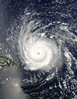
Hurricane Frances was the sixth named storm
, the fourth hurricane
, and the third major hurricane of the 2004 Atlantic hurricane season
. The system crossing the open Atlantic during mid to late August, moving to the north of the Lesser Antilles while strengthening. Its outer bands affected Puerto Rico
and the British Virgin Islands
while passing north of the Caribbean sea
. The storm's maximum sustained wind
speeds peaked at 145 miles per hour (233.4 km/h), achieving Category 4 on the Saffir-Simpson Hurricane Scale
. As the system slowed down its forward motion, the eye
passed over San Salvador Island
and very close to Cat Island in the Bahamas. Frances was the first hurricane to impact the entire Bahamian archipelago since 1866, and led to the nearly complete destruction of their agricultural economy.
Frances then passed over the central sections of the state of Florida
in the U.S.
only three weeks after Hurricane Charley
, causing significant damage to the state's citrus crop, closing schools and canceling a football game. The storm then moved briefly offshore Florida into the northeast Gulf of Mexico
and made a second U.S. landfall at the Florida Panhandle
before accelerating northeast through the eastern United States
near the Appalachians into Atlantic Canada
while weakening. A significant tornado outbreak accompanied the storm across the eastern United States, nearly equaling the outbreak from Hurricane Beulah
. Very heavy rains fell in association with this slow moving and relatively large hurricane, which led to floods in Florida and North Carolina. A total of 49 lives were lost from the cyclone
. Damages totaled US$12 billion (2004 dollars).
on August 21. Moving under the base of the subtropical ridge
, it moved westward for several days, remaining disorganized despite favorable conditions. Thunderstorms associated with the wave finally began organizing early on August 24, and the system became a tropical depression
that evening. Good upper-level outflow was observed in all but the eastern quadrants as the depression continued on its path, and the depression strengthened to tropical storm status on August 25, approximately 1420 miles (2,285.3 km) east of the Lesser Antilles
.
The tropical storm, now named Frances, further intensified on August 26 in an environment of low vertical wind shear
as its track bent to the west-northwest. Frances rapidly intensified, developing an eye
and reaching hurricane strength late that afternoon. An approaching upper level trough caused Frances to move more northwesterly on August 27. The cyclone reached its primary peak intensity of 135 mi/h on August 28. The hurricane turned back to its original westward motion on August 29, as the upper trough moved away the region and the subtropical ridge strengthened to Frances' north.
 Over the next day, the hurricane underwent an eyewall replacement cycle
, during which the maximum sustained winds decreased to 115 mi/h. This weakening trend was short lived, and the storm reintensified during the afternoon of August 30, as vertical wind shear remained low. The storm continued strengthening as it turned west-northwestward, reaching its peak intensity of 145 mi/h on September 2 while 555 miles (893.2 km) east-southeast of West Palm Beach, Florida
. On September 2, Frances entered the Bahamas, passing directly over San Salvador Island
and very close to Cat Island. The storm weakened to a Category 3 hurricane by 2 pm, which was initially attributed to inner core processes, but increasing westerly winds aloft, and the resultant vertical wind shear, was later determined to be the cause. On September 3, Frances passed into the vicinity of Abaco Island
and directly over Grand Bahama
while continuing to slowly weaken. The storm regained Category 2 hurricane intensity prior to passing over Grand Bahama Island and also slowed in forward speed due to a weakness in the subtropical ridge to its north. Parts of South Florida began to be affected by squalls and the outer rainband
s of the hurricane at this time. Gusts from 40 miles per hour (64.4 km/h) to as high as 87 miles per hour (140 km/h) were reported from Jupiter Inlet to Miami.
Frances moved slowly, between 5 miles per hour (8 km/h) to 10 miles per hour (16.1 km/h), as it crossed the warm Gulf Stream
between the Bahamas and Florida, leading to the concern that it could restrengthen. However, Frances remained stable at Category 2 intensity with 105 miles per hour (169 km/h) maximum sustained wind
s while it battered the east coast of Florida between Fort Pierce
and West Palm Beach
for much of September 4. At 11 pm, the western edge of Frances' eyewall began moving onshore. Because of Frances' large eye, which was roughly 80 miles (128.7 km) across, and its slow forward motion, the center of circulation remained offshore for several more hours. At 1 am EDT on September 5 (0500 UTC), the center of the broad eye of Frances made landfall
along the Florida coast, at the southern end of Hutchinson Island, near Sewall's Point
, Jensen Beach
and Port Salerno, Florida
. Late on September 5, Frances picked up speed due to a strengthening high pressure system to its north and crossed the Florida Peninsula
, emerging over the Gulf of Mexico
near Tampa
as a tropical storm. After a short trip over the Gulf of Mexico, Frances made a second landfall near St. Marks, Florida
. Frances headed inland, weakening to a tropical depression and causing heavy rainfall over the southern and eastern United States. As Tropical Depression Frances turned northeast, United States
meteorologists at the Hydrometeorological Prediction Center
continued issuing advisories on the system until it crossed the Canadian
border into Quebec
, where heavy rainfall also fell.

, the northern United States Virgin Islands
, Culebra
, and Vieques. On the morning of August 30, the hurricane watch for Vieques was downgraded to a tropical storm watch. That afternoon, hurricane watches were changed to tropical storm warnings across Puerto Rico, Culebra, Vieques, British Virgin Islands, and the northern U. S. Virgin Islands while a tropical storm watch was issued for St. Croix while all remaining hurricane watches were dropped. That night, tropical storm watches were issued for eastern portions of the northern coast of the Dominican Republic while a tropical storm warning was issued for Guadeloupe.
Early on the morning of August 31, tropical storm warnings were dropped for Antigua, Barbuda, Nevis, and St. Kitts while hurricane watches were issued for the southeast Bahamas as well as the Turks and Caicos Islands. Hurricane watches were upgraded to hurricane warnings later that morning. Toward noon, tropical storm warnings were issued for the remainder of the northern coast of the Dominican Republic, a hurricane watch was issued for the central Bahamas, while all watches and warnings were dropped for northeast portion of the Dominican Republic and portions of the Lesser Antilles south of the British Virgin Islands. That afternoon, tropical storm warnings were dropped from Puerto Rico eastward. On the morning of September 1, a hurricane watch was issued for the northwest Bahamas while the watch for the central Bahamas was upgraded to a warning. That afternoon, warnings were dropped for the Dominican Republic.
On the evening of September 1, hurricane warnings were issued for the northwest Bahamas while hurricane watches were issued for the lower east coast of Florida and tropical storm watches were issued for the Florida Keys. There was the potential for catastrophic damage along Florida's heavily-populated east coast, with warnings that damages from Frances could exceed the insured losses of Hurricane Andrew
. These damage estimates were in anticipation that Frances would strike Florida as a strong Category Four hurricane. Preparations for the storm were stepped up in Florida on September 1. Governor Jeb Bush
declared a state of emergency
, Kennedy Space Center closed down, and evacuations of 500,000 people were initially ordered. Eventually 41 counties received evacuation orders, covering 2.8 million residents, the largest evacuation in Florida's history. The state education system also responded to the pending crisis. Many universities across Florida canceled classes. Both the University of Central Florida
and the University of North Florida
told all students to leave their dorms. Evacuation at the University of South Florida
was performed on a dorm-by-dorm basis. Florida Atlantic University
was closed for a week and a half. Most schools were shut down from southern Miami-Dade County to just south of Melbourne
two days before the hurricane. The annual Florida State University
-University of Miami
college football game was rescheduled for the following week.
 Early during the morning of September 2, hurricane watches were extended southward to Craig Key. Later that morning, hurricane watches were upgraded to hurricane warnings for the lower east coast of Florida while a hurricane watch and tropical storm warning was raised for most of the Florida Keys and Florida Bay. Hurricane warnings were dropped for the Turks and Caicos Islands late on the morning of September 1 and for the Southeast Bahamas late that night. Late on the morning of September 3, hurricane watches were issued for the northeast coast of Florida, while early that afternoon tropical storm warnings were issued for the same area. Hurricane warnings were dropped for the central Bahamas that afternoon. That night, tropical storm warnings were issued for the southwest coast of the Florida peninsula with watches issued for the northwest Florida peninsula. On the morning of September 4, tropical storm warnings were extended northward to Anna Maria Island and along the Georgia coast. Tropical storm watches were extended northward to St. Marks. That afternoon, hurricane watches were dropped for most of the northwest Bahamas while warnings were extended up the coast to St. Marks, Florida
, and watches were extended westward to Panama City, Florida
.
Early on morning of September 5, hurricane warnings were downgraded to tropical storm warnings south of Deerfield Beach, Florida
while tropical storm warnings were extended westward through the western Florida Keys. Later that morning, hurricane warnings were issued for most of the northwest Florida coast while hurricane watches were lowered for northeast Florida and hurricane warnings were dropped for the remainder of the northwest Bahamas. That afternoon, all warnings were dropped for southeast Florida south of Jupiter Inlet, while the remaining hurricane warnings along the east Florida coast were downgraded to tropical storm warnings. Hurricane warnings along the coast of western Florida were extended southward to Anna Maria Island. Late that night, tropical storm warnings were dropped south of Bonita Beach including all the Florida Keys. Early on the morning of September 6, all warnings were dropped in Florida south of Englewood and Cocoa Beach. Later that morning, hurricane warnings were downgraded to tropical storm warnings between Indian Pass and Destin as well as between Anna Maria Island and the Suwannee River
while all remaining warnings were dropped south of Anna Maria Island, as well as the Florida east coast and the Georgia coast. That afternoon, all hurricane warnings were downgraded to tropical storm warnings, with all warnings dropped between west of St. Marks and south of the Suwannee river. On the night of September 6, all remaining tropical cyclone warnings were dropped.
 The economic effect was felt early, as the storm struck during Labor Day
weekend, traditionally the final summer vacation weekend in the United States
. Many hotel reservations from South Carolina
to Florida
were cancelled as people, seeing the destruction caused weeks earlier by Hurricane Charley, decided to avoid the coastal areas for safety. One death in the Bahamas, one in Ohio
, and five in Florida were directly attributed to the storm. 42 more deaths - 32 in Florida, eight in Georgia
, one in the Bahamas and one in Ohio, are indirectly attributed to Frances.
The total civilian damage from Frances was determined to be approximately US$8,830,000,000 (2004 dollars). Add in the estimated US$100 million damage (2004 dollars) done to space and military facilities at Cape Canaveral, Florida
and the total damage was estimated to be about US$9 billion (2004 dollars), making it the fourth costliest hurricane in United States history at that time, behind Hurricane Andrew
of 1992 and Hurricanes Charley
and Ivan
of 2004. At the time, adjusted for inflation, it became the seventh costliest hurricane for the lower 48 United States
.
island experienced damage, primarily from snapping, though some browning from salt spray was noted. Several feet of water flooded the international airport at Freeport
.
In the Bahamas, insurers and reinsurers estimated industry insured losses at about $300 million (2004 dollars). All cool-season vegetable plantings, and the entire banana crop, were lost during Frances. The pineapple crop was significantly impacted by wind damage in Eleuthera
, while the entire fruit crop was lost for similar reasons. The corn crop in Long Island
and Cat Island
was completely lost. Significant poultry losses were experienced. Like with other hurricane-induced damage, to get the total damage in the area, the insured damage is multiplied by a factor of 2, which comes out to $600 million (2004 dollars).
 Near the point of its first landfall, few structures were destroyed and ocean overwash across the barrier island was limited, though the extent of the damage far exceeded that of Hurricane Charley. Wind damage to citrus groves led to a near total loss near the coast of east-central Florida between West Palm Beach and Melbourne, with lesser damage farther to the west across the Kissimmee River
basin. Between Hurricane Charley and Frances, citrus losses totaled $2 billion (2004 dollars). Significant tree damage was reported within golf courses along the Treasure Coast
, with an average of 300-500 trees experiencing damage per course.
Some areas of Florida received over 13 inches (330.2 mm) of rain as the system moved slowly through the state. Heavy rains caused a large sinkhole
to develop on Interstate 95
in Palm Beach County, which closed the highway to traffic. Similar to Hurricane Charley
earlier in the month, the Florida citrus
crops took large amounts of damage. Frances caused heavy damage to the large Vehicle Assembly Building
at the Kennedy Space Center
, ripping off over a thousand 4-by-10 foot aluminum panels used to clad the building. While Charley caused $700,000 damage (2004 dollars), Frances damage was significantly greater. Two external fuel tanks for the space shuttle
were in the building but seem undamaged. The Space Shuttle Discovery
's hangar was without power. The total damage to space and military facilities around Cape Canaveral, Florida
was reported at about $100 million (2004 dollars). Orlando, Florida
's theme parks closed Sunday — only the third time Walt Disney World closed for a hurricane, but the second time in a month.
, and North
and South Carolina
. The passage of tropical depression Frances into Georgia dumped up to 5 inches (127 mm) of rain onto the state and caused the closings of schools in 56 counties. Across Georgia, winds of 30 miles per hour (48.3 km/h) to 40 miles per hour (64.4 km/h), with gusts to 50 miles per hour (80.5 km/h) led to the downing of tree branches and power lines. At one point on September 7, a total of 380,000 residences were without power. Significant crop damage was seen, particularly to the cotton and the peanut crops. On average, 30 percent of the crops were lost during Frances.
. A strip of upslope-induced rainfall along the Blue Ridge escarpment produced as much as 23 inches (584.2 mm) of rain in some areas of western North Carolina as the warm tropical air surged up and over the mountains. The flooding from this along the Swannanoa River
near Asheville, North Carolina
caused a major break in the Asheville's water distribution system, leaving the city without water for several days. Significant crop damage was seen into North Carolina, which reported $55 million in crop damage. Frances also spawned 101 tornado
es from Florida
to as far north as Virginia
, shy of the single storm tornado record set during Hurricane Beulah
.
Power outages affected up to six million people. Over 20 airports closed during the storm.
, Frances passed through southern Ontario
. The storm dropped up to 5.39 inches (136.9 mm), washing out roads and causing localized flooding in Quebec
, New Brunswick
, and Newfoundland
. This rainfall smashed all-time rainfall records in a 24-hour period (most of the rain fell in a 6 to 8 hour-period). Ottawa's O-Train transit rail was halted because of a landslide
that obstructed the railroad corridor. Several major roads in Gatineau
and Ottawa were under several inches of water, locally chest-high. More than $45 million (2004 CAD
; $41 million USD) in insured damage was reported in Ontario
.
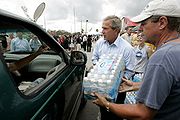 In the aftermath of the storm, many colleges and school districts across Florida remained closed. President George W. Bush
declared all of Florida a federal disaster area. Kennedy Space Center did not restore its complete work force until September 13 due to relief operations, as well as a lack of gasoline, ice, and water in the area. A total of 8000 members of the National Guard helped out with recovery efforts soon after the storm left the Florida peninsula. Residents in the areas of impact after the storm were under a boil water order, because of the lack of electricity to area water systems. Churches prepared meals for those without power and food themselves. Federal employees were granted excused absences if they helped with law enforcement and the cleanup. Thousands of portable generators were sent to the state by Home Depot and Lowe's
home improvement stores. The United States Army Corps of Engineers
installed blue tarpaulin
s on 41,556 damaged roofs statewide. Damage to the Florida citrus crop caused orange futures to rise four cents a pound due to Frances.
crop due to Frances, which led to a price rise in pecans by late October. Lost peach trees were expected to lower output during 2005, and increase peach prices. A disaster declaration was made for the northeast section of South Carolina on October 7. On September 10, President Bush declared 34 counties within North Carolina a disaster area, making them eligible for US$6.5 million (2004 dollars) in public assistance. A Wildlife Commission removed its North Carolina Mountain State Fair
exhibit due to Frances midway through the fair. Over 100,000 trout were lost due to the storm in the Pisgah, Table Rock, Marion, and Armstrong state fish hatcheries. Red Cross volunteers distributed over 200,000 gallons of water by its 600 volunteers in four days. After Frances and Hurricane Ivan
, Asheville
determined that it needed $14 million in order to buy out willing businesses and homes within the floodplain.
, the name Frances was retired in the spring of 2005 by the World Meteorological Organization
, and will never again be used for an Atlantic hurricane. It was replaced with Fiona
for the 2010 season. Due to a request by France in the 2003 WM0 Meeting, the name Frances was to be removed from the rotating cyclone lists after the 2004 hurricane season, even if Frances wasn't as desctructive, but the destruction caused by Frances in the United States was enough to warrant retirement on its own merit.
Tropical cyclone
A tropical cyclone is a storm system characterized by a large low-pressure center and numerous thunderstorms that produce strong winds and heavy rain. Tropical cyclones strengthen when water evaporated from the ocean is released as the saturated air rises, resulting in condensation of water vapor...
, the fourth hurricane
Tropical cyclone
A tropical cyclone is a storm system characterized by a large low-pressure center and numerous thunderstorms that produce strong winds and heavy rain. Tropical cyclones strengthen when water evaporated from the ocean is released as the saturated air rises, resulting in condensation of water vapor...
, and the third major hurricane of the 2004 Atlantic hurricane season
2004 Atlantic hurricane season
The 2004 Atlantic hurricane season officially began on June 1, 2004, and lasted until November 30, 2004. These dates conventionally delimit the period of each year when most tropical cyclones form in the Atlantic basin...
. The system crossing the open Atlantic during mid to late August, moving to the north of the Lesser Antilles while strengthening. Its outer bands affected Puerto Rico
Puerto Rico
Puerto Rico , officially the Commonwealth of Puerto Rico , is an unincorporated territory of the United States, located in the northeastern Caribbean, east of the Dominican Republic and west of both the United States Virgin Islands and the British Virgin Islands.Puerto Rico comprises an...
and the British Virgin Islands
British Virgin Islands
The Virgin Islands, often called the British Virgin Islands , is a British overseas territory and overseas territory of the European Union, located in the Caribbean to the east of Puerto Rico. The islands make up part of the Virgin Islands archipelago, the remaining islands constituting the U.S...
while passing north of the Caribbean sea
Caribbean Sea
The Caribbean Sea is a sea of the Atlantic Ocean located in the tropics of the Western hemisphere. It is bounded by Mexico and Central America to the west and southwest, to the north by the Greater Antilles, and to the east by the Lesser Antilles....
. The storm's maximum sustained wind
Maximum sustained wind
The maximum sustained winds associated with a tropical cyclone are a common indicator of the intensity of the storm. Within a mature tropical cyclone, they are found within the eyewall at a distance defined as the radius of maximum wind, or RMW. Unlike gusts, the value of these winds are...
speeds peaked at 145 miles per hour (233.4 km/h), achieving Category 4 on the Saffir-Simpson Hurricane Scale
Saffir-Simpson Hurricane Scale
The Saffir–Simpson Hurricane Scale , or the Saffir–Simpson Hurricane Wind Scale , classifies hurricanes — Western Hemisphere tropical cyclones that exceed the intensities of tropical depressions and tropical storms — into five categories distinguished by the intensities of their sustained winds...
. As the system slowed down its forward motion, the eye
Eye (cyclone)
The eye is a region of mostly calm weather found at the center of strong tropical cyclones. The eye of a storm is a roughly circular area and typically 30–65 km in diameter. It is surrounded by the eyewall, a ring of towering thunderstorms where the second most severe weather of a cyclone...
passed over San Salvador Island
San Salvador Island
San Salvador Island, also known as Watlings Island, is an island and district of the Bahamas. Until 1986, when the National Geographic Society suggested Samana Cay, it was widely believed that during his first expedition to the New World, San Salvador Island was the first land sighted and visited...
and very close to Cat Island in the Bahamas. Frances was the first hurricane to impact the entire Bahamian archipelago since 1866, and led to the nearly complete destruction of their agricultural economy.
Frances then passed over the central sections of the state of Florida
Florida
Florida is a state in the southeastern United States, located on the nation's Atlantic and Gulf coasts. It is bordered to the west by the Gulf of Mexico, to the north by Alabama and Georgia and to the east by the Atlantic Ocean. With a population of 18,801,310 as measured by the 2010 census, it...
in the U.S.
United States
The United States of America is a federal constitutional republic comprising fifty states and a federal district...
only three weeks after Hurricane Charley
Hurricane Charley
Hurricane Charley was the third named storm, the second hurricane, and the second major hurricane of the 2004 Atlantic hurricane season. Charley lasted from August 9 to August 15, and at its peak intensity it attained 150 mph winds, making it a strong Category 4 hurricane on the...
, causing significant damage to the state's citrus crop, closing schools and canceling a football game. The storm then moved briefly offshore Florida into the northeast Gulf of Mexico
Gulf of Mexico
The Gulf of Mexico is a partially landlocked ocean basin largely surrounded by the North American continent and the island of Cuba. It is bounded on the northeast, north and northwest by the Gulf Coast of the United States, on the southwest and south by Mexico, and on the southeast by Cuba. In...
and made a second U.S. landfall at the Florida Panhandle
Florida Panhandle
The Florida Panhandle, an informal, unofficial term for the northwestern part of Florida, is a strip of land roughly 200 miles long and 50 to 100 miles wide , lying between Alabama on the north and the west, Georgia also on the north, and the Gulf of Mexico to the south. Its eastern boundary is...
before accelerating northeast through the eastern United States
United States
The United States of America is a federal constitutional republic comprising fifty states and a federal district...
near the Appalachians into Atlantic Canada
Atlantic Canada
Atlantic Canada is the region of Canada comprising the four provinces located on the Atlantic coast, excluding Quebec: the three Maritime provinces – New Brunswick, Prince Edward Island, and Nova Scotia – and Newfoundland and Labrador...
while weakening. A significant tornado outbreak accompanied the storm across the eastern United States, nearly equaling the outbreak from Hurricane Beulah
Hurricane Beulah
Hurricane Beulah was the second tropical storm, second hurricane, and only major hurricane during the 1967 Atlantic hurricane season. It tracked through the Caribbean, struck the Yucatán peninsula of Mexico as a major hurricane, and moved west-northwest into the Gulf of Mexico, briefly gaining...
. Very heavy rains fell in association with this slow moving and relatively large hurricane, which led to floods in Florida and North Carolina. A total of 49 lives were lost from the cyclone
Cyclone
In meteorology, a cyclone is an area of closed, circular fluid motion rotating in the same direction as the Earth. This is usually characterized by inward spiraling winds that rotate anticlockwise in the Northern Hemisphere and clockwise in the Southern Hemisphere of the Earth. Most large-scale...
. Damages totaled US$12 billion (2004 dollars).
Meteorological history
A strong tropical wave moved off the west coast of AfricaAfrica
Africa is the world's second largest and second most populous continent, after Asia. At about 30.2 million km² including adjacent islands, it covers 6% of the Earth's total surface area and 20.4% of the total land area...
on August 21. Moving under the base of the subtropical ridge
Subtropical ridge
The subtropical ridge is a significant belt of high pressure situated around the latitudes of 30°N in the Northern Hemisphere and 30°S in the Southern Hemisphere. It is characterized by mostly calm winds, which acts to reduce air quality under its axis by causing fog overnight, and haze during...
, it moved westward for several days, remaining disorganized despite favorable conditions. Thunderstorms associated with the wave finally began organizing early on August 24, and the system became a tropical depression
Tropical cyclone
A tropical cyclone is a storm system characterized by a large low-pressure center and numerous thunderstorms that produce strong winds and heavy rain. Tropical cyclones strengthen when water evaporated from the ocean is released as the saturated air rises, resulting in condensation of water vapor...
that evening. Good upper-level outflow was observed in all but the eastern quadrants as the depression continued on its path, and the depression strengthened to tropical storm status on August 25, approximately 1420 miles (2,285.3 km) east of the Lesser Antilles
Lesser Antilles
The Lesser Antilles are a long, partly volcanic island arc in the Western Hemisphere. Most of its islands form the eastern boundary of the Caribbean Sea with the Atlantic Ocean, with the remainder located in the southern Caribbean just north of South America...
.
The tropical storm, now named Frances, further intensified on August 26 in an environment of low vertical wind shear
Wind shear
Wind shear, sometimes referred to as windshear or wind gradient, is a difference in wind speed and direction over a relatively short distance in the atmosphere...
as its track bent to the west-northwest. Frances rapidly intensified, developing an eye
Eye (cyclone)
The eye is a region of mostly calm weather found at the center of strong tropical cyclones. The eye of a storm is a roughly circular area and typically 30–65 km in diameter. It is surrounded by the eyewall, a ring of towering thunderstorms where the second most severe weather of a cyclone...
and reaching hurricane strength late that afternoon. An approaching upper level trough caused Frances to move more northwesterly on August 27. The cyclone reached its primary peak intensity of 135 mi/h on August 28. The hurricane turned back to its original westward motion on August 29, as the upper trough moved away the region and the subtropical ridge strengthened to Frances' north.
Eyewall replacement cycle
Eyewall replacement cycles, also called concentric eyewall cycles, naturally occur in intense tropical cyclones, generally with winds greater than 185 km/h , or major hurricanes...
, during which the maximum sustained winds decreased to 115 mi/h. This weakening trend was short lived, and the storm reintensified during the afternoon of August 30, as vertical wind shear remained low. The storm continued strengthening as it turned west-northwestward, reaching its peak intensity of 145 mi/h on September 2 while 555 miles (893.2 km) east-southeast of West Palm Beach, Florida
West Palm Beach, Florida
West Palm Beach, is a city located on the Atlantic coast in southeastern Florida and is the most populous city in and county seat of Palm Beach County, the third most populous county in Florida with a 2010 population of 1,320,134. The city is also the oldest incorporated municipality in South Florida...
. On September 2, Frances entered the Bahamas, passing directly over San Salvador Island
San Salvador Island
San Salvador Island, also known as Watlings Island, is an island and district of the Bahamas. Until 1986, when the National Geographic Society suggested Samana Cay, it was widely believed that during his first expedition to the New World, San Salvador Island was the first land sighted and visited...
and very close to Cat Island. The storm weakened to a Category 3 hurricane by 2 pm, which was initially attributed to inner core processes, but increasing westerly winds aloft, and the resultant vertical wind shear, was later determined to be the cause. On September 3, Frances passed into the vicinity of Abaco Island
Abaco Islands
The Abaco Islands lie in the northern Bahamas and comprise the main islands of Great Abaco and Little Abaco, together with the smaller Wood Cay, Elbow Cay, Lubbers Quarters Cay, Green Turtle Cay, Great Guana Cay, Castaway Cay, Man-o-War Cay, Stranger's Cay, Umbrella Cay, Walker's Cay, Little Grand...
and directly over Grand Bahama
Grand Bahama
Grand Bahama is one of the northernmost of the islands of the Bahamas, and the closest major island to the United States, lying off the state of Florida. Grand Bahama is the fifth largest island in the Bahamas island chain of approximately 700 islands and 2,400 cays...
while continuing to slowly weaken. The storm regained Category 2 hurricane intensity prior to passing over Grand Bahama Island and also slowed in forward speed due to a weakness in the subtropical ridge to its north. Parts of South Florida began to be affected by squalls and the outer rainband
Rainband
A rainband is a cloud and precipitation structure associated with an area of rainfall which is significantly elongated. Rainbands can be stratiform or convective, and are generated by differences in temperature. When noted on weather radar imagery, this precipitation elongation is referred to as...
s of the hurricane at this time. Gusts from 40 miles per hour (64.4 km/h) to as high as 87 miles per hour (140 km/h) were reported from Jupiter Inlet to Miami.
Frances moved slowly, between 5 miles per hour (8 km/h) to 10 miles per hour (16.1 km/h), as it crossed the warm Gulf Stream
Gulf Stream
The Gulf Stream, together with its northern extension towards Europe, the North Atlantic Drift, is a powerful, warm, and swift Atlantic ocean current that originates at the tip of Florida, and follows the eastern coastlines of the United States and Newfoundland before crossing the Atlantic Ocean...
between the Bahamas and Florida, leading to the concern that it could restrengthen. However, Frances remained stable at Category 2 intensity with 105 miles per hour (169 km/h) maximum sustained wind
Maximum sustained wind
The maximum sustained winds associated with a tropical cyclone are a common indicator of the intensity of the storm. Within a mature tropical cyclone, they are found within the eyewall at a distance defined as the radius of maximum wind, or RMW. Unlike gusts, the value of these winds are...
s while it battered the east coast of Florida between Fort Pierce
Fort Pierce, Florida
Fort Pierce, also spelled Ft. Pierce, is a city in St. Lucie County, Florida, USA. It is known as The Sunrise City. The population was 37,959 at the 2004 census. As of 2008, the population recorded by the U.S. Census Bureau is 41,000. It is the county seat of St. Lucie County.Fort Pierce is part...
and West Palm Beach
West Palm Beach, Florida
West Palm Beach, is a city located on the Atlantic coast in southeastern Florida and is the most populous city in and county seat of Palm Beach County, the third most populous county in Florida with a 2010 population of 1,320,134. The city is also the oldest incorporated municipality in South Florida...
for much of September 4. At 11 pm, the western edge of Frances' eyewall began moving onshore. Because of Frances' large eye, which was roughly 80 miles (128.7 km) across, and its slow forward motion, the center of circulation remained offshore for several more hours. At 1 am EDT on September 5 (0500 UTC), the center of the broad eye of Frances made landfall
Landfall (meteorology)
Landfall is the event of a tropical cyclone or a waterspout coming onto land after being over water. When a waterspout makes landfall it is reclassified as a tornado, which can then cause damage inland...
along the Florida coast, at the southern end of Hutchinson Island, near Sewall's Point
Sewall's Point, Florida
Sewall's Point is a town located on the peninsula of the same name in Martin County, Florida, United States. The population was 1,946 at the 2000 census. As of 2004, the population recorded by the U.S. Census Bureau is 2,053 . Both the town and the peninsula are named for Capt...
, Jensen Beach
Jensen Beach, Florida
Jensen Beach is a census-designated place in Martin County, Florida, United States. The population was 11,100 at the 2000 census. It is part of the Port St...
and Port Salerno, Florida
Port Salerno, Florida
Port Salerno is a census-designated place in Martin County, Florida, United States. The population was 10,141 at the 2000 census. It is part of the Port St...
. Late on September 5, Frances picked up speed due to a strengthening high pressure system to its north and crossed the Florida Peninsula
Florida
Florida is a state in the southeastern United States, located on the nation's Atlantic and Gulf coasts. It is bordered to the west by the Gulf of Mexico, to the north by Alabama and Georgia and to the east by the Atlantic Ocean. With a population of 18,801,310 as measured by the 2010 census, it...
, emerging over the Gulf of Mexico
Gulf of Mexico
The Gulf of Mexico is a partially landlocked ocean basin largely surrounded by the North American continent and the island of Cuba. It is bounded on the northeast, north and northwest by the Gulf Coast of the United States, on the southwest and south by Mexico, and on the southeast by Cuba. In...
near Tampa
Tampa, Florida
Tampa is a city in the U.S. state of Florida. It serves as the county seat for Hillsborough County. Tampa is located on the west coast of Florida. The population of Tampa in 2010 was 335,709....
as a tropical storm. After a short trip over the Gulf of Mexico, Frances made a second landfall near St. Marks, Florida
St. Marks, Florida
St. Marks is a city in Wakulla County, Florida, United States. It is part of the Tallahassee, Florida, Metropolitan Statistical Area. The population was 272 at the 2000 census. As of 2004, the population estimated by the U.S. Census Bureau is 299 .-Geography:...
. Frances headed inland, weakening to a tropical depression and causing heavy rainfall over the southern and eastern United States. As Tropical Depression Frances turned northeast, United States
United States
The United States of America is a federal constitutional republic comprising fifty states and a federal district...
meteorologists at the Hydrometeorological Prediction Center
Hydrometeorological Prediction Center
The Hydrometeorological Prediction Center is one of nine service centers under the umbrella of the National Centers for Environmental Prediction , a part of the National Weather Service, which in turn is part of the National Oceanic and Atmospheric Administration of the U.S. government...
continued issuing advisories on the system until it crossed the Canadian
Canada
Canada is a North American country consisting of ten provinces and three territories. Located in the northern part of the continent, it extends from the Atlantic Ocean in the east to the Pacific Ocean in the west, and northward into the Arctic Ocean...
border into Quebec
Quebec
Quebec or is a province in east-central Canada. It is the only Canadian province with a predominantly French-speaking population and the only one whose sole official language is French at the provincial level....
, where heavy rainfall also fell.
Preparations
A tropical storm watch was issued for Frances for the Leeward Islands during the afternoon of August 29, which was upgraded to a warning that night and expanded to include the islands of Anguilla, Antigua, Barbuda, Nevis, Saba, St. Kitts, St. Eustatius, and St. Maarten. A hurricane watch was issued during the night of August 29 for the northern British Virgin IslandsBritish Virgin Islands
The Virgin Islands, often called the British Virgin Islands , is a British overseas territory and overseas territory of the European Union, located in the Caribbean to the east of Puerto Rico. The islands make up part of the Virgin Islands archipelago, the remaining islands constituting the U.S...
, the northern United States Virgin Islands
United States Virgin Islands
The Virgin Islands of the United States are a group of islands in the Caribbean that are an insular area of the United States. The islands are geographically part of the Virgin Islands archipelago and are located in the Leeward Islands of the Lesser Antilles.The U.S...
, Culebra
Culebra, Puerto Rico
Isla Culebra is an island-municipality of Puerto Rico originally called Isla Pasaje and Isla de San Ildefonso. It is located approximately east of the Puerto Rican mainland, west of St. Thomas and north of Vieques. Culebra is spread over 5 wards and Culebra Pueblo...
, and Vieques. On the morning of August 30, the hurricane watch for Vieques was downgraded to a tropical storm watch. That afternoon, hurricane watches were changed to tropical storm warnings across Puerto Rico, Culebra, Vieques, British Virgin Islands, and the northern U. S. Virgin Islands while a tropical storm watch was issued for St. Croix while all remaining hurricane watches were dropped. That night, tropical storm watches were issued for eastern portions of the northern coast of the Dominican Republic while a tropical storm warning was issued for Guadeloupe.
Early on the morning of August 31, tropical storm warnings were dropped for Antigua, Barbuda, Nevis, and St. Kitts while hurricane watches were issued for the southeast Bahamas as well as the Turks and Caicos Islands. Hurricane watches were upgraded to hurricane warnings later that morning. Toward noon, tropical storm warnings were issued for the remainder of the northern coast of the Dominican Republic, a hurricane watch was issued for the central Bahamas, while all watches and warnings were dropped for northeast portion of the Dominican Republic and portions of the Lesser Antilles south of the British Virgin Islands. That afternoon, tropical storm warnings were dropped from Puerto Rico eastward. On the morning of September 1, a hurricane watch was issued for the northwest Bahamas while the watch for the central Bahamas was upgraded to a warning. That afternoon, warnings were dropped for the Dominican Republic.
On the evening of September 1, hurricane warnings were issued for the northwest Bahamas while hurricane watches were issued for the lower east coast of Florida and tropical storm watches were issued for the Florida Keys. There was the potential for catastrophic damage along Florida's heavily-populated east coast, with warnings that damages from Frances could exceed the insured losses of Hurricane Andrew
Hurricane Andrew
Hurricane Andrew was the third Category 5 hurricane to make landfall in the United States, after the Labor Day Hurricane of 1935 and Hurricane Camille in 1969. Andrew was the first named storm and only major hurricane of the otherwise inactive 1992 Atlantic hurricane season...
. These damage estimates were in anticipation that Frances would strike Florida as a strong Category Four hurricane. Preparations for the storm were stepped up in Florida on September 1. Governor Jeb Bush
Jeb Bush
John Ellis "Jeb" Bush is an American politician who served as the 43rd Governor of Florida from 1999 to 2007. He is a prominent member of the Bush family: the second son of former President George H. W. Bush and former First Lady Barbara Bush; the younger brother of former President George W...
declared a state of emergency
State of emergency
A state of emergency is a governmental declaration that may suspend some normal functions of the executive, legislative and judicial powers, alert citizens to change their normal behaviours, or order government agencies to implement emergency preparedness plans. It can also be used as a rationale...
, Kennedy Space Center closed down, and evacuations of 500,000 people were initially ordered. Eventually 41 counties received evacuation orders, covering 2.8 million residents, the largest evacuation in Florida's history. The state education system also responded to the pending crisis. Many universities across Florida canceled classes. Both the University of Central Florida
University of Central Florida
The University of Central Florida, commonly referred to as UCF, is a metropolitan public research university located in Orlando, Florida, United States...
and the University of North Florida
University of North Florida
The University of North Florida is a public university located in Jacksonville, Florida. A member institution of the State University System of Florida, the university is accredited by the Commission on Colleges of the Southern Association of Colleges and Schools to award baccalaureate, master’s...
told all students to leave their dorms. Evacuation at the University of South Florida
University of South Florida
The University of South Florida, also known as USF, is a member institution of the State University System of Florida, one of the state's three flagship universities for public research, and is located in Tampa, Florida, USA...
was performed on a dorm-by-dorm basis. Florida Atlantic University
Florida Atlantic University
Florida Atlantic University, also referred to as FAU or Florida Atlantic, is a public, coeducational, research university located in , United States. The university has six satellite campuses located in the Florida cities of Dania Beach, Davie, Fort Lauderdale, Jupiter, Port St. Lucie, and in Fort...
was closed for a week and a half. Most schools were shut down from southern Miami-Dade County to just south of Melbourne
Melbourne
Melbourne is the capital and most populous city in the state of Victoria, and the second most populous city in Australia. The Melbourne City Centre is the hub of the greater metropolitan area and the Census statistical division—of which "Melbourne" is the common name. As of June 2009, the greater...
two days before the hurricane. The annual Florida State University
Florida State University
The Florida State University is a space-grant and sea-grant public university located in Tallahassee, Florida, United States. It is a comprehensive doctoral research university with medical programs and significant research activity as determined by the Carnegie Foundation...
-University of Miami
University of Miami
The University of Miami is a private, non-sectarian university founded in 1925 with its main campus in Coral Gables, Florida, a medical campus in Miami city proper at Civic Center, and an oceanographic research facility on Virginia Key., the university currently enrolls 15,629 students in 12...
college football game was rescheduled for the following week.
St. Marks, Florida
St. Marks is a city in Wakulla County, Florida, United States. It is part of the Tallahassee, Florida, Metropolitan Statistical Area. The population was 272 at the 2000 census. As of 2004, the population estimated by the U.S. Census Bureau is 299 .-Geography:...
, and watches were extended westward to Panama City, Florida
Panama City, Florida
-Personal income:The median income for a household in the city was $31,572, and the median income for a family was $40,890. Males had a median income of $30,401 versus $21,431 for females. The per capita income for the city was $17,830...
.
Early on morning of September 5, hurricane warnings were downgraded to tropical storm warnings south of Deerfield Beach, Florida
Deerfield Beach, Florida
Deerfield Beach is a city in Broward County, Florida, USA. The city is named for the numerous deer that once roamed the area. As of the 2010 United States Census, the population was 75,018...
while tropical storm warnings were extended westward through the western Florida Keys. Later that morning, hurricane warnings were issued for most of the northwest Florida coast while hurricane watches were lowered for northeast Florida and hurricane warnings were dropped for the remainder of the northwest Bahamas. That afternoon, all warnings were dropped for southeast Florida south of Jupiter Inlet, while the remaining hurricane warnings along the east Florida coast were downgraded to tropical storm warnings. Hurricane warnings along the coast of western Florida were extended southward to Anna Maria Island. Late that night, tropical storm warnings were dropped south of Bonita Beach including all the Florida Keys. Early on the morning of September 6, all warnings were dropped in Florida south of Englewood and Cocoa Beach. Later that morning, hurricane warnings were downgraded to tropical storm warnings between Indian Pass and Destin as well as between Anna Maria Island and the Suwannee River
Suwannee River
The Suwannee River is a major river of southern Georgia and northern Florida in the United States. It is a wild blackwater river, about long. The Suwannee River is the site of the prehistoric Suwannee Straits which separated peninsular Florida from the panhandle.-Geography:The river rises in the...
while all remaining warnings were dropped south of Anna Maria Island, as well as the Florida east coast and the Georgia coast. That afternoon, all hurricane warnings were downgraded to tropical storm warnings, with all warnings dropped between west of St. Marks and south of the Suwannee river. On the night of September 6, all remaining tropical cyclone warnings were dropped.
Impact
Labor Day
Labor Day is a United States federal holiday observed on the first Monday in September that celebrates the economic and social contributions of workers.-History:...
weekend, traditionally the final summer vacation weekend in the United States
United States
The United States of America is a federal constitutional republic comprising fifty states and a federal district...
. Many hotel reservations from South Carolina
South Carolina
South Carolina is a state in the Deep South of the United States that borders Georgia to the south, North Carolina to the north, and the Atlantic Ocean to the east. Originally part of the Province of Carolina, the Province of South Carolina was one of the 13 colonies that declared independence...
to Florida
Florida
Florida is a state in the southeastern United States, located on the nation's Atlantic and Gulf coasts. It is bordered to the west by the Gulf of Mexico, to the north by Alabama and Georgia and to the east by the Atlantic Ocean. With a population of 18,801,310 as measured by the 2010 census, it...
were cancelled as people, seeing the destruction caused weeks earlier by Hurricane Charley, decided to avoid the coastal areas for safety. One death in the Bahamas, one in Ohio
Ohio
Ohio is a Midwestern state in the United States. The 34th largest state by area in the U.S.,it is the 7th‑most populous with over 11.5 million residents, containing several major American cities and seven metropolitan areas with populations of 500,000 or more.The state's capital is Columbus...
, and five in Florida were directly attributed to the storm. 42 more deaths - 32 in Florida, eight in Georgia
Georgia (U.S. state)
Georgia is a state located in the southeastern United States. It was established in 1732, the last of the original Thirteen Colonies. The state is named after King George II of Great Britain. Georgia was the fourth state to ratify the United States Constitution, on January 2, 1788...
, one in the Bahamas and one in Ohio, are indirectly attributed to Frances.
The total civilian damage from Frances was determined to be approximately US$8,830,000,000 (2004 dollars). Add in the estimated US$100 million damage (2004 dollars) done to space and military facilities at Cape Canaveral, Florida
Cape Canaveral, Florida
Cape Canaveral is a city in Brevard County, Florida, United States. The population was 8,829 at the 2000 census. As of 2008, the estimated population according to the U.S. Census Bureau was 10,147...
and the total damage was estimated to be about US$9 billion (2004 dollars), making it the fourth costliest hurricane in United States history at that time, behind Hurricane Andrew
Hurricane Andrew
Hurricane Andrew was the third Category 5 hurricane to make landfall in the United States, after the Labor Day Hurricane of 1935 and Hurricane Camille in 1969. Andrew was the first named storm and only major hurricane of the otherwise inactive 1992 Atlantic hurricane season...
of 1992 and Hurricanes Charley
Hurricane Charley
Hurricane Charley was the third named storm, the second hurricane, and the second major hurricane of the 2004 Atlantic hurricane season. Charley lasted from August 9 to August 15, and at its peak intensity it attained 150 mph winds, making it a strong Category 4 hurricane on the...
and Ivan
Hurricane Ivan
Hurricane Ivan was a large, long-lived, Cape Verde-type hurricane that caused widespread damage in the Caribbean and United States. The cyclone was the ninth named storm, the sixth hurricane and the fourth major hurricane of the active 2004 Atlantic hurricane season...
of 2004. At the time, adjusted for inflation, it became the seventh costliest hurricane for the lower 48 United States
United States
The United States of America is a federal constitutional republic comprising fifty states and a federal district...
.
Bahamas
About 75% of the island chain lost power for a few hours during the storm. Damage occurred to downed trees and wooden homes. Between 13 and 17 percent of the non-native Australian pine on San SalvadorSan Salvador
The city of San Salvador the capital and largest city of El Salvador, which has been designated a Gamma World City. Its complete name is La Ciudad de Gran San Salvador...
island experienced damage, primarily from snapping, though some browning from salt spray was noted. Several feet of water flooded the international airport at Freeport
Freeport, Bahamas
Freeport is a city, district and free trade zone located on the island of Grand Bahama of the North-west Bahamas. In 1955, Wallace Groves, a Virginian financier with lumber interests in Grand Bahama, was granted 50,000 acres Freeport is a city, district and free trade zone located on the island of...
.
In the Bahamas, insurers and reinsurers estimated industry insured losses at about $300 million (2004 dollars). All cool-season vegetable plantings, and the entire banana crop, were lost during Frances. The pineapple crop was significantly impacted by wind damage in Eleuthera
Eleuthera
Eleuthera is an island in The Bahamas, lying 50 miles east of Nassau. It is very long and thin—110 miles long and in places little more than a mile wide. According to the 2000 Census, the population of Eleuthera is approximately 8,000...
, while the entire fruit crop was lost for similar reasons. The corn crop in Long Island
Long Island
Long Island is an island located in the southeast part of the U.S. state of New York, just east of Manhattan. Stretching northeast into the Atlantic Ocean, Long Island contains four counties, two of which are boroughs of New York City , and two of which are mainly suburban...
and Cat Island
Cat Island (Bahamas)
Cat Island is in the central Bahamas, and one of its districts, and has the nation's highest point. Its Mount Alvernia rises to 206 ft and is topped by a monastery called The Hermitage. This assembly of buildings was erected by the Franciscan "Brother Jerome" .The first European settlers were...
was completely lost. Significant poultry losses were experienced. Like with other hurricane-induced damage, to get the total damage in the area, the insured damage is multiplied by a factor of 2, which comes out to $600 million (2004 dollars).
Florida
Kissimmee River
The Kissimmee River is a river in south-central Florida, United States.-Course:The Kissimmee River arises in Osceola County as the outflow from East Lake Tohopekaliga, passing through Lake Tohopekaliga, Lake Cypress, Lake Hatchineha and Lake Kissimmee...
basin. Between Hurricane Charley and Frances, citrus losses totaled $2 billion (2004 dollars). Significant tree damage was reported within golf courses along the Treasure Coast
Treasure Coast
The Treasure Coast is a region in the U.S. state of Florida, generally considered to include Indian River, St. Lucie, and Martin counties. The area stretches from Hobe Sound in the south to north of Sebastian in the north and includes the cities of Stuart, Port St. Lucie, Fort Pierce, and Vero Beach...
, with an average of 300-500 trees experiencing damage per course.
Some areas of Florida received over 13 inches (330.2 mm) of rain as the system moved slowly through the state. Heavy rains caused a large sinkhole
Sinkhole
A sinkhole, also known as a sink, shake hole, swallow hole, swallet, doline or cenote, is a natural depression or hole in the Earth's surface caused by karst processes — the chemical dissolution of carbonate rocks or suffosion processes for example in sandstone...
to develop on Interstate 95
Interstate 95
Interstate 95 is the main highway on the East Coast of the United States, running parallel to the Atlantic Ocean from Maine to Florida and serving some of the most populated urban areas in the country, including Boston, Providence, New Haven, New York City, Newark, Philadelphia, Baltimore,...
in Palm Beach County, which closed the highway to traffic. Similar to Hurricane Charley
Hurricane Charley
Hurricane Charley was the third named storm, the second hurricane, and the second major hurricane of the 2004 Atlantic hurricane season. Charley lasted from August 9 to August 15, and at its peak intensity it attained 150 mph winds, making it a strong Category 4 hurricane on the...
earlier in the month, the Florida citrus
Citrus
Citrus is a common term and genus of flowering plants in the rue family, Rutaceae. Citrus is believed to have originated in the part of Southeast Asia bordered by Northeastern India, Myanmar and the Yunnan province of China...
crops took large amounts of damage. Frances caused heavy damage to the large Vehicle Assembly Building
Vehicle Assembly Building
The Vehicle Assembly Building, or VAB, at NASA's Kennedy Space Center was used to assemble and house American manned launch vehicles from 1968-2011. It is the fourth largest building in the world by volume...
at the Kennedy Space Center
Kennedy Space Center
The John F. Kennedy Space Center is the NASA installation that has been the launch site for every United States human space flight since 1968. Although such flights are currently on hiatus, KSC continues to manage and operate unmanned rocket launch facilities for America's civilian space program...
, ripping off over a thousand 4-by-10 foot aluminum panels used to clad the building. While Charley caused $700,000 damage (2004 dollars), Frances damage was significantly greater. Two external fuel tanks for the space shuttle
Space Shuttle
The Space Shuttle was a manned orbital rocket and spacecraft system operated by NASA on 135 missions from 1981 to 2011. The system combined rocket launch, orbital spacecraft, and re-entry spaceplane with modular add-ons...
were in the building but seem undamaged. The Space Shuttle Discovery
Space Shuttle Discovery
Space Shuttle Discovery is one of the retired orbiters of the Space Shuttle program of NASA, the space agency of the United States, and was operational from its maiden flight, STS-41-D on August 30, 1984, until its final landing during STS-133 on March 9, 2011...
's hangar was without power. The total damage to space and military facilities around Cape Canaveral, Florida
Cape Canaveral, Florida
Cape Canaveral is a city in Brevard County, Florida, United States. The population was 8,829 at the 2000 census. As of 2008, the estimated population according to the U.S. Census Bureau was 10,147...
was reported at about $100 million (2004 dollars). Orlando, Florida
Orlando, Florida
Orlando is a city in the central region of the U.S. state of Florida. It is the county seat of Orange County, and the center of the Greater Orlando metropolitan area. According to the 2010 US Census, the city had a population of 238,300, making Orlando the 79th largest city in the United States...
's theme parks closed Sunday — only the third time Walt Disney World closed for a hurricane, but the second time in a month.
Georgia
Frances dropped significant rain on Florida, Georgia, AlabamaAlabama
Alabama is a state located in the southeastern region of the United States. It is bordered by Tennessee to the north, Georgia to the east, Florida and the Gulf of Mexico to the south, and Mississippi to the west. Alabama ranks 30th in total land area and ranks second in the size of its inland...
, and North
North Carolina
North Carolina is a state located in the southeastern United States. The state borders South Carolina and Georgia to the south, Tennessee to the west and Virginia to the north. North Carolina contains 100 counties. Its capital is Raleigh, and its largest city is Charlotte...
and South Carolina
South Carolina
South Carolina is a state in the Deep South of the United States that borders Georgia to the south, North Carolina to the north, and the Atlantic Ocean to the east. Originally part of the Province of Carolina, the Province of South Carolina was one of the 13 colonies that declared independence...
. The passage of tropical depression Frances into Georgia dumped up to 5 inches (127 mm) of rain onto the state and caused the closings of schools in 56 counties. Across Georgia, winds of 30 miles per hour (48.3 km/h) to 40 miles per hour (64.4 km/h), with gusts to 50 miles per hour (80.5 km/h) led to the downing of tree branches and power lines. At one point on September 7, a total of 380,000 residences were without power. Significant crop damage was seen, particularly to the cotton and the peanut crops. On average, 30 percent of the crops were lost during Frances.
Carolinas
Flooding was reported even in the mid-Atlantic and Northeast states, particularly along the Appalachian MountainsAppalachian Mountains
The Appalachian Mountains #Whether the stressed vowel is or ,#Whether the "ch" is pronounced as a fricative or an affricate , and#Whether the final vowel is the monophthong or the diphthong .), often called the Appalachians, are a system of mountains in eastern North America. The Appalachians...
. A strip of upslope-induced rainfall along the Blue Ridge escarpment produced as much as 23 inches (584.2 mm) of rain in some areas of western North Carolina as the warm tropical air surged up and over the mountains. The flooding from this along the Swannanoa River
Swannanoa River
The Swannanoa River flows through the Swannanoa Valley of western North Carolina, and is a major tributary to the French Broad River. It begins at its headwaters in Black Mountain, NC, however, it also has a major tributary near its headwaters: Flat Creek, which begins on the slopes of Mount...
near Asheville, North Carolina
Asheville, North Carolina
Asheville is a city in and the county seat of Buncombe County, North Carolina, United States. It is the largest city in Western North Carolina, and the 11th largest city in North Carolina. The City is home to the United States National Climatic Data Center , which is the world's largest active...
caused a major break in the Asheville's water distribution system, leaving the city without water for several days. Significant crop damage was seen into North Carolina, which reported $55 million in crop damage. Frances also spawned 101 tornado
Tornado
A tornado is a violent, dangerous, rotating column of air that is in contact with both the surface of the earth and a cumulonimbus cloud or, in rare cases, the base of a cumulus cloud. They are often referred to as a twister or a cyclone, although the word cyclone is used in meteorology in a wider...
es from Florida
Florida
Florida is a state in the southeastern United States, located on the nation's Atlantic and Gulf coasts. It is bordered to the west by the Gulf of Mexico, to the north by Alabama and Georgia and to the east by the Atlantic Ocean. With a population of 18,801,310 as measured by the 2010 census, it...
to as far north as Virginia
Virginia
The Commonwealth of Virginia , is a U.S. state on the Atlantic Coast of the Southern United States. Virginia is nicknamed the "Old Dominion" and sometimes the "Mother of Presidents" after the eight U.S. presidents born there...
, shy of the single storm tornado record set during Hurricane Beulah
Hurricane Beulah
Hurricane Beulah was the second tropical storm, second hurricane, and only major hurricane during the 1967 Atlantic hurricane season. It tracked through the Caribbean, struck the Yucatán peninsula of Mexico as a major hurricane, and moved west-northwest into the Gulf of Mexico, briefly gaining...
.
Power outages affected up to six million people. Over 20 airports closed during the storm.
Canada
As an extratropical cycloneExtratropical cyclone
Extratropical cyclones, sometimes called mid-latitude cyclones or wave cyclones, are a group of cyclones defined as synoptic scale low pressure weather systems that occur in the middle latitudes of the Earth having neither tropical nor polar characteristics, and are connected with fronts and...
, Frances passed through southern Ontario
Ontario
Ontario is a province of Canada, located in east-central Canada. It is Canada's most populous province and second largest in total area. It is home to the nation's most populous city, Toronto, and the nation's capital, Ottawa....
. The storm dropped up to 5.39 inches (136.9 mm), washing out roads and causing localized flooding in Quebec
Quebec
Quebec or is a province in east-central Canada. It is the only Canadian province with a predominantly French-speaking population and the only one whose sole official language is French at the provincial level....
, New Brunswick
New Brunswick
New Brunswick is one of Canada's three Maritime provinces and is the only province in the federation that is constitutionally bilingual . The provincial capital is Fredericton and Saint John is the most populous city. Greater Moncton is the largest Census Metropolitan Area...
, and Newfoundland
Newfoundland and Labrador
Newfoundland and Labrador is the easternmost province of Canada. Situated in the country's Atlantic region, it incorporates the island of Newfoundland and mainland Labrador with a combined area of . As of April 2011, the province's estimated population is 508,400...
. This rainfall smashed all-time rainfall records in a 24-hour period (most of the rain fell in a 6 to 8 hour-period). Ottawa's O-Train transit rail was halted because of a landslide
Landslide
A landslide or landslip is a geological phenomenon which includes a wide range of ground movement, such as rockfalls, deep failure of slopes and shallow debris flows, which can occur in offshore, coastal and onshore environments...
that obstructed the railroad corridor. Several major roads in Gatineau
Gatineau
Gatineau is a city in western Quebec, Canada. It is the fourth largest city in the province. It is located on the northern banks of the Ottawa River, immediately across from Ottawa, Ontario, and together they form Canada's National Capital Region. Ottawa and Gatineau comprise a single Census...
and Ottawa were under several inches of water, locally chest-high. More than $45 million (2004 CAD
Canadian dollar
The Canadian dollar is the currency of Canada. As of 2007, the Canadian dollar is the 7th most traded currency in the world. It is abbreviated with the dollar sign $, or C$ to distinguish it from other dollar-denominated currencies...
; $41 million USD) in insured damage was reported in Ontario
Ontario
Ontario is a province of Canada, located in east-central Canada. It is Canada's most populous province and second largest in total area. It is home to the nation's most populous city, Toronto, and the nation's capital, Ottawa....
.
Bahamas
Frances was the first hurricane to impact the entire archipelago since 1866. On September 4, teams from the Ministry of Works, the Department of Environmental Health Services, the Royal Bahamas Defence Force and the Royal Bahamas Police Force were used to clear roadways of tree debris while utilities attempted to restore power and water in New Providence. The Family Islands were surveyed on September 5 and 6, when it was noted that major damage occurred within the island group. Telecommunications were restored to most of the island chain within 24 hours. As of September 21, electricity had been restored to half of the Bahamians who had lost power. Western sections of Grand Bahama Island remained without power into Hurricane Jeanne, which was the most significantly impacted island. The onion crop was expected to be late in 2005 due to the loss of seedbeds and seedlings during the storm.Florida
George W. Bush
George Walker Bush is an American politician who served as the 43rd President of the United States, from 2001 to 2009. Before that, he was the 46th Governor of Texas, having served from 1995 to 2000....
declared all of Florida a federal disaster area. Kennedy Space Center did not restore its complete work force until September 13 due to relief operations, as well as a lack of gasoline, ice, and water in the area. A total of 8000 members of the National Guard helped out with recovery efforts soon after the storm left the Florida peninsula. Residents in the areas of impact after the storm were under a boil water order, because of the lack of electricity to area water systems. Churches prepared meals for those without power and food themselves. Federal employees were granted excused absences if they helped with law enforcement and the cleanup. Thousands of portable generators were sent to the state by Home Depot and Lowe's
Lowe's
Lowe's Companies, Inc. is a U.S.-based chain of retail home improvement and appliance stores. Founded in 1946 in North Wilkesboro, North Carolina, the chain now serves more than 14 million customers a week in its 1,710 stores in the United States and 20 in Canada. Expansion into Canada began in...
home improvement stores. The United States Army Corps of Engineers
United States Army Corps of Engineers
The United States Army Corps of Engineers is a federal agency and a major Army command made up of some 38,000 civilian and military personnel, making it the world's largest public engineering, design and construction management agency...
installed blue tarpaulin
Tarpaulin
A tarpaulin, colloquially tarp, is a large sheet of strong, flexible, water-resistant or waterproof material, often cloth such as canvas or polyester coated with urethane, or made of plastics such as polyethylene. In some places such as Australia, and in military slang, a tarp may be known as a...
s on 41,556 damaged roofs statewide. Damage to the Florida citrus crop caused orange futures to rise four cents a pound due to Frances.
Georgia and the Carolinas
On September 24, the southern two-thirds of Georgia was declared a disaster by President Bush. The state lost 50 percent of its pecanPecan
The pecan , Carya illinoinensis, is a species of hickory, native to south-central North America, in Mexico from Coahuila south to Jalisco and Veracruz, in the United States from southern Iowa, Illinois, Missouri, and Indiana east to western Kentucky, southwestern Ohio, North Carolina, South...
crop due to Frances, which led to a price rise in pecans by late October. Lost peach trees were expected to lower output during 2005, and increase peach prices. A disaster declaration was made for the northeast section of South Carolina on October 7. On September 10, President Bush declared 34 counties within North Carolina a disaster area, making them eligible for US$6.5 million (2004 dollars) in public assistance. A Wildlife Commission removed its North Carolina Mountain State Fair
North Carolina Mountain State Fair
The North Carolina Mountain State Fair is a ten-day long agricultural fair which occurs annually in mid-September in Fletcher, North Carolina. Their slogan is "How the West Was Fun!" Annual attendance at the fair averages 171,290, with half the attendees between the ages of 20 and 49. Tickets...
exhibit due to Frances midway through the fair. Over 100,000 trout were lost due to the storm in the Pisgah, Table Rock, Marion, and Armstrong state fish hatcheries. Red Cross volunteers distributed over 200,000 gallons of water by its 600 volunteers in four days. After Frances and Hurricane Ivan
Hurricane Ivan
Hurricane Ivan was a large, long-lived, Cape Verde-type hurricane that caused widespread damage in the Caribbean and United States. The cyclone was the ninth named storm, the sixth hurricane and the fourth major hurricane of the active 2004 Atlantic hurricane season...
, Asheville
Asheville, North Carolina
Asheville is a city in and the county seat of Buncombe County, North Carolina, United States. It is the largest city in Western North Carolina, and the 11th largest city in North Carolina. The City is home to the United States National Climatic Data Center , which is the world's largest active...
determined that it needed $14 million in order to buy out willing businesses and homes within the floodplain.
Retirement
Because of its effects in the United StatesUnited States
The United States of America is a federal constitutional republic comprising fifty states and a federal district...
, the name Frances was retired in the spring of 2005 by the World Meteorological Organization
World Meteorological Organization
The World Meteorological Organization is an intergovernmental organization with a membership of 189 Member States and Territories. It originated from the International Meteorological Organization , which was founded in 1873...
, and will never again be used for an Atlantic hurricane. It was replaced with Fiona
Tropical Storm Fiona (2010)
Tropical Storm Fiona was the eighth tropical depression and sixth tropical storm in the 2010 Atlantic hurricane season. A weak and disorganized storm, it originated from a tropical wave that moved into the Atlantic Ocean late on August 25. After struggling to develop, it became a tropical storm on...
for the 2010 season. Due to a request by France in the 2003 WM0 Meeting, the name Frances was to be removed from the rotating cyclone lists after the 2004 hurricane season, even if Frances wasn't as desctructive, but the destruction caused by Frances in the United States was enough to warrant retirement on its own merit.
See also
- List of Florida hurricanes (2000-present)
- List of retired Atlantic hurricane names
- Hurricane Frances tornado outbreakHurricane Frances tornado outbreakThe 2004 Hurricane Frances tornado outbreak was a widespread tornado outbreak associated with Hurricane Frances that came ashore on eastern Florida on September 4–5, 2004...
- List of Category 4 Atlantic hurricanes