
Hurricane Cleo
Encyclopedia
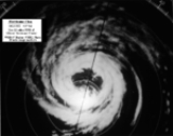
Hurricane Cleo was the third named storm, first hurricane, and first major hurricane of the 1964 Atlantic hurricane season
. Cleo was one of the longest-lived storms of the season. This compact yet powerful hurricane travelled through the Caribbean Sea
and later hit Florida
before moving offshore Georgia
into the Carolinas, killing 217 people and causing over US$1 billion in normalized damages. Major damage was seen as far north as east-central Florida
, with the heaviest rains falling along the immediate coast of the Southeast United States into southeast Virginia
.
on August 20–as reported by a Navy reconnaissance plane. It continued west-northwestward, quickly strengthening to a hurricane the next day with a minimum central pressure of 993 mb
. Early in the afternoon of August 22, Cleo crossed Guadeloupe
as a 115 mph (185 km/h) Category 3 hurricane. The hurricane continued to strengthen as it moved through the Caribbean Sea and reached its peak intensity of 155 mph (250 km/h) on the August 23 while south of the Dominican Republic
. It maintained that intensity for a day, bringing heavy rain and winds to Hispaniola
. As Cleo passed south of Haiti
on August 24, it veered northward momentarily, enough to move on to the Southwest Peninsula of Haiti. The circulation of the hurricane was greatly disrupted by the mountainous terrain of the island, quickly weakening the hurricane.
Cleo weakened to a Category 1 hurricane before hitting southern Cuba
on the August 26. It crossed the island quickly. Shortly after emerging from the north coast of Cuba, Cleo restrengthened to a hurricane, having weakened to a tropical storm while over Cuba. Cleo managed to intensify to a 100 mph (160 km/h), Category 2 hurricane before hitting the Miami, Florida
area on August 27. It weakened to a tropical storm while over Florida
on the 28th. The center moved offshore between Jacksonville
and St. Augustine, Florida
, before moving back onshore near Savannah, Georgia
on August 29 without any increase in intensity. Its northward path along the Florida coast was unusual for the month of August.
Cleo continued to weaken as it moved through the Carolinas, drifting through as a tropical depression. After bringing heavy rain through the area, Cleo exited into the Atlantic Ocean near Norfolk, Virginia
, and quickly intensified to a tropical storm again on the September 1. The following day, Cleo became a hurricane again, but it remained well offshore and did not cause any further damage. Cleo finally dissipated on September 5 northeast of Newfoundland.
and the Windward Islands
. On August 22 hurricane warnings were in effect for Puerto Rico and the Virgin Islands
, with hurricane watches in effect for Haiti and the Dominican Republic. By August 23, hurricane watches remained in effect for the Dominican Republic and Haiti. Hurricane warnings were issued for Jamaica
on August 24. By August 26 a hurricane watch had been raised from Key Largo, Florida
to West Palm Beach, Florida
. In advance of Cleo, the second stage of the Titan II/Gemini
launch vehicle was taken down and stored in a hangar on August 26 to protect it from the storm. Early on August 27, hurricane warnings extended northward to Cape Kennedy, Florida
with gale warnings northward to Daytona Beach, Florida
. Hurricane warnings were in effect northward to Brunswick, Georgia
early on August 28 with a hurricane watch in effect between Brunswick, Georgia and Charleston, South Carolina
. The hurricane watch for portions of the Georgia and South Carolina coasts continued into August 29.
indicated 14 dead, 40 injured, 1,000 homes destroyed and extensive damage to the island's infrastructure. The hurricane devastated sugar and banana plantations. One C-124 aircraft delivered seven tons of relief supplies to the island.
, peaking at 4.95 inches (125.7 mm) at Matrullas Dam. The outer bands of Cleo produced peak sustained winds of 52 mph (85 km/h) at Point Tuna, Puerto Rico. Offshore Puerto Rico on its initial penetration of Cleo on August 23, a Lockheed WC-121N Super Constellation used as a reconnaissance aircraft experienced its port wing tip fuel tank and portion of wing torn away by extreme updraft turbulence, which injured six of its crew. While trying to exit the storm, the starboard tip tank and larger portion of wing were torn away by extreme down draft turbulence. The aircraft was damaged beyond repair. Cleo led to the wettest known 24 hour period recorded for any site within the Dominican Republic
for any month, with 19.99 inches (507.8 mm) falling at Polo. Les Cayes, Haiti
was leveled as the storm struck the town. The aircraft carrier U.S.S. Boxer arrived off the coast of Hispaniola
on August 29 to provide medical aid and evacuation services to those in the worst impacted areas of Haiti and the Dominican Republic. Damage in Cuba
was minimal because the hurricane had weakened and moved through quickly.
in the 1950 season
. Cleo intensified rapidly just prior to landfall, bringing sustained winds of 100-105 mph (160 km/h–170 km/h) with gusts to 135 mph (215 km/h) to the Miami area, due to moving over water temperatures of 30 to 32 degrees Celsius and its compact size. Lightning was observed within the eyewall at the National Hurricane Center
. The pressure fell to 967.6 mb (28.57 inches) in North Miami. Major damage was constrained to a 20–35 mile (30 km–50 km) wide strip from Miami to Melbourne
, in the form of broken glass, interior flooding, uprooted trees, overturned aircraft, power failures, and agriculture. Cleo cut power to 620,000 homes and businesses in southeast Florida. At least two dozen fires blazed across Miami. About a quarter of the grapefruit crop was lost within the Indian River citrus producing region. The storm surge reached 4–6 feet (1.2 m–1.8 m) between Miami and Pompano Beach
. The highest rainfall total measured within Florida was 9.37 inches (240 mm) at Stuart.
The Sebastian River Baptist Church saw its roof torn off during the cyclone.
Minor damage occurred north of Melbourne. Heavy rains fell along the east coast of the state, along and east of its track. Three tornadoes were reported with the storm within the state borders.
Cleo caused the Fort Lauderdale News, one of South Florida's biggest newspapers, to miss publishing, the only time that happened in its history. Storyland, a popular children's theme park in Pompano Beach, was destroyed and never rebuilt. A disaster declaration for Florida was made on September 8. Florida Atlantic University
's grand opening to students was delayed six days due to Cleo.
metropolitan area. This helped lead to double the average rainfall for the month of September for southeast Virginia. Seven tornadoes were reported within South Carolina
, while North Carolina
witnessed three tornado touchdowns.
The name Cleo was retired and will never be used for an Atlantic hurricane again; this name was replaced by Candy
in 1968.
fought to build a drainage canal to help drain the Lynnhaven flood zone after Cleo's flooding rains struck the region. Over the objection of those in North Carolina, the canal was built. The result of the creation of this canal was an increase in salinity of nearly fivefold from pre-canal levels, which decimated aquatic vegetation in Currituck Sound
by 1998. As a result, black bass
disappeared from Currituck Sound.
1964 Atlantic hurricane season
The 1964 Atlantic hurricane season officially began on June 15, 1964, and lasted until November 15, 1964. These dates conventionally delimit the period of each year when most tropical cyclones form in the Atlantic basin...
. Cleo was one of the longest-lived storms of the season. This compact yet powerful hurricane travelled through the Caribbean Sea
Caribbean Sea
The Caribbean Sea is a sea of the Atlantic Ocean located in the tropics of the Western hemisphere. It is bounded by Mexico and Central America to the west and southwest, to the north by the Greater Antilles, and to the east by the Lesser Antilles....
and later hit Florida
Florida
Florida is a state in the southeastern United States, located on the nation's Atlantic and Gulf coasts. It is bordered to the west by the Gulf of Mexico, to the north by Alabama and Georgia and to the east by the Atlantic Ocean. With a population of 18,801,310 as measured by the 2010 census, it...
before moving offshore Georgia
Georgia (U.S. state)
Georgia is a state located in the southeastern United States. It was established in 1732, the last of the original Thirteen Colonies. The state is named after King George II of Great Britain. Georgia was the fourth state to ratify the United States Constitution, on January 2, 1788...
into the Carolinas, killing 217 people and causing over US$1 billion in normalized damages. Major damage was seen as far north as east-central Florida
Florida
Florida is a state in the southeastern United States, located on the nation's Atlantic and Gulf coasts. It is bordered to the west by the Gulf of Mexico, to the north by Alabama and Georgia and to the east by the Atlantic Ocean. With a population of 18,801,310 as measured by the 2010 census, it...
, with the heaviest rains falling along the immediate coast of the Southeast United States into southeast Virginia
Virginia
The Commonwealth of Virginia , is a U.S. state on the Atlantic Coast of the Southern United States. Virginia is nicknamed the "Old Dominion" and sometimes the "Mother of Presidents" after the eight U.S. presidents born there...
.
Meteorological history
A tropical wave that exited the coast of Africa on August 15, 1964, moved westward, not organizing into a tropical depression until around 890 miles (1432.3 km) east of BarbadosBarbados
Barbados is an island country in the Lesser Antilles. It is in length and as much as in width, amounting to . It is situated in the western area of the North Atlantic and 100 kilometres east of the Windward Islands and the Caribbean Sea; therein, it is about east of the islands of Saint...
on August 20–as reported by a Navy reconnaissance plane. It continued west-northwestward, quickly strengthening to a hurricane the next day with a minimum central pressure of 993 mb
Bar (unit)
The bar is a unit of pressure equal to 100 kilopascals, and roughly equal to the atmospheric pressure on Earth at sea level. Other units derived from the bar are the megabar , kilobar , decibar , centibar , and millibar...
. Early in the afternoon of August 22, Cleo crossed Guadeloupe
Guadeloupe
Guadeloupe is an archipelago located in the Leeward Islands, in the Lesser Antilles, with a land area of 1,628 square kilometres and a population of 400,000. It is the first overseas region of France, consisting of a single overseas department. As with the other overseas departments, Guadeloupe...
as a 115 mph (185 km/h) Category 3 hurricane. The hurricane continued to strengthen as it moved through the Caribbean Sea and reached its peak intensity of 155 mph (250 km/h) on the August 23 while south of the Dominican Republic
Dominican Republic
The Dominican Republic is a nation on the island of La Hispaniola, part of the Greater Antilles archipelago in the Caribbean region. The western third of the island is occupied by the nation of Haiti, making Hispaniola one of two Caribbean islands that are shared by two countries...
. It maintained that intensity for a day, bringing heavy rain and winds to Hispaniola
Hispaniola
Hispaniola is a major island in the Caribbean, containing the two sovereign states of the Dominican Republic and Haiti. The island is located between the islands of Cuba to the west and Puerto Rico to the east, within the hurricane belt...
. As Cleo passed south of Haiti
Haiti
Haiti , officially the Republic of Haiti , is a Caribbean country. It occupies the western, smaller portion of the island of Hispaniola, in the Greater Antillean archipelago, which it shares with the Dominican Republic. Ayiti was the indigenous Taíno or Amerindian name for the island...
on August 24, it veered northward momentarily, enough to move on to the Southwest Peninsula of Haiti. The circulation of the hurricane was greatly disrupted by the mountainous terrain of the island, quickly weakening the hurricane.
Cleo weakened to a Category 1 hurricane before hitting southern Cuba
Cuba
The Republic of Cuba is an island nation in the Caribbean. The nation of Cuba consists of the main island of Cuba, the Isla de la Juventud, and several archipelagos. Havana is the largest city in Cuba and the country's capital. Santiago de Cuba is the second largest city...
on the August 26. It crossed the island quickly. Shortly after emerging from the north coast of Cuba, Cleo restrengthened to a hurricane, having weakened to a tropical storm while over Cuba. Cleo managed to intensify to a 100 mph (160 km/h), Category 2 hurricane before hitting the Miami, Florida
Miami, Florida
Miami is a city located on the Atlantic coast in southeastern Florida and the county seat of Miami-Dade County, the most populous county in Florida and the eighth-most populous county in the United States with a population of 2,500,625...
area on August 27. It weakened to a tropical storm while over Florida
Florida
Florida is a state in the southeastern United States, located on the nation's Atlantic and Gulf coasts. It is bordered to the west by the Gulf of Mexico, to the north by Alabama and Georgia and to the east by the Atlantic Ocean. With a population of 18,801,310 as measured by the 2010 census, it...
on the 28th. The center moved offshore between Jacksonville
Jacksonville, Florida
Jacksonville is the largest city in the U.S. state of Florida in terms of both population and land area, and the largest city by area in the contiguous United States. It is the county seat of Duval County, with which the city government consolidated in 1968...
and St. Augustine, Florida
St. Augustine, Florida
St. Augustine is a city in the northeast section of Florida and the county seat of St. Johns County, Florida, United States. Founded in 1565 by Spanish explorer and admiral Pedro Menéndez de Avilés, it is the oldest continuously occupied European-established city and port in the continental United...
, before moving back onshore near Savannah, Georgia
Savannah, Georgia
Savannah is the largest city and the county seat of Chatham County, in the U.S. state of Georgia. Established in 1733, the city of Savannah was the colonial capital of the Province of Georgia and later the first state capital of Georgia. Today Savannah is an industrial center and an important...
on August 29 without any increase in intensity. Its northward path along the Florida coast was unusual for the month of August.
Cleo continued to weaken as it moved through the Carolinas, drifting through as a tropical depression. After bringing heavy rain through the area, Cleo exited into the Atlantic Ocean near Norfolk, Virginia
Norfolk, Virginia
Norfolk is an independent city in the Commonwealth of Virginia in the United States. With a population of 242,803 as of the 2010 Census, it is Virginia's second-largest city behind neighboring Virginia Beach....
, and quickly intensified to a tropical storm again on the September 1. The following day, Cleo became a hurricane again, but it remained well offshore and did not cause any further damage. Cleo finally dissipated on September 5 northeast of Newfoundland.
Preparation
Early on August 21 hurricane warnings were in effect for BarbadosBarbados
Barbados is an island country in the Lesser Antilles. It is in length and as much as in width, amounting to . It is situated in the western area of the North Atlantic and 100 kilometres east of the Windward Islands and the Caribbean Sea; therein, it is about east of the islands of Saint...
and the Windward Islands
Windward Islands
The Windward Islands are the southern islands of the Lesser Antilles, within the West Indies.-Name and geography:The Windward Islands are called such because they were more windward to sailing ships arriving in the New World than the Leeward Islands, given that the prevailing trade winds in the...
. On August 22 hurricane warnings were in effect for Puerto Rico and the Virgin Islands
Virgin Islands
The Virgin Islands are the western island group of the Leeward Islands, which are the northern part of the Lesser Antilles, which form the border between the Caribbean Sea and the Atlantic Ocean...
, with hurricane watches in effect for Haiti and the Dominican Republic. By August 23, hurricane watches remained in effect for the Dominican Republic and Haiti. Hurricane warnings were issued for Jamaica
Jamaica
Jamaica is an island nation of the Greater Antilles, in length, up to in width and 10,990 square kilometres in area. It is situated in the Caribbean Sea, about south of Cuba, and west of Hispaniola, the island harbouring the nation-states Haiti and the Dominican Republic...
on August 24. By August 26 a hurricane watch had been raised from Key Largo, Florida
Key Largo, Florida
Key Largo is a census-designated place in Monroe County, Florida, United States, located on the island of Key Largo in the upper Florida Keys. The population was 11,886 at the 2000 census. The name comes from the Spanish Cayo Largo, or "long key"...
to West Palm Beach, Florida
West Palm Beach, Florida
West Palm Beach, is a city located on the Atlantic coast in southeastern Florida and is the most populous city in and county seat of Palm Beach County, the third most populous county in Florida with a 2010 population of 1,320,134. The city is also the oldest incorporated municipality in South Florida...
. In advance of Cleo, the second stage of the Titan II/Gemini
Gemini 2
Gemini 2 was the second spaceflight of the American human spaceflight program Project Gemini. Gemini 2, like Gemini 1, was an unmanned mission intended as a test flight of the Gemini spacecraft. Unlike Gemini 1, which was placed into orbit, Gemini 2 made a suborbital flight, primarily intended to...
launch vehicle was taken down and stored in a hangar on August 26 to protect it from the storm. Early on August 27, hurricane warnings extended northward to Cape Kennedy, Florida
Cape Canaveral
Cape Canaveral, from the Spanish Cabo Cañaveral, is a headland in Brevard County, Florida, United States, near the center of the state's Atlantic coast. Known as Cape Kennedy from 1963 to 1973, it lies east of Merritt Island, separated from it by the Banana River.It is part of a region known as the...
with gale warnings northward to Daytona Beach, Florida
Daytona Beach, Florida
Daytona Beach is a city in Volusia County, Florida, USA. According to 2008 U.S. Census Bureau estimates, the city has a population of 64,211. Daytona Beach is a principal city of the Deltona – Daytona Beach – Ormond Beach, Florida Metropolitan Statistical Area, which the census bureau estimated had...
. Hurricane warnings were in effect northward to Brunswick, Georgia
Brunswick, Georgia
Brunswick is the major urban and economic center in southeastern Georgia in the United States. The municipality is located on a harbor near the Atlantic Ocean, approximately 30 miles north of Florida and 70 miles south of South Carolina. Brunswick is bordered on the east by the Atlantic...
early on August 28 with a hurricane watch in effect between Brunswick, Georgia and Charleston, South Carolina
Charleston, South Carolina
Charleston is the second largest city in the U.S. state of South Carolina. It was made the county seat of Charleston County in 1901 when Charleston County was founded. The city's original name was Charles Towne in 1670, and it moved to its present location from a location on the west bank of the...
. The hurricane watch for portions of the Georgia and South Carolina coasts continued into August 29.
Immediate impact
| Location | Fatalities |
|---|---|
| Guadaloupe | 14 |
| Dominican Republic Dominican Republic The Dominican Republic is a nation on the island of La Hispaniola, part of the Greater Antilles archipelago in the Caribbean region. The western third of the island is occupied by the nation of Haiti, making Hispaniola one of two Caribbean islands that are shared by two countries... |
7 |
| Haiti Haiti Haiti , officially the Republic of Haiti , is a Caribbean country. It occupies the western, smaller portion of the island of Hispaniola, in the Greater Antillean archipelago, which it shares with the Dominican Republic. Ayiti was the indigenous Taíno or Amerindian name for the island... |
192 |
| Cuba Cuba The Republic of Cuba is an island nation in the Caribbean. The nation of Cuba consists of the main island of Cuba, the Isla de la Juventud, and several archipelagos. Havana is the largest city in Cuba and the country's capital. Santiago de Cuba is the second largest city... |
1 |
| Virginia Virginia The Commonwealth of Virginia , is a U.S. state on the Atlantic Coast of the Southern United States. Virginia is nicknamed the "Old Dominion" and sometimes the "Mother of Presidents" after the eight U.S. presidents born there... |
3 |
| Total | 217 |
Guadeloupe
Official reports from GuadeloupeGuadeloupe
Guadeloupe is an archipelago located in the Leeward Islands, in the Lesser Antilles, with a land area of 1,628 square kilometres and a population of 400,000. It is the first overseas region of France, consisting of a single overseas department. As with the other overseas departments, Guadeloupe...
indicated 14 dead, 40 injured, 1,000 homes destroyed and extensive damage to the island's infrastructure. The hurricane devastated sugar and banana plantations. One C-124 aircraft delivered seven tons of relief supplies to the island.
Greater Antilles
Moderate to heavy rains fell across Puerto RicoPuerto Rico
Puerto Rico , officially the Commonwealth of Puerto Rico , is an unincorporated territory of the United States, located in the northeastern Caribbean, east of the Dominican Republic and west of both the United States Virgin Islands and the British Virgin Islands.Puerto Rico comprises an...
, peaking at 4.95 inches (125.7 mm) at Matrullas Dam. The outer bands of Cleo produced peak sustained winds of 52 mph (85 km/h) at Point Tuna, Puerto Rico. Offshore Puerto Rico on its initial penetration of Cleo on August 23, a Lockheed WC-121N Super Constellation used as a reconnaissance aircraft experienced its port wing tip fuel tank and portion of wing torn away by extreme updraft turbulence, which injured six of its crew. While trying to exit the storm, the starboard tip tank and larger portion of wing were torn away by extreme down draft turbulence. The aircraft was damaged beyond repair. Cleo led to the wettest known 24 hour period recorded for any site within the Dominican Republic
Dominican Republic
The Dominican Republic is a nation on the island of La Hispaniola, part of the Greater Antilles archipelago in the Caribbean region. The western third of the island is occupied by the nation of Haiti, making Hispaniola one of two Caribbean islands that are shared by two countries...
for any month, with 19.99 inches (507.8 mm) falling at Polo. Les Cayes, Haiti
Haiti
Haiti , officially the Republic of Haiti , is a Caribbean country. It occupies the western, smaller portion of the island of Hispaniola, in the Greater Antillean archipelago, which it shares with the Dominican Republic. Ayiti was the indigenous Taíno or Amerindian name for the island...
was leveled as the storm struck the town. The aircraft carrier U.S.S. Boxer arrived off the coast of Hispaniola
Hispaniola
Hispaniola is a major island in the Caribbean, containing the two sovereign states of the Dominican Republic and Haiti. The island is located between the islands of Cuba to the west and Puerto Rico to the east, within the hurricane belt...
on August 29 to provide medical aid and evacuation services to those in the worst impacted areas of Haiti and the Dominican Republic. Damage in Cuba
Cuba
The Republic of Cuba is an island nation in the Caribbean. The nation of Cuba consists of the main island of Cuba, the Isla de la Juventud, and several archipelagos. Havana is the largest city in Cuba and the country's capital. Santiago de Cuba is the second largest city...
was minimal because the hurricane had weakened and moved through quickly.
Florida
The hurricane was the first to directly strike Miami since Hurricane KingHurricane King
Hurricane King was the most severe hurricane to strike Florida since the 1926 Miami hurricane. It was the eleventh tropical storm and the last of a record-setting eight major hurricanes in the 1950 Atlantic hurricane season. The cyclone formed in the western Caribbean Sea on October 13, and...
in the 1950 season
1950 Atlantic hurricane season
The 1950 Atlantic hurricane season was the first year in which tropical cyclones were given official names in the Atlantic basin. Names were taken from the Joint Army/Navy Phonetic Alphabet, with the first named storm being designated "Able", the second "Baker", and so on. It was an active season...
. Cleo intensified rapidly just prior to landfall, bringing sustained winds of 100-105 mph (160 km/h–170 km/h) with gusts to 135 mph (215 km/h) to the Miami area, due to moving over water temperatures of 30 to 32 degrees Celsius and its compact size. Lightning was observed within the eyewall at the National Hurricane Center
National Hurricane Center
The National Hurricane Center , located at Florida International University in Miami, Florida, is the division of the National Weather Service responsible for tracking and predicting weather systems within the tropics between the Prime Meridian and the 140th meridian west poleward to the 30th...
. The pressure fell to 967.6 mb (28.57 inches) in North Miami. Major damage was constrained to a 20–35 mile (30 km–50 km) wide strip from Miami to Melbourne
Melbourne, Florida
Melbourne is a city in Brevard County, Florida, United States. As of 2009, the population estimated by the U.S. Census Bureau is 78,323. The municipal area is the second largest by size and by population in the county. Melbourne is a principal city of the Palm Bay – Melbourne – Titusville, Florida...
, in the form of broken glass, interior flooding, uprooted trees, overturned aircraft, power failures, and agriculture. Cleo cut power to 620,000 homes and businesses in southeast Florida. At least two dozen fires blazed across Miami. About a quarter of the grapefruit crop was lost within the Indian River citrus producing region. The storm surge reached 4–6 feet (1.2 m–1.8 m) between Miami and Pompano Beach
Pompano Beach, Florida
Pompano Beach ) is a city in Broward County, Florida, along the coast of the Atlantic Ocean just to the north of Fort Lauderdale. The nearby Hillsboro Inlet forms part of the Atlantic Intracoastal Waterway. As of the 2010 census, the city's population was 99,845...
. The highest rainfall total measured within Florida was 9.37 inches (240 mm) at Stuart.
The Sebastian River Baptist Church saw its roof torn off during the cyclone.
Minor damage occurred north of Melbourne. Heavy rains fell along the east coast of the state, along and east of its track. Three tornadoes were reported with the storm within the state borders.
Cleo caused the Fort Lauderdale News, one of South Florida's biggest newspapers, to miss publishing, the only time that happened in its history. Storyland, a popular children's theme park in Pompano Beach, was destroyed and never rebuilt. A disaster declaration for Florida was made on September 8. Florida Atlantic University
Florida Atlantic University
Florida Atlantic University, also referred to as FAU or Florida Atlantic, is a public, coeducational, research university located in , United States. The university has six satellite campuses located in the Florida cities of Dania Beach, Davie, Fort Lauderdale, Jupiter, Port St. Lucie, and in Fort...
's grand opening to students was delayed six days due to Cleo.
Southeast United States
Heavy rains spread up along the Georgia coast into the Carolinas and southern Virginia in association with the weakening tropical storm. Interaction with a frontal boundary to its north led to significant rains across extreme southeast Virginia to the left of its track exceeding 14 inches (356 mm) in the NorfolkNorfolk, Virginia
Norfolk is an independent city in the Commonwealth of Virginia in the United States. With a population of 242,803 as of the 2010 Census, it is Virginia's second-largest city behind neighboring Virginia Beach....
metropolitan area. This helped lead to double the average rainfall for the month of September for southeast Virginia. Seven tornadoes were reported within South Carolina
South Carolina
South Carolina is a state in the Deep South of the United States that borders Georgia to the south, North Carolina to the north, and the Atlantic Ocean to the east. Originally part of the Province of Carolina, the Province of South Carolina was one of the 13 colonies that declared independence...
, while North Carolina
North Carolina
North Carolina is a state located in the southeastern United States. The state borders South Carolina and Georgia to the south, Tennessee to the west and Virginia to the north. North Carolina contains 100 counties. Its capital is Raleigh, and its largest city is Charlotte...
witnessed three tornado touchdowns.
Retirement
Cleo killed 217 people on its path of destruction. Cleo caused a total of $198 million in damage (1964 US dollars).The name Cleo was retired and will never be used for an Atlantic hurricane again; this name was replaced by Candy
1968 Atlantic hurricane season
The 1968 Atlantic hurricane season officially began on June 1, 1968, and lasted until November 30, 1968. These dates conventionally delimit the period of each year when most tropical cyclones form in the Atlantic basin....
in 1968.
Lasting impact
After surviving Cleo's wrath in the Bahamas, a survivor came up with the idea of a floating hospital designed to help out areas after a catastrophe. A husband-wife pair who survived Cleo bought a retired luxury liner for such a purpose 14 years later, and it was put into service in 1982. Virginia Beach, VirginiaVirginia Beach, Virginia
Virginia Beach is an independent city located in the Hampton Roads metropolitan area of Virginia, on the Atlantic Ocean at the mouth of the Chesapeake Bay...
fought to build a drainage canal to help drain the Lynnhaven flood zone after Cleo's flooding rains struck the region. Over the objection of those in North Carolina, the canal was built. The result of the creation of this canal was an increase in salinity of nearly fivefold from pre-canal levels, which decimated aquatic vegetation in Currituck Sound
Currituck Sound
Currituck Sound is a protected inlet of the Atlantic Ocean in northeastern part of North Carolina. Thirty miles N-S and 3–8 miles wide, this shallow, island-filled sound is separated from the ocean by Bodie Island, part of the Outer Banks...
by 1998. As a result, black bass
Black bass
Micropterus , is a genus of freshwater fish in the sunfish family of order Perciformes. The type species is M. dolomieu, the smallmouth bass...
disappeared from Currituck Sound.
See also
- List of tropical cyclones
- List of Atlantic hurricane seasons
- List of Florida hurricanes (1950-1974)
- List of highest known 24 hour tropical cyclone rainfall amounts for the Dominican Republic
External links
- Home video during Hurricane Cleo - YouTube
- Story about the Dangerous Reconnaissance Flight south-southwest of Puerto Rico
- Bryan's Hurricane Minute - Cleo Slams Miami - CBS4