
.gif)
Hurricane Nora (1997)
Encyclopedia
Hurricane Nora was only the third tropical cyclone
on record to reach Arizona
as a tropical storm. Nora was the fourteenth named tropical cyclone
and seventh hurricane of the 1997 Pacific hurricane season
. The September storm formed off the Pacific
coast of Mexico
, and aided by waters warmed by El Niño, eventually peaked at Category 4 intensity on the Saffir-Simpson Hurricane Scale
.
Nora intensified and weakened quickly before taking an unusual path, which lead it to make landfall twice as a hurricane in Baja California
. After landfall, its remnants affected the Southwestern United States
with tropical storm-force winds, torrential rain and flooding. Nora is blamed for two direct casualties in Mexico
, as well as substantial beach erosion on the Mexican coast, flash flood
ing in Baja California, and record precipitation in Arizona
. Nora persisted far inland and eventually dissipated near the Arizona/Nevada
border.
, Guerrero
, from the same tropical wave
that had earlier created Hurricane Erika. Due to favorable conditions associated with El Niño, the tropical disturbance quickly achieved deep convection
and became well-organized. By 6 a.m. UTC
, the U.S. National Hurricane Center
had designated the disturbance as Tropical Depression Sixteen-E. Half a day later, it had gained enough strength to be named Tropical Storm Nora.
A high pressure area
over northern Mexico forced the storm to move west-northwest for the first few days. During that time, Nora kept intensifying, becoming a Category 1 hurricane on the Saffir-Simpson Hurricane Scale
by noon UTC on September 18. Nora slowed and became stationary for two days from September 18. The eye vanished, and convection began to decrease. This was presumed to have happened because of a drop in sea-surface temperatures. The cool waters temporarily weakened Nora's winds to 75 mph (120 km/h) down from a maximum of 105 mph (165 km/h). After leaving the area of cool waters, the storm began moving nearly parallel to Mexico's western coast. There was a period of rapid intensification and the eye reappeared. Cloud tops cooled and at midday UTC on September 21, Nora reached its peak intensity of 950 mbar (28.1 inHg) and 135 mph (210 km/h) winds, a Category 4 hurricane. The peak was brief as the cyclone encountered cool waters in the wake of Hurricane Linda
, weakening the storm's winds to 80 mph (130 km/h) by September 23 and broke its eyewall.
 Nora crossed an area of abnormally warm water near the west coast of the Baja California Peninsula
. It restrengthened slightly before making its first landfall near Bahía Tortugas, Baja California Sur
on September 25. When Nora was inland, the area of the storm located in the Gulf of California
began to reintensify. Hurricane Nora then made a second landfall about 60 miles (95 km) south-southeast of San Fernando, Baja California
.
At landfall, a trough
was accelerating Nora northwards, causing it to reach a forward speed of 30 mph (50 km/h). Late on September 25 (UTC), still a tropical storm, it entered the continental United States at the California
-Arizona
state line. Nora began to weaken rapidly, and was downgraded to a tropical depression three hours later, while located between Blythe
and Needles, California
. Nora reached Arizona
while still tropical, becoming the third known system to do so. Nora degenerated over land, and the low-level center moved towards the north-northeast. A remnant circulation aloft persisted, however, and was likely responsible for a period of near hurricane-force winds observed at the NWS
Cedar City
, Utah
Doppler weather radar. The remnants gradually became more diffuse over the following two days while moving generally northeastward, through portions of Utah, Colorado
, Idaho
and Wyoming
.
(National Meteorological Service) issued a hurricane watch for the coast between Lázaro Cárdenas
, Michoacán
, and Puerto Vallarta
, Jalisco
, and several major ports in the shoreline closed to navigation. As the storm moved away from the mainland coast and towards the Baja California Peninsula
, about 500 people were evacuated from their homes near Cabo San Lucas
, Baja California Sur
, and placed in shelters to prepare for the storm's impact. At the same time, in Sonora
, another 50 were evacuated from a fishing camp in Guaymas
. Meanwhile, the SMN issued tropical storm warnings along the Baja California coast, as well as hurricane watches and warnings around the entire Gulf of California between Santa Rosalía
, Baja California Sur
, and Bahía Kino
, Sonora
.
On September 24, Arizona Governor Jane Dee Hull
activated an emergency response center to prepare the state's response to the flash flooding the storm would cause on the dry desert floor, and Yuma
residents began to fill approximately 55,000 sandbags to contain the possible flooding. Hull also activated the state's National Guard
, and sent drinking water
and electric generators to Yuma. Further inland, the National Weather Service
issued flash flood
watches for western Arizona, southeastern California, southwestern Colorado
, southern Nevada
and southern Utah
on September 26.
 Nora killed two in Mexico: an electrocution by a downed power line in Mexicali
, Baja California
, and a diver caught in strong underwater currents created by Nora off the coast of the San Quintin Valley
.
Although Nora's center of circulation remained well offshore from southwestern mainland Mexico, the Associated Press
reported that waves up to 20 feet (6.1 m) hit that coastline, destroying dozens of homes. Nora's winds also produced rough seas and high waves, which caused substantial beach erosion
, particularly around Acapulco
, where the Pie de la Cuesta
beaches were washed away. In the states
of Guerrero
and Jalisco
, Nora brought down trees and washed away the foundations of homes, although no injuries were reported there.
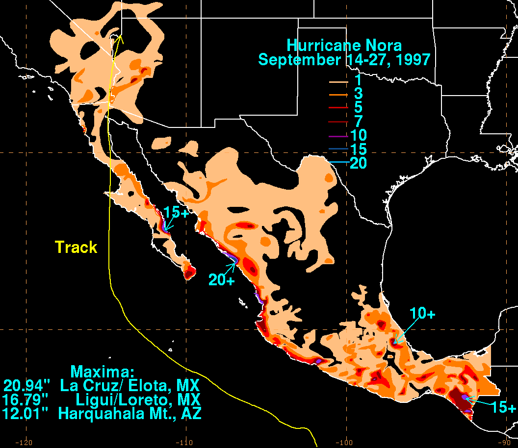
Heavy rains also fell along the storm's northeast periphery, with the highest amounts of 20.94 inches (531.9 mm) falling at La Cruz/Elota and 16.79 inches (426.5 mm) being measured at Ligui/Loreto.
About 350–400 people were left homeless by floodwaters in the town of Arroyo de Santa Catarina in northern Baja California
. Heavy damage and flooding was reported in San Felipe
, on the northwestern shore of the Gulf of California
, as well as extensive beach erosion. Local roads and highways were destroyed and the town's dock was severely damaged. On the northeastern shore, at Puerto Peñasco
, Nora blew down trees, billboards, electric wires, taco stands, and ripped sheet-metal from homes. Waves of 10 feet (3 m) were reported there.
 In the United States, there were no direct deaths blamed on the hurricane. However, the California Highway Patrol
attributed three or four traffic fatalities in southern California
to the weather.
Damage totals in the United States are not fully known, although media summaries of Nora included a loss to agriculture preliminarily estimated at several hundred million dollars, and at least one study places the figure at $150–200 million (1997 USD
). It is estimated that $30–40 million (1997 USD) in damage to lemon trees occurred. Although Nora was significantly weakened, near hurricane-force winds were observed at the Dixie National Forest
in southwestern Utah
, where strong gusts sheared off the tops of large trees.
The Yuma radar indicated a small area of 10 inches (254 mm) rainfall totals along the northern Gulf of California
coast of Baja California. In the United States, the largest total rainfall was recorded at the Harquahala Mountains
in Arizona, where 11.97 inches (304 mm) of rainfall were recorded as a result of Nora, causing flash floods in western Arizona.
Near Phoenix
, rainfall from the storm caused the Narrows Dam, a small earthen dam, to fail. In other locations in Arizona, California, Nevada
, and Utah, more than 3 inches (76.2 mm) occurred in a few localized areas, sometimes with precipitation comparable to the entire local yearly average rainfall. Flooding was also reported in Somerton
, San Diego, El Centro, Palm Springs
and Indio
, while 12,000 people lost power in Yuma, as well as Los Angeles
and southwestern Utah.
Despite the damage, the World Meteorological Organization
did not retire the name Nora during its meeting in the spring of 1998. As a result, it was used in the 2003 Pacific hurricane season
, 2009 Pacific hurricane season
, and is on the list of names to be used in 2015.
Tropical cyclone
A tropical cyclone is a storm system characterized by a large low-pressure center and numerous thunderstorms that produce strong winds and heavy rain. Tropical cyclones strengthen when water evaporated from the ocean is released as the saturated air rises, resulting in condensation of water vapor...
on record to reach Arizona
Arizona
Arizona ; is a state located in the southwestern region of the United States. It is also part of the western United States and the mountain west. The capital and largest city is Phoenix...
as a tropical storm. Nora was the fourteenth named tropical cyclone
Tropical cyclone
A tropical cyclone is a storm system characterized by a large low-pressure center and numerous thunderstorms that produce strong winds and heavy rain. Tropical cyclones strengthen when water evaporated from the ocean is released as the saturated air rises, resulting in condensation of water vapor...
and seventh hurricane of the 1997 Pacific hurricane season
1997 Pacific hurricane season
The 1997 Pacific hurricane season was a very active hurricane season. With hundreds of deaths and billions of dollars in damage, this season was the costliest and one of the deadliest Pacific hurricane seasons. This was due to a strong El Niño...
. The September storm formed off the Pacific
Pacific Ocean
The Pacific Ocean is the largest of the Earth's oceanic divisions. It extends from the Arctic in the north to the Southern Ocean in the south, bounded by Asia and Australia in the west, and the Americas in the east.At 165.2 million square kilometres in area, this largest division of the World...
coast of Mexico
Mexico
The United Mexican States , commonly known as Mexico , is a federal constitutional republic in North America. It is bordered on the north by the United States; on the south and west by the Pacific Ocean; on the southeast by Guatemala, Belize, and the Caribbean Sea; and on the east by the Gulf of...
, and aided by waters warmed by El Niño, eventually peaked at Category 4 intensity on the Saffir-Simpson Hurricane Scale
Saffir-Simpson Hurricane Scale
The Saffir–Simpson Hurricane Scale , or the Saffir–Simpson Hurricane Wind Scale , classifies hurricanes — Western Hemisphere tropical cyclones that exceed the intensities of tropical depressions and tropical storms — into five categories distinguished by the intensities of their sustained winds...
.
Nora intensified and weakened quickly before taking an unusual path, which lead it to make landfall twice as a hurricane in Baja California
Baja California
Baja California officially Estado Libre y Soberano de Baja California is one of the 31 states which, with the Federal District, comprise the 32 Federal Entities of Mexico. It is both the northernmost and westernmost state of Mexico. Before becoming a state in 1953, the area was known as the North...
. After landfall, its remnants affected the Southwestern United States
Southwestern United States
The Southwestern United States is a region defined in different ways by different sources. Broad definitions include nearly a quarter of the United States, including Arizona, California, Colorado, Nevada, New Mexico, Oklahoma, Texas and Utah...
with tropical storm-force winds, torrential rain and flooding. Nora is blamed for two direct casualties in Mexico
Mexico
The United Mexican States , commonly known as Mexico , is a federal constitutional republic in North America. It is bordered on the north by the United States; on the south and west by the Pacific Ocean; on the southeast by Guatemala, Belize, and the Caribbean Sea; and on the east by the Gulf of...
, as well as substantial beach erosion on the Mexican coast, flash flood
Flash flood
A flash flood is a rapid flooding of geomorphic low-lying areas—washes, rivers, dry lakes and basins. It may be caused by heavy rain associated with a storm, hurricane, or tropical storm or meltwater from ice or snow flowing over ice sheets or snowfields...
ing in Baja California, and record precipitation in Arizona
Arizona
Arizona ; is a state located in the southwestern region of the United States. It is also part of the western United States and the mountain west. The capital and largest city is Phoenix...
. Nora persisted far inland and eventually dissipated near the Arizona/Nevada
Nevada
Nevada is a state in the western, mountain west, and southwestern regions of the United States. With an area of and a population of about 2.7 million, it is the 7th-largest and 35th-most populous state. Over two-thirds of Nevada's people live in the Las Vegas metropolitan area, which contains its...
border.
Meteorological history
Nora formed early on September 16, 1997, while located 290 miles (460 km) southwest of the Mexican port of AcapulcoAcapulco
Acapulco is a city, municipality and major sea port in the state of Guerrero on the Pacific coast of Mexico, southwest from Mexico City. Acapulco is located on a deep, semi-circular bay and has been a port since the early colonial period of Mexico’s history...
, Guerrero
Guerrero
Guerrero officially Estado Libre y Soberano de Guerrero is one of the 31 states which, with the Federal District, comprise the 32 Federal Entities of Mexico. It is divided in 81 municipalities and its capital city is Chilpancingo....
, from the same tropical wave
Tropical wave
Tropical waves, easterly waves, or tropical easterly waves, also known as African easterly waves in the Atlantic region, are a type of atmospheric trough, an elongated area of relatively low air pressure, oriented north to south, which move from east to west across the tropics causing areas of...
that had earlier created Hurricane Erika. Due to favorable conditions associated with El Niño, the tropical disturbance quickly achieved deep convection
Convection
Convection is the movement of molecules within fluids and rheids. It cannot take place in solids, since neither bulk current flows nor significant diffusion can take place in solids....
and became well-organized. By 6 a.m. UTC
Coordinated Universal Time
Coordinated Universal Time is the primary time standard by which the world regulates clocks and time. It is one of several closely related successors to Greenwich Mean Time. Computer servers, online services and other entities that rely on having a universally accepted time use UTC for that purpose...
, the U.S. National Hurricane Center
National Hurricane Center
The National Hurricane Center , located at Florida International University in Miami, Florida, is the division of the National Weather Service responsible for tracking and predicting weather systems within the tropics between the Prime Meridian and the 140th meridian west poleward to the 30th...
had designated the disturbance as Tropical Depression Sixteen-E. Half a day later, it had gained enough strength to be named Tropical Storm Nora.
A high pressure area
High pressure area
A high-pressure area is a region where the atmospheric pressure at the surface of the planet is greater than its surrounding environment. Winds within high-pressure areas flow outward due to the higher density air near their center and friction with land...
over northern Mexico forced the storm to move west-northwest for the first few days. During that time, Nora kept intensifying, becoming a Category 1 hurricane on the Saffir-Simpson Hurricane Scale
Saffir-Simpson Hurricane Scale
The Saffir–Simpson Hurricane Scale , or the Saffir–Simpson Hurricane Wind Scale , classifies hurricanes — Western Hemisphere tropical cyclones that exceed the intensities of tropical depressions and tropical storms — into five categories distinguished by the intensities of their sustained winds...
by noon UTC on September 18. Nora slowed and became stationary for two days from September 18. The eye vanished, and convection began to decrease. This was presumed to have happened because of a drop in sea-surface temperatures. The cool waters temporarily weakened Nora's winds to 75 mph (120 km/h) down from a maximum of 105 mph (165 km/h). After leaving the area of cool waters, the storm began moving nearly parallel to Mexico's western coast. There was a period of rapid intensification and the eye reappeared. Cloud tops cooled and at midday UTC on September 21, Nora reached its peak intensity of 950 mbar (28.1 inHg) and 135 mph (210 km/h) winds, a Category 4 hurricane. The peak was brief as the cyclone encountered cool waters in the wake of Hurricane Linda
Hurricane Linda (1997)
Hurricane Linda was the strongest eastern Pacific hurricane on record. Forming from a tropical wave on September 9, 1997, Linda steadily intensified and reached hurricane status within 36 hours of developing. It rapidly intensified, reaching winds of and an estimated central pressure...
, weakening the storm's winds to 80 mph (130 km/h) by September 23 and broke its eyewall.
Baja California Peninsula
The Baja California peninsula , is a peninsula in northwestern Mexico. Its land mass separates the Pacific Ocean from the Gulf of California. The Peninsula extends from Mexicali, Baja California in the north to Cabo San Lucas, Baja California Sur in the south.The total area of the Baja California...
. It restrengthened slightly before making its first landfall near Bahía Tortugas, Baja California Sur
Baja California Sur
Baja California Sur , is one of the 31 states which, with the Federal District, comprise the 32 Federal Entities of Mexico. Before becoming a state on October 8, 1974, the area was known as the South Territory of Baja California. It has an area of , or 3.57% of the land mass of Mexico and comprises...
on September 25. When Nora was inland, the area of the storm located in the Gulf of California
Gulf of California
The Gulf of California is a body of water that separates the Baja California Peninsula from the Mexican mainland...
began to reintensify. Hurricane Nora then made a second landfall about 60 miles (95 km) south-southeast of San Fernando, Baja California
Baja California
Baja California officially Estado Libre y Soberano de Baja California is one of the 31 states which, with the Federal District, comprise the 32 Federal Entities of Mexico. It is both the northernmost and westernmost state of Mexico. Before becoming a state in 1953, the area was known as the North...
.
At landfall, a trough
Trough (meteorology)
A trough is an elongated region of relatively low atmospheric pressure, often associated with fronts.Unlike fronts, there is not a universal symbol for a trough on a weather chart. The weather charts in some countries or regions mark troughs by a line. In the United States, a trough may be marked...
was accelerating Nora northwards, causing it to reach a forward speed of 30 mph (50 km/h). Late on September 25 (UTC), still a tropical storm, it entered the continental United States at the California
California
California is a state located on the West Coast of the United States. It is by far the most populous U.S. state, and the third-largest by land area...
-Arizona
Arizona
Arizona ; is a state located in the southwestern region of the United States. It is also part of the western United States and the mountain west. The capital and largest city is Phoenix...
state line. Nora began to weaken rapidly, and was downgraded to a tropical depression three hours later, while located between Blythe
Blythe, California
Blythe is a city in Riverside County, California, United States, in the "Palo Verde Valley" of the Lower Colorado River Valley region, an agricultural area and part of the Colorado Desert along the Colorado River. Blythe was named after Thomas Blythe, a gold prospector who established primary...
and Needles, California
Needles, California
Needles is a city located in the Mojave Desert on the western banks of the Colorado River in San Bernardino County, California. It is located in the Mohave Valley, which straddles the California–Arizona border. The city is accessible via Interstate 40 and U.S. Route 95...
. Nora reached Arizona
Arizona
Arizona ; is a state located in the southwestern region of the United States. It is also part of the western United States and the mountain west. The capital and largest city is Phoenix...
while still tropical, becoming the third known system to do so. Nora degenerated over land, and the low-level center moved towards the north-northeast. A remnant circulation aloft persisted, however, and was likely responsible for a period of near hurricane-force winds observed at the NWS
National Weather Service
The National Weather Service , once known as the Weather Bureau, is one of the six scientific agencies that make up the National Oceanic and Atmospheric Administration of the United States government...
Cedar City
Cedar City, Utah
As of the census of 2000, there were 20,527 people, 6,486 households, and 4,682 families residing in the city. The population density was 1,021.8 people per square mile . There were 7,109 housing units at an average density of 353.9 per square mile...
, Utah
Utah
Utah is a state in the Western United States. It was the 45th state to join the Union, on January 4, 1896. Approximately 80% of Utah's 2,763,885 people live along the Wasatch Front, centering on Salt Lake City. This leaves vast expanses of the state nearly uninhabited, making the population the...
Doppler weather radar. The remnants gradually became more diffuse over the following two days while moving generally northeastward, through portions of Utah, Colorado
Colorado
Colorado is a U.S. state that encompasses much of the Rocky Mountains as well as the northeastern portion of the Colorado Plateau and the western edge of the Great Plains...
, Idaho
Idaho
Idaho is a state in the Rocky Mountain area of the United States. The state's largest city and capital is Boise. Residents are called "Idahoans". Idaho was admitted to the Union on July 3, 1890, as the 43rd state....
and Wyoming
Wyoming
Wyoming is a state in the mountain region of the Western United States. The western two thirds of the state is covered mostly with the mountain ranges and rangelands in the foothills of the Eastern Rocky Mountains, while the eastern third of the state is high elevation prairie known as the High...
.
Preparations
While Nora stayed off the Pacific coast of Mexico, the Servicio Meteorológico NacionalServicio Meteorológico Nacional
The Servicio Meteorológico Nacional is Mexico's national weather organization. It collects data and issues forecasts, advisories, and warnings for the entire country.-History:...
(National Meteorological Service) issued a hurricane watch for the coast between Lázaro Cárdenas
Lázaro Cárdenas, Michoacán
Lázaro Cárdenas is a port city that with its surrounding municipality is located in the southern part of the Mexican state of Michoacán. It was formerly known as Los Llanitos, but changed its name as a tribute to Lázaro Cárdenas del Río, a Michoacán-born politician who was president of Mexico from...
, Michoacán
Michoacán
Michoacán officially Estado Libre y Soberano de Michoacán de Ocampo is one of the 31 states which, with the Federal District, comprise the 32 Federal Entities of Mexico. It is divided in 113 municipalities and its capital city is Morelia...
, and Puerto Vallarta
Puerto Vallarta
Puerto Vallarta is a Mexican balneario resort city situated on the Pacific Ocean's Bahía de Banderas.The 2010 census reported Puerto Vallarta's population as 255,725 making it the sixth-largest city in the state of Jalisco...
, Jalisco
Jalisco
Jalisco officially Estado Libre y Soberano de Jalisco is one of the 31 states which, with the Federal District, comprise the 32 Federal Entities of Mexico. It is located in Western Mexico and divided in 125 municipalities and its capital city is Guadalajara.It is one of the more important states...
, and several major ports in the shoreline closed to navigation. As the storm moved away from the mainland coast and towards the Baja California Peninsula
Baja California Peninsula
The Baja California peninsula , is a peninsula in northwestern Mexico. Its land mass separates the Pacific Ocean from the Gulf of California. The Peninsula extends from Mexicali, Baja California in the north to Cabo San Lucas, Baja California Sur in the south.The total area of the Baja California...
, about 500 people were evacuated from their homes near Cabo San Lucas
Cabo San Lucas
Cabo San Lucas , commonly called Cabo, is a city at the southern tip of the Baja California peninsula, in the municipality of Los Cabos in the Mexican state of Baja California Sur. As of the 2010 census, the population was 68,463 people...
, Baja California Sur
Baja California Sur
Baja California Sur , is one of the 31 states which, with the Federal District, comprise the 32 Federal Entities of Mexico. Before becoming a state on October 8, 1974, the area was known as the South Territory of Baja California. It has an area of , or 3.57% of the land mass of Mexico and comprises...
, and placed in shelters to prepare for the storm's impact. At the same time, in Sonora
Sonora
Sonora officially Estado Libre y Soberano de Sonora is one of the 31 states which, with the Federal District, comprise the 32 Federal Entities of Mexico. It is divided into 72 municipalities; the capital city is Hermosillo....
, another 50 were evacuated from a fishing camp in Guaymas
Guaymas
Guaymas is a city and municipality located in the southwest part of the state of Sonora in northwestern Mexico. The city is located 117 km south of the state capital of Hermosillo, and 242 miles from the U.S. border, and is the principal port for the state. The municipality is located in the...
. Meanwhile, the SMN issued tropical storm warnings along the Baja California coast, as well as hurricane watches and warnings around the entire Gulf of California between Santa Rosalía
Santa Rosalía, Baja California Sur
Santa Rosalía is a city located on the Baja California peninsula, in the northern part of the Mexican state of Baja California Sur. It was named after Saint Rosalia, although the reason for the name is not quite clear since the Misión de Santa Rosalía is not located by the town, but rather in...
, Baja California Sur
Baja California Sur
Baja California Sur , is one of the 31 states which, with the Federal District, comprise the 32 Federal Entities of Mexico. Before becoming a state on October 8, 1974, the area was known as the South Territory of Baja California. It has an area of , or 3.57% of the land mass of Mexico and comprises...
, and Bahía Kino
Bahía Kino
Bahía Kino is a town in the Mexican state of Sonora, on the Sea of Cortez Gulf of California; it was named after Eusebio Kino. The name also applies to the adjacent bay between Tiburón Island and Punta San Nicolás, Sonora...
, Sonora
Sonora
Sonora officially Estado Libre y Soberano de Sonora is one of the 31 states which, with the Federal District, comprise the 32 Federal Entities of Mexico. It is divided into 72 municipalities; the capital city is Hermosillo....
.
On September 24, Arizona Governor Jane Dee Hull
Jane Dee Hull
Jane Dee Hull was the second woman to serve as Governor of Arizona, the first female Republican governor of the state, and the first woman to be elected to the position.-Biography:...
activated an emergency response center to prepare the state's response to the flash flooding the storm would cause on the dry desert floor, and Yuma
Yuma, Arizona
Yuma is a city in and the county seat of Yuma County, Arizona, United States. It is located in the southwestern corner of the state, and the population of the city was 77,515 at the 2000 census, with a 2008 Census Bureau estimated population of 90,041....
residents began to fill approximately 55,000 sandbags to contain the possible flooding. Hull also activated the state's National Guard
United States National Guard
The National Guard of the United States is a reserve military force composed of state National Guard militia members or units under federally recognized active or inactive armed force service for the United States. Militia members are citizen soldiers, meaning they work part time for the National...
, and sent drinking water
Drinking water
Drinking water or potable water is water pure enough to be consumed or used with low risk of immediate or long term harm. In most developed countries, the water supplied to households, commerce and industry is all of drinking water standard, even though only a very small proportion is actually...
and electric generators to Yuma. Further inland, the National Weather Service
National Weather Service
The National Weather Service , once known as the Weather Bureau, is one of the six scientific agencies that make up the National Oceanic and Atmospheric Administration of the United States government...
issued flash flood
Flash flood
A flash flood is a rapid flooding of geomorphic low-lying areas—washes, rivers, dry lakes and basins. It may be caused by heavy rain associated with a storm, hurricane, or tropical storm or meltwater from ice or snow flowing over ice sheets or snowfields...
watches for western Arizona, southeastern California, southwestern Colorado
Colorado
Colorado is a U.S. state that encompasses much of the Rocky Mountains as well as the northeastern portion of the Colorado Plateau and the western edge of the Great Plains...
, southern Nevada
Nevada
Nevada is a state in the western, mountain west, and southwestern regions of the United States. With an area of and a population of about 2.7 million, it is the 7th-largest and 35th-most populous state. Over two-thirds of Nevada's people live in the Las Vegas metropolitan area, which contains its...
and southern Utah
Utah
Utah is a state in the Western United States. It was the 45th state to join the Union, on January 4, 1896. Approximately 80% of Utah's 2,763,885 people live along the Wasatch Front, centering on Salt Lake City. This leaves vast expanses of the state nearly uninhabited, making the population the...
on September 26.
Impact
Hurricane Nora caused two direct deaths in Mexico and three or four indirect fatalities in the United States. Although the total cost of damage is not known, Nora caused up to several hundred millions of dollars of damage. The system also dropped heavy rain in the United States and Mexico, which caused flooding and power outages.Mexico
Mexicali
Mexicali is the capital of the State of Baja California, seat of the Municipality of Mexicali, and 2nd largest city in Baja California. The City of Mexicali has a population of 689,775, according to the 2010 census, while the population of the entire metropolitan area reaches 936,826.The city...
, Baja California
Baja California
Baja California officially Estado Libre y Soberano de Baja California is one of the 31 states which, with the Federal District, comprise the 32 Federal Entities of Mexico. It is both the northernmost and westernmost state of Mexico. Before becoming a state in 1953, the area was known as the North...
, and a diver caught in strong underwater currents created by Nora off the coast of the San Quintin Valley
San Quintín, Baja California
San Quintín is a coastal town on the west coast of the Mexican state of Baja California, in the municipio of Ensenada. San Quintín has beautiful beaches and several places for tourists to stay. Tourists can enjoy fishing, camping, bird watching, surfing, and clam digging...
.
Although Nora's center of circulation remained well offshore from southwestern mainland Mexico, the Associated Press
Associated Press
The Associated Press is an American news agency. The AP is a cooperative owned by its contributing newspapers, radio and television stations in the United States, which both contribute stories to the AP and use material written by its staff journalists...
reported that waves up to 20 feet (6.1 m) hit that coastline, destroying dozens of homes. Nora's winds also produced rough seas and high waves, which caused substantial beach erosion
Coastal erosion
Coastal erosion is the wearing away of land and the removal of beach or dune sediments by wave action, tidal currents, wave currents, or drainage...
, particularly around Acapulco
Acapulco
Acapulco is a city, municipality and major sea port in the state of Guerrero on the Pacific coast of Mexico, southwest from Mexico City. Acapulco is located on a deep, semi-circular bay and has been a port since the early colonial period of Mexico’s history...
, where the Pie de la Cuesta
Pie de la Cuesta, Guerrero
Pie de la Cuesta is a small beach resort town in the Mexican state of Guerrero, approximately 5 miles north-west of Acapulco, and it is the location of a military base of the Mexican Air Force.- History :...
beaches were washed away. In the states
States of Mexico
The United Mexican States is a federal republic formed by 32 federal entities .According to the Constitution of 1917, the states of the federation are free and sovereign. Each state has their own congress and constitution, while the Federal District has only limited autonomy with a local Congress...
of Guerrero
Guerrero
Guerrero officially Estado Libre y Soberano de Guerrero is one of the 31 states which, with the Federal District, comprise the 32 Federal Entities of Mexico. It is divided in 81 municipalities and its capital city is Chilpancingo....
and Jalisco
Jalisco
Jalisco officially Estado Libre y Soberano de Jalisco is one of the 31 states which, with the Federal District, comprise the 32 Federal Entities of Mexico. It is located in Western Mexico and divided in 125 municipalities and its capital city is Guadalajara.It is one of the more important states...
, Nora brought down trees and washed away the foundations of homes, although no injuries were reported there.
Heavy rains also fell along the storm's northeast periphery, with the highest amounts of 20.94 inches (531.9 mm) falling at La Cruz/Elota and 16.79 inches (426.5 mm) being measured at Ligui/Loreto.
About 350–400 people were left homeless by floodwaters in the town of Arroyo de Santa Catarina in northern Baja California
Baja California
Baja California officially Estado Libre y Soberano de Baja California is one of the 31 states which, with the Federal District, comprise the 32 Federal Entities of Mexico. It is both the northernmost and westernmost state of Mexico. Before becoming a state in 1953, the area was known as the North...
. Heavy damage and flooding was reported in San Felipe
San Felipe, Baja California
San Felipe is a town on the Gulf of California in the Mexican state of Baja California, 190 km south of the United States border and within the municipality of Mexicali. It also serves as a borough seat of its surrouding area....
, on the northwestern shore of the Gulf of California
Gulf of California
The Gulf of California is a body of water that separates the Baja California Peninsula from the Mexican mainland...
, as well as extensive beach erosion. Local roads and highways were destroyed and the town's dock was severely damaged. On the northeastern shore, at Puerto Peñasco
Puerto Peñasco
Puerto Peñasco is a city and municipality located in the northwest of the state of Sonora about 100 km from the Arizona border. It is located on the small strip of land that joins the peninsula of Baja California with the rest of Mexico. The area is part of the Altar Desert, one of the driest...
, Nora blew down trees, billboards, electric wires, taco stands, and ripped sheet-metal from homes. Waves of 10 feet (3 m) were reported there.
United States
California Highway Patrol
The California Highway Patrol is a law enforcement agency of the U.S. state of California. The CHP has patrol jurisdiction over all California highways and also acts as the state police....
attributed three or four traffic fatalities in southern California
California
California is a state located on the West Coast of the United States. It is by far the most populous U.S. state, and the third-largest by land area...
to the weather.
Damage totals in the United States are not fully known, although media summaries of Nora included a loss to agriculture preliminarily estimated at several hundred million dollars, and at least one study places the figure at $150–200 million (1997 USD
United States dollar
The United States dollar , also referred to as the American dollar, is the official currency of the United States of America. It is divided into 100 smaller units called cents or pennies....
). It is estimated that $30–40 million (1997 USD) in damage to lemon trees occurred. Although Nora was significantly weakened, near hurricane-force winds were observed at the Dixie National Forest
Dixie National Forest
Dixie National Forest is a United States National Forest in Utah with headquarters in Cedar City. It occupies almost two million acres and stretches for about 170 miles across southern Utah. The largest national forest in Utah, it straddles the divide between the Great Basin and the Colorado River...
in southwestern Utah
Utah
Utah is a state in the Western United States. It was the 45th state to join the Union, on January 4, 1896. Approximately 80% of Utah's 2,763,885 people live along the Wasatch Front, centering on Salt Lake City. This leaves vast expanses of the state nearly uninhabited, making the population the...
, where strong gusts sheared off the tops of large trees.
The Yuma radar indicated a small area of 10 inches (254 mm) rainfall totals along the northern Gulf of California
Gulf of California
The Gulf of California is a body of water that separates the Baja California Peninsula from the Mexican mainland...
coast of Baja California. In the United States, the largest total rainfall was recorded at the Harquahala Mountains
Harquahala Mountains
The Harquahala Mountains are the highest mountain range in southwestern Arizona, USA and are located southwest of the towns of Aguila and Wenden. The name originated from a local Native American people "Aha qua hala" which meant "water there is high up". The range is oriented from northeast to...
in Arizona, where 11.97 inches (304 mm) of rainfall were recorded as a result of Nora, causing flash floods in western Arizona.
Near Phoenix
Phoenix, Arizona
Phoenix is the capital, and largest city, of the U.S. state of Arizona, as well as the sixth most populated city in the United States. Phoenix is home to 1,445,632 people according to the official 2010 U.S. Census Bureau data...
, rainfall from the storm caused the Narrows Dam, a small earthen dam, to fail. In other locations in Arizona, California, Nevada
Nevada
Nevada is a state in the western, mountain west, and southwestern regions of the United States. With an area of and a population of about 2.7 million, it is the 7th-largest and 35th-most populous state. Over two-thirds of Nevada's people live in the Las Vegas metropolitan area, which contains its...
, and Utah, more than 3 inches (76.2 mm) occurred in a few localized areas, sometimes with precipitation comparable to the entire local yearly average rainfall. Flooding was also reported in Somerton
Somerton, Arizona
Somerton is a city in Yuma County, Arizona, United States. As of the 2010 census the population was 12,014. It is part of the Yuma Metropolitan Statistical Area.Somerton was established in 1898 and incorporated in 1918...
, San Diego, El Centro, Palm Springs
Palm Springs, California
Palm Springs is a desert city in Riverside County, California, within the Coachella Valley. It is located approximately 37 miles east of San Bernardino, 111 miles east of Los Angeles and 136 miles northeast of San Diego...
and Indio
Indio, California
Indio is a city in Riverside County, California, United States, located in the Coachella Valley of Southern California's Colorado Desert region. It lies east of Palm Springs, east of Riverside, and east of Los Angeles. It is about north of Mexicali, Baja California on the U.S.-Mexican border...
, while 12,000 people lost power in Yuma, as well as Los Angeles
Los Ángeles
Los Ángeles is the capital of the province of Biobío, in the commune of the same name, in Region VIII , in the center-south of Chile. It is located between the Laja and Biobío rivers. The population is 123,445 inhabitants...
and southwestern Utah.
Despite the damage, the World Meteorological Organization
World Meteorological Organization
The World Meteorological Organization is an intergovernmental organization with a membership of 189 Member States and Territories. It originated from the International Meteorological Organization , which was founded in 1873...
did not retire the name Nora during its meeting in the spring of 1998. As a result, it was used in the 2003 Pacific hurricane season
2003 Pacific hurricane season
The 2003 Pacific hurricane season produced an unusually large number of tropical cyclones which affected Mexico. The most notable cyclones the year were Hurricanes Ignacio and Marty, which killed 2 and 12 people in Mexico, respectively, and were collectively responsible for about...
, 2009 Pacific hurricane season
2009 Pacific hurricane season
The 2009 Pacific hurricane season was an active event in the annual cycle of tropical cyclone formation, due to a moderate El Niño, unlike the 2009 Atlantic hurricane season, which was relatively quiet. The season officially started on May 15 in the eastern Pacific, and on June 1 for the central...
, and is on the list of names to be used in 2015.
See also
- List of Pacific hurricanes
- List of Arizona hurricanes
- List of California tropical storms
- List of wettest tropical cyclones in Arizona
- Timeline of the 1997 Pacific hurricane seasonTimeline of the 1997 Pacific hurricane seasonThe 1997 Pacific hurricane season was the most active season since the 1994 season, producing 24 tropical depressions, 19 of which became tropical storms or hurricanes. The season officially started on May 15, 1997 in the Eastern Pacific—designated as the area east of 140°W—and on June 1, 1997...