The
Pan-American Highway is a network of
roadA road is a thoroughfare, route, or way on land between two places, which typically has been paved or otherwise improved to allow travel by some conveyance, including a horse, cart, or motor vehicle. Roads consist of one, or sometimes two, roadways each with one or more lanes and also any...
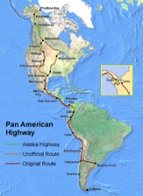
s measuring about 47958 kilometres (29,799.8 mi) in total length. Except for an 87 kilometres (54.1 mi) rainforest break, called the
Darién GapThe Darién Gap is a large swath of undeveloped swampland and forest separating Panama's Darién Province in Central America from Colombia in South America. It measures just over long and about wide. Roadbuilding through this area is expensive, and the environmental toll is steep. Political...
, the road links the mainland nations of the
AmericasThe Americas, or America , are lands in the Western hemisphere, also known as the New World. In English, the plural form the Americas is often used to refer to the landmasses of North America and South America with their associated islands and regions, while the singular form America is primarily...
in a connected highway system. According to
Guinness World RecordsGuinness World Records, known until 2000 as The Guinness Book of Records , is a reference book published annually, containing a collection of world records, both human achievements and the extremes of the natural world...
, the Pan-American Highway is the world's longest "motorable road". However, because of the Darién Gap, it is not possible to cross between South America and Central America by traditional motor vehicle.
The Pan-American Highway system is mostly complete and extends from
Prudhoe Bay, AlaskaPrudhoe Bay or Sagavanirktok is a census-designated place located in North Slope Borough in the U.S. state of Alaska. As of the 2010 census, the population of the CDP was 2,174 people; however, at any given time several thousand transient workers support the Prudhoe Bay oil field...
, in
North AmericaNorth America is a continent wholly within the Northern Hemisphere and almost wholly within the Western Hemisphere. It is also considered a northern subcontinent of the Americas...
to the lower reaches of
South AmericaSouth America is a continent situated in the Western Hemisphere, mostly in the Southern Hemisphere, with a relatively small portion in the Northern Hemisphere. The continent is also considered a subcontinent of the Americas. It is bordered on the west by the Pacific Ocean and on the north and east...
. Several highway termini are claimed to exist, including the cities of
Puerto MonttPuerto Montt is a port city and commune in southern Chile, located at the northern end of the Reloncaví Sound in the Llanquihue Province, Los Lagos Region. The commune spans an area of and had a population of 175,938 in 2002. It is located 1,055 km to the south of the capital, Santiago...
and
QuellónQuellón is a Chilean port city and commune in southern Chiloé Island, Los Lagos Region. It is considered an end-station of the Panamerican Highway and the Pacific Coastal Highway. The majority of men work on small boats called "lanchas" for days at a time fishing...
in
ChileChile ,officially the Republic of Chile , is a country in South America occupying a long, narrow coastal strip between the Andes mountains to the east and the Pacific Ocean to the west. It borders Peru to the north, Bolivia to the northeast, Argentina to the east, and the Drake Passage in the far...
and
UshuaiaUshuaia may refer to the following:*Ushuaia, a city in Argentina.**Ushuaia Department, an administrative division**Ushuaia River**Ushuaia International Airport**Colegio Nacional de Ushuaia, National School of Ushuaia....
in
ArgentinaArgentina , officially the Argentine Republic , is the second largest country in South America by land area, after Brazil. It is constituted as a federation of 23 provinces and an autonomous city, Buenos Aires...
. No comprehensive route is officially defined in
CanadaCanada is a North American country consisting of ten provinces and three territories. Located in the northern part of the continent, it extends from the Atlantic Ocean in the east to the Pacific Ocean in the west, and northward into the Arctic Ocean...
and the
United StatesThe United States of America is a federal constitutional republic comprising fifty states and a federal district...
, though several highways in the U.S. are called "Pan-American".
The Pan-American Highway passes through many diverse climates and ecological types, from dense jungles, to arid deserts, to cold mountain passes. Since the highway passes through many countries, it is far from uniform. Some stretches of the highway are passable only during the dry season, and in many regions driving is occasionally hazardous.
Famous sections of the Pan-American Highway include the
Alaska HighwayThe Alaska Highway was constructed during World War II for the purpose of connecting the contiguous U.S. to Alaska through Canada. It begins at the junction with several Canadian highways in Dawson Creek, British Columbia and runs to Delta Junction, Alaska, via Whitehorse, Yukon...
and the
Inter-American HighwayThe Inter-American Highway is the Central American section of the Pan-American Highway and spans 3,400 miles between Nuevo Laredo, Mexico, and Panama City, Panama....
(the section between the United States and the Panama Canal). Both of these sections were built during World War II as a means of supply of remote areas without danger of attack by
U-boatU-boat is the anglicized version of the German word U-Boot , itself an abbreviation of Unterseeboot , and refers to military submarines operated by Germany, particularly in World War I and World War II...
s.
Jake Silverstein, writing in 2006, described the Pan-American Highway as "a system so vast, so incomplete, and so incomprehensible it is not so much a road as it is the idea of
Pan-Americanism-History:The struggle for independence after 1810 by the Latin American nations evoked a sense of unity, especially in South America where, under Simón Bolívar in the north and José de San Martín in the south, there were cooperative efforts. Francisco Morazán briefly headed a Federal Republic of...
itself…"
Pan-American Highway system overview
The Northern Pan-American Highway travels through 9 countries:
- Canada
Canada is a North American country consisting of ten provinces and three territories. Located in the northern part of the continent, it extends from the Atlantic Ocean in the east to the Pacific Ocean in the west, and northward into the Arctic Ocean...
- United States
The United States of America is a federal constitutional republic comprising fifty states and a federal district...
- Mexico
The United Mexican States , commonly known as Mexico , is a federal constitutional republic in North America. It is bordered on the north by the United States; on the south and west by the Pacific Ocean; on the southeast by Guatemala, Belize, and the Caribbean Sea; and on the east by the Gulf of...
- Guatemala
Guatemala is a country in Central America bordered by Mexico to the north and west, the Pacific Ocean to the southwest, Belize to the northeast, the Caribbean to the east, and Honduras and El Salvador to the southeast...
- El Salvador
El Salvador or simply Salvador is the smallest and the most densely populated country in Central America. The country's capital city and largest city is San Salvador; Santa Ana and San Miguel are also important cultural and commercial centers in the country and in all of Central America...
- Honduras
Honduras is a republic in Central America. It was previously known as Spanish Honduras to differentiate it from British Honduras, which became the modern-day state of Belize...
- Nicaragua
Nicaragua is the largest country in the Central American American isthmus, bordered by Honduras to the north and Costa Rica to the south. The country is situated between 11 and 14 degrees north of the Equator in the Northern Hemisphere, which places it entirely within the tropics. The Pacific Ocean...
- Costa Rica
Costa Rica , officially the Republic of Costa Rica is a multilingual, multiethnic and multicultural country in Central America, bordered by Nicaragua to the north, Panama to the southeast, the Pacific Ocean to the west and the Caribbean Sea to the east....
- Panama
Panama , officially the Republic of Panama , is the southernmost country of Central America. Situated on the isthmus connecting North and South America, it is bordered by Costa Rica to the northwest, Colombia to the southeast, the Caribbean Sea to the north and the Pacific Ocean to the south. The...
The Southern Pan-American Highway travels through 14 countries:
- Suriname
Suriname , officially the Republic of Suriname , is a country in northern South America. It borders French Guiana to the east, Guyana to the west, Brazil to the south, and on the north by the Atlantic Ocean. Suriname was a former colony of the British and of the Dutch, and was previously known as...
- Guyana
Guyana , officially the Co-operative Republic of Guyana, previously the colony of British Guiana, is a sovereign state on the northern coast of South America that is culturally part of the Anglophone Caribbean. Guyana was a former colony of the Dutch and of the British...
- Brazil
Brazil , officially the Federative Republic of Brazil , is the largest country in South America. It is the world's fifth largest country, both by geographical area and by population with over 192 million people...
- Venezuela
Venezuela , officially called the Bolivarian Republic of Venezuela , is a tropical country on the northern coast of South America. It borders Colombia to the west, Guyana to the east, and Brazil to the south...
- Colombia
Colombia, officially the Republic of Colombia , is a unitary constitutional republic comprising thirty-two departments. The country is located in northwestern South America, bordered to the east by Venezuela and Brazil; to the south by Ecuador and Peru; to the north by the Caribbean Sea; to the...
- Ecuador
Ecuador , officially the Republic of Ecuador is a representative democratic republic in South America, bordered by Colombia on the north, Peru on the east and south, and by the Pacific Ocean to the west. It is one of only two countries in South America, along with Chile, that do not have a border...
- Peru
Peru , officially the Republic of Peru , is a country in western South America. It is bordered on the north by Ecuador and Colombia, on the east by Brazil, on the southeast by Bolivia, on the south by Chile, and on the west by the Pacific Ocean....
- Chile
Chile ,officially the Republic of Chile , is a country in South America occupying a long, narrow coastal strip between the Andes mountains to the east and the Pacific Ocean to the west. It borders Peru to the north, Bolivia to the northeast, Argentina to the east, and the Drake Passage in the far...
- Argentina
Argentina , officially the Argentine Republic , is the second largest country in South America by land area, after Brazil. It is constituted as a federation of 23 provinces and an autonomous city, Buenos Aires...
Important spurs also lead into
BoliviaBolivia officially known as Plurinational State of Bolivia , is a landlocked country in central South America. It is the poorest country in South America...
,
ParaguayParaguay , officially the Republic of Paraguay , is a landlocked country in South America. It is bordered by Argentina to the south and southwest, Brazil to the east and northeast, and Bolivia to the northwest. Paraguay lies on both banks of the Paraguay River, which runs through the center of the...
and
UruguayUruguay ,officially the Oriental Republic of Uruguay,sometimes the Eastern Republic of Uruguay; ) is a country in the southeastern part of South America. It is home to some 3.5 million people, of whom 1.8 million live in the capital Montevideo and its metropolitan area...
:
The Pan American Highway goes north out of Mexico into The United States at
Laredo, TexasLaredo is the county seat of Webb County, Texas, United States, located on the north bank of the Rio Grande in South Texas, across from Nuevo Laredo, Tamaulipas, Mexico. According to the 2010 census, the city population was 236,091 making it the 3rd largest on the United States-Mexican border,...
. From there, no official route exists between there and Prudhoe Bay. Stretches of road lay claim to the Pan American Highway in Canada and the United States.
Interstate 35Interstate 35 is a north–south Interstate Highway in the central United States. I-35 stretches from Laredo, Texas, on the U.S.-Mexico border to Duluth, Minnesota, at Minnesota Highway 61 and 26th Avenue East. Many interstates used to have splits or spurs indicated with suffixed letters , but I-35...
is named Pan American Expressway through
San Antonio, TexasSan Antonio is the seventh-largest city in the United States of America and the second-largest city within the state of Texas, with a population of 1.33 million. Located in the American Southwest and the south–central part of Texas, the city serves as the seat of Bexar County. In 2011,...
. The
Pan American Highway Association claims
U.S. Route 81U.S. Route 81 is one of the many United States Numbered Highways established in 1926 by the US Department of Agriculture Bureau of Public Roads....
from
McPherson, KansasMcPherson is a city in and the county seat of McPherson County, Kansas, United States, in the central part of the state. As of the 2010 census, the city population was 13,155. The city is named after Union General James Birdseye McPherson, a Civil War general...
to
Watertown, South DakotaWatertown is a city in and the county seat of Codington County, South Dakota, United States. The population was 21,482 at the 2010 census. It is also the principal city of the Watertown Micropolitan Statistical Area, which includes all of Codington and Hamlin counties...
. The
Alaska HighwayThe Alaska Highway was constructed during World War II for the purpose of connecting the contiguous U.S. to Alaska through Canada. It begins at the junction with several Canadian highways in Dawson Creek, British Columbia and runs to Delta Junction, Alaska, via Whitehorse, Yukon...
through Alaska, the Yukon and northern British Columbia also claims to be part of the Pan American Highway, as well as the
Dalton HighwayThe James W. Dalton Highway, usually Dalton Highway is a 414-mile road in Alaska. It begins at the Elliott Highway, north of Fairbanks, and ends at Deadhorse near the Arctic Ocean and the Prudhoe Bay oil fields...
in Alaska, which is the only road in North America to reach the
Arctic OceanThe Arctic Ocean, located in the Northern Hemisphere and mostly in the Arctic north polar region, is the smallest and shallowest of the world's five major oceanic divisions...
.
Darién Gap
A notable break in the highway is a section of land located in the
Darién ProvinceDarién is a province in eastern Panama. It is also the largest province in Panama. It is hot, humid, heavily forested, and sparsely populated, having 48,378 habitants...
in
PanamaPanama , officially the Republic of Panama , is the southernmost country of Central America. Situated on the isthmus connecting North and South America, it is bordered by Costa Rica to the northwest, Colombia to the southeast, the Caribbean Sea to the north and the Pacific Ocean to the south. The...
and the
ColombiaColombia, officially the Republic of Colombia , is a unitary constitutional republic comprising thirty-two departments. The country is located in northwestern South America, bordered to the east by Venezuela and Brazil; to the south by Ecuador and Peru; to the north by the Caribbean Sea; to the...
n border called the
Darién GapThe Darién Gap is a large swath of undeveloped swampland and forest separating Panama's Darién Province in Central America from Colombia in South America. It measures just over long and about wide. Roadbuilding through this area is expensive, and the environmental toll is steep. Political...
. It is an 87 kilometres (54.1 mi) stretch of
rainforestRainforests are forests characterized by high rainfall, with definitions based on a minimum normal annual rainfall of 1750-2000 mm...
. The gap has been crossed by adventurers on
bicycleA bicycle, also known as a bike, pushbike or cycle, is a human-powered, pedal-driven, single-track vehicle, having two wheels attached to a frame, one behind the other. A person who rides a bicycle is called a cyclist, or bicyclist....
, motorbike,
all-terrain vehicleAn all-terrain vehicle , also known as a quad, quad bike, three wheeler, or four wheeler, is defined by the American National Standards Institute as a vehicle that travels on low pressure tires, with a seat that is straddled by the operator, along with handlebars for steering control...
, and foot, dealing with
jungleA Jungle is an area of land in the tropics overgrown with dense vegetation.The word jungle originates from the Sanskrit word jangala which referred to uncultivated land. Although the Sanskrit word refers to "dry land", it has been suggested that an Anglo-Indian interpretation led to its...
,
swampA swamp is a wetland with some flooding of large areas of land by shallow bodies of water. A swamp generally has a large number of hammocks, or dry-land protrusions, covered by aquatic vegetation, or vegetation that tolerates periodical inundation. The two main types of swamp are "true" or swamp...
,
insectInsects are a class of living creatures within the arthropods that have a chitinous exoskeleton, a three-part body , three pairs of jointed legs, compound eyes, and two antennae...
s, and other hazards.
Many people, groups, indigenous populations, and governments are opposed to completing the Darién portion of the highway. Reasons for opposition include protecting the rain forest, containing the spread of tropical diseases, protecting the livelihood of indigenous peoples in the area, preventing drug trafficking and its associated violence from emanating out of Colombia, and preventing foot and mouth disease from entering North America. The extension of the highway as far as
YavizaYaviza is a town in the Darién Province of Panama. The town marks the northwestern end of the Darién Gap of the Pan-American Highway. It has a population of 1,611 and is the main cultural center of the Panamanian side of the Darién Gap.- Sources :...
resulted in severe deforestation alongside the highway route within a decade.
One option proposed, in a study by Bio-Pacifico, is a short ferry link from Colombia to a new ferry port in Panama, with an extension of the existing Panama highway that would complete the highway without violating these environmental concerns. The ferry would cross the
Gulf of UrabáThe Gulf of Urabá is a gulf on the northern coast of South America. It is part of the Caribbean Sea. It is a long narrow inlet in the coast of Colombia, close to the connection of the continent to the Isthmus of Panama. The town of Turbo lies at the southern end of the Gulf...
from
Turbo, ColombiaTurbo is a port town in Antioquia Department, Colombia. It is located at around . It is located on the coast of Gulf of Urabá, 340 km. north from Medellín...
, to a new Panamanian port (possibly Carreto) connected to a Caribbean coast extension of the highway. Efficient routing would probably dictate that the existing route to Yaviza be relegated to secondary road status.
Development and completion
The concept of a route from one tip of the Americas to the other was originally proposed at the
First Pan-American ConferenceThe First International Conference of American States was held in Washington, D.C., United States, from 20 January to 27 April 1890.-Background to the Conference:...
in 1889 as a railroad; however, nothing ever came of this proposal. The idea of the Pan-American Highway emerged at the Fifth
International Conference of American StatesThe Conferences of American States, commonly referred to as the Pan-American Conferences, were meetings of the Pan-American Union, an international organization for cooperation on trade and other issues. They were first introduced by James G. Blaine of Maine in order to establish closer ties...
in 1923, where it was originally conceived as a single route. The first Pan-American highway conference convened October 5, 1925 in
Buenos AiresBuenos Aires is the capital and largest city of Argentina, and the second-largest metropolitan area in South America, after São Paulo. It is located on the western shore of the estuary of the Río de la Plata, on the southeastern coast of the South American continent...
. Mexico was the first Latin American country to complete its portion of the highway, in 1950.
Brazilian's help in the development of Pan-American Highway.
It was on April 16, 1928 when the “Expedição Brasileira da Estrada Panamericana” began. Suported by president Washington Luis, the expedition sailed from
Rio de JaneiroRio de Janeiro , commonly referred to simply as Rio, is the capital city of the State of Rio de Janeiro, the second largest city of Brazil, and the third largest metropolitan area and agglomeration in South America, boasting approximately 6.3 million people within the city proper, making it the 6th...
, commanded by army lieutenant Leonidas Borges de Oliveira, supported by the observer Francisco Lopes da Cruz and the mechanic Mario Fava, their companions.
These three brave adventurers, driving two "
Ford Model TThe Ford Model T is an automobile that was produced by Henry Ford's Ford Motor Company from September 1908 to May 1927...
" and with a lot of courage, set off to
New YorkNew York is a state in the Northeastern region of the United States. It is the nation's third most populous state. New York is bordered by New Jersey and Pennsylvania to the south, and by Connecticut, Massachusetts and Vermont to the east...
with a mission to map and, since then, designing the road that, in future, would be the highway that would link the three Americas: Pan-American Highway.
The initiative was successful ten years after its inception (1928-1938), when the three Brazilians arrived in New York, United States, the last city to be visited before returning to
BrazilBrazil , officially the Federative Republic of Brazil , is the largest country in South America. It is the world's fifth largest country, both by geographical area and by population with over 192 million people...
. Throughout all the journey, the expedition covered 28,000 km of roads and unknown ways, past fifteen countries and facing, with shovels, picks, dynamite and the dream of find a place in history, forests, jungles, wild rivers and even the imposing Andes.
In numerous parades, the three adventurers met historical figures of the Americas, as Untouchable
Eliot NessEliot Ness was an American Prohibition agent, famous for his efforts to enforce Prohibition in Chicago, Illinois, and the leader of a legendary team of law enforcement agents nicknamed The Untouchables.- Early life :...
, the revolutionary nicaraguan Augusto Cesar Sandino, the U.S. President Franklin Delano Roosevelt and the pioneer of the automobile industry,
Henry FordHenry Ford was an American industrialist, the founder of the Ford Motor Company, and sponsor of the development of the assembly line technique of mass production. His introduction of the Model T automobile revolutionized transportation and American industry...
, among many others.
Leonidas Borges, Francisco Lopes and Mario Fava exceeded hundreds of obstacles to overcome to continue the dream Panamericano. After the trip, the construction of passages that there was not yet complete, with the exception of mileage located in Brazil, however, the story of these noble heroes is still unknown to many people of our country.
Northern section of the Pan-American Highway
No single road in the U.S. or Canada has been officially or unofficially designated as the Pan-American Highway. In 1966, the
Federal Highway AdministrationThe Federal Highway Administration is a division of the United States Department of Transportation that specializes in highway transportation. The agency's major activities are grouped into two "programs," the Federal-aid Highway Program and the Federal Lands Highway Program...
designated the entire
Interstate Highway SystemThe Dwight D. Eisenhower National System of Interstate and Defense Highways, , is a network of limited-access roads including freeways, highways, and expressways forming part of the National Highway System of the United States of America...
as part of the Pan-American Highway System.
Thus the primary road officially starts at the U.S.-Mexico border. The original route began at the border at Nuevo Laredo, Tamaulipas (opposite
Laredo, TexasLaredo is the county seat of Webb County, Texas, United States, located on the north bank of the Rio Grande in South Texas, across from Nuevo Laredo, Tamaulipas, Mexico. According to the 2010 census, the city population was 236,091 making it the 3rd largest on the United States-Mexican border,...
) and went south through
Mexico CityMexico City is the Federal District , capital of Mexico and seat of the federal powers of the Mexican Union. It is a federal entity within Mexico which is not part of any one of the 31 Mexican states but belongs to the federation as a whole...
. Later branches were built to the border at
Nogales, SonoraHeroica Nogales , more commonly known as Nogales, is a city and its surrounding municipality on the northern border of the Mexican State of Sonora. The municipality covers an area of 1,675 km², and borders to the north the city of Nogales, Arizona, United States, across the U.S.-Mexico border...
(
Nogales, ArizonaNogales is a city in Santa Cruz County, Arizona, United States. The population was 21,017 at the 2010 census. According to 2005 Census Bureau estimates, the population of the city is 20,833. The city is the county seat of Santa Cruz County....
); Ciudad Juárez, Chihuahua (
El Paso, TexasEl Paso, is a city in and the county seat of El Paso County, Texas, United States, and lies in far West Texas. In the 2010 census, the city had a population of 649,121. It is the sixth largest city in Texas and the 19th largest city in the United States...
);
Piedras Negras, Coahuila-Natural Resources:This region generates a large amount of the national production of coal, one of the most economically important non-metallic minerals in the state.-Tourism:Piedras Negras' main tourist attractions are:...
(
Eagle Pass, TexasEagle Pass is a city in and the county seat of Maverick County The population was 27,183 as of the 2010 census.Eagle Pass borders the city of Piedras Negras, Coahuila, Mexico, which is to the southwest and across the Rio Grande. The Eagle Pass-Piedras Negras Metropolitan Area is one of six...
); Reynosa, Tamaulipas (
Pharr, TexasPharr is a city in Hidalgo County, Texas, United States. As of the 2010 census, the city population was 70,400. Pharr is connected by bridge to the Mexican city of Reynosa, Tamaulipas...
); and
Matamoros, TamaulipasMatamoros, officially known as Heroica Matamoros, is a city in the northeastern part of Tamaulipas, in the country of Mexico. It is located on the southern bank of the Rio Grande, directly across the border from Brownsville, Texas, in the United States. Matamoros is the second largest and second...
(
Brownsville, TexasBrownsville is a city in the southernmost tip of the state of Texas, in the United States. It is located on the northern bank of the Rio Grande, directly north and across the border from Matamoros, Tamaulipas, Mexico. Brownsville is the 16th largest city in the state of Texas with a population of...
).
On the other hand, several roads in the U.S. were locally named after the Pan-American Highway. When the section of
Interstate 35Interstate 35 is a north–south Interstate Highway in the central United States. I-35 stretches from Laredo, Texas, on the U.S.-Mexico border to Duluth, Minnesota, at Minnesota Highway 61 and 26th Avenue East. Many interstates used to have splits or spurs indicated with suffixed letters , but I-35...
in
San Antonio, TexasSan Antonio is the seventh-largest city in the United States of America and the second-largest city within the state of Texas, with a population of 1.33 million. Located in the American Southwest and the south–central part of Texas, the city serves as the seat of Bexar County. In 2011,...
was built, it was named the Pan Am Expressway, as an extension of the original route from Laredo.
Interstate 25Interstate 25 is an Interstate Highway in the western United States. It is primarily a north–south highway. I-25 stretches from Interstate 10 at Las Cruces, New Mexico, , to Interstate 90 in Buffalo, Wyoming, .Interstate 25 is the main north–south expressway through...
in
Albuquerque, New MexicoAlbuquerque is the largest city in the state of New Mexico, United States. It is the county seat of Bernalillo County and is situated in the central part of the state, straddling the Rio Grande. The city population was 545,852 as of the 2010 Census and ranks as the 32nd-largest city in the U.S. As...
has been named the Pan-American Freeway, as an extension of the route to El Paso.
U.S. Route 85U.S. Route 85 is a north–south United States highway that runs for in the Mountain - Northern Plains states of the United States. The southern terminus of the route is at the United States-Mexico border in El Paso, Texas, connecting with Mexican Federal Highway 45...
, which goes north from El Paso, is designated the
CanAm HighwayCanAm Highway passes through these states in the United States; Texas, New Mexico, Colorado, Wyoming, South Dakota, North Dakota, as well as the province of Saskatchewan, Canada. The international Can-Am Highway travels along U.S. Route 85 and Interstate 25, connecting Mexico to Canada through...
, which continues into Canada in the province of
SaskatchewanSaskatchewan is a prairie province in Canada, which has an area of . Saskatchewan is bordered on the west by Alberta, on the north by the Northwest Territories, on the east by Manitoba, and on the south by the U.S. states of Montana and North Dakota....
, before terminating at
La RongeLa Ronge is a community of about 2,700 people in Northern Saskatchewan, Canada, 250 km north of Prince Albert. There are an additional 2,000 people living in the Lac La Ronge First Nation bordering the town, and another 1,000 people living in the neighbouring community of Air Ronge...
. The
CANAMEX CorridorThe CANAMEX corridor is a corridor linking Canada to Mexico through the United States. The corridor was established under the North American Free Trade Agreement.Currently the corridor is defined by a series of highways...
is also similarly designated throughout the western United States, and continuing into the Canadian province of
AlbertaAlberta is a province of Canada. It had an estimated population of 3.7 million in 2010 making it the most populous of Canada's three prairie provinces...
. Finally,
Interstate 69Interstate 69 is an Interstate Highway in the United States. It exists in two parts: a completed highway from Indianapolis, Indiana, northeast to the Canadian border in Port Huron, Michigan, and a mostly proposed extension southwest to the Mexican border in Texas...
from the Canadian Border at
Port Huron, MichiganPort Huron is a city in the U.S. state of Michigan and the county seat of St. Clair County. The population was 30,184 at the 2010 census. The city is adjacent to Port Huron Township but is administratively autonomous. It is joined by the Blue Water Bridge over the St. Clair River to Sarnia,...
to
Indianapolis, IndianaIndianapolis is the capital of the U.S. state of Indiana, and the county seat of Marion County, Indiana. As of the 2010 United States Census, the city's population is 839,489. It is by far Indiana's largest city and, as of the 2010 U.S...
, and its planned extension southward to the Mexican Border at
Laredo, TexasLaredo is the county seat of Webb County, Texas, United States, located on the north bank of the Rio Grande in South Texas, across from Nuevo Laredo, Tamaulipas, Mexico. According to the 2010 census, the city population was 236,091 making it the 3rd largest on the United States-Mexican border,...
has been designated as the
NAFTA SuperhighwayThe NAFTA superhighway is a term sometimes used to refer to certain existing and proposed highways. The beliefs associated with this appellation have been characterized as a part of theories of a conspiracy to undermine U.S...
along with Ontario Highway 402 in Canada. When completed, I-69 will connect with an official branch of the Pan-Am Highway at the
LaredoLaredo is the county seat of Webb County, Texas, United States, located on the north bank of the Rio Grande in South Texas, across from Nuevo Laredo, Tamaulipas, Mexico. According to the 2010 census, the city population was 236,091 making it the 3rd largest on the United States-Mexican border,...
-Nuevo Laredo border crossing.
Between
Nuevo LaredoNuevo Laredo is a city located in the Municipality of Nuevo Laredo in the Mexican state of Tamaulipas. The city lies on the banks of the Río Grande, across from the United States city of Laredo, Texas. The 2010 census population of the city was 373,725. Nuevo Laredo is part of the Laredo-Nuevo...
,
MexicoThe United Mexican States , commonly known as Mexico , is a federal constitutional republic in North America. It is bordered on the north by the United States; on the south and west by the Pacific Ocean; on the southeast by Guatemala, Belize, and the Caribbean Sea; and on the east by the Gulf of...
, and
Panama CityPanama is the capital and largest city of the Republic of Panama. It has a population of 880,691, with a total metro population of 1,272,672, and it is located at the Pacific entrance of the Panama Canal, in the province of the same name. The city is the political and administrative center of the...
,
PanamaPanama , officially the Republic of Panama , is the southernmost country of Central America. Situated on the isthmus connecting North and South America, it is bordered by Costa Rica to the northwest, Colombia to the southeast, the Caribbean Sea to the north and the Pacific Ocean to the south. The...
, the route is known as the
Inter-American HighwayThe Inter-American Highway is the Central American section of the Pan-American Highway and spans 3,400 miles between Nuevo Laredo, Mexico, and Panama City, Panama....
, and more specifically, in the
Central AmericaCentral America is the central geographic region of the Americas. It is the southernmost, isthmian portion of the North American continent, which connects with South America on the southeast. When considered part of the unified continental model, it is considered a subcontinent...
n countries, it is known as the CA-1 (Central America 1).
Mexico
The original route to Laredo travels up
Mexican Federal Highway 85Mexico's Federal Highway 85 connects Mexico City with the U.S. border at Nuevo Laredo, Tamaulipas. It is the original route of the Inter-American Highway. Highway 85 runs through Monterrey, Nuevo León; Ciudad Victoria, Tamaulipas; Ciudad Valles, San Luis Potosí; and Pachuca, Hidalgo...
from Mexico City. The various spurs follow:
- Nogales spur - Mexican Federal Highway 15
Federal Highway 15 is a primary north-south highway in Mexico. The highway begins in the north at the United States-Mexico border at the Mariposa Port of Entry in Nogales, Sonora, and terminates to the south in Mexico City...
from Mexico City
- El Paso spur - Mexican Federal Highway 45
Mexican Federal Highway 45 connects Ciudad Juárez, Chihuahua, to Panales, Hidalgo.It is located in the north of Mexico connecting Portezuelo in Hidalgo to Ciudad Juárez in Chihuahua...
from Mexico City
- Eagle Pass spur - unknown, possibly Mexican Federal Highway 57
Mexican Federal Highway 57 is a Federal Highway of Mexico.The 1248 kilometre highway connects Mexico City with Piedras Negras, Coahuila. This road links many major highways in the country, forming the backbone of the road network in Mexico...
from Mexico City
- Pharr spur - Mexican Federal Highway 40
Mexican Federal Highway 40, also called the "Carretera Interoceánica" is a road beginning at Reynosa, Tamaulipas, and ending at Mazatlán, Sinaloa, at the Pacific coast...
from Monterrey
- Brownsville spur - Mexican Federal Highway 101
Mexican Federal Highway 101 connects Matamoros, Tamaulipas, to Mexican Federal Highway 80 in San Luis Potosí.It passes through Victoria, the capital of Tamaulipas, and Tula. The route traverses the Sierra Madre Oriental cordillera....
from Ciudad Victoria
From Mexico City to the border with
GuatemalaGuatemala is a country in Central America bordered by Mexico to the north and west, the Pacific Ocean to the southwest, Belize to the northeast, the Caribbean to the east, and Honduras and El Salvador to the southeast...
, the Highway follows
Mexican Federal Highway 190Mexican Federal Highway 190 is a Federal Highway of Mexico....
.
Central America
It passes through the
Central AmericaCentral America is the central geographic region of the Americas. It is the southernmost, isthmian portion of the North American continent, which connects with South America on the southeast. When considered part of the unified continental model, it is considered a subcontinent...
n countries with the highway designation of CA-1 (Central American Highway 1). In
GuatemalaGuatemala is a country in Central America bordered by Mexico to the north and west, the Pacific Ocean to the southwest, Belize to the northeast, the Caribbean to the east, and Honduras and El Salvador to the southeast...
, it passes through 10
departments||Guatemala is divided into 22 departments :#Alta Verapaz#Baja Verapaz#Chimaltenango#Chiquimula#Petén#El Progreso#El Quiché#Escuintla#Guatemala#Huehuetenango#Izabal#Jalapa#Jutiapa#Quetzaltenango#Retalhuleu#Sacatepéquez...
, including Guatemala, where it passes through
Guatemala CityGuatemala City , is the capital and largest city of the Republic of Guatemala and Central America...
. In El Salvador, it passes through the cities of
Santa AnaSanta Ana is the second largest city in El Salvador, located 64 kilometers west of San Salvador, the capital city. Santa Ana has approximately 274,830 inhabitants and serves both as the capital of the department of Santa Ana and...
,
Santa TeclaSanta Tecla may mean:* A saint: see Thecla* Santa Tecla, El Salvador, formerly named Nueva San Salvador...
,
Antiguo CuscatlanAntiguo Cuscatlán is a municipality in the La Libertad department of El Salvador, southwest of San Salvador and to the east of Santa Tecla. Antiguo Cuscatlán is considered the richest and most urban municipality inside the "Metropolitan Area of San Salvador" as well as in the whole country.It...
,
San SalvadorThe city of San Salvador the capital and largest city of El Salvador, which has been designated a Gamma World City. Its complete name is La Ciudad de Gran San Salvador...
,
San MartinSan Martín is a municipality in the San Salvador department of El Salvador....
,
San MiguelSan Miguel is the fourth most populous city in El Salvador after Santa Ana and Soyapango and the second most important after San Salvador. It is located 138 km east of the capital, San Salvador. It is also the capital of the department of San Miguel and a municipality...
, and crosses the border into Honduras at Amatillo. From Honduras, it passes into Nicaragua, passing though the Nicaraguan cities of
ChinandegaChinandega is a town and the departmental seat of Chinandega department in Nicaragua. It is also the administrative centre of the surrounding municipality of the same name. The city has a population of 121,793 inhabitants with 151,000 in the municipality...
,
LeónLeón is a department in northwestern Nicaragua . It is also the second largest city in Nicaragua, after Managua. It was founded by the Spaniards as Santiago de los Caballeros de León and rivals Granada, Nicaragua, in the number of historic Spanish colonial homes and churches...
, and
ManaguaManagua is the capital city of Nicaragua as well as the department and municipality by the same name. It is the largest city in Nicaragua in terms of population and geographic size. Located on the southwestern shore of Lake Xolotlán or Lake Managua, the city was declared the national capital in...
, before entering Costa Rica at Peñas Blancas. In Costa Rica, it passes through
LiberiaLiberia is the capital and largest city of Guanacaste province, Costa Rica, located northwest of the national capital, San José.-Summary:With more than 35,000 inhabitants, Liberia is the regional hub of the Costa Rican northwest. The city center features a modern church, as many Costa Rican towns...
,
San JoséSan José is the capital and largest city of Costa Rica. Located in the Central Valley, San José is the seat of national government, the focal point of political and economic activity, and the major transportation hub of this Central American nation.Founded in 1738 by order of Cabildo de León, San...
,
Cartago- See also :* Cartago Agrarian Union Party* Provincial Integration Party Three* Cartago in Spanish...
, Pérez Zeledón, Palmares, Neily, before crossing into Panama at Paso Canoas. In Panama, it crosses the
Panama CanalThe Panama Canal is a ship canal in Panama that joins the Atlantic Ocean and the Pacific Ocean and is a key conduit for international maritime trade. Built from 1904 to 1914, the canal has seen annual traffic rise from about 1,000 ships early on to 14,702 vessels measuring a total of 309.6...
, and ends at Yaviza, Panama at the edge of the
Darién GapThe Darién Gap is a large swath of undeveloped swampland and forest separating Panama's Darién Province in Central America from Colombia in South America. It measures just over long and about wide. Roadbuilding through this area is expensive, and the environmental toll is steep. Political...
. The road had formerly ended at Cañita, Panama, 110 miles (177 km) north of its current end. United States government funding was particularly significant to complete a high-level bridge over the
Panama CanalThe Panama Canal is a ship canal in Panama that joins the Atlantic Ocean and the Pacific Ocean and is a key conduit for international maritime trade. Built from 1904 to 1914, the canal has seen annual traffic rise from about 1,000 ships early on to 14,702 vessels measuring a total of 309.6...
, during the years when the canal was administered by the United States.
Southern section of the Pan-American Highway
The southern part of the highway begins in northwestern Colombia, from where it follows Colombia Highway 62 to
MedellínMedellín , officially the Municipio de Medellín or Municipality of Medellín, is the second largest city in Colombia. It is in the Aburrá Valley, one of the more northerly of the Andes in South America. It has a population of 2.3 million...
. At Medellín, Colombia Highway 54 leads to
BogotáBogotá, Distrito Capital , from 1991 to 2000 called Santa Fé de Bogotá, is the capital, and largest city, of Colombia. It is also designated by the national constitution as the capital of the department of Cundinamarca, even though the city of Bogotá now comprises an independent Capital district...
, but Colombia Highway 25 turns south for a more direct route. Colombia Highway 72 is routed southwest from Bogotá to join Highway 25 at Murillo. Highway 25 continues all the way to the border with Ecuador.
Ecuador Highway 35Ecuador Highway 35 , officially named "Troncal de la Sierra" but colloquially known as "La Panamericana", is a primary highway in Ecuador. This road is Ecuador's portion of the Pan-American Highway...
runs the whole length of that country.
Peru Highway 1Peru Highway 1, most widely known as Carretera Panamericana, is the most important highway in Peru.This road is the Peruvian portion of the Pan-American Highway...
carries the Pan-American Highway all the way through Peru to the border with Chile.
In
ChileChile ,officially the Republic of Chile , is a country in South America occupying a long, narrow coastal strip between the Andes mountains to the east and the Pacific Ocean to the west. It borders Peru to the north, Bolivia to the northeast, Argentina to the east, and the Drake Passage in the far...
, the highway follows
Chile Highway 5Chile Highway 5 or Route 5 known locally as Ruta 5 is Chile's longest route. It is part of the Panamerican Highway.-Stretch:It runs from the Peruvian border connecting with Peru Highway 1 north of Arica to Puerto Montt where it connects by ferry to the island of Chiloé...
south to a point north of
SantiagoSantiago , also known as Santiago de Chile, is the capital and largest city of Chile, and the center of its largest conurbation . It is located in the country's central valley, at an elevation of above mean sea level...
(Llaillay), where the highway splits into two parts, one of which goes through Chilean territory to
QuellónQuellón is a Chilean port city and commune in southern Chiloé Island, Los Lagos Region. It is considered an end-station of the Panamerican Highway and the Pacific Coastal Highway. The majority of men work on small boats called "lanchas" for days at a time fishing...
on
Chiloé IslandChiloé Island , also known as Greater Island of Chiloé , is the largest island of the Chiloé Archipelago off the coast of Chile, in the Pacific Ocean...
, after which it continues as the
Carretera AustralThe Carretera Austral , formerly known as Carretera General Augusto Pinochet, is the name given to Chile's Route 7. The highway runs about from Puerto Montt to Villa O'Higgins through rural Patagonia....
. The other part goes east along Chile Highway 60, which becomes
Argentina National Route 7National Route 7 is a road in Argentina. It crosses the country from east to west, from the capital to the border with Chile, thus linking the Atlantic coast with the Andes, crossing the provinces of Buenos Aires, Santa Fe, Córdoba, San Luis and Mendoza...
at the Argentinian border and continues to
Buenos AiresBuenos Aires is the capital and largest city of Argentina, and the second-largest metropolitan area in South America, after São Paulo. It is located on the western shore of the estuary of the Río de la Plata, on the southeastern coast of the South American continent...
, the end of the main highway. The highway network also continues south of
Buenos AiresBuenos Aires is the capital and largest city of Argentina, and the second-largest metropolitan area in South America, after São Paulo. It is located on the western shore of the estuary of the Río de la Plata, on the southeastern coast of the South American continent...
along
Argentina National Route 3Ruta Nacional 3 is an Argentine highway, stretching from the eastern side of the country in Buenos Aires, crossing the provinces of Buenos Aires, Río Negro, Chubut Province, Santa Cruz and Tierra del Fuego...
towards the city of
UshuaiaUshuaia may refer to the following:*Ushuaia, a city in Argentina.**Ushuaia Department, an administrative division**Ushuaia River**Ushuaia International Airport**Colegio Nacional de Ushuaia, National School of Ushuaia....
in
Tierra del FuegoTierra del Fuego is an archipelago off the southernmost tip of the South American mainland, across the Strait of Magellan. The archipelago consists of a main island Isla Grande de Tierra del Fuego divided between Chile and Argentina with an area of , and a group of smaller islands including Cape...
.
One branch, known as the Simón Bolívar Highway, runs from
BogotáBogotá, Distrito Capital , from 1991 to 2000 called Santa Fé de Bogotá, is the capital, and largest city, of Colombia. It is also designated by the national constitution as the capital of the department of Cundinamarca, even though the city of Bogotá now comprises an independent Capital district...
(Colombia) to Guiria (Venezuela). It begins by using Colombia Highway 71 all the way to the border with Venezuela. From there it uses Venezuela Highway 1 to
CaracasCaracas , officially Santiago de León de Caracas, is the capital and largest city of Venezuela; natives or residents are known as Caraquenians in English . It is located in the northern part of the country, following the contours of the narrow Caracas Valley on the Venezuelan coastal mountain range...
and Venezuela Highway 9 to its end at Guiria.
A continuation of the Pan-American Highway to the
BrazilBrazil , officially the Federative Republic of Brazil , is the largest country in South America. It is the world's fifth largest country, both by geographical area and by population with over 192 million people...
ian cities of
São PauloSão Paulo is the largest city in Brazil, the largest city in the southern hemisphere and South America, and the world's seventh largest city by population. The metropolis is anchor to the São Paulo metropolitan area, ranked as the second-most populous metropolitan area in the Americas and among...
and
Rio de JaneiroRio de Janeiro , commonly referred to simply as Rio, is the capital city of the State of Rio de Janeiro, the second largest city of Brazil, and the third largest metropolitan area and agglomeration in South America, boasting approximately 6.3 million people within the city proper, making it the 6th...
uses a ferry from
Buenos AiresBuenos Aires is the capital and largest city of Argentina, and the second-largest metropolitan area in South America, after São Paulo. It is located on the western shore of the estuary of the Río de la Plata, on the southeastern coast of the South American continent...
to Colonia in
UruguayUruguay ,officially the Oriental Republic of Uruguay,sometimes the Eastern Republic of Uruguay; ) is a country in the southeastern part of South America. It is home to some 3.5 million people, of whom 1.8 million live in the capital Montevideo and its metropolitan area...
and Uruguay Highway 1 to
MontevideoMontevideo is the largest city, the capital, and the chief port of Uruguay. The settlement was established in 1726 by Bruno Mauricio de Zabala, as a strategic move amidst a Spanish-Portuguese dispute over the platine region, and as a counter to the Portuguese colony at Colonia del Sacramento...
. Uruguay Highway 9 and Brazil Highway 471 route to near Pelotas, from where Brazil Highway 116 leads to Brazilian main cities.
Another branch, from Buenos Aires to
AsunciónAsunción is the capital and largest city of Paraguay.The "Ciudad de Asunción" is an autonomous capital district not part of any department. The metropolitan area, called Gran Asunción, includes the cities of San Lorenzo, Fernando de la Mora, Lambaré, Luque, Mariano Roque Alonso, Ñemby, San...
in
ParaguayParaguay , officially the Republic of Paraguay , is a landlocked country in South America. It is bordered by Argentina to the south and southwest, Brazil to the east and northeast, and Bolivia to the northwest. Paraguay lies on both banks of the Paraguay River, which runs through the center of the...
, heads out of
Buenos AiresBuenos Aires is the capital and largest city of Argentina, and the second-largest metropolitan area in South America, after São Paulo. It is located on the western shore of the estuary of the Río de la Plata, on the southeastern coast of the South American continent...
on
Argentina National Route 9National Route 9 is a major road in Argentina, which runs from the center-east to the northwest of the country, crossing the provinces of Buenos Aires, Santa Fe, Córdoba, Santiago del Estero, Tucumán, Salta and Jujuy...
. It switches to Argentina National Route 11 at
RosarioRosario is the largest city in the province of Santa Fe, Argentina. It is located northwest of Buenos Aires, on the western shore of the Paraná River and has 1,159,004 residents as of the ....
, which crosses the border with Paraguay right at Asunción. Other branches probably exist across the center of South America.
The highway does not have official segments to
BelizeBelize is a constitutional monarchy and the northernmost country in Central America. Belize has a diverse society, comprising many cultures and languages. Even though Kriol and Spanish are spoken among the population, Belize is the only country in Central America where English is the official...
,
GuyanaGuyana , officially the Co-operative Republic of Guyana, previously the colony of British Guiana, is a sovereign state on the northern coast of South America that is culturally part of the Anglophone Caribbean. Guyana was a former colony of the Dutch and of the British...
,
SurinameSuriname , officially the Republic of Suriname , is a country in northern South America. It borders French Guiana to the east, Guyana to the west, Brazil to the south, and on the north by the Atlantic Ocean. Suriname was a former colony of the British and of the Dutch, and was previously known as...
and
French GuianaFrench Guiana is an overseas region of France, consisting of a single overseas department located on the northern Atlantic coast of South America. It has borders with two nations, Brazil to the east and south, and Suriname to the west...
, nor to any of the island nations in the Americas. However, highways from Venezuela link to Brazilian
Trans-Amazonian highwayThe Trans-Amazonian Highway , was inaugurated on August 30, 1972. It is 5,300 km long, making it the third longest highway in Brazil...
that provide a southwest entrance to Guyana, route to the coast, and follow a coastal route through Suriname to French Guiana. Belize was supposedly included in the route at one time, as they switched which side of the road they drive on. As British Honduras, they were the only Central American country to drive on the left side of the road.
Art and culture
The Pan-American highway is the subject of a 2006 conceptual art piece,
The School of Panamerican UnrestThe School of Panamerican Unrest is a conceptual art project led by Mexican artist Pablo Helguera. The project involves a series of performances, discussions and screenings to seek connections between the different regions of the Americas. The core of the project consisted of a travelling...
, where Mexican-born artist Pablo Helguera is attempting to drive a portable schoolhouse for the length of the entire route.
The travel writer
Tim CahillTim Cahill is a travel writer who lives in Livingston, Montana, United States. He is a founding editor of Outside magazine and currently serves as an "Editor at Large" for the magazine.-Biography:...
wrote a book,
Road Fever, about his record-setting 24-day drive from
UshuaiaUshuaia may refer to the following:*Ushuaia, a city in Argentina.**Ushuaia Department, an administrative division**Ushuaia River**Ushuaia International Airport**Colegio Nacional de Ushuaia, National School of Ushuaia....
in the Argentine province of Tierra del Fuego to Prudhoe Bay in the U.S. state of
AlaskaAlaska is the largest state in the United States by area. It is situated in the northwest extremity of the North American continent, with Canada to the east, the Arctic Ocean to the north, and the Pacific Ocean to the west and south, with Russia further west across the Bering Strait...
with professional long-distance driver Garry Sowerby, much of their route following the Pan-American Highway.
In the British motoring show
Top Gear, the presenters drove on a section of the road in their off-road vehicles in the Bolivian Special.
In 2003, Kevin Sanders, a long-distance rider, broke the
Guinness World RecordGuinness World Records, known until 2000 as The Guinness Book of Records , is a reference book published annually, containing a collection of world records, both human achievements and the extremes of the natural world...
for the fastest traversal of the highway by
motorcycleA motorcycle is a single-track, two-wheeled motor vehicle. Motorcycles vary considerably depending on the task for which they are designed, such as long distance travel, navigating congested urban traffic, cruising, sport and racing, or off-road conditions.Motorcycles are one of the most...
in 34 days.
See also
- CANAMEX Corridor
The CANAMEX corridor is a corridor linking Canada to Mexico through the United States. The corridor was established under the North American Free Trade Agreement.Currently the corridor is defined by a series of highways...
- Trans-Siberian Highway
The Trans-Siberian Highway is the unofficial name for a network of federal highways that span the width of Russia from the Baltic Sea of the Atlantic Ocean to the Japan Sea of the Pacific Ocean. In the Asian Highway Network, the route is known as AH6. It stretches over from St. Petersburg to...
- Panamericana
Panamericana is a 2010 documentary about the life at the longest road on Earth: a road-trip from Mexico to Argentina through 12 countries and for 13,000 kilometers.-Plot:...
(Documentary, 2010)
Sources
- Plan Federal Highway System, New York Times May 15, 1932 page XX7
- Reported from the Motor World, New York Times January 26, 1936 page XX6
- Hemisphere Road is Nearer Reality, New York Times January 7, 1953 page 58
- 1997-98 AAA
AAA , formerly known as the American Automobile Association, is a federation of 51 independently operated motor clubs throughout North America. AAA is a not-for-profit member service organization with more than 51 million members. AAA provides services to its members such as travel, automotive,...
Caribbean, Central America and South America map
- Popular Mechanics, March 1943, Longest Road In The World