

White Sea
Encyclopedia
The White Sea is a southern inlet
of the Barents Sea
located on the northwest coast of Russia
. It is surrounded by Karelia
to the west, the Kola Peninsula
to the north, and the Kanin Peninsula
to the northeast. The whole of the White Sea is under Russian sovereignty and considered to be part of the internal waters of Russia.
The major port of Arkhangelsk
is located on the White Sea. For much of Russia's history this was Russia's main centre of international maritime trade, conducted by the so-called Pomors ("seaside settlers") from Kholmogory
. In the modern era it became an important Soviet naval and submarine base. The White Sea-Baltic Canal
connects the White Sea with the Baltic Sea
.
The White Sea is one of four seas named in English after common colour terms — the others being the Black Sea
, the Red Sea
and the Yellow Sea
.
defines the northern limit of the White Sea as "A line joining Svyatoi Nos (Murmansk
Coast, 39°47'E) and Cape Kanin".
 There are four main bays or gulfs on the White Sea. These bays connect with the funnel-shaped opening to the Barents Sea via a narrow strait
called "gorlo" . Kandalaksha Gulf
lies in the western part of the White Sea; it is the deepest part of the sea, reaching 340 metres (1,115 feet). On the south, Onega Bay
receives the Onega River
. To the southeast, the Dvina Bay
receives the Northern Dvina River at the major port of Arkhangelsk
. On the east side of the 'gorlo', opposite the Kola peninsula
, is Mezen Bay
. It receives the Mezen River. Other major rivers flowing into the sea are the Vyg
, Niva
, Umba
, Varzuga
and Ponoy
.
The seabed of the central part and Dvina Bay is covered in silt
and sand, whereas the bottom of the northern part, the Kandalaksha Gulf
and Onega Bay is a mixture of sand and stones. Ice age deposits often emerge near the sea shores. Northwestern coasts are tall and rocky but the slope is much weaker at the southeastern side.
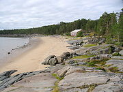
The White Sea contains a large number of islands, but most of them are small. The main island group is the Solovetsky Islands
, located almost in the middle of the sea, near the entrance to Onega Bay. Kiy Island
in Onega Bay is significant due to a historic monastery. Velikiy Island, located close to the shore, is the largest island in the Kandalaksha Gulf
.
. Its bottom is very uneven and contains the Kandalaksha Hollow in the northwest and the Solovetsky Islands in the south. Also, the Onega Bay has many small underwater elevations. The opening and the gorlo of the sea are rather shallow, with the depths about 50 metres or less. In addition, there is an underwater ridge in the northern part of the gorlo, resulting in maximum depths of 40 metres in that part. This hinders water exchange between the White and Barents seas. The exchange is however assisted by the tide
s, which are semidiurnal (rising twice a day), with the amplitude increasing from 1 metre on the south to 10 metres in Mezen Bay. Currents are rather weak in the open seas with the speed below 1 km/h, but they significantly strengthen in the bays. The tidal waves are much faster than the regular currents and reach the speeds of 9 km/h in Mezen Bay, 3.6 km/h in Onega Bay and 1.3 km/h in the Kandalaksha Gulf.
Rivers bring annually about 215 km3 of fresh water, on average, mostly to the Onega, Mezen and Dvina bays. The Northern Dvina River alone may contribute up to 171 km3 in some years, with the Mezen, Onega, Kem and Vyg rivers adding up to 38.5, 27.0, 12.5 and 11.5 km3, respectively. About 40% of this volume is brought during the snow melting in May, and the inflow is minimal in February–March. This inflow raises and lowers the sea level that promotes the water exchange with the Barents Sea. As a result, annually, about 2,000 km3 and 2,200 km3 flow in and out of the White Sea, respectively. The inflow of fresh water in spring decreases the surface salinity in the top 5–10 metre layer to 23‰ (parts per thousand) in the eastern and 26–27‰ in the western parts of the sea, reaching 10–12‰ in Dvina Bay; it also increases the content of silicon
and silicate
s in water, which is a characteristic feature of the White Sea.
Storms are the strongest in October–November. However, small sea depths reduce the wave height to the average of 1 metre, sometimes reaching 3–5 metres. The sea is quiet in July–August.
 The climate varies between polar
and moderate continental
with frequent fogs and clouds. Winds are predominantly southwestern in winter with speeds of 4–8 m/s. They bring cold air from the south, establishing the temperature of about –15 °C (February) over most of the sea. The northern part is warmer at about –9 °C, sometimes reaching –6 °C, due to the warm air masses from the Atlantic. Arctic anticyclones, however, change winds to the northeastern ones, bringing much colder weather with temperatures of about –25 °C. Summers are cold, cloudy and relatively humid, with northeastern winds and frequent rains. Average July temperatures are 8–10 °C. Occasional southeastern winds bring warm air from Europe, raising the temperature to 17–19 °C and sometimes even to 30 °C. Annual precipitations increase from 282 mm in the north 529 in the south.
In winter, from October–November till May–June, the sea freezes, with the average January water temperatures of –1.9 °C in the north, between –1.3 and –1.7 °С in the centre, and between –0.5 and –0.7 °С in the bays. These variations are due to the distribution of water salinity across the sea, which increases from 24–26‰ in the centre to 30.5‰ in the gorlo, reaching 34.0–34.5‰ toward the Barents Sea. The freezing period varies from year to year as shown in the satellite image to the right. The ice is not stationary, but 90% of it is floating and is continuously removed to the Barents Sea. Ice thickness is usually about 40 cm but may reach 150 cm in cold winters.
In summer, surface water warms up to 15 °С in the central part, but remains relatively cold in the north, at 7–8 °С, due to the water exchange between the surface and the cold bottom part which is enhanced by the shallow depths in the northern parts. Deep sea (about 100 m or more) is characterised by stable temperature (–1.4 °С) and salinity (30‰). The depth distribution of water temperature is very inhomogeneous across the sea. For example, at the exit from Dvina Bay, water temperature drops to 0 °C at the depth of only 12–15 m, but the same temperature is reached at 65 m at the exit from the Kandalaksha Gulf.
 The sea was known to the Novgorod people
since at least the 11th century and was rapidly explored because of its commercial significance for navigation and coastal forests rich in fur animals. One of the earliest settlements near the sea shores was established in the late 14th century in Kholmogory
, on the Northern Dvina River. From there, in 1492, a merchant fleet laden with grain and carrying ambassadors of Ivan III of Russia
sailed to Denmark, marking the establishment of the first international seaport in Russia.
The first foreign ship to arrive in Kholmogory was the English Edward Bonaventure commanded by Richard Chancellor
. Together with two other ships under the command of Hugh Willoughby, they were seeking a northern route to the Indies
, especially India and China. The expedition was sponsored by King Edward VI
and a group of about 240 English merchants and was authorised to establish trade connections. The ships of Willoughby were separated and the other two were lost at sea, but Edward Bonaventure managed to pass the White Sea and reach Kholmogory, from where Chancellor was escorted to Moscow to meet the Russian Tsar
, Ivan the Terrible. Returning from Russia in 1554, Chancellor brought a detailed description of Moscow and the Russian north, which were largely unknown to Europe, as well as a letter from the Tsar expressing desire to establish trade relations with England. In 1555, Queen Mary
issued a charter authorising the Muscovy Company
to trade with Russia via the White Sea route.
The British ships were soon followed by Dutch, and the port of Kholmogory became busy with shipments of fur and fish. Local and foreign shops and factories were established in the city at that time. The port was reinforced with a fortress which sustained a siege by the Polish-Lithuanian army in 1613. Increasing traffic was overloading the port, which was standing on shallow river waters and had a limited ship capacity. However, instead of expanding the old port, a new one, called New Kholmogory, was founded on the sea shores in 1584 and later became the city of Arkhangelsk.
Between the 15th and early 18th centuries, the White Sea provided the major trade route to Russia. This role decreased later with the foundation of Saint Petersburg
, which opened a more favorable connection via the Baltic Sea. From the 1920s, most Russian sea shipments were diverted from the White Sea to the new port of Murmansk
, where the waters did not freeze in winter.
s, about 60 species of fish, and 5 species of marine mammals. The fishing industry is relatively small, mostly targeting harp seal
, ringed seal
, herring
, saffron cod
, European smelt
, Atlantic cod
and Atlantic salmon
. There is a developing seaweed industry.
The White Sea is an important traffic centre of northwestern Russia, interconnecting various economic regions and providing an outlet to the foreign routes. The White Sea – Baltic Canal links it through Onega Lake to the Baltic Sea
and the major city and port of Saint Petersburg
. The Baltic Sea, in turn, is connected by the Volga–Baltic Waterway to the Volga River
, Black
, Caspian
, and Azov seas. The major ports on the White Sea are Arkhangelsk, Belomorsk
, Onega
, Mezen
, Kem, Kandalaksha
and Umba
. Despite being frozen in winter, the sea remains navigable all year around because of deployment of icebreaker
s.
Inlet
An inlet is a narrow body of water between islands or leading inland from a larger body of water, often leading to an enclosed body of water, such as a sound, bay, lagoon or marsh. In sea coasts an inlet usually refers to the actual connection between a bay and the ocean and is often called an...
of the Barents Sea
Barents Sea
The Barents Sea is a marginal sea of the Arctic Ocean, located north of Norway and Russia. Known in the Middle Ages as the Murman Sea, the sea takes its current name from the Dutch navigator Willem Barents...
located on the northwest coast of Russia
Russia
Russia or , officially known as both Russia and the Russian Federation , is a country in northern Eurasia. It is a federal semi-presidential republic, comprising 83 federal subjects...
. It is surrounded by Karelia
Karelia
Karelia , the land of the Karelian peoples, is an area in Northern Europe of historical significance for Finland, Russia, and Sweden...
to the west, the Kola Peninsula
Kola Peninsula
The Kola Peninsula is a peninsula in the far northwest of Russia. Constituting the bulk of the territory of Murmansk Oblast, it lies almost completely to the north of the Arctic Circle and is washed by the Barents Sea in the north and the White Sea in the east and southeast...
to the north, and the Kanin Peninsula
Kanin Peninsula
Kanin Peninsula is a large peninsula in Nenets Autonomous Okrug, Russia. Latitude : 68° Longitude : 45°It is surrounded by the White Sea to the west and by the Barents Sea to the north and east. Shoyna is one of the few communities on the peninsula....
to the northeast. The whole of the White Sea is under Russian sovereignty and considered to be part of the internal waters of Russia.
The major port of Arkhangelsk
Arkhangelsk
Arkhangelsk , formerly known as Archangel in English, is a city and the administrative center of Arkhangelsk Oblast, Russia. It lies on both banks of the Northern Dvina River near its exit into the White Sea in the north of European Russia. The city spreads for over along the banks of the river...
is located on the White Sea. For much of Russia's history this was Russia's main centre of international maritime trade, conducted by the so-called Pomors ("seaside settlers") from Kholmogory
Kholmogory
Kholmogory is a historic village and the administrative center of Kholmogorsky District of Arkhangelsk Oblast, Russia. It lies on the left bank of the Northern Dvina, along the Kholmogory Highway, 75 km southeast of Arkhangelsk and 90 km north of the Antonievo-Siysky Monastery. The name...
. In the modern era it became an important Soviet naval and submarine base. The White Sea-Baltic Canal
White Sea-Baltic Canal
The White Sea – Baltic Sea Canal , often abbreviated to White Sea Canal is a ship canal in Russia opened on 2 August 1933. It connects the White Sea with Lake Onega, which is further connected to the Baltic Sea. Until 1961, its original name was the Stalin White Sea – Baltic Sea Canal...
connects the White Sea with the Baltic Sea
Baltic Sea
The Baltic Sea is a brackish mediterranean sea located in Northern Europe, from 53°N to 66°N latitude and from 20°E to 26°E longitude. It is bounded by the Scandinavian Peninsula, the mainland of Europe, and the Danish islands. It drains into the Kattegat by way of the Øresund, the Great Belt and...
.
The White Sea is one of four seas named in English after common colour terms — the others being the Black Sea
Black Sea
The Black Sea is bounded by Europe, Anatolia and the Caucasus and is ultimately connected to the Atlantic Ocean via the Mediterranean and the Aegean seas and various straits. The Bosphorus strait connects it to the Sea of Marmara, and the strait of the Dardanelles connects that sea to the Aegean...
, the Red Sea
Red Sea
The Red Sea is a seawater inlet of the Indian Ocean, lying between Africa and Asia. The connection to the ocean is in the south through the Bab el Mandeb strait and the Gulf of Aden. In the north, there is the Sinai Peninsula, the Gulf of Aqaba, and the Gulf of Suez...
and the Yellow Sea
Yellow Sea
The Yellow Sea is the name given to the northern part of the East China Sea, which is a marginal sea of the Pacific Ocean. It is located between mainland China and the Korean Peninsula. Its name comes from the sand particles from Gobi Desert sand storms that turn the surface of the water golden...
.
Extent
The International Hydrographic OrganizationInternational Hydrographic Organization
The International Hydrographic Organization is the inter-governmental organisation representing the hydrographic community. It enjoys observer status at the UN and is the recognised competent authority on hydrographic surveying and nautical charting...
defines the northern limit of the White Sea as "A line joining Svyatoi Nos (Murmansk
Murmansk Oblast
Murmansk Oblast is a federal subject of Russia , located in the northwestern part of Russia. Its administrative center is the city of Murmansk.-Geography:...
Coast, 39°47'E) and Cape Kanin".
Topography
White Sea Throat
White Sea Throat is a 90 km-wide a strait, located at .It separates Kola Peninsula from Mezen Coast, and connects the White Sea in the south-west with the Barents Sea in the north-east.- References :* *...
called "gorlo" . Kandalaksha Gulf
Kandalaksha Gulf
The Kandalaksha Gulf is located in the Republic of Karelia, and Murmansk Oblast in northwestern Russia. Forming the north-western corner of the White Sea, it is one of four large bays and gulfs of this sea, the others being the Onega Bay , the Dvina Bay , and the Mezen Bay .The Kola Peninsula...
lies in the western part of the White Sea; it is the deepest part of the sea, reaching 340 metres (1,115 feet). On the south, Onega Bay
Onega Bay
The Onega Bay is located in [the Republic of Karelia and Arkhangelsk Oblast in Northwestern Russia, west of the city of Arkhangelsk. It is the southernmost of four large bays and gulfs of the White Sea, the others being the Dvina Bay, the Mezen Bay, and the Kandalaksha Gulf. The area of the bay is...
receives the Onega River
Onega River
The Onega is a river in Kargopolsky, Plesetsky, and Onezhsky Districts of Arkhangelsk Oblast in Russia. The Onega connects Lake Lacha with the Onega Bay in the White Sea southwest of Arkhangelsk, flowing in the northern direction. The discharge at the source is and at the mouth is . The river is ...
. To the southeast, the Dvina Bay
Dvina Bay
The Dvina Bay is located in Arkhangelsk Oblast in Northwestern Russia. It is one of four large bays and gulfs of the White Sea, the others being the Mezen Bay, the Onega Bay, and the Kandalaksha Gulf. The two main river emptying into the Dvina Bay is the Northern Dvina River, while the two cities...
receives the Northern Dvina River at the major port of Arkhangelsk
Arkhangelsk
Arkhangelsk , formerly known as Archangel in English, is a city and the administrative center of Arkhangelsk Oblast, Russia. It lies on both banks of the Northern Dvina River near its exit into the White Sea in the north of European Russia. The city spreads for over along the banks of the river...
. On the east side of the 'gorlo', opposite the Kola peninsula
Kola Peninsula
The Kola Peninsula is a peninsula in the far northwest of Russia. Constituting the bulk of the territory of Murmansk Oblast, it lies almost completely to the north of the Arctic Circle and is washed by the Barents Sea in the north and the White Sea in the east and southeast...
, is Mezen Bay
Mezen Bay
The Mezen Bay is located in Arkhangelsk Oblast and Nenets Autonomous Okrug in Northwestern Russia. It is one of four large bays and gulfs of the White Sea, the others being the Dvina Bay, the Onega Bay, and the Kandalaksha Gulf. The Mezen Bay is the easternmost of these, as it lies to the south of...
. It receives the Mezen River. Other major rivers flowing into the sea are the Vyg
Vyg River
The Vyg is a river in Republic of Karelia. Consists of the Upper Vyg, 135 km long, discharging into Lake Vygozero, and the Lower Vyg, 102 km long, flowing from Lake Vygozero and discharging into Onega Bay of the White Sea near Belomorsk. The Upper Vyg flows through several small lakes in...
, Niva
Niva River
Niva River is a river in the Murmansk Oblast in Russia. The length of the river is 36 km. The area of its basin is 12,800 km². The Niva River flows out of the Imandra Lake and into the Kandalaksha Gulf of the White Sea...
, Umba
Umba River (Russia)
Umba is a 123 km long river on the Kola Peninsula, Murmansk Oblast, Russia.-Geography:The river's source is Lake Umbozero, 100 km northeast of Kandalaksha, located between the mountains of the Khibiny Massif and the Lovozero Tundras on the Kola Peninsula. From there it flows south,...
, Varzuga
Varzuga River
Varzuga River is a river in the south of the Kola Peninsula in Murmansk Oblast, Russia. It is 254 km in length. The area of its basin is 9,840 km². The Varzuga River flows into the White Sea. It freezes up in October and stays under the ice until May.This is the most prolific atlantic...
and Ponoy
Ponoy River
Ponoy River is a river on the Kola Peninsula in Russia. It is 426 km in length. The area of its basin is 15,500 km².-Geography:...
.
The seabed of the central part and Dvina Bay is covered in silt
Silt
Silt is granular material of a size somewhere between sand and clay whose mineral origin is quartz and feldspar. Silt may occur as a soil or as suspended sediment in a surface water body...
and sand, whereas the bottom of the northern part, the Kandalaksha Gulf
Kandalaksha Gulf
The Kandalaksha Gulf is located in the Republic of Karelia, and Murmansk Oblast in northwestern Russia. Forming the north-western corner of the White Sea, it is one of four large bays and gulfs of this sea, the others being the Onega Bay , the Dvina Bay , and the Mezen Bay .The Kola Peninsula...
and Onega Bay is a mixture of sand and stones. Ice age deposits often emerge near the sea shores. Northwestern coasts are tall and rocky but the slope is much weaker at the southeastern side.
The White Sea contains a large number of islands, but most of them are small. The main island group is the Solovetsky Islands
Solovetsky Islands
The Solovetsky Islands , or Solovki , are an archipelago located in the Onega Bay of the White Sea, Russia. The islands are served by the Solovki Airport. Area: ....
, located almost in the middle of the sea, near the entrance to Onega Bay. Kiy Island
Kiy Island
Kiy-Island is an island in the Onega Bay of the White Sea, 8 km off-shore and 15 km from the town of Onega. The island stretches for 2 kilometres from north-west to south-east, but its width does not exceed 800 meters.The island includes wide and sandy beaches, piny woods rich with...
in Onega Bay is significant due to a historic monastery. Velikiy Island, located close to the shore, is the largest island in the Kandalaksha Gulf
Kandalaksha Gulf
The Kandalaksha Gulf is located in the Republic of Karelia, and Murmansk Oblast in northwestern Russia. Forming the north-western corner of the White Sea, it is one of four large bays and gulfs of this sea, the others being the Onega Bay , the Dvina Bay , and the Mezen Bay .The Kola Peninsula...
.
Hydrography and bathymetry
The White Sea is a water-filled depression in the block of a continental shelf known as the Baltic ShieldBaltic Shield
The Baltic Shield is located in Fennoscandia , northwest Russia and under the Baltic Sea. The Baltic Shield is defined as the exposed Precambrian northwest segment of the East European Craton...
. Its bottom is very uneven and contains the Kandalaksha Hollow in the northwest and the Solovetsky Islands in the south. Also, the Onega Bay has many small underwater elevations. The opening and the gorlo of the sea are rather shallow, with the depths about 50 metres or less. In addition, there is an underwater ridge in the northern part of the gorlo, resulting in maximum depths of 40 metres in that part. This hinders water exchange between the White and Barents seas. The exchange is however assisted by the tide
Tide
Tides are the rise and fall of sea levels caused by the combined effects of the gravitational forces exerted by the moon and the sun and the rotation of the Earth....
s, which are semidiurnal (rising twice a day), with the amplitude increasing from 1 metre on the south to 10 metres in Mezen Bay. Currents are rather weak in the open seas with the speed below 1 km/h, but they significantly strengthen in the bays. The tidal waves are much faster than the regular currents and reach the speeds of 9 km/h in Mezen Bay, 3.6 km/h in Onega Bay and 1.3 km/h in the Kandalaksha Gulf.
Rivers bring annually about 215 km3 of fresh water, on average, mostly to the Onega, Mezen and Dvina bays. The Northern Dvina River alone may contribute up to 171 km3 in some years, with the Mezen, Onega, Kem and Vyg rivers adding up to 38.5, 27.0, 12.5 and 11.5 km3, respectively. About 40% of this volume is brought during the snow melting in May, and the inflow is minimal in February–March. This inflow raises and lowers the sea level that promotes the water exchange with the Barents Sea. As a result, annually, about 2,000 km3 and 2,200 km3 flow in and out of the White Sea, respectively. The inflow of fresh water in spring decreases the surface salinity in the top 5–10 metre layer to 23‰ (parts per thousand) in the eastern and 26–27‰ in the western parts of the sea, reaching 10–12‰ in Dvina Bay; it also increases the content of silicon
Silicon
Silicon is a chemical element with the symbol Si and atomic number 14. A tetravalent metalloid, it is less reactive than its chemical analog carbon, the nonmetal directly above it in the periodic table, but more reactive than germanium, the metalloid directly below it in the table...
and silicate
Silicate
A silicate is a compound containing a silicon bearing anion. The great majority of silicates are oxides, but hexafluorosilicate and other anions are also included. This article focuses mainly on the Si-O anions. Silicates comprise the majority of the earth's crust, as well as the other...
s in water, which is a characteristic feature of the White Sea.
Storms are the strongest in October–November. However, small sea depths reduce the wave height to the average of 1 metre, sometimes reaching 3–5 metres. The sea is quiet in July–August.
Climate
Polar climate
Regions with a polar climate are characterized by a lack of warm summers . Regions with polar climate cover over 20% of the Earth. The sun shines 24 hours in the summer, and barely ever shines at all in the winter...
and moderate continental
Continental climate
Continental climate is a climate characterized by important annual variation in temperature due to the lack of significant bodies of water nearby...
with frequent fogs and clouds. Winds are predominantly southwestern in winter with speeds of 4–8 m/s. They bring cold air from the south, establishing the temperature of about –15 °C (February) over most of the sea. The northern part is warmer at about –9 °C, sometimes reaching –6 °C, due to the warm air masses from the Atlantic. Arctic anticyclones, however, change winds to the northeastern ones, bringing much colder weather with temperatures of about –25 °C. Summers are cold, cloudy and relatively humid, with northeastern winds and frequent rains. Average July temperatures are 8–10 °C. Occasional southeastern winds bring warm air from Europe, raising the temperature to 17–19 °C and sometimes even to 30 °C. Annual precipitations increase from 282 mm in the north 529 in the south.
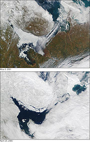
In winter, from October–November till May–June, the sea freezes, with the average January water temperatures of –1.9 °C in the north, between –1.3 and –1.7 °С in the centre, and between –0.5 and –0.7 °С in the bays. These variations are due to the distribution of water salinity across the sea, which increases from 24–26‰ in the centre to 30.5‰ in the gorlo, reaching 34.0–34.5‰ toward the Barents Sea. The freezing period varies from year to year as shown in the satellite image to the right. The ice is not stationary, but 90% of it is floating and is continuously removed to the Barents Sea. Ice thickness is usually about 40 cm but may reach 150 cm in cold winters.
In summer, surface water warms up to 15 °С in the central part, but remains relatively cold in the north, at 7–8 °С, due to the water exchange between the surface and the cold bottom part which is enhanced by the shallow depths in the northern parts. Deep sea (about 100 m or more) is characterised by stable temperature (–1.4 °С) and salinity (30‰). The depth distribution of water temperature is very inhomogeneous across the sea. For example, at the exit from Dvina Bay, water temperature drops to 0 °C at the depth of only 12–15 m, but the same temperature is reached at 65 m at the exit from the Kandalaksha Gulf.
History
Veliky Novgorod
Veliky Novgorod is one of Russia's most historic cities and the administrative center of Novgorod Oblast. It is situated on the M10 federal highway connecting Moscow and St. Petersburg. The city lies along the Volkhov River just below its outflow from Lake Ilmen...
since at least the 11th century and was rapidly explored because of its commercial significance for navigation and coastal forests rich in fur animals. One of the earliest settlements near the sea shores was established in the late 14th century in Kholmogory
Kholmogory
Kholmogory is a historic village and the administrative center of Kholmogorsky District of Arkhangelsk Oblast, Russia. It lies on the left bank of the Northern Dvina, along the Kholmogory Highway, 75 km southeast of Arkhangelsk and 90 km north of the Antonievo-Siysky Monastery. The name...
, on the Northern Dvina River. From there, in 1492, a merchant fleet laden with grain and carrying ambassadors of Ivan III of Russia
Ivan III of Russia
Ivan III Vasilyevich , also known as Ivan the Great, was a Grand Prince of Moscow and "Grand Prince of all Rus"...
sailed to Denmark, marking the establishment of the first international seaport in Russia.
The first foreign ship to arrive in Kholmogory was the English Edward Bonaventure commanded by Richard Chancellor
Richard Chancellor
Richard Chancellor was an English explorer and navigator; the first to penetrate to the White Sea and establish relations with Russia....
. Together with two other ships under the command of Hugh Willoughby, they were seeking a northern route to the Indies
Indies
The Indies is a term that has been used to describe the lands of South and Southeast Asia, occupying all of the present India, Pakistan, Bangladesh, Myanmar, Nepal, Sri Lanka, the Maldives, and also Thailand, Cambodia, Laos, Vietnam, Brunei, Singapore, the Philippines, East Timor, Malaysia and...
, especially India and China. The expedition was sponsored by King Edward VI
Edward VI of England
Edward VI was the King of England and Ireland from 28 January 1547 until his death. He was crowned on 20 February at the age of nine. The son of Henry VIII and Jane Seymour, Edward was the third monarch of the Tudor dynasty and England's first monarch who was raised as a Protestant...
and a group of about 240 English merchants and was authorised to establish trade connections. The ships of Willoughby were separated and the other two were lost at sea, but Edward Bonaventure managed to pass the White Sea and reach Kholmogory, from where Chancellor was escorted to Moscow to meet the Russian Tsar
Tsar
Tsar is a title used to designate certain European Slavic monarchs or supreme rulers. As a system of government in the Tsardom of Russia and Russian Empire, it is known as Tsarist autocracy, or Tsarism...
, Ivan the Terrible. Returning from Russia in 1554, Chancellor brought a detailed description of Moscow and the Russian north, which were largely unknown to Europe, as well as a letter from the Tsar expressing desire to establish trade relations with England. In 1555, Queen Mary
Mary I of England
Mary I was queen regnant of England and Ireland from July 1553 until her death.She was the only surviving child born of the ill-fated marriage of Henry VIII and his first wife Catherine of Aragon. Her younger half-brother, Edward VI, succeeded Henry in 1547...
issued a charter authorising the Muscovy Company
Muscovy Company
The Muscovy Company , was a trading company chartered in 1555. It was the first major chartered joint stock company, the precursor of the type of business that would soon flourish in England, and became closely associated with such famous names as Henry Hudson and William Baffin...
to trade with Russia via the White Sea route.
The British ships were soon followed by Dutch, and the port of Kholmogory became busy with shipments of fur and fish. Local and foreign shops and factories were established in the city at that time. The port was reinforced with a fortress which sustained a siege by the Polish-Lithuanian army in 1613. Increasing traffic was overloading the port, which was standing on shallow river waters and had a limited ship capacity. However, instead of expanding the old port, a new one, called New Kholmogory, was founded on the sea shores in 1584 and later became the city of Arkhangelsk.
Between the 15th and early 18th centuries, the White Sea provided the major trade route to Russia. This role decreased later with the foundation of Saint Petersburg
Saint Petersburg
Saint Petersburg is a city and a federal subject of Russia located on the Neva River at the head of the Gulf of Finland on the Baltic Sea...
, which opened a more favorable connection via the Baltic Sea. From the 1920s, most Russian sea shipments were diverted from the White Sea to the new port of Murmansk
Murmansk
Murmansk is a city and the administrative center of Murmansk Oblast, Russia. It serves as a seaport and is located in the extreme northwest part of Russia, on the Kola Bay, from the Barents Sea on the northern shore of the Kola Peninsula, not far from Russia's borders with Norway and Finland...
, where the waters did not freeze in winter.
Fauna and economy
The sea hosts more than 700 species of invertebrateInvertebrate
An invertebrate is an animal without a backbone. The group includes 97% of all animal species – all animals except those in the chordate subphylum Vertebrata .Invertebrates form a paraphyletic group...
s, about 60 species of fish, and 5 species of marine mammals. The fishing industry is relatively small, mostly targeting harp seal
Harp Seal
The harp seal or saddleback seal is a species of earless seal native to the northernmost Atlantic Ocean and adjacent parts of the Arctic Ocean. It now belongs to the monotypic genus Pagophilus. Its scientific name, Pagophilus groenlandicus, means "ice-lover from Greenland", and its synonym, Phoca...
, ringed seal
Ringed Seal
The ringed seal , also known as the jar seal and as netsik or nattiq by the Inuit, is an earless seal inhabiting the Arctic and sub-Arctic regions...
, herring
Herring
Herring is an oily fish of the genus Clupea, found in the shallow, temperate waters of the North Pacific and the North Atlantic oceans, including the Baltic Sea. Three species of Clupea are recognized. The main taxa, the Atlantic herring and the Pacific herring may each be divided into subspecies...
, saffron cod
Saffron cod
The saffron cod , is a commercially harvested fish closely related to true cods . It is dark grey-green to brown, with spots on its sides and pale towards the belly. It may grow to 60 cm and weigh up to 1.3 kg....
, European smelt
European smelt
The Smelt or European smelt is a species of fish in the Osmeridae family.- Shape and appearance :The body of the European smelt is typically 15 to 18 cm long, slender and slightly flattened on either side. Larger fish may reach 30 cm in length. Smelts have a slightly translucent body...
, Atlantic cod
Atlantic cod
The Atlantic cod, Gadus morhua, is a well-known demersal food fish belonging to the family Gadidae. It is also commercially known as cod, codling or haberdine....
and Atlantic salmon
Atlantic salmon
The Atlantic salmon is a species of fish in the family Salmonidae, which is found in the northern Atlantic Ocean and in rivers that flow into the north Atlantic and the north Pacific....
. There is a developing seaweed industry.
The White Sea is an important traffic centre of northwestern Russia, interconnecting various economic regions and providing an outlet to the foreign routes. The White Sea – Baltic Canal links it through Onega Lake to the Baltic Sea
Baltic Sea
The Baltic Sea is a brackish mediterranean sea located in Northern Europe, from 53°N to 66°N latitude and from 20°E to 26°E longitude. It is bounded by the Scandinavian Peninsula, the mainland of Europe, and the Danish islands. It drains into the Kattegat by way of the Øresund, the Great Belt and...
and the major city and port of Saint Petersburg
Saint Petersburg
Saint Petersburg is a city and a federal subject of Russia located on the Neva River at the head of the Gulf of Finland on the Baltic Sea...
. The Baltic Sea, in turn, is connected by the Volga–Baltic Waterway to the Volga River
Volga River
The Volga is the largest river in Europe in terms of length, discharge, and watershed. It flows through central Russia, and is widely viewed as the national river of Russia. Out of the twenty largest cities of Russia, eleven, including the capital Moscow, are situated in the Volga's drainage...
, Black
Black Sea
The Black Sea is bounded by Europe, Anatolia and the Caucasus and is ultimately connected to the Atlantic Ocean via the Mediterranean and the Aegean seas and various straits. The Bosphorus strait connects it to the Sea of Marmara, and the strait of the Dardanelles connects that sea to the Aegean...
, Caspian
Caspian Sea
The Caspian Sea is the largest enclosed body of water on Earth by area, variously classed as the world's largest lake or a full-fledged sea. The sea has a surface area of and a volume of...
, and Azov seas. The major ports on the White Sea are Arkhangelsk, Belomorsk
Belomorsk
Belomorsk is a town and the administrative center of Belomorsky District of the Republic of Karelia, Russia, located on the Onega Bay on the shore of the White Sea. Population:...
, Onega
Onega (town)
-External links:...
, Mezen
Mezen
-See also:*Administrative divisions of Arkhangelsk Oblast...
, Kem, Kandalaksha
Kandalaksha
Kandalaksha is a town in Kandalakshsky District of Murmansk Oblast, Russia, located at the head of Kandalaksha Gulf on the White Sea, beyond the Arctic Circle. Population: 40,564 ; -History:The settlement has existed since the 11th century...
and Umba
Umba, Russia
Umba is an urban locality in Tersky District of Murmansk Oblast, Russia, located on the Kola Peninsula at the point where the Umba River flows into the Kandalaksha Gulf. Population:...
. Despite being frozen in winter, the sea remains navigable all year around because of deployment of icebreaker
Icebreaker
An icebreaker is a special-purpose ship or boat designed to move and navigate through ice-covered waters. Although the term usually refers to ice-breaking ships, it may also refer to smaller vessels .For a ship to be considered an icebreaker, it requires three traits most...
s.