
Old World
Encyclopedia
The Old World consists of those parts of the world
known to classical antiquity
and the European Middle Ages
. It is used in the context of, and contrast with, the "New World
" (i.e., the Americas
).
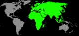
The Old World comprises Africa
, Asia
, and Europe
(collectively known as Afro-Eurasia
), plus surrounding islands (or at least those parts which were known to classical geography before the 15th century).
The concept of the three continents in the Old World goes back to classical antiquity. Their boundaries as defined by Ptolemy
and other geographers of antiquity were drawn along the Nile
and Don
rivers. This definition remained influential throughout the Middle Ages (see T and O map
) and the Early Modern period
.
World map
A world map is a map of the surface of the Earth, which may be made using any of a number of different map projections. A map projection is any method of representing the surface of a sphere or other three-dimensional body on a plane....
known to classical antiquity
Classical antiquity
Classical antiquity is a broad term for a long period of cultural history centered on the Mediterranean Sea, comprising the interlocking civilizations of ancient Greece and ancient Rome, collectively known as the Greco-Roman world...
and the European Middle Ages
Middle Ages
The Middle Ages is a periodization of European history from the 5th century to the 15th century. The Middle Ages follows the fall of the Western Roman Empire in 476 and precedes the Early Modern Era. It is the middle period of a three-period division of Western history: Classic, Medieval and Modern...
. It is used in the context of, and contrast with, the "New World
New World
The New World is one of the names used for the Western Hemisphere, specifically America and sometimes Oceania . The term originated in the late 15th century, when America had been recently discovered by European explorers, expanding the geographical horizon of the people of the European middle...
" (i.e., the Americas
Americas
The Americas, or America , are lands in the Western hemisphere, also known as the New World. In English, the plural form the Americas is often used to refer to the landmasses of North America and South America with their associated islands and regions, while the singular form America is primarily...
).
The Old World comprises Africa
Africa
Africa is the world's second largest and second most populous continent, after Asia. At about 30.2 million km² including adjacent islands, it covers 6% of the Earth's total surface area and 20.4% of the total land area...
, Asia
Asia
Asia is the world's largest and most populous continent, located primarily in the eastern and northern hemispheres. It covers 8.7% of the Earth's total surface area and with approximately 3.879 billion people, it hosts 60% of the world's current human population...
, and Europe
Europe
Europe is, by convention, one of the world's seven continents. Comprising the westernmost peninsula of Eurasia, Europe is generally 'divided' from Asia to its east by the watershed divides of the Ural and Caucasus Mountains, the Ural River, the Caspian and Black Seas, and the waterways connecting...
(collectively known as Afro-Eurasia
Afro-Eurasia
Afro-Eurasia or less commonly Afrasia or Eurafrasia is the term used to describe the largest landmass on earth. It may be defined as a supercontinent, consisting of Africa and Eurasia...
), plus surrounding islands (or at least those parts which were known to classical geography before the 15th century).
The concept of the three continents in the Old World goes back to classical antiquity. Their boundaries as defined by Ptolemy
Ptolemy
Claudius Ptolemy , was a Roman citizen of Egypt who wrote in Greek. He was a mathematician, astronomer, geographer, astrologer, and poet of a single epigram in the Greek Anthology. He lived in Egypt under Roman rule, and is believed to have been born in the town of Ptolemais Hermiou in the...
and other geographers of antiquity were drawn along the Nile
Nile
The Nile is a major north-flowing river in North Africa, generally regarded as the longest river in the world. It is long. It runs through the ten countries of Sudan, South Sudan, Burundi, Rwanda, Democratic Republic of the Congo, Tanzania, Kenya, Ethiopia, Uganda and Egypt.The Nile has two major...
and Don
Don River (Russia)
The Don River is one of the major rivers of Russia. It rises in the town of Novomoskovsk 60 kilometres southeast from Tula, southeast of Moscow, and flows for a distance of about 1,950 kilometres to the Sea of Azov....
rivers. This definition remained influential throughout the Middle Ages (see T and O map
T and O map
A T and O map or O-T or T-O map , is a type of medieval world map, sometimes also called a Beatine map or a Beatus map because one of the earliest known representations of this sort is attributed to Beatus of Liébana, an 8th-century Spanish monk...
) and the Early Modern period
Early modern period
In history, the early modern period of modern history follows the late Middle Ages. Although the chronological limits of the period are open to debate, the timeframe spans the period after the late portion of the Middle Ages through the beginning of the Age of Revolutions...
.
See also
- Afro-EurasiaAfro-EurasiaAfro-Eurasia or less commonly Afrasia or Eurafrasia is the term used to describe the largest landmass on earth. It may be defined as a supercontinent, consisting of Africa and Eurasia...
- Age of Exploration
- Eastern HemisphereEastern HemisphereThe Eastern Hemisphere, also Eastern hemisphere or eastern hemisphere, is a geographical term for the half of the Earth that is east of the Prime Meridian and west of 180° longitude. It is also used to refer to Europe, Asia, Africa, and Australasia, vis-à-vis the Western Hemisphere, which includes...
- Far EastFar EastThe Far East is an English term mostly describing East Asia and Southeast Asia, with South Asia sometimes also included for economic and cultural reasons.The term came into use in European geopolitical discourse in the 19th century,...
- New World New WorldThe New World is one of the names used for the Western Hemisphere, specifically America and sometimes Oceania . The term originated in the late 15th century, when America had been recently discovered by European explorers, expanding the geographical horizon of the people of the European middle...
- Synoptic table of the principal old world prehistoric culturesSynoptic table of the principal old world prehistoric culturesThe synoptic table of the principal old world prehistoric cultures gives a rough picture of the relationships between the various principal cultures of prehistory outside the Americas, Antarctica, Australia and Oceania...