

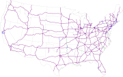
Interstate Highway System
Encyclopedia
Limited-access road
A limited-access road known by various terms worldwide, including limited-access highway, dual-carriageway and expressway, is a highway or arterial road for high-speed traffic which has many or most characteristics of a controlled-access highway , including limited or no access to adjacent...
s including freeways, highway
Highway
A highway is any public road. In American English, the term is common and almost always designates major roads. In British English, the term designates any road open to the public. Any interconnected set of highways can be variously referred to as a "highway system", a "highway network", or a...
s, and expressways forming part of the National Highway System
National Highway System (United States)
The National Highway System is a network of strategic highways within the United States, including the Interstate Highway System and other roads serving major airports, ports, rail or truck terminals, railway stations, pipeline terminals and other strategic transport facilities.Individual states...
of the United States of America. The system, which is named for President Dwight D. Eisenhower
Dwight D. Eisenhower
Dwight David "Ike" Eisenhower was the 34th President of the United States, from 1953 until 1961. He was a five-star general in the United States Army...
, who championed its formation, serves nearly all major U.S. cities. Construction was authorized by the Federal-Aid Highway Act of 1956 and took 35 years. The network has since been extended and as of 2006 it had a total length of 46876 miles (75,439.4 km). About one-third of all miles driven in the country use the Interstate system (2003 figures). The cost of construction has been estimated at $425 billion (in 2006 dollars), making it the largest public works project in history.
Planning
The Interstate Highway System had been lobbied for by major U.S. automobileAutomobile
An automobile, autocar, motor car or car is a wheeled motor vehicle used for transporting passengers, which also carries its own engine or motor...
manufacturers and championed by President Dwight D. Eisenhower
Dwight D. Eisenhower
Dwight David "Ike" Eisenhower was the 34th President of the United States, from 1953 until 1961. He was a five-star general in the United States Army...
, who was influenced by his experiences as a young Army officer crossing the country in the 1919 Army Convoy
Transcontinental Motor Convoy
The Transcontinental Motor Convoys were early 20th century vehicle convoys, including three US Army truck trains, that crossed the United States to the west coast...
on the Lincoln Highway
Lincoln Highway
The Lincoln Highway was the first road across the United States of America.Conceived and promoted by entrepreneur Carl G. Fisher, the Lincoln Highway spanned coast-to-coast from Times Square in New York City to Lincoln Park in San Francisco, originally through 13 states: New York, New Jersey,...
, the first road across America.
Initial federal planning for a nationwide highway system began in 1921 when the Bureau of Public Roads
Federal Highway Administration
The Federal Highway Administration is a division of the United States Department of Transportation that specializes in highway transportation. The agency's major activities are grouped into two "programs," the Federal-aid Highway Program and the Federal Lands Highway Program...
asked the Army
United States Army
The United States Army is the main branch of the United States Armed Forces responsible for land-based military operations. It is the largest and oldest established branch of the U.S. military, and is one of seven U.S. uniformed services...
to provide a list of roads it considered necessary for national defense. This resulted in the Pershing Map
Pershing Map
The Pershing Map was the first blueprint for a national highway system in the United States, with many of the proposed roads later forming a substantial portion of the Interstate Highway System....
. Later that decade, highways such as the New York parkway system were built as part of local or state highway systems.
As automobile traffic increased, planners saw a need for such an interconnected national system to supplement the existing, largely non-freeway, United States Numbered Highway system. By the late 1930s, planning had expanded to a system of new superhighways.
In 1938, President Franklin D. Roosevelt
Franklin D. Roosevelt
Franklin Delano Roosevelt , also known by his initials, FDR, was the 32nd President of the United States and a central figure in world events during the mid-20th century, leading the United States during a time of worldwide economic crisis and world war...
gave Thomas MacDonald
Thomas Harris MacDonald
Thomas Harris "Chief" MacDonald was an American civil engineer and politician with tremendous influence in building the country's interstate highway system...
, chief at the Bureau of Public Roads, a hand-drawn map of the U.S. marked with eight superhighway corridors for study. In 1939, Bureau of Public Roads Division of Information chief Herbert S. Fairbank wrote a report entitled Toll Roads and Free Roads, "the first formal description of what became the interstate highway system," and in 1944 the similarly themed Interregional Highways.
Eisenhower gained an appreciation of the German Autobahn network as a necessary component of a national defense system while he was serving as Supreme Commander of the Allied forces
Allies of World War II
The Allies of World War II were the countries that opposed the Axis powers during the Second World War . Former Axis states contributing to the Allied victory are not considered Allied states...
in Europe during World War II
European Theatre of World War II
The European Theatre of World War II was a huge area of heavy fighting across Europe from Germany's invasion of Poland on September 1, 1939 until the end of the war with the German unconditional surrender on May 8, 1945...
. He recognized that the proposed system would also provide key ground transport routes for military supplies and troop deployments in case of an emergency or foreign invasion.

Charles Erwin Wilson
Charles Erwin Wilson , American businessman and politician, was United States Secretary of Defense from 1953 to 1957 under President Eisenhower. Known as "Engine Charlie", he previously worked as CEO for General Motors. In the wake of the Korean War, he cut the defense budget significantly.-Early...
, who was still head of General Motors when President Eisenhower selected him as Secretary of Defense in January 1953.
Construction
The Interstate Highway System was authorized by the Federal Aid Highway Act of 1956Federal Aid Highway Act of 1956
The Federal-Aid Highway Act of 1956, popularly known as the National Interstate and Defense Highways Act , was enacted on June 29, 1956, when Dwight D. Eisenhower signed the bill into law...
– popularly known as the National Interstate and Defense Highways Act of 1956 – on June 29.
Three states have claimed the title of first Interstate Highway. Missouri claims that the first three contracts under the new program were signed in Missouri on August 2, 1956. The first contract signed was for U.S. 66. On August 13, 1956, Missouri awarded the first contract based on new Interstate Highway funding.
Kansas claims that it was the first to start paving after the act was signed. Preliminary construction had taken place before the act was signed, and paving started September 26, 1956. The state marked its portion of I-70 as the first project in the United States completed under the provisions of the new Federal-Aid Highway Act of 1956.
According to information liaison specialist, Richard Weingroff, the Pennsylvania Turnpike
Pennsylvania Turnpike
The Pennsylvania Turnpike is a toll highway system operated by the Pennsylvania Turnpike Commission in the Commonwealth of Pennsylvania, United States. The three sections of the turnpike system total . The main section extends from Ohio to New Jersey and is long...
could also be considered one of the first Interstate Highways. On October 1, 1940, 162 miles (261 km) of the highway now designated I-70 and I-76 opened between Irwin
Irwin, Pennsylvania
Irwin is a borough in Westmoreland County, Pennsylvania, southeast of Pittsburgh. Some of the most extensive bituminous coal deposits in the State are located here. In the past, iron foundries, flour mills, car shops, facing and planing mills, electrical goods, and mirror factories provided...
and Carlisle
Carlisle, Pennsylvania
Carlisle is a borough in and the county seat of Cumberland County, Pennsylvania, United States. The name is traditionally pronounced with emphasis on the second syllable. Carlisle is located within the Cumberland Valley, a highly productive agricultural region. As of the 2010 census, the borough...
. The Commonwealth of Pennsylvania refers to the turnpike as the Granddaddy of the Pikes.
Nebraska was the first state to complete its mainline Interstate Highway, finishing its section of Interstate 80
Interstate 80 in Nebraska
In the U.S. state of Nebraska, Interstate 80 runs west from Omaha to the Wyoming state border, ultimately terminating in San Francisco, California. When it completed construction of the stretch of Interstate 80 spanning the state on October 19, 1974, Nebraska was the first state in the nation to...
on October 19, 1974. The opening of I-70
Interstate 70 in Colorado
Interstate 70 is a transcontinental Interstate Highway in the United States, stretching from Cove Fort, Utah to Baltimore, Maryland. In Colorado, the highway traverses an east–west route across the center of the state. In western Colorado, the highway connects the metropolitan areas of Grand...
through Glenwood Canyon
Glenwood Canyon
Glenwood Canyon is a rugged scenic canyon on the Colorado River in western Colorado in the United States. Its canyon walls climb as high as above the Colorado River. It is the largest such canyon on the Upper Colorado...
in 1992 is often cited as the completion of the originally planned system. The initial cost estimate for the system was $25 billion over 12 years; it ended up costing $114 billion (adjusted for inflation, $425 billion in 2006 dollars) and took 35 years.
1992–present
Additional spurs and loops/bypasses remain under construction, such as Interstate 485Interstate 485
Interstate 485 is an Interstate Highway and a nearly completed beltway around Charlotte, North Carolina.-Route description:The western, southern and eastern segments of the beltway are complete and open to traffic...
in North Carolina
North Carolina
North Carolina is a state located in the southeastern United States. The state borders South Carolina and Georgia to the south, Tennessee to the west and Virginia to the north. North Carolina contains 100 counties. Its capital is Raleigh, and its largest city is Charlotte...
, which has been under construction since the 1980s. A few main routes not part of the original plan remain under construction, such as Interstate 22
Interstate 22
Interstate 22 , when it is completed, will follow the U.S. Highway 78 corridor along a 213-mile-long route from Memphis, Tennessee, to Birmingham, Alabama, as an Interstate Highway. Interstate 22 will connect Interstate 240 and Interstate 40 in the northwest with Interstate 65 and Interstate...
in Tennessee
Tennessee
Tennessee is a U.S. state located in the Southeastern United States. It has a population of 6,346,105, making it the nation's 17th-largest state by population, and covers , making it the 36th-largest by total land area...
, Mississippi
Mississippi
Mississippi is a U.S. state located in the Southern United States. Jackson is the state capital and largest city. The name of the state derives from the Mississippi River, which flows along its western boundary, whose name comes from the Ojibwe word misi-ziibi...
, and Alabama
Alabama
Alabama is a state located in the southeastern region of the United States. It is bordered by Tennessee to the north, Georgia to the east, Florida and the Gulf of Mexico to the south, and Mississippi to the west. Alabama ranks 30th in total land area and ranks second in the size of its inland...
and the extension of Interstate 69
Interstate 69
Interstate 69 is an Interstate Highway in the United States. It exists in two parts: a completed highway from Indianapolis, Indiana, northeast to the Canadian border in Port Huron, Michigan, and a mostly proposed extension southwest to the Mexican border in Texas...
from Indiana
Indiana
Indiana is a US state, admitted to the United States as the 19th on December 11, 1816. It is located in the Midwestern United States and Great Lakes Region. With 6,483,802 residents, the state is ranked 15th in population and 16th in population density. Indiana is ranked 38th in land area and is...
to Texas
Texas
Texas is the second largest U.S. state by both area and population, and the largest state by area in the contiguous United States.The name, based on the Caddo word "Tejas" meaning "friends" or "allies", was applied by the Spanish to the Caddo themselves and to the region of their settlement in...
. Officials have also identified some non-Interstate corridors for future inclusion into the system, either by construction of new Interstate routes or upgrade of existing roads to Interstate standards.
Due to the cancellation of the Somerset Freeway, Interstate 95
Interstate 95 in New Jersey
Interstate 95 is a major Interstate Highway that traverses the full extent of the East Coast of the United States, from Florida to Maine...
is discontinuous in New Jersey
New Jersey
New Jersey is a state in the Northeastern and Middle Atlantic regions of the United States. , its population was 8,791,894. It is bordered on the north and east by the state of New York, on the southeast and south by the Atlantic Ocean, on the west by Pennsylvania and on the southwest by Delaware...
. Authorized by the federal government in 2004, the Pennsylvania Turnpike/Interstate 95 Interchange Project
Pennsylvania Turnpike/Interstate 95 Interchange Project
The Pennsylvania Turnpike/Interstate 95 Interchange Project is a project to build an interchange where Interstate 95 crosses the Pennsylvania Turnpike in Bristol Township, Pennsylvania. This will fill the gap that exists on I-95 through New Jersey due to the cancellation of the Somerset Freeway....
is scheduled to connect the separate sections of I-95 to form a continuous route, completing the final section of the original plan. Construction began in 2010.
Standards
The American Association of State Highway and Transportation OfficialsAmerican Association of State Highway and Transportation Officials
AASHTO, the American Association of State Highway and Transportation Officials, is a standards setting body which publishes specifications, test protocols and guidelines which are used in highway design and construction throughout the United States...
(AASHTO) has defined a set of standards that all new Interstates must meet unless a waiver from the Federal Highway Administration
Federal Highway Administration
The Federal Highway Administration is a division of the United States Department of Transportation that specializes in highway transportation. The agency's major activities are grouped into two "programs," the Federal-aid Highway Program and the Federal Lands Highway Program...
(FHWA) is obtained. One almost absolute standard is the controlled access nature of the roads. With few exceptions, traffic light
Traffic light
Traffic lights, which may also be known as stoplights, traffic lamps, traffic signals, signal lights, robots or semaphore, are signalling devices positioned at road intersections, pedestrian crossings and other locations to control competing flows of traffic...
s (and cross traffic in general) are limited to toll booth
Toll house
A tollhouse or toll house is a building with accommodation for a toll collector, beside a tollgate on a toll road or canal. Many tollhouses were built by turnpike trusts in England, Wales and Scotland during the 18th and early 19th centuries...
s and ramp meter
Ramp meter
A ramp meter, ramp signal or metering light is a device, usually a basic traffic light or a two-section signal light together with a signal controller, that regulates the flow of traffic entering freeways according to current traffic conditions...
s (metered flow control for lane merging during rush hour
Rush hour
A rush hour or peak hour is a part of the day during which traffic congestion on roads and crowding on public transport is at its highest. Normally, this happens twice a day—once in the morning and once in the evening, the times during when the most people commute...
).
Speed limits
Being freeways, Interstate Highways usually have the highest speed limitSpeed limit
Road speed limits are used in most countries to regulate the speed of road vehicles. Speed limits may define maximum , minimum or no speed limit and are normally indicated using a traffic sign...
s in a given area. Speed limits are determined by individual states. From 1974 to 1987, the maximum speed limit on any highway in the United States was 55 mi/h, in accordance with federal law. Currently, rural speed limits generally range from 65 to 75 mph (104.6 to 120.7 km/h), although several portions of I-10
Interstate 10
Interstate 10 is the fourth-longest Interstate Highway in the United States, after I-90, I-80, and I-40. It is the southernmost east–west, coast-to-coast Interstate Highway, although I-4 and I-8 are further south. It stretches from the Pacific Ocean at State Route 1 in Santa Monica,...
and I-20
Interstate 20
Interstate 20 is a major east–west Interstate Highway in the Southern United States. I‑20 runs 1,535 miles from near Kent, Texas, at Interstate 10 to Florence, South Carolina, at Interstate 95...
in rural western Texas, along with a portion of I-15
Interstate 15
Interstate 15 is the fourth-longest north–south Interstate Highway in the United States, traveling through the states of California, Nevada, Arizona, Utah, Idaho, and Montana from San Diego to the Canadian border...
in rural central Utah, have speed limits of 80 mph (128.7 km/h). Typically, lower limits are established in the more densely populated Northeastern
Northeastern United States
The Northeastern United States is a region of the United States as defined by the United States Census Bureau.-Composition:The region comprises nine states: the New England states of Connecticut, Maine, Massachusetts, New Hampshire, Rhode Island and Vermont; and the Mid-Atlantic states of New...
states, while higher speed limits are established in the less densely populated Southern
Southern United States
The Southern United States—commonly referred to as the American South, Dixie, or simply the South—constitutes a large distinctive area in the southeastern and south-central United States...
and Western
Western United States
.The Western United States, commonly referred to as the American West or simply "the West," traditionally refers to the region comprising the westernmost states of the United States. Because the U.S. expanded westward after its founding, the meaning of the West has evolved over time...
states.
For example, the maximum speed limit is 65 mph (104.6 km/h) in New England, New York, and New Jersey, and 50 mph (80.5 km/h) in the District of Columbia.
Other uses
As one of the components of the National Highway System, Interstate Highways improve the mobility of military troops to and from airports, seaports, rail terminals, and other military bases. Interstate Highways also connect to other roads that are a part of the Strategic Highway Network, a system of roads identified as critical to the U.S. Department of Defense.The system has also been used to facilitate evacuations in the face of hurricanes and other natural disasters. An option for maximizing traffic throughput on a highway is to reverse the flow of traffic on one side of a divider so that all lanes become outbound lanes. This procedure, known as contraflow lane reversal
Contraflow lane reversal
Contraflow lane reversal refers to plans that alter the normal flow of traffic, typically on a controlled-access highway , to either aid in an emergency evacuation or, as part of routine maintenance activities, to facilitate widening or reconstruction of one of the highway's carriageways...
, has been employed several times for hurricane evacuations. After public outcry regarding the inefficiency of evacuating from southern Louisiana prior to Hurricane Georges
Hurricane Georges
Hurricane Georges was a very destructive, powerful and long-lived Cape Verde-type Category 4 hurricane. Georges was the seventh tropical storm, fourth hurricane, and second major hurricane of the 1998 Atlantic hurricane season...
' landfall in September 1998, government officials looked towards contraflow to improve evacuation times. In Savannah, Georgia
Savannah, Georgia
Savannah is the largest city and the county seat of Chatham County, in the U.S. state of Georgia. Established in 1733, the city of Savannah was the colonial capital of the Province of Georgia and later the first state capital of Georgia. Today Savannah is an industrial center and an important...
, and Charleston, South Carolina
Charleston, South Carolina
Charleston is the second largest city in the U.S. state of South Carolina. It was made the county seat of Charleston County in 1901 when Charleston County was founded. The city's original name was Charles Towne in 1670, and it moved to its present location from a location on the west bank of the...
, in 1999, lanes of Interstates 16
Interstate 16
Interstate 16 , also known as Jim Gillis Historic Savannah Parkway or State Route 404 , is an intrastate Interstate Highway located entirely within the state of Georgia, United States...
and 26
Interstate 26
Interstate 26 is a nominally east–west main route of the Interstate Highway System in the Southeastern United States. I-26 runs from the junction of U.S. Route 11W and U.S. Route 23 in Kingsport, Tennessee, generally southeastward to U.S. Route 17 in Charleston, South Carolina...
were used in a contraflow configuration in anticipation of Hurricane Floyd
Hurricane Floyd
Hurricane Floyd was the sixth named storm, fourth hurricane, and third major hurricane in the 1999 Atlantic hurricane season. Floyd triggered the third largest evacuation in US history when 2.6 million coastal residents of five states were ordered from their homes as it approached...
with mixed results.
In 2004, contraflow was employed ahead of Hurricane Charley
Hurricane Charley
Hurricane Charley was the third named storm, the second hurricane, and the second major hurricane of the 2004 Atlantic hurricane season. Charley lasted from August 9 to August 15, and at its peak intensity it attained 150 mph winds, making it a strong Category 4 hurricane on the...
in the Tampa, Florida
Tampa, Florida
Tampa is a city in the U.S. state of Florida. It serves as the county seat for Hillsborough County. Tampa is located on the west coast of Florida. The population of Tampa in 2010 was 335,709....
area and on the Gulf Coast
Gulf Coast of the United States
The Gulf Coast of the United States, sometimes referred to as the Gulf South, South Coast, or 3rd Coast, comprises the coasts of American states that are on the Gulf of Mexico, which includes Texas, Louisiana, Mississippi, Alabama, and Florida and are known as the Gulf States...
before the landfall of Hurricane Ivan
Hurricane Ivan
Hurricane Ivan was a large, long-lived, Cape Verde-type hurricane that caused widespread damage in the Caribbean and United States. The cyclone was the ninth named storm, the sixth hurricane and the fourth major hurricane of the active 2004 Atlantic hurricane season...
; however, evacuation times there were no better than previous evacuation operations. Engineers began to apply lessons learned from the analysis of prior contraflow operations, including limiting exits, removing troopers (to keep traffic flowing instead of having drivers stop for directions), and improving the dissemination of public information. As a result, the 2005 evacuation of New Orleans, Louisiana
New Orleans, Louisiana
New Orleans is a major United States port and the largest city and metropolitan area in the state of Louisiana. The New Orleans metropolitan area has a population of 1,235,650 as of 2009, the 46th largest in the USA. The New Orleans – Metairie – Bogalusa combined statistical area has a population...
prior to hurricane Katrina
Hurricane Katrina
Hurricane Katrina of the 2005 Atlantic hurricane season was a powerful Atlantic hurricane. It is the costliest natural disaster, as well as one of the five deadliest hurricanes, in the history of the United States. Among recorded Atlantic hurricanes, it was the sixth strongest overall...
ran far more smoothly.
A widespread urban legend
Urban legend
An urban legend, urban myth, urban tale, or contemporary legend, is a form of modern folklore consisting of stories that may or may not have been believed by their tellers to be true...
states that one out of every five miles of the Interstate Highway System must be built straight and flat so as to be usable by aircraft during times of war. Contrary to popular lore, Interstate Highways are not designed to serve as airstrips
Highway strip
A highway strip is a section of a highway that is specially built to allow landing of military aircraft and to serve as a military airbase. These were built to allow military aircraft to operate even if their airbases, the most vulnerable targets in any war, are destroyed...
.
Numbering system
Primary (one- and two-digit) routes
The numbering scheme for the Interstate Highway System was developed in 1957 by the American Association of State Highway and Transportation OfficialsAmerican Association of State Highway and Transportation Officials
AASHTO, the American Association of State Highway and Transportation Officials, is a standards setting body which publishes specifications, test protocols and guidelines which are used in highway design and construction throughout the United States...
(AASHTO). The association's present numbering policy dates back to August 10, 1973. Within the continental United States, primary Interstates – also called main line Interstates or two-digit Interstates – are assigned numbers less than 100.
In the numbering scheme, east-west highways are assigned even numbers and north-south highways are assigned odd numbers. Odd route numbers increase from west to east, and even-numbered routes increase from south to north, though there are exceptions to both principles in several locations. Numbers divisible
Division (mathematics)
right|thumb|200px|20 \div 4=5In mathematics, especially in elementary arithmetic, division is an arithmetic operation.Specifically, if c times b equals a, written:c \times b = a\,...
by five are intended to be major arteries among the primary routes, carrying traffic long distances. Major north–south arterial Interstates increase in number from I-5
Interstate 5
Interstate 5 is the main Interstate Highway on the West Coast of the United States, running largely parallel to the Pacific Ocean coastline from Canada to Mexico . It serves some of the largest cities on the U.S...
between Canada and Mexico along the West Coast
West Coast of the United States
West Coast or Pacific Coast are terms for the westernmost coastal states of the United States. The term most often refers to the states of California, Oregon, and Washington. Although not part of the contiguous United States, Alaska and Hawaii do border the Pacific Ocean but can't be included in...
to I-95
Interstate 95
Interstate 95 is the main highway on the East Coast of the United States, running parallel to the Atlantic Ocean from Maine to Florida and serving some of the most populated urban areas in the country, including Boston, Providence, New Haven, New York City, Newark, Philadelphia, Baltimore,...
between Canada and Miami
Miami, Florida
Miami is a city located on the Atlantic coast in southeastern Florida and the county seat of Miami-Dade County, the most populous county in Florida and the eighth-most populous county in the United States with a population of 2,500,625...
along the East Coast
East Coast of the United States
The East Coast of the United States, also known as the Eastern Seaboard, refers to the easternmost coastal states in the United States, which touch the Atlantic Ocean and stretch up to Canada. The term includes the U.S...
. Major west–east arterial Interstates increase in number from I-10
Interstate 10
Interstate 10 is the fourth-longest Interstate Highway in the United States, after I-90, I-80, and I-40. It is the southernmost east–west, coast-to-coast Interstate Highway, although I-4 and I-8 are further south. It stretches from the Pacific Ocean at State Route 1 in Santa Monica,...
between Santa Monica, California
Santa Monica, California
Santa Monica is a beachfront city in western Los Angeles County, California, US. Situated on Santa Monica Bay, it is surrounded on three sides by the city of Los Angeles — Pacific Palisades on the northwest, Brentwood on the north, West Los Angeles on the northeast, Mar Vista on the east, and...
and Jacksonville, Florida
Jacksonville, Florida
Jacksonville is the largest city in the U.S. state of Florida in terms of both population and land area, and the largest city by area in the contiguous United States. It is the county seat of Duval County, with which the city government consolidated in 1968...
to I-90
Interstate 90
Interstate 90 is the longest Interstate Highway in the United States at . It is the northernmost coast-to-coast interstate, and parallels US 20 for the most part. Its western terminus is in Seattle, at Edgar Martinez Drive S. near Safeco Field and CenturyLink Field, and its eastern terminus is in...
between Seattle, Washington
Seattle, Washington
Seattle is the county seat of King County, Washington. With 608,660 residents as of the 2010 Census, Seattle is the largest city in the Northwestern United States. The Seattle metropolitan area of about 3.4 million inhabitants is the 15th largest metropolitan area in the country...
, and Boston
Boston
Boston is the capital of and largest city in Massachusetts, and is one of the oldest cities in the United States. The largest city in New England, Boston is regarded as the unofficial "Capital of New England" for its economic and cultural impact on the entire New England region. The city proper had...
, Massachusetts
Massachusetts
The Commonwealth of Massachusetts is a state in the New England region of the northeastern United States of America. It is bordered by Rhode Island and Connecticut to the south, New York to the west, and Vermont and New Hampshire to the north; at its east lies the Atlantic Ocean. As of the 2010...
, with two exceptions. There is no Interstate 50 or Interstate 60, as routes with those numbers would likely pass through states which currently have U.S. Highways with the same numbers, which is not allowed under highway administration guidelines. Two-digit Interstates in Hawaii
Hawaii
Hawaii is the newest of the 50 U.S. states , and is the only U.S. state made up entirely of islands. It is the northernmost island group in Polynesia, occupying most of an archipelago in the central Pacific Ocean, southwest of the continental United States, southeast of Japan, and northeast of...
, as well as the "paper" Interstates of Alaska
Interstate Highways in Alaska
There are four officially designated Interstate Highways in Alaska, even though the routes do not connect directly to any highways in the contiguous United States, except either by the Alaska Marine Highway System ferries or via Canadian highways....
and Puerto Rico are numbered sequentially in order of funding without regard to the rules on odd and even numbers.
Several two-digit numbers are shared between two roads at opposite ends of the country (I-76, I-84, I-86, and I-88). Some of these were due to a change in the numbering system as a result of a new policy adopted in 1973. Previously, letter-suffixed numbers were used for long spurs off primary routes; for example, western I-84
Interstate 84 (west)
Interstate 84 is an Interstate Highway in the Western United States that runs from Portland, Oregon, to a junction with Interstate 80 near Echo, Utah. The highway originally served as a fork of I-80 to serve the Pacific Northwest, and was originally numbered Interstate 80N.The highway serves and...
was I-80N, as it went north from I-80
Interstate 80
Interstate 80 is the second-longest Interstate Highway in the United States, following Interstate 90. It is a transcontinental artery running from downtown San Francisco, California to Teaneck, New Jersey in the New York City Metropolitan Area...
. The new policy stated, "No new divided numbers (such as I-35W and I-35E, etc.) shall be adopted." The new policy also recommended that existing divided numbers be eliminated as quickly as possible; however, an I-35W
Interstate 35W (Texas)
Interstate 35W , an Interstate Highway, is the western half of Interstate 35 where it splits to serve different cities in Texas. I-35 splits into two branch routes, I-35W and I-35E at Hillsboro. I-35W runs north for , carrying its own separate sequence of exit numbers. It runs through Fort Worth...
and I-35E
Interstate 35E (Texas)
Interstate 35E , an Interstate Highway, is the eastern half of Interstate 35 where it splits to serve different cities in Texas. I-35 splits into two branch routes, I-35W and I-35E at Hillsboro. I-35E runs north for , maintaining I-35's sequence of exit numbers. It runs through Dallas before...
still exist in the Dallas-Fort Worth Metroplex in Texas
Texas
Texas is the second largest U.S. state by both area and population, and the largest state by area in the contiguous United States.The name, based on the Caddo word "Tejas" meaning "friends" or "allies", was applied by the Spanish to the Caddo themselves and to the region of their settlement in...
, and an I-35W
Interstate 35W (Minnesota)
Interstate 35W , is an Interstate Highway in the U.S. state of Minnesota, passing through downtown Minneapolis. It is one of two through routes for Interstate 35 through the Twin Cities of Minneapolis and Saint Paul, the other being Interstate 35E through downtown Saint Paul...
and I-35E
Interstate 35E (Minnesota)
Interstate 35E is an Interstate Highway in the U.S. state of Minnesota, passing through downtown Saint Paul. It is one of two through routes for Interstate 35 through the Twin Cities of Minneapolis and Saint Paul, the other being Interstate 35W through Minneapolis. Thus, both ends of I-35E are...
that run through Minneapolis
Minneapolis, Minnesota
Minneapolis , nicknamed "City of Lakes" and the "Mill City," is the county seat of Hennepin County, the largest city in the U.S. state of Minnesota, and the 48th largest in the United States...
and Saint Paul
Saint Paul, Minnesota
Saint Paul is the capital and second-most populous city of the U.S. state of Minnesota. The city lies mostly on the east bank of the Mississippi River in the area surrounding its point of confluence with the Minnesota River, and adjoins Minneapolis, the state's largest city...
, Minnesota
Minnesota
Minnesota is a U.S. state located in the Midwestern United States. The twelfth largest state of the U.S., it is the twenty-first most populous, with 5.3 million residents. Minnesota was carved out of the eastern half of the Minnesota Territory and admitted to the Union as the thirty-second state...
still exist.
AASHTO policy allows dual numbering to provide continuity between major control points. This is referred to as a concurrency
Concurrency (road)
A concurrency, overlap, or coincidence in a road network is an instance of one physical road bearing two or more different highway, motorway, or other route numbers...
or overlap. For example, I-75 and I-85 share the same roadway in Atlanta; this 7.4 miles (11.9 km) section, called the Downtown Connector
Downtown Connector
In Atlanta, Georgia, the Downtown Connector or 75/85 is the concurrent section of Interstate 75 and Interstate 85 through the core of the city. Beginning at the I-85/Langford Parkway interchange, the Downtown Connector runs generally due north, meeting the east-west Interstate 20 in the middle....
, is labeled both I-75 and I-85. Concurrencies between Interstate and U.S. Route numbers are also allowed in accordance with AASHTO policy, as long as the length of the concurrency is reasonable. In rare instances, two routes sharing the same roadway are signed as traveling in opposite directions; one such wrong-way concurrency is found between Wytheville
Wytheville, Virginia
Wytheville is a town in Wythe County, Virginia, United States. The population was 8,211 at the 2010 census. It is the county seat of Wythe County. The town is home to a Chautauqua Festival, held the third weekend in June every year since 1985...
and Fort Chiswell, Virginia
Fort Chiswell, Virginia
Fort Chiswell is a census-designated place in Wythe County, Virginia, United States. The population was 911 at the 2000 census.Fort Chiswell is unincorporated, but gains its importance from being used as a control city for Interstate 77 throughout North Carolina. Fort Chiswell is located at the...
where I-81 north and I-77 south are equivalent (with that section of road traveling almost due east), as are I-81 south and I-77 north.
Auxiliary (three-digit) Interstates
Auxiliary Interstate Highways are circumferential, radial, or spur highways that principally serve urban areas. These types of Interstate Highways are given three-digit route numbers, which consist of a single digit prefixed to the two-digit number of a nearby primary Interstate Highway. Spur routes deviate from their parent and do not return; these are given an odd first digit. Circumferential and radial loop routes return to Interstate Highways, and are given an even first digit. Due to the large number of these routes, auxiliary route numbers may be repeated in different states along the mainline. Some auxiliary highways do not follow these guidelines, however. See List of auxiliary Interstate Highways for examples.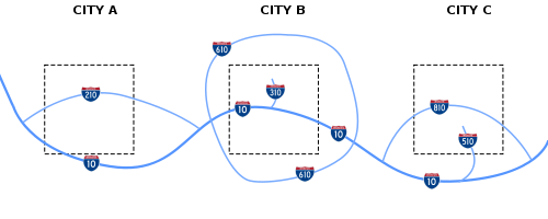
Unlike primary Interstates, three-digit Interstates are signed as either west/east or north/south, depending on the general orientation of the route, without regard to the route number. For some looped Interstate routes, inner/outer directions
Inner/outer directions
Inner/outer directions are labels that identify the direction of travel on opposing lanes of traffic on certain ring roads and beltways. They can be used to sign individual routes that encircle a city or metropolitan area, where east–west and north–south orientations cannot be applied uniformly...
are used as a directional labeling system, as opposed to compass directions.
Mile Markers and Exit Numbers
On one or two digit Interstates, the mile marker numbering always begins at the south state line (for north-south Interstates) or the west state line (for east-west Interstates). If an Interstate originates within a state, the numbering begins from the location where the road begins in the south or west.Three digit Interstates with an even first number that form a complete circumferential (circle) bypass around a city feature Mile Markers that are numbered in a clockwise direction, beginning just west of an Interstate that bisects the circumferential route near a south polar location. In other words, Mile Marker 1 on I-465, a 53-mile circumferential route around Indianapolis, is just west of its junction with I-65 on the south side of Indianapolis (on the South Leg of I-465), and Mile Marker 53 is just east of this same South Leg junction with I-65.
The Exit Number of an interchange is linked to the Mile Markers so that the interchange Exit Number is the same as the number of the nearest Mile Marker.
Business routes
AASHTO defines a category of special routes separate from primary and auxiliary Interstate designations. These routes do not have to comply to Interstate construction standards, but are routes that may be identified and approved by the association. The same route marking policy applies to both U.S. Numbered Highways and Interstate Highways; however, business routeBusiness route
A business route in the United States and Canada is a short special route connected to a parent numbered highway at its beginning, then routed through the central business district of a nearby city or town, and finally reconnecting with the same parent numbered highway again at its...
designations are sometimes used for Interstate Highways. Known as Business Loops and Business Spurs, these routes that principally travel through the corporate limits of a city, passing through the central business district
Central business district
A central business district is the commercial and often geographic heart of a city. In North America this part of a city is commonly referred to as "downtown" or "city center"...
of the city. Business routes are used when the regular route is directed around the city.
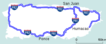
Alaska, Hawaii, and Puerto Rico
Oahu
Oahu or Oahu , known as "The Gathering Place", is the third largest of the Hawaiian Islands and most populous of the islands in the U.S. state of Hawaii. The state capital Honolulu is located on the southeast coast...
, carry the prefix H (e.g., Interstate H-1
Interstate H-1
Interstate H-1 is the busiest Interstate Highway in Hawaii, United States, located on the island of O‘ahu. Despite the number, this is an east–west highway—the 'H'-series numbering reflects the order in which routes were funded and built. H-1 goes from Route 93 in Kapolei to Route 72 in...
), connecting military bases as well as several communities around the island. Both Alaska and Puerto Rico
Puerto Rico
Puerto Rico , officially the Commonwealth of Puerto Rico , is an unincorporated territory of the United States, located in the northeastern Caribbean, east of the Dominican Republic and west of both the United States Virgin Islands and the British Virgin Islands.Puerto Rico comprises an...
have public roads that receive funding from the Interstate program, although these routes are signed with their local designation, not their Interstate Highway designation. These roads are neither planned for, nor built to, official Interstate Highway standards.
Financing
About 70% of the construction and maintenance costs of highways in the U.S. are covered through user fees (net of collection costs), primarily fuel tax
Fuel tax
A fuel tax is an excise tax imposed on the sale of fuel. In most countries the fuel tax is imposed on fuels which are intended for transportation...
es collected by the federal government and state and local governments, and to a much lesser extent tolls collected on toll roads and bridges. The 1956 Highway Trust Fund, established by the Highway Revenue Act, mandated a three-cent-per-gallon tax, soon increased to 4.5 cents. In 1993 the tax reached 18.4 cents per gallon where it remains.
The rest of the costs are borne by general fund receipts, bond issues, and designated property and other taxes. The federal contribution is overwhelmingly from motor vehicle and fuel taxes (93.5% in 2007), as is about 60% of the state contribution. However, local contributions are overwhelmingly from sources other than user fees. The portion of the user fees spent on highways themselves covers about 57% of costs, as approximately one-sixth of the user fees are diverted to other programs, prominently including mass transit. In the eastern United States, large sections of some Interstate Highways planned or built prior to 1956 are operated as toll roads.
As American suburbs have expanded, the costs incurred in maintaining freeway infrastructure have also grown, leaving little in the way of funds for new Interstate construction. This has led to the proliferation of toll roads (turnpikes) as the new method of building limited-access highways in suburban areas. Some Interstates are privately maintained (e.g., VMS maintains I-35 in Texas) to meet rising costs of maintenance and allow state departments of transportation to focus on serving the fastest growing regions in their respective states.
Parts of the system may have to be tolled in the future to meet maintenance and expansion demands, as has been done with adding toll HOV/HOT lanes in cities such as San Diego
San Diego, California
San Diego is the eighth-largest city in the United States and second-largest city in California. The city is located on the coast of the Pacific Ocean in Southern California, immediately adjacent to the Mexican border. The birthplace of California, San Diego is known for its mild year-round...
, Salt Lake City
Salt Lake City, Utah
Salt Lake City is the capital and the most populous city of the U.S. state of Utah. The name of the city is often shortened to Salt Lake or SLC. With a population of 186,440 as of the 2010 Census, the city lies in the Salt Lake City metropolitan area, which has a total population of 1,124,197...
, Minneapolis
Minneapolis, Minnesota
Minneapolis , nicknamed "City of Lakes" and the "Mill City," is the county seat of Hennepin County, the largest city in the U.S. state of Minnesota, and the 48th largest in the United States...
, Houston
Houston, Texas
Houston is the fourth-largest city in the United States, and the largest city in the state of Texas. According to the 2010 U.S. Census, the city had a population of 2.1 million people within an area of . Houston is the seat of Harris County and the economic center of , which is the ...
, Denver
Denver, Colorado
The City and County of Denver is the capital and the most populous city of the U.S. state of Colorado. Denver is a consolidated city-county, located in the South Platte River Valley on the western edge of the High Plains just east of the Front Range of the Rocky Mountains...
, Dallas
Dallas, Texas
Dallas is the third-largest city in Texas and the ninth-largest in the United States. The Dallas-Fort Worth Metroplex is the largest metropolitan area in the South and fourth-largest metropolitan area in the United States...
, Atlanta, and Washington, D.C.
Washington, D.C.
Washington, D.C., formally the District of Columbia and commonly referred to as Washington, "the District", or simply D.C., is the capital of the United States. On July 16, 1790, the United States Congress approved the creation of a permanent national capital as permitted by the U.S. Constitution....
. Although part of the tolling is an effect of the SAFETEA-LU act, which has put an emphasis on toll roads as a means to reduce congestion. Present federal law does not allow for a state to change a freeway section to a tolled section for all traffic.
Toll Interstate Highways
Approximately 2900 miles (4,667.1 km) of toll roads are included in the Interstate Highway System. While federal legislation initially banned the collection of tolls on Interstates, many of the toll roads on the system were either completed or under construction when the Interstate Highway System was established. Since these highways provided logical connections to other parts of the system, they were designated as Interstate highways. CongressUnited States Congress
The United States Congress is the bicameral legislature of the federal government of the United States, consisting of the Senate and the House of Representatives. The Congress meets in the United States Capitol in Washington, D.C....
also decided that it was too costly to either build toll-free Interstates parallel to these toll roads, or directly repay all the bondholders who financed these facilities and remove the tolls.
Toll facilities designated as Interstate highways (such as the Massachusetts Turnpike
Massachusetts Turnpike
The Massachusetts Turnpike is the easternmost stretch of Interstate 90. The Turnpike begins at the western border of Massachusetts in West Stockbridge connecting with the Berkshire Connector portion of the New York State Thruway...
) were typically allowed to continue collecting tolls, but are generally ineligible to receive federal funds for maintenance and improvements. In addition, these toll facilities were grandfathered
Grandfather clause
Grandfather clause is a legal term used to describe a situation in which an old rule continues to apply to some existing situations, while a new rule will apply to all future situations. It is often used as a verb: to grandfather means to grant such an exemption...
from Interstate Highway standards
Interstate Highway standards
Standards for Interstate Highways in the United States are defined by the American Association of State Highway and Transportation Officials in the publication A Policy on Design Standards - Interstate System...
. A notable example is the western approach to the Benjamin Franklin Bridge
Benjamin Franklin Bridge
The Benjamin Franklin Bridge , originally named the Delaware River Bridge, is a suspension bridge across the Delaware River connecting Philadelphia, Pennsylvania and Camden, New Jersey...
in Philadelphia, where Interstate 676
Interstate 676
Interstate 676 is an Interstate Highway that serves as a major thoroughfare through Philadelphia, Pennsylvania, where it is known as the Vine Street Expressway, and Camden, New Jersey, where it is known as the northern segment of the North–South Freeway, as well as the Martin Luther King Jr....
has a surface street section through a historic area.
Policies on toll facilities and Interstate Highways have since changed. The Federal Highway Administration
Federal Highway Administration
The Federal Highway Administration is a division of the United States Department of Transportation that specializes in highway transportation. The agency's major activities are grouped into two "programs," the Federal-aid Highway Program and the Federal Lands Highway Program...
has allowed some states to collect tolls on existing Interstate Highways, while a recent extension of Interstate 376
Interstate 376
Interstate 376 is a major auxiliary route of the Interstate Highway System in the U.S. state of Pennsylvania, located entirely within the Allegheny Plateau. It runs from I-80 near Sharon south and east to a junction with the Pennsylvania Turnpike in Monroeville, after having crossed the Turnpike...
included a section of Pennsylvania Route 60
Pennsylvania Route 60
Pennsylvania Route 60 is a state highway located in the western suburbs of Pittsburgh, Pennsylvania, in the United States. Although the route follows a mostly east–west alignment, it is signed as a north–south highway. The southern terminus of the route is at a pseudo-interchange with U.S...
that was tolled by the Pennsylvania Turnpike Commission
Pennsylvania Turnpike Commission
The Pennsylvania Turnpike Commission was created in 1937 to construct, finance, operate and maintain the Pennsylvania Turnpike. The commission consists of five members. Four members are appointed by the Governor of Pennsylvania. The fifth member is the Pennsylvania Secretary of Transportation.In...
before receiving Interstate designation. Also, newer toll facilities (like the tolled section of I-376, which was built in the early 1990s) must conform to Interstate standards. A new addition of the Manual on Uniform Traffic Control Devices
Manual on Uniform Traffic Control Devices
The Manual on Uniform Traffic Control Devices is a document issued by the Federal Highway Administration of the United States Department of Transportation to specify the standards by which traffic signs, road surface markings, and signals are designed, installed, and used...
in 2009 requires a black-on-yellow "Toll" sign to be placed above the Interstate trailblazer on Interstate Highways that collect tolls.
Legislation passed in 2005 known as SAFETEA-LU, encouraged states to construct new Interstate Highways through "innovative financing" methods. SAFETEA-LU facilitated states to pursue innovative financing by easing the restrictions on building interstates as toll roads, either through state agencies or through public-private partnerships. However, SAFETEA-LU left in place a prohibition of installing tolls on existing toll-free Interstates, and states wishing to toll such routes to finance upgrades and repairs must first seek approval from Congress.
Local maintenance
A few Interstates are maintained by local authorities:- Baltimore, Maryland: Interstate 70Interstate 70Interstate 70 is an Interstate Highway in the United States that runs from Interstate 15 near Cove Fort, Utah, to a Park and Ride near Baltimore, Maryland. It was the first Interstate Highway project in the United States. I-70 approximately traces the path of U.S. Route 40 east of the Rocky...
and Interstate 83Interstate 83Interstate 83 is an Interstate Highway in the eastern United States. Its southern terminus is in Baltimore, Maryland at the Fayette Street exit; its northern terminus is in Harrisburg, Pennsylvania at Interstate 81....
in the city limits - New York City: Small portions of Interstate 278Interstate 278Interstate 278 is an auxiliary Interstate Highway in New Jersey and New York, United States. The road runs from U.S. Route 1/9 in Linden, New Jersey to the Bruckner Interchange in the New York City borough of the Bronx...
- Washington, D.C.Washington, D.C.Washington, D.C., formally the District of Columbia and commonly referred to as Washington, "the District", or simply D.C., is the capital of the United States. On July 16, 1790, the United States Congress approved the creation of a permanent national capital as permitted by the U.S. Constitution....
: Because the city and District are identical, the District maintains the portions of Interstate 66Interstate 66Interstate 66 is an Interstate Highway in the eastern United States. As indicated by its even route number, it runs in an east–west direction. Its western terminus is at Middletown, Virginia, at an intersection with Interstate 81; its eastern terminus is in Washington, D.C., at an...
, Interstate 295Interstate 295 (District of Columbia)Interstate 295 in the U.S. state of Maryland and in Washington, D.C. is a spur route connecting I-95/I-495 and Maryland Route 210 on the Potomac River to Interstate 695 in downtown Washington.-Route description:Although I-295 technically begins at the Capital Beltway , a pair of mainline...
, Interstate 395 and Interstate 695Interstate 695 (District of Columbia)Interstate 695 is the unsigned designation for the 1.39-mile Southeast Freeway in Washington, D.C. It runs from Interstate 395 south of the United States Capitol building east past the north end of Interstate 295 to Pennsylvania Avenue at Barney Circle, just northwest of the John Philip Sousa...
inside the city. - Las VegasLas Vegas, NevadaLas Vegas is the most populous city in the U.S. state of Nevada and is also the county seat of Clark County, Nevada. Las Vegas is an internationally renowned major resort city for gambling, shopping, and fine dining. The city bills itself as The Entertainment Capital of the World, and is famous...
: Much of Interstate 215Interstate 215 (Nevada)The Las Vegas Beltway is the name of the beltway route circling three-quarters of the Las Vegas Valley in southern Nevada. The Las Vegas Beltway carries two numerical designations. Approximately of the beltway, from its southern terminus at Interstate 515/U.S. Route 93/U.S...
is managed by Clark County, NevadaClark County, Nevada-Demographics:As of the census of 2000, there were 1,375,765 people, 512,253 households, and 339,693 families residing within the MSA. The racial makeup of the MSA was 71.6% White , 9.1% Black, 5.7% Asian, 0.8% American Indian and 12.8% of other or mixed race. 22.0% were Hispanic of any race...
's public works department. Only about four miles (6 km) of the freeway were turned over to the NevadaNevadaNevada is a state in the western, mountain west, and southwestern regions of the United States. With an area of and a population of about 2.7 million, it is the 7th-largest and 35th-most populous state. Over two-thirds of Nevada's people live in the Las Vegas metropolitan area, which contains its...
Department of Transportation after the road was completed.
Chargeable and non-chargeable Interstate routes
Interstate Highways financed with federal funds are known as chargeable Interstate routes, and are considered part of the 42000 miles (67,592.3 km) network of highways. Federal laws also allow non-chargeable Interstate routes, highways funded similarly to state and U.S. Highways to be signed as Interstates, if they both meet the Interstate Highway standards and are logical additions or connections to the system. These additions fall under two categories: routes that already meet Interstate standards, and routes not yet upgraded to Interstate standards. Only routes that meet Interstate standards may be signed as Interstates once their proposed number is approved.Signage
The majority of Interstates have exit numberExit number
An exit number is a number assigned to a road junction, usually an exit from a freeway. It is usually marked on the same sign as the destinations of the exit, as well as a sign in the gore....
s. All traffic sign
Traffic sign
Traffic signs or road signs are signs erected at the side of roads to provide information to road users. With traffic volumes increasing over the last eight decades, many countries have adopted pictorial signs or otherwise simplified and standardized their signs to facilitate international travel...
s and lane
Lane
A lane is a part of the roadway within a road marked out for use by a single line of vehicles in such a way as to control and guide drivers for the purpose of reducing traffic conflicts. Most public roads have at least two lanes, one for traffic in each direction, separated by Lane markings...
markings on the Interstates are supposed to be designed in compliance with the Manual on Uniform Traffic Control Devices
Manual on Uniform Traffic Control Devices
The Manual on Uniform Traffic Control Devices is a document issued by the Federal Highway Administration of the United States Department of Transportation to specify the standards by which traffic signs, road surface markings, and signals are designed, installed, and used...
(MUTCD). There are, however, many local and regional variations in signage.
For many years California
California
California is a state located on the West Coast of the United States. It is by far the most populous U.S. state, and the third-largest by land area...
was the only state that did not use an exit numbering system. It was granted an exemption in the 1950s due to having an already largely completed and signed highway system; placing exit number signage across the state was deemed too expensive. California began to incorporate exit numbers on its freeways in 2002 – Interstate, U.S., and state routes alike. Caltrans
California Department of Transportation
The California Department of Transportation is a government department in the U.S. state of California. Its mission is to improve mobility across the state. It manages the state highway system and is actively involved with public transportation systems throughout the state...
commonly installs exit number signage only when a freeway or interchange is built, reconstructed, retrofitted, or repaired to control costs. Most exits along California's Interstates now have exit number signage, particularly in rural areas.
Exit numbers correspond to Interstate mileage markers in most states. on I-19
Interstate 19
Interstate 19 is an intrastate Interstate Highway located entirely within the state of Arizona. I-19 runs from Nogales, roughly 1,500 feet from the Mexican border, to Tucson, at Interstate 10...
in Arizona
Arizona
Arizona ; is a state located in the southwestern region of the United States. It is also part of the western United States and the mountain west. The capital and largest city is Phoenix...
, however, length is measured in kilometers instead of miles because, at the time of construction, a push for the United States to change to a metric system of measurement had gained enough traction that it was mistakenly assumed that all highway measurements would eventually be changed to metric; proximity to metric-using Mexico
Mexico
The United Mexican States , commonly known as Mexico , is a federal constitutional republic in North America. It is bordered on the north by the United States; on the south and west by the Pacific Ocean; on the southeast by Guatemala, Belize, and the Caribbean Sea; and on the east by the Gulf of...
may also have been a factor, as I-19 indirectly connects I-10 to the Mexican Federal Highway
Mexican Federal Highway
Mexican Federal Highways, are roads maintained and built by the federal government of Mexico, through the Secretariat of Communications and Transportation ....
system via surface streets in Nogales
Nogales, Arizona
Nogales is a city in Santa Cruz County, Arizona, United States. The population was 21,017 at the 2010 census. According to 2005 Census Bureau estimates, the population of the city is 20,833. The city is the county seat of Santa Cruz County....
. Mileage count increases from west to east on most even-numbered Interstates; on odd-numbered Interstates mileage count increases from south to north. Some tollways, including the New York State Thruway
New York State Thruway
The New York State Thruway is a system of limited-access highways located within the state of New York in the United States. The system, known officially as the Governor Thomas E. Dewey Thruway for former New York Governor Thomas E. Dewey, is operated by the New York State Thruway Authority and...
and Jane Addams Memorial Tollway, use radial exit numbering schemes. Exits on the New York State Thruway count up from Yonkers
Yonkers, New York
Yonkers is the fourth most populous city in the state of New York , and the most populous city in Westchester County, with a population of 195,976...
traveling north, and then west from Albany. On the Jane Addams Memorial Tollway mileage markers count up from Chicago-O'Hare International Airport traveling west, which is the starting point of the tollway.
As of November 2010 the Illinois State Tollway Authority has redone the mileage markers to be uniform with the rest of the state on I-90 (Jane Addams Memorial/Northwest Tollway) and the I-94 section of the Tri-State Tollway, which previously had matched the I-294 section starting in the south at I-80/I-94/IL Route 394. The tollway is also currently in the process of adding exit number tabs to the exits.
Many northeastern states label exit numbers sequentially, regardless of how many miles have passed between exits. States in which Interstate exits are still numbered sequentially are Connecticut, Delaware, Massachusetts, New Hampshire, New York, Rhode Island, and Vermont; as such, three of the main Interstate highways that remain completely within these states (89, 91, and 93) have interchanges numbered sequentially along their entire routes. Maine, Pennsylvania, Virginia, Georgia and Florida followed this system for a number of years, but since converted to mileage-based exit numbers. Georgia renumbered in 2000, while Maine did so in 2004. The Pennsylvania Turnpike
Pennsylvania Turnpike
The Pennsylvania Turnpike is a toll highway system operated by the Pennsylvania Turnpike Commission in the Commonwealth of Pennsylvania, United States. The three sections of the turnpike system total . The main section extends from Ohio to New Jersey and is long...
uses both mile marker numbers and sequential numbers. Mile marker numbers are used for signage, while sequential numbers are used for numbering interchanges internally. The New Jersey Turnpike
New Jersey Turnpike
The New Jersey Turnpike is a toll road in New Jersey, maintained by the New Jersey Turnpike Authority. According to the International Bridge, Tunnel and Turnpike Association, the Turnpike is the nation's sixth-busiest toll road and is among one of the most heavily traveled highways in the United...
, including the portions which are signed as I-95 and I-78, also has sequential numbering, but other Interstates within New Jersey use mile markers.
I-87 in New York State is numbered in two sections. The section of I-87 that is a part of the New York State Thruway starts in Yonkers (exit 1) and continues north to Albany (exit 24). At Albany, the Thruway turns west and becomes I-90 for exits 25–61. From Albany north to the Canadian border, the exits on I-87 are numbered sequentially from 1 to 44 along the New York State Northway. This often leads to confusion as there is more than one exit on I-87 with the same number. For example, exit 4 on Thruway section of I-87 connects with the Cross County Parkway in Yonkers, but exit 4 on the Northway is the exit for the Albany airport. These two exits share a number but are located 125 miles (201.2 km) apart.
There are four common signage methods on Interstates: One is locating a sign on the ground to the side of the highway, mostly the right, and is used to denote exits, as well as rest areas, motorist services such as gas and lodging, recreational sites, and freeway names. Another method is attaching the sign to an overpass. The two most common methods involve overhead gantries
Gantry (road sign)
A gantry is a traffic sign assembly in which signs are mounted on an overhead support, or railway signals supported....
; they can be mounted either on half-gantries that are located on one side of the highway, like the ground-mounted sign; or full gantries that bridge the entire width of the highway and often show two or more signs.
Interstate shield

Highway shield
A highway shield is a sign denoting the route number of a highway, usually in the form of a symbolic shape with the route number enclosed. As the focus of the sign, the route number is usually the sign's largest element, with other items on the sign rendered in smaller sizes or contrasting colours...
. The sign for Interstate 24
Interstate 24
Interstate 24 is an Interstate Highway in the Midwestern and Southeastern United States. It runs diagonally from Interstate 57 to Chattanooga, Tennessee, at Interstate 75....
is shown to the right. In the original design, the name of the state was displayed above the highway number, but in many states, this area is now left blank. The sign usually measures 36-in (91 cm) high, and is 36-in wide for two-digit Interstates or 45-in (114 cm) for three-digit Interstates.
Interstate business loops and spurs use a special shield in which the red and blue are replaced with green, the word BUSINESS appears instead of INTERSTATE, and the word SPUR or LOOP usually appears above the number. The green shield is employed to mark the main route through a city's central business district, which intersects the associated Interstate highway at one (spur) or both (loop) ends of the business route. The route usually traverses the main thoroughfare(s) of the city's downtown area or other major business district. A city may have more than one Interstate-derived business route, depending on the number of Interstates passing through a city and the number of significant business districts therein.
Over time, the design of the Interstate shield has changed. In 1957, the Interstate shield designed by Texas Highway Department employee Richard Oliver was introduced, the winner of a contest which included 100 entries; at the time, the shield color was a dark navy blue and only 17-in (41 cm) wide. The MUTCD
Manual on Uniform Traffic Control Devices
The Manual on Uniform Traffic Control Devices is a document issued by the Federal Highway Administration of the United States Department of Transportation to specify the standards by which traffic signs, road surface markings, and signals are designed, installed, and used...
standards revised the shield in the 1961, 1970, and 1978 editions.
Statistics
- Heaviest traveled: 390,000 vehicles per day: I-405Interstate 405 (California)Interstate 405 is a major north–south Interstate Highway in Southern California. It is a bypass of Interstate 5, running along the western areas of the Greater Los Angeles Area from Irvine in the south to near San Fernando in the north...
in Los Angeles, CaliforniaCaliforniaCalifornia is a state located on the West Coast of the United States. It is by far the most populous U.S. state, and the third-largest by land area...
(2006 estimate). - Least traveled: 1,800 vehicles per day: I-95Interstate 95 in MaineIn the U.S. state of Maine, Interstate 95 is a long highway running from the New Hampshire border near Kittery, to the Canadian border near Houlton. It is the only two-digit Interstate Highway in Maine...
just north of Houlton, MaineHoulton, MaineHoulton is a town in Aroostook County, Maine, on the United States – Canada border, located at . As of the 2010 census, the town population was 6,123. It is perhaps best known as being at the northern terminus of Interstate 95 and for being the birthplace of Samantha Smith...
to the Canadian border (2001 estimate).
- Highest: 11158 ft (3,401 m): I-70Interstate 70 in ColoradoInterstate 70 is a transcontinental Interstate Highway in the United States, stretching from Cove Fort, Utah to Baltimore, Maryland. In Colorado, the highway traverses an east–west route across the center of the state. In western Colorado, the highway connects the metropolitan areas of Grand...
in the Eisenhower TunnelEisenhower TunnelThe Eisenhower Tunnel, officially the Eisenhower–Johnson Memorial Tunnel, is a dual-bore, four-lane vehicular tunnel approximately west of Denver, Colorado, United States. The tunnel carries Interstate 70 under the Continental Divide in the Rocky Mountains. With a maximum elevation of above sea...
at the Continental DivideContinental DivideThe Continental Divide of the Americas, or merely the Continental Gulf of Division or Great Divide, is the name given to the principal, and largely mountainous, hydrological divide of the Americas that separates the watersheds that drain into the Pacific Ocean from those river systems that drain...
in the ColoradoColoradoColorado is a U.S. state that encompasses much of the Rocky Mountains as well as the northeastern portion of the Colorado Plateau and the western edge of the Great Plains...
Rocky MountainsRocky MountainsThe Rocky Mountains are a major mountain range in western North America. The Rocky Mountains stretch more than from the northernmost part of British Columbia, in western Canada, to New Mexico, in the southwestern United States...
. - Lowest (on land): −52 ft: I-8 at the New RiverNew River (California)The New River flows north from near Cerro Prieto, through the city of Mexicali, Baja California, Mexico, into the United States through the city of Calexico, California towards the Salton Sea...
near Seeley, CaliforniaSeeley, CaliforniaSeeley is a census-designated place in Imperial County, California. Seeley is located west of El Centro, The population was 1,739 at the 2010 census, up from 1,624 at the 2000 census. It is part of the El Centro Metropolitan Area.-History:...
. - Lowest (under water): −107 ft: I-95Interstate 95 in MarylandInterstate 95 in Maryland is a major highway that runs diagonally from northeast to southwest, from Maryland's border with Delaware, to the Woodrow Wilson Bridge, briefly entering the District of Columbia before reaching Virginia...
in the Fort McHenry Tunnel under the Inner HarborInner HarborThe Inner Harbor is a historic seaport, tourist attraction, and iconic landmark of the City of Baltimore, Maryland, United States. Described by the Urban Land Institute in 2009 as “the model for post-industrial waterfront redevelopment around the World.” The Inner Harbor is actually the end of the...
in Baltimore, Maryland.
- Longest: 3020.54 mi (4,861 km): I-90Interstate 90Interstate 90 is the longest Interstate Highway in the United States at . It is the northernmost coast-to-coast interstate, and parallels US 20 for the most part. Its western terminus is in Seattle, at Edgar Martinez Drive S. near Safeco Field and CenturyLink Field, and its eastern terminus is in...
from Seattle, WashingtonSeattle, WashingtonSeattle is the county seat of King County, Washington. With 608,660 residents as of the 2010 Census, Seattle is the largest city in the Northwestern United States. The Seattle metropolitan area of about 3.4 million inhabitants is the 15th largest metropolitan area in the country...
to BostonBostonBoston is the capital of and largest city in Massachusetts, and is one of the oldest cities in the United States. The largest city in New England, Boston is regarded as the unofficial "Capital of New England" for its economic and cultural impact on the entire New England region. The city proper had...
, MassachusettsMassachusettsThe Commonwealth of Massachusetts is a state in the New England region of the northeastern United States of America. It is bordered by Rhode Island and Connecticut to the south, New York to the west, and Vermont and New Hampshire to the north; at its east lies the Atlantic Ocean. As of the 2010...
. - Longest (north–south): 1920 mi (3,090 km): I-95Interstate 95Interstate 95 is the main highway on the East Coast of the United States, running parallel to the Atlantic Ocean from Maine to Florida and serving some of the most populated urban areas in the country, including Boston, Providence, New Haven, New York City, Newark, Philadelphia, Baltimore,...
from the Canadian border to Miami, FloridaMiami, FloridaMiami is a city located on the Atlantic coast in southeastern Florida and the county seat of Miami-Dade County, the most populous county in Florida and the eighth-most populous county in the United States with a population of 2,500,625...
(not counting the gap in New JerseyNew JerseyNew Jersey is a state in the Northeastern and Middle Atlantic regions of the United States. , its population was 8,791,894. It is bordered on the north and east by the state of New York, on the southeast and south by the Atlantic Ocean, on the west by Pennsylvania and on the southwest by Delaware...
to be completedPennsylvania Turnpike/Interstate 95 Interchange ProjectThe Pennsylvania Turnpike/Interstate 95 Interchange Project is a project to build an interchange where Interstate 95 crosses the Pennsylvania Turnpike in Bristol Township, Pennsylvania. This will fill the gap that exists on I-95 through New Jersey due to the cancellation of the Somerset Freeway....
in 2017). - Longest segment between state lines: 879 mi (1,415 km): I-10 in TexasInterstate 10 in TexasInterstate 10 is the major east–west Interstate Highway in the Southern United States. In the U.S. state of Texas, it runs east from El Paso, near the border with New Mexico, through San Antonio and Houston to the border with Louisiana in Orange, Texas....
from the New MexicoNew MexicoNew Mexico is a state located in the southwest and western regions of the United States. New Mexico is also usually considered one of the Mountain States. With a population density of 16 per square mile, New Mexico is the sixth-most sparsely inhabited U.S...
state line near El PasoEl Paso, TexasEl Paso, is a city in and the county seat of El Paso County, Texas, United States, and lies in far West Texas. In the 2010 census, the city had a population of 649,121. It is the sixth largest city in Texas and the 19th largest city in the United States...
to the LouisianaLouisianaLouisiana is a state located in the southern region of the United States of America. Its capital is Baton Rouge and largest city is New Orleans. Louisiana is the only state in the U.S. with political subdivisions termed parishes, which are local governments equivalent to counties...
state line near OrangeOrange, TexasOrange is a city in Orange County, Texas, United States. As of the 2000 census, the city population was 18,643. It is the county seat of Orange County, and is the easternmost city in Texas. Located on the Sabine River at the border with Louisiana, it is part of the Beaumont–Port Arthur...
. - Longest 2-route concurrency: 278.4 mi (448 km): I-80Interstate 80Interstate 80 is the second-longest Interstate Highway in the United States, following Interstate 90. It is a transcontinental artery running from downtown San Francisco, California to Teaneck, New Jersey in the New York City Metropolitan Area...
and I-90Interstate 90Interstate 90 is the longest Interstate Highway in the United States at . It is the northernmost coast-to-coast interstate, and parallels US 20 for the most part. Its western terminus is in Seattle, at Edgar Martinez Drive S. near Safeco Field and CenturyLink Field, and its eastern terminus is in...
; Gary, IndianaGary, IndianaGary is a city in Lake County, Indiana, United States. The city is in the southeastern portion of the Chicago metropolitan area and is 25 miles from downtown Chicago. The population is 80,294 at the 2010 census, making it the seventh-largest city in the state. It borders Lake Michigan and is known...
to Elyria, OhioElyria, Ohio-Community:Elyria has an extensive, although financially burdened, community food pantry and "Hot Meals" program administered through the Second Harvest Food Bank and several churches Elyria is served by Elyria Memorial Hospital.-Recreation and parks:...
. - Longest 3-route concurrency: 30 mi (48 km): I-39, I-90, and I-94; PortagePortage, WisconsinPortage is a city in and the county seat of Columbia County, Wisconsin, United States. The population was 10,662 at the 2010 census making it the largest city in Columbia County...
to Madison, WisconsinMadison, WisconsinMadison is the capital of the U.S. state of Wisconsin and the county seat of Dane County. It is also home to the University of Wisconsin–Madison....
. - Longest 4-route concurrency: 0.2 mi (0.321868 km): I-44, I-55, I-64, I-70; St. Louis, MissouriSt. Louis, MissouriSt. Louis is an independent city on the eastern border of Missouri, United States. With a population of 319,294, it was the 58th-largest U.S. city at the 2010 U.S. Census. The Greater St...
on the Poplar Street BridgePoplar Street BridgeThe Poplar Street Bridge, officially the Bernard F. Dickmann Bridge, completed in 1967, is a long deck girder bridge across the Mississippi River between St. Louis, Missouri and East St. Louis, Illinois...
. Note: I-44 designation ends at IllinoisIllinoisIllinois is the fifth-most populous state of the United States of America, and is often noted for being a microcosm of the entire country. With Chicago in the northeast, small industrial cities and great agricultural productivity in central and northern Illinois, and natural resources like coal,...
state line. - Longest beltway: 83.71 mi (135 km): Interstate 275Interstate 275 (Ohio)Interstate 275 is an loop in Ohio, Indiana, and Kentucky that forms a complete beltway around the Cincinnati, Ohio area. It is the only auxiliary interstate that enters three states, including one state that the parent route does not enter . It is the longest loop interstate highway in the United...
surrounding Cincinnati. - Longest intrastate: 333.49 mi (537 km): I-87Interstate 87Interstate 87 is a Interstate Highway located entirely within New York State in the United States of America. I-87 is the longest intrastate Interstate highway in the Interstate Highway System. Its southern end is at the Bronx approaches of the Robert F. Kennedy Bridge in New York City...
in New York. - Shortest segment between state-lines: 453 ft (138.1 m): I-95Interstate 95Interstate 95 is the main highway on the East Coast of the United States, running parallel to the Atlantic Ocean from Maine to Florida and serving some of the most populated urban areas in the country, including Boston, Providence, New Haven, New York City, Newark, Philadelphia, Baltimore,...
/Capital Beltway on the Woodrow Wilson BridgeWoodrow Wilson BridgeThe Woodrow Wilson Memorial Bridge is a bascule bridge that spans the Potomac River between the independent city of Alexandria, Virginia and Oxon Hill in Prince George's County, Maryland, United States. While over the water near the Virginia shore, it crosses the southern tip of the District of...
across the Potomac RiverPotomac RiverThe Potomac River flows into the Chesapeake Bay, located along the mid-Atlantic coast of the United States. The river is approximately long, with a drainage area of about 14,700 square miles...
where it briefly crosses the southernmost tip of the District of Columbia between its lines with MarylandMarylandMaryland is a U.S. state located in the Mid Atlantic region of the United States, bordering Virginia, West Virginia, and the District of Columbia to its south and west; Pennsylvania to its north; and Delaware to its east...
and VirginiaVirginiaThe Commonwealth of Virginia , is a U.S. state on the Atlantic Coast of the Southern United States. Virginia is nicknamed the "Old Dominion" and sometimes the "Mother of Presidents" after the eight U.S. presidents born there...
. - Shortest (unsigned): 0.7 mi (1.1 km): I-878, a portion of New York State Route 878New York State Route 878New York State Route 878 is a state highway in the U.S. state of New York, forming the Nassau Expressway. The route exists in two sections connected by Rockaway Boulevard and Rockaway Turnpike, maintained in part by New York City, the New York State Department of Transportation , and Nassau...
adjacent to John F. Kennedy International AirportJohn F. Kennedy International AirportJohn F. Kennedy International Airport is an international airport located in the borough of Queens in New York City, about southeast of Lower Manhattan. It is the busiest international air passenger gateway to the United States, handling more international traffic than any other airport in North...
in Queens, New York. - Shortest (signed): 1.06 mi (1.71 km): I-375Interstate 375 (Michigan)The unsigned Business Spur Interstate 375 , which is long, continues west on Jefferson Avenue from the southern end of I-375, ending at the entrance to the Detroit–Windsor Tunnel at Randolph Street . Jefferson Avenue past that intersection is M-10, quickly becoming the Lodge Freeway. BS I-375 runs...
in downtown Detroit, MichiganMichiganMichigan is a U.S. state located in the Great Lakes Region of the United States of America. The name Michigan is the French form of the Ojibwa word mishigamaa, meaning "large water" or "large lake"....
. - Shortest (2-digit): 17.62 mi (28.4 km): I-97Interstate 97Interstate 97 is an intrastate Interstate Highway located entirely within Anne Arundel County, Maryland, United States. It runs from Annapolis at the overlapped section of US 50, US 301, and the unsigned I-595 to Baltimore at the city's beltway...
from Baltimore to Annapolis, MarylandAnnapolis, MarylandAnnapolis is the capital of the U.S. state of Maryland, as well as the county seat of Anne Arundel County. It had a population of 38,394 at the 2010 census and is situated on the Chesapeake Bay at the mouth of the Severn River, south of Baltimore and about east of Washington, D.C. Annapolis is...
. - Shortest highway that crosses a state line: 2.78 mi (4.47 km): I-535Interstate 535Interstate 535 is a long Interstate Highway spur route of Interstate 35 in Minnesota and Wisconsin, in the United States. It is paired with U.S...
from Duluth, MinnesotaDuluth, MinnesotaDuluth is a port city in the U.S. state of Minnesota and is the county seat of Saint Louis County. The fourth largest city in Minnesota, Duluth had a total population of 86,265 in the 2010 census. Duluth is also the second largest city that is located on Lake Superior after Thunder Bay, Ontario,...
to Superior, WisconsinSuperior, WisconsinSuperior is a city in and the county seat of Douglas County, Wisconsin, United States. The population was 26,960 at the 2010 census. Located at the junction of U.S. Highways 2 and 53, it is north of and adjacent to both the Village of Superior and the Town of Superior.Superior is at the western...
. - Shortest (2-digit) highway that crosses a state line: 76.2 mi (122.63 km): I-66Interstate 66Interstate 66 is an Interstate Highway in the eastern United States. As indicated by its even route number, it runs in an east–west direction. Its western terminus is at Middletown, Virginia, at an intersection with Interstate 81; its eastern terminus is in Washington, D.C., at an...
from Strasburg, VA to Washington, DC.
- Widest (most grade-separated access-controlled through lanes): 21 lanes—I-5Interstate 5 in CaliforniaInterstate 5 is a major north–south route of the Interstate Highway System in the U.S. state of California. It begins at the Mexico – United States border at the San Ysidro crossing, goes north across the length of California and crosses into Oregon south of the Medford-Ashland metropolitan...
along a 2 miles (3.2 km) section between I-805Interstate 805Interstate 805 is a major north–south Interstate Highway in Southern California. It is a bypass of Interstate 5, running along the eastern areas of the Greater San Diego area from San Ysidro near the Mexico–U.S...
and SR-56California State Route 56State Route 56 runs from Interstate 5 in the Carmel Valley neighborhood of San Diego to Interstate 15. Route 56 was originally planned in 1964 to connect to the north end of State Route 125 and continue east to State Route 67, but the city of Poway worked to make sure that would not be possible...
in San Diego, which was completed in April 2007. - Widest (widest median): more than a mile—I-8 through the In-Ko-Pah grade in California at about a mile wide, I-84Interstate 84 in OregonIn the U.S. state of Oregon, Interstate 84 travels east–west, following the Columbia River and the rough path of the old Oregon Trail from Portland east to Idaho. For this reason, it is also known as most of the Columbia River Highway No. 2 and all of the Old Oregon Trail Highway No. 6 . It...
through the Cabbage Hill grade in Oregon at 2 miles (3.2 km) wide, and I-24Interstate 24 in TennesseeIn the U.S. state of Tennessee, Interstate 24 runs from Clarksville to Chattanooga via Nashville. Just west of Chattanooga, I-24 drops into Georgia's Dade County for before reentering Tennessee....
through the Monteagle grade in Tennessee at 1.75 miles (2.8 km) wide. - Narrowest: 2 lanes—I-93 in New HampshireNew HampshireNew Hampshire is a state in the New England region of the northeastern United States of America. The state was named after the southern English county of Hampshire. It is bordered by Massachusetts to the south, Vermont to the west, Maine and the Atlantic Ocean to the east, and the Canadian...
where it runs through Franconia Notch State ParkFranconia Notch State ParkFranconia Notch State Park is located in the White Mountains in northern New Hampshire and straddles of Interstate 93 as it passes through Franconia Notch, a mountain pass between the Kinsman Range and Franconia Range...
where it also lacks breakdown lanes and I-81Interstate 81 in New YorkInterstate 81 is a part of the Interstate Highway System that runs from Dandridge, Tennessee, to the Canada – United States border at Wellesley Island in New York. In the U.S. state of New York, I-81 extends from the Pennsylvania state line southeast of Binghamton to the Canadian border...
on the southern span of the Thousand Islands BridgeThousand Islands BridgeThe Thousand Islands Bridge is an international bridge system over the Saint Lawrence River connecting northern New York in the United States with southeastern Ontario in Canada. Constructed in 1937, with additions in 1959, the bridges span the United States-Canada border in the middle of the...
, are the only instances of a two lane highway – also called a Super-2Super twoA super two, super two-lane highway or wide two lane is a two-lane surface road built to high standards, typically including partial control of access, occasional passing lanes and hard shoulders...
parkway – on the Interstate system.
- Most states served by an Interstate: 15 states plus the District of Columbia: I-95Interstate 95Interstate 95 is the main highway on the East Coast of the United States, running parallel to the Atlantic Ocean from Maine to Florida and serving some of the most populated urban areas in the country, including Boston, Providence, New Haven, New York City, Newark, Philadelphia, Baltimore,...
through FLInterstate 95 in FloridaInterstate 95 is the main Interstate Highway on the east coast of the United States; it serves the Atlantic coast of Florida. It begins at a partial interchange with U.S. Highway 1 just south of downtown Miami, and heads north past Daytona Beach and Jacksonville to the Georgia state line at the St...
, GAInterstate 95 in GeorgiaInterstate 95, the main Interstate Highway on the east coast of the United States, serves the Atlantic coast of Georgia. It begins at the St. Marys River at the Florida state line north of Jacksonville and heads north past the border of South Carolina at the Savannah River...
, SCInterstate 95 in South CarolinaInterstate 95 is a major Interstate Highway, running along the East Coast of the United States from Florida to Maine. In South Carolina, I-95 runs approximately parallel to the Atlantic Ocean shore although about inland, from Hardeeville in the south to Dillon in the northeast.-Route...
, NCInterstate 95 in North CarolinaInterstate 95 is a major Interstate Highway, running along the East Coast of the United States from Florida to Maine. In North Carolina, I-95 runs diagonally across the eastern third of the state, from Rowland in the southwest to Roanoke Rapids in the northeast of the Inner Banks.-Route...
, VAInterstate 95 in VirginiaIn the Commonwealth of Virginia, Interstate 95 runs through the state. It runs concurrently for with Interstate 64 in Richmond, and meets the northern terminus of Interstate 85 in Petersburg. Though Interstate 95 was originally planned to go straight through Washington, D.C., it was instead...
, DC, MDInterstate 95 in MarylandInterstate 95 in Maryland is a major highway that runs diagonally from northeast to southwest, from Maryland's border with Delaware, to the Woodrow Wilson Bridge, briefly entering the District of Columbia before reaching Virginia...
, DEInterstate 95 in DelawareIn Delaware, Interstate 95 runs diagonally from the border with Maryland northeast to the border with Pennsylvania. Between the Maryland state line and exit 5, I-95 is also designated as the Delaware Turnpike and the John F. Kennedy Memorial Highway. Along with its auxiliaries, I-95 is the only...
, PAInterstate 95 in PennsylvaniaInterstate 95 is an Interstate highway running from Miami, Florida north to Houlton, Maine. In the U.S. state of Pennsylvania, the route is known by many as the Delaware Expressway, but is officially named The Vietnam Veterans Memorial Highway. and locally known as "95"...
, NJInterstate 95 in New JerseyInterstate 95 is a major Interstate Highway that traverses the full extent of the East Coast of the United States, from Florida to Maine...
, NYInterstate 95 in New YorkInterstate 95 is a part of the Interstate Highway System that runs from Miami, Florida, to the Canada – United States border near Houlton, Maine. In the U.S. state of New York, I-95 extends from the George Washington Bridge in New York City to the Connecticut state line at Port Chester...
, CTInterstate 95 in ConnecticutInterstate 95, the main north–south Interstate Highway on the East Coast of the United States, runs in a general east–west compass direction for 111.57 miles in Connecticut from the Rhode Island state line to the New York State line. I-95 Southbound from East Lyme to the New York State...
, RIInterstate 95 in Rhode IslandInterstate 95, the main north–south Interstate Highway on the east coast of the United States, runs generally southwest-northeast through the U.S. state of Rhode Island. It runs from the border with Connecticut near Westerly through Warwick and Providence and to the Massachusetts state line...
, MAInterstate 95 in MassachusettsInterstate 95 is the main highway on the East Coast of the United States, paralleling the Atlantic Ocean from Florida to Maine. The Massachusetts portion of the highway enters from the state of Rhode Island in Attleboro and travels in a northeasterly direction to the junction with Route 128 in...
, NHInterstate 95 in New HampshireInterstate 95, the main Interstate Highway on the east coast of the United States, cuts through the Seacoast Region of New Hampshire. The majority of it, from the Massachusetts border to the Portsmouth Circle in Portsmouth, is the 14.29-mile Blue Star Turnpike or New Hampshire Turnpike, a toll...
, and MEInterstate 95 in MaineIn the U.S. state of Maine, Interstate 95 is a long highway running from the New Hampshire border near Kittery, to the Canadian border near Houlton. It is the only two-digit Interstate Highway in Maine...
. - Most Interstates in a state: 29 routes: New York, totaling 1674.73 mi (2,695 km).
- Most Primary Interstates in a State: 12 routes: IllinoisIllinoisIllinois is the fifth-most populous state of the United States of America, and is often noted for being a microcosm of the entire country. With Chicago in the northeast, small industrial cities and great agricultural productivity in central and northern Illinois, and natural resources like coal,...
, PennsylvaniaPennsylvaniaThe Commonwealth of Pennsylvania is a U.S. state that is located in the Northeastern and Mid-Atlantic regions of the United States. The state borders Delaware and Maryland to the south, West Virginia to the southwest, Ohio to the west, New York and Ontario, Canada, to the north, and New Jersey to... - Most Interstate mileage in a state: 3233.45 mi (5,204 km): TexasTexasTexas is the second largest U.S. state by both area and population, and the largest state by area in the contiguous United States.The name, based on the Caddo word "Tejas" meaning "friends" or "allies", was applied by the Spanish to the Caddo themselves and to the region of their settlement in...
, in 17 different routes.
See also
- Adopt a HighwayAdopt a HighwayThe Adopt-a-Highway program, also known as Sponsor-a-Highway , is a promotional campaign undertaken by U.S. states, Provinces and Territories of Canada, and national governments outside North America to encourage volunteers to keep a section of a highway free from litter...
- Highway patrolHighway patrolA highway patrol is either a police unit created primarily for the purpose of overseeing and enforcing traffic safety compliance on roads and highways, or a detail within an existing local or regional police agency that is primarily concerned with such duties.Duties of highway patrols or traffic...
- International E-road networkInternational E-road networkThe international E-road network is a numbering system for roads in Europe developed by the United Nations Economic Commission for Europe . The network is numbered from E 1 up and its roads cross national borders...
(Europe) - List of highway systems with full control of access and no cross traffic
- List of roads and highways
- National Highway System (United States)National Highway System (United States)The National Highway System is a network of strategic highways within the United States, including the Interstate Highway System and other roads serving major airports, ports, rail or truck terminals, railway stations, pipeline terminals and other strategic transport facilities.Individual states...
- National Trunk Highway System (China)
- Non-motorized access on freewaysNon-motorized access on freewaysThe concept of a freeway has resulted in highways in the USA with engineering features such as long sight-distances, wide marked lanes and the absence of cross traffic...
- ParkwayParkwayThe term parkway has several distinct principal meanings and numerous synonyms around the world, for either a type of landscaped area or a type of road.Type of landscaped area:...
- Roads and expressways in South KoreaRoads and expressways in South KoreaExpressways in South Korea were originally numbered in order of construction. Since August 24, 2001, they have been numbered in a scheme somewhat similar to that of the Interstate Highway System in the United States; the icons of the South Korean highways are similar to the US red, white and...
, signage and numbering heavily influenced by Interstate Highway System - Transportation in the United StatesTransportation in the United StatesTransportation in the United States is facilitated by road, air, rail, and water networks. The vast majority of passenger travel occurs by automobile for shorter distances, and airplane for longer distances...
- United States Numbered HighwaysUnited States Numbered HighwaysThe system of United States Numbered Highways is an integrated system of roads and highways in the United States numbered within a nationwide grid...
External links
- Interstate Highway information
- FHWA Route Log and Finder List
- FHWA Turner-Fairbank Highway Research Center
- U.S. President's Advisory Committee on a National Highway System Records, 1954-1955, Dwight D. Eisenhower Presidential Library
- Documents regarding the Interstate Highway System, Dwight D. Eisenhower Presidential Library
- NOW on PBS Keep on Trucking? "Would you pay more in taxes to fix roads and rail?"
- "The Eisenhower Interstate System (Simplified)," schematic diagram by Chris Yates