

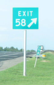
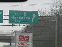
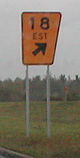
Exit number
Encyclopedia
Gore (road)
A gore, gore point, or gore zone is a triangular piece of land found where roads merge or split. When two roads merge, the area is sometimes referred to as a merge nose...
.
Exit numbers typically reset at political borders such as state
U.S. state
A U.S. state is any one of the 50 federated states of the United States of America that share sovereignty with the federal government. Because of this shared sovereignty, an American is a citizen both of the federal entity and of his or her state of domicile. Four states use the official title of...
lines.
Some non-freeways use exit numbers. Typically these are rural roads built to expressway
Limited-access road
A limited-access road known by various terms worldwide, including limited-access highway, dual-carriageway and expressway, is a highway or arterial road for high-speed traffic which has many or most characteristics of a controlled-access highway , including limited or no access to adjacent...
standards, and either only the actual exits are numbered, or the at-grade intersections are also numbered. An extreme case of this is in New York City
New York City
New York is the most populous city in the United States and the center of the New York Metropolitan Area, one of the most populous metropolitan areas in the world. New York exerts a significant impact upon global commerce, finance, media, art, fashion, research, technology, education, and...
, where the Grand Concourse
Grand Concourse (Bronx)
The Grand Concourse is a major thoroughfare in the borough of the Bronx in New York City...
and Linden Boulevard
Linden Boulevard
Linden Boulevard is a boulevard in New York City. It starts off at Flatbush Avenue in Brooklyn and stretches through both Brooklyn and Queens. This boulevard, especially the area of Cambria Heights between Springfield Boulevard and the Nassau County line represents a smaller version of shopping...
were given sequential numbers, one per intersection. A milder version of this has been recently used on the West Side Highway
West Side Highway
The West Side Highway is a mostly surface section of New York State Route 9A that runs from West 72nd Street along the Hudson River to the southern tip of Manhattan. It replaced the West Side Elevated Highway, built between 1929 and 1951, which was shut down in 1973 due to neglect and lack of...
, also in New York, where only the major intersections are numbered (possibly to match the planned exits on the cancelled Westway freeway). Another case is the Nanaimo Parkway in Nanaimo, British Columbia
Nanaimo, British Columbia
Nanaimo is a city on Vancouver Island in British Columbia, Canada. It has been dubbed the "Bathtub Racing Capital of the World" and "Harbour City". Nanaimo is also sometimes referred to as the "Hub City" because of its central location on Vancouver Island and due to the layout of the downtown...
carrying Highway 19, where all exits are numbered though all except one are at-grade intersections. Some other intersections on Highway 19 outside Nanaimo are also given numbers.
As a means of educating motorists, some state highway
State highway
State highway, state road or state route can refer to one of three related concepts, two of them related to a state or provincial government in a country that is divided into states or provinces :#A...
maps include a brief explanation of the exit numbering system on an inset. Iowa DOT
Iowa Department of Transportation
In the U.S. state of Iowa, the Iowa Department of Transportation is the state government organization responsible for the organization, construction, and maintenance of the primary highway system...
maps from the 1980s and 1990s included a picture or drawing of a milepost
Milestone
A milestone is one of a series of numbered markers placed along a road or boundary at intervals of one mile or occasionally, parts of a mile. They are typically located at the side of the road or in a median. They are alternatively known as mile markers, mileposts or mile posts...
and briefly described how Iowa had included milepost references near interchanges on the map.
Sequential numbers
Cloverleaf interchange
A cloverleaf interchange is a two-level interchange in which left turns, reverse direction in left-driving regions, are handled by ramp roads...
s, where two sets of ramps connect two roads, the separate exit ramps are often suffixed with a letter, such as 15A and 15B. Some older schemes assigned directional letters (15N for northbound, 15S for southbound) In France
France
The French Republic , The French Republic , The French Republic , (commonly known as France , is a unitary semi-presidential republic in Western Europe with several overseas territories and islands located on other continents and in the Indian, Pacific, and Atlantic oceans. Metropolitan France...
and Japan
Japan
Japan is an island nation in East Asia. Located in the Pacific Ocean, it lies to the east of the Sea of Japan, China, North Korea, South Korea and Russia, stretching from the Sea of Okhotsk in the north to the East China Sea and Taiwan in the south...
, decimals are used, as in 15.1 and 15.2.
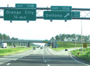
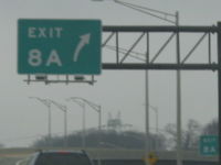
When new exits are added to a road between two existing exits, the new exit is often given a number with a letter suffix, for example exit 15A may be assigned to a new exit between exit 15 and exit 16. On the New York State Thruway
New York State Thruway
The New York State Thruway is a system of limited-access highways located within the state of New York in the United States. The system, known officially as the Governor Thomas E. Dewey Thruway for former New York Governor Thomas E. Dewey, is operated by the New York State Thruway Authority and...
, an exit was added between 21 and 21A, leading to the sequence 21 - 21B - 21A - 22. In Florida
Florida
Florida is a state in the southeastern United States, located on the nation's Atlantic and Gulf coasts. It is bordered to the west by the Gulf of Mexico, to the north by Alabama and Georgia and to the east by the Atlantic Ocean. With a population of 18,801,310 as measured by the 2010 census, it...
, some new exits got the suffix C, so that if it had or acquired separate exits for the two directions they would be 15CA and 15CB rather than 15AA and 15AB, and also if the original exit with the same number got separate ramps per direction they would be (for example) 15A and 15B instead of having to renumber the new interchange.
Occasionally sequential exits are renumbered due to added exits. For instance, the Hutchinson River Parkway
Hutchinson River Parkway
The Hutchinson River Parkway is a north–south parkway in southern New York, United States. It extends for from the massive Bruckner Interchange in the Throgs Neck section of the Bronx to the New York – Connecticut state line at Rye Brook...
in New York
New York
New York is a state in the Northeastern region of the United States. It is the nation's third most populous state. New York is bordered by New Jersey and Pennsylvania to the south, and by Connecticut, Massachusetts and Vermont to the east...
was renumbered so that its northernmost exit, 27, became 30. However, the Merritt Parkway
Merritt Parkway
The Merritt Parkway is a historic limited-access parkway in Fairfield County, Connecticut. The parkway is known for its scenic layout, its uniquely styled signage, and the architecturally elaborate overpasses along the route. It is designated as a National Scenic Byway and is also listed in the...
, which continued its exit numbers in Connecticut
Connecticut
Connecticut is a state in the New England region of the northeastern United States. It is bordered by Rhode Island to the east, Massachusetts to the north, and the state of New York to the west and the south .Connecticut is named for the Connecticut River, the major U.S. river that approximately...
, was not renumbered, and the sequence now jumps from 30 down to 27 (the interchange on the state line had two exit 27s, and now has exits 30 and 27).
The Atlantic City-Brigantine Connector
Atlantic City-Brigantine Connector
The Atlantic City – Brigantine Connector, also known as the Atlantic City Expressway Connector or simply the Brigantine Connector, is a highway connector in Atlantic City, New Jersey. It connects the Atlantic City Expressway with Route 87, which leads into Brigantine, a beach resort along the...
in Atlantic City, New Jersey
Atlantic City, New Jersey
Atlantic City is a city in Atlantic County, New Jersey, United States, and a nationally renowned resort city for gambling, shopping and fine dining. The city also served as the inspiration for the American version of the board game Monopoly. Atlantic City is located on Absecon Island on the coast...
approached the previous problem in a different way by using letters without numbers for its exits. The connector was appended to the eastern end of the Atlantic City Expressway
Atlantic City Expressway
The Atlantic City Expressway is a , controlled-access toll road in New Jersey, managed and operated by the South Jersey Transportation Authority...
, thus extending the highway from mile zero. Assigning the connector numbered exits would have required re-numbering all the exits on the entire expressway.
Eleven U.S. states use sequential numbering schemes, although amendments to the Manual on Uniform Traffic Control Devices
Manual on Uniform Traffic Control Devices
The Manual on Uniform Traffic Control Devices is a document issued by the Federal Highway Administration of the United States Department of Transportation to specify the standards by which traffic signs, road surface markings, and signals are designed, installed, and used...
require them to transition to distance-based numbering.
Distance-based numbers

Distance
Distance is a numerical description of how far apart objects are. In physics or everyday discussion, distance may refer to a physical length, or an estimation based on other criteria . In mathematics, a distance function or metric is a generalization of the concept of physical distance...
-based (mile- or kilometre-based) exit numbers. The first mile-based system known was implemented on the Garden State Parkway
Garden State Parkway
The Garden State Parkway is a 172.4-mile limited-access toll parkway that stretches the length of New Jersey from the New York line at Montvale, New Jersey, to Cape May at New Jersey's southernmost tip. Its name refers to New Jersey's nickname, the "Garden State." Most New Jersey residents refer...
in New Jersey in the late 1950s. Michigan also implemented mile-based junction numbers on Interstate 94 in the 1960s. In this system, the number of miles from the beginning of the highway to the exit is used as the exit number. If two exits end up with the same number, the numbers are sometimes slightly modified; this is often impossible and exits are given sequential or directional suffixes, just as with sequential numbers.
An exit can be numbered by where the exit in the direction of increased mileage leaves the freeway, or by where the road that the exit serves crosses the freeway (which is occasionally ambiguous). The US MUTCD recommends the latter. From this number, the integer
Integer
The integers are formed by the natural numbers together with the negatives of the non-zero natural numbers .They are known as Positive and Negative Integers respectively...
exit number can be determined by rounding up, rounding down, or rounding to the nearest integer. Many jurisdictions prefer to avoid an exit 0. To this end, the numbers are either rounded up to get the exit number, or any exit that would get the number 0 is instead numbered 1. Examples of highways with an exit 0 are British Columbia Highway 1 on the B.C. mainland, Interstate 10
Interstate 10
Interstate 10 is the fourth-longest Interstate Highway in the United States, after I-90, I-80, and I-40. It is the southernmost east–west, coast-to-coast Interstate Highway, although I-4 and I-8 are further south. It stretches from the Pacific Ocean at State Route 1 in Santa Monica,...
in El Paso, Texas
El Paso, Texas
El Paso, is a city in and the county seat of El Paso County, Texas, United States, and lies in far West Texas. In the 2010 census, the city had a population of 649,121. It is the sixth largest city in Texas and the 19th largest city in the United States...
along the New Mexico
New Mexico
New Mexico is a state located in the southwest and western regions of the United States. New Mexico is also usually considered one of the Mountain States. With a population density of 16 per square mile, New Mexico is the sixth-most sparsely inhabited U.S...
-Texas
Texas
Texas is the second largest U.S. state by both area and population, and the largest state by area in the contiguous United States.The name, based on the Caddo word "Tejas" meaning "friends" or "allies", was applied by the Spanish to the Caddo themselves and to the region of their settlement in...
border, Interstate 70
Interstate 70
Interstate 70 is an Interstate Highway in the United States that runs from Interstate 15 near Cove Fort, Utah, to a Park and Ride near Baltimore, Maryland. It was the first Interstate Highway project in the United States. I-70 approximately traces the path of U.S. Route 40 east of the Rocky...
in Wheeling, West Virginia
Wheeling, West Virginia
Wheeling is a city in Ohio and Marshall counties in the U.S. state of West Virginia; it is the county seat of Ohio County. Wheeling is the principal city of the Wheeling Metropolitan Statistical Area...
along the West Virginia
West Virginia
West Virginia is a state in the Appalachian and Southeastern regions of the United States, bordered by Virginia to the southeast, Kentucky to the southwest, Ohio to the northwest, Pennsylvania to the northeast and Maryland to the east...
-Ohio
Ohio
Ohio is a Midwestern state in the United States. The 34th largest state by area in the U.S.,it is the 7th‑most populous with over 11.5 million residents, containing several major American cities and seven metropolitan areas with populations of 500,000 or more.The state's capital is Columbus...
border, Interstate 90
Interstate 90
Interstate 90 is the longest Interstate Highway in the United States at . It is the northernmost coast-to-coast interstate, and parallels US 20 for the most part. Its western terminus is in Seattle, at Edgar Martinez Drive S. near Safeco Field and CenturyLink Field, and its eastern terminus is in...
on the Montana side of the Idaho
Idaho
Idaho is a state in the Rocky Mountain area of the United States. The state's largest city and capital is Boise. Residents are called "Idahoans". Idaho was admitted to the Union on July 3, 1890, as the 43rd state....
-Montana
Montana
Montana is a state in the Western United States. The western third of Montana contains numerous mountain ranges. Smaller, "island ranges" are found in the central third of the state, for a total of 77 named ranges of the Rocky Mountains. This geographical fact is reflected in the state's name,...
border, and Interstate 65
Interstate 65
Interstate 65 is a major Interstate Highway in the United States. The southern terminus is located at an intersection with Interstate 10 in Mobile, Alabama, and its northern terminus is at an interchange with Interstate 90 , U.S. Route 12, and U.S...
in two locations: at its terminus with Interstate 10
Interstate 10
Interstate 10 is the fourth-longest Interstate Highway in the United States, after I-90, I-80, and I-40. It is the southernmost east–west, coast-to-coast Interstate Highway, although I-4 and I-8 are further south. It stretches from the Pacific Ocean at State Route 1 in Santa Monica,...
in Mobile, Alabama
Mobile, Alabama
Mobile is the third most populous city in the Southern US state of Alabama and is the county seat of Mobile County. It is located on the Mobile River and the central Gulf Coast of the United States. The population within the city limits was 195,111 during the 2010 census. It is the largest...
, and just north of the Ohio River
Ohio River
The Ohio River is the largest tributary, by volume, of the Mississippi River. At the confluence, the Ohio is even bigger than the Mississippi and, thus, is hydrologically the main stream of the whole river system, including the Allegheny River further upstream...
in Jeffersonville, Indiana
Jeffersonville, Indiana
Jeffersonville is a city in Clark County, Indiana, along the Ohio River. Locally, the city is often referred to by the abbreviated name Jeff. It is directly across the Ohio River to the north of Louisville, Kentucky along I-65. The population was 44,953 at the 2010 census...
.
In areas that use the metric system
Metric system
The metric system is an international decimalised system of measurement. France was first to adopt a metric system, in 1799, and a metric system is now the official system of measurement, used in almost every country in the world...
, distance-based numbers are by kilometre rather than mile. A few highways, such as Delaware Route 1 and Interstate 19
Interstate 19
Interstate 19 is an intrastate Interstate Highway located entirely within the state of Arizona. I-19 runs from Nogales, roughly 1,500 feet from the Mexican border, to Tucson, at Interstate 10...
, have been renumbered from miles to kilometres, even in areas that typically use miles. I-19 has received funding for the distances to be changed back to miles.
Distance-based numbers have several advantages. They match the mileposts along the road; it is thus easy to calculate how far one has to go. Additionally, most new exits don't need letter suffixes, as in a sequential system. Two other advantages are outlined in this guide.
Suffixes are required when the same mile of highway contains multiple exits; an extreme example is along several different highways in Kansas City, Missouri
Kansas City, Missouri
Kansas City, Missouri is the largest city in the U.S. state of Missouri and is the anchor city of the Kansas City Metropolitan Area, the second largest metropolitan area in Missouri. It encompasses in parts of Jackson, Clay, Cass, and Platte counties...
, where there are 23 exits in the four-mile long "Alphabet Loop"
Downtown freeway loop (Kansas City)
The downtown loop, also nicknamed the "Alphabet Loop", is a complex layout of highways in downtown Kansas City, Missouri involving 23 exits, four Interstate Highways, four U.S. Highways and numerous city streets...
, designated 2A through 2Y (the I and O suffixes are skipped because of their resemblance to 1 and 0 respectively). However, for calculation purposes, suffixed exits in a distance-based system can be approximated by using the number without a suffix.
On the other hand, there are some disadvantages to changing from a sequential system. Businesses and motorists have to adapt to the changes, and it costs money to replace the signs (as well as for temporary "old exit" tabs to ease the transition). Due to a kilometre being 0.621 miles, the probability of multiple exits within the same kilometre is less than the probability of multiple exits within the same mile.
Australia
Australia uses distance-based numbering on a section of the M3/M1 Pacific MotorwayPacific Motorway
The Pacific Motorway is a 100 km long motorway in Australia between Brisbane, Queensland, and the New South Wales-Queensland border at Tweed Heads. The motorway starts at Coronation Drive at Milton in Brisbane, and from 2008 links the Tweed Heads bypass in New South Wales...
south of Brisbane, and also on the M1/A1 Gateway Motorway
Gateway Motorway
The Gateway Motorway is a major motorway in Brisbane, Queensland, Australia. The Gateway Bridge is owned and operated by Queensland Motorways....
/Bruce Highway
Bruce Highway
The Bruce Highway is a major highway in Queensland, Australia. Commencing in the state capital, Brisbane, it passes through areas close to the eastern coast to Cairns in Far North Queensland. The route is a part of the Australian National Highway and also part of Highway 1...
. Sequential numbering has been implemented on the metropolitan section of the M1 (Monash Fwy, West Gate Fwy) through Melbourne. Exit numbering is being considered on other motorways across the country.
The Australian Manual of Uniform Traffic Control Devices (AS 1742) requires exit numbers to be green text on a white background, and for exits to be numbered sequentially rather than distance-based.
Europe

Italy only uses (sequential) numbering on the ring roads of a couple of cities, including the ring road of Rome (GRA) and Milan (Tangenziali). At one time, it referred to junctions on the Autostrada Del Sole by number, and published same on toll tickets; though these may not have been posted on signs.
Both the United Kingdom
United Kingdom
The United Kingdom of Great Britain and Northern IrelandIn the United Kingdom and Dependencies, other languages have been officially recognised as legitimate autochthonous languages under the European Charter for Regional or Minority Languages...
and Republic of Ireland
Republic of Ireland
Ireland , described as the Republic of Ireland , is a sovereign state in Europe occupying approximately five-sixths of the island of the same name. Its capital is Dublin. Ireland, which had a population of 4.58 million in 2011, is a constitutional republic governed as a parliamentary democracy,...
use sequential numbering systems, with the junction number indicated by a white number in a black square in the corner of signs. In the United Kingdom
United Kingdom
The United Kingdom of Great Britain and Northern IrelandIn the United Kingdom and Dependencies, other languages have been officially recognised as legitimate autochthonous languages under the European Charter for Regional or Minority Languages...
they are frequently referenced in the media as the number with "J" on front of it, with for example Junction 1 being referred to as "J1". If a junction is newly constructed to between two existing junctions, it is normally allocated the number of the lower of the two junctions, with the letter "a" attached (and so on). For example, the junction to Heathrow Airport from the M4
M4 motorway
The M4 motorway links London with South Wales. It is part of the unsigned European route E30. Other major places directly accessible from M4 junctions are Reading, Swindon, Bristol, Newport, Cardiff and Swansea...
is Junction 4a and the M25
M25 motorway
The M25 motorway, or London Orbital, is a orbital motorway that almost encircles Greater London, England, in the United Kingdom. The motorway was first mooted early in the 20th century. A few sections, based on the now abandoned London Ringways plan, were constructed in the early 1970s and it ...
interchange is Junction 4b.
In the Republic of Ireland, junction numbers have existed since the opening of the first section of the M50 motorway
M50 motorway (Ireland)
The M50 motorway is a motorway in Ireland running in a C-shaped ring around the north-eastern, northern, western and southern sides of the capital city, Dublin. The northern end of the route is located at the entrance to the Dublin Port Tunnel. Anti-clockwise it heads northwest through the tunnel...
in 1990, however due to the short length of Irish motorways until the early 2000s they were normally ignored by the general public. They are beginning to come into popular usage now, and since 2005 have been given greater prominence on road signs. With the development of the inter-urban motorway network under the National Development Plan
National Development Plan
National Development Plan is the title given by the Irish Government to a scheme of organised large-scale expenditure on national infrastructure. The period covered by the seven year plan runs from 2000 to 2006. A second National Development Plan is currently in progress and is due to run until...
and Transport 21
Transport 21
Transport 21 is an Irish infrastructure plan, announced in November 2005. It aims to greatly expand Ireland's transport network. A cost estimate of €34 billion was attached to the plan at the time....
, the National Roads Authority
National Roads Authority
The National Roads Authority is a state body in the Republic of Ireland, responsible for the national road network. The NRA was established as part of the Roads Act 1993 and commenced operations on 23 December 1993 in accordance with S.I. 407 of 1993.County councils remain responsible for local...
has adopted a numbering scheme for the inter-urban roads that will see Junction 1 being designated as that road's junction with the M50 in most cases. This has meant renumbering of existing junctions on some motorways, most notably the M7 motorway
M7 motorway (Republic of Ireland)
The M7 motorway is a motorway in Ireland. The motorway runs continuously from the outskirts of Naas in County Kildare to Rossbrien on the outskirts of Limerick City. The M7 forms part of the Dublin to Limerick N7 national primary road. The section of the motorway bypassing Naas, an 8 km...
. Non-motorway dual carriageways forming part of major inter-urban roads also have junction numbers, however only grade-separated interchanges are numbered.
Sweden
Sweden
Sweden , officially the Kingdom of Sweden , is a Nordic country on the Scandinavian Peninsula in Northern Europe. Sweden borders with Norway and Finland and is connected to Denmark by a bridge-tunnel across the Öresund....
initially did not use exit numbers. Instead, motorway junctions were named, with a separate sign prior to the exit displaying the name. Around 2005, Vägverket, the Swedish road agency, started to issue exit numbers, but only to longer continuous stretches of motorway. The exit numbers are incremental starting with the last exit number in Denmark
Denmark
Denmark is a Scandinavian country in Northern Europe. The countries of Denmark and Greenland, as well as the Faroe Islands, constitute the Kingdom of Denmark . It is the southernmost of the Nordic countries, southwest of Sweden and south of Norway, and bordered to the south by Germany. Denmark...
. When motorways diverge, they inherit exit numbers from the original highway. Exit numbers are only on the information signs prior to the exit (not on the junction name signs), and none near or at the gore point. It is common to see exit numbers skipped when routes temporarily became regular roads through towns.
Canada
Of all the provinces in Canada, only two use sequential numbers: Nova ScotiaNova Scotia
Nova Scotia is one of Canada's three Maritime provinces and is the most populous province in Atlantic Canada. The name of the province is Latin for "New Scotland," but "Nova Scotia" is the recognized, English-language name of the province. The provincial capital is Halifax. Nova Scotia is the...
, and Newfoundland and Labrador
Newfoundland and Labrador
Newfoundland and Labrador is the easternmost province of Canada. Situated in the country's Atlantic region, it incorporates the island of Newfoundland and mainland Labrador with a combined area of . As of April 2011, the province's estimated population is 508,400...
. The territories of Yukon, Nunavut
Nunavut
Nunavut is the largest and newest federal territory of Canada; it was separated officially from the Northwest Territories on April 1, 1999, via the Nunavut Act and the Nunavut Land Claims Agreement Act, though the actual boundaries had been established in 1993...
, and Northwest Territories
Northwest Territories
The Northwest Territories is a federal territory of Canada.Located in northern Canada, the territory borders Canada's two other territories, Yukon to the west and Nunavut to the east, and three provinces: British Columbia to the southwest, and Alberta and Saskatchewan to the south...
use no exit numbers, as there are no freeways or expressway
Limited-access road
A limited-access road known by various terms worldwide, including limited-access highway, dual-carriageway and expressway, is a highway or arterial road for high-speed traffic which has many or most characteristics of a controlled-access highway , including limited or no access to adjacent...
s in the territories. Prince Edward Island
Prince Edward Island
Prince Edward Island is a Canadian province consisting of an island of the same name, as well as other islands. The maritime province is the smallest in the nation in both land area and population...
has no exit numbers either, since it has no freeways, and only one trumpet-style interchange. Nova Scotia also numbers level junctions on designated express highways.
New Brunswick
New Brunswick
New Brunswick is one of Canada's three Maritime provinces and is the only province in the federation that is constitutionally bilingual . The provincial capital is Fredericton and Saint John is the most populous city. Greater Moncton is the largest Census Metropolitan Area...
, Quebec
Quebec
Quebec or is a province in east-central Canada. It is the only Canadian province with a predominantly French-speaking population and the only one whose sole official language is French at the provincial level....
, Ontario
Ontario
Ontario is a province of Canada, located in east-central Canada. It is Canada's most populous province and second largest in total area. It is home to the nation's most populous city, Toronto, and the nation's capital, Ottawa....
, Alberta
Alberta
Alberta is a province of Canada. It had an estimated population of 3.7 million in 2010 making it the most populous of Canada's three prairie provinces...
and British Columbia
British Columbia
British Columbia is the westernmost of Canada's provinces and is known for its natural beauty, as reflected in its Latin motto, Splendor sine occasu . Its name was chosen by Queen Victoria in 1858...
used kilometre-based exit numbers on most expressways in those provinces.
- SaskatchewanSaskatchewanSaskatchewan is a prairie province in Canada, which has an area of . Saskatchewan is bordered on the west by Alberta, on the north by the Northwest Territories, on the east by Manitoba, and on the south by the U.S. states of Montana and North Dakota....
does not really use exit numbers, but on a section of Highway 11Saskatchewan Highway 11Highway 11 is a major north-south highway in Saskatchewan, Canada that connects the province's three largest cities: Regina, Saskatoon and Prince Albert. It is a structural pavement major arterial highway which is approximately long. It is also known as the Louis Riel Trail after the 19th century...
from ReginaRegina, SaskatchewanRegina is the capital city of the Canadian province of Saskatchewan. The city is the second-largest in the province and a cultural and commercial centre for southern Saskatchewan. It is governed by Regina City Council. Regina is the cathedral city of the Roman Catholic and Romanian Orthodox...
to LumsdenLumsden, Saskatchewan-History:Settlers first arrived in 1881 and the area came to be commonly known as Happy Hollow. When the Qu'Appelle, Long Lake and Saskatchewan Railway came through the community in 1889, the name was changed to Lumsden after Hugh Lumsden, a senior engineer with the railroad.The town has been...
, letters "A", "B", and "C" are used as "exit letters".
- OntarioOntarioOntario is a province of Canada, located in east-central Canada. It is Canada's most populous province and second largest in total area. It is home to the nation's most populous city, Toronto, and the nation's capital, Ottawa....
has the oldest exit number system, having started posting exit numbers sequentially in the 1960s along Highway 401. Most short freeways do not have exit numbers, and until about 2000 (with Highways 11 and 69Ontario Highway 69King's Highway 69, commonly referred to as Highway 69, is a major north–south highway in the central area of the Canadian province of Ontario, linking Highway 400 north of Parry Sound with Sudbury...
/400), incomplete freeways also did not have exit numbers. The words Exit and Sortie were dropped in TorontoTorontoToronto is the provincial capital of Ontario and the largest city in Canada. It is located in Southern Ontario on the northwestern shore of Lake Ontario. A relatively modern city, Toronto's history dates back to the late-18th century, when its land was first purchased by the British monarchy from...
to provide a descriptive bilingual exit numbering only on provincial freeways. Exits are denoted by arrows indicating exit ramps and lanes.
- QuebecQuebecQuebec or is a province in east-central Canada. It is the only Canadian province with a predominantly French-speaking population and the only one whose sole official language is French at the provincial level....
has the second oldest system, and (with Ontario), the only junction numbering systems to use mile-based junction numbering before the Canadian metric conversion in the mid-1970s.
- ManitobaManitobaManitoba is a Canadian prairie province with an area of . The province has over 110,000 lakes and has a largely continental climate because of its flat topography. Agriculture, mostly concentrated in the fertile southern and western parts of the province, is vital to the province's economy; other...
has the fewest posted exit numbers. The province started posting exit numbers on the Perimeter Highway in 2001.
- AlbertaAlbertaAlberta is a province of Canada. It had an estimated population of 3.7 million in 2010 making it the most populous of Canada's three prairie provinces...
has a relatively new exit number system. The province started posting exit numbers on Highway 2 in 2004, and has since extended the system to Highway 1, Highway 16, Highway 201, and Highway 216.
Hong Kong
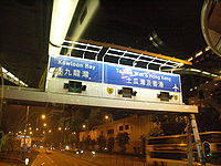
Hong Kong
Hong Kong is one of two Special Administrative Regions of the People's Republic of China , the other being Macau. A city-state situated on China's south coast and enclosed by the Pearl River Delta and South China Sea, it is renowned for its expansive skyline and deep natural harbour...
routes in 2004, in conjunction with the re-organization of the route numbers. A sequential numbering scheme is used.
Japan
The main expressway system uses sequential numbering; Metropolitan Expressway systems also use sequential junction numbering, usually appended with the expressway number expressed this way: 5-1; 5-2, etc. There are multiple toll expressways not operated by the major national syndicates or the Metropolitan Expressway Authorities that have no junction numbering scheme.Malaysia
Johor Bahru
Johor Bahru is the capital city of Johor in southern Malaysia. Johor Bahru is the southernmost city of the Eurasian mainland...
exit at the end of North-South Expressway is labelled , where the last two digits (57) are the assigned exit number and the first digit (2) is the expressway route number (E2). Meanwhile, Jalan Templer
Jalan Templer
Jalan Templer is a major road in Petaling Jaya city, Selangor, Malaysia. It was the first road built in Petaling Jaya and was simply called "Jalan 1" or Road 1...
exit at the Federal Highway
Federal Highway, Malaysia
Federal Highway, or Lebuhraya Persekutuan in Malay is a Malaysian highway connecting the capital city of Kuala Lumpur, and Klang, Selangor. The highway starts from Seputeh in Kuala Lumpur to Klang, Selangor...
is labelled , where the two digits (24) are the assigned exit number and the first digit (2) is the federal route number (2).
The exit numbers may either be arranged sequential or be skipped by a few numbers between two interchanges to allow the addition of future interchanges in between. For example, Bangi and Nilai North interchanges of the North-South Expressway are numbered as and respectively, allowing the newer Putra Mahkota Interchange to be assigned as . In case if a new interchange is constructed between two older interchanges with their exit numbers being assigned sequentially, the new interchange's exit number will be the same as the previous interchange with the addition of a letter. For example, the newer Sungai Balak Interchange on the Cheras–Kajang Expressway, which is located between the older Bukit Dukung Interchange and Saujana Impian Interchange, is assigned as .
New Zealand
New Zealand began introducing exit numbers in 2005. It uses a distance-based numbering system. The distance to the exit is measured from the origin of the highway. That is:- State Highway 1 (Northern & Southern motorways) measured from the origin of SH1 at Cape ReingaCape ReingaCape Reinga is the northwesternmost tip of the Aupouri Peninsula, at the northern end of the North Island of New Zealand. Cape Reinga is located over 100 km north of the nearest small town of Kaitaia. State Highway 1 extends all the way to the Cape, but until 2010 was unsealed gravel road for the...
- State Highway 16 (Northwestern Motorway) measured from the origin at the Port
- State Highway 20 (Southwestern Motorway) measured from the origin at SH1
There is no exit zero. If there is an exit within 1.499 km of the origin, Exit 1 is used. Exit 2 would be between 1.500 and 2.499 km of the origin. Subsequent 'exit zones' are at 1 km intervals.
Letter suffixes are added at multi-exit interchanges, or where two or more exits exist within the same exit zone. For example, State Highway 1 (Southern Motorway) has an Exit 429A (Symonds St), Exit 429B (Wellesley St) and Exit 429C (Port).
Instead of replacing existing ramp and link signs, the exit numbers were added as supplementary information. Thus drivers can navigate either by exit number or name.
Exit numbers are only used for exits that may be used by all vehicle types. Bus- or emergency vehicle-only exits would not be numbered.
Exit signage and text is identical in appearance to American freeway signs.
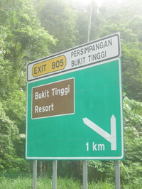
The Philippines
Metric distance based numbers are used on the tollways radiating from Manila. Supplemental "A" and "B" designations are appended to signage at the ends of slip roads. Freeway signage, exit tabs, and kilometer-posts are nearly identical in appearance to American freeway signage.South Africa
Uses distance based numbering (in kilometers) on main motorways. Letter suffixes are added at multi-exit interchanges, an example being the Buccleuch interchange in JohannesburgJohannesburg
Johannesburg also known as Jozi, Jo'burg or Egoli, is the largest city in South Africa, by population. Johannesburg is the provincial capital of Gauteng, the wealthiest province in South Africa, having the largest economy of any metropolitan region in Sub-Saharan Africa...
. Exit numbers are reset on the pre-1995 provincial borders, thus exit numbering can change in the middle of a post-1995 province. One exception to the usual distance based numbering is the southern portion of the M4 in Durban
Durban
Durban is the largest city in the South African province of KwaZulu-Natal and the third largest city in South Africa. It forms part of the eThekwini metropolitan municipality. Durban is famous for being the busiest port in South Africa. It is also seen as one of the major centres of tourism...
, which uses sequential numbering.
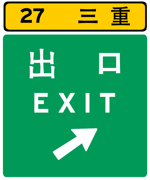
Taiwan
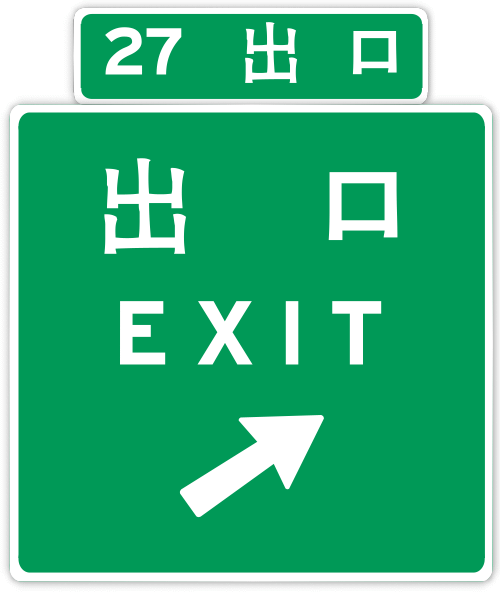
Taiwan
Taiwan , also known, especially in the past, as Formosa , is the largest island of the same-named island group of East Asia in the western Pacific Ocean and located off the southeastern coast of mainland China. The island forms over 99% of the current territory of the Republic of China following...
uses distance-based exit numbers in kilometers. If two exits are located within the same kilometer mark, the Roman letters are appended to differentiate the exits. Taiwan did experiment with sequential exit numbers with National Freeway No. 1 for a couple of years, but abandoned the experiment in 2004.
Prior to 2006, Taiwan exit signs were generally near replicas of their US counterparts. However, the exit signs now not only indicate the distance number, but they also display the Chinese code-name for the interchange.
United States
The use of sequential or distance-based exit numbering currently varies by state, with 43 states using distance-based exit numbering and seven states using sequential numbering. The latest edition of the Manual on Uniform Traffic Control DevicesManual on Uniform Traffic Control Devices
The Manual on Uniform Traffic Control Devices is a document issued by the Federal Highway Administration of the United States Department of Transportation to specify the standards by which traffic signs, road surface markings, and signals are designed, installed, and used...
(MUTCD), issued by the Federal Highway Administration on December 16, 2009, eliminates the option for states to use sequential exit numbering, and requires the seven states that presently number their exits sequentially to convert to distance-based numbering by January 2020. Citing the cost for conversion and the potential inconvenience to motorists and businesses, most of the states that still use sequential-based exit numbering are applying for waivers from the Federal Highway Administration (FHWA) that would allow them to retain their respective exit numbering systems beyond the 2020 mandatory conversion date.