
.gif)
Interstate 84 (west)
Encyclopedia
Interstate 84 is an Interstate Highway in the Western United States
that runs from Portland
, Oregon
, to a junction with Interstate 80
near Echo
, Utah
. The highway originally served as a fork of I-80 to serve the Pacific Northwest
, and was originally numbered Interstate 80N.
The highway serves and connects Portland, Oregon and Boise
, Idaho
with Ogden
, Utah. Seattle
, Washington is indirectly served by I-84 via a connection with Interstate 82
. With the connection to I-80, I-84 connects these cities to points east.
I-80N was generally built along the corridor of U.S. Route 30
and U.S. Route 30S
; the U.S. Route 30S designation was decommissioned in the 1970s after the freeway replacement was mostly complete. The highway was signed with the I-84 designation in 1980, when a 1977 change in guidelines took effect that discouraged highway numbers with directional suffixes. The renumbering resulted in two highways being numbered I-84, with the other
residing in the Northeastern United States
.
|OR
|375.17
|603.78
|-
|ID
|275.74
|443.76
|-
|UT
|118.71
|191.05
|-
|Total
|769.62
|1238.58
|}
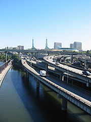
In the Portland metropolitan area
, I-84 is sometimes referred to as the "Banfield Freeway" or simply "the Banfield", although the official name is the Banfield Expressway. This freeway is named after Thomas H. Banfield, the chairman of the Oregon Transportation Commission from 1943 to 1950.
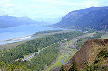
East of Pendleton
, I-84 climbs Emigrant Hill
, a 6% grade, into the Blue Mountains
. This grade is known for the fact that the westbound lanes switchback twice on its descent into Pendleton. Eastbound lanes feature what are the tightest curves allowed on the Interstate Highway system, even though those curves are on the uphill (eastbound) direction. This grade is also well known due to the fact that it features such a great distance between eastbound and westbound lanes, nearly 2 miles (3.2 km) between the opposite directions of travel at some points. The road summits at 4193 feet (1278 m) above sea level before descending to the Grand Ronde River and La Grande
. It passes by North Powder
and Baker City
and through the Burnt River
canyon. Around Huntington
, it crosses into the Mountain Time Zone
then briefly follows the Snake River (Brownlee Reservoir
), then continues to Ontario to cross the Snake River into Idaho.
at Ontario, Oregon
. From there, it continues on to the major cities of the Treasure Valley
, or Boise metropolitan area
, including Caldwell
, Nampa
, Meridian
, and Boise
(where I-184
connects travelers to downtown). From Boise, I-84 continues southeast towards Twin Falls
, after passing near several small cities (Mountain Home
, Glenns Ferry
, and Jerome
).
Just east of Jerome, I-84 passes within 5 miles (8 km) of Twin Falls, but does not cross the Snake River Canyon
or into Twin Falls County
. Access to Twin Falls is afforded by an intersection with US 93
at Exit 173; US 93 southbound crosses the Snake River via the Perrine Bridge
.
After Twin Falls, I-84 continues through Burley
and Heyburn
. Approximately 7 miles (11 km) east of Declo
in rural Cassia County
, I-84 meets I-86. I-84 heads southeast towards Utah and I-86
heads east, then northeast to American Falls
and Pocatello
, following the Oregon Trail
.
in Box Elder County
. It proceeds southeast towards Tremonton
where I-84 joins I-15
.
Just south, at Corinne, Utah
, I-84 joins the route of the First Transcontinental Railroad
which the highway follows to its terminus. I-15/I-84 pass to the west of Ogden
where I-84 separates from I-15 and follows the Weber River
. As the freeway passes through Weber Canyon
it also passes through several small farming communities, including Morgan
, where the Browning Arms Company
headquarters can be seen from the freeway. Also visible in the canyon is Devil's Slide
, an unusual rock formation just off the freeway. Farther up the canyon is the Thousand Mile Tree
, planted by Union Pacific Railroad
workers to mark 1000 miles (1,609.3 km) from the railroad's origin in Omaha, Nebraska
. The freeway ends at Echo
, a near ghost town that before served as a stopover for the railroad, at a junction with Interstate 80
. Also near the junction is Echo Reservoir and Echo Dam.
The Utah sections of I-84 not concurrent with Interstate 15
are defined at Utah Code Annotated § 72-4-114(4).
 American Association of State Highway and Transportation Officials
established guidelines recommending that "suffixed" highways, such as I-80N, be renumbered. In 1977, Idaho officials recommended that I-80N be renumbered to I-84. The motion was seconded by officials in Utah, but opposed by Oregon and Washington. The motion passed on July 7, 1977, and the states were given until July 1, 1980 to implement a co-ordinated renumbering strategy.
After renumbering, I-84 violated the Interstate Highway Numbering Convention by being south of I-82. The Portland segment of then-I-80N was proposed to run on the Mount Hood Freeway. Plans for this were officially dropped in 1978 after a successful freeway revolt.
Western United States
.The Western United States, commonly referred to as the American West or simply "the West," traditionally refers to the region comprising the westernmost states of the United States. Because the U.S. expanded westward after its founding, the meaning of the West has evolved over time...
that runs from Portland
Portland, Oregon
Portland is a city located in the Pacific Northwest, near the confluence of the Willamette and Columbia rivers in the U.S. state of Oregon. As of the 2010 Census, it had a population of 583,776, making it the 29th most populous city in the United States...
, Oregon
Oregon
Oregon is a state in the Pacific Northwest region of the United States. It is located on the Pacific coast, with Washington to the north, California to the south, Nevada on the southeast and Idaho to the east. The Columbia and Snake rivers delineate much of Oregon's northern and eastern...
, to a junction with Interstate 80
Interstate 80
Interstate 80 is the second-longest Interstate Highway in the United States, following Interstate 90. It is a transcontinental artery running from downtown San Francisco, California to Teaneck, New Jersey in the New York City Metropolitan Area...
near Echo
Echo, Utah
Echo is a census-designated place located in Summit County, Utah, United States. The population was 56 at the 2010 census. Although Echo has never had a sizable population, the town is historically significant.-History:...
, Utah
Utah
Utah is a state in the Western United States. It was the 45th state to join the Union, on January 4, 1896. Approximately 80% of Utah's 2,763,885 people live along the Wasatch Front, centering on Salt Lake City. This leaves vast expanses of the state nearly uninhabited, making the population the...
. The highway originally served as a fork of I-80 to serve the Pacific Northwest
Pacific Northwest
The Pacific Northwest is a region in northwestern North America, bounded by the Pacific Ocean to the west and, loosely, by the Rocky Mountains on the east. Definitions of the region vary and there is no commonly agreed upon boundary, even among Pacific Northwesterners. A common concept of the...
, and was originally numbered Interstate 80N.
The highway serves and connects Portland, Oregon and Boise
Boise, Idaho
Boise is the capital and most populous city of the U.S. state of Idaho, as well as the county seat of Ada County. Located on the Boise River, it anchors the Boise City-Nampa metropolitan area and is the largest city between Salt Lake City, Utah and Portland, Oregon.As of the 2010 Census Bureau,...
, Idaho
Idaho
Idaho is a state in the Rocky Mountain area of the United States. The state's largest city and capital is Boise. Residents are called "Idahoans". Idaho was admitted to the Union on July 3, 1890, as the 43rd state....
with Ogden
Ogden, Utah
Ogden is a city in Weber County, Utah, United States. Ogden serves as the county seat of Weber County. The population was 82,825 according to the 2010 Census. The city served as a major railway hub through much of its history, and still handles a great deal of freight rail traffic which makes it a...
, Utah. Seattle
Seattle, Washington
Seattle is the county seat of King County, Washington. With 608,660 residents as of the 2010 Census, Seattle is the largest city in the Northwestern United States. The Seattle metropolitan area of about 3.4 million inhabitants is the 15th largest metropolitan area in the country...
, Washington is indirectly served by I-84 via a connection with Interstate 82
Interstate 82
Interstate 82 is a Interstate Highway that extends from I-90 in Ellensburg, Washington to I-84 near Umatilla, Oregon in the United States. In the state of Washington, it serves the cities of Ellensburg, Yakima, and the Tri Cities , and in Oregon, it serves Umatilla and Hermiston...
. With the connection to I-80, I-84 connects these cities to points east.
I-80N was generally built along the corridor of U.S. Route 30
U.S. Route 30
U.S. Route 30 is an east–west main route of the system of United States Numbered Highways, with the highway traveling across the northern tier of the country. It is the third longest U.S. route, after U.S. Route 20 and U.S. Route 6. The western end of the highway is at Astoria, Oregon; the...
and U.S. Route 30S
U.S. Route 30S
U.S. Route 30S may refer to:*U.S. Route 30S , now OR 201 and US 20/US 26 from Ontario to the Idaho state line*U.S. Route 30S , now I-84 and I-80 from Burley to Granger...
; the U.S. Route 30S designation was decommissioned in the 1970s after the freeway replacement was mostly complete. The highway was signed with the I-84 designation in 1980, when a 1977 change in guidelines took effect that discouraged highway numbers with directional suffixes. The renumbering resulted in two highways being numbered I-84, with the other
Interstate 84 (east)
Interstate 84 is an Interstate Highway extending from Dunmore, Pennsylvania at an interchange with Interstate 81 to Sturbridge, Massachusetts, at an interchange with the Massachusetts Turnpike . I-84 has mile-log junction numbering in Pennsylvania; otherwise, exit numbers are roughly sequential...
residing in the Northeastern United States
Northeastern United States
The Northeastern United States is a region of the United States as defined by the United States Census Bureau.-Composition:The region comprises nine states: the New England states of Connecticut, Maine, Massachusetts, New Hampshire, Rhode Island and Vermont; and the Mid-Atlantic states of New...
.
Route description
|-|OR
Interstate 84 in Oregon
In the U.S. state of Oregon, Interstate 84 travels east–west, following the Columbia River and the rough path of the old Oregon Trail from Portland east to Idaho. For this reason, it is also known as most of the Columbia River Highway No. 2 and all of the Old Oregon Trail Highway No. 6 . It...
|375.17
|603.78
|-
|ID
Interstate 84 in Idaho
In the U.S. state of Idaho, Interstate 84 heads southeast from the Oregon state line, it spurs to Interstate 184 in Boise. Eventually I-84 spurs Interstate 86 and mainline I-84 heads southeast towards Utah and I-86 is continues due east and heads to Pocatello, meeting with Interstate 15.-Future:...
|275.74
|443.76
|-
|UT
Interstate 84 in Utah
In the U.S. state of Utah, Interstate 84 heads southeast from the Idaho state line, overlapping Interstate 15 between Tremonton and Ogden and ending at Interstate 80 at Echo.-Western segment:...
|118.71
|191.05
|-
|Total
|769.62
|1238.58
|}
Oregon
In the Portland metropolitan area
Portland metropolitan area
The Portland-Vancouver-Hillsboro, OR-WA Metropolitan Statistical Area , also known as the Portland metropolitan area or Greater Portland, is an urban area in the U.S. states of Oregon and Washington centered around the city of Portland, Oregon. The U.S...
, I-84 is sometimes referred to as the "Banfield Freeway" or simply "the Banfield", although the official name is the Banfield Expressway. This freeway is named after Thomas H. Banfield, the chairman of the Oregon Transportation Commission from 1943 to 1950.
East of Pendleton
Pendleton, Oregon
Pendleton is a city in Umatilla County, Oregon, United States. Pendleton was named in 1868 by the county commissioners for George H. Pendleton, Democratic candidate for Vice-President in the 1864 presidential campaign. The population was 16,612 at the 2010 census...
, I-84 climbs Emigrant Hill
Blue Mountains (Oregon)
The Blue Mountains are a mountain range in the western United States, located largely in northeastern Oregon and stretching into southeastern Washington...
, a 6% grade, into the Blue Mountains
Blue Mountains (Oregon)
The Blue Mountains are a mountain range in the western United States, located largely in northeastern Oregon and stretching into southeastern Washington...
. This grade is known for the fact that the westbound lanes switchback twice on its descent into Pendleton. Eastbound lanes feature what are the tightest curves allowed on the Interstate Highway system, even though those curves are on the uphill (eastbound) direction. This grade is also well known due to the fact that it features such a great distance between eastbound and westbound lanes, nearly 2 miles (3.2 km) between the opposite directions of travel at some points. The road summits at 4193 feet (1278 m) above sea level before descending to the Grand Ronde River and La Grande
La Grande, Oregon
-Demographics:As of the census of 2000, there were 12,327 people, 5,124 households, and 2,982 families residing in the city. The population density was 2,833.5 people per square mile . There were 5,483 housing units at an average density of 1,260.3 per square mile...
. It passes by North Powder
North Powder, Oregon
North Powder is a city in Union County, Oregon, United States. The population was 489 at the 2000 census.-History:North Powder was platted in 1885 or 1886 along the Oregon Railway and Navigation Company rail line, having been a stage stop before then....
and Baker City
Baker City, Oregon
Baker City is a city in and the county seat of Baker County, Oregon, United States. It was named after Edward D. Baker. The population was 9,828 at the 2010 census.-History:...
and through the Burnt River
Burnt River
Burnt River may refer to:*the Burnt River in Ontario, Canada*the community of Burnt River, Ontario*Burnt River , tributary of the Snake River in eastern Oregon, US...
canyon. Around Huntington
Huntington, Oregon
Huntington is a city in Baker County, on the eastern border of Oregon, United States. It is located on the Snake River and along Interstate 84 and U.S. Route 30. The population was 515 at the 2000 census.- History:...
, it crosses into the Mountain Time Zone
Mountain Time Zone
The Mountain Time Zone of North America keeps time by subtracting seven hours from Coordinated Universal Time, also known as Greenwich Mean Time, during the shortest days of autumn and winter , and by subtracting six hours during daylight saving time in the spring, summer, and early autumn...
then briefly follows the Snake River (Brownlee Reservoir
Brownlee Dam
Brownlee Dam is a hydroelectric earth fill embankment dam on the Snake River on the Idaho-Oregon border, in Hells Canyon . It impounds the Snake River in the long Brownlee Reservoir...
), then continues to Ontario to cross the Snake River into Idaho.
Idaho
I-84 enters Idaho by crossing the Snake RiverSnake River
The Snake is a major river of the greater Pacific Northwest in the United States. At long, it is the largest tributary of the Columbia River, the largest North American river that empties into the Pacific Ocean...
at Ontario, Oregon
Ontario, Oregon
Ontario is the largest city in Malheur County, Oregon, United States. It lies along the Snake River at the Idaho border. The population was 10,985 at the 2000 census, with an estimated population of 11,245 in 2006...
. From there, it continues on to the major cities of the Treasure Valley
Treasure Valley
The Treasure Valley is the area of the Western United States where the Payette, Boise, Weiser, Malheur, Owyhee, and Burnt rivers drain into the Snake River. Treasure Valley includes all the lowland areas from Vale, Oregon on the west to Boise, Idaho on the east. Formerly, the valley had been known...
, or Boise metropolitan area
Boise metropolitan area
The Boise City-Nampa, Idaho Metropolitan Statistical Area , as defined by the United States Census Bureau, is an area consisting of five counties in southwestern Idaho, anchored by the cities of Boise and Nampa...
, including Caldwell
Caldwell, Idaho
Caldwell is a city in and the county seat of Canyon County, Idaho, United States. The U.S. Census Bureau estimated the population to be 43,281, as of July 2009.Caldwell is the home of the College of Idaho. It is considered part of the Boise metropolitan area....
, Nampa
Nampa, Idaho
Nampa is the largest and the fastest growing city in Canyon County, Idaho, USA. The population of Nampa was 81,557 at the 2010 census. Nampa is located about west of Boise along Interstate 84, and six miles west of Meridian. Nampa is part of the Boise metropolitan area...
, Meridian
Meridian, Idaho
-History:The town was established in 1891 on the Onweiler farm north of the present site and was called Hunter. Two years later an I.O.O.F. lodge was organized and called itself Meridian because it was located on the Boise Meridian and the town was renamed...
, and Boise
Boise, Idaho
Boise is the capital and most populous city of the U.S. state of Idaho, as well as the county seat of Ada County. Located on the Boise River, it anchors the Boise City-Nampa metropolitan area and is the largest city between Salt Lake City, Utah and Portland, Oregon.As of the 2010 Census Bureau,...
(where I-184
Interstate 184
Interstate 184 is a short Interstate Highway spur route of Interstate 84 located in Idaho. I-184 connects I-84 travelers to downtown Boise. The western terminus of I-184 is with I-84; the eastern terminus 13th Street in downtown Boise, where I-184 empties eastbound traffic onto Myrtle Street and...
connects travelers to downtown). From Boise, I-84 continues southeast towards Twin Falls
Twin Falls, Idaho
Twin Falls is the county seat and largest city of Twin Falls County, Idaho, United States. The population was 44,125 at the 2010 censusTwin Falls is the largest city of Idaho's Magic Valley region...
, after passing near several small cities (Mountain Home
Mountain Home, Idaho
Mountain Home is the largest city and county seat of Elmore County, Idaho. The population was 14,206 at the 2010 census. Mountain Home is the principal city of the Mountain Home, ID Micropolitan Statistical Area, which includes Elmore County....
, Glenns Ferry
Glenns Ferry, Idaho
Glenns Ferry is a city in Elmore County, Idaho, United States. The population was 1,611 at the 2000 census. The city is adjacent to Interstate 84 and the Snake River.-History:Glenns Ferry was one of the most famous river crossings on the Oregon Trail...
, and Jerome
Jerome, Idaho
Jerome is a city in Jerome County, Idaho, U.S.A. The population was 10,890 at the 2010 census. The city is the county seat of Jerome County, and sits at an elevation of 3763 feet above sea level. It is part of the Twin Falls, Idaho Micropolitan Statistical Area.-Geography:Jerome is located at ...
).
Just east of Jerome, I-84 passes within 5 miles (8 km) of Twin Falls, but does not cross the Snake River Canyon
Snake River Canyon (Idaho)
Snake River Canyon is a large canyon formed by the Snake River in the Magic Valley region of southern Idaho. It is well known as the site of an unsuccessful 1974 attempt by Evel Knievel to jump it in the Skycycle X-2....
or into Twin Falls County
Twin Falls County, Idaho
Twin Falls County is a county in the south central part of the U.S. state of Idaho. As of the 2000 Census, the county had a population of 64,284 . The county seat and largest city is Twin Falls....
. Access to Twin Falls is afforded by an intersection with US 93
U.S. Route 93
U.S. Route 93 is a major north–south United States highway in the western United States. The southern terminus is at U.S. Route 60 in Wickenburg, Arizona. The northern terminus is at the Canadian border north of Eureka in Lincoln County, Montana, where the roadway continues into Roosville,...
at Exit 173; US 93 southbound crosses the Snake River via the Perrine Bridge
Perrine Bridge
The I. B. Perrine Bridge at Twin Falls, Idaho, United States is a truss arch four-lane bridge carrying U.S. Highway 93 over the Snake River Canyon. Perrine Bridge is approximately long and above the Snake River...
.
After Twin Falls, I-84 continues through Burley
Burley, Idaho
Burley is a city in Cassia and Minidoka counties in the southern portion of the U.S. state of Idaho. The population was 10,345 at the 2010 census. The city is the county seat of Cassia County....
and Heyburn
Heyburn, Idaho
Heyburn is a city in Minidoka County, Idaho, United States. The population was 2,899 at the 2000 census. It is part of the Burley, Idaho Micropolitan Statistical Area.The city was named after Weldon Heyburn, a U.S. Senator from Idaho from 1903-12....
. Approximately 7 miles (11 km) east of Declo
Declo, Idaho
Declo is a city in Cassia County, Idaho, United States. It is part of the Burley, Idaho Micropolitan Statistical Area. The population was 343 at the 2010 census. The world's largest potato processing company was founded in 1923 near Declo by a 14-year-old entrepreneur named J.R. Simplot. The...
in rural Cassia County
Cassia County, Idaho
Cassia County is a county located in the U.S. state of Idaho. As of the 2010 Census the county had a population of 22,952. The county seat and largest city is Burley.-History:...
, I-84 meets I-86. I-84 heads southeast towards Utah and I-86
Interstate 86 (west)
Interstate 86 is an intrastate Interstate Highway, located entirely within the state of Idaho. It runs 63 miles from an intersection with Interstate 84 located approximately 7 miles east of Declo in rural Cassia County, to an intersection with Interstate 15 at Pocatello...
heads east, then northeast to American Falls
American Falls, Idaho
American Falls is a city in and the county seat of Power County, Idaho, United States. The population was 4,111 at the 2000 census. It is part of the Pocatello, Idaho Metropolitan Statistical Area.-History:...
and Pocatello
Pocatello, Idaho
Pocatello is the county seat and largest city of Bannock County, with a small portion on the Fort Hall Indian Reservation in neighboring Power County, in the southeastern part of the U.S. state of Idaho. It is the principal city of the Pocatello metropolitan area, which encompasses all of Bannock...
, following the Oregon Trail
Oregon Trail
The Oregon Trail is a historic east-west wagon route that connected the Missouri River to valleys in Oregon and locations in between.After 1840 steam-powered riverboats and steamboats traversing up and down the Ohio, Mississippi and Missouri rivers sped settlement and development in the flat...
.
Utah
From Idaho, I-84 enters Utah at a point approximately 7 miles (11.3 km) from SnowvilleSnowville, Utah
Snowville is a town in Box Elder County, Utah, United States. The population was 167 at the 2010 census.-Geography:Snowville is located at , at in elevation....
in Box Elder County
Box Elder County, Utah
Box Elder County is a county located in the U.S. state of Utah. It lies on the north end of the Great Salt Lake, covering a large area north to the Idaho border and west to the Nevada border. Included in this area are large tracts of barren desert, contrasted by high, forested mountains. The...
. It proceeds southeast towards Tremonton
Tremonton, Utah
Tremonton is a city in Box Elder County, Utah, United States. The population was 7,647 at the 2010 census.-Geography:Tremonton is located at ....
where I-84 joins I-15
Interstate 15 in Utah
In the U.S. state of Utah, Interstate 15 runs north–south through the southwestern and central portions of the state, passing through many of the population centers of that state, including St. George, Provo, Salt Lake City, and Ogden, the latter three being part of the urban area known as...
.
Just south, at Corinne, Utah
Corinne, Utah
Corinne is a city in Box Elder County, Utah, United States. The population was 685 at the 2010 census.-Geography:Corinne is located at ....
, I-84 joins the route of the First Transcontinental Railroad
First Transcontinental Railroad
The First Transcontinental Railroad was a railroad line built in the United States of America between 1863 and 1869 by the Central Pacific Railroad of California and the Union Pacific Railroad that connected its statutory Eastern terminus at Council Bluffs, Iowa/Omaha, Nebraska The First...
which the highway follows to its terminus. I-15/I-84 pass to the west of Ogden
Ogden, Utah
Ogden is a city in Weber County, Utah, United States. Ogden serves as the county seat of Weber County. The population was 82,825 according to the 2010 Census. The city served as a major railway hub through much of its history, and still handles a great deal of freight rail traffic which makes it a...
where I-84 separates from I-15 and follows the Weber River
Weber River
The Weber River is a c. long river of northern Utah, USA. It begins in the northwest of the Uinta Mountains and empties into the Great Salt Lake. The Weber River was named for American fur trapper John Henry Weber.-Weber River:...
. As the freeway passes through Weber Canyon
Weber Canyon
Weber Canyon is a canyon in the Wasatch Range near Ogden, Utah, through which the Weber River flows west toward the Great Salt Lake. It is fed by 13 tributary creeks and is 40 miles long.- History :...
it also passes through several small farming communities, including Morgan
Morgan, Utah
Morgan is a city in Morgan County, Utah, in the United States. It is part of the Ogden–Clearfield, Utah Metropolitan Statistical Area. It is named after Jedediah Morgan Grant, a leader in The Church of Jesus Christ of Latter-day Saints. As of the 2010 census, the city population was 3,687....
, where the Browning Arms Company
Browning Arms Company
Browning Arms Company is a maker of firearms, bows and fishing gear. Founded in Utah in 1927, it offers a wide variety of firearms, including shotguns, rifles, pistols, and rimfire firearms and sport bows, as well as fishing rods and reels....
headquarters can be seen from the freeway. Also visible in the canyon is Devil's Slide
Devil's Slide (Utah)
Devil's Slide is an unusual geological formation located in northern Utah's Weber Canyon, near the community of Croydon in Morgan County, Utah, United States. The slide consists of two parallel limestone strata that have been tilted to lie vertical, protruding out of the mountainside...
, an unusual rock formation just off the freeway. Farther up the canyon is the Thousand Mile Tree
Thousand Mile Tree
Thousand Mile Tree is a pine tree located in Weber Canyon near the community of Henefer, Utah, along the Overland Route of the Union Pacific Railroad...
, planted by Union Pacific Railroad
Union Pacific Railroad
The Union Pacific Railroad , headquartered in Omaha, Nebraska, is the largest railroad network in the United States. James R. Young is president, CEO and Chairman....
workers to mark 1000 miles (1,609.3 km) from the railroad's origin in Omaha, Nebraska
Omaha, Nebraska
Omaha is the largest city in the state of Nebraska, United States, and is the county seat of Douglas County. It is located in the Midwestern United States on the Missouri River, about 20 miles north of the mouth of the Platte River...
. The freeway ends at Echo
Echo, Utah
Echo is a census-designated place located in Summit County, Utah, United States. The population was 56 at the 2010 census. Although Echo has never had a sizable population, the town is historically significant.-History:...
, a near ghost town that before served as a stopover for the railroad, at a junction with Interstate 80
Interstate 80
Interstate 80 is the second-longest Interstate Highway in the United States, following Interstate 90. It is a transcontinental artery running from downtown San Francisco, California to Teaneck, New Jersey in the New York City Metropolitan Area...
. Also near the junction is Echo Reservoir and Echo Dam.
The Utah sections of I-84 not concurrent with Interstate 15
Interstate 15 in Utah
In the U.S. state of Utah, Interstate 15 runs north–south through the southwestern and central portions of the state, passing through many of the population centers of that state, including St. George, Provo, Salt Lake City, and Ogden, the latter three being part of the urban area known as...
are defined at Utah Code Annotated § 72-4-114(4).
History
American Association of State Highway and Transportation Officials
AASHTO, the American Association of State Highway and Transportation Officials, is a standards setting body which publishes specifications, test protocols and guidelines which are used in highway design and construction throughout the United States...
established guidelines recommending that "suffixed" highways, such as I-80N, be renumbered. In 1977, Idaho officials recommended that I-80N be renumbered to I-84. The motion was seconded by officials in Utah, but opposed by Oregon and Washington. The motion passed on July 7, 1977, and the states were given until July 1, 1980 to implement a co-ordinated renumbering strategy.
After renumbering, I-84 violated the Interstate Highway Numbering Convention by being south of I-82. The Portland segment of then-I-80N was proposed to run on the Mount Hood Freeway. Plans for this were officially dropped in 1978 after a successful freeway revolt.
Major intersections
.svg.png) Interstate 5Interstate 5Interstate 5 is the main Interstate Highway on the West Coast of the United States, running largely parallel to the Pacific Ocean coastline from Canada to Mexico . It serves some of the largest cities on the U.S...
Interstate 5Interstate 5Interstate 5 is the main Interstate Highway on the West Coast of the United States, running largely parallel to the Pacific Ocean coastline from Canada to Mexico . It serves some of the largest cities on the U.S...
in Portland, OregonPortland, OregonPortland is a city located in the Pacific Northwest, near the confluence of the Willamette and Columbia rivers in the U.S. state of Oregon. As of the 2010 Census, it had a population of 583,776, making it the 29th most populous city in the United States....svg.png) Interstate 205Interstate 205 (Oregon-Washington)Interstate 205 is a loop route that serves the Portland—Vancouver metropolitan area in the U.S. states of Oregon and Washington. I-205 is officially named the War Veterans Memorial Freeway, and is also known as the East Portland Freeway...
Interstate 205Interstate 205 (Oregon-Washington)Interstate 205 is a loop route that serves the Portland—Vancouver metropolitan area in the U.S. states of Oregon and Washington. I-205 is officially named the War Veterans Memorial Freeway, and is also known as the East Portland Freeway...
in Portland, OregonPortland, OregonPortland is a city located in the Pacific Northwest, near the confluence of the Willamette and Columbia rivers in the U.S. state of Oregon. As of the 2010 Census, it had a population of 583,776, making it the 29th most populous city in the United States....svg.png) Interstate 82Interstate 82Interstate 82 is a Interstate Highway that extends from I-90 in Ellensburg, Washington to I-84 near Umatilla, Oregon in the United States. In the state of Washington, it serves the cities of Ellensburg, Yakima, and the Tri Cities , and in Oregon, it serves Umatilla and Hermiston...
Interstate 82Interstate 82Interstate 82 is a Interstate Highway that extends from I-90 in Ellensburg, Washington to I-84 near Umatilla, Oregon in the United States. In the state of Washington, it serves the cities of Ellensburg, Yakima, and the Tri Cities , and in Oregon, it serves Umatilla and Hermiston...
in Hermiston, OregonHermiston, OregonAs of the census of 2010, there were 16,745 people, 4,964 households, and 3,360 families residing in the city. The population density was 2,035.4 people per square mile . There were 5,383 housing units at an average density of 832.9 per square mile....svg.png) Interstate 184Interstate 184Interstate 184 is a short Interstate Highway spur route of Interstate 84 located in Idaho. I-184 connects I-84 travelers to downtown Boise. The western terminus of I-184 is with I-84; the eastern terminus 13th Street in downtown Boise, where I-184 empties eastbound traffic onto Myrtle Street and...
Interstate 184Interstate 184Interstate 184 is a short Interstate Highway spur route of Interstate 84 located in Idaho. I-184 connects I-84 travelers to downtown Boise. The western terminus of I-184 is with I-84; the eastern terminus 13th Street in downtown Boise, where I-184 empties eastbound traffic onto Myrtle Street and...
in Boise, IdahoBoise, IdahoBoise is the capital and most populous city of the U.S. state of Idaho, as well as the county seat of Ada County. Located on the Boise River, it anchors the Boise City-Nampa metropolitan area and is the largest city between Salt Lake City, Utah and Portland, Oregon.As of the 2010 Census Bureau,....svg.png) Interstate 86Interstate 86 (west)Interstate 86 is an intrastate Interstate Highway, located entirely within the state of Idaho. It runs 63 miles from an intersection with Interstate 84 located approximately 7 miles east of Declo in rural Cassia County, to an intersection with Interstate 15 at Pocatello...
Interstate 86Interstate 86 (west)Interstate 86 is an intrastate Interstate Highway, located entirely within the state of Idaho. It runs 63 miles from an intersection with Interstate 84 located approximately 7 miles east of Declo in rural Cassia County, to an intersection with Interstate 15 at Pocatello...
in Heyburn, IdahoHeyburn, IdahoHeyburn is a city in Minidoka County, Idaho, United States. The population was 2,899 at the 2000 census. It is part of the Burley, Idaho Micropolitan Statistical Area.The city was named after Weldon Heyburn, a U.S. Senator from Idaho from 1903-12.....svg.png) Interstate 15Interstate 15 in UtahIn the U.S. state of Utah, Interstate 15 runs north–south through the southwestern and central portions of the state, passing through many of the population centers of that state, including St. George, Provo, Salt Lake City, and Ogden, the latter three being part of the urban area known as...
Interstate 15Interstate 15 in UtahIn the U.S. state of Utah, Interstate 15 runs north–south through the southwestern and central portions of the state, passing through many of the population centers of that state, including St. George, Provo, Salt Lake City, and Ogden, the latter three being part of the urban area known as...
from Tremonton, UtahTremonton, UtahTremonton is a city in Box Elder County, Utah, United States. The population was 7,647 at the 2010 census.-Geography:Tremonton is located at ....
to Ogden, UtahOgden, UtahOgden is a city in Weber County, Utah, United States. Ogden serves as the county seat of Weber County. The population was 82,825 according to the 2010 Census. The city served as a major railway hub through much of its history, and still handles a great deal of freight rail traffic which makes it a...
..svg.png) Interstate 80Interstate 80Interstate 80 is the second-longest Interstate Highway in the United States, following Interstate 90. It is a transcontinental artery running from downtown San Francisco, California to Teaneck, New Jersey in the New York City Metropolitan Area...
Interstate 80Interstate 80Interstate 80 is the second-longest Interstate Highway in the United States, following Interstate 90. It is a transcontinental artery running from downtown San Francisco, California to Teaneck, New Jersey in the New York City Metropolitan Area...
in Echo, UtahEcho, UtahEcho is a census-designated place located in Summit County, Utah, United States. The population was 56 at the 2010 census. Although Echo has never had a sizable population, the town is historically significant.-History:...