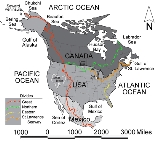
The
Continental Divide of the Americas, or merely the
Continental Gulf of Division or
Great Divide, is the name given to the principal, and largely
mountainImage:Himalaya_annotated.jpg|thumb|right|The Himalayan mountain range with Mount Everestrect 58 14 160 49 Chomo Lonzorect 200 28 335 52 Makalurect 378 24 566 45 Mount Everestrect 188 581 920 656 Tibetan Plateaurect 250 406 340 427 Rong River...
ous, hydrological divide of the
AmericasThe Americas, or America , are lands in the Western hemisphere, also known as the New World. In English, the plural form the Americas is often used to refer to the landmasses of North America and South America with their associated islands and regions, while the singular form America is primarily...
that separates the
watershedsA drainage basin is an extent or an area of land where surface water from rain and melting snow or ice converges to a single point, usually the exit of the basin, where the waters join another waterbody, such as a river, lake, reservoir, estuary, wetland, sea, or ocean...
that drain into the
Pacific OceanThe Pacific Ocean is the largest of the Earth's oceanic divisions. It extends from the Arctic in the north to the Southern Ocean in the south, bounded by Asia and Australia in the west, and the Americas in the east.At 165.2 million square kilometres in area, this largest division of the World...
from (1) those river systems that drain into the
Atlantic OceanThe Atlantic Ocean is the second-largest of the world's oceanic divisions. With a total area of about , it covers approximately 20% of the Earth's surface and about 26% of its water surface area...
(including those that drain into the
Gulf of MexicoThe Gulf of Mexico is a partially landlocked ocean basin largely surrounded by the North American continent and the island of Cuba. It is bounded on the northeast, north and northwest by the Gulf Coast of the United States, on the southwest and south by Mexico, and on the southeast by Cuba. In...
and the
Caribbean SeaThe Caribbean Sea is a sea of the Atlantic Ocean located in the tropics of the Western hemisphere. It is bounded by Mexico and Central America to the west and southwest, to the north by the Greater Antilles, and to the east by the Lesser Antilles....
), and (2) along the northernmost reaches of the Divide, those river systems that drain into the
Arctic OceanThe Arctic Ocean, located in the Northern Hemisphere and mostly in the Arctic north polar region, is the smallest and shallowest of the world's five major oceanic divisions...
.
There are many other hydrological divides in the Americas, however the Great Divide is by far the most prominent of these because it tends to follow a line of high peaks along the main ranges of the
Rocky MountainsThe Rocky Mountains are a major mountain range in western North America. The Rocky Mountains stretch more than from the northernmost part of British Columbia, in western Canada, to New Mexico, in the southwestern United States...
and
AndesThe Andes is the world's longest continental mountain range. It is a continual range of highlands along the western coast of South America. This range is about long, about to wide , and of an average height of about .Along its length, the Andes is split into several ranges, which are separated...
, at a generally much higher elevation than the other divides.
Geography
The Continental Divide of the Americas begins at
Cape Prince of WalesCape Prince of Wales is the westernmost point on the mainland of the Americas.Located on the Seward Peninsula of the U.S. state of Alaska near the city of Wales, Cape Prince of Wales is the terminus of the Continental Divide, marking the division between the Pacific and Arctic coasts, as well as...
,
AlaskaAlaska is the largest state in the United States by area. It is situated in the northwest extremity of the North American continent, with Canada to the east, the Arctic Ocean to the north, and the Pacific Ocean to the west and south, with Russia further west across the Bering Strait...
, the westernmost point on the mainland of the Americas. The Divide crosses northern Alaska into the
YukonYukon is the westernmost and smallest of Canada's three federal territories. It was named after the Yukon River. The word Yukon means "Great River" in Gwich’in....
, then zig-zags south into
British ColumbiaBritish Columbia is the westernmost of Canada's provinces and is known for its natural beauty, as reflected in its Latin motto, Splendor sine occasu . Its name was chosen by Queen Victoria in 1858...
via the
Cassiar MountainsThe Cassiar Mountains are the most northerly group of the Northern Interior Mountains in the Canadian province of British Columbia and the Yukon Territory. They lie north and west of the Omineca Mountains, west of the northernmost Rockies and the Rocky Mountain Trench, north of the Hazelton...
and
Omineca MountainsThe Omineca Mountains, also known as "the Ominecas", are a group of remote mountain ranges in north-central British Columbia, Canada. They are bounded by the Finlay River on the north, the Rocky Mountain Trench on the east, the Nation River on the south, and the upper reaches of the Omineca River...
and northern
Nechako PlateauThe Nechako Plateau is the northernmost subdivision of the Interior Plateau, one of the main geographic regions of the Canadian province of British Columbia...
to Summit Lake, north of the city of
Prince George-British princes:* Prince George Augustus, later George II of Great Britain * Prince George William of Great Britain , son of George II* Prince George William Frederick, later George III of the United Kingdom...
and just south of the community of McLeod Lake. From there the Divide traverses the
McGregor PlateauThe McGregor Plateau is a sub-plateau of the Fraser Plateau, the northernmost major subdivision of the Interior Plateau spanning the inland regions of the Pacific Northwest...
to the spine of the Rockies, following the crest of the
Canadian RockiesThe Canadian Rockies comprise the Canadian segment of the North American Rocky Mountains range. They are the eastern part of the Canadian Cordillera, extending from the Interior Plains of Alberta to the Rocky Mountain Trench of British Columbia. The southern end borders Idaho and Montana of the USA...
southeast to the
120th meridian westThe meridian 120° west of Greenwich is a line of longitude that extends from the North Pole across the Arctic Ocean, North America, the Pacific Ocean, the Southern Ocean, and Antarctica to the South Pole....
, from there forming the boundary between southern British Columbia and southern
AlbertaAlberta is a province of Canada. It had an estimated population of 3.7 million in 2010 making it the most populous of Canada's three prairie provinces...
.
The Divide crosses into the
United StatesThe United States of America is a federal constitutional republic comprising fifty states and a federal district...
in northwestern
MontanaMontana is a state in the Western United States. The western third of Montana contains numerous mountain ranges. Smaller, "island ranges" are found in the central third of the state, for a total of 77 named ranges of the Rocky Mountains. This geographical fact is reflected in the state's name,...
, at the boundary between
Waterton Lakes National ParkWaterton Lakes National Park is a national park located in the southwest corner of Alberta, Canada, and borders Glacier National Park in Montana, USA. Waterton was Canada's fourth national park, formed in 1895 and named after Waterton Lake, in turn after the Victorian naturalist and conservationist...
and Glacier National Park. In Canada, it forms the western boundary of Waterton Lakes National Park, and in the US bisects Glacier National Park. Further south, the Divide forms the backbone of the Rocky Mountain Front (Front Range) in the
Bob Marshall WildernessThe Bob Marshall Wilderness is a wilderness area in Flathead National Forest of western Montana in the United States. It is named after Bob Marshall , an early forester, conservationist, and co-founder of The Wilderness Society. The Bob Marshall Wilderness extends for 60 miles along the...
, heads south towards
HelenaHelena is the capital city of the U.S. state of Montana and the county seat of Lewis and Clark County. The 2010 census put the population at 28,180. The local daily newspaper is the Independent Record. The Helena Brewers minor league baseball and Helena Bighorns minor league hockey team call the...
and
ButteButte is a city in Montana and the county seat of Silver Bow County, United States. In 1977, the city and county governments consolidated to form the sole entity of Butte-Silver Bow. As of the 2010 census, Butte's population was 34,200...
, then west through the Anaconda-Pintler Wilderness to the
Bitterroot RangeThe Bitterroot Range runs along the border of Montana and Idaho in the northwestern United States. The range spans an area of 62,736 square kilometers and is named after the bitterroot , a small pink flower that is the state flower of Montana.- History :In 1805, the Corps of Discovery,...
, where it forms the eastern third of the state boundary between
IdahoIdaho is a state in the Rocky Mountain area of the United States. The state's largest city and capital is Boise. Residents are called "Idahoans". Idaho was admitted to the Union on July 3, 1890, as the 43rd state....
and Montana. The Divide crosses into
WyomingWyoming is a state in the mountain region of the Western United States. The western two thirds of the state is covered mostly with the mountain ranges and rangelands in the foothills of the Eastern Rocky Mountains, while the eastern third of the state is high elevation prairie known as the High...
within
Yellowstone National ParkYellowstone National Park, established by the U.S. Congress and signed into law by President Ulysses S. Grant on March 1, 1872, is a national park located primarily in the U.S. state of Wyoming, although it also extends into Montana and Idaho...
and continues south-southeast into
ColoradoColorado is a U.S. state that encompasses much of the Rocky Mountains as well as the northeastern portion of the Colorado Plateau and the western edge of the Great Plains...
, then western
New MexicoNew Mexico is a state located in the southwest and western regions of the United States. New Mexico is also usually considered one of the Mountain States. With a population density of 16 per square mile, New Mexico is the sixth-most sparsely inhabited U.S...
. Note that, although the Divide represents the height of land between watersheds, it does not always follow the highest ranges/peaks within each state or province.
In Mexico, it passes through Chihuahua,
DurangoDurango officially Estado Libre y Soberano de Durango is one of the 31 states which, with the Federal District, comprise the 32 Federal Entities of Mexico. The state is located in Northwest Mexico. With a population of 1,632,934, it has Mexico's second-lowest population density, after Baja...
,
ZacatecasZacatecas officially Estado Libre y Soberano de Zacatecas is one of the 31 states which, with the Federal District, comprise the 32 Federal Entities of Mexico. It is divided in 58 municipalities and its capital city is Zacatecas....
,
AguascalientesAguascalientes is one of the 31 states which, with the Federal District, comprise the 32 Federal Entities of Mexico. It is divided in 11 municipalities and its capital city is Aguascalientes....
,
JaliscoJalisco officially Estado Libre y Soberano de Jalisco is one of the 31 states which, with the Federal District, comprise the 32 Federal Entities of Mexico. It is located in Western Mexico and divided in 125 municipalities and its capital city is Guadalajara.It is one of the more important states...
,
GuanajuatoGuanajuato officially Estado Libre y Soberano de Guanajuato is one of the 31 states which, with the Federal District, comprise the 32 Federal Entities of Mexico. It is divided in 46 municipalities and its capital city is Guanajuato....
,
QuerétaroQuerétaro officially Estado Libre y Soberano de Querétaro de Arteaga is one of the 31 states which, with the Federal District, comprise the 32 Federal Entities of Mexico. It is divided into 18 municipalities and its capital city is Santiago de Querétaro....
, México, the
Federal DistrictMexico City is the Federal District , capital of Mexico and seat of the federal powers of the Mexican Union. It is a federal entity within Mexico which is not part of any one of the 31 Mexican states but belongs to the federation as a whole...
,
MorelosMorelos officially Estado Libre y Soberano de Morelos is one of the 31 states which, with the Federal District, comprise the 32 Federal Entities of Mexico. It is divided in 33 municipalities and its capital city is Cuernavaca....
,
PueblaPuebla officially Estado Libre y Soberano de Puebla is one of the 31 states which, with the Federal District, comprise the 32 Federal Entities of Mexico. It is divided in 217 municipalities and its capital city is Puebla....
,
OaxacaOaxaca , , officially Estado Libre y Soberano de Oaxaca is one of the 31 states which, along with the Federal District, comprise the 32 federative entities of Mexico. It is divided into 571 municipalities; of which 418 are governed by the system of customs and traditions...
, and
ChiapasChiapas officially Estado Libre y Soberano de Chiapas is one of the 31 states that, with the Federal District, comprise the 32 Federal Entities of Mexico. It is divided in 118 municipalities and its capital city is Tuxtla Gutierrez. Other important cites in Chiapas include San Cristóbal de las...
. In Central America, it continues through southern
GuatemalaGuatemala is a country in Central America bordered by Mexico to the north and west, the Pacific Ocean to the southwest, Belize to the northeast, the Caribbean to the east, and Honduras and El Salvador to the southeast...
, southwestern
HondurasHonduras is a republic in Central America. It was previously known as Spanish Honduras to differentiate it from British Honduras, which became the modern-day state of Belize...
, western
NicaraguaNicaragua is the largest country in the Central American American isthmus, bordered by Honduras to the north and Costa Rica to the south. The country is situated between 11 and 14 degrees north of the Equator in the Northern Hemisphere, which places it entirely within the tropics. The Pacific Ocean...
, and western/southwestern
Costa RicaCosta Rica , officially the Republic of Costa Rica is a multilingual, multiethnic and multicultural country in Central America, bordered by Nicaragua to the north, Panama to the southeast, the Pacific Ocean to the west and the Caribbean Sea to the east....
, and southern
PanamaPanama , officially the Republic of Panama , is the southernmost country of Central America. Situated on the isthmus connecting North and South America, it is bordered by Costa Rica to the northwest, Colombia to the southeast, the Caribbean Sea to the north and the Pacific Ocean to the south. The...
.
The Divide continues into
South AmericaSouth America is a continent situated in the Western Hemisphere, mostly in the Southern Hemisphere, with a relatively small portion in the Northern Hemisphere. The continent is also considered a subcontinent of the Americas. It is bordered on the west by the Pacific Ocean and on the north and east...
, where it follows the peaks of the Andes Mountains, traversing western
ColombiaColombia, officially the Republic of Colombia , is a unitary constitutional republic comprising thirty-two departments. The country is located in northwestern South America, bordered to the east by Venezuela and Brazil; to the south by Ecuador and Peru; to the north by the Caribbean Sea; to the...
, central
EcuadorEcuador , officially the Republic of Ecuador is a representative democratic republic in South America, bordered by Colombia on the north, Peru on the east and south, and by the Pacific Ocean to the west. It is one of only two countries in South America, along with Chile, that do not have a border...
, western and southwestern
PeruPeru , officially the Republic of Peru , is a country in western South America. It is bordered on the north by Ecuador and Colombia, on the east by Brazil, on the southeast by Bolivia, on the south by Chile, and on the west by the Pacific Ocean....
, and eastern
ChileChile ,officially the Republic of Chile , is a country in South America occupying a long, narrow coastal strip between the Andes mountains to the east and the Pacific Ocean to the west. It borders Peru to the north, Bolivia to the northeast, Argentina to the east, and the Drake Passage in the far...
(essentially conforming to the Chile-
BoliviaBolivia officially known as Plurinational State of Bolivia , is a landlocked country in central South America. It is the poorest country in South America...
and Chile-
ArgentinaArgentina , officially the Argentine Republic , is the second largest country in South America by land area, after Brazil. It is constituted as a federation of 23 provinces and an autonomous city, Buenos Aires...
boundaries), southward to the southern end of
PatagoniaPatagonia is a region located in Argentina and Chile, integrating the southernmost section of the Andes mountains to the southwest towards the Pacific ocean and from the east of the cordillera to the valleys it follows south through Colorado River towards Carmen de Patagones in the Atlantic Ocean...
and
Tierra del FuegoTierra del Fuego is an archipelago off the southernmost tip of the South American mainland, across the Strait of Magellan. The archipelago consists of a main island Isla Grande de Tierra del Fuego divided between Chile and Argentina with an area of , and a group of smaller islands including Cape...
.
In North America another, mainly non-mountainous divide, the
Laurentian DivideThe Laurentian Divide or Northern Divide is a continental divide dividing the direction of water flow in eastern and southern Canada and the northern Midwestern United States. Water north of the height of land flows to the Arctic Ocean by rivers to Hudson Bay or directly to the Arctic...
(or Northern Divide), further separates the
Hudson BayHudson Bay , sometimes called Hudson's Bay, is a large body of saltwater in northeastern Canada. It drains a very large area, about , that includes parts of Ontario, Quebec, Saskatchewan, Alberta, most of Manitoba, southeastern Nunavut, as well as parts of North Dakota, South Dakota, Minnesota,...
-
Arctic OceanThe Arctic Ocean, located in the Northern Hemisphere and mostly in the Arctic north polar region, is the smallest and shallowest of the world's five major oceanic divisions...
drainage region from the Atlantic watershed region. There are also secondary divides which separate the watersheds flowing into the
Great LakesThe Great Lakes are a collection of freshwater lakes located in northeastern North America, on the Canada – United States border. Consisting of Lakes Superior, Michigan, Huron, Erie, and Ontario, they form the largest group of freshwater lakes on Earth by total surface, coming in second by volume...
and
Saint Lawrence SeawayThe Saint Lawrence Seaway , , is the common name for a system of locks, canals and channels that permits ocean-going vessels to travel from the Atlantic Ocean to the North American Great Lakes, as far as Lake Superior. Legally it extends from Montreal to Lake Erie, including the Welland Canal...
(ultimately into the Atlantic) from those which enter the Atlantic via the Missouri-Mississippi complex, as well as one following the Appalachian chain which separates those streams and rivers which flow directly into the Atlantic Ocean from those which exit via the Mississippi River.
Triple points
Triple Divide Peak-See also:* Continental Divide of the Americas* Mountains and mountain ranges of Glacier National Park...
in Glacier National Park, Montana, is the point at which two of the principal continental divides in North America converge, the Great Divide and the Northern or
Laurentian DivideThe Laurentian Divide or Northern Divide is a continental divide dividing the direction of water flow in eastern and southern Canada and the northern Midwestern United States. Water north of the height of land flows to the Arctic Ocean by rivers to Hudson Bay or directly to the Arctic...
. From this point, waters flow to the Pacific Ocean, the Atlantic Ocean via the Gulf of Mexico, and the
Arctic OceanThe Arctic Ocean, located in the Northern Hemisphere and mostly in the Arctic north polar region, is the smallest and shallowest of the world's five major oceanic divisions...
via
Hudson BayHudson Bay , sometimes called Hudson's Bay, is a large body of saltwater in northeastern Canada. It drains a very large area, about , that includes parts of Ontario, Quebec, Saskatchewan, Alberta, most of Manitoba, southeastern Nunavut, as well as parts of North Dakota, South Dakota, Minnesota,...
. Most geographers, geologists, meteorologists, and oceanographers generally consider this point to be the hydrological apex of North America. This is the
only place on earth where two oceanic divides meet, i.e., where waters from a single point area feed into three different oceans. This status of Triple Divide Peak is the main reason behind the designation of
Waterton-Glacier International Peace ParkThe Waterton-Glacier International Peace Park is the name of the union of the Waterton Lakes National Park in Canada and the Glacier National Park in the United States...
as the "Crown of the Continent" of North America Sources differ, however, on whether Hudson Bay is part of the Atlantic or Arctic Ocean. Hudson Bay's waters flow predominantly to the Atlantic and do not directly contribute to the Arctic Ocean.
Another triple divide or
triple point occurs in Canada on a prominent peak directly on the border between
AlbertaAlberta is a province of Canada. It had an estimated population of 3.7 million in 2010 making it the most populous of Canada's three prairie provinces...
and
British ColumbiaBritish Columbia is the westernmost of Canada's provinces and is known for its natural beauty, as reflected in its Latin motto, Splendor sine occasu . Its name was chosen by Queen Victoria in 1858...
, called
Snow DomeSnow Dome is a mountain located on the Continental Divide in the Columbia Icefield, at the intersection of Banff National Park, and Jasper National Park, on the Alberta and British Columbia border in Canada.The mountain was named in 1898 by J...
because the
Columbia IcefieldThe Columbia Icefield is an icefield located in the Canadian Rockies, astride the Continental Divide of North America. The icefield lies partly in the northwestern tip of Banff National Park and the southern end of Jasper National Park. It is about 325 km² in area, 100 to 365 metres in depth and...
completely covers the summit. From this peak, water flows into the Pacific Ocean via the
Columbia RiverThe Columbia River is the largest river in the Pacific Northwest region of North America. The river rises in the Rocky Mountains of British Columbia, Canada, flows northwest and then south into the U.S. state of Washington, then turns west to form most of the border between Washington and the state...
system; the Arctic Ocean via the
Athabasca RiverThe Athabasca River originates from the Columbia Glacier of the Columbia Icefield in Jasper National Park in Alberta, Canada...
and
MacKenzie RiverThe Mackenzie River is the largest river system in Canada. It flows through a vast, isolated region of forest and tundra entirely within the country's Northwest Territories, although its many tributaries reach into four other Canadian provinces and territories...
systems; and
Hudson BayHudson Bay , sometimes called Hudson's Bay, is a large body of saltwater in northeastern Canada. It drains a very large area, about , that includes parts of Ontario, Quebec, Saskatchewan, Alberta, most of Manitoba, southeastern Nunavut, as well as parts of North Dakota, South Dakota, Minnesota,...
via the
North Saskatchewan RiverThe North Saskatchewan River is a glacier-fed river that flows east from the Canadian Rockies to central Saskatchewan. It is one of two major rivers that join to make up the Saskatchewan River....
system. Canadians generally consider Snow Dome to be the hydrological apex of North America because they consider Hudson Bay to be an extension of the Atlantic Ocean, and also because Snow Dome is 1000 metres (3,280.8 ft) higher than Triple Divide Peak and receives considerably more precipitation.
In fact, there are such triple divide points wherever any two continental divides meet. North America can be considered to have five major drainage systems: into the Pacific, Atlantic and Arctic Oceans, plus Hudson Bay and the Gulf of Mexico. Within this system there are four continental divides and three triple points, the two mentioned previously and a third near
Hibbing, MinnesotaHibbing is a city in Saint Louis County, Minnesota, United States. The population was 16,361 at the 2010 census. The city was built on the rich iron ore of the Mesabi Iron Range. At the edge of town is the largest open-pit iron mine in the world. U.S...
where the Northern Divide intersects the
Saint Lawrence SeawayThe Saint Lawrence Seaway , , is the common name for a system of locks, canals and channels that permits ocean-going vessels to travel from the Atlantic Ocean to the North American Great Lakes, as far as Lake Superior. Legally it extends from Montreal to Lake Erie, including the Welland Canal...
divide. Since there is no true consensus on what a continental divide is, there is no real agreement on where the triple points are. However, the main Continental Divide described in this article is a far more distinctive geological feature than the others and its two main triple points are much more prominent.
Hiking Trail
The
Continental Divide TrailThe Continental Divide National Scenic Trail is a United States National Scenic Trail running 3,100 miles between Mexico and Canada. It follows the Continental Divide along the Rocky Mountains and traverses five U.S. states — Montana, Idaho, Wyoming, Colorado, and New Mexico...
follows the divide through the U.S. from the Mexican border to the Canadian border. A less-developed Canadian extension called the
Great Divide TrailThe Great Divide Trail, or GDT, is a wilderness hiking trail in the Canadian Rockies. The trail closely follows the Continental Divide between Albertaand British Columbia, crossing the divide no fewer than 30 times...
continues through five national parks and six provincial parks, ending at Kakwa Lake in east-central British Columbia.
Exceptions
Many
endorheicAn endorheic basin is a closed drainage basin that retains water and allows no outflow to other bodies of water such as rivers or oceans...
regions in North America complicate the simple view of east or west, "ocean-bound" water flow. Several endorheic basins straddle the continental divide, including the
Great Divide BasinThe Great Divide Basin is a drainage basin of the Continental Divide of the Americas. The basin is between the Green River watershed on the west and the Medicine Bow River watershed on the east . From the northwest, the basin begins in the "Wind River Range .....
in Wyoming, the
Guzmán BasinThe Guzmán Basin is an endorheic basin of northern Mexico and the southwestern United States. It occupies the northwestern portion of Chihuahua in Mexico, and extends into southwestern New Mexico in the United States....
in New Mexico and Chihuahua, Mexico, and the
Bolsón de MapimíThe Bolsón de Mapimí is an endorheic river basin located in the center-north of the Mexican Plateau.It is also known as the Comarca Lagunera, and is shared by the states of Durango, Coahuila, Chihuahua, and Zacatecas...
in Mexico.
Water from North Two Ocean Creek and
Isa LakeIsa Lake is located in Yellowstone National Park, in the U. S. state of Wyoming. The lake straddles the continental divide at Craig Pass and was first discovered in 1891 by Hiram M. Chittenden, who was exploring the best routes for a road to connect Old Faithful and West Thumb geyser basins...
, on the continental divide in Wyoming flow into both oceans.
See also
- Continental divide
A continental divide is a drainage divide on a continent such that the drainage basin on one side of the divide feeds into one ocean or sea, and the basin on the other side either feeds into a different ocean or sea, or else is endorheic, not connected to the open sea...
- Continental Divide Trail
The Continental Divide National Scenic Trail is a United States National Scenic Trail running 3,100 miles between Mexico and Canada. It follows the Continental Divide along the Rocky Mountains and traverses five U.S. states — Montana, Idaho, Wyoming, Colorado, and New Mexico...
- Great Divide Trail
The Great Divide Trail, or GDT, is a wilderness hiking trail in the Canadian Rockies. The trail closely follows the Continental Divide between Albertaand British Columbia, crossing the divide no fewer than 30 times...
- Eastern Continental Divide
The Eastern Continental Divide, in conjunction with other continental divides of North America, demarcates two watersheds of the Atlantic Ocean: the Gulf of Mexico watershed and the Atlantic Seaboard watershed. Prior to 1760, the divide represented the boundary between British and French colonial...
- Lemhi Pass
Lemhi Pass is a high mountain pass in the Beaverhead Mountains, part of the Bitterroot Range in the Rocky Mountains The pass lies on the Montana-Idaho border on the continental divide, at an elevation of 7373 feet above sea level.-History:...
- List of railroad crossings of the North American continental divide
- Laurentia
Laurentia is a large area of continental craton, which forms the ancient geological core of the North American continent...
- Laurentian Divide
The Laurentian Divide or Northern Divide is a continental divide dividing the direction of water flow in eastern and southern Canada and the northern Midwestern United States. Water north of the height of land flows to the Arctic Ocean by rivers to Hudson Bay or directly to the Arctic...
(Northern Divide)
- Valparaiso Moraine
The Valparaiso Moraine is a terminal moraine around the Lake Michigan basin in North America. It is a band of high, hilly terrain made up of glacial till and sand that reaches an elevation of near 300 feet above the level of Lake Michigan at its maximum height in Indiana and 17 miles wide at its...
External links