

Concurrency (road)
Encyclopedia

Highway
A highway is any public road. In American English, the term is common and almost always designates major roads. In British English, the term designates any road open to the public. Any interconnected set of highways can be variously referred to as a "highway system", a "highway network", or a...
, motorway, or other route numbers
Road number
A road number is often assigned to a stretch of public roadway. The number chosen is often dependent on the type of road, with numbers differentiating between interstates, motorways, arterial thoroughfares, two-lane roads, and so forth.-United Kingdom:...
. When it is two freeways that share the same right-of-way, it is sometimes called a common section or commons.
Road enthusiasts
Roadgeek
A roadgeek is an individual involved in "roadgeeking" or "road enthusiasm"—an interest in roads, and especially going on road trips, as a hobby...
often use the term multiplex—as well as the more specific duplex and triplex—to refer to such instances although those type are the more common instances.
Concurrency is a relatively common phenomenon: where two routes must pass through a single geological feature, or crowded city streets, it is often both economically and practically advantageous for them both to be accommodated on one road.
Often when two routes with exit numbers overlap (concurrency), one of the routes has its exit numbers dominate over the other and can sometimes result in having two exits of the same number, albeit far from each other along the same highway. An example of this is from the concurrency of I-94
Interstate 94 in Michigan
Interstate 94 is a part of the Interstate Highway System that runs from Billings, Montana, to the Lower Peninsula of the US state of Michigan. In Michigan, it is a state trunkline highway that enters the state south of New Buffalo...
and US 127
U.S. Route 127 in Michigan
US Highway 127 is a part of the United States Numbered Highway System that runs from Chattanooga, Tennessee, to the Lower Peninsula of the US state of Michigan. In Michigan, it is a state trunkline highway that runs for , entering from Ohio south of Hudson and ending at a partial interchange with...
near Jackson
Jackson, Michigan
Jackson is a city located along Interstate 94 in the south central area of the U.S. state of Michigan, about west of Ann Arbor and south of Lansing. It is the county seat of Jackson County. As of the 2010 census, the city population was 33,534...
, Michigan. The concurrent section of freeway has an exit with M-106
M-106 (Michigan highway)
M-106 is the designation given to a state trunkline highway in the Lower Peninsula of the US state of Michigan near the city of Jackson. M-106 travels in a southwest to northeast direction from Jackson to Gregory at a junction with M-36 just a few miles northwest of Hell. In Jackson, M-106...
, which is numbered Exit 139 using I-94's mileage-based numbers. US 127 also has another Exit 139 with the southern end of the US 127 business loop in Mount Pleasant
Mount Pleasant, Michigan
Mount Pleasant is a city in the U.S. state of Michigan and the county seat of Isabella County. As of the 2000 census, the city population was 25,946. The 2008 census estimate places the population at 26,675....
, Michigan. However, there are also instances where the dominant exit number range is far more than the secondary route's highest exit number, for example the concurrency of I-75 and I-85 in Atlanta where I-75 is dominant—the exit numbers range from 242 to 251 while I-85's highest mile marker in Georgia is 179. I-40
Interstate 40
Interstate 40 is the third-longest major east–west Interstate Highway in the United States, after I-90 and I-80. Its western end is at Interstate 15 in Barstow, California; its eastern end is at a concurrency of U.S. Route 117 and North Carolina Highway 132 in Wilmington, North Carolina...
in Tennessee
Tennessee
Tennessee is a U.S. state located in the Southeastern United States. It has a population of 6,346,105, making it the nation's 17th-largest state by population, and covers , making it the 36th-largest by total land area...
(a neighboring state of Georgia
Georgia (U.S. state)
Georgia is a state located in the southeastern United States. It was established in 1732, the last of the original Thirteen Colonies. The state is named after King George II of Great Britain. Georgia was the fourth state to ratify the United States Constitution, on January 2, 1788...
), which is also concurrent with I-75, has the instance of its exit numbers in the concurrency range being higher than I-75's highest exit number in the state.
United States
In the United StatesUnited States
The United States of America is a federal constitutional republic comprising fifty states and a federal district...
, concurrencies are simply marked by placing signs for both routes on the same or adjacent posts. Occasionally a state will instead sign the road as "to" the less major route. An example of this is the concurrency between Maryland Route 290
Maryland Route 290
Maryland Route 290 is a state highway in the U.S. state of Maryland. The state highway runs from MD 300 at Dudley Corners north to MD 299 in Sassafras. MD 290 roughly parallels U.S. Route 301 , which it intersects twice, as it connects the communities of Crumpton in northern Queen Anne's County...
and Maryland Route 291
Maryland Route 291
Maryland Route 291 is a state highway in the U.S. state of Maryland. The state highway runs from MD 20 in Chestertown east to the Delaware state line east of Millington, where the highway continues east as Delaware Route 6...
in Kent County
Kent County, Maryland
Kent County is a county located in the U.S. state of Maryland, on its Eastern Shore. It was named for the county of Kent in England. Its county seat is Chestertown. In 2010, the county population was 20,197...
, Maryland, where MD 290, the less major route, is signed as "to" MD 290 along MD 291, the more major route. Several states don't officially have any concurrencies, instead officially ending routes on each side of one. In these states, concurrencies are typically poorly signed. In the mid-20th century, California
California
California is a state located on the West Coast of the United States. It is by far the most populous U.S. state, and the third-largest by land area...
had numerous concurrencies, but the California Legislature removed most concurrencies in a comprehensive reform of highway numbering in 1964
1964 state highway renumbering (California)
In 1963 and 1964, the California Division of Highways implemented a major renumbering of its state highways. The majority of sign routes — those marked for the public — kept their numbers; the main changes were to the legislative routes, which had their numbers changed to match the sign routes...
. Another extreme example exists in North Dakota
North Dakota
North Dakota is a state located in the Midwestern region of the United States of America, along the Canadian border. The state is bordered by Canada to the north, Minnesota to the east, South Dakota to the south and Montana to the west. North Dakota is the 19th-largest state by area in the U.S....
and Minnesota
Minnesota
Minnesota is a U.S. state located in the Midwestern United States. The twelfth largest state of the U.S., it is the twenty-first most populous, with 5.3 million residents. Minnesota was carved out of the eastern half of the Minnesota Territory and admitted to the Union as the thirty-second state...
. At Jamestown, North Dakota
Jamestown, North Dakota
As of the census of 2000, there were 15,527 people, 6,505 households, and 3,798 families residing in the city. The population density was 1,246.7 per square mile . There were 6,970 housing units at an average density of 559.6 per square mile...
, U.S. Route 52
U.S. Route 52
U.S. Route 52 is a United States highway that runs across the northern, eastern and southeastern regions of the United States. Contrary to most other even-numbered U.S...
begins a concurrency with Interstate 94
Interstate 94
Interstate 94 is the northernmost east–west Interstate Highway, connecting the Great Lakes and Intermountain regions of the United States. I-94's western terminus is in Billings, Montana at a junction with Interstate 90; its eastern terminus is the U.S...
for almost 350 miles, ending at St. Paul east of Interstate 35E
Interstate 35E (Minnesota)
Interstate 35E is an Interstate Highway in the U.S. state of Minnesota, passing through downtown Saint Paul. It is one of two through routes for Interstate 35 through the Twin Cities of Minneapolis and Saint Paul, the other being Interstate 35W through Minneapolis. Thus, both ends of I-35E are...
. Despite being signed on maps, US 52 is not signed until the exit at either end of the concurrency.
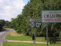
Oklahoma
Oklahoma is a state located in the South Central region of the United States of America. With an estimated 3,751,351 residents as of the 2010 census and a land area of 68,667 square miles , Oklahoma is the 28th most populous and 20th-largest state...
–Arkansas
Arkansas
Arkansas is a state located in the southern region of the United States. Its name is an Algonquian name of the Quapaw Indians. Arkansas shares borders with six states , and its eastern border is largely defined by the Mississippi River...
state line. At the northern end of this border Oklahoma State Highway 20 runs concurrently with Arkansas Highway 43 and the two roads run north–south along the boundary.
In some states, a concurrency can occur between an Interstate
Interstate Highway System
The Dwight D. Eisenhower National System of Interstate and Defense Highways, , is a network of limited-access roads including freeways, highways, and expressways forming part of the National Highway System of the United States of America...
highway and a state toll road. For example, much of the New Jersey Turnpike
New Jersey Turnpike
The New Jersey Turnpike is a toll road in New Jersey, maintained by the New Jersey Turnpike Authority. According to the International Bridge, Tunnel and Turnpike Association, the Turnpike is the nation's sixth-busiest toll road and is among one of the most heavily traveled highways in the United...
is concurrent with I-95
Interstate 95 in New Jersey
Interstate 95 is a major Interstate Highway that traverses the full extent of the East Coast of the United States, from Florida to Maine...
, and portions of the New York State Thruway
New York State Thruway
The New York State Thruway is a system of limited-access highways located within the state of New York in the United States. The system, known officially as the Governor Thomas E. Dewey Thruway for former New York Governor Thomas E. Dewey, is operated by the New York State Thruway Authority and...
overlap with Interstates 87
Interstate 87
Interstate 87 is a Interstate Highway located entirely within New York State in the United States of America. I-87 is the longest intrastate Interstate highway in the Interstate Highway System. Its southern end is at the Bronx approaches of the Robert F. Kennedy Bridge in New York City...
, 287
Interstate 287
Interstate 287 is an auxiliary Interstate Highway in the U.S. states of New Jersey and New York. It is a partial beltway around New York City, serving the northern half of New Jersey and the counties of Rockland and Westchester in New York...
, 90
Interstate 90
Interstate 90 is the longest Interstate Highway in the United States at . It is the northernmost coast-to-coast interstate, and parallels US 20 for the most part. Its western terminus is in Seattle, at Edgar Martinez Drive S. near Safeco Field and CenturyLink Field, and its eastern terminus is in...
, and 190
Interstate 190 (New York)
Interstate 190 runs 28.34 miles from Interstate 90 near Buffalo, New York to Lewiston, New York via Niagara Falls. Parts of this highway were built on the former rights-of-way of the Lehigh Valley Railroad and the Erie Canal. It is referred to by locals as The One-Ninety...
. The Massachusetts Turnpike
Massachusetts Turnpike
The Massachusetts Turnpike is the easternmost stretch of Interstate 90. The Turnpike begins at the western border of Massachusetts in West Stockbridge connecting with the Berkshire Connector portion of the New York State Thruway...
is concurrent with I-90 for its entire length.
Some Interstate highways are concurrent with a non-Interstate designation in their entirety. Often, the reason is that at the ending of the Interstate highway, the road transitions from freeway to semi-freeway (expressway
Limited-access road
A limited-access road known by various terms worldwide, including limited-access highway, dual-carriageway and expressway, is a highway or arterial road for high-speed traffic which has many or most characteristics of a controlled-access highway , including limited or no access to adjacent...
) or surface street, and the non-Interstate designation continues on the changed road. Sometimes it can be within a segment of a long-distance freeway that zips through a major city.
Here is a list of examples:
- Interstate 27Interstate 27Interstate 27 is an intrastate Interstate Highway, located entirely in the U.S. state of Texas, running north from Lubbock to Interstate 40 in Amarillo. These two cities are the only control cities on I-27; other cities and towns served by I-27 include New Deal, Abernathy, Hale Center, Plainview,...
in TexasTexasTexas is the second largest U.S. state by both area and population, and the largest state by area in the contiguous United States.The name, based on the Caddo word "Tejas" meaning "friends" or "allies", was applied by the Spanish to the Caddo themselves and to the region of their settlement in...
is concurrent with U.S. Route 87U.S. Route 87U.S. Highway 87 is a north–south United States highway that runs for 1,998 miles from northern Montana to southern Texas. Most of the portion from Billings, Montana, to Raton, New Mexico, is co-signed along Interstates 90 and 25...
in its entirety. - Interstate 99Interstate 99Interstate 99 is an intrastate Interstate Highway located in central Pennsylvania in the United States. The southern terminus of the route is at exit 146 of the Pennsylvania Turnpike north of Bedford, where the road continues south as U.S. Route 220 . The northern terminus is at...
in PennsylvaniaPennsylvaniaThe Commonwealth of Pennsylvania is a U.S. state that is located in the Northeastern and Mid-Atlantic regions of the United States. The state borders Delaware and Maryland to the south, West Virginia to the southwest, Ohio to the west, New York and Ontario, Canada, to the north, and New Jersey to...
, concurrent with U.S. Route 220U.S. Route 220U.S. Route 220 is a long U.S. Route in the eastern United States.US 220 is a spur route of U.S. Route 20 but at present, the two routes do not intersect nor do they connect via other spurs of US 20. The former U. S. Route 120, which was signed in Pennsylvania between 1926 and 1967, intersected...
in its entirety. - I-194Interstate 194 (Michigan)Interstate 194 is a three-mile long, north–south freeway between downtown Battle Creek and I-94 in the southern portion of the city. The Michigan Department of Transportation lists its length as long, while the Federal Highway Administration lists it at...
in MichiganMichiganMichigan is a U.S. state located in the Great Lakes Region of the United States of America. The name Michigan is the French form of the Ojibwa word mishigamaa, meaning "large water" or "large lake"....
, concurrent with M-66M-66 (Michigan highway)M-66 is a north–south state trunkline highway on the Lower Peninsula of the US state of Michigan. It runs from the Indiana state line in the south to Charlevoix in the north. M-66 is the only state highway to traverse almost the entire north–south distance of the LP. It starts as a...
in its entirety.
Also, in some cases, two Interstate highways can be concurrent. An example of this is the concurrency of Interstates 20
Interstate 20
Interstate 20 is a major east–west Interstate Highway in the Southern United States. I‑20 runs 1,535 miles from near Kent, Texas, at Interstate 10 to Florence, South Carolina, at Interstate 95...
and 59
Interstate 59
Interstate 59 is an Interstate Highway in the southern United States. Its southern terminus is near Slidell, Louisiana, a suburb of New Orleans, at an intersection with Interstate 10 and Interstate 12, its northern terminus is at Wildwood, Georgia, at an intersection with Interstate 24.The road's...
between west of Birmingham, Alabama
Birmingham, Alabama
Birmingham is the largest city in Alabama. The city is the county seat of Jefferson County. According to the 2010 United States Census, Birmingham had a population of 212,237. The Birmingham-Hoover Metropolitan Area, in estimate by the U.S...
, and east of Meridian, MS. In other cases, instances of arc-shaped bypasses of medium-sized cities can involve concurrencies of Interstate Highways and other route types.
A unique concurrency can be found in Greensboro
Greensboro, North Carolina
Greensboro is a city in the U.S. state of North Carolina. It is the third-largest city by population in North Carolina and the largest city in Guilford County and the surrounding Piedmont Triad metropolitan region. According to the 2010 U.S...
, North Carolina, where Interstate 40
Interstate 40 in North Carolina
Interstate 40 runs through the state of North Carolina from the Tennessee state line in the west to its eastern terminus in Wilmington.-Pigeon River Gorge:...
runs concurrent with Business 85
Interstate 85 Business (North Carolina)
In the U.S. state of North Carolina, Interstate 85 Business is a business loop of Interstate 85; which serves several cities in the Piedmont Triad.-Route description:...
. Business I-85 runs along the former alignment of I-85
Interstate 85 in North Carolina
In the U.S. state of North Carolina, Interstate 85 scales the state for from the South Carolina border to the Virginia border. As the second-longest interstate in the state , it provides an important link between the cities of Atlanta, Georgia, Charlotte, Greensboro, Richmond, Virginia and...
, which has since been rerouted along the Greensboro Urban Loop
Greensboro Urban Loop
The Greensboro Urban Loop is a planned 41-mile beltway around Greensboro, North Carolina, United States. The loop carries Interstate 85 and U.S. Route 421 on its southern section, and Interstate 73 from U.S. 220 to Bryan Boulevard along the west side of Greensboro...
. I-40 was also rerouted along this loop in 2008, but reverted to its original routing shortly afterward.
United Kingdom
In the United KingdomUnited Kingdom
The United Kingdom of Great Britain and Northern IrelandIn the United Kingdom and Dependencies, other languages have been officially recognised as legitimate autochthonous languages under the European Charter for Regional or Minority Languages...
, it is common for major through routes to run concurrently with others. Only one road number (typically that of the more heavily used route) is ever shown on road signs however; the other road is either bracketed on the sign, implying that the major route leads to a junction with the minor route (which it will do at the end of the concurrency), or left off altogether. For example, the A82 runs concurrently with the A85
A85 road
The A85 is a major road in Scotland. It runs east from Oban along the south bank of Loch Etive, through Lochawe and Tyndrum, Crianlarich, Lochearnhead, St Fillans and Crieff before passing through Perth, where it crosses the River Tay via Perth Bridge. Its name between the latter two locations is...
for five miles (8 km) in western Scotland
Scotland
Scotland is a country that is part of the United Kingdom. Occupying the northern third of the island of Great Britain, it shares a border with England to the south and is bounded by the North Sea to the east, the Atlantic Ocean to the north and west, and the North Channel and Irish Sea to the...
. Each route-confirmation sign-header gives the road number as "A82 (A85)". A counter-example is the concurrency of the A6 and A591
A591 road
The A591 is a major road in Cumbria, in the north-west of England. The stretch of the road between Windermere and Keswick has been voted Britain's Favourite Road.-Route:...
south of Kendal
Kendal
Kendal, anciently known as Kirkby in Kendal or Kirkby Kendal, is a market town and civil parish within the South Lakeland District of Cumbria, England...
, where, unusually, a sign gives both roads equal status as "A591/A6".
In central Scotland
Scotland
Scotland is a country that is part of the United Kingdom. Occupying the northern third of the island of Great Britain, it shares a border with England to the south and is bounded by the North Sea to the east, the Atlantic Ocean to the north and west, and the North Channel and Irish Sea to the...
, the M876
M876 motorway
The M876 motorway is a motorway in Scotland. The motorway runs from Denny to Airth in the Falkirk council area, forming an approach road to the Kincardine Bridge. It was opened in 1980....
starts from the M80
M80 motorway
The M80 is a motorway in central Scotland, running through Glasgow, North Lanarkshire, Falkirk and Stirling and links the M8, the M73 and M9 motorways. Following completion in 2011, this road is long. From 1992 - 2011, the road was in two sections; the southern section, Glasgow to Stepps and the...
and shares its middle section with the M9, so that the junction numbers on the M876 run out of sequence: 5, 1, 2, 8, 7, 3.
Canada
Concurrencies are also found in CanadaCanada
Canada is a North American country consisting of ten provinces and three territories. Located in the northern part of the continent, it extends from the Atlantic Ocean in the east to the Pacific Ocean in the west, and northward into the Arctic Ocean...
. In Manitoba
Manitoba
Manitoba is a Canadian prairie province with an area of . The province has over 110,000 lakes and has a largely continental climate because of its flat topography. Agriculture, mostly concentrated in the fertile southern and western parts of the province, is vital to the province's economy; other...
, the Trans-Canada Highway
Trans-Canada Highway
The Trans-Canada Highway is a federal-provincial highway system that joins the ten provinces of Canada. It is, along with the Trans-Siberian Highway and Australia's Highway 1, one of the world's longest national highways, with the main route spanning 8,030 km...
from Winnipeg
Winnipeg
Winnipeg is the capital and largest city of Manitoba, Canada, and is the primary municipality of the Winnipeg Capital Region, with more than half of Manitoba's population. It is located near the longitudinal centre of North America, at the confluence of the Red and Assiniboine Rivers .The name...
to Portage La Prairie is concurrently signed with Yellowhead Highway
Yellowhead Highway
The Yellowhead Highway is a major east-west highway connecting the four western Canadian provinces of British Columbia, Alberta, Saskatchewan, and Manitoba. Although part of the Trans-Canada Highway system, the highway should not be confused with the more southerly, originally-designated...
. In Ontario
Ontario
Ontario is a province of Canada, located in east-central Canada. It is Canada's most populous province and second largest in total area. It is home to the nation's most populous city, Toronto, and the nation's capital, Ottawa....
, the Queen Elizabeth Way
Queen Elizabeth Way
The Queen Elizabeth Way, commonly abbreviated as the QEW, is a 400-Series highway in the Canadian province of Ontario. The freeway links Buffalo, New York and the Niagara Peninsula with Toronto. It begins at the Peace Bridge in Fort Erie and travels around the western shore of Lake Ontario, ending...
and Highway 403
Highway 403 (Ontario)
King's Highway 403, also known as Highway 403, is a 400-series highway in the Canadian province of Ontario that travels between Woodstock and Mississauga, branching off from and reuniting with Highway 401 at both ends and travelling south of it through Hamilton and Mississauga. It is concurrent...
run concurrently between Burlington
Burlington, Ontario
Burlington , is a city located in Halton Region at the western end of Lake Ontario. Burlington is part of the Greater Toronto Area, and is also included in the Hamilton Census Metropolitan Area. Physically, Burlington lies between the north shore of Lake Ontario and the Niagara Escarpment...
and Oakville
Oakville, Ontario
Oakville is a town in Halton Region, on Lake Ontario in Southern Ontario, Canada, and is part of the Greater Toronto Area. As of the 2006 census the population was 165,613.-History:In 1793, Dundas Street was surveyed for a military road...
, forming the province's only concurrency between two 400-series highways
400-series highways (Ontario)
The 400-series highways are a network of controlled-access highways throughout the southern portion of the Canadian province of Ontario, forming a special subset of the provincial highway system. They are analogous to the Interstate Highway System in the United States or the British Motorway...
. King's Highways in Ontario have many concurrencies, as well as county roads that often share concurrent termini or run concurrently for short sections. These are often not signed as such, with the parent route being signed in place of both.
Secondary highways in Ontario rarely even form a concurrency, even with their own kind. Highway 518 instead parallels the Highway 11 freeway in less than a kilometer of it on Highway 11's former surface road as Ontario's secondary highways generally avoid freeway features, except interchanges at them.
Israel
Two freeways, the Trans-Israel HighwayHighway 6 (Israel)
Highway 6 , widely known as the Trans-Israel Highway or Cross-Israel Highway , is a major electronic toll highway in Israel. The highway was officially dedicated as the Yitzhak Rabin Highway , though this name is not commonly used. It started operating in the early 2000s and is being lengthened as...
(Highway 6), and Highway 1
Highway 1 (Israel)
Highway 1 , is the main highway connecting Tel Aviv with Jerusalem.-History:The section between Latrun and Jerusalem roughly follows an ancient path connecting Jaffa and Jerusalem...
run concurrently just east of Ben Shemen Interchange
Ben Shemen Interchange
Ben Shemen Interchange is a major freeway interchange complex in central Israel, connecting Highway 1, Highway 6, Route 443 and Route 444, as well as several local roads. The interchange is located near moshav Ben Shemen and Ben Shemen Forest, hence its name...
. The concurrency is officially designated "Daniel Interchange", providing half of the possible interchange directions. It is a 1 miles (1.6 km) segment consisting of eight lanes providing high-speed access between the two highways. Access from Highway 1 west to Highway 6 south and Highway 6 north to Highway 1 east is provided via Route 431
Route 431 (Israel)
Route 431 , is a suburban freeway in the south of the Tel Aviv Metropolitan Area in Israel. The freeway connects the Ayalon Highway in the west with Highway 1 in the east. It then continues east into Modi'in as a local road....
, while access between Highway 1 east to Highway 6 north and Highway 6 south to Highway 1 west are provided at Ben Shemen Interchange. The other movements are provided through the concurrency.
East of Ashdod, Highway 3
Highway 3 (Israel)
Highway 3 is a highway in Israel. It begins at Beit Horon junction with Highway 443 near Modi'in, it passes through Kiryat Malakhi, and it ends a junction with Highway 4 on the outskirts of Ashkelon.- Plan for the future :...
and Highway 40
Highway 40 (Israel)
Highway 40 is a north-south intercity road in Israel. At 302 km long, it is the second longest highway in Israel, after Highway 90. The highway runs from Kfar Sava in the center of Israel to the Arabah in the south, serving as a main connection between central Israel and Be'er Sheva.-Route...
, both running north–south, converge and cross each other, running concurrently for 2.5 miles (4 km) between Re'em Junction and Malakhi Junction. Southwest of Haifa
Haifa
Haifa is the largest city in northern Israel, and the third-largest city in the country, with a population of over 268,000. Another 300,000 people live in towns directly adjacent to the city including the cities of the Krayot, as well as, Tirat Carmel, Daliyat al-Karmel and Nesher...
, the north–south Highway 70
Highway 70 (Israel)
Highway 70 is a highway in the coastal plain and Western Galilee in northern Israel. It connects the region of Zikhron Ya'akov to the Lower Galilee and to Kiryat Ata and Shlomi near Israel's border with Lebanon.-Description of the route:...
and the east–west Highway 75
Highway 75 (Israel)
Highway 75 is an east-west highway in northern Israel. It passes below the northeast slopes of the Carmel mountains and passes through the Jezreel Valley. It runs from Haifa in the west to Nazareth in the east...
run concurrently for 2.5 miles (4 km) between Yagur Junction and HaAmakim Junction.
Wrong-way concurrency
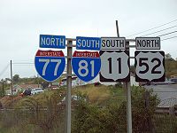
Cardinal direction
The four cardinal directions or cardinal points are the directions of north, east, south, and west, commonly denoted by their initials: N, E, S, W. East and west are at right angles to north and south, with east being in the direction of rotation and west being directly opposite. Intermediate...
, it is possible for two highways signed with opposite, conflicting directions to be running along the same stretch of physical roadway. The road itself is likely to be actually pointed in a third direction.
For example, near Wytheville, Virginia
Wytheville, Virginia
Wytheville is a town in Wythe County, Virginia, United States. The population was 8,211 at the 2010 census. It is the county seat of Wythe County. The town is home to a Chautauqua Festival, held the third weekend in June every year since 1985...
, there is a concurrency between Interstate 77
Interstate 77
Interstate 77 is an Interstate Highway in the eastern United States. It traverses diverse terrain, from the mountainous state of West Virginia to the rolling farmlands of North Carolina and Ohio. It largely supplants the old U.S...
(which runs and is signed north-south) and Interstate 81
Interstate 81
Interstate 81 is an Interstate Highway in the eastern part of the United States. Its southern terminus is at Interstate 40 in Dandridge, Tennessee; its northern terminus is on Wellesley Island at the Canadian border, where the Thousand Islands Bridge connects it to Highway 401, the main freeway...
(which runs primarily northeast-southwest but is also signed north-south). The road itself is oriented east-west and carries the two Interstates signed in opposite directions. So one might simultaneously be on I-77 north and I-81 south, while actually traveling due west. Another well-traveled example is the I-580
Interstate 580 (California)
Interstate 580 is an 80-mile east–west Interstate Highway in Northern California. The heavily traveled spur route of Interstate 80 runs from San Rafael in the San Francisco Bay Area to Interstate 5 near Tracy in the Central Valley...
and I-80 concurrency in the Bay Area of California
California
California is a state located on the West Coast of the United States. It is by far the most populous U.S. state, and the third-largest by land area...
, known locally as the Eastshore Freeway, which travels north-south along the shoreline of San Francisco Bay
San Francisco Bay
San Francisco Bay is a shallow, productive estuary through which water draining from approximately forty percent of California, flowing in the Sacramento and San Joaquin rivers from the Sierra Nevada mountains, enters the Pacific Ocean...
.
At least two roads run concurrently with their own opposite direction. A short stretch of Broadway in Pawtucket, Rhode Island
Pawtucket, Rhode Island
Pawtucket is a city in Providence County, Rhode Island, United States. The population was 71,148 at the 2010 census. It is the fourth largest city in the state.-History:...
, carries both directions of Route 114, and a short stretch of eastbound Interstate 376
Interstate 376
Interstate 376 is a major auxiliary route of the Interstate Highway System in the U.S. state of Pennsylvania, located entirely within the Allegheny Plateau. It runs from I-80 near Sharon south and east to a junction with the Pennsylvania Turnpike in Monroeville, after having crossed the Turnpike...
, as well as the ramps leading to it, in Pittsburgh, Pennsylvania
Pittsburgh, Pennsylvania
Pittsburgh is the second-largest city in the US Commonwealth of Pennsylvania and the county seat of Allegheny County. Regionally, it anchors the largest urban area of Appalachia and the Ohio River Valley, and nationally, it is the 22nd-largest urban area in the United States...
, carries both directions of U.S. Route 19 Truck
U.S. Route 19 Truck (Pittsburgh, Pennsylvania)
U.S. Route 19 Truck is a truck route route of U.S. Route 19 located in Western Pennsylvania in the Pittsburgh Metro Area that has a length of . It is a loop off US 19; the southern terminus located in Mt. Lebanon and the northern terminus in McCandless Township, connecting to US 19 at both ends...
.
An unusual example of a three-directional concurrency occurs near the town of Starks, Illinois
Starks, Illinois
Starks, Illinois, is an unincorporated community in Kane County in the U.S. state of Illinois, located just south of the McHenry County border. Hampshire lies to its northwest, and Pingree Grove lies to its southeast....
. To take advantage of an underpass beneath a railroad, US Route 20, Illinois Route 72
Illinois Route 72
Illinois Route 72 is an east–west state road in northeastern Illinois. It runs from the intersection with Illinois Route 73 north of Lanark east to Illinois Route 43 in Chicago...
and Illinois Route 47
Illinois Route 47
Illinois Route 47 is a largely rural north–south state highway that runs from the Wisconsin state border at Highway 120 near Hebron, to Illinois Route 10, just south of Interstate 72 near Seymour. This is a distance of . Even though Route 47 is primarily rural, in several suburbs of Chicago,...
all converge. The net result is that a driver can be traveling east on US 20, west on IL 72, and south on IL 47 (the actual compass direction) all at the same time.
Canada also possesses at least four wrong-way concurrencies: an 11 km (6.8 mi) stretch of Saskatchewan
Saskatchewan
Saskatchewan is a prairie province in Canada, which has an area of . Saskatchewan is bordered on the west by Alberta, on the north by the Northwest Territories, on the east by Manitoba, and on the south by the U.S. states of Montana and North Dakota....
Highways 2
Saskatchewan Highway 2
Highway 2 is a provincial highway in the Canadian province of Saskatchewan. It is the longest Saskatchewan Highway, at 809 km . The highway is partially divided and undivided. However, only about near Moose Jaw, near Chamberlain, and near Prince Albert are divided highway...
and 11
Saskatchewan Highway 11
Highway 11 is a major north-south highway in Saskatchewan, Canada that connects the province's three largest cities: Regina, Saskatoon and Prince Albert. It is a structural pavement major arterial highway which is approximately long. It is also known as the Louis Riel Trail after the 19th century...
between Chamberlain
Chamberlain, Saskatchewan
Chamberlain is a village in south-central Saskatchewan, Canada. Health Department statistics for 2003 put its population at 116 and the new census of 2006 cites 108 for the new population....
and Findlater
Findlater, Saskatchewan
-Notable people:*Joy Coghill , O.C., is a Canadian actor, director, and writer.- See also :* List of communities in Saskatchewan* Villages of Saskatchewan-External links:*******-Footnotes:...
, a 7 km (4.3 mi) stretch of British Columbia
British Columbia
British Columbia is the westernmost of Canada's provinces and is known for its natural beauty, as reflected in its Latin motto, Splendor sine occasu . Its name was chosen by Queen Victoria in 1858...
Highways 5 and 97 in Kamloops, a 10 km (6.2 mi) segment of New Brunswick
New Brunswick
New Brunswick is one of Canada's three Maritime provinces and is the only province in the federation that is constitutionally bilingual . The provincial capital is Fredericton and Saint John is the most populous city. Greater Moncton is the largest Census Metropolitan Area...
Route 8
New Brunswick Route 8
Route 8 is an important highway link between northern and southern New Brunswick, Canada. 255 kilometres long, it runs from Fredericton to Bathurst via Miramichi.-Route description:...
and Route 117 in Miramichi
Miramichi, New Brunswick
Miramichi is the largest city in northern New Brunswick, Canada. It is situated at the mouth of the Miramichi River where it enters Miramichi Bay...
and 5.5 km (3.4 mi) segment of Highway 6 and Highway 21 west of Owen Sound, Ontario
Ontario
Ontario is a province of Canada, located in east-central Canada. It is Canada's most populous province and second largest in total area. It is home to the nation's most populous city, Toronto, and the nation's capital, Ottawa....
.
Concurrency extremes
Some concurrencies have extreme examples such as triple, and even quadruple concurrencies. A triple Interstate concurrency is found north of Madison, WI, with I-39Interstate 39
Interstate 39 is a highway in the midwestern United States. I-39 runs from Normal, Illinois at Interstate 55 to Highway 29 in Rothschild, Wisconsin, approximately six miles south of Wausau. I-39 was designed to replace US Highway 51, which in the early 1980s was one of the busiest two-lane...
, I-90
Interstate 90 in Wisconsin
In the U.S. state of Wisconsin, Interstate 90 runs east–west through the western, central and southern portions of the state. A total of of Interstate 90 lie in Wisconsin.-Route description:...
, and I-94
Interstate 94 in Wisconsin
In the U.S. state of Wisconsin, Interstate 94 runs east–west through the western, central and southeastern portions of the state.-Route description:A total of of Interstate 94 lie in Wisconsin....
. Also in Madison, there is a quadruple concurrency with four US Highways: US 12
U.S. Route 12 in Wisconsin
In the U.S. state of Wisconsin, U.S. Route 12 runs east–west across the western to southeast portions of the state...
, US 14
U.S. Route 14 in Wisconsin
In the U.S. state of Wisconsin, U.S. Route 14 runs northwest-southeast across the western to southwest portions of the state. It links La Crosse and the southwestern portion of the state with Madison and Janesville...
, US 18
U.S. Route 18 in Wisconsin
In the U.S. state of Wisconsin, U.S. Route 18 runs east–west across the southern part of the state. The highway serves as major connecting route between Madison and the southwest corner of the state...
, and US 151
U.S. Route 151
U.S. Route 151 is a U.S. Highway that runs through the states of Iowa and Wisconsin. The southern terminus for U.S. 151 is at a junction with Interstate 80 in Iowa County, Iowa, and its northern terminus is at Manitowoc, Wisconsin. The route, from south to north follows a northeasterly path through...
along the Beltline south of the city. St. Louis, Missouri
St. Louis, Missouri
St. Louis is an independent city on the eastern border of Missouri, United States. With a population of 319,294, it was the 58th-largest U.S. city at the 2010 U.S. Census. The Greater St...
, has an example of a quadruple Interstate concurrency, with I-44
Interstate 44 in Missouri
In the U.S. state of Missouri, Interstate 44 runs northeast from the Oklahoma state line near Joplin to Interstate 55 in downtown St. Louis. It runs for a total of 290 miles in Missouri.-Route description:...
, I-55
Interstate 55 in Missouri
In the U.S. state of Missouri, Interstate 55 runs from the Arkansas state line to the Poplar Street Bridge over the Mississippi River in St. Louis.-Route description:...
, I-64
Interstate 64 in Missouri
In the U.S. state of Missouri, Interstate 64 passes through in the St. Louis area. The entire route overlaps U.S. Route 40. Because the road was a main thoroughfare in the St. Louis area before the development of the Interstate Highway System, it is not uncommon for locals to refer to the stretch...
, and I-70
Interstate 70 in Missouri
In the U.S. state of Missouri, Interstate 70 is generally parallel to the Missouri River. This section of the transcontinental Interstate has its western terminus at the Kansas state line on the Lewis and Clark Viaduct, concurrent with U.S...
, plus US 40 running concurrently for a brief run downtown. I-25
Interstate 25
Interstate 25 is an Interstate Highway in the western United States. It is primarily a north–south highway. I-25 stretches from Interstate 10 at Las Cruces, New Mexico, , to Interstate 90 in Buffalo, Wyoming, .Interstate 25 is the main north–south expressway through...
is concurrent with US 87
U.S. Route 87
U.S. Highway 87 is a north–south United States highway that runs for 1,998 miles from northern Montana to southern Texas. Most of the portion from Billings, Montana, to Raton, New Mexico, is co-signed along Interstates 90 and 25...
for 400 miles (643.7 km), running from Raton, New Mexico
Raton, New Mexico
Raton is a city in Colfax County, New Mexico, United States. The population was 7,282 at the 2000 census. It is the county seat of Colfax County. The city is located just south of Raton Pass.-Name:...
through the entire state of Colorado
Colorado
Colorado is a U.S. state that encompasses much of the Rocky Mountains as well as the northeastern portion of the Colorado Plateau and the western edge of the Great Plains...
and all the way to I-25's northern terminus at I-90 in Buffalo, Wyoming
Buffalo, Wyoming
Buffalo is a city in Johnson County, Wyoming, United States. The population was 3,900 at the 2000 census. It is the county seat of Johnson County...
, although US 87 is unsigned for most of this distance. The longest Interstate highway concurrency is I-80
Interstate 80
Interstate 80 is the second-longest Interstate Highway in the United States, following Interstate 90. It is a transcontinental artery running from downtown San Francisco, California to Teaneck, New Jersey in the New York City Metropolitan Area...
and I-90
Interstate 90
Interstate 90 is the longest Interstate Highway in the United States at . It is the northernmost coast-to-coast interstate, and parallels US 20 for the most part. Its western terminus is in Seattle, at Edgar Martinez Drive S. near Safeco Field and CenturyLink Field, and its eastern terminus is in...
for 265 miles (426.5 km) across Indiana
Indiana
Indiana is a US state, admitted to the United States as the 19th on December 11, 1816. It is located in the Midwestern United States and Great Lakes Region. With 6,483,802 residents, the state is ranked 15th in population and 16th in population density. Indiana is ranked 38th in land area and is...
and Ohio
Ohio
Ohio is a Midwestern state in the United States. The 34th largest state by area in the U.S.,it is the 7th‑most populous with over 11.5 million residents, containing several major American cities and seven metropolitan areas with populations of 500,000 or more.The state's capital is Columbus...
. One of the shorter examples is the M-35 (Michigan highway)
M-35 (Michigan highway)
M-35 is a state trunkline highway in the Upper Peninsula of the US state of Michigan. Running for in a general north–south direction, it connects the cities of Menominee, Escanaba and Negaunee. The southern section of M-35 in Menominee and Delta counties carries two additional designations...
overlap with CR 492
County Road 492 (Marquette County, Michigan)
County Road 492 is a primary county road in Marquette County, Michigan. The road serves as an alternate route between Negaunee and Marquette. Several historic sites line the roadway as it runs south and parallel to the main highway, U.S. Highway 41 through the Marquette Range in Michigan's Upper...
in Marquette County, Michigan
Marquette County, Michigan
-National protected areas:* Hiawatha National Forest * Huron National Wildlife Refuge* Ottawa National Forest -University:Northern Michigan University is a four-year university, established in 1899, located in Marquette, Michigan, on Michigan's Upper Peninsula...
. The two roads overlap for 153 feet (46.6 m) to cross a rail line, with M-35 yielding to CR 492 traffic in the process.
I-465
Interstate 465
Interstate 465 , also known as the USS Indianapolis Memorial Highway, is the beltway circling Indianapolis, Indiana, United States. It is roughly rectangular in shape and has a perimeter of approximately 53 miles . It lies almost completely within the boundaries of Marion County, except for two...
around Indianapolis
Indianapolis
Indianapolis is the capital of the U.S. state of Indiana, and the county seat of Marion County, Indiana. As of the 2010 United States Census, the city's population is 839,489. It is by far Indiana's largest city and, as of the 2010 U.S...
currently has the most concurrent routes. Portions of the 53 miles (85.3 km) highway overlap with I-74, US 31
U.S. Route 31
U.S. Route 31 is a long north–south highway connecting northern Michigan to southern Alabama, with its northern terminus at Interstate 75 near Mackinaw City, Michigan, and southern terminus at the combined U.S. Route 90 & U.S. Route 98 at Spanish Fort, Alabama...
, US 36
U.S. Route 36
U.S. Route 36 is an east–west United States highway that runs for from Rocky Mountain National Park, Colorado to Uhrichsville, Ohio. The highway's western terminus is at Deer Ridge Junction, an intersection in Rocky Mountain National Park, Colorado, where it meets U.S. Route 34. Its eastern...
, US 40
U.S. Route 40
U.S. Route 40 is an east–west United States highway. As with most routes whose numbers end in a zero, U.S. 40 once traversed the entire United States. It is one of the original 1920s U.S. Highways, and its first termini were San Francisco, California, and Atlantic City, New Jersey...
, US 52
U.S. Route 52
U.S. Route 52 is a United States highway that runs across the northern, eastern and southeastern regions of the United States. Contrary to most other even-numbered U.S...
, US 421
U.S. Route 421
U.S. Route 421 is a spur route of U.S. 21. It runs for from Michigan City, Indiana, at U.S. 20, to Fort Fisher in North Carolina. The highway goes through the cities of Indianapolis, Indiana, Lexington, Kentucky, Boone, North Carolina, Winston-Salem, North Carolina, Greensboro, North Carolina and...
, SR 37
Indiana State Road 37
State Road 37 in the U.S. State of Indiana is a major route in Indiana, running as a 4-lane divided highway for 110 miles of its course....
and SR 67
Indiana State Road 67
State Road 67 in the U.S. State of Indiana cuts a diagonal route from southwest to northeast across the state from the north side of Vincennes to Indianapolis to the Ohio state line, where it becomes State Route 29 east of Bryant.-Route description:...
-- a total of eight other routes. Seven of the eight other designations overlap between exits 46 and 47 to create an eight-way concurrency.
Consolidation plans for concurrencies
M-47 (Michigan highway)
M-47 is a north–south state trunkline highway in the US state of Michigan. It runs near Saginaw and Midland in the Tri-Cities area of the Lower Peninsula. The highway runs through suburban and agricultural areas to connect the two cities with the airport in the area. The northernmost section of...
in Michigan
Michigan
Michigan is a U.S. state located in the Great Lakes Region of the United States of America. The name Michigan is the French form of the Ojibwa word mishigamaa, meaning "large water" or "large lake"....
used to run concurrently with M-46
M-46 (Michigan highway)
M-46 is an east–west state trunkline highway in the US state of Michigan between Muskegon and Port Sanilac, terminating near Lake Michigan and Lake Huron on each end. Except for the north–south segment that corresponds with the US Highway 131 freeway between Cedar Springs and Howard City, M-46 is...
for only a few miles. Meanwhile, there was a gap between M-52
M-52 (Michigan highway)
M-52 is a north–south state trunkline highway in the US state of Michigan. The southern terminus is on the Ohio border, where it continues as State Route 109 . The highway passes through communities like Adrian, where it intersects US Highway 223 , Chelsea and Webberville along its course...
's northern terminus at M-36
M-36 (Michigan highway)
M-36 is a state trunkline route in the Lower Peninsula of the US state of Michigan that runs in a west–east direction from Mason to Whitmore Lake. The route connects US 127 south of Lansing and US 23 north of Ann Arbor-Route description:...
and M-47's southern terminus at I-96
Interstate 96
Interstate 96 is an intrastate Interstate Highway that is entirely within the US state of Michigan. Its western terminus is at an interchange with US Highway 31 and Business US Highway 31 , on the western boundary of Norton Shores southeast of Muskegon. Its eastern terminus is at I-75 near the...
during the 1960s. This gap was closed, connecting M-52 northward to the southern section of M-52. The M-47 designation replaced the M-52 designation northward to the junction with M-46, at the same time M-47 was shortened to end at the other end of the M-46/M-47 concurrency.
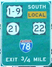
Other consolidation schemes involve the use of incorporating 2 single digit numbers into one shield, as along the U.S. Route 1/9
U.S. Route 1/9
U.S. Route 9 is a U.S. highway in the northeast United States, running from Laurel, Delaware north to the Canadian border near Champlain, New York...
concurrency in northern New Jersey
New Jersey
New Jersey is a state in the Northeastern and Middle Atlantic regions of the United States. , its population was 8,791,894. It is bordered on the north and east by the state of New York, on the southeast and south by the Atlantic Ocean, on the west by Pennsylvania and on the southwest by Delaware...
. Also, some plans have involved leaving some route types unsigned since they are entirely on a brief stretch of a long-distance highway in a large city, for instance Interstate 296
Interstate 296
Interstate 296 is a part of the Interstate Highway System in the US state of Michigan. It is a state trunkline highway that runs for entirely within the Grand Rapids area. Its termini are I-96 on the north side of Grand Rapids in Walker and I-196 near downtown Grand Rapids. The entire length is...
described above is entirely concurrent with U.S. Route 131
U.S. Route 131
US Highway 131 is a north–south United States Highway, of which all but 0.67 miles of its 266.82 miles are within the state of Michigan. The highway starts in rural Indiana south of the state line as a state road connection to the Indiana Toll Road...
, and was left unsigned since it would have been superfluous as a guide for travelers in the area.