
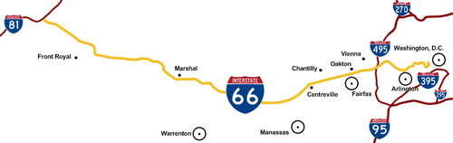
Interstate 66
Encyclopedia
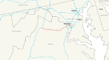
Interstate 66 is an Interstate Highway in the eastern United States
. As indicated by its even route number, it runs in an east–west direction. Its western terminus is at Middletown, Virginia
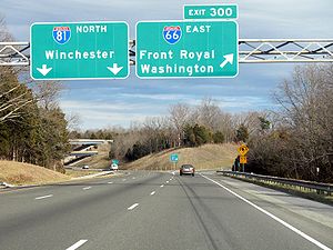
, at an intersection with Interstate 81
; its eastern terminus is in Washington, D.C.
, at an intersection with U.S. Route 29. Interstate 66 has no physical or historical connection to U.S. Route 66
.
The E Street Expressway is a spur from Interstate 66 into the Foggy Bottom
neighborhood of Washington, D.C.
|-
|VA
|75
|121
|-
|DC
|2
|3
|-
|Total
|77
|124
|}
 Because I-66 is the only Interstate Highway running west from Washington, D.C.
, into Northern Virginia
, traffic on the road is often extremely heavy. For decades, there has been talk of widening I-66 from 2 to 3 lanes each way inside the Capital Beltway (Interstate 495)
through Arlington, Virginia
, although many Arlington residents are adamantly opposed to this plan.
In 2005, the Virginia Department of Transportation
(VDOT) studied the prospect of implementing a one-lane-plus-shoulder extension on westbound I-66 within the Beltway (in an attempt to reduce congestion for people commuting away from D.C.).
In the summer of 2010, construction began on a third lane and a 12-foot shoulder lane between the Fairfax Drive ramp near the George Mason Drive entrance ramp to I-66 west and the Sycamore Street ramp, a 1.9 mile distance. The entrance ramp acceleration lane and the exit ramp deceleration lane are being lengthened until they meet to form a continuous lane between both ramps. The 12-foot shoulder lane will carry emergency vehicles and can be used in emergency situations. This project is scheduled for completion in December 2011.
The Orange Line
and the Silver Line
(under construction) of the Washington Metro
operate in the median of the highway in Fairfax and Arlington counties. Four stations (Vienna, Dunn Loring, West Falls Church, and East Falls Church) are located along this segment of I-66.
I-66 east has two exit ramps, one from each side of the highway, to the Inner Loop of I-495 heading northbound. One is a two lane right exit which merges down to one lane halfway along the ramp, while a second exit ramp is a left exit; the latter reserved for use by high-occupancy vehicle (HOV) traffic during morning rush hour, but open to all traffic excluding trucks at all other times. Both exit ramps for the Inner Loop merge prior to merging from the left with the Inner Loop. There is no access from the Outer Loop of I-495 to I-66 east; traffic wishing to make this movement must use State Route 267 east.
I-66 east also has two exits, one from each side of the highway, to the Outer Loop of I-495. One is a right exit, while one is a left exit; the latter shares a ramp with the exit to the Inner Loop of I-495.
I-66 is named the "Custis Memorial Parkway" east of the Capital Beltway in Virginia. The name commemorates the Custis family, several of whose members (including Martha Dandridge Custis Washington
, George Washington Parke Custis
, Eleanor (Nellie) Parke Custis Lewis
and Mary Anna Randolph Custis Lee
) played prominent roles in Northern Virginia's
history.
and the Capital Beltway, the left lane on eastbound I-66 is reserved for vehicles with two or more occupants (HOV-2 traffic) from 5:30 to 9:30 a.m., and the left lane on westbound I-66 is reserved for HOV-2 traffic from 3:00 to 7:00 p.m. The eastbound shoulder lane (far right lane) between US 50
in Fairfax, Virginia
and the Beltway is open to all traffic from 5:30 to 11:00 a.m. The westbound shoulder lane (far right lane), also between the Capital Beltway and U.S. Route 50, is open to all traffic from 2:00 to 8:00 p.m.
Between the Beltway and the Theodore Roosevelt Bridge
, the entire eastbound (inbound) roadway is reserved for HOV-2 and Washington Dulles International Airport
traffic from 6:30 to 9:00 a.m., and the entire westbound (outbound) roadway is reserved for HOV-2 and Dulles Airport traffic from 4:00 to 6:30 p.m. This is enforced by random police presence on the on- and off-ramps, because single-passenger vehicles are allowed to enter the highway inside the Beltway in the direction of rush-hour traffic when they intend to use the Dulles Access Road at exit 67. Police heavily monitor the three-mile stretch between the Dulles Access Road and the Beltway for violations, frequently having traffic slow down to visually inspect inside each vehicle.
Both motorcycles and qualified "clean special fuel" vehicles are permitted to use HOV-2 facilities on I-66 during times when HOV regulations are in effect even without the required number of occupants. The "clean special fuel" designation is used primarily by hybrid vehicle
s, but is also available for vehicles using alternative fuels such as natural gas
or electricity
. To qualify for the HOV exemption, a vehicle owner must specifically request the designation when registering the vehicle, pay the appropriate fees, and display a "clean special fuel" license plate. The clean-fuel exemption is scheduled to expire on June 30, 2012, although the Virginia General Assembly
has extended the exemption every year, one year at a time, since it was originally designated to expire in 2006. However, in 2011, the exemption was modified so it applies only to clean fuel vehicles registered before June 30, 2011. Clean-fuel vehicles registered after that date are not exempt from HOV regulations on I-66.
As of January 28, 2011, penalties for HOV violators range from $125 on the first offense to $250 on the second offense, $500 on the third offense, and $1,000 on the fourth offense. Violators also receive three points on their driving record on the second and later offenses.
freeway. After crossing the Potomac River
on the Theodore Roosevelt Bridge
concurrent with US 50, the route quickly turns north, separating from US 50. The highway interchanges with the E Street Expressway spur before passing beneath Virginia Avenue in a short tunnel. After an indirect interchange with the Rock Creek Parkway (via 27th Street), the highway terminates at a pair of ramps leading to the Whitehurst Freeway (US 29) and L Street.
This is the only 2 digit Interstate to enter the District of Columbia, other than the 100 yards (91.4 m) or so that I-95
passes through DC on the Woodrow Wilson Bridge
(part of the Capital Beltway).
The eastern terminus of the E Street Expressway is at 20th Street NW. From there, traffic continues along E Street NW to 17th Street NW near the White House
, the Old Executive Office Building
, and the Corcoran Gallery of Art
. Westbound traffic from 17th Street takes a one-block segment of New York Avenue
to the expressway entrance at 20th and E Streets. The expressway and the connecting portions of E Street and New York Avenue are part of the National Highway System
.
 As with many urban Interstate Highway projects, I-66 has encountered opposition from local citizen groups.
Most notably for I-66 was the construction through Arlington
, Virginia, proposed in 1956. After the Virginia Department of Transportation
(VDOT) (then known as the Virginia Department of Highways) acquired two sections of the former route of the Washington and Old Dominion Railroad
to provide a right-of-way through Arlington for the new highway, the Arlington Coalition on Transportation
(ACT) filed a lawsuit in Federal District Court
in 1971 opposing the Arlington portion of the project. The group objected to that urban segment due to concerns over air quality, noise
and community cohesion changes. In 1972 the U.S. Fourth Circuit Court of Appeals ruled in favor of ACT, technically blocking any construction. The U.S. Supreme Court
upheld the ruling in favor of ACT later in 1972.
The impasse was eventually broken when the parties agreed on experts to conduct air quality and noise
studies for VDOT; the firm of ESL Inc., the expert hired originally by ACT, was agreed upon to be hired by VDOT. Then, U.S. Secretary of Transportation Coleman personally intervened in 1976 with negotiations to reach a compromise of a reduced highway width including a transit element.
Less controversial was the portion of the highway's route immediately west of Arlington. There, VDOT decided to curve the highway to bypass the City of Falls Church
, increasing the highway's length while sparing the city from the road's immediate environmental impacts.
In Gainesville, Virginia, the Gainesville Interchange Project is taking place at and near the interchange between US 29
and I-66, aiming to upgrade facilities for those and many other roads due to rapid development and accompanying heavy traffic in the Gainesville
and Haymarket
area. I-66's overpasses were reconstructed to accommodate nine lanes (six general purpose, two HOV, one collector-distributor eastbound) and lengthened for the expansion of US 29 to six lanes. These alterations were completed in June 2010. US 29 is also planned to be largely grade-separated in the area, including an interchange at its current intersection with SR 619
(Linton Hall Road); land for this has been acquired. The project overall began in 2004 and completion is slated for late 2014.
.svg.png)
 In Washington D.C., I-66 was planned to extend east of its current terminus along the North Leg of the Inner Loop
freeway. I-66 would have also met the eastern terminus of a planned Interstate 266 at US 29, and the western terminus of the South Leg Freeway (I-695) at US 50; I-266 would have been a parallel route to I-66, providing more direct access to the North Leg from points west, while I-695 would have been an inner-city connector between I-66 and I-95.
The final plans for the North Leg Freeway, as published in 1971, outlined a 1.5 miles (2.4 km) six-lane tunnel beneath K Street, between I-266/US 29 and New York Avenue, where the North Leg would emerge from the tunnel and join with the Center Leg Freeway (formerly I-95, now I-395); the two routes would run concurrently for three-fourths of a mile before reaching the Union Station
interchange, where I-66 was planned to terminate.
Despite the plan to route the North Leg in a tunnel beneath K Street, the intense opposition to previous, scrapped alignments for the D.C. freeway network, which included previous alignments for the North Leg Freeway, led to the mass cancellation of all unbuilt D.C. freeways in 1977, resulting in the truncation of I-66 at US 29.
!County
!Location
!Mile
!#
!Destinations
!Notes
|-
|Frederick
|Middletown
|0.0
|1
|
|Westbound exit and eastbound entrance, and signed as exits 1A (south, Roanoke) and 1B (north, Winchester)
|-
|rowspan=2|Warren
|Front Royal
|6.4
|6
|
|
|-
|
|12.9
|13
|
|
|-
|rowspan=5|Fauquier
|
|18.5
|18
|
|
|-
|
|23.3
|23
|
|West end of US 17/SR 55 overlap
|-
|rowspan=2|Marshall
|27.0
|27
|
|East end of SR 55 overlap
|-
|28.3
|28
|
|East end of US 17 overlap
|-
|The Plains
|31.3
|31
|
|
|-
|rowspan=5|Prince William
|Haymarket
|40.5
|40
|
|
|-
|Gainesville
|43.1
|43
|
|Signed as exits 43A (south, Gainesville) and 43B (north, Charlottesville)
|-
|rowspan=2|Manassas
|44.5
|44
|
|West end of SR 234 overlap
|-
|47.3
|47
|
|East end of SR 234 overlap; signed as exits 47A (Manassas) and 47B (Bussines) westbound
|-
|Yorkshire
|48.8
|
|Rest Area
|At entrance to Prince William County from Fairfax County; both sides now reopened
|-
|rowspan=11|Fairfax
|rowspan=2|Centreville
|52.1
|52
|
|
|-
|53.2
|53
| – Dulles Airport, Centreville
|No access to SR 28 south from I-66 east; westbound exits signed 53A (south) and 53B (north)
|-
|rowspan=2|Fair Lakes
|54.9
|
|
|Eastbound left entrance open only to HOV-2+ traffic weekdays from 5:30 to 9:30 a.m. Westbound left exit open all other times; exit restricted to HOV-2+ traffic weekdays from 3:00 to 7:00 p.m.
|-
|55.9
|55
|
|Signed as exits 55A (south, Springfield, Reston) and 55B (north, Herndon)
|-
|rowspan=3|Fairfax
|57.1
|
|
|Eastbound left entrance open only to HOV-2+ traffic weekdays from 5:30 to 9:30 a.m. Westbound left exit open all other times; exit restricted to HOV-2+ traffic weekdays from 3:00 to 7:00 p.m.
|-
|58.1
|57
|
|Signed as exits 57A (east, Fair Oaks) and 57B (west, Fairfax, Winchester)
|-
|60.1
|60
|
|
|-
|Vienna
|62.5
|62
|
|
|-
|Dunn Loring
|65.1
|64
|, Baltimore
|Left and right exit eastbound (left from HOV lane); no westbound exit to I-495 north and eastbound entrance from I-495 south; signed as exits 64A (south) and 64B (north) eastbound
|-
|Tysons Corner
|66.0
|66
|
|Signed as exits 66A (east, Falls Church) and 66B (west) westbound
|-
|Falls Church
|66.6
|67
| – Dulles Airport
|Westbound exit and eastbound entrance
|-
|rowspan=7 colspan=2|Arlington
|67.8
|68
|Westmoreland Street
|Eastbound exit and westbound entrance
|-
|68.4
|69
|
|
|-
|70.5
|71
|
|
|-
|72.1
|72
|
|Eastbound exit and westbound entrance
|-
|73.1
|73
|
|No eastbound exit to US 29 south and westbound entrance from US 29 north
|-
|74.2
|75
|
|Eastbound exit and westbound entrance
|-
|74.5
|
|
|West end of US 50 overlap; westbound exit and eastbound entrance
|-
|colspan=6 align=center|State line
|-
|rowspan=8 colspan=2|Washington
|74.9
|
|Independence Avenue
|
|-
|75.0
|
|
|East end of US 50 overlap; eastbound exit and westbound entrance
|-
|75.2
|
|E Street Expressway
|
|-
|75.0
|
|Whitehurst Freeway
|
|-
|74.6
|
|Rock Creek Parkway
|Eastbound exit and westbound entrance
|-
|75.7
|
|Pennsylvania Avenue / L Street NW
|Eastbound exit and westbound entrance
|-
|75.8
|
|
|Westbound exit and eastbound entrance
|-
|76.0
|
|M street NW
|At-grade intersection
|-
, and Arlington County, Virginia
. District of Columbia officials proposed designating the route Interstate 66N, a move opposed by the American Association of State Highway and Transportation Officials
. In Virginia, Interstate 266 would have split off from Interstate 66 just east of the present Spout Run Parkway exit. From there, it would have followed an expanded Spout Run Parkway, crossed the George Washington Memorial Parkway, and crossed the Potomac River
across a new bridge that would have been called the Three Sisters Bridge. Upon entering the District of Columbia, it would have followed Canal Road and an expanded Whitehurst Freeway to rejoin Interstate 66 at K Street. Interstate 266 was canceled in 1972 in the face of community opposition during Washington's "freeway revolts
".http://www.roadstothefuture.com/roadsnova/266.htmlhttp://www.kurumi.com/roads/3di/ix66.html#266va
United States
The United States of America is a federal constitutional republic comprising fifty states and a federal district...
. As indicated by its even route number, it runs in an east–west direction. Its western terminus is at Middletown, Virginia
Middletown, Virginia
Middletown is a town in Frederick County, Virginia, United States. The population was 1,265 at the 2010 census.- History :Belle Grove Plantation, about a mile southwest of Middletown, was first settled in about 1750 and its historic Federal-style manor house was completed in 1797...
, at an intersection with Interstate 81
Interstate 81
Interstate 81 is an Interstate Highway in the eastern part of the United States. Its southern terminus is at Interstate 40 in Dandridge, Tennessee; its northern terminus is on Wellesley Island at the Canadian border, where the Thousand Islands Bridge connects it to Highway 401, the main freeway...
; its eastern terminus is in Washington, D.C.
Washington, D.C.
Washington, D.C., formally the District of Columbia and commonly referred to as Washington, "the District", or simply D.C., is the capital of the United States. On July 16, 1790, the United States Congress approved the creation of a permanent national capital as permitted by the U.S. Constitution....
, at an intersection with U.S. Route 29. Interstate 66 has no physical or historical connection to U.S. Route 66
U.S. Route 66
U.S. Route 66 was a highway within the U.S. Highway System. One of the original U.S. highways, Route 66 was established on November 11, 1926 -- with road signs erected the following year...
.
The E Street Expressway is a spur from Interstate 66 into the Foggy Bottom
Foggy Bottom
Foggy Bottom is one of the oldest late 18th and 19th-century neighborhoods in Washington, D.C. The area is thought to have received the name because its riverside location made it susceptible to concentrations of fog and industrial smoke, an atmospheric trait that did not prevent the neighborhood...
neighborhood of Washington, D.C.
Washington, D.C.
Washington, D.C., formally the District of Columbia and commonly referred to as Washington, "the District", or simply D.C., is the capital of the United States. On July 16, 1790, the United States Congress approved the creation of a permanent national capital as permitted by the U.S. Constitution....
Route description
|-
|VA
Virginia
The Commonwealth of Virginia , is a U.S. state on the Atlantic Coast of the Southern United States. Virginia is nicknamed the "Old Dominion" and sometimes the "Mother of Presidents" after the eight U.S. presidents born there...
|75
|121
|-
|DC
Washington, D.C.
Washington, D.C., formally the District of Columbia and commonly referred to as Washington, "the District", or simply D.C., is the capital of the United States. On July 16, 1790, the United States Congress approved the creation of a permanent national capital as permitted by the U.S. Constitution....
|2
|3
|-
|Total
|77
|124
|}
Virginia
Washington, D.C.
Washington, D.C., formally the District of Columbia and commonly referred to as Washington, "the District", or simply D.C., is the capital of the United States. On July 16, 1790, the United States Congress approved the creation of a permanent national capital as permitted by the U.S. Constitution....
, into Northern Virginia
Northern Virginia
Northern Virginia consists of several counties and independent cities in the Commonwealth of Virginia, in a widespread region generally radiating southerly and westward from Washington, D.C...
, traffic on the road is often extremely heavy. For decades, there has been talk of widening I-66 from 2 to 3 lanes each way inside the Capital Beltway (Interstate 495)
Interstate 495 (Capital Beltway)
Interstate 495 is a Interstate Highway that surrounds the United States' capital of Washington, D.C., and its inner suburbs in adjacent Maryland and Virginia. I-495 is widely known as the Capital Beltway or simply the Beltway, especially when the context of Washington, D.C., is clear...
through Arlington, Virginia
Arlington County, Virginia
Arlington County is a county in the Commonwealth of Virginia. The land that became Arlington was originally donated by Virginia to the United States government to form part of the new federal capital district. On February 27, 1801, the United States Congress organized the area as a subdivision of...
, although many Arlington residents are adamantly opposed to this plan.
In 2005, the Virginia Department of Transportation
Virginia Department of Transportation
The Virginia Department of Transportation is the agency of state government responsible for transportation in the state of Virginia in the United States. Headquartered in Downtown Richmond, VDOT is responsible for building, maintaining, and operating the roads, bridges and tunnels in the...
(VDOT) studied the prospect of implementing a one-lane-plus-shoulder extension on westbound I-66 within the Beltway (in an attempt to reduce congestion for people commuting away from D.C.).
In the summer of 2010, construction began on a third lane and a 12-foot shoulder lane between the Fairfax Drive ramp near the George Mason Drive entrance ramp to I-66 west and the Sycamore Street ramp, a 1.9 mile distance. The entrance ramp acceleration lane and the exit ramp deceleration lane are being lengthened until they meet to form a continuous lane between both ramps. The 12-foot shoulder lane will carry emergency vehicles and can be used in emergency situations. This project is scheduled for completion in December 2011.
The Orange Line
Orange Line (Washington Metro)
The Orange Line of the Washington Metro consists of 26 rapid transit stations from Vienna to New Carrollton. It has stations in Fairfax County and Arlington, Virginia, the District of Columbia, and Prince George's County, Maryland. Half of the line's stations are shared with the Blue Line, and over...
and the Silver Line
Silver Line (Washington Metro)
The Dulles Corridor Metrorail Project, formally dubbed the Silver Line, is an extension of the Washington Metro rapid transit system, currently under construction with the goal of providing rapid transit service to Dulles International Airport and Tysons Corner...
(under construction) of the Washington Metro
Washington Metro
The Washington Metro, commonly called Metro, and unofficially Metrorail, is the rapid transit system in Washington, D.C., United States, and its surrounding suburbs. It is administered by the Washington Metropolitan Area Transit Authority , which also operates Metrobus service under the Metro name...
operate in the median of the highway in Fairfax and Arlington counties. Four stations (Vienna, Dunn Loring, West Falls Church, and East Falls Church) are located along this segment of I-66.
I-66 east has two exit ramps, one from each side of the highway, to the Inner Loop of I-495 heading northbound. One is a two lane right exit which merges down to one lane halfway along the ramp, while a second exit ramp is a left exit; the latter reserved for use by high-occupancy vehicle (HOV) traffic during morning rush hour, but open to all traffic excluding trucks at all other times. Both exit ramps for the Inner Loop merge prior to merging from the left with the Inner Loop. There is no access from the Outer Loop of I-495 to I-66 east; traffic wishing to make this movement must use State Route 267 east.
I-66 east also has two exits, one from each side of the highway, to the Outer Loop of I-495. One is a right exit, while one is a left exit; the latter shares a ramp with the exit to the Inner Loop of I-495.
I-66 is named the "Custis Memorial Parkway" east of the Capital Beltway in Virginia. The name commemorates the Custis family, several of whose members (including Martha Dandridge Custis Washington
Martha Washington
Martha Dandridge Custis Washington was the wife of George Washington, the first president of the United States. Although the title was not coined until after her death, Martha Washington is considered to be the first First Lady of the United States...
, George Washington Parke Custis
George Washington Parke Custis
George Washington Parke Custis , the step-grandson of United States President George Washington, was a nineteenth-century American writer, orator, and agricultural reformer.-Family:...
, Eleanor (Nellie) Parke Custis Lewis
Eleanor Parke Custis Lewis
Eleanor Parke Custis Lewis , known as Nelly, was the granddaughter of Martha Washington and the step-granddaughter of George Washington.-Childhood:Nelly was the daughter of John Parke Custis and Eleanor Calvert Custis...
and Mary Anna Randolph Custis Lee
Mary Anna Custis Lee
Mary Anna Randolph Custis Lee was the wife of Confederate General Robert E. Lee.-Biography:Mary Anna Custis Lee was the only surviving child of George Washington Parke Custis, George Washington's step-grandson and adopted son and founder of Arlington House, and Mary Lee Fitzhugh Custis, daughter...
) played prominent roles in Northern Virginia's
Northern Virginia
Northern Virginia consists of several counties and independent cities in the Commonwealth of Virginia, in a widespread region generally radiating southerly and westward from Washington, D.C...
history.
HOV designation and rules
Due to heavy commuter traffic, I-66 features a variety of high-occupancy vehicle (HOV) restrictions. Between US 29 in Gainesville, VirginiaGainesville, Virginia
-Demographics:Gainesville is currently the third-largest CDP in Prince William County. As of the census estimate of 2009, there were 28,662 people, 10,300 households, and 8,604 families residing in the CDP. The population density was 1,150.2 people per square mile . There were 10,300 housing units...
and the Capital Beltway, the left lane on eastbound I-66 is reserved for vehicles with two or more occupants (HOV-2 traffic) from 5:30 to 9:30 a.m., and the left lane on westbound I-66 is reserved for HOV-2 traffic from 3:00 to 7:00 p.m. The eastbound shoulder lane (far right lane) between US 50
U.S. Route 50 in Virginia
U.S. Route 50 is a transcontinental highway which stretches from Ocean City, Maryland to Sacramento, California. In the U.S. state of Virginia, US 50 extends from the border with Washington DC at a Potomac River crossing at Rosslyn in Arlington County to the West Virginia state line near Gore in...
in Fairfax, Virginia
Fairfax, Virginia
The City of Fairfax is an independent city forming an enclave within the confines of Fairfax County, in the Commonwealth of Virginia in the United States. Although politically independent of the surrounding county, the City is nevertheless the county seat....
and the Beltway is open to all traffic from 5:30 to 11:00 a.m. The westbound shoulder lane (far right lane), also between the Capital Beltway and U.S. Route 50, is open to all traffic from 2:00 to 8:00 p.m.
Between the Beltway and the Theodore Roosevelt Bridge
Theodore Roosevelt Bridge
The Theodore Roosevelt Bridge is located in Washington, D.C. It carries Interstate 66 and U.S. Highway 50 over the Potomac River near the Kennedy Center, connecting the Rosslyn area of Arlington, Virginia, with Washington...
, the entire eastbound (inbound) roadway is reserved for HOV-2 and Washington Dulles International Airport
Washington Dulles International Airport
Washington Dulles International Airport is a public airport in Dulles, Virginia, 26 miles west of downtown Washington, D.C. The airport serves the Baltimore-Washington-Northern Virginia metropolitan area centered on the District of Columbia. It is named after John Foster Dulles, Secretary of...
traffic from 6:30 to 9:00 a.m., and the entire westbound (outbound) roadway is reserved for HOV-2 and Dulles Airport traffic from 4:00 to 6:30 p.m. This is enforced by random police presence on the on- and off-ramps, because single-passenger vehicles are allowed to enter the highway inside the Beltway in the direction of rush-hour traffic when they intend to use the Dulles Access Road at exit 67. Police heavily monitor the three-mile stretch between the Dulles Access Road and the Beltway for violations, frequently having traffic slow down to visually inspect inside each vehicle.
Both motorcycles and qualified "clean special fuel" vehicles are permitted to use HOV-2 facilities on I-66 during times when HOV regulations are in effect even without the required number of occupants. The "clean special fuel" designation is used primarily by hybrid vehicle
Hybrid vehicle
A hybrid vehicle is a vehicle that uses two or more distinct power sources to move the vehicle. The term most commonly refers to hybrid electric vehicles , which combine an internal combustion engine and one or more electric motors.-Power:...
s, but is also available for vehicles using alternative fuels such as natural gas
Natural gas vehicle
thumb|right|200px|2009 [[Honda Civic GX]] hooked up to Phill refueling system.A natural gas vehicle or NGV is an alternative fuel vehicle that uses compressed natural gas or liquefied natural gas as a clean alternative to other fossil fuels...
or electricity
Electric vehicle
An electric vehicle , also referred to as an electric drive vehicle, uses one or more electric motors or traction motors for propulsion...
. To qualify for the HOV exemption, a vehicle owner must specifically request the designation when registering the vehicle, pay the appropriate fees, and display a "clean special fuel" license plate. The clean-fuel exemption is scheduled to expire on June 30, 2012, although the Virginia General Assembly
Virginia General Assembly
The Virginia General Assembly is the legislative body of the Commonwealth of Virginia, and the oldest legislative body in the Western Hemisphere, established on July 30, 1619. The General Assembly is a bicameral body consisting of a lower house, the Virginia House of Delegates, with 100 members,...
has extended the exemption every year, one year at a time, since it was originally designated to expire in 2006. However, in 2011, the exemption was modified so it applies only to clean fuel vehicles registered before June 30, 2011. Clean-fuel vehicles registered after that date are not exempt from HOV regulations on I-66.
As of January 28, 2011, penalties for HOV violators range from $125 on the first offense to $250 on the second offense, $500 on the third offense, and $1,000 on the fourth offense. Violators also receive three points on their driving record on the second and later offenses.
District of Columbia
In Washington D.C., I-66 follows the West Leg of the Inner LoopInner Loop (Washington, D.C.)
The Inner Loop was two planned freeways around downtown Washington, D.C. The innermost loop would have formed an oval centered on the White House, with a central freeway connecting the southern segment to the northern segment and then continuing on to Interstate 95. Interstate 95 would have met...
freeway. After crossing the Potomac River
Potomac River
The Potomac River flows into the Chesapeake Bay, located along the mid-Atlantic coast of the United States. The river is approximately long, with a drainage area of about 14,700 square miles...
on the Theodore Roosevelt Bridge
Theodore Roosevelt Bridge
The Theodore Roosevelt Bridge is located in Washington, D.C. It carries Interstate 66 and U.S. Highway 50 over the Potomac River near the Kennedy Center, connecting the Rosslyn area of Arlington, Virginia, with Washington...
concurrent with US 50, the route quickly turns north, separating from US 50. The highway interchanges with the E Street Expressway spur before passing beneath Virginia Avenue in a short tunnel. After an indirect interchange with the Rock Creek Parkway (via 27th Street), the highway terminates at a pair of ramps leading to the Whitehurst Freeway (US 29) and L Street.
This is the only 2 digit Interstate to enter the District of Columbia, other than the 100 yards (91.4 m) or so that I-95
Interstate 95
Interstate 95 is the main highway on the East Coast of the United States, running parallel to the Atlantic Ocean from Maine to Florida and serving some of the most populated urban areas in the country, including Boston, Providence, New Haven, New York City, Newark, Philadelphia, Baltimore,...
passes through DC on the Woodrow Wilson Bridge
Woodrow Wilson Bridge
The Woodrow Wilson Memorial Bridge is a bascule bridge that spans the Potomac River between the independent city of Alexandria, Virginia and Oxon Hill in Prince George's County, Maryland, United States. While over the water near the Virginia shore, it crosses the southern tip of the District of...
(part of the Capital Beltway).
The eastern terminus of the E Street Expressway is at 20th Street NW. From there, traffic continues along E Street NW to 17th Street NW near the White House
White House
The White House is the official residence and principal workplace of the president of the United States. Located at 1600 Pennsylvania Avenue NW in Washington, D.C., the house was designed by Irish-born James Hoban, and built between 1792 and 1800 of white-painted Aquia sandstone in the Neoclassical...
, the Old Executive Office Building
Old Executive Office Building
The Eisenhower Executive Office Building , formerly known as the Old Executive Office Building and as the State, War, and Navy Building, is an office building in Washington, D.C., just west of the White House...
, and the Corcoran Gallery of Art
Corcoran Gallery of Art
The Corcoran Gallery of Art is the largest privately supported cultural institution in Washington, DC. The museum's main focus is American art. The permanent collection includes works by Rembrandt, Eugène Delacroix, Edgar Degas, Thomas Gainsborough, John Singer Sargent, Claude Monet, Pablo...
. Westbound traffic from 17th Street takes a one-block segment of New York Avenue
New York Avenue (Washington, D.C.)
New York Avenue is one of the diagonal avenues radiating from the White House in Washington, D.C. It is a major east-west route in the city's Northwest and Northeast quadrants and connects downtown with points east and north of the city via Cheverly, Maryland, the John Hanson Highway and the...
to the expressway entrance at 20th and E Streets. The expressway and the connecting portions of E Street and New York Avenue are part of the National Highway System
National Highway System (United States)
The National Highway System is a network of strategic highways within the United States, including the Interstate Highway System and other roads serving major airports, ports, rail or truck terminals, railway stations, pipeline terminals and other strategic transport facilities.Individual states...
.
Virginia
Most notably for I-66 was the construction through Arlington
Arlington County, Virginia
Arlington County is a county in the Commonwealth of Virginia. The land that became Arlington was originally donated by Virginia to the United States government to form part of the new federal capital district. On February 27, 1801, the United States Congress organized the area as a subdivision of...
, Virginia, proposed in 1956. After the Virginia Department of Transportation
Virginia Department of Transportation
The Virginia Department of Transportation is the agency of state government responsible for transportation in the state of Virginia in the United States. Headquartered in Downtown Richmond, VDOT is responsible for building, maintaining, and operating the roads, bridges and tunnels in the...
(VDOT) (then known as the Virginia Department of Highways) acquired two sections of the former route of the Washington and Old Dominion Railroad
Washington and Old Dominion Railroad
The Washington and Old Dominion Railroad was an intrastate short-line railroad located in Northern Virginia. Its oldest line extended from Alexandria on the Potomac River northwest to Bluemont at the foot of the Blue Ridge Mountains near Snickers Gap, not far from the boundary line between...
to provide a right-of-way through Arlington for the new highway, the Arlington Coalition on Transportation
Arlington Coalition on Transportation
The Arlington Coalition on Transportation is a citizens group formed to oppose the construction of Interstate 66 through Arlington, Virginia. The focal activity of ACT was the conduct of a lawsuit filed against the Virginia Department of Transportation in 1971 in district court...
(ACT) filed a lawsuit in Federal District Court
United States District Court for the Eastern District of Virginia
The United States District Court for the Eastern District of Virginia is one of two United States district courts serving the Commonwealth of Virginia...
in 1971 opposing the Arlington portion of the project. The group objected to that urban segment due to concerns over air quality, noise
Noise
In common use, the word noise means any unwanted sound. In both analog and digital electronics, noise is random unwanted perturbation to a wanted signal; it is called noise as a generalisation of the acoustic noise heard when listening to a weak radio transmission with significant electrical noise...
and community cohesion changes. In 1972 the U.S. Fourth Circuit Court of Appeals ruled in favor of ACT, technically blocking any construction. The U.S. Supreme Court
Supreme Court of the United States
The Supreme Court of the United States is the highest court in the United States. It has ultimate appellate jurisdiction over all state and federal courts, and original jurisdiction over a small range of cases...
upheld the ruling in favor of ACT later in 1972.
The impasse was eventually broken when the parties agreed on experts to conduct air quality and noise
Noise
In common use, the word noise means any unwanted sound. In both analog and digital electronics, noise is random unwanted perturbation to a wanted signal; it is called noise as a generalisation of the acoustic noise heard when listening to a weak radio transmission with significant electrical noise...
studies for VDOT; the firm of ESL Inc., the expert hired originally by ACT, was agreed upon to be hired by VDOT. Then, U.S. Secretary of Transportation Coleman personally intervened in 1976 with negotiations to reach a compromise of a reduced highway width including a transit element.
Less controversial was the portion of the highway's route immediately west of Arlington. There, VDOT decided to curve the highway to bypass the City of Falls Church
Falls Church, Virginia
The City of Falls Church is an independent city in Virginia, United States, in the Washington Metropolitan Area. The city population was 12,332 in 2010, up from 10,377 in 2000. Taking its name from The Falls Church, an 18th-century Anglican parish, Falls Church gained township status within...
, increasing the highway's length while sparing the city from the road's immediate environmental impacts.
In Gainesville, Virginia, the Gainesville Interchange Project is taking place at and near the interchange between US 29
U.S. Route 29 in Virginia
U.S. Route 29 is a major north–south route in the Commonwealth of Virginia. It covers from the North Carolina border at the city of Danville to the Key Bridge in Washington, D.C....
and I-66, aiming to upgrade facilities for those and many other roads due to rapid development and accompanying heavy traffic in the Gainesville
Gainesville, Virginia
-Demographics:Gainesville is currently the third-largest CDP in Prince William County. As of the census estimate of 2009, there were 28,662 people, 10,300 households, and 8,604 families residing in the CDP. The population density was 1,150.2 people per square mile . There were 10,300 housing units...
and Haymarket
Haymarket, Virginia
Haymarket is a town in Prince William County, Virginia, United States. The population was 879 at the 2000 census, but the 2009 is 1,252. Haymarket is home to the Haymarket Senators of the Valley Baseball League...
area. I-66's overpasses were reconstructed to accommodate nine lanes (six general purpose, two HOV, one collector-distributor eastbound) and lengthened for the expansion of US 29 to six lanes. These alterations were completed in June 2010. US 29 is also planned to be largely grade-separated in the area, including an interchange at its current intersection with SR 619
Virginia State Route 619 (Prince William County)
State Route 619 is a secondary state highway in the U.S. state of Virginia, and traverses Prince William County. SR 619 provides a cross-county connector as well as a major artery for commuters. SR 619 is known by four names: Linton Hall Road, Bristow Road, Joplin Road, and Fuller Heights Road...
(Linton Hall Road); land for this has been acquired. The project overall began in 2004 and completion is slated for late 2014.
District of Columbia
Inner Loop (Washington, D.C.)
The Inner Loop was two planned freeways around downtown Washington, D.C. The innermost loop would have formed an oval centered on the White House, with a central freeway connecting the southern segment to the northern segment and then continuing on to Interstate 95. Interstate 95 would have met...
freeway. I-66 would have also met the eastern terminus of a planned Interstate 266 at US 29, and the western terminus of the South Leg Freeway (I-695) at US 50; I-266 would have been a parallel route to I-66, providing more direct access to the North Leg from points west, while I-695 would have been an inner-city connector between I-66 and I-95.
The final plans for the North Leg Freeway, as published in 1971, outlined a 1.5 miles (2.4 km) six-lane tunnel beneath K Street, between I-266/US 29 and New York Avenue, where the North Leg would emerge from the tunnel and join with the Center Leg Freeway (formerly I-95, now I-395); the two routes would run concurrently for three-fourths of a mile before reaching the Union Station
Union Station (Washington, D.C.)
Washington Union Station is a train station and leisure destination visited by 32 million people each year in the center of Washington, D.C. The train station is served by Amtrak, MARC and Virginia Railway Express commuter rail services as well as by Washington Metro subway trains and local buses...
interchange, where I-66 was planned to terminate.
Despite the plan to route the North Leg in a tunnel beneath K Street, the intense opposition to previous, scrapped alignments for the D.C. freeway network, which included previous alignments for the North Leg Freeway, led to the mass cancellation of all unbuilt D.C. freeways in 1977, resulting in the truncation of I-66 at US 29.
Exit list
{|class="wikitable"!County
!Location
!Mile
!#
Exit number
An exit number is a number assigned to a road junction, usually an exit from a freeway. It is usually marked on the same sign as the destinations of the exit, as well as a sign in the gore....
!Destinations
!Notes
|-
|Frederick
Frederick County, Virginia
Frederick County is a county located in the Commonwealth of Virginia. It is included in the Winchester, Virginia-West Virginia Metropolitan Statistical Area. It was formed in 1743 by the splitting of Orange County. For ten years it was the home of George Washington. As of 2010, the population was...
|Middletown
Middletown, Virginia
Middletown is a town in Frederick County, Virginia, United States. The population was 1,265 at the 2010 census.- History :Belle Grove Plantation, about a mile southwest of Middletown, was first settled in about 1750 and its historic Federal-style manor house was completed in 1797...
|0.0
|1
|
|Westbound exit and eastbound entrance, and signed as exits 1A (south, Roanoke) and 1B (north, Winchester)
|-
|rowspan=2|Warren
Warren County, Virginia
As of the census of 2000, there were 31,584 people, 12,087 households, and 8,521 families residing in the county. The population density was 148 people per square mile . There were 13,299 housing units at an average density of 62 per square mile...
|Front Royal
Front Royal, Virginia
Front Royal is a town in Warren County, Virginia, United States. The population was 13,589 at the 2000 census. It is the county seat of Warren County.-Geography:Front Royal is roughly west of Washington, D.C....
|6.4
|6
|
|
|-
|
|12.9
|13
|
|
|-
|rowspan=5|Fauquier
Fauquier County, Virginia
As of the census of 2000, there were 55,139 people, 19,842 households, and 15,139 families residing in the county. The population density was 85 people per square mile . There were 21,046 housing units at an average density of 32 per square mile...
|
|18.5
|18
|
|
|-
|
|23.3
|23
|
|West end of US 17/SR 55 overlap
|-
|rowspan=2|Marshall
Marshall, Virginia
Marshall is an unincorporated village and census-designated place located in the hunt country of northwestern Fauquier County, Virginia. The population as of the 2010 Census was 1,480. Marshall was originally known as Salem. The town became Marshall after a short-lived incorporation...
|27.0
|27
|
|East end of SR 55 overlap
|-
|28.3
|28
|
|East end of US 17 overlap
|-
|The Plains
The Plains, Virginia
The Plains is a town in Fauquier County, Virginia, United States. The population was 266 at the 2000 census. It is centered around Virginia Route 55 and Virginia Route 245...
|31.3
|31
|
|
|-
|rowspan=5|Prince William
Prince William County, Virginia
-National protected areas:* Featherstone National Wildlife Refuge* Manassas National Battlefield Park* Occoquan Bay National Wildlife Refuge* Prince William Forest Park-Government and politics:...
|Haymarket
Haymarket, Virginia
Haymarket is a town in Prince William County, Virginia, United States. The population was 879 at the 2000 census, but the 2009 is 1,252. Haymarket is home to the Haymarket Senators of the Valley Baseball League...
|40.5
|40
|
|
|-
|Gainesville
Gainesville, Virginia
-Demographics:Gainesville is currently the third-largest CDP in Prince William County. As of the census estimate of 2009, there were 28,662 people, 10,300 households, and 8,604 families residing in the CDP. The population density was 1,150.2 people per square mile . There were 10,300 housing units...
|43.1
|43
|
|Signed as exits 43A (south, Gainesville) and 43B (north, Charlottesville)
|-
|rowspan=2|Manassas
Manassas, Virginia
The City of Manassas is an independent city surrounded by Prince William County and the independent city of Manassas Park in the Commonwealth of Virginia in the United States. Its population was 37,821 as of 2010. Manassas also surrounds the county seat for Prince William County but that county...
|44.5
|44
|
|West end of SR 234 overlap
|-
|47.3
|47
|
|East end of SR 234 overlap; signed as exits 47A (Manassas) and 47B (Bussines) westbound
|-
|Yorkshire
Yorkshire, Virginia
Yorkshire is a census-designated place in Prince William County, Virginia, United States. The population was 6,732 at the 2000 census.-Geography:Yorkshire is located at ....
|48.8
|
|Rest Area
|At entrance to Prince William County from Fairfax County; both sides now reopened
|-
|rowspan=11|Fairfax
Fairfax County, Virginia
Fairfax County is a county in Virginia, in the United States. Per the 2010 Census, the population of the county is 1,081,726, making it the most populous jurisdiction in the Commonwealth of Virginia, with 13.5% of Virginia's population...
|rowspan=2|Centreville
Centreville, Virginia
Centreville is an unincorporated community in Fairfax County, Virginia, United States. Recognized by the U.S. Census Bureau as a Census Designated Place , the community population was 71,135 as of the 2010 census and is approximately west of Washington, DC.-Colonial Period:Beginning in the 1760s,...
|52.1
|52
|
|
|-
|53.2
|53
| – Dulles Airport, Centreville
Centreville, Virginia
Centreville is an unincorporated community in Fairfax County, Virginia, United States. Recognized by the U.S. Census Bureau as a Census Designated Place , the community population was 71,135 as of the 2010 census and is approximately west of Washington, DC.-Colonial Period:Beginning in the 1760s,...
|No access to SR 28 south from I-66 east; westbound exits signed 53A (south) and 53B (north)
|-
|rowspan=2|Fair Lakes
Fair Lakes, Virginia
Fair Lakes is an unincorporated community and business park located northwest of Fairfax in Fairfax County, Virginia, United States. The Census Bureau defines Fair Lakes as a census-designated place with a population of 7,942 as of 2010.- About :...
|54.9
|
|
|Eastbound left entrance open only to HOV-2+ traffic weekdays from 5:30 to 9:30 a.m. Westbound left exit open all other times; exit restricted to HOV-2+ traffic weekdays from 3:00 to 7:00 p.m.
|-
|55.9
|55
|
|Signed as exits 55A (south, Springfield, Reston) and 55B (north, Herndon)
|-
|rowspan=3|Fairfax
Fairfax, Virginia
The City of Fairfax is an independent city forming an enclave within the confines of Fairfax County, in the Commonwealth of Virginia in the United States. Although politically independent of the surrounding county, the City is nevertheless the county seat....
|57.1
|
|
|Eastbound left entrance open only to HOV-2+ traffic weekdays from 5:30 to 9:30 a.m. Westbound left exit open all other times; exit restricted to HOV-2+ traffic weekdays from 3:00 to 7:00 p.m.
|-
|58.1
|57
|
|Signed as exits 57A (east, Fair Oaks) and 57B (west, Fairfax, Winchester)
|-
|60.1
|60
|
|
|-
|Vienna
Vienna, Virginia
Vienna is a town in Fairfax County, Virginia, United States. As of the 2010 United States Census, it had a population of 15,687. Significantly more people live in zip codes with the Vienna postal addresses bordered approximately by Interstate 66 on the south, Interstate 495 on the east, Route 7 to...
|62.5
|62
|
|
|-
|Dunn Loring
Dunn Loring, Virginia
Dunn Loring is a census-designated place in Fairfax County, Virginia, United States. The population was 8,803 at the 2010 census.-History:...
|65.1
|64
|, Baltimore
|Left and right exit eastbound (left from HOV lane); no westbound exit to I-495 north and eastbound entrance from I-495 south; signed as exits 64A (south) and 64B (north) eastbound
|-
|Tysons Corner
Tysons Corner, Virginia
Tysons Corner is an unincorporated census-designated place in Fairfax County, Virginia, United States. Part of the Washington Metropolitan Area located in Northern Virginia, Tysons Corner lies between the community of McLean and the town of Vienna along the Capital Beltway . The population was...
|66.0
|66
|
|Signed as exits 66A (east, Falls Church) and 66B (west) westbound
|-
|Falls Church
Falls Church, Virginia
The City of Falls Church is an independent city in Virginia, United States, in the Washington Metropolitan Area. The city population was 12,332 in 2010, up from 10,377 in 2000. Taking its name from The Falls Church, an 18th-century Anglican parish, Falls Church gained township status within...
|66.6
|67
| – Dulles Airport
|Westbound exit and eastbound entrance
|-
|rowspan=7 colspan=2|Arlington
Arlington County, Virginia
Arlington County is a county in the Commonwealth of Virginia. The land that became Arlington was originally donated by Virginia to the United States government to form part of the new federal capital district. On February 27, 1801, the United States Congress organized the area as a subdivision of...
|67.8
|68
|Westmoreland Street
|Eastbound exit and westbound entrance
|-
|68.4
|69
|
|
|-
|70.5
|71
|
|
|-
|72.1
|72
|
|Eastbound exit and westbound entrance
|-
|73.1
|73
|
|No eastbound exit to US 29 south and westbound entrance from US 29 north
|-
|74.2
|75
|
|Eastbound exit and westbound entrance
|-
|74.5
|
|
|West end of US 50 overlap; westbound exit and eastbound entrance
|-
|colspan=6 align=center|State line
|-
|rowspan=8 colspan=2|Washington
|74.9
|
|Independence Avenue
|
|-
|75.0
|
|
|East end of US 50 overlap; eastbound exit and westbound entrance
|-
|75.2
|
|E Street Expressway
|
|-
|75.0
|
|Whitehurst Freeway
|
|-
|74.6
|
|Rock Creek Parkway
|Eastbound exit and westbound entrance
|-
|75.7
|
|Pennsylvania Avenue / L Street NW
|Eastbound exit and westbound entrance
|-
|75.8
|
|
|Westbound exit and eastbound entrance
|-
|76.0
|
|M street NW
|At-grade intersection
|-
Auxiliary routes
Interstate 266 (I-266) was a proposed loop route of I-66 between Washington, D.C.Washington, D.C.
Washington, D.C., formally the District of Columbia and commonly referred to as Washington, "the District", or simply D.C., is the capital of the United States. On July 16, 1790, the United States Congress approved the creation of a permanent national capital as permitted by the U.S. Constitution....
, and Arlington County, Virginia
Arlington County, Virginia
Arlington County is a county in the Commonwealth of Virginia. The land that became Arlington was originally donated by Virginia to the United States government to form part of the new federal capital district. On February 27, 1801, the United States Congress organized the area as a subdivision of...
. District of Columbia officials proposed designating the route Interstate 66N, a move opposed by the American Association of State Highway and Transportation Officials
American Association of State Highway and Transportation Officials
AASHTO, the American Association of State Highway and Transportation Officials, is a standards setting body which publishes specifications, test protocols and guidelines which are used in highway design and construction throughout the United States...
. In Virginia, Interstate 266 would have split off from Interstate 66 just east of the present Spout Run Parkway exit. From there, it would have followed an expanded Spout Run Parkway, crossed the George Washington Memorial Parkway, and crossed the Potomac River
Potomac River
The Potomac River flows into the Chesapeake Bay, located along the mid-Atlantic coast of the United States. The river is approximately long, with a drainage area of about 14,700 square miles...
across a new bridge that would have been called the Three Sisters Bridge. Upon entering the District of Columbia, it would have followed Canal Road and an expanded Whitehurst Freeway to rejoin Interstate 66 at K Street. Interstate 266 was canceled in 1972 in the face of community opposition during Washington's "freeway revolts
Freeway and expressway revolts
Many freeway revolts took place in developed countries during the 1960s and 1970s, in response to plans for the construction of new freeways, a significant number of which were abandoned or significantly scaled back due to widespread public opposition; especially of those whose neighborhoods would...
".http://www.roadstothefuture.com/roadsnova/266.htmlhttp://www.kurumi.com/roads/3di/ix66.html#266va