

Interstate 95 in New Jersey
Encyclopedia
Interstate 95 is a major Interstate Highway that traverses the full extent of the East Coast
of the United States
, from Florida
to Maine
. In the state of New Jersey
, it runs along much of the main line of the New Jersey Turnpike
, as well as the Pearl Harbor Memorial Extension (formerly known as the Pennsylvania Turnpike
Connector) and the New Jersey Turnpike's northern continuation to the George Washington Bridge
, also maintained by the New Jersey Turnpike Authority
, for a total of 77.96 mi (125.46 km). Located in the northeastern part of the state near New York City
, the 11.03 miles (17.75 km) Western Spur of the New Jersey Turnpike, considered to be Route 95W by the New Jersey Department of Transportation
, is also part of I-95. There is also a segment of I-95 to the north of Trenton
that is 8.77 mi (14.11 km) and connects the Scudder Falls Bridge
to I-295
and U.S. Route 1
(US 1); this is officially Route 95M.
I-95 is discontinuous within New Jersey. From the Pennsylvania
direction, I-95 enters New Jersey on the Scudder Falls Bridge and halts at the US 1 interchange, where the freeway turns south as I-295. From the New York
direction, I-95 enters New Jersey from the George Washington Bridge and continues south on the New Jersey Turnpike and Pearl Harbor Memorial Extension, where it becomes I-276 at the Delaware River-Turnpike Toll Bridge
into Pennsylvania. This discontinuation was caused by the cancellation of the Somerset Freeway in 1983, which would have run from the Trenton segment of I-95 in Hopewell Township
northeast to I-287
in Piscataway Township
. Here, I-95 would follow present-day I-287 to the New Jersey Turnpike in Edison
. In order to fill the gap, the Pennsylvania Turnpike/Interstate 95 Interchange Project
has started construction of an interchange between the Pennsylvania Turnpike
and I-95 in Bristol Township, Pennsylvania
, with I-95 being rerouted to use the Pennsylvania Turnpike to the Delaware River-Turnpike Toll Bridge. The current I-95 and I-295 around the north side of Trenton will become an extension of I-195
. This interchange is expected to open in 2015.
, officially numbered as Route 95M by the New Jersey Department of Transportation
, begins at the Scudder Falls Bridge
over the Delaware River
in Ewing Township
, Mercer County
. This bridge is four-lanes wide and is maintained by the Delaware River Joint Toll Bridge Commission
. From this point, I-95 continues south into Bucks County, Pennsylvania
. Immediately after the river, the freeway comes to the Route 29 interchange that also has a northbound entrance from Route 175. Past this interchange, I-95 becomes maintained by the New Jersey Department of Transportation and widens to six lanes, heading northeast past suburban development containing some farmland. The next interchange along the route provides access to CR 579
and the Trenton-Mercer Airport
. After CR 579, the highway passes to the northwest of the airport before coming into Hopewell Township
. A cloverleaf interchange
with CR 611 also serves the Trenton-Mercer Airport. I-95 turns east, passing through Ewing Township again before coming back into Hopewell Township and reaching the Route 31 interchange.
The median of the freeway widens as it runs near suburban residential areas and comes into Lawrence Township
. This is where the Somerset Freeway would have begun had it been built. Upon entering Lawrence Township, the median narrows and I-95 has a southbound exit and northbound entrance serving Federal City Road. Continuing east, the road reaches a cloverleaf interchange with US 206
. After US 206, I-95 comes to a northbound ramp to CR 546
before coming to a partial cloverleaf interchange at CR 583
. From this point, the freeway passes commercial areas before reaching a cloverleaf interchange at US 1
. This segment of I-95 ends just west of the US 1 interchange and the freeway turns south as I-295
, where motorists use I-295 south and I-195
east to access the New Jersey Turnpike
and the main segment of I-95 in New Jersey.
over the Delaware River in Burlington Township
, Burlington County
, where the road continues west into Pennsylvania as the Pennsylvania Turnpike
(I-276). From the river, I-95 follows the six-lane Pearl Harbor Memorial Extension of the New Jersey Turnpike east into New Jersey. This road, which is maintained by the New Jersey Turnpike Authority
, is not signed as part of I-95 but rather as the New Jersey Turnpike or as I-276 from the mainline New Jersey Turnpike. Continuing east through rural areas into Florence Township
, the highway has an interchange serving US 130
. This interchange has a toll plaza on the ramp to southbound I-95. After this interchange, the road comes to a toll barrier that marks the beginning of the turnpike ticket system northbound and the end of the ticket system southbound. The Pearl Harbor Memorial Extension crosses into Mansfield Township
and crosses under I-295 before merging into the mainline of the New Jersey Turnpike at exit 6.
 At this point, I-95 continues northeast on the mainline of the New Jersey Turnpike, still not signed. It soon reaches an exit for US 206 in Bordentown Township
. Continuing north through mostly rural areas, the road heads into Mercer County and comes to the I-195 interchange in Robbinsville Township. At I-195, the New Jersey Turnpike becomes signed as part of I-95. In East Windsor Township
, the road comes to the Route 33 interchange, located to the east of Hightstown
. Heading into Middlesex County
, development near the highway increases as the road widens into separate lanes for cars and for cars, trucks, and buses. At this point, an interchange serves Route 32 in Monroe Township
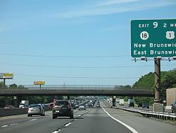
. Continuing north into more dense suburban development, I-95 intersects Route 18 in East Brunswick Township
near the city of New Brunswick
. After crossing the Raritan River, the New Jersey Turnpike heads northeast to the I-287
/Route 440 junction in Edison
. In Woodbridge Township
, the highway comes to a large interchange accessing both the Garden State Parkway
and US 9. From this point, the road enters areas of heavy industry and comes to the CR 602 exit in Carteret
. In Union County
, I-95 comes to the I-278
exit on the border of Linden
and Elizabeth
at the western approach to the Goethals Bridge
. In the northern part of Elizabeth, the New Jersey Turnpike comes to Route 81 which provides access to the Newark Liberty International Airport
before the road runs to the east of the airport. After the airport, I-95 intersects I-78
in Newark
, Essex County
. At US 1-9 Truck, the New Jersey Turnpike splits into two alignments and enters the New Jersey Meadowlands
.
The mainline of I-95 officially follows the Eastern Spur of the New Jersey Turnpike, which has exits to I-280
in Kearny
, Hudson County
and the Secaucus Junction
train station and Route 3/Route 495 in Secaucus
before reaching the end of the ticket system. The Western Spur of the New Jersey Turnpike is signed as I-95 also but officially known as Route 95W. This road has interchanges serving I-280 in Kearny and Route 3/Route 120
in East Rutherford
, Bergen County
, the latter serving the Meadowlands Sports Complex
. The ticket system on the Western Spur ends at a barrier in Carlstadt
. In Ridgefield
, the two segments of the New Jersey Turnpike merge together again, with the road continuing north into Ridgefield Park
.
, part of which was the original northern terminus of the turnpike. From this point, it has the appearance of a local-express lane
configuration carrying three local lanes and two express lanes (3-2-2-3) in each direction, but the northbound "express" lane only leads to I-80 west while the northbound local lanes continues as the main trunk of I-95. The road runs near suburban neighborhoods before entering Teaneck
and intersecting with the eastern terminus of I-80
. From here, I-95 turns northeast and splits into an actual local-express lane configuration with a 3-2-2-3 lane count, soon interchanging with CR 56 as it passes northwest of Overpeck County Park
. The highway turns east as it skirts the border between Englewood
to the north and Leonia
to the south, entering inhabited areas as it has a northbound exit and southbound entrance serving Broad Avenue. I-95 makes a turn to the southeast into Fort Lee
, and heads due south to Route 4. At this point, I-95 runs in between the travel lanes of Route 4 as the freeway comes to a large interchange with southbound exits and northbound entrances for Route 4, US 1/9
, US 46, and a full interchange with the southern terminus of US 9W
(where the Turnpike officially ends and the jurisdiction changes from the Turnpike Authority to the Port Authority
).
Here, US 1/9/46 all join I-95 and the road continues southeast containing four local lanes and four express lanes in each direction, passing numerous high-rise buildings. The road has a southbound exit and northbound entrance to Route 67 from the express lanes before coming to the eastbound-only toll plaza for the George Washington Bridge
. Past the toll plaza, there is a southbound exit and northbound entrance for the Palisades Interstate Parkway
, also from the express lanes. After the Palisades Interstate Parkway, the road crosses the Hudson River
on the George Washington Bridge, which has eight lanes total on the upper deck (the express lanes) and six lanes total on the lower deck (the local lanes).
around Trenton and then south to Hammonton
. Seven northeastern states from Virginia to Massachusetts including New Jersey proposed a limited-access highway in 1942 called the 7-State Highway; this was never built. The New Jersey State Highway Department proposed Federal Aid Interstate Route 103 in 1956, and it was approved in 1957 by the Bureau of Public Roads (BPR). At that time, the New Jersey Turnpike (main line and Pennsylvania Extension) and George Washington Bridge had been completed; US 46 connected the north end of the New Jersey Turnpike to the bridge. The BPR approved the planned alignment north of the Trenton area, which would have run generally northeast to exit 9 (Route 18) of the New Jersey Turnpike. From there it would use the New Jersey Turnpike to its north end (exit 18, US 46) and a proposed freeway north to the planned I-80, then head east to the George Washington Bridge. The road was designated as part of I-95 in 1958.
In the 1960s, the I-95 approach to the George Washington Bridge was completed, connecting to I-80 in Teaneck. The portion of I-95 between the north end of the New Jersey Turnpike and I-80 opened in 1971.
The location of I-95 in the Trenton area had not been finalized when the route was first designated. The BPR preferred using the Trenton Freeway (US 1 and Route 174), which was completed to Whitehead Road, but New Jersey and Pennsylvania proposed using the Scudder Falls Bridge
and its approach (Route 129), opened in 1961 to Scotch Road (exit 3), due in part to low design standards of the Trenton Freeway. As a result, I-95 was routed to use the Scudder Falls Bridge approach. The approach to the Scudder Falls Bridge was extended in 1974, northeast to the planned interchange with the new I-95 freeway, and then east to US 1 as I-295.
From the I-95/I-295 loop around Trenton, the free routing of I-95 in New Jersey, was to divert from the loop between the Route 31 and Federal City Road exits near the Ewing Township / Hopewell Township border. Then, the highway was to intersect CR 546 and US 206 before coming to I-287 in Piscataway. There was also meant to be a small connector roughly one mile in length connecting I-95 with I-287 from the north and designated I-695. (The I-695 designation, along with I-95's alignment in Piscataway Township, was dropped when I-695's own alignment became the preferred routing for I-95 to a full 3-way interchange with I-287 in Franklin Township
.)
At this point, the freeway would have continued northeastward through the western parts of Elizabeth and Newark, then terminate at the northern terminus of the New Jersey Turnpike at Ridgefield, but it was instead decided to route I-95 along the New Jersey Turnpike through North Jersey.
The truncated route, known as the Somerset Freeway, was intended to terminate in Piscataway Township at I-287, and I-95 would have continued east along I-287 until it intersected with the New Jersey Turnpike in Edison Township. Both the Somerset Freeway and I-695 were projected to cost $55 million in 1967, with the cost increasing to $375 million in 1979. At this point, residents in Hopewell Township, Princeton Borough
, Princeton Township
, and Montgomery Township
raised opposition out of the fear the Somerset Freeway would bring unwanted development to area farmland. The New Jersey Turnpike Authority
joined environmental and community groups in opposing the Somerset Freeway, as it would provide a toll-free alternative to the New Jersey Turnpike. Due to this opposition, New Jersey Governor Brendan Byrne
announced in 1980 that the state would not build the Somerset Freeway. The United States Senate
officially cancelled the Somerset Freeway in 1983. As a result of this cancellation, the federal government gave New Jersey $246 million for road projects in the area where the Somerset Freeway was to be built.
The New Jersey Department of Transportation transferred the section of I-95 between the north end of the New Jersey Turnpike and the George Washington Bridge to the New Jersey Turnpike Authority in 1992 in order to balance the state budget, thus incorporating it as part of the mainline Turnpike.
In 1995, increasing truck traffic on US 206 and Route 31 motivated officials in Mercer County to have the state reconsider building the Somerset Freeway as a way to alleviate traffic on area roads. This option was ruled out due to a $700 million price tag. Also around this time, I-95 was extended east along I-295 between the site of the Somerset Freeway interchange and US 1 in Lawrence Township. Also, the road was officially extended down the New Jersey Turnpike and Pennsylvania Extension to the Delaware River-Turnpike Toll Bridge.
). Southbound I-95 traffic headed to Delaware
is directed to continue south on the New Jersey Turnpike and use the Delaware Memorial Bridge
. The same is done in reverse: thru traffic on I-95 near Wilmington, Delaware
is pointed to New Jersey and New York City via the Delaware Memorial Bridge and the New Jersey Turnpike. Meanwhile, traffic from Pennsylvania and Trenton is directed via I-295 and I-195.
In order to close this gap in I-95, an interchange
is planned between I-95 and the Pennsylvania Turnpike in Bristol Township, Pennsylvania
. The interchange was first planned in the 1980s after the Somerset Freeway was cancelled, making I-95 discontinuous. As a result of this project, I-95 will be rerouted from its current alignment in Pennsylvania at the interchange to the easternmost part of the Pennsylvania Turnpike, replacing I-276 between the interchange and the Delaware River at the Delaware River-Turnpike Toll Bridge. In addition, I-195 will be extended westward from its current western terminus and around the north side of Trenton on present-day I-295 and I-95 to the new interchange. Originally, I-295 was to be extended around Trenton on the current I-95 to the new interchange, but I-195 was chosen instead. Construction on the interchange is expected to start in 2010 with completion in 2017.
.
{| class="wikitable" border="1"
|-
!Location
!Mile
!Exit
!Destinations
!Notes
|-
|rowspan="3"|Ewing Township
|0.00
|colspan=3 align=center|Scudder Falls Bridge
over Delaware River
|-
|0.07
|1
|
|
|-
|1.56
|2
| Passenger Terminal
|
|-
|rowspan="2"|Hopewell Township
|2.83
|3
| General Aviation
|Split into exits 3A and 3B northbound
|-
|4.24
|4
|
|
|-
|rowspan="4"|Lawrence Township
|5.64
|5
|Federal City Road
|Southbound exit and northbound entrance; split into exits 5A and 5B
|-
|7.11
|7
|
|Split into exits 7A and 7B
|-
|8.12
|8
|
|Split into exits 8A and 8B; northbound exit 8A is CR 546
east to CR 583
south
|-
|8.77
|
|
|Northern terminus of Trenton segment of I-95
|-
!County
!Location
!Mile
!Exit
!Destinations
!Notes
|-
|rowspan="6"|Burlington
|rowspan="2"|Burlington Township
|rowspan="2"|0.00
|
|
|Continuation into Pennsylvania
|-
|colspan=3 align=center|Delaware River-Turnpike Toll Bridge
over Delaware River
|-
|rowspan=2|Florence Township
|2.61
|
|
|Toll plaza at southbound entrance
|-
|3.17
|colspan=3 align=center|NJ Turnpike Exit 6 Toll Plaza (Pennsylvania Turnpike
)
|-
|Mansfield Township
|5.33-6.50
|6
|, Delaware
|South end of overlap with NJ Turnpike mainline
|-
|Bordentown Township
|7.95
|7
|
|
|-
|rowspan=2|Mercer
|Robbinsville Township
|15.15
|7A
|
|
|-
|East Windsor Township
|22.21
|8
|
|
|-
|rowspan=6|Middlesex
|Cranbury Township
|27.40
|
|colspan=2 align="center"|Turnpike divides northbound and merges southbound
(Inner roadway for cars only, outer roadway for cars-trucks-buses.)
|-
|Monroe Township
|28.51
|8A
|, Monroe
|
|-
|East Brunswick Township
|38.07
|9
|
|
|-
|Edison Township
|42.73
|10
|
|
|-
|Woodbridge Township
|45.65
|11
|
|
|-
|Carteret
|50.53
|12
|
|
|-
|rowspan=2|Union
|rowspan=2|Elizabeth
|53.75
|13
|, Verrazano Bridge
|
|-
|56.33
|13A
|
|
|-
|rowspan=3|Essex
|rowspan=3|Newark
|59.19
|14
|
|
|-
|61.10-61.30
|
|colspan=2 align="center"|Car and truck lanes end northbound and begin southbound.
Eastern and Western Spurs (continuations of the car and truck lanes, respectively) begin northbound and end southbound.
|-
|E61.52
W1.15-1.26
|15E
|
|Full interchange on the Eastern Spur, southbound exit and northbound entrance on the Western Spur
|-
|rowspan=4|Hudson
|Kearny
|E63.18
W3.08
|15W
|
|Full interchange on the Western Spur, southbound exit and northbound entrance on the Eastern Spur
|-
|rowspan=3|Town of Secaucus
|E65.30
|15X
|Secaucus Junction
, Secaucus
|Exit on the Eastern Spur
|-
|E67.23
|16E
18E
|colspan=2 align="center"|NJ Turnpike Exit 16E/18E Toll Plaza (Lincoln Tunnel
/George Washington Bridge
)
|-
|E67.60
|17
|
|Exit on the Eastern Spur. Signed as Exit 16E northbound; northbound entrance is toll-free.
|-
|rowspan=16|Bergen
|East Rutherford
|W7.02
|16W
|
|Exit on the Western Spur
|-
|Carlstadt
|W8.00-8.10
|18W
|colspan=2 align="center"|NJ Turnpike Exit 18W Toll Plaza (George Washington Bridge
)
|-
|rowspan=3|Ridgefield Park
|E71.32-71.41
W11.03
|
|align="center" colspan=2|Eastern and Western Spurs merge northbound and split southbound.
|-
|72.31
|rowspan=2|68
|
|Exit number only signed southbound
|-
|72.48
|Challenger Road
|Northbound exit only; southbound exit is part of exit 68 (US 46)
|-
|colspan=6 align=center|Express (upper) lanes and local (lower) lanes split northbound and merge southbound.
|-
|rowspan="2"|Teaneck
|73.59
|69
|
|Exit number only signed southbound; east end of I-80.
|-
|74.10
|70
|
|Signed as exits 70A (Leonia) and 70B (Teaneck) northbound
|-
|Englewood
|75.58
|71
|Broad Avenue – Leonia
, Englewood
|Northbound exit and southbound entrance
|-
|rowspan="7"|Fort Lee
|76.2-76.53
|72A
|
|East end of Route 4; southbound exit and northbound entrance
|-
|76.62-76.66
|72B
|
|South end of US 1/9/46 overlap; southbound exit and northbound entrance
|-
|77.02
|72
|
|Signed as exit 73-74 southbound
North end of NJ Turnpike
|-
|77.18
|73
|
|Southbound exit and northbound entrance (express lanes only)
|-
|77.53
|74
|
|Southbound exit and northbound entrance (express lanes only)
|-
|rowspan="2"|77.96
|colspan=2 align=center|George Washington Bridge
over Hudson River
|East end of US 46
|-
|
|
|Continuation into New York
East Coast of the United States
The East Coast of the United States, also known as the Eastern Seaboard, refers to the easternmost coastal states in the United States, which touch the Atlantic Ocean and stretch up to Canada. The term includes the U.S...
of the United States
United States
The United States of America is a federal constitutional republic comprising fifty states and a federal district...
, from Florida
Florida
Florida is a state in the southeastern United States, located on the nation's Atlantic and Gulf coasts. It is bordered to the west by the Gulf of Mexico, to the north by Alabama and Georgia and to the east by the Atlantic Ocean. With a population of 18,801,310 as measured by the 2010 census, it...
to Maine
Maine
Maine is a state in the New England region of the northeastern United States, bordered by the Atlantic Ocean to the east and south, New Hampshire to the west, and the Canadian provinces of Quebec to the northwest and New Brunswick to the northeast. Maine is both the northernmost and easternmost...
. In the state of New Jersey
New Jersey
New Jersey is a state in the Northeastern and Middle Atlantic regions of the United States. , its population was 8,791,894. It is bordered on the north and east by the state of New York, on the southeast and south by the Atlantic Ocean, on the west by Pennsylvania and on the southwest by Delaware...
, it runs along much of the main line of the New Jersey Turnpike
New Jersey Turnpike
The New Jersey Turnpike is a toll road in New Jersey, maintained by the New Jersey Turnpike Authority. According to the International Bridge, Tunnel and Turnpike Association, the Turnpike is the nation's sixth-busiest toll road and is among one of the most heavily traveled highways in the United...
, as well as the Pearl Harbor Memorial Extension (formerly known as the Pennsylvania Turnpike
Pennsylvania Turnpike
The Pennsylvania Turnpike is a toll highway system operated by the Pennsylvania Turnpike Commission in the Commonwealth of Pennsylvania, United States. The three sections of the turnpike system total . The main section extends from Ohio to New Jersey and is long...
Connector) and the New Jersey Turnpike's northern continuation to the George Washington Bridge
George Washington Bridge
The George Washington Bridge is a suspension bridge spanning the Hudson River, connecting the Washington Heights neighborhood in the borough of Manhattan in New York City to Fort Lee, Bergen County, New Jersey. Interstate 95 and U.S. Route 1/9 cross the river via the bridge. U.S...
, also maintained by the New Jersey Turnpike Authority
New Jersey Turnpike Authority
The New Jersey Turnpike Authority is a state agency responsible for maintaining the New Jersey Turnpike and the Garden State Parkway...
, for a total of 77.96 mi (125.46 km). Located in the northeastern part of the state near New York City
New York City
New York is the most populous city in the United States and the center of the New York Metropolitan Area, one of the most populous metropolitan areas in the world. New York exerts a significant impact upon global commerce, finance, media, art, fashion, research, technology, education, and...
, the 11.03 miles (17.75 km) Western Spur of the New Jersey Turnpike, considered to be Route 95W by the New Jersey Department of Transportation
New Jersey Department of Transportation
The New Jersey Department of Transportation is the agency responsible for transportation issues and policy in New Jersey. It is headed by the Commissioner of Transportation...
, is also part of I-95. There is also a segment of I-95 to the north of Trenton
Trenton, New Jersey
Trenton is the capital of the U.S. state of New Jersey and the county seat of Mercer County. As of the 2010 United States Census, Trenton had a population of 84,913...
that is 8.77 mi (14.11 km) and connects the Scudder Falls Bridge
Scudder Falls Bridge
The Scudder Falls Bridge is a girder bridge that carries Interstate 95 over the Delaware River, connecting Lower Makefield Township in Bucks County, Pennsylvania with Ewing Township in Mercer County, New Jersey. This bridge, which was constructed from 1958 to 1959, is maintained by the Delaware...
to I-295
Interstate 295 (Delaware-New Jersey)
Interstate 295 in New Jersey and Delaware is an auxiliary Interstate Highway, designated as a bypass around Philadelphia, Pennsylvania. The route begins at a junction with Interstate 95 south of Wilmington, Delaware, and runs to another junction with I-95 north of Trenton, New Jersey...
and U.S. Route 1
U.S. Route 1 in New Jersey
U.S. Route 1 is a United States highway which parallels the East Coast of the United States, running from Key West, Florida in the south to Fort Kent, Maine at the Canadian border in the north. Of the entire length of the route, of it runs through New Jersey...
(US 1); this is officially Route 95M.
I-95 is discontinuous within New Jersey. From the Pennsylvania
Pennsylvania
The Commonwealth of Pennsylvania is a U.S. state that is located in the Northeastern and Mid-Atlantic regions of the United States. The state borders Delaware and Maryland to the south, West Virginia to the southwest, Ohio to the west, New York and Ontario, Canada, to the north, and New Jersey to...
direction, I-95 enters New Jersey on the Scudder Falls Bridge and halts at the US 1 interchange, where the freeway turns south as I-295. From the New York
New York
New York is a state in the Northeastern region of the United States. It is the nation's third most populous state. New York is bordered by New Jersey and Pennsylvania to the south, and by Connecticut, Massachusetts and Vermont to the east...
direction, I-95 enters New Jersey from the George Washington Bridge and continues south on the New Jersey Turnpike and Pearl Harbor Memorial Extension, where it becomes I-276 at the Delaware River-Turnpike Toll Bridge
Delaware River-Turnpike Toll Bridge
The Delaware River – Turnpike Toll Bridge is a four-lane steel arch-shaped suspended deck truss bridge that connects the Pennsylvania Turnpike's East-West Mainline with the main trunk of the New Jersey Turnpike, via the Pearl Harbor Memorial Extension...
into Pennsylvania. This discontinuation was caused by the cancellation of the Somerset Freeway in 1983, which would have run from the Trenton segment of I-95 in Hopewell Township
Hopewell Township, Mercer County, New Jersey
As of the 2010 United States Census, the township's population was 17,304. The racial makeup of the township was 86.7% White, 2.1% African American, 0.1% Native American, 8.9% Asian, 0.0% Pacific Islander, 0.5% from other races, and 1.7% from two or more races...
northeast to I-287
Interstate 287
Interstate 287 is an auxiliary Interstate Highway in the U.S. states of New Jersey and New York. It is a partial beltway around New York City, serving the northern half of New Jersey and the counties of Rockland and Westchester in New York...
in Piscataway Township
Piscataway Township, New Jersey
The township consists of the following historic villages and areas: New Market, known as Quibbletown in the 18th Century, Randolphville, Fieldville and North Stelton...
. Here, I-95 would follow present-day I-287 to the New Jersey Turnpike in Edison
Edison, New Jersey
Edison Township is a township in Middlesex County, New Jersey. What is now Edison Township was originally incorporated as Raritan Township by an Act of the New Jersey Legislature on March 17, 1870, from portions of both Piscataway Township and Woodbridge Township...
. In order to fill the gap, the Pennsylvania Turnpike/Interstate 95 Interchange Project
Pennsylvania Turnpike/Interstate 95 Interchange Project
The Pennsylvania Turnpike/Interstate 95 Interchange Project is a project to build an interchange where Interstate 95 crosses the Pennsylvania Turnpike in Bristol Township, Pennsylvania. This will fill the gap that exists on I-95 through New Jersey due to the cancellation of the Somerset Freeway....
has started construction of an interchange between the Pennsylvania Turnpike
Pennsylvania Turnpike
The Pennsylvania Turnpike is a toll highway system operated by the Pennsylvania Turnpike Commission in the Commonwealth of Pennsylvania, United States. The three sections of the turnpike system total . The main section extends from Ohio to New Jersey and is long...
and I-95 in Bristol Township, Pennsylvania
Bristol Township, Pennsylvania
Bristol Township is a township in Bucks County, Pennsylvania, United States. The population was 54,582 at the 2010 census, making it the 13th largest municipality in the state. Bristol Township, along with Bristol Borough, is a cultural hub for Lower Bucks County, hosting celebrations of African...
, with I-95 being rerouted to use the Pennsylvania Turnpike to the Delaware River-Turnpike Toll Bridge. The current I-95 and I-295 around the north side of Trenton will become an extension of I-195
Interstate 195 (New Jersey)
Interstate 195 is an auxiliary route of the Interstate Highway System located in the U.S. state of New Jersey. Its western end is at I-295 and Route 29 just south of Trenton, New Jersey in Hamilton Township, Mercer County while its eastern end is at the Garden State Parkway, Route 34 and Route...
. This interchange is expected to open in 2015.
Trenton segment
The New Jersey segment of I-95 north of TrentonTrenton, New Jersey
Trenton is the capital of the U.S. state of New Jersey and the county seat of Mercer County. As of the 2010 United States Census, Trenton had a population of 84,913...
, officially numbered as Route 95M by the New Jersey Department of Transportation
New Jersey Department of Transportation
The New Jersey Department of Transportation is the agency responsible for transportation issues and policy in New Jersey. It is headed by the Commissioner of Transportation...
, begins at the Scudder Falls Bridge
Scudder Falls Bridge
The Scudder Falls Bridge is a girder bridge that carries Interstate 95 over the Delaware River, connecting Lower Makefield Township in Bucks County, Pennsylvania with Ewing Township in Mercer County, New Jersey. This bridge, which was constructed from 1958 to 1959, is maintained by the Delaware...
over the Delaware River
Delaware River
The Delaware River is a major river on the Atlantic coast of the United States.A Dutch expedition led by Henry Hudson in 1609 first mapped the river. The river was christened the South River in the New Netherland colony that followed, in contrast to the North River, as the Hudson River was then...
in Ewing Township
Ewing Township, New Jersey
-Demographics:As of the 2010 Census, there were 35,790 people, 13,171 households, and 7,980 families residing in the township. There were 13,926 housing units. The racial makeup of the township was 63.1% White, 27.6% African American, 0.3% Native American, 4.3% Asian, 0.0% Pacific Islander, 2.2%...
, Mercer County
Mercer County, New Jersey
As of the census of 2000, there were 350,761 people, 125,807 households, and 86,303 families residing in the county. The population density was 1,552 people per square mile . There were 133,280 housing units at an average density of 590 per square mile...
. This bridge is four-lanes wide and is maintained by the Delaware River Joint Toll Bridge Commission
Delaware River Joint Toll Bridge Commission
The Delaware River Joint Toll Bridge Commission is a bistate, public agency charged with providing safe, dependable and efficient river crossings between Pennsylvania and New Jersey. The DRJTBC was established under legislation enacted in the two states in 1934. The federal Compact for the...
. From this point, I-95 continues south into Bucks County, Pennsylvania
Bucks County, Pennsylvania
- Industry and commerce :The boroughs of Bristol and Morrisville were prominent industrial centers along the Northeast Corridor during World War II. Suburban development accelerated in Lower Bucks in the 1950s with the opening of Levittown, Pennsylvania, the second such "Levittown" designed by...
. Immediately after the river, the freeway comes to the Route 29 interchange that also has a northbound entrance from Route 175. Past this interchange, I-95 becomes maintained by the New Jersey Department of Transportation and widens to six lanes, heading northeast past suburban development containing some farmland. The next interchange along the route provides access to CR 579
County Route 579 (New Jersey)
County Route 579, abbreviated CR 579, is a county highway in the U.S. state of New Jersey. The highway extends from John Fitch Parkway in Trenton to Route 173 in Greenwich Township.-Mercer County:...
and the Trenton-Mercer Airport
Trenton-Mercer Airport
Trenton-Mercer Airport , formerly known as Mercer County Airport, is a public airport located in Ewing, New Jersey, four miles northwest of the central business district of Trenton, a city in Mercer County, New Jersey...
. After CR 579, the highway passes to the northwest of the airport before coming into Hopewell Township
Hopewell Township, Mercer County, New Jersey
As of the 2010 United States Census, the township's population was 17,304. The racial makeup of the township was 86.7% White, 2.1% African American, 0.1% Native American, 8.9% Asian, 0.0% Pacific Islander, 0.5% from other races, and 1.7% from two or more races...
. A cloverleaf interchange
Cloverleaf interchange
A cloverleaf interchange is a two-level interchange in which left turns, reverse direction in left-driving regions, are handled by ramp roads...
with CR 611 also serves the Trenton-Mercer Airport. I-95 turns east, passing through Ewing Township again before coming back into Hopewell Township and reaching the Route 31 interchange.
The median of the freeway widens as it runs near suburban residential areas and comes into Lawrence Township
Lawrence Township, Mercer County, New Jersey
Area residents often refer to all of Lawrence Township as Lawrenceville. Lawrenceville is a census-designated place and unincorporated area located within Lawrence Township...
. This is where the Somerset Freeway would have begun had it been built. Upon entering Lawrence Township, the median narrows and I-95 has a southbound exit and northbound entrance serving Federal City Road. Continuing east, the road reaches a cloverleaf interchange with US 206
U.S. Route 206
U.S. Route 206 is a long north–south United States highway in New Jersey and Pennsylvania, United States. Only about a half a mile of its length is in Pennsylvania; the Milford-Montague Toll Bridge carries it over the Delaware River into New Jersey, where it is the remainder of the route...
. After US 206, I-95 comes to a northbound ramp to CR 546
County Route 546 (New Jersey)
County Route 546, abbreviated CR 546, is a county highway in the U.S. state of New Jersey. The highway begins at the Washington Crossing Bridge at Titusville, New Jersey and extends from Route 29 in Hopewell Township to U.S...
before coming to a partial cloverleaf interchange at CR 583
County Route 583 (New Jersey)
County Route 583, abbreviated CR 583, is a county highway in the U.S. state of New Jersey. Its northern end is at an intersection with Route 27 in Princeton; its southern end is in a concurrency with U.S. Route 1 Business and U.S...
. From this point, the freeway passes commercial areas before reaching a cloverleaf interchange at US 1
U.S. Route 1 in New Jersey
U.S. Route 1 is a United States highway which parallels the East Coast of the United States, running from Key West, Florida in the south to Fort Kent, Maine at the Canadian border in the north. Of the entire length of the route, of it runs through New Jersey...
. This segment of I-95 ends just west of the US 1 interchange and the freeway turns south as I-295
Interstate 295 (Delaware-New Jersey)
Interstate 295 in New Jersey and Delaware is an auxiliary Interstate Highway, designated as a bypass around Philadelphia, Pennsylvania. The route begins at a junction with Interstate 95 south of Wilmington, Delaware, and runs to another junction with I-95 north of Trenton, New Jersey...
, where motorists use I-295 south and I-195
Interstate 195 (New Jersey)
Interstate 195 is an auxiliary route of the Interstate Highway System located in the U.S. state of New Jersey. Its western end is at I-295 and Route 29 just south of Trenton, New Jersey in Hamilton Township, Mercer County while its eastern end is at the Garden State Parkway, Route 34 and Route...
east to access the New Jersey Turnpike
New Jersey Turnpike
The New Jersey Turnpike is a toll road in New Jersey, maintained by the New Jersey Turnpike Authority. According to the International Bridge, Tunnel and Turnpike Association, the Turnpike is the nation's sixth-busiest toll road and is among one of the most heavily traveled highways in the United...
and the main segment of I-95 in New Jersey.
New Jersey Turnpike
The main segment of I-95 in New Jersey officially begins at the Delaware River-Turnpike Toll BridgeDelaware River-Turnpike Toll Bridge
The Delaware River – Turnpike Toll Bridge is a four-lane steel arch-shaped suspended deck truss bridge that connects the Pennsylvania Turnpike's East-West Mainline with the main trunk of the New Jersey Turnpike, via the Pearl Harbor Memorial Extension...
over the Delaware River in Burlington Township
Burlington Township, New Jersey
- Local government :Burlington Township is governed under the Faulkner Act Plan E form of municipal government and consists of a mayor and a seven-member Township Council. The council is elected at-large in partisan elections to four-year terms in office on a staggered basis., the Mayor of...
, Burlington County
Burlington County, New Jersey
There were 154,371 households out of which 34.30% had children under the age of 18 living with them, 57.70% were married couples living together, 10.90% had a female householder with no husband present, and 27.70% were non-families. 22.90% of all households were made up of individuals and 8.50% had...
, where the road continues west into Pennsylvania as the Pennsylvania Turnpike
Pennsylvania Turnpike
The Pennsylvania Turnpike is a toll highway system operated by the Pennsylvania Turnpike Commission in the Commonwealth of Pennsylvania, United States. The three sections of the turnpike system total . The main section extends from Ohio to New Jersey and is long...
(I-276). From the river, I-95 follows the six-lane Pearl Harbor Memorial Extension of the New Jersey Turnpike east into New Jersey. This road, which is maintained by the New Jersey Turnpike Authority
New Jersey Turnpike Authority
The New Jersey Turnpike Authority is a state agency responsible for maintaining the New Jersey Turnpike and the Garden State Parkway...
, is not signed as part of I-95 but rather as the New Jersey Turnpike or as I-276 from the mainline New Jersey Turnpike. Continuing east through rural areas into Florence Township
Florence Township, New Jersey
-Demographics:As of the census of 2000, there were 10,746 people, 4,149 households, and 2,891 families residing in the township. The population density was 1,106.5 people per square mile . There were 4,391 housing units at an average density of 452.1 per square mile...
, the highway has an interchange serving US 130
U.S. Route 130
U.S. Route 130 is a north–south U.S. Highway completely within the state of New Jersey. It runs from Interstate 295 and US 40 at Deepwater in Pennsville Township, Salem County, where the road continues east as Route 49, north to US 1 in North Brunswick Township, Middlesex County, where...
. This interchange has a toll plaza on the ramp to southbound I-95. After this interchange, the road comes to a toll barrier that marks the beginning of the turnpike ticket system northbound and the end of the ticket system southbound. The Pearl Harbor Memorial Extension crosses into Mansfield Township
Mansfield Township, Burlington County, New Jersey
-Demographics:As of the census of 2000, there were 5,090 people, 2,077 households, and 1,561 families residing in the township. The population density was 234.3 people per square mile . There were 2,122 housing units at an average density of 97.7 per square mile...
and crosses under I-295 before merging into the mainline of the New Jersey Turnpike at exit 6.
Bordentown Township, New Jersey
Of note, the Crosswicks Creek and its juncture with the Delaware River, otherwise known as the Trenton-Hamilton Marsh, is a very significant ecosystem and, with the peninsula of land and waterways to the northwest of Bordentown Township known, respectively, as Duck Island, Duck Creek and the...
. Continuing north through mostly rural areas, the road heads into Mercer County and comes to the I-195 interchange in Robbinsville Township. At I-195, the New Jersey Turnpike becomes signed as part of I-95. In East Windsor Township
East Windsor Township, New Jersey
-Demographics:As of the census of 2000, there were 24,919 people, 9,448 households, and 6,556 families residing in the township. The population density was 1,592.8 people per square mile . There were 9,880 housing units at an average density of 631.5 per square mile...
, the road comes to the Route 33 interchange, located to the east of Hightstown
Hightstown, New Jersey
Hightstown is a Borough in Mercer County, New Jersey, United States. As of the 2010 United States Census, the borough population was 5,494.Hightstown was incorporated as a borough by an Act of the New Jersey Legislature on March 5, 1853, within portions of East Windsor Township. The borough became...
. Heading into Middlesex County
Middlesex County, New Jersey
-Demographics:As of the census of 2000, there were 750,162 people, 265,815 households, and 190,855 families residing in the county. The population density was 2,422 people per square mile . There were 273,637 housing units at an average density of 884 per square mile...
, development near the highway increases as the road widens into separate lanes for cars and for cars, trucks, and buses. At this point, an interchange serves Route 32 in Monroe Township
Monroe Township, Middlesex County, New Jersey
Monroe Township is a Township in Middlesex County, New Jersey, United States. As of the United States 2000 Census, the township population was 27,999. Monroe was incorporated as a township by an Act of the New Jersey Legislature on April 9, 1838, from portions of South Amboy Township, based on the...
. Continuing north into more dense suburban development, I-95 intersects Route 18 in East Brunswick Township
East Brunswick Township, New Jersey
The town is located southwest of New York City and 48 miles northeast of Philadelphia.Lawrence Brook, a tributary of the Raritan River, runs along the western border of the township...
near the city of New Brunswick
New Brunswick, New Jersey
New Brunswick is a city in Middlesex County, New Jersey, USA. It is the county seat and the home of Rutgers University. The city is located on the Northeast Corridor rail line, southwest of Manhattan, on the southern bank of the Raritan River. At the 2010 United States Census, the population of...
. After crossing the Raritan River, the New Jersey Turnpike heads northeast to the I-287
Interstate 287
Interstate 287 is an auxiliary Interstate Highway in the U.S. states of New Jersey and New York. It is a partial beltway around New York City, serving the northern half of New Jersey and the counties of Rockland and Westchester in New York...
/Route 440 junction in Edison
Edison, New Jersey
Edison Township is a township in Middlesex County, New Jersey. What is now Edison Township was originally incorporated as Raritan Township by an Act of the New Jersey Legislature on March 17, 1870, from portions of both Piscataway Township and Woodbridge Township...
. In Woodbridge Township
Woodbridge Township, New Jersey
-Communities:Many distinct communities exist within Woodbridge Township. Several of these communities have their own ZIP codes, and many are listed by the United States Census Bureau as census-designated places, but they are all unincorporated areas and neighborhoods within the Township that,...
, the highway comes to a large interchange accessing both the Garden State Parkway
Garden State Parkway
The Garden State Parkway is a 172.4-mile limited-access toll parkway that stretches the length of New Jersey from the New York line at Montvale, New Jersey, to Cape May at New Jersey's southernmost tip. Its name refers to New Jersey's nickname, the "Garden State." Most New Jersey residents refer...
and US 9. From this point, the road enters areas of heavy industry and comes to the CR 602 exit in Carteret
Carteret, New Jersey
Carteret is a borough in Middlesex County, New Jersey, United States. As of the 2010 United States Census, the borough population was 22,844.Carteret was created as the borough of Roosevelt on 11 April 1906, incorporating Woodbridge Township, and was a result of a referendum on 22 May 1906...
. In Union County
Union County, New Jersey
Union County is a county located in the U.S. state of New Jersey. As of the 2010 Census, the population was 536,499. It is part of the New York Metropolitan Area. Its county seat is Elizabeth. Union County ranks 93rd among the highest-income counties in the United States. It also ranks 74th in...
, I-95 comes to the I-278
Interstate 278
Interstate 278 is an auxiliary Interstate Highway in New Jersey and New York, United States. The road runs from U.S. Route 1/9 in Linden, New Jersey to the Bruckner Interchange in the New York City borough of the Bronx...
exit on the border of Linden
Linden, New Jersey
- Local government :, the Mayor of Linden is . The former longtime Mayor of Linden is 82-year-old John T. Gregorio, who served as mayor of Linden for 30, nonconsecutive years and was repeatedly tagged with scandal during his mayoral career, including one felony conviction, later pardoned, which...
and Elizabeth
Elizabeth, New Jersey
Elizabeth is a city in Union County, New Jersey, United States. As of the 2010 United States Census, the city had a total population of 124,969, retaining its ranking as New Jersey's fourth largest city with an increase of 4,401 residents from its 2000 Census population of 120,568...
at the western approach to the Goethals Bridge
Goethals Bridge
The Goethals Bridge connects Elizabeth, New Jersey to Staten Island , near the Howland Hook Marine Terminal, Staten Island, New York over the Arthur Kill. Operated by the Port Authority of New York and New Jersey, the span was one of the first structures built by the authority...
. In the northern part of Elizabeth, the New Jersey Turnpike comes to Route 81 which provides access to the Newark Liberty International Airport
Newark Liberty International Airport
Newark Liberty International Airport , first named Newark Metropolitan Airport and later Newark International Airport, is an international airport within the city limits of both Newark and Elizabeth, New Jersey, United States...
before the road runs to the east of the airport. After the airport, I-95 intersects I-78
Interstate 78 in New Jersey
Interstate 78 is an east–west route stretching from Union Township, Lebanon County, Pennsylvania to New York City. In New Jersey, I-78 is called the Phillipsburg–Newark Expressway and the Newark Bay Extension of the New Jersey Turnpike...
in Newark
Newark, New Jersey
Newark is the largest city in the American state of New Jersey, and the seat of Essex County. As of the 2010 United States Census, Newark had a population of 277,140, maintaining its status as the largest municipality in New Jersey. It is the 68th largest city in the U.S...
, Essex County
Essex County, New Jersey
Essex County is a county located in the northeastern part of the U.S. state of New Jersey. As of the United States 2010 Census, the population was 783,969, ranking it third in the state after Bergen County and Middlesex County; Essex County's population has declined from 786,147 as of the bureau's...
. At US 1-9 Truck, the New Jersey Turnpike splits into two alignments and enters the New Jersey Meadowlands
New Jersey Meadowlands
New Jersey Meadowlands, also known as the Hackensack Meadowlands after the primary river flowing through it, is a general name for the large ecosystem of wetlands in northeast New Jersey in the United States. The Meadowlands are known for being the site of large landfills and decades of...
.
The mainline of I-95 officially follows the Eastern Spur of the New Jersey Turnpike, which has exits to I-280
Interstate 280 (New Jersey)
Interstate 280 is a Interstate Highway in the U.S. state of New Jersey. It provides a spur from I-80 in Parsippany-Troy Hills, Morris County to Newark, and I-95 Interstate 280 (abbreviated I-280) is a Interstate Highway in the U.S. state of New Jersey. It provides a spur from I-80 in...
in Kearny
Kearny, New Jersey
Kearny is a town in Hudson County, New Jersey, United States. It was named after Civil War general Philip Kearny. As of the United States 2010 Census, the town population was 40,684. The town is a suburb of the nearby city of Newark....
, Hudson County
Hudson County, New Jersey
Hudson County is the smallest county in New Jersey and one of the most densely populated in United States. It takes its name from the Hudson River, which creates part of its eastern border. Part of the New York metropolitan area, its county seat and largest city is Jersey City.- Municipalities...
and the Secaucus Junction
Secaucus Junction
The Frank R. Lautenberg Secaucus Junction Station is a major commuter rail hub in Secaucus, New Jersey...
train station and Route 3/Route 495 in Secaucus
Secaucus, New Jersey
Secaucus is a town in Hudson County, New Jersey. As of the 2010 United States Census, the town population was 16,264. Located within the New Jersey Meadowlands, it is the most suburban of the county's municipalities, though large parts of the town are dedicated to light manufacturing, retail, and...
before reaching the end of the ticket system. The Western Spur of the New Jersey Turnpike is signed as I-95 also but officially known as Route 95W. This road has interchanges serving I-280 in Kearny and Route 3/Route 120
New Jersey Route 120
Route 120 is a state highway located in Bergen County, New Jersey, United States. It extends from an interchange with Route 3 in East Rutherford to another interchange with Route 17 in Carlstadt, where it continues to the west as County Route 120. NJ 120 serves the Meadowlands Sports Complex,...
in East Rutherford
East Rutherford, New Jersey
East Rutherford is a borough in Bergen County, New Jersey. As of the 2010 United States Census, the borough population was 8,913. It is an inner-ring suburb of New York City, located west of Midtown Manhattan....
, Bergen County
Bergen County, New Jersey
Bergen County is the most populous county of the state of New Jersey, United States. As of the 2010 United States Census, its population was 905,116. The county is part of the New York City Metropolitan Area. Its county seat is Hackensack...
, the latter serving the Meadowlands Sports Complex
Meadowlands Sports Complex
The MetLife Sports Complex is a sports and entertainment facility located in East Rutherford, Bergen County, New Jersey, United States, owned and operated by the New Jersey Sports and Exposition Authority...
. The ticket system on the Western Spur ends at a barrier in Carlstadt
Carlstadt, New Jersey
Carlstadt is a borough in Bergen County, New Jersey, United States. As of the 2010 United States Census, the borough population was 6,127.Carlstadt was originally formed as a village by an Act of the New Jersey Legislature on March 12, 1860, within Lodi Township. It was named after Dr...
. In Ridgefield
Ridgefield, New Jersey
There were 4,020 households out of which 32.1% had children under the age of 18 living with them, 59.7% were married couples living together, 9.9% had a female householder with no husband present, and 26.2% were non-families. 23.0% of all households were made up of individuals and 11.8% had someone...
, the two segments of the New Jersey Turnpike merge together again, with the road continuing north into Ridgefield Park
Ridgefield Park, New Jersey
Ridgefield Park is a village in Bergen County, New Jersey, United States. The population was 12,729 at the 2010 United States Census. Of 566 municipalities statewide, Ridgefield Park is only one of three with a village type of government in New Jersey, along with Loch Arbour and Ridgewood.The...
.
George Washington Bridge approach
In Ridgefield Park, I-95 continues north as a toll-free highway co-signed with the New Jersey Turnpike and maintained by the New Jersey Turnpike Authority. It has a large interchange serving US 46U.S. Route 46
U.S. Route 46 is an east–west U.S. Highway, running for , completely within the state of New Jersey. The west end is at an interchange with Interstate 80 and Route 94 in Columbia, Warren County on the Delaware River...
, part of which was the original northern terminus of the turnpike. From this point, it has the appearance of a local-express lane
Local-express lanes
A Local-express lane system is an arrangement of roadways within a major highway providing one of more roadways for express lanes with a limited number of entrances and exits and also separate roadways for local or collector lanes which provide access to all interchanges...
configuration carrying three local lanes and two express lanes (3-2-2-3) in each direction, but the northbound "express" lane only leads to I-80 west while the northbound local lanes continues as the main trunk of I-95. The road runs near suburban neighborhoods before entering Teaneck
Teaneck, New Jersey
Teaneck is a township in Bergen County, New Jersey, and a suburb in the New York metropolitan area. As of the 2010 United States Census, the township population was 39,776, making it the second-most populous among the 70 municipalities in Bergen County....
and intersecting with the eastern terminus of I-80
Interstate 80 in New Jersey
Interstate 80 is a major Interstate Highway in the United States, running from the New York City Metropolitan Area westward to San Francisco, California...
. From here, I-95 turns northeast and splits into an actual local-express lane configuration with a 3-2-2-3 lane count, soon interchanging with CR 56 as it passes northwest of Overpeck County Park
Overpeck County Park
Overpeck County Park is an county park in Bergen County, New Jersey, with major sections in Leonia, Palisades Park, Ridgefield Park, and Teaneck, surrounding Overpeck Creek, a tributary of the Hackensack River....
. The highway turns east as it skirts the border between Englewood
Englewood, New Jersey
Englewood is a city located in Bergen County, New Jersey. As of the 2010 United States Census, the city had a total population of 27,147.Englewood was incorporated as a city by an Act of the New Jersey Legislature on March 17, 1899, from portions of Ridgefield Township and the remaining portions of...
to the north and Leonia
Leonia, New Jersey
Leonia is a borough in Bergen County, New Jersey, United States. As of the 2010 United States Census, the borough population was 8,937. It is located near the western approach to the George Washington Bridge....
to the south, entering inhabited areas as it has a northbound exit and southbound entrance serving Broad Avenue. I-95 makes a turn to the southeast into Fort Lee
Fort Lee, New Jersey
Fort Lee is a borough in Bergen County, New Jersey, United States. As of the 2010 United States Census, the borough population was 35,345. Located atop the Hudson Palisades, the borough is the western terminus of the George Washington Bridge...
, and heads due south to Route 4. At this point, I-95 runs in between the travel lanes of Route 4 as the freeway comes to a large interchange with southbound exits and northbound entrances for Route 4, US 1/9
U.S. Route 1/9
U.S. Route 9 is a U.S. highway in the northeast United States, running from Laurel, Delaware north to the Canadian border near Champlain, New York...
, US 46, and a full interchange with the southern terminus of US 9W
U.S. Route 9W
U.S. Route 9W is a north–south U.S. Highway in the states of New Jersey and New York. It begins on Fletcher Avenue in Fort Lee, New Jersey as it crosses the US 1 & 9, US 46, and the Interstate 95 approaches to the George Washington Bridge, where it heads north up the west...
(where the Turnpike officially ends and the jurisdiction changes from the Turnpike Authority to the Port Authority
Port Authority of New York and New Jersey
The Port Authority of New York and New Jersey is a bi-state port district, established in 1921 through an interstate compact, that runs most of the regional transportation infrastructure, including the bridges, tunnels, airports, and seaports, within the Port of New York and New Jersey...
).
Here, US 1/9/46 all join I-95 and the road continues southeast containing four local lanes and four express lanes in each direction, passing numerous high-rise buildings. The road has a southbound exit and northbound entrance to Route 67 from the express lanes before coming to the eastbound-only toll plaza for the George Washington Bridge
George Washington Bridge
The George Washington Bridge is a suspension bridge spanning the Hudson River, connecting the Washington Heights neighborhood in the borough of Manhattan in New York City to Fort Lee, Bergen County, New Jersey. Interstate 95 and U.S. Route 1/9 cross the river via the bridge. U.S...
. Past the toll plaza, there is a southbound exit and northbound entrance for the Palisades Interstate Parkway
Palisades Interstate Parkway
The Palisades Interstate Parkway is a long limited-access highway in the U.S. states of New Jersey and New York. The parkway is a major commuter route into New York City from Rockland and Orange counties in New York and Bergen County in New Jersey...
, also from the express lanes. After the Palisades Interstate Parkway, the road crosses the Hudson River
Hudson River
The Hudson is a river that flows from north to south through eastern New York. The highest official source is at Lake Tear of the Clouds, on the slopes of Mount Marcy in the Adirondack Mountains. The river itself officially begins in Henderson Lake in Newcomb, New York...
on the George Washington Bridge, which has eight lanes total on the upper deck (the express lanes) and six lanes total on the lower deck (the local lanes).
History
What is now I-95 and I-295 around the northern part of Trenton was first legislated as part of Route 39, a route that was to run from the Yardley-Wilburtha BridgeYardley-Wilburtha Bridge
The Yardley–Wilburtha Bridge was a bridge spanning the Delaware River that was destroyed in 1961.-History:The first structure located at the site of the now demolished Yardley–Wilburtha Bridge was built in 1835 by the Yardleyville-Delaware Bridge Company...
around Trenton and then south to Hammonton
Hammonton, New Jersey
Hammonton is a town in Atlantic County, New Jersey, United States. As of the 2010 United States Census, the town population was 14,791. It is located directly between Philadelphia and the resort town of Atlantic City, along a former route of the Pennsylvania Railroad currently used by New Jersey...
. Seven northeastern states from Virginia to Massachusetts including New Jersey proposed a limited-access highway in 1942 called the 7-State Highway; this was never built. The New Jersey State Highway Department proposed Federal Aid Interstate Route 103 in 1956, and it was approved in 1957 by the Bureau of Public Roads (BPR). At that time, the New Jersey Turnpike (main line and Pennsylvania Extension) and George Washington Bridge had been completed; US 46 connected the north end of the New Jersey Turnpike to the bridge. The BPR approved the planned alignment north of the Trenton area, which would have run generally northeast to exit 9 (Route 18) of the New Jersey Turnpike. From there it would use the New Jersey Turnpike to its north end (exit 18, US 46) and a proposed freeway north to the planned I-80, then head east to the George Washington Bridge. The road was designated as part of I-95 in 1958.
In the 1960s, the I-95 approach to the George Washington Bridge was completed, connecting to I-80 in Teaneck. The portion of I-95 between the north end of the New Jersey Turnpike and I-80 opened in 1971.
The location of I-95 in the Trenton area had not been finalized when the route was first designated. The BPR preferred using the Trenton Freeway (US 1 and Route 174), which was completed to Whitehead Road, but New Jersey and Pennsylvania proposed using the Scudder Falls Bridge
Scudder Falls Bridge
The Scudder Falls Bridge is a girder bridge that carries Interstate 95 over the Delaware River, connecting Lower Makefield Township in Bucks County, Pennsylvania with Ewing Township in Mercer County, New Jersey. This bridge, which was constructed from 1958 to 1959, is maintained by the Delaware...
and its approach (Route 129), opened in 1961 to Scotch Road (exit 3), due in part to low design standards of the Trenton Freeway. As a result, I-95 was routed to use the Scudder Falls Bridge approach. The approach to the Scudder Falls Bridge was extended in 1974, northeast to the planned interchange with the new I-95 freeway, and then east to US 1 as I-295.
From the I-95/I-295 loop around Trenton, the free routing of I-95 in New Jersey, was to divert from the loop between the Route 31 and Federal City Road exits near the Ewing Township / Hopewell Township border. Then, the highway was to intersect CR 546 and US 206 before coming to I-287 in Piscataway. There was also meant to be a small connector roughly one mile in length connecting I-95 with I-287 from the north and designated I-695. (The I-695 designation, along with I-95's alignment in Piscataway Township, was dropped when I-695's own alignment became the preferred routing for I-95 to a full 3-way interchange with I-287 in Franklin Township
Franklin Township, Somerset County, New Jersey
-Communities of Franklin Township:The following are census-designated places, unincorporated enclaves, and historical communities located within Franklin Township...
.)
At this point, the freeway would have continued northeastward through the western parts of Elizabeth and Newark, then terminate at the northern terminus of the New Jersey Turnpike at Ridgefield, but it was instead decided to route I-95 along the New Jersey Turnpike through North Jersey.
The truncated route, known as the Somerset Freeway, was intended to terminate in Piscataway Township at I-287, and I-95 would have continued east along I-287 until it intersected with the New Jersey Turnpike in Edison Township. Both the Somerset Freeway and I-695 were projected to cost $55 million in 1967, with the cost increasing to $375 million in 1979. At this point, residents in Hopewell Township, Princeton Borough
Borough of Princeton, New Jersey
The Borough of Princeton is a borough and is one of the two municipalities making up Princeton, New Jersey. It lies in Mercer County, New Jersey, and is completely surrounded by Princeton Township, from which it was formed in 1894...
, Princeton Township
Princeton Township, New Jersey
Also Princeton Borough is an independent municipality completely surrounded by the township.Princeton North is a census-designated place and unincorporated area located within Princeton Township....
, and Montgomery Township
Montgomery Township, New Jersey
Montgomery Township is a Township in Somerset County, New Jersey, United States. As of the United States 2010 Census, the township population was 22,254, which represents growth of 27% since 2000 and more than 130% since the 1990 Census population figure of 9,612.Montgomery Township was...
raised opposition out of the fear the Somerset Freeway would bring unwanted development to area farmland. The New Jersey Turnpike Authority
New Jersey Turnpike Authority
The New Jersey Turnpike Authority is a state agency responsible for maintaining the New Jersey Turnpike and the Garden State Parkway...
joined environmental and community groups in opposing the Somerset Freeway, as it would provide a toll-free alternative to the New Jersey Turnpike. Due to this opposition, New Jersey Governor Brendan Byrne
Brendan Byrne
Brendan Thomas Byrne is an American Democratic Party politician from New Jersey, who served as the 47th Governor of New Jersey, from 1974 to 1982.-Early life and education:...
announced in 1980 that the state would not build the Somerset Freeway. The United States Senate
United States Senate
The United States Senate is the upper house of the bicameral legislature of the United States, and together with the United States House of Representatives comprises the United States Congress. The composition and powers of the Senate are established in Article One of the U.S. Constitution. Each...
officially cancelled the Somerset Freeway in 1983. As a result of this cancellation, the federal government gave New Jersey $246 million for road projects in the area where the Somerset Freeway was to be built.
The New Jersey Department of Transportation transferred the section of I-95 between the north end of the New Jersey Turnpike and the George Washington Bridge to the New Jersey Turnpike Authority in 1992 in order to balance the state budget, thus incorporating it as part of the mainline Turnpike.
In 1995, increasing truck traffic on US 206 and Route 31 motivated officials in Mercer County to have the state reconsider building the Somerset Freeway as a way to alleviate traffic on area roads. This option was ruled out due to a $700 million price tag. Also around this time, I-95 was extended east along I-295 between the site of the Somerset Freeway interchange and US 1 in Lawrence Township. Also, the road was officially extended down the New Jersey Turnpike and Pennsylvania Extension to the Delaware River-Turnpike Toll Bridge.
The I-95 gap
Due to the cancellation of the Somerset Freeway, a gap exists on I-95 within New Jersey. I-95 enters New Jersey from Pennsylvania on the Scudder Falls Bridge and heads east to an interchange with US 1 in Lawrence Township, turning into I-295 southbound. Meanwhile, I-95 enters New Jersey from New York on the George Washington Bridge and heads south on the New Jersey Turnpike and Pennsylvania Extension to the Delaware River-Turnpike Toll Bridge, becoming I-276 at the state line. Traffic must utilize other roads in order to fill the gap. For traffic running north–south along the Atlantic seaboard bypassing Philadelphia, the discontinuous sections are linked by the remainder of the New Jersey Turnpike (and I-295 over the Delaware Memorial BridgeDelaware Memorial Bridge
The Delaware Memorial Bridge is a set of twin suspension bridges crossing the Delaware River. The toll bridges carry Interstate 295 and U.S. Route 40 between Delaware and New Jersey...
). Southbound I-95 traffic headed to Delaware
Delaware
Delaware is a U.S. state located on the Atlantic Coast in the Mid-Atlantic region of the United States. It is bordered to the south and west by Maryland, and to the north by Pennsylvania...
is directed to continue south on the New Jersey Turnpike and use the Delaware Memorial Bridge
Delaware Memorial Bridge
The Delaware Memorial Bridge is a set of twin suspension bridges crossing the Delaware River. The toll bridges carry Interstate 295 and U.S. Route 40 between Delaware and New Jersey...
. The same is done in reverse: thru traffic on I-95 near Wilmington, Delaware
Wilmington, Delaware
Wilmington is the largest city in the state of Delaware, United States, and is located at the confluence of the Christina River and Brandywine Creek, near where the Christina flows into the Delaware River. It is the county seat of New Castle County and one of the major cities in the Delaware Valley...
is pointed to New Jersey and New York City via the Delaware Memorial Bridge and the New Jersey Turnpike. Meanwhile, traffic from Pennsylvania and Trenton is directed via I-295 and I-195.
In order to close this gap in I-95, an interchange
Pennsylvania Turnpike/Interstate 95 Interchange Project
The Pennsylvania Turnpike/Interstate 95 Interchange Project is a project to build an interchange where Interstate 95 crosses the Pennsylvania Turnpike in Bristol Township, Pennsylvania. This will fill the gap that exists on I-95 through New Jersey due to the cancellation of the Somerset Freeway....
is planned between I-95 and the Pennsylvania Turnpike in Bristol Township, Pennsylvania
Bristol Township, Pennsylvania
Bristol Township is a township in Bucks County, Pennsylvania, United States. The population was 54,582 at the 2010 census, making it the 13th largest municipality in the state. Bristol Township, along with Bristol Borough, is a cultural hub for Lower Bucks County, hosting celebrations of African...
. The interchange was first planned in the 1980s after the Somerset Freeway was cancelled, making I-95 discontinuous. As a result of this project, I-95 will be rerouted from its current alignment in Pennsylvania at the interchange to the easternmost part of the Pennsylvania Turnpike, replacing I-276 between the interchange and the Delaware River at the Delaware River-Turnpike Toll Bridge. In addition, I-195 will be extended westward from its current western terminus and around the north side of Trenton on present-day I-295 and I-95 to the new interchange. Originally, I-295 was to be extended around Trenton on the current I-95 to the new interchange, but I-195 was chosen instead. Construction on the interchange is expected to start in 2010 with completion in 2017.
Trenton segment
The entire route is in Mercer CountyMercer County, New Jersey
As of the census of 2000, there were 350,761 people, 125,807 households, and 86,303 families residing in the county. The population density was 1,552 people per square mile . There were 133,280 housing units at an average density of 590 per square mile...
.
{| class="wikitable" border="1"
|-
!Location
!Mile
!Exit
!Destinations
!Notes
|-
|rowspan="3"|Ewing Township
Ewing Township, New Jersey
-Demographics:As of the 2010 Census, there were 35,790 people, 13,171 households, and 7,980 families residing in the township. There were 13,926 housing units. The racial makeup of the township was 63.1% White, 27.6% African American, 0.3% Native American, 4.3% Asian, 0.0% Pacific Islander, 2.2%...
|0.00
|colspan=3 align=center|Scudder Falls Bridge
Scudder Falls Bridge
The Scudder Falls Bridge is a girder bridge that carries Interstate 95 over the Delaware River, connecting Lower Makefield Township in Bucks County, Pennsylvania with Ewing Township in Mercer County, New Jersey. This bridge, which was constructed from 1958 to 1959, is maintained by the Delaware...
over Delaware River
Delaware River
The Delaware River is a major river on the Atlantic coast of the United States.A Dutch expedition led by Henry Hudson in 1609 first mapped the river. The river was christened the South River in the New Netherland colony that followed, in contrast to the North River, as the Hudson River was then...
|-
|0.07
|1
|
|
|-
|1.56
|2
| Passenger Terminal
|
|-
|rowspan="2"|Hopewell Township
Hopewell Township, Mercer County, New Jersey
As of the 2010 United States Census, the township's population was 17,304. The racial makeup of the township was 86.7% White, 2.1% African American, 0.1% Native American, 8.9% Asian, 0.0% Pacific Islander, 0.5% from other races, and 1.7% from two or more races...
|2.83
|3
| General Aviation
|Split into exits 3A and 3B northbound
|-
|4.24
|4
|
|
|-
|rowspan="4"|Lawrence Township
Lawrence Township, Mercer County, New Jersey
Area residents often refer to all of Lawrence Township as Lawrenceville. Lawrenceville is a census-designated place and unincorporated area located within Lawrence Township...
|5.64
|5
|Federal City Road
|Southbound exit and northbound entrance; split into exits 5A and 5B
|-
|7.11
|7
|
|Split into exits 7A and 7B
|-
|8.12
|8
|
|Split into exits 8A and 8B; northbound exit 8A is CR 546
County Route 546 (New Jersey)
County Route 546, abbreviated CR 546, is a county highway in the U.S. state of New Jersey. The highway begins at the Washington Crossing Bridge at Titusville, New Jersey and extends from Route 29 in Hopewell Township to U.S...
east to CR 583
County Route 583 (New Jersey)
County Route 583, abbreviated CR 583, is a county highway in the U.S. state of New Jersey. Its northern end is at an intersection with Route 27 in Princeton; its southern end is in a concurrency with U.S. Route 1 Business and U.S...
south
|-
|8.77
|
|
|Northern terminus of Trenton segment of I-95
Main segment
{| class="wikitable" border="1"|-
!County
!Location
!Mile
!Exit
!Destinations
!Notes
|-
|rowspan="6"|Burlington
Burlington County, New Jersey
There were 154,371 households out of which 34.30% had children under the age of 18 living with them, 57.70% were married couples living together, 10.90% had a female householder with no husband present, and 27.70% were non-families. 22.90% of all households were made up of individuals and 8.50% had...
|rowspan="2"|Burlington Township
Burlington Township, New Jersey
- Local government :Burlington Township is governed under the Faulkner Act Plan E form of municipal government and consists of a mayor and a seven-member Township Council. The council is elected at-large in partisan elections to four-year terms in office on a staggered basis., the Mayor of...
|rowspan="2"|0.00
|
|
|Continuation into Pennsylvania
|-
|colspan=3 align=center|Delaware River-Turnpike Toll Bridge
Delaware River-Turnpike Toll Bridge
The Delaware River – Turnpike Toll Bridge is a four-lane steel arch-shaped suspended deck truss bridge that connects the Pennsylvania Turnpike's East-West Mainline with the main trunk of the New Jersey Turnpike, via the Pearl Harbor Memorial Extension...
over Delaware River
Delaware River
The Delaware River is a major river on the Atlantic coast of the United States.A Dutch expedition led by Henry Hudson in 1609 first mapped the river. The river was christened the South River in the New Netherland colony that followed, in contrast to the North River, as the Hudson River was then...
|-
|rowspan=2|Florence Township
Florence Township, New Jersey
-Demographics:As of the census of 2000, there were 10,746 people, 4,149 households, and 2,891 families residing in the township. The population density was 1,106.5 people per square mile . There were 4,391 housing units at an average density of 452.1 per square mile...
|2.61
|
|
|Toll plaza at southbound entrance
|-
|3.17
|colspan=3 align=center|NJ Turnpike Exit 6 Toll Plaza (Pennsylvania Turnpike
Pennsylvania Turnpike
The Pennsylvania Turnpike is a toll highway system operated by the Pennsylvania Turnpike Commission in the Commonwealth of Pennsylvania, United States. The three sections of the turnpike system total . The main section extends from Ohio to New Jersey and is long...
)
|-
|Mansfield Township
Mansfield Township, Burlington County, New Jersey
-Demographics:As of the census of 2000, there were 5,090 people, 2,077 households, and 1,561 families residing in the township. The population density was 234.3 people per square mile . There were 2,122 housing units at an average density of 97.7 per square mile...
|5.33-6.50
|6
|, Delaware
Delaware
Delaware is a U.S. state located on the Atlantic Coast in the Mid-Atlantic region of the United States. It is bordered to the south and west by Maryland, and to the north by Pennsylvania...
|South end of overlap with NJ Turnpike mainline
|-
|Bordentown Township
Bordentown Township, New Jersey
Of note, the Crosswicks Creek and its juncture with the Delaware River, otherwise known as the Trenton-Hamilton Marsh, is a very significant ecosystem and, with the peninsula of land and waterways to the northwest of Bordentown Township known, respectively, as Duck Island, Duck Creek and the...
|7.95
|7
|
|
|-
|rowspan=2|Mercer
Mercer County, New Jersey
As of the census of 2000, there were 350,761 people, 125,807 households, and 86,303 families residing in the county. The population density was 1,552 people per square mile . There were 133,280 housing units at an average density of 590 per square mile...
|Robbinsville Township
|15.15
|7A
|
|
|-
|East Windsor Township
East Windsor Township, New Jersey
-Demographics:As of the census of 2000, there were 24,919 people, 9,448 households, and 6,556 families residing in the township. The population density was 1,592.8 people per square mile . There were 9,880 housing units at an average density of 631.5 per square mile...
|22.21
|8
|
|
|-
|rowspan=6|Middlesex
Middlesex County, New Jersey
-Demographics:As of the census of 2000, there were 750,162 people, 265,815 households, and 190,855 families residing in the county. The population density was 2,422 people per square mile . There were 273,637 housing units at an average density of 884 per square mile...
|Cranbury Township
Cranbury Township, New Jersey
- Demographics :As of the census of 2000, there were 3,227 people, 1,091 households, and 877 families residing in the township. The population density was 240.6 people per square mile . There were 1,121 housing units at an average density of 83.6 per square mile...
|27.40
|
|colspan=2 align="center"|Turnpike divides northbound and merges southbound
(Inner roadway for cars only, outer roadway for cars-trucks-buses.)
|-
|Monroe Township
Monroe Township, Middlesex County, New Jersey
Monroe Township is a Township in Middlesex County, New Jersey, United States. As of the United States 2000 Census, the township population was 27,999. Monroe was incorporated as a township by an Act of the New Jersey Legislature on April 9, 1838, from portions of South Amboy Township, based on the...
|28.51
|8A
|, Monroe
Monroe Township, Middlesex County, New Jersey
Monroe Township is a Township in Middlesex County, New Jersey, United States. As of the United States 2000 Census, the township population was 27,999. Monroe was incorporated as a township by an Act of the New Jersey Legislature on April 9, 1838, from portions of South Amboy Township, based on the...
|
|-
|East Brunswick Township
East Brunswick Township, New Jersey
The town is located southwest of New York City and 48 miles northeast of Philadelphia.Lawrence Brook, a tributary of the Raritan River, runs along the western border of the township...
|38.07
|9
|
|
|-
|Edison Township
Edison, New Jersey
Edison Township is a township in Middlesex County, New Jersey. What is now Edison Township was originally incorporated as Raritan Township by an Act of the New Jersey Legislature on March 17, 1870, from portions of both Piscataway Township and Woodbridge Township...
|42.73
|10
|
|
|-
|Woodbridge Township
Woodbridge Township, New Jersey
-Communities:Many distinct communities exist within Woodbridge Township. Several of these communities have their own ZIP codes, and many are listed by the United States Census Bureau as census-designated places, but they are all unincorporated areas and neighborhoods within the Township that,...
|45.65
|11
|
|
|-
|Carteret
Carteret, New Jersey
Carteret is a borough in Middlesex County, New Jersey, United States. As of the 2010 United States Census, the borough population was 22,844.Carteret was created as the borough of Roosevelt on 11 April 1906, incorporating Woodbridge Township, and was a result of a referendum on 22 May 1906...
|50.53
|12
|
|
|-
|rowspan=2|Union
Union County, New Jersey
Union County is a county located in the U.S. state of New Jersey. As of the 2010 Census, the population was 536,499. It is part of the New York Metropolitan Area. Its county seat is Elizabeth. Union County ranks 93rd among the highest-income counties in the United States. It also ranks 74th in...
|rowspan=2|Elizabeth
Elizabeth, New Jersey
Elizabeth is a city in Union County, New Jersey, United States. As of the 2010 United States Census, the city had a total population of 124,969, retaining its ranking as New Jersey's fourth largest city with an increase of 4,401 residents from its 2000 Census population of 120,568...
|53.75
|13
|, Verrazano Bridge
Verrazano-Narrows Bridge
The Verrazano-Narrows Bridge is a double-decked suspension bridge that connects the boroughs of Staten Island and Brooklyn in New York City at the Narrows, the reach connecting the relatively protected upper bay with the larger lower bay....
|
|-
|56.33
|13A
|
|
|-
|rowspan=3|Essex
Essex County, New Jersey
Essex County is a county located in the northeastern part of the U.S. state of New Jersey. As of the United States 2010 Census, the population was 783,969, ranking it third in the state after Bergen County and Middlesex County; Essex County's population has declined from 786,147 as of the bureau's...
|rowspan=3|Newark
Newark, New Jersey
Newark is the largest city in the American state of New Jersey, and the seat of Essex County. As of the 2010 United States Census, Newark had a population of 277,140, maintaining its status as the largest municipality in New Jersey. It is the 68th largest city in the U.S...
|59.19
|14
|
|
|-
|61.10-61.30
|
|colspan=2 align="center"|Car and truck lanes end northbound and begin southbound.
Eastern and Western Spurs (continuations of the car and truck lanes, respectively) begin northbound and end southbound.
|-
|E61.52
W1.15-1.26
|15E
|
|Full interchange on the Eastern Spur, southbound exit and northbound entrance on the Western Spur
|-
|rowspan=4|Hudson
Hudson County, New Jersey
Hudson County is the smallest county in New Jersey and one of the most densely populated in United States. It takes its name from the Hudson River, which creates part of its eastern border. Part of the New York metropolitan area, its county seat and largest city is Jersey City.- Municipalities...
|Kearny
Kearny, New Jersey
Kearny is a town in Hudson County, New Jersey, United States. It was named after Civil War general Philip Kearny. As of the United States 2010 Census, the town population was 40,684. The town is a suburb of the nearby city of Newark....
|E63.18
W3.08
|15W
|
|Full interchange on the Western Spur, southbound exit and northbound entrance on the Eastern Spur
|-
|rowspan=3|Town of Secaucus
Secaucus, New Jersey
Secaucus is a town in Hudson County, New Jersey. As of the 2010 United States Census, the town population was 16,264. Located within the New Jersey Meadowlands, it is the most suburban of the county's municipalities, though large parts of the town are dedicated to light manufacturing, retail, and...
|E65.30
|15X
|Secaucus Junction
Secaucus Junction
The Frank R. Lautenberg Secaucus Junction Station is a major commuter rail hub in Secaucus, New Jersey...
, Secaucus
Secaucus, New Jersey
Secaucus is a town in Hudson County, New Jersey. As of the 2010 United States Census, the town population was 16,264. Located within the New Jersey Meadowlands, it is the most suburban of the county's municipalities, though large parts of the town are dedicated to light manufacturing, retail, and...
|Exit on the Eastern Spur
|-
|E67.23
|16E
18E
|colspan=2 align="center"|NJ Turnpike Exit 16E/18E Toll Plaza (Lincoln Tunnel
Lincoln Tunnel
The Lincoln Tunnel is a long tunnel under the Hudson River, connecting Weehawken, New Jersey and the borough of Manhattan in New York City.-History:...
/George Washington Bridge
George Washington Bridge
The George Washington Bridge is a suspension bridge spanning the Hudson River, connecting the Washington Heights neighborhood in the borough of Manhattan in New York City to Fort Lee, Bergen County, New Jersey. Interstate 95 and U.S. Route 1/9 cross the river via the bridge. U.S...
)
|-
|E67.60
|17
|
|Exit on the Eastern Spur. Signed as Exit 16E northbound; northbound entrance is toll-free.
|-
|rowspan=16|Bergen
Bergen County, New Jersey
Bergen County is the most populous county of the state of New Jersey, United States. As of the 2010 United States Census, its population was 905,116. The county is part of the New York City Metropolitan Area. Its county seat is Hackensack...
|East Rutherford
East Rutherford, New Jersey
East Rutherford is a borough in Bergen County, New Jersey. As of the 2010 United States Census, the borough population was 8,913. It is an inner-ring suburb of New York City, located west of Midtown Manhattan....
|W7.02
|16W
|
|Exit on the Western Spur
|-
|Carlstadt
Carlstadt, New Jersey
Carlstadt is a borough in Bergen County, New Jersey, United States. As of the 2010 United States Census, the borough population was 6,127.Carlstadt was originally formed as a village by an Act of the New Jersey Legislature on March 12, 1860, within Lodi Township. It was named after Dr...
|W8.00-8.10
|18W
|colspan=2 align="center"|NJ Turnpike Exit 18W Toll Plaza (George Washington Bridge
George Washington Bridge
The George Washington Bridge is a suspension bridge spanning the Hudson River, connecting the Washington Heights neighborhood in the borough of Manhattan in New York City to Fort Lee, Bergen County, New Jersey. Interstate 95 and U.S. Route 1/9 cross the river via the bridge. U.S...
)
|-
|rowspan=3|Ridgefield Park
Ridgefield Park, New Jersey
Ridgefield Park is a village in Bergen County, New Jersey, United States. The population was 12,729 at the 2010 United States Census. Of 566 municipalities statewide, Ridgefield Park is only one of three with a village type of government in New Jersey, along with Loch Arbour and Ridgewood.The...
|E71.32-71.41
W11.03
|
|align="center" colspan=2|Eastern and Western Spurs merge northbound and split southbound.
|-
|72.31
|rowspan=2|68
|
|Exit number only signed southbound
|-
|72.48
|Challenger Road
|Northbound exit only; southbound exit is part of exit 68 (US 46)
|-
|colspan=6 align=center|Express (upper) lanes and local (lower) lanes split northbound and merge southbound.
|-
|rowspan="2"|Teaneck
Teaneck, New Jersey
Teaneck is a township in Bergen County, New Jersey, and a suburb in the New York metropolitan area. As of the 2010 United States Census, the township population was 39,776, making it the second-most populous among the 70 municipalities in Bergen County....
|73.59
|69
|
|Exit number only signed southbound; east end of I-80.
|-
|74.10
|70
|
|Signed as exits 70A (Leonia) and 70B (Teaneck) northbound
|-
|Englewood
Englewood, New Jersey
Englewood is a city located in Bergen County, New Jersey. As of the 2010 United States Census, the city had a total population of 27,147.Englewood was incorporated as a city by an Act of the New Jersey Legislature on March 17, 1899, from portions of Ridgefield Township and the remaining portions of...
|75.58
|71
|Broad Avenue – Leonia
Leonia, New Jersey
Leonia is a borough in Bergen County, New Jersey, United States. As of the 2010 United States Census, the borough population was 8,937. It is located near the western approach to the George Washington Bridge....
, Englewood
Englewood, New Jersey
Englewood is a city located in Bergen County, New Jersey. As of the 2010 United States Census, the city had a total population of 27,147.Englewood was incorporated as a city by an Act of the New Jersey Legislature on March 17, 1899, from portions of Ridgefield Township and the remaining portions of...
|Northbound exit and southbound entrance
|-
|rowspan="7"|Fort Lee
Fort Lee, New Jersey
Fort Lee is a borough in Bergen County, New Jersey, United States. As of the 2010 United States Census, the borough population was 35,345. Located atop the Hudson Palisades, the borough is the western terminus of the George Washington Bridge...
|76.2-76.53
|72A
|
|East end of Route 4; southbound exit and northbound entrance
|-
|76.62-76.66
|72B
|
|South end of US 1/9/46 overlap; southbound exit and northbound entrance
|-
|77.02
|72
|
|Signed as exit 73-74 southbound
North end of NJ Turnpike
|-
|77.18
|73
|
|Southbound exit and northbound entrance (express lanes only)
|-
|77.53
|74
|
|Southbound exit and northbound entrance (express lanes only)
|-
|rowspan="2"|77.96
|colspan=2 align=center|George Washington Bridge
George Washington Bridge
The George Washington Bridge is a suspension bridge spanning the Hudson River, connecting the Washington Heights neighborhood in the borough of Manhattan in New York City to Fort Lee, Bergen County, New Jersey. Interstate 95 and U.S. Route 1/9 cross the river via the bridge. U.S...
over Hudson River
Hudson River
The Hudson is a river that flows from north to south through eastern New York. The highest official source is at Lake Tear of the Clouds, on the slopes of Mount Marcy in the Adirondack Mountains. The river itself officially begins in Henderson Lake in Newcomb, New York...
|East end of US 46
|-
|
|
|Continuation into New York
External links
- I-95, N.J. Turnpike - West Alignment straight line diagram (PDF)
- Rose, Joel. "At Last, I-95's Missing Link Hits The Road". NPR, 2010-08-21.
- History of the Interstate 95 "Missing Link" of central New Jersey
- The Roads of Metro New York - New Jersey Turnpike (I-95)
- The Roads of Metro New York - Interstate 95 (Trenton Section)
- Exitlists.com Interstate 95
- Speed Limits for New Jersey State Roads: Interstate 95