

Potomac River
Encyclopedia
The Potomac River flows into the Chesapeake Bay
, located along the mid-Atlantic
coast of the United States
. The river
(main stem and North Branch) is approximately 405 miles (651.8 km) long, with a drainage area
of about 14,700 square miles (38,000 km²). In terms of area, this makes the Potomac River the fourth largest river along the Atlantic coast of the United States and the 21st largest in the United States. Over 5 million people live within the Potomac watershed
.
and Virginia
on the left descending bank and Maryland
and Virginia
on the river's right descending bank. The majority of the lower Potomac River is part of the State of Maryland. Exceptions include a small tidal portion within the District of Columbia, and the border with Virginia being delineated from "point to point" (thus various bays and shoreline indentations lie in Virginia). Except for a small portion of its headwaters in West Virginia, the North Branch Potomac River is considered part of Maryland to the low water mark on the opposite bank. The South Branch Potomac River lies completely within the state of West Virginia except for its headwaters, which lie in Virginia.
The Potomac River runs 405 miles (651.8 km) from the Fairfax Stone
in West Virginia to Point Lookout
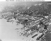
, Maryland and drains 14679 square miles (38,018.4 km²). The length of the river from the junction of its North and South Branches to Point Lookout is 302 miles (486 km). The average flow is 10,800 ft³/s (306 m³/s). The largest flow ever recorded on the Potomac at Washington, D.C. was in March 1936 when it reached 425,000 ft³/s (12,000 m³/s). The lowest flow ever recorded at the same location was 600 ft³/s (17 m³/s) in September 1966.
The river has two sources. The source of the North Branch is at the Fairfax Stone located at the junction of Grant
, Tucker
, Preston
counties in West Virginia
. The source of the South Branch is located near Hightown
in northern Highland County
, Virginia. The river's two branches converge just east of Green Spring
in Hampshire County
, West Virginia to form the Potomac.
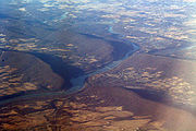
Once the Potomac drops from the Piedmont
to the Coastal Plain
, tides further influence the river as it passes through Washington, D.C. and beyond. Salinity
in the Potomac River Estuary
increases thereafter with distance downstream. The estuary also widens, reaching 11 statute miles (17 km) wide at its mouth, between Point Lookout, Maryland and Smith Point, Virginia before flowing into the Chesapeake Bay.
 "Potomac" is a European spelling of an Algonquian
name for a tribe subject to the Powhatan
confederacy, that inhabited the upper reaches of the Northern Neck
in the vicinity of Fredericksburg, Virginia
. Some accounts say the name means "place where people trade" or "the place to which tribute is brought". The natives called the river above the falls Cohongarooton, translated as "river of geese", and that area was renowned in early years for an abundance of both geese and swans. The spelling of the name has been simplified over the years from "Patawomeke" (as on Captain John Smith's map) to "Patowmack" in the 18th century and now "Potomac". Some scholars have also suggested it is rooted in the ancient Greek
for river, "potamos", blended with the Powhatan name "Patawomeke". The river's name was officially decided upon as Potomac by the Board on Geographic Names in 1931.
 The Potomac River brings together a variety of cultures throughout the watershed from the coal miners of upstream West Virginia to the urban residents of the nation's capital and, along the lower Potomac, the watermen of Virginia's Northern Neck.
Being situated in an area rich in American history and American heritage has led to the Potomac being nicknamed "the Nation's River." George Washington
, the first President of the United States
, was born in, surveyed, and spent most of his life within the Potomac basin. All of Washington, D.C., the nation's capital city
, also lies within the watershed. The 1859 siege of Harper's Ferry
at the river's confluence
with the Shenandoah
was a precursor to numerous epic battles of the American Civil War
in and around the Potomac and its tributaries, such as the 1861 Battle of Ball's Bluff and the 1862 Battle of Shepherdstown. General Robert E. Lee
crossed the river, thereby invading the North and threatening Washington, D.C., twice in campaigns climaxing in the battles of Antietam
and Gettysburg
.
 The Patowmack Canal
was intended by George Washington to connect the Tidewater region
near Georgetown with Cumberland
, Maryland. Started in 1785 on the Virginia side of the river, it was not completed until 1802. Financial troubles led to the closure of the canal
in 1830. The Chesapeake and Ohio Canal
operated along the banks of the Potomac in Maryland from 1831 to 1924 and also connected Cumberland to Washington, D.C. This allowed freight to be transported around the rapids known as the Great Falls of the Potomac River
, as well as many other, smaller rapids.
Washington, D.C. began using the Potomac as its principal source of drinking water
with the opening of the Washington Aqueduct
in 1864, using a water intake constructed at Great Falls.
President Bill Clinton
designated the Potomac as one of the American Heritage Rivers
in 1998.
.
 As a result of damaging floods in 1936 and 1937, the Army Corps of Engineers proposed a series of dam
s that were intended to regulate the river and to provide a more reliable water supply. One dam was to be built at Little Falls, just north of Washington, backing its pool up to Great Falls. Just above Great Falls, a much larger dam was proposed whose reservoir would extend to Harpers Ferry. Several other dams were proposed for the Potomac and its tributaries. When detailed studies were issued by the Corps in the 1950s, they met sustained opposition, led by US Supreme Court Chief Justice William O. Douglas
, resulting in the plans' abandonment. The only dam project that did get built was Jennings Randolph Lake
on the North Branch. The Corps built a supplementary water intake for the Washington Aqueduct at Little Falls in 1959.
In 1940 Congress
passed a law authorizing creation of an interstate compact
to coordinate water quality management among states in the Potomac basin. Maryland, West Virginia, Pennsylvania, Virginia, and the District of Columbia agreed to establish the Interstate Commission on the Potomac River Basin. The compact was amended in 1970 to include coordination of water supply issues and land use issues related to water quality.
Beginning in the 19th century, with increasing mining
and agriculture
upstream and urban sewage
and runoff
downstream, the water quality
of the Potomac River deteriorated. This created conditions of severe eutrophication
. It is said that President Abraham Lincoln
used to escape to the highlands on summer nights to escape the river's stench. In the 1960s, with dense green algal
blooms covering the river's surface, President Lyndon Johnson declared the river "a national disgrace" and set in motion a long-term effort to reduce pollution
from sewage
and restore the beauty and ecology of this historic river. One of significant pollution control projects at the time was the expansion of the Blue Plains Advanced Wastewater Treatment Plant
, which serves Washington and several surrounding communities. Enactment of the 1972 Clean Water Act
led to construction or expansion of additional sewage treatment
plants in the Potomac watershed. Controls on phosphorus
, one of the principal contributors to eutrophication, were implemented in the 1980s, through sewage plant upgrades and restrictions on phosphorus in detergents.
By the end of the 20th century, there was notable success, as massive algal blooms vanished and recreational fishing and boating rebounded. Still, the aquatic habitat
of the Potomac River and its tributaries remain vulnerable to eutrophication, heavy metals
, pesticide
s and other toxic chemicals, over-fishing, alien species, and pathogen
s associated with fecal coliform bacteria
and shellfish
diseases. In 2005 two federal agencies, the US Geological Survey and the Fish and Wildlife Service, began to identify fish in the Potomac and tributaries that exhibited "intersex" characteristics, as a result of endocrine disruption
caused by some form of pollution. On November 13, 2007, the Potomac Conservancy, an environmental group, issued the river a grade of "D-plus", citing high levels of pollution and the reports of "intersex" fish.
 For 400 years Maryland and Virginia have disputed control of the Potomac and its North Branch, since both states' original colonial charter
s grant the entire river rather than half of it as is normally the case with boundary rivers. In its first state constitution
adopted in 1776, Virginia ceded its claim to the entire river but reserved free use of it, an act disputed by Maryland. Both states acceded to the Compact of 1785 and the 1877 Black-Jenkins Award which grants Maryland the river bank-to-bank from the low water mark on the Virginia side, while permitting Virginia full riparian rights short of obstructing navigation.
From 1957 to 1996, the Maryland Department of the Environment (MDE) routinely issued permits applied for by Virginia entities concerning use of the Potomac. However, in 1996 the MDE denied a permit submitted by the Fairfax County Water Authority
to build a water intake 725 feet (220 m) offshore, citing potential harm to Maryland's interests by an increase in Virginia sprawl caused by the project. After years of failed appeals within the Maryland government's appeal processes, in 2000 Virginia took the case to the Supreme Court of the United States
, which exercises original jurisdiction in cases between two states. Maryland claimed Virginia lost its riparian rights by acquiescing to MDE's permit process for 63 years (MDE began its permit process in 1933). A Special Master
appointed by the Supreme Court to investigate recommended the case be settled in favor of Virginia, citing the language in the 1785 Compact and the 1877 Award. On December 9, 2003, the Court agreed in a 7-2 decision.
The original charters are silent as to which branch from the upper Potomac serves as the boundary, but this was settled by the 1785 Compact. When West Virginia seceded from Virginia in 1863, the question of West Virginia's succession in title to the lands between the branches of the river was raised, as well as title to the river itself. Claims by Maryland to West Virginia land north of the South Branch (all of Mineral
and Grant
Counties and parts of Hampshire
, Hardy
, Tucker
and Pendleton
Counties) and by West Virginia to the Potomac's high water mark were rejected by the Supreme Court in two separate decisions in 1910.
 The source of the North Branch Potomac River is at the Fairfax Stone
located at the junction of Grant
, Tucker
and Preston
counties in West Virginia.
From the Fairfax Stone, the North Branch Potomac River flows 27 miles (43.5 km) to the man-made Jennings Randolph Lake
, an impoundment
designed for flood control and emergency water supply. Below the dam, the North Branch cuts a serpentine path through the eastern Allegheny Mountains. First, it flows northeast by the communities of Bloomington
, Luke
, and Westernport
in Maryland and then on by Keyser
, West Virginia to Cumberland
, Maryland. At Cumberland, the river turns southeast. 103 miles (165.8 km) downstream from its source, the North Branch is joined by the South Branch between Green Spring
and South Branch Depot
, West Virginia from whence it flows past Hancock
, Maryland and turns southeast once more on its way toward Washington, D.C.
, and the Chesapeake Bay
.
The following are tributaries of the North Branch Potomac River, listed in order from the source to its mouth.
 The South Branch Potomac River has its headwaters in northwestern Highland County
, Virginia near Hightown
along the eastern edge of the Allegheny Front
. After a river distance of 139 miles (223.7 km), the mouth of the South Branch lies east of Green Spring
in Hampshire County
, West Virginia where it meets the North Branch Potomac River to form the Potomac. A topographic map
of the confluence of the North and South branches can be viewed here.
of the region, and thus the earliest white settlers, referred to the South Branch Potomac River as the Wappatomaka. Variants throughout the river's history included Wappatomica River, Wapacomo River, Wapocomo River, Wappacoma River, Wappatomaka River, South Branch of Potowmac River, South Branch of the Potowmac River, and South Fork Potomac River.
Places settled in the South Branch valley bearing variants of "Wappatomaka" include Wappocomo plantation
built in 1774 and the unincorporated
hamlet of Wappocomo
(sometimes spelled Wapocomo) at Hanging Rocks
, both north of Romney
on West Virginia Route 28.
) on the eastern side of Lantz Mountain (3,934 ft) in Highland County. From Hightown, the South Branch is a small meandering stream
that flows northeast along Crab Bottom Road through the communities of New Hampden
and Crab Bottom. At Forks of Waters, the South Branch joins with Strait Creek and flows north across the Virginia/West Virginia border into Pendleton County
. The river then travels on a northeastern course along the western side of Jack Mountain (4,045 ft), followed by Sandy Ridge (2,297 ft) along U.S. Route 220
. North of the confluence of the South Branch with Smith Creek, the river flows along Town Mountain (2,848 ft) around Franklin
at the junction of U.S. Route 220 and U.S. Route 33
. After Franklin, the South Branch continues north through the Monongahela National Forest
to Upper Tract
where it joins with three sizeable streams: Reeds Creek, Mill Run, and Deer Run. Between Big Mountain (2,582 ft) and Cave Mountain (2,821 ft), the South Branch bends around the Eagle Rock (1,483 ft) outcrop and continues its flow northward into Grant County
. Into Grant, the South Branch follows the western side of Cave Mountain through the 20 miles (32.2 km) long Smoke Hole Canyon
, until its confluence with the North Fork at Cabins
, where it flows east to Petersburg
. At Petersburg, the South Branch is joined with the South Branch Valley Railroad
, which it parallels until its mouth at Green Spring
.
 In its eastern course from Petersburg into Hardy County
, the South Branch becomes more navigable allowing for canoes and smaller river vessels. The river splits and forms a series of large islands while it heads northeast to Moorefield
. At Moorefield, the South Branch is joined by the South Fork South Branch Potomac River and runs north to Old Fields
where it is fed by Anderson Run and Stony Run. At McNeill
, the South Branch flows into the Trough
where it is bound to its west by Mill Creek Mountain
(2,119 ft) and to its east by Sawmill Ridge (1,644 ft). This area is the habitat to endangered bald eagles. The Trough passes into Hampshire County
and ends at its confluence with Sawmill Run south of Glebe
and Sector
. The South Branch continues north parallel to South Branch River Road (County Route 8) toward Romney
with a number of historic plantation farms adjoining it. En route to Romney, the river is fed by Buffalo Run, Mill Run
, McDowell Run, and Mill Creek
at Vanderlip
. The South Branch is traversed by the Northwestern Turnpike
(U.S. Route 50
) and joined by Sulphur Spring Run where it forms Valley View Island
to the west of town. Flowing north of Romney, the river still follows the eastern side of Mill Creek Mountain until it creates a horseshoe bend at Wappocomo
's Hanging Rocks
around the George W. Washington plantation, Ridgedale
. To the west of Three Churches
on the western side of South Branch Mountain
, 3,028 feet (923 m), the South Branch creates a series of bends and flows to the northeast by Springfield
through Blue's Ford. After another horseshoe bend, the South Branch flows under the old Baltimore and Ohio Railroad
mainline between Green Spring
and South Branch Depot
, and joins the North Branch to form the Potomac.
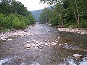 The North Fork South Branch Potomac River, 43.6 miles (70.2 km) long, forms just north of the Virginia/West Virginia border in Pendleton County
at the confluence of the Laurel Fork and Straight Fork along Big Mountain 3881 feet (1,182.9 m). From Circleville
, the North Fork flows northeast through Pendleton County between the Fore Knobs 2949 feet (898.9 m) to its west and the River Knobs
, 2,490 feet (759 m) to its east. At Seneca Rocks
, the North Fork is met by Seneca Creek
. From Seneca Rocks, the North Fork continues to flow northeast along the western edge of North Fork Mountain 3,389 feet (1033 m) into Grant County
. Flowing east through North Fork Gap, the North Fork joins the South Branch Potomac at the town of Cabins
, west of Petersburg
.
in Highland County
, Virginia
near Head Waters
and flows 68.4 miles (110.1 km) north-northeastward to the South Branch Potomac River at Moorefield
in Hardy County
, West Virginia
. From 1896 to 1929, it was named the Moorefield River by the Board on Geographic Names to avoid confusion with the South Branch.
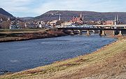
of the North and South Branches to the beginning of tidewater, just below the Little Falls of the Potomac River in Washington, D.C.
 The Tidal or Lower Potomac River lies below the fall line
. This stretch encompasses the Potomac from about one mile (2 km) below the Washington, DC - Montgomery County, Maryland
line, just below the Little Falls of the Potomac River where the tidal river begins, to the Chesapeake Bay
.
inhabit the Potomac, including but not limited to: bass
, muskellunge
, pike, walleye
, and, although rare, bull shark
s.
Chesapeake Bay
The Chesapeake Bay is the largest estuary in the United States. It lies off the Atlantic Ocean, surrounded by Maryland and Virginia. The Chesapeake Bay's drainage basin covers in the District of Columbia and parts of six states: New York, Pennsylvania, Delaware, Maryland, Virginia, and West...
, located along the mid-Atlantic
Atlantic Ocean
The Atlantic Ocean is the second-largest of the world's oceanic divisions. With a total area of about , it covers approximately 20% of the Earth's surface and about 26% of its water surface area...
coast of the United States
United States
The United States of America is a federal constitutional republic comprising fifty states and a federal district...
. The river
River
A river is a natural watercourse, usually freshwater, flowing towards an ocean, a lake, a sea, or another river. In a few cases, a river simply flows into the ground or dries up completely before reaching another body of water. Small rivers may also be called by several other names, including...
(main stem and North Branch) is approximately 405 miles (651.8 km) long, with a drainage area
Drainage basin
A drainage basin is an extent or an area of land where surface water from rain and melting snow or ice converges to a single point, usually the exit of the basin, where the waters join another waterbody, such as a river, lake, reservoir, estuary, wetland, sea, or ocean...
of about 14,700 square miles (38,000 km²). In terms of area, this makes the Potomac River the fourth largest river along the Atlantic coast of the United States and the 21st largest in the United States. Over 5 million people live within the Potomac watershed
Drainage basin
A drainage basin is an extent or an area of land where surface water from rain and melting snow or ice converges to a single point, usually the exit of the basin, where the waters join another waterbody, such as a river, lake, reservoir, estuary, wetland, sea, or ocean...
.
Geography
The river forms part of the borders between Washington, D.C.Washington, D.C.
Washington, D.C., formally the District of Columbia and commonly referred to as Washington, "the District", or simply D.C., is the capital of the United States. On July 16, 1790, the United States Congress approved the creation of a permanent national capital as permitted by the U.S. Constitution....
and Virginia
Virginia
The Commonwealth of Virginia , is a U.S. state on the Atlantic Coast of the Southern United States. Virginia is nicknamed the "Old Dominion" and sometimes the "Mother of Presidents" after the eight U.S. presidents born there...
on the left descending bank and Maryland
Maryland
Maryland is a U.S. state located in the Mid Atlantic region of the United States, bordering Virginia, West Virginia, and the District of Columbia to its south and west; Pennsylvania to its north; and Delaware to its east...
and Virginia
Virginia
The Commonwealth of Virginia , is a U.S. state on the Atlantic Coast of the Southern United States. Virginia is nicknamed the "Old Dominion" and sometimes the "Mother of Presidents" after the eight U.S. presidents born there...
on the river's right descending bank. The majority of the lower Potomac River is part of the State of Maryland. Exceptions include a small tidal portion within the District of Columbia, and the border with Virginia being delineated from "point to point" (thus various bays and shoreline indentations lie in Virginia). Except for a small portion of its headwaters in West Virginia, the North Branch Potomac River is considered part of Maryland to the low water mark on the opposite bank. The South Branch Potomac River lies completely within the state of West Virginia except for its headwaters, which lie in Virginia.
The Potomac River runs 405 miles (651.8 km) from the Fairfax Stone
Fairfax Stone
Fairfax Stone Historical Monument State Park is a West Virginia state park commemorating the Fairfax Stone, a surveyor's marker and boundary stone at the source of the North Branch of the Potomac River in West Virginia...
in West Virginia to Point Lookout
Point Lookout, Maryland
Point Lookout is a Maryland state park at the southern tip of St. Mary's County, Maryland. It is a peninsula formed by the confluence of the Chesapeake Bay and the Potomac River....
, Maryland and drains 14679 square miles (38,018.4 km²). The length of the river from the junction of its North and South Branches to Point Lookout is 302 miles (486 km). The average flow is 10,800 ft³/s (306 m³/s). The largest flow ever recorded on the Potomac at Washington, D.C. was in March 1936 when it reached 425,000 ft³/s (12,000 m³/s). The lowest flow ever recorded at the same location was 600 ft³/s (17 m³/s) in September 1966.
The river has two sources. The source of the North Branch is at the Fairfax Stone located at the junction of Grant
Grant County, West Virginia
As of the census of 2000, there were 11,299 people, 4,591 households, and 3,273 families residing in the county. The population density was 24 people per square mile . There were 6,105 housing units at an average density of 13 per square mile...
, Tucker
Tucker County, West Virginia
As of the census of 2000, there were 7,321 people, 3,052 households, and 2,121 families residing in the county. The population density was 18 people per square mile . There were 4,634 housing units at an average density of 11 per square mile...
, Preston
Preston County, West Virginia
As of the census of 2000, there were 29,334 people, 11,544 households, and 8,357 families residing in the county. The population density was 45 people per square mile . There were 13,444 housing units at an average density of 21 per square mile...
counties in West Virginia
West Virginia
West Virginia is a state in the Appalachian and Southeastern regions of the United States, bordered by Virginia to the southeast, Kentucky to the southwest, Ohio to the northwest, Pennsylvania to the northeast and Maryland to the east...
. The source of the South Branch is located near Hightown
Hightown, Virginia
Hightown is an unincorporated community at the crossroads of U.S. Route 250 and State Route 640 in Highland County, Virginia, United States. The main source of the South Branch Potomac River lies to the north of Hightown along State Route 640. It was originally known as Heveners Store. It is...
in northern Highland County
Highland County, Virginia
As of the census of 2000, there were 2,536 people, 1,131 households, and 764 families residing in the county. The population density was 6 people per square mile . There were 1,822 housing units at an average density of 4 per square mile...
, Virginia. The river's two branches converge just east of Green Spring
Green Spring, West Virginia
Green Spring is an unincorporated census-designated place and railroad town in Hampshire County, West Virginia, USA. As of the 2010 census, its population was 218. Green Spring is located north of Springfield on Green Spring Road near the confluence of the North and South Branches of the Potomac...
in Hampshire County
Hampshire County, West Virginia
Hampshire County is a county located in the U.S. state of West Virginia. As of 2010, the population was 23,964. Its county seat is Romney, West Virginia's oldest town . Hampshire County was created by the Virginia General Assembly on December 13, 1753, from parts of Frederick and Augusta counties ...
, West Virginia to form the Potomac.
Once the Potomac drops from the Piedmont
Piedmont (United States)
The Piedmont is a plateau region located in the eastern United States between the Atlantic Coastal Plain and the main Appalachian Mountains, stretching from New Jersey in the north to central Alabama in the south. The Piedmont province is a physiographic province of the larger Appalachian division...
to the Coastal Plain
Coastal plain
A coastal plain is an area of flat, low-lying land adjacent to a seacoast and separated from the interior by other features. One of the world's longest coastal plains is located in eastern South America. The southwestern coastal plain of North America is notable for its species diversity...
, tides further influence the river as it passes through Washington, D.C. and beyond. Salinity
Salinity
Salinity is the saltiness or dissolved salt content of a body of water. It is a general term used to describe the levels of different salts such as sodium chloride, magnesium and calcium sulfates, and bicarbonates...
in the Potomac River Estuary
Estuary
An estuary is a partly enclosed coastal body of water with one or more rivers or streams flowing into it, and with a free connection to the open sea....
increases thereafter with distance downstream. The estuary also widens, reaching 11 statute miles (17 km) wide at its mouth, between Point Lookout, Maryland and Smith Point, Virginia before flowing into the Chesapeake Bay.
History
Algonquian languages
The Algonquian languages also Algonkian) are a subfamily of Native American languages which includes most of the languages in the Algic language family. The name of the Algonquian language family is distinguished from the orthographically similar Algonquin dialect of the Ojibwe language, which is a...
name for a tribe subject to the Powhatan
Powhatan
The Powhatan is the name of a Virginia Indian confederation of tribes. It is estimated that there were about 14,000–21,000 of these native Powhatan people in eastern Virginia when the English settled Jamestown in 1607...
confederacy, that inhabited the upper reaches of the Northern Neck
Northern Neck
The Northern Neck is the northernmost of three peninsulas on the western shore of the Chesapeake Bay in the Commonwealth of Virginia. This peninsula is bounded by the Potomac River on the north and the Rappahannock River on the south. It encompasses the following Virginia counties: Lancaster,...
in the vicinity of Fredericksburg, Virginia
Fredericksburg, Virginia
Fredericksburg is an independent city in the Commonwealth of Virginia located south of Washington, D.C., and north of Richmond. As of the 2010 census, the city had a population of 24,286...
. Some accounts say the name means "place where people trade" or "the place to which tribute is brought". The natives called the river above the falls Cohongarooton, translated as "river of geese", and that area was renowned in early years for an abundance of both geese and swans. The spelling of the name has been simplified over the years from "Patawomeke" (as on Captain John Smith's map) to "Patowmack" in the 18th century and now "Potomac". Some scholars have also suggested it is rooted in the ancient Greek
Greek language
Greek is an independent branch of the Indo-European family of languages. Native to the southern Balkans, it has the longest documented history of any Indo-European language, spanning 34 centuries of written records. Its writing system has been the Greek alphabet for the majority of its history;...
for river, "potamos", blended with the Powhatan name "Patawomeke". The river's name was officially decided upon as Potomac by the Board on Geographic Names in 1931.
Being situated in an area rich in American history and American heritage has led to the Potomac being nicknamed "the Nation's River." George Washington
George Washington
George Washington was the dominant military and political leader of the new United States of America from 1775 to 1799. He led the American victory over Great Britain in the American Revolutionary War as commander-in-chief of the Continental Army from 1775 to 1783, and presided over the writing of...
, the first President of the United States
President of the United States
The President of the United States of America is the head of state and head of government of the United States. The president leads the executive branch of the federal government and is the commander-in-chief of the United States Armed Forces....
, was born in, surveyed, and spent most of his life within the Potomac basin. All of Washington, D.C., the nation's capital city
Capital City
Capital City was a television show produced by Euston Films which focused on the lives of investment bankers in London living and working on the corporate trading floor for the fictional international bank Shane-Longman....
, also lies within the watershed. The 1859 siege of Harper's Ferry
Harpers Ferry, West Virginia
Harpers Ferry is a historic town in Jefferson County, West Virginia, United States. In many books the town is called "Harper's Ferry" with an apostrophe....
at the river's confluence
Confluence (geography)
In geography, a confluence is the meeting of two or more bodies of water. It usually refers to the point where two streams flow together, merging into a single stream...
with the Shenandoah
Shenandoah River
The Shenandoah River is a tributary of the Potomac River, long with two forks approximately long each, in the U.S. states of Virginia and West Virginia...
was a precursor to numerous epic battles of the American Civil War
American Civil War
The American Civil War was a civil war fought in the United States of America. In response to the election of Abraham Lincoln as President of the United States, 11 southern slave states declared their secession from the United States and formed the Confederate States of America ; the other 25...
in and around the Potomac and its tributaries, such as the 1861 Battle of Ball's Bluff and the 1862 Battle of Shepherdstown. General Robert E. Lee
Robert E. Lee
Robert Edward Lee was a career military officer who is best known for having commanded the Confederate Army of Northern Virginia in the American Civil War....
crossed the river, thereby invading the North and threatening Washington, D.C., twice in campaigns climaxing in the battles of Antietam
Battle of Antietam
The Battle of Antietam , fought on September 17, 1862, near Sharpsburg, Maryland, and Antietam Creek, as part of the Maryland Campaign, was the first major battle in the American Civil War to take place on Northern soil. It was the bloodiest single-day battle in American history, with about 23,000...
and Gettysburg
Battle of Gettysburg
The Battle of Gettysburg , was fought July 1–3, 1863, in and around the town of Gettysburg, Pennsylvania. The battle with the largest number of casualties in the American Civil War, it is often described as the war's turning point. Union Maj. Gen. George Gordon Meade's Army of the Potomac...
.
Patowmack Canal
The Patowmack Canal is an inoperative canal located in Virginia, United States, that was designed to bypass rapids in the Potomac River upstream of the present Washington, D.C. area...
was intended by George Washington to connect the Tidewater region
Tidewater region of Virginia
The Tidewater region of Virginia is the eastern portion of the Commonwealth of Virginia formally known as Hampton Roads. The term tidewater may be correctly applied to all portions of any area, including Virginia, where the water level is affected by the tides...
near Georgetown with Cumberland
Cumberland, Maryland
Cumberland is a city in the far western, Appalachian portion of Maryland, United States. It is the county seat of Allegany County, and the primary city of the Cumberland, MD-WV Metropolitan Statistical Area. At the 2010 census, the city had a population of 20,859, and the metropolitan area had a...
, Maryland. Started in 1785 on the Virginia side of the river, it was not completed until 1802. Financial troubles led to the closure of the canal
Canal
Canals are man-made channels for water. There are two types of canal:#Waterways: navigable transportation canals used for carrying ships and boats shipping goods and conveying people, further subdivided into two kinds:...
in 1830. The Chesapeake and Ohio Canal
Chesapeake and Ohio Canal
The Chesapeake and Ohio Canal, abbreviated as the C&O Canal, and occasionally referred to as the "Grand Old Ditch," operated from 1831 until 1924 parallel to the Potomac River in Maryland from Cumberland, Maryland to Washington, D.C. The total length of the canal is about . The elevation change of...
operated along the banks of the Potomac in Maryland from 1831 to 1924 and also connected Cumberland to Washington, D.C. This allowed freight to be transported around the rapids known as the Great Falls of the Potomac River
Great Falls of the Potomac River
The Great Falls of the Potomac River are located at the fall line of the Potomac River, upstream from Washington, D.C. Great Falls Park, operated by the National Park Service, is located on the southern banks in Virginia, while Chesapeake and Ohio Canal parkland is located along the northern banks...
, as well as many other, smaller rapids.
Washington, D.C. began using the Potomac as its principal source of drinking water
Drinking water
Drinking water or potable water is water pure enough to be consumed or used with low risk of immediate or long term harm. In most developed countries, the water supplied to households, commerce and industry is all of drinking water standard, even though only a very small proportion is actually...
with the opening of the Washington Aqueduct
Washington Aqueduct
The Washington Aqueduct is an aqueduct that provides the public water supply system serving Washington, D.C., and parts of its suburbs. One of the first major aqueduct projects in the United States, the Aqueduct was commissioned by Congress in 1852, and construction began in 1853 under the...
in 1864, using a water intake constructed at Great Falls.
President Bill Clinton
Bill Clinton
William Jefferson "Bill" Clinton is an American politician who served as the 42nd President of the United States from 1993 to 2001. Inaugurated at age 46, he was the third-youngest president. He took office at the end of the Cold War, and was the first president of the baby boomer generation...
designated the Potomac as one of the American Heritage Rivers
American Heritage Rivers
American Heritage Rivers are designated by the United States Environmental Protection Agency to receive special attention to further three objectives: natural resource and environmental protection, economic revitalization, and historic and cultural preservation.The American Heritage Rivers...
in 1998.
Water supply and water quality
An average of approximately 486 million USgals (1,839,710.2 m³) of water per day is withdrawn daily in the Washington area for water supplyWater supply
Water supply is the provision of water by public utilities, commercial organisations, community endeavours or by individuals, usually via a system of pumps and pipes...
.
Dam
A dam is a barrier that impounds water or underground streams. Dams generally serve the primary purpose of retaining water, while other structures such as floodgates or levees are used to manage or prevent water flow into specific land regions. Hydropower and pumped-storage hydroelectricity are...
s that were intended to regulate the river and to provide a more reliable water supply. One dam was to be built at Little Falls, just north of Washington, backing its pool up to Great Falls. Just above Great Falls, a much larger dam was proposed whose reservoir would extend to Harpers Ferry. Several other dams were proposed for the Potomac and its tributaries. When detailed studies were issued by the Corps in the 1950s, they met sustained opposition, led by US Supreme Court Chief Justice William O. Douglas
William O. Douglas
William Orville Douglas was an Associate Justice of the United States Supreme Court. With a term lasting 36 years and 209 days, he is the longest-serving justice in the history of the Supreme Court...
, resulting in the plans' abandonment. The only dam project that did get built was Jennings Randolph Lake
Jennings Randolph Lake
Jennings Randolph Lake is a reservoir of located on the North Branch Potomac River in Garrett County, Maryland and Mineral County, West Virginia. It is approximately eight miles upstream of Bloomington, Maryland, and approximately five miles north of Elk Garden, West Virginia.-Construction and...
on the North Branch. The Corps built a supplementary water intake for the Washington Aqueduct at Little Falls in 1959.
In 1940 Congress
United States Congress
The United States Congress is the bicameral legislature of the federal government of the United States, consisting of the Senate and the House of Representatives. The Congress meets in the United States Capitol in Washington, D.C....
passed a law authorizing creation of an interstate compact
Interstate compact
An interstate compact is an agreement between two or more states of the United States of America. Article I, Section 10 of the United States Constitution provides that "no state shall enter into an agreement or compact with another state" without the consent of Congress...
to coordinate water quality management among states in the Potomac basin. Maryland, West Virginia, Pennsylvania, Virginia, and the District of Columbia agreed to establish the Interstate Commission on the Potomac River Basin. The compact was amended in 1970 to include coordination of water supply issues and land use issues related to water quality.
Beginning in the 19th century, with increasing mining
Mining
Mining is the extraction of valuable minerals or other geological materials from the earth, from an ore body, vein or seam. The term also includes the removal of soil. Materials recovered by mining include base metals, precious metals, iron, uranium, coal, diamonds, limestone, oil shale, rock...
and agriculture
Agriculture
Agriculture is the cultivation of animals, plants, fungi and other life forms for food, fiber, and other products used to sustain life. Agriculture was the key implement in the rise of sedentary human civilization, whereby farming of domesticated species created food surpluses that nurtured the...
upstream and urban sewage
Sewage
Sewage is water-carried waste, in solution or suspension, that is intended to be removed from a community. Also known as wastewater, it is more than 99% water and is characterized by volume or rate of flow, physical condition, chemical constituents and the bacteriological organisms that it contains...
and runoff
Surface runoff
Surface runoff is the water flow that occurs when soil is infiltrated to full capacity and excess water from rain, meltwater, or other sources flows over the land. This is a major component of the water cycle. Runoff that occurs on surfaces before reaching a channel is also called a nonpoint source...
downstream, the water quality
Water quality
Water quality is the physical, chemical and biological characteristics of water. It is a measure of the condition of water relative to the requirements of one or more biotic species and or to any human need or purpose. It is most frequently used by reference to a set of standards against which...
of the Potomac River deteriorated. This created conditions of severe eutrophication
Eutrophication
Eutrophication or more precisely hypertrophication, is the movement of a body of water′s trophic status in the direction of increasing plant biomass, by the addition of artificial or natural substances, such as nitrates and phosphates, through fertilizers or sewage, to an aquatic system...
. It is said that President Abraham Lincoln
Abraham Lincoln
Abraham Lincoln was the 16th President of the United States, serving from March 1861 until his assassination in April 1865. He successfully led his country through a great constitutional, military and moral crisis – the American Civil War – preserving the Union, while ending slavery, and...
used to escape to the highlands on summer nights to escape the river's stench. In the 1960s, with dense green algal
Algae
Algae are a large and diverse group of simple, typically autotrophic organisms, ranging from unicellular to multicellular forms, such as the giant kelps that grow to 65 meters in length. They are photosynthetic like plants, and "simple" because their tissues are not organized into the many...
blooms covering the river's surface, President Lyndon Johnson declared the river "a national disgrace" and set in motion a long-term effort to reduce pollution
Water pollution
Water pollution is the contamination of water bodies . Water pollution occurs when pollutants are discharged directly or indirectly into water bodies without adequate treatment to remove harmful compounds....
from sewage
Sewage
Sewage is water-carried waste, in solution or suspension, that is intended to be removed from a community. Also known as wastewater, it is more than 99% water and is characterized by volume or rate of flow, physical condition, chemical constituents and the bacteriological organisms that it contains...
and restore the beauty and ecology of this historic river. One of significant pollution control projects at the time was the expansion of the Blue Plains Advanced Wastewater Treatment Plant
District of Columbia Water and Sewer Authority
The District of Columbia Water and Sewer Authority provides drinking water, sewage collection and wastewater treatment in Washington, D.C., USA. DC Water also provides wholesale wastewater treatment services to several adjoining municipalities in Maryland and Virginia...
, which serves Washington and several surrounding communities. Enactment of the 1972 Clean Water Act
Clean Water Act
The Clean Water Act is the primary federal law in the United States governing water pollution. Commonly abbreviated as the CWA, the act established the goals of eliminating releases of high amounts of toxic substances into water, eliminating additional water pollution by 1985, and ensuring that...
led to construction or expansion of additional sewage treatment
Sewage treatment
Sewage treatment, or domestic wastewater treatment, is the process of removing contaminants from wastewater and household sewage, both runoff and domestic. It includes physical, chemical, and biological processes to remove physical, chemical and biological contaminants...
plants in the Potomac watershed. Controls on phosphorus
Phosphorus
Phosphorus is the chemical element that has the symbol P and atomic number 15. A multivalent nonmetal of the nitrogen group, phosphorus as a mineral is almost always present in its maximally oxidized state, as inorganic phosphate rocks...
, one of the principal contributors to eutrophication, were implemented in the 1980s, through sewage plant upgrades and restrictions on phosphorus in detergents.
By the end of the 20th century, there was notable success, as massive algal blooms vanished and recreational fishing and boating rebounded. Still, the aquatic habitat
Habitat (ecology)
A habitat is an ecological or environmental area that is inhabited by a particular species of animal, plant or other type of organism...
of the Potomac River and its tributaries remain vulnerable to eutrophication, heavy metals
Heavy metals
A heavy metal is a member of a loosely-defined subset of elements that exhibit metallic properties. It mainly includes the transition metals, some metalloids, lanthanides, and actinides. Many different definitions have been proposed—some based on density, some on atomic number or atomic weight,...
, pesticide
Pesticide
Pesticides are substances or mixture of substances intended for preventing, destroying, repelling or mitigating any pest.A pesticide may be a chemical unicycle, biological agent , antimicrobial, disinfectant or device used against any pest...
s and other toxic chemicals, over-fishing, alien species, and pathogen
Pathogen
A pathogen gignomai "I give birth to") or infectious agent — colloquially, a germ — is a microbe or microorganism such as a virus, bacterium, prion, or fungus that causes disease in its animal or plant host...
s associated with fecal coliform bacteria
Bacteria
Bacteria are a large domain of prokaryotic microorganisms. Typically a few micrometres in length, bacteria have a wide range of shapes, ranging from spheres to rods and spirals...
and shellfish
Shellfish
Shellfish is a culinary and fisheries term for exoskeleton-bearing aquatic invertebrates used as food, including various species of molluscs, crustaceans, and echinoderms. Although most kinds of shellfish are harvested from saltwater environments, some kinds are found only in freshwater...
diseases. In 2005 two federal agencies, the US Geological Survey and the Fish and Wildlife Service, began to identify fish in the Potomac and tributaries that exhibited "intersex" characteristics, as a result of endocrine disruption
Endocrine disruptor
Endocrine disruptors are chemicals that interfere with endocrine in animals, including humans. These disruptions can cause cancerous tumors, birth defects, and other developmental disorders...
caused by some form of pollution. On November 13, 2007, the Potomac Conservancy, an environmental group, issued the river a grade of "D-plus", citing high levels of pollution and the reports of "intersex" fish.
Legal issues
Colonial charter
A charter is a document that gave colonies the legal rights to exist.A charter is a document bestowing certain rights on a town, city, university or an institution....
s grant the entire river rather than half of it as is normally the case with boundary rivers. In its first state constitution
Constitution
A constitution is a set of fundamental principles or established precedents according to which a state or other organization is governed. These rules together make up, i.e. constitute, what the entity is...
adopted in 1776, Virginia ceded its claim to the entire river but reserved free use of it, an act disputed by Maryland. Both states acceded to the Compact of 1785 and the 1877 Black-Jenkins Award which grants Maryland the river bank-to-bank from the low water mark on the Virginia side, while permitting Virginia full riparian rights short of obstructing navigation.
From 1957 to 1996, the Maryland Department of the Environment (MDE) routinely issued permits applied for by Virginia entities concerning use of the Potomac. However, in 1996 the MDE denied a permit submitted by the Fairfax County Water Authority
Fairfax County Water Authority
Fairfax County Water Authority is the main water company in the Northern Virginia region of the United States, and one of the three major water providers in the Washington, D.C. metropolitan area...
to build a water intake 725 feet (220 m) offshore, citing potential harm to Maryland's interests by an increase in Virginia sprawl caused by the project. After years of failed appeals within the Maryland government's appeal processes, in 2000 Virginia took the case to the Supreme Court of the United States
Supreme Court of the United States
The Supreme Court of the United States is the highest court in the United States. It has ultimate appellate jurisdiction over all state and federal courts, and original jurisdiction over a small range of cases...
, which exercises original jurisdiction in cases between two states. Maryland claimed Virginia lost its riparian rights by acquiescing to MDE's permit process for 63 years (MDE began its permit process in 1933). A Special Master
Special master
In law, a special master is an authority appointed by a judge to make sure that judicial orders are actually followed.In England, at common law, there were "Masters in Chancery," who acted in aid of the Equity Courts. There were also "Masters in Lunacy," who conducted inquiries of the same nature...
appointed by the Supreme Court to investigate recommended the case be settled in favor of Virginia, citing the language in the 1785 Compact and the 1877 Award. On December 9, 2003, the Court agreed in a 7-2 decision.
The original charters are silent as to which branch from the upper Potomac serves as the boundary, but this was settled by the 1785 Compact. When West Virginia seceded from Virginia in 1863, the question of West Virginia's succession in title to the lands between the branches of the river was raised, as well as title to the river itself. Claims by Maryland to West Virginia land north of the South Branch (all of Mineral
Mineral County, West Virginia
Mineral County is a county located in the U.S. state of West Virginia. It is part of the Cumberland, MD-WV Metropolitan Statistical Area. As of 2010, the population was 28,212. Its county seat is Keyser.-Ancient history:...
and Grant
Grant County, West Virginia
As of the census of 2000, there were 11,299 people, 4,591 households, and 3,273 families residing in the county. The population density was 24 people per square mile . There were 6,105 housing units at an average density of 13 per square mile...
Counties and parts of Hampshire
Hampshire County, West Virginia
Hampshire County is a county located in the U.S. state of West Virginia. As of 2010, the population was 23,964. Its county seat is Romney, West Virginia's oldest town . Hampshire County was created by the Virginia General Assembly on December 13, 1753, from parts of Frederick and Augusta counties ...
, Hardy
Hardy County, West Virginia
As of the census of 2000, there were 12,669 people, 5,204 households, and 3,564 families residing in the county. The population density was 22 people per square mile . There were 7,115 housing units at an average density of 12 per square mile...
, Tucker
Tucker County, West Virginia
As of the census of 2000, there were 7,321 people, 3,052 households, and 2,121 families residing in the county. The population density was 18 people per square mile . There were 4,634 housing units at an average density of 11 per square mile...
and Pendleton
Pendleton County, West Virginia
As of the census of 2000, there were 8,196 people, 3,350 households, and 2,355 families residing in the county. The population density was 12 people per square mile . There were 5,102 housing units at an average density of 7 per square mile...
Counties) and by West Virginia to the Potomac's high water mark were rejected by the Supreme Court in two separate decisions in 1910.
North Branch Potomac River
Fairfax Stone
Fairfax Stone Historical Monument State Park is a West Virginia state park commemorating the Fairfax Stone, a surveyor's marker and boundary stone at the source of the North Branch of the Potomac River in West Virginia...
located at the junction of Grant
Grant County, West Virginia
As of the census of 2000, there were 11,299 people, 4,591 households, and 3,273 families residing in the county. The population density was 24 people per square mile . There were 6,105 housing units at an average density of 13 per square mile...
, Tucker
Tucker County, West Virginia
As of the census of 2000, there were 7,321 people, 3,052 households, and 2,121 families residing in the county. The population density was 18 people per square mile . There were 4,634 housing units at an average density of 11 per square mile...
and Preston
Preston County, West Virginia
As of the census of 2000, there were 29,334 people, 11,544 households, and 8,357 families residing in the county. The population density was 45 people per square mile . There were 13,444 housing units at an average density of 21 per square mile...
counties in West Virginia.
From the Fairfax Stone, the North Branch Potomac River flows 27 miles (43.5 km) to the man-made Jennings Randolph Lake
Jennings Randolph Lake
Jennings Randolph Lake is a reservoir of located on the North Branch Potomac River in Garrett County, Maryland and Mineral County, West Virginia. It is approximately eight miles upstream of Bloomington, Maryland, and approximately five miles north of Elk Garden, West Virginia.-Construction and...
, an impoundment
Impoundment
Impoundment is the election of a President of the United States not to spend money that has been appropriated by the U.S. Congress. The precedent for presidential impoundment was first set by Thomas Jefferson in 1801. The power was available to all presidents up to and including Richard Nixon, and...
designed for flood control and emergency water supply. Below the dam, the North Branch cuts a serpentine path through the eastern Allegheny Mountains. First, it flows northeast by the communities of Bloomington
Bloomington, Maryland
Bloomington is an unincorporated town at the confluence of the North Branch Potomac River and Savage River in southeastern Garrett County, Maryland...
, Luke
Luke, Maryland
Luke is a town in Allegany County, Maryland, United States located along the Georges Creek Valley. Known originally as West Piedmont, the town is part of the Cumberland, MD-WV Metropolitan Statistical Area. The population was 80 at the 2000 census....
, and Westernport
Westernport, Maryland
Westernport is a town in Allegany County, Maryland, United States, located along the Georges Creek Valley. It is part of the Cumberland, MD-WV Metropolitan Statistical Area. The population was 2,104 at the 2000 census.-History:...
in Maryland and then on by Keyser
Keyser, West Virginia
Keyser is a city in and the county seat of Mineral County, West Virginia, United States. It is part of the Cumberland, MD-WV Metropolitan Statistical Area. The population was 5,303 at the 2000 census.- History :...
, West Virginia to Cumberland
Cumberland, Maryland
Cumberland is a city in the far western, Appalachian portion of Maryland, United States. It is the county seat of Allegany County, and the primary city of the Cumberland, MD-WV Metropolitan Statistical Area. At the 2010 census, the city had a population of 20,859, and the metropolitan area had a...
, Maryland. At Cumberland, the river turns southeast. 103 miles (165.8 km) downstream from its source, the North Branch is joined by the South Branch between Green Spring
Green Spring, West Virginia
Green Spring is an unincorporated census-designated place and railroad town in Hampshire County, West Virginia, USA. As of the 2010 census, its population was 218. Green Spring is located north of Springfield on Green Spring Road near the confluence of the North and South Branches of the Potomac...
and South Branch Depot
South Branch Depot, West Virginia
South Branch Depot is an unincorporated community in Hampshire County in the U.S. state of West Virginia. Originally known as Forks of Potomac because of its proximity to the confluence of the North and South Branches of the Potomac River and then later in the early 20th century as French's Station...
, West Virginia from whence it flows past Hancock
Hancock, Maryland
Hancock is a town in Washington County, Maryland, United States. The population was 1,725 at the 2000 census. The Western Maryland community is notable for being located at the narrowest part of the state...
, Maryland and turns southeast once more on its way toward Washington, D.C.
Washington, D.C.
Washington, D.C., formally the District of Columbia and commonly referred to as Washington, "the District", or simply D.C., is the capital of the United States. On July 16, 1790, the United States Congress approved the creation of a permanent national capital as permitted by the U.S. Constitution....
, and the Chesapeake Bay
Chesapeake Bay
The Chesapeake Bay is the largest estuary in the United States. It lies off the Atlantic Ocean, surrounded by Maryland and Virginia. The Chesapeake Bay's drainage basin covers in the District of Columbia and parts of six states: New York, Pennsylvania, Delaware, Maryland, Virginia, and West...
.
The following are tributaries of the North Branch Potomac River, listed in order from the source to its mouth.
- Stony RiverStony River (North Branch Potomac River)The Stony River is a tributary of the North Branch Potomac River in Grant County in West Virginia's Eastern Panhandle. The Stony River joins with the North Branch at the Mineral County border...
(West Virginia) - Abram CreekAbram CreekAbram Creek is a tributary stream of the North Branch Potomac River in Grant and Mineral counties in West Virginia's Eastern Panhandle.-Variant names:In 1895, the Board on Geographic Names officially decided upon Abram Creek as the stream's name...
(West Virginia) - Savage RiverSavage River (Maryland)The Savage River is a river in Garrett County, Maryland, and is the first major tributary of the North Branch Potomac River from its source. The river was named for 18th century surveyor John Savage....
(Maryland) - Georges CreekGeorges CreekGeorges Creek is a tributary stream of the North Branch Potomac River in western Maryland. The creek has its headwaters near Frostburg and empties into the North Branch Potomac River at Westernport, all in western Allegany County. Along the Georges Creek Valley, there exists a series of small...
(Maryland)- Laurel RunLaurel Run (Georges Creek)Laurel Run is a tributary stream of Georges Creek in Allegany County, Maryland. The creek rises about northwest of Lonaconing and empties into Georges Creek north of Barton.-References:...
(Maryland)
- Laurel Run
- New CreekNew CreekNew Creek is an stream in eastern West Virginia in the United States. It is the third major West Virginia tributary to the North Branch Potomac River. Via the Potomac, it is part of the watershed of Chesapeake Bay.-Course:...
(West Virginia) - Limestone RunLimestone RunLimestone Run is a stream that lies to the east of New Creek Mountain in Mineral County, West Virginia. It is a tributary of the North Branch Potomac River....
(West Virginia) - Warrior Run (Maryland)
- Wills CreekWills Creek (North Branch Potomac River)Wills Creek is a tributary of the North Branch Potomac River in Pennsylvania and Maryland in the United States.Wills Creek drops off the Allegheny Mountains of southeastern Somerset County, Pennsylvania, and enters the North Branch Potomac River at Cumberland, Maryland.-History:thumb|220px|Fort...
(Pennsylvania/Maryland)- Brush CreekBrush Creek (Wills Creek)Brush Creek is a tributary of Wills Creek in Pennsylvania in the United States.Brush Creek drains a piece of the Allegheny Plateau in Somerset County, and enters Wills Creek just above the Railroad Cut Falls at Fairhope.-References:...
(Pennsylvania) - Little Wills CreekLittle Wills CreekLittle Wills Creek is a tributary of Wills Creek in Bedford County, Pennsylvania, in the United States.Little Wills Creek flows down a valley between the Allegheny Front and Wills Mountain, drawing most of its water from the Allegheny Plateau, and enters Wills Creek just below...
(Pennsylvania)
- Brush Creek
- Evitts Creek (Maryland and Pennsylvania)
- Patterson CreekPatterson CreekPatterson Creek is a tributary of the North Branch Potomac River in West Virginia's Eastern Panhandle, in the United States. It enters the North Branch east of Cumberland, Maryland, with its headwaters located in Grant County, West Virginia...
(West Virginia)- Mill CreekMill Creek (Patterson Creek)Mill Creek is an tributary stream of Patterson Creek in Mineral County, West Virginia. It is also known as Mill Run.-Headwaters and course:...
(West Virginia)
- Mill Creek
- Dans RunDans RunDans Run is a non-navigable tributary stream of the North Branch Potomac River in Mineral County, West Virginia. Dans Run rises to the east of Patterson Creek Mountain and empties into the North Branch at the community of Dans Run on the old Baltimore & Ohio Railroad. Dans Run Island in the North...
(West Virginia) - Green Spring RunGreen Spring RunGreen Spring Run is an tributary stream of the North Branch Potomac River in Hampshire County in the U.S. state of West Virginia. Green Spring Run rises in Greenwood Hollow north of Springfield and meanders northeast through Green Spring Valley. The South Branch Valley Railroad and Green Spring...
(West Virginia)
South Branch Potomac River
Highland County, Virginia
As of the census of 2000, there were 2,536 people, 1,131 households, and 764 families residing in the county. The population density was 6 people per square mile . There were 1,822 housing units at an average density of 4 per square mile...
, Virginia near Hightown
Hightown, Virginia
Hightown is an unincorporated community at the crossroads of U.S. Route 250 and State Route 640 in Highland County, Virginia, United States. The main source of the South Branch Potomac River lies to the north of Hightown along State Route 640. It was originally known as Heveners Store. It is...
along the eastern edge of the Allegheny Front
Allegheny Front
The Allegheny Front is the major southeast- or east-facing escarpment in the Allegheny Mountains in southern Pennsylvania, western Maryland, and eastern West Virginia, USA. The Allegheny Front delineates the Ridge-and-Valley Appalachians to its east from the Appalachian Plateau to its west...
. After a river distance of 139 miles (223.7 km), the mouth of the South Branch lies east of Green Spring
Green Spring, West Virginia
Green Spring is an unincorporated census-designated place and railroad town in Hampshire County, West Virginia, USA. As of the 2010 census, its population was 218. Green Spring is located north of Springfield on Green Spring Road near the confluence of the North and South Branches of the Potomac...
in Hampshire County
Hampshire County, West Virginia
Hampshire County is a county located in the U.S. state of West Virginia. As of 2010, the population was 23,964. Its county seat is Romney, West Virginia's oldest town . Hampshire County was created by the Virginia General Assembly on December 13, 1753, from parts of Frederick and Augusta counties ...
, West Virginia where it meets the North Branch Potomac River to form the Potomac. A topographic map
Topographic map
A topographic map is a type of map characterized by large-scale detail and quantitative representation of relief, usually using contour lines in modern mapping, but historically using a variety of methods. Traditional definitions require a topographic map to show both natural and man-made features...
of the confluence of the North and South branches can be viewed here.
South Branch nomenclature
The Native AmericansNative Americans in the United States
Native Americans in the United States are the indigenous peoples in North America within the boundaries of the present-day continental United States, parts of Alaska, and the island state of Hawaii. They are composed of numerous, distinct tribes, states, and ethnic groups, many of which survive as...
of the region, and thus the earliest white settlers, referred to the South Branch Potomac River as the Wappatomaka. Variants throughout the river's history included Wappatomica River, Wapacomo River, Wapocomo River, Wappacoma River, Wappatomaka River, South Branch of Potowmac River, South Branch of the Potowmac River, and South Fork Potomac River.
Places settled in the South Branch valley bearing variants of "Wappatomaka" include Wappocomo plantation
Wappocomo (plantation)
Wappocomo is a late 18th-century Georgian mansion overlooking the South Branch Potomac River north of Romney, West Virginia, United States. Wappocomo lies along West Virginia Route 28 and the South Branch Valley Railroad...
built in 1774 and the unincorporated
Unincorporated area
In law, an unincorporated area is a region of land that is not a part of any municipality.To "incorporate" in this context means to form a municipal corporation, a city, town, or village with its own government. An unincorporated community is usually not subject to or taxed by a municipal government...
hamlet of Wappocomo
Wappocomo, West Virginia
Wappocomo is an unincorporated community in Hampshire County in the U.S. state of West Virginia. The community is located south of Springfield on West Virginia Route 28 at Hanging Rocks along the South Branch Potomac River...
(sometimes spelled Wapocomo) at Hanging Rocks
Hanging Rocks
Hanging Rocks are perpendicular cliffs rising nearly above the South Branch Potomac River in Hampshire County in the U.S. state of West Virginia. Hanging Rocks are located four miles north of Romney at Wappocomo on West Virginia Route 28. Hanging Rocks has also been known throughout its history...
, both north of Romney
Romney, West Virginia
Romney is a city in and the county seat of Hampshire County, West Virginia, United States. The population was 1,940 at the 2000 census, while the area covered by the city's ZIP code had a population of 5,873. It is a city with a very historic background dating back to the 18th century...
on West Virginia Route 28.
South Branch headwaters and course
The exact location of the South Branch's source is northwest of Hightown along Parkersburg Pike (U.S. Route 250U.S. Route 250
U.S. Route 250 is a route of the United States Numbered Highway System, and is a spur of U.S. Route 50. It currently runs for from Sandusky, Ohio to Richmond, Virginia. It passes through the states of Virginia, West Virginia, and Ohio. It goes through the cities of Richmond, Virginia,...
) on the eastern side of Lantz Mountain (3,934 ft) in Highland County. From Hightown, the South Branch is a small meandering stream
Stream
A stream is a body of water with a current, confined within a bed and stream banks. Depending on its locale or certain characteristics, a stream may be referred to as a branch, brook, beck, burn, creek, "crick", gill , kill, lick, rill, river, syke, bayou, rivulet, streamage, wash, run or...
that flows northeast along Crab Bottom Road through the communities of New Hampden
New Hampden, Virginia
New Hampden is an unincorporated community in Highland County, Virginia, United States. New Hampden is located on the South Branch Potomac River in Bluegrass Valley....
and Crab Bottom. At Forks of Waters, the South Branch joins with Strait Creek and flows north across the Virginia/West Virginia border into Pendleton County
Pendleton County, West Virginia
As of the census of 2000, there were 8,196 people, 3,350 households, and 2,355 families residing in the county. The population density was 12 people per square mile . There were 5,102 housing units at an average density of 7 per square mile...
. The river then travels on a northeastern course along the western side of Jack Mountain (4,045 ft), followed by Sandy Ridge (2,297 ft) along U.S. Route 220
U.S. Route 220
U.S. Route 220 is a long U.S. Route in the eastern United States.US 220 is a spur route of U.S. Route 20 but at present, the two routes do not intersect nor do they connect via other spurs of US 20. The former U. S. Route 120, which was signed in Pennsylvania between 1926 and 1967, intersected...
. North of the confluence of the South Branch with Smith Creek, the river flows along Town Mountain (2,848 ft) around Franklin
Franklin, West Virginia
Franklin is a town in Pendleton County, West Virginia, United States. The population was 797 at the 2000 census. It is the county seat of Pendleton County...
at the junction of U.S. Route 220 and U.S. Route 33
U.S. Route 33
U.S. Route 33 is a United States federal highway that runs northwest-southeast for 709 miles from northern Indiana to Richmond, Virginia, passing through Ohio and West Virginia en route. Although most odd-numbered U.S...
. After Franklin, the South Branch continues north through the Monongahela National Forest
Monongahela National Forest
The Monongahela National Forest is a national forest located in the Allegheny Mountains of eastern West Virginia, USA. It protects over of federally-owned land within a proclamation boundary that includes much of the Potomac Highlands Region and portions of 10 counties.The MNF includes some...
to Upper Tract
Upper Tract, West Virginia
Upper Tract is an unincorporated community located in Pendleton County, West Virginia, USA. The community lies along U.S. Highway 220 at the confluence of Reeds Creek and the South Branch Potomac River....
where it joins with three sizeable streams: Reeds Creek, Mill Run, and Deer Run. Between Big Mountain (2,582 ft) and Cave Mountain (2,821 ft), the South Branch bends around the Eagle Rock (1,483 ft) outcrop and continues its flow northward into Grant County
Grant County, West Virginia
As of the census of 2000, there were 11,299 people, 4,591 households, and 3,273 families residing in the county. The population density was 24 people per square mile . There were 6,105 housing units at an average density of 13 per square mile...
. Into Grant, the South Branch follows the western side of Cave Mountain through the 20 miles (32.2 km) long Smoke Hole Canyon
Smoke Hole Canyon
Smoke Hole Canyon — often called simply the Smoke Hole — is a rugged long gorge carved by the South Branch Potomac River in the Allegheny Mountains of eastern West Virginia, USA...
, until its confluence with the North Fork at Cabins
Cabins, West Virginia
Cabins is an unincorporated community on the North Fork South Branch Potomac River in Grant County, West Virginia, USA. Cabins lies within the Spruce Knob-Seneca Rocks National Recreation Area of the Monongahela National Forest....
, where it flows east to Petersburg
Petersburg, West Virginia
Petersburg is a city in Grant County, West Virginia, United States. The population was 2,423 at the 2000 census. It is the county seat of Grant County.-History:...
. At Petersburg, the South Branch is joined with the South Branch Valley Railroad
South Branch Valley Railroad
The South Branch Valley Railroad consists of a 52.4 mile length of railroad in the U.S. state of West Virginia extending north along the South Branch Potomac River from Petersburg to the CSXT mainline at Green Spring adjacent to the Potomac River...
, which it parallels until its mouth at Green Spring
Green Spring, West Virginia
Green Spring is an unincorporated census-designated place and railroad town in Hampshire County, West Virginia, USA. As of the 2010 census, its population was 218. Green Spring is located north of Springfield on Green Spring Road near the confluence of the North and South Branches of the Potomac...
.
Hardy County, West Virginia
As of the census of 2000, there were 12,669 people, 5,204 households, and 3,564 families residing in the county. The population density was 22 people per square mile . There were 7,115 housing units at an average density of 12 per square mile...
, the South Branch becomes more navigable allowing for canoes and smaller river vessels. The river splits and forms a series of large islands while it heads northeast to Moorefield
Moorefield, West Virginia
Moorefield is a town in Hardy County, West Virginia, USA. Moorefield is the county seat of Hardy County. It was originally chartered in 1777 and named for Conrad Moore, who owned the land upon which the town was laid out...
. At Moorefield, the South Branch is joined by the South Fork South Branch Potomac River and runs north to Old Fields
Old Fields, West Virginia
Old Fields is an unincorporated community on the South Branch Potomac River in northern Hardy County, West Virginia, USA.According to the Geographic Names Information System, Old Fields has also been known throughout its history as Indian Old Field, Indian Old Fields, and Oldfields.-History:The...
where it is fed by Anderson Run and Stony Run. At McNeill
McNeill, West Virginia
McNeill is an unincorporated community in Hardy County, West Virginia, USA. It lies near the South Branch Potomac River on Trough Road ....
, the South Branch flows into the Trough
The Trough
The Trough is a large river gorge carved by the South Branch Potomac River and situated in the Allegheny Mountains of Hampshire and Hardy Counties, West Virginia, USA...
where it is bound to its west by Mill Creek Mountain
Mill Creek Mountain
Mill Creek Mountain is a continuous mountain ridge that runs northeast through Hampshire and Hardy counties in the Eastern Panhandle region of the U.S. state of West Virginia. Rising to its greatest elevation of 2,648 feet above sea-level at High Knob, Mill Creek is a folded mountain ridge,...
(2,119 ft) and to its east by Sawmill Ridge (1,644 ft). This area is the habitat to endangered bald eagles. The Trough passes into Hampshire County
Hampshire County, West Virginia
Hampshire County is a county located in the U.S. state of West Virginia. As of 2010, the population was 23,964. Its county seat is Romney, West Virginia's oldest town . Hampshire County was created by the Virginia General Assembly on December 13, 1753, from parts of Frederick and Augusta counties ...
and ends at its confluence with Sawmill Run south of Glebe
Glebe, West Virginia
Glebe is an unincorporated community in Hampshire County, West Virginia, USA. Glebe is situated at the mouth of the Trough on the South Branch Potomac River 9.5 miles southwest of Romney on South Branch River Road . The community received its name from the old stone glebehouse that was constructed...
and Sector
Sector, West Virginia
Sector is an unincorporated community in Hampshire County in the U.S. state of West Virginia. It is located along the west bank of the South Branch Potomac River on Fleming-Sector Road across from Glebe....
. The South Branch continues north parallel to South Branch River Road (County Route 8) toward Romney
Romney, West Virginia
Romney is a city in and the county seat of Hampshire County, West Virginia, United States. The population was 1,940 at the 2000 census, while the area covered by the city's ZIP code had a population of 5,873. It is a city with a very historic background dating back to the 18th century...
with a number of historic plantation farms adjoining it. En route to Romney, the river is fed by Buffalo Run, Mill Run
Mill Run (South Branch Potomac River)
Mill Run is a tributary stream of the South Branch Potomac River, belonging to the Potomac River and Chesapeake Bay watersheds. The stream is located in Hampshire County in the Eastern Panhandle of the U.S. state of West Virginia...
, McDowell Run, and Mill Creek
Mill Creek (South Branch Potomac River)
Mill Creek is a tributary stream of the South Branch Potomac River, belonging to the Potomac River and Chesapeake Bay watersheds. The stream is located in Hampshire County in West Virginia's Eastern Panhandle. Mill Creek flows into the South Branch west of Romney Bridge near Vanderlip along the...
at Vanderlip
Vanderlip, West Virginia
Vanderlip is an unincorporated community in Hampshire County in the U.S. state of West Virginia. Vanderlip is located west of Romney along the Northwestern Turnpike and the South Branch Valley Railroad. At times the community was referred to as West Romney Station, while its post office used the...
. The South Branch is traversed by the Northwestern Turnpike
Northwestern Turnpike
The Northwestern Turnpike is a historic road in West Virginia , important for being historically one of the major roads crossing the Appalachians, financed by the Virginia Board of Public Works in the 1830s. In modern times, west of Winchester, Virginia, U.S...
(U.S. Route 50
U.S. Route 50
U.S. Route 50 is a major east–west route of the U.S. Highway system, stretching just over from Ocean City, Maryland on the Atlantic Ocean to West Sacramento, California. Until 1972, when it was replaced by Interstate Highways west of the Sacramento area, it extended to San Francisco, near...
) and joined by Sulphur Spring Run where it forms Valley View Island
Valley View Island
Valley View Island is an island bar on the South Branch Potomac River near Romney in the U.S. state of West Virginia. The island is formed at the confluence of the South Branch with Sulphur Spring Run at the foot of Romney's Yellow Banks and takes its name from nearby Valley View Farm, an 1855...
to the west of town. Flowing north of Romney, the river still follows the eastern side of Mill Creek Mountain until it creates a horseshoe bend at Wappocomo
Wappocomo, West Virginia
Wappocomo is an unincorporated community in Hampshire County in the U.S. state of West Virginia. The community is located south of Springfield on West Virginia Route 28 at Hanging Rocks along the South Branch Potomac River...
's Hanging Rocks
Hanging Rocks
Hanging Rocks are perpendicular cliffs rising nearly above the South Branch Potomac River in Hampshire County in the U.S. state of West Virginia. Hanging Rocks are located four miles north of Romney at Wappocomo on West Virginia Route 28. Hanging Rocks has also been known throughout its history...
around the George W. Washington plantation, Ridgedale
Washington Bottom Farm
Washington Bottom Farm is a 19th century Greek Revival plantation house and farm on a plateau overlooking the South Branch Potomac River north of Romney, West Virginia, United States. The populated area adjacent to Washington Bottom Farm is known as Ridgedale...
. To the west of Three Churches
Three Churches, West Virginia
Three Churches is an unincorporated community in Hampshire County in the U.S. state of West Virginia. The town is located north of Romney along Jersey Mountain Road at a crossroads with Three Churches Hollow Road...
on the western side of South Branch Mountain
South Branch Mountain
South Branch Mountain is a mountain ridge that runs southwest to northeast through Hampshire and Hardy counties in the Eastern Panhandle of the U.S. state of West Virginia, rising to its greatest elevation of 3,028 feet above sea-level in the Nathaniel Mountain Wildlife Management Area...
, 3,028 feet (923 m), the South Branch creates a series of bends and flows to the northeast by Springfield
Springfield, West Virginia
Springfield is an unincorporated census-designated place in northwestern Hampshire County in the U.S. state of West Virginia. As of the 2010 census, Springfield had a population of 477. Springfield is located north of Romney along West Virginia Route 28 at its junction with Green Spring Road and...
through Blue's Ford. After another horseshoe bend, the South Branch flows under the old Baltimore and Ohio Railroad
Baltimore and Ohio Railroad
The Baltimore and Ohio Railroad was one of the oldest railroads in the United States and the first common carrier railroad. It came into being mostly because the city of Baltimore wanted to compete with the newly constructed Erie Canal and another canal being proposed by Pennsylvania, which...
mainline between Green Spring
Green Spring, West Virginia
Green Spring is an unincorporated census-designated place and railroad town in Hampshire County, West Virginia, USA. As of the 2010 census, its population was 218. Green Spring is located north of Springfield on Green Spring Road near the confluence of the North and South Branches of the Potomac...
and South Branch Depot
South Branch Depot, West Virginia
South Branch Depot is an unincorporated community in Hampshire County in the U.S. state of West Virginia. Originally known as Forks of Potomac because of its proximity to the confluence of the North and South Branches of the Potomac River and then later in the early 20th century as French's Station...
, and joins the North Branch to form the Potomac.
South Branch tributaries
- Big RunBig Run (South Branch Potomac River)Big Run is a tributary stream of the South Branch Potomac River, belonging to the Potomac River and Chesapeake Bay watersheds. Big Run flows through the city of Romney and the campus of the West Virginia Schools for the Deaf and Blind in Hampshire County, West Virginia...
(West Virginia) - Buffalo CreekBuffalo Creek (South Branch Potomac River)Buffalo Creek is a free-flowing tributary stream of the South Branch Potomac River, itself a tributary of the Potomac River, making it a part of the Chesapeake Bay watershed. Buffalo Creek is located in west-central Hampshire County in the U.S. state of West Virginia...
(West Virginia) - Lunice CreekLunice CreekLunice Creek is a tributary of the South Branch Potomac River, belonging to the Potomac River and Chesapeake Bay watersheds. The creek is located in Grant County, West Virginia...
(West Virginia) - Mill CreekMill Creek (South Branch Potomac River)Mill Creek is a tributary stream of the South Branch Potomac River, belonging to the Potomac River and Chesapeake Bay watersheds. The stream is located in Hampshire County in West Virginia's Eastern Panhandle. Mill Creek flows into the South Branch west of Romney Bridge near Vanderlip along the...
(West Virginia) - Mill RunMill Run (South Branch Potomac River)Mill Run is a tributary stream of the South Branch Potomac River, belonging to the Potomac River and Chesapeake Bay watersheds. The stream is located in Hampshire County in the Eastern Panhandle of the U.S. state of West Virginia...
(West Virginia) - North Fork South Branch Potomac River (West Virginia)
- Mill CreekMill Creek (North Fork South Branch Potomac River)Mill Creek is a tributary stream of the North Fork South Branch Potomac River in Pendleton County, West Virginia. Mill Creek rises on the western flanks of North Fork Mountain and from there, flows north through Germany Valley. Its confluence with the North Fork lies at Hinkle Gap between Germany...
(West Virginia) - Seneca CreekSeneca Creek (North Fork South Branch Potomac River)Seneca Creek is a tributary of the North Fork of the South Branch of the Potomac River located entirely within Pendleton County, West Virginia, USA....
(West Virginia)
- Mill Creek
- South Fork South Branch Potomac River (West Virginia/Virginia)
- Kettle CreekKettle Creek (South Fork South Branch Potomac River)Kettle Creek is a tributary stream of the South Fork South Branch Potomac River in Hardy and Pendleton counties in West Virginia's Eastern Panhandle...
(West Virginia)
- Kettle Creek
North Fork South Branch Potomac River
Pendleton County, West Virginia
As of the census of 2000, there were 8,196 people, 3,350 households, and 2,355 families residing in the county. The population density was 12 people per square mile . There were 5,102 housing units at an average density of 7 per square mile...
at the confluence of the Laurel Fork and Straight Fork along Big Mountain 3881 feet (1,182.9 m). From Circleville
Circleville, West Virginia
Circleville is an unincorporated community located in Pendleton County, West Virginia, USA. Circleville was named for a Mr. Zirkle who once kept a store here. The old Circleville School is listed on the National Register of Historic Places....
, the North Fork flows northeast through Pendleton County between the Fore Knobs 2949 feet (898.9 m) to its west and the River Knobs
River Knobs (West Virginia)
For other "River Knobs", see River Knobs .The River Knobs — formerly known as East Seneca Ridge — are a ridge and series of knobs in western Pendleton County, West Virginia, USA, along a stretch of the North Fork South Branch Potomac River...
, 2,490 feet (759 m) to its east. At Seneca Rocks
Seneca Rocks, West Virginia
Seneca Rocks is an unincorporated community located in Pendleton County, West Virginia, USA. The community of Seneca Rocks — formerly known as Mouth of Seneca — lies along West Virginia Route 28/West Virginia Route 55 near the confluence of Seneca Creek and the North Fork South Branch Potomac...
, the North Fork is met by Seneca Creek
Seneca Creek (North Fork South Branch Potomac River)
Seneca Creek is a tributary of the North Fork of the South Branch of the Potomac River located entirely within Pendleton County, West Virginia, USA....
. From Seneca Rocks, the North Fork continues to flow northeast along the western edge of North Fork Mountain 3,389 feet (1033 m) into Grant County
Grant County, West Virginia
As of the census of 2000, there were 11,299 people, 4,591 households, and 3,273 families residing in the county. The population density was 24 people per square mile . There were 6,105 housing units at an average density of 13 per square mile...
. Flowing east through North Fork Gap, the North Fork joins the South Branch Potomac at the town of Cabins
Cabins, West Virginia
Cabins is an unincorporated community on the North Fork South Branch Potomac River in Grant County, West Virginia, USA. Cabins lies within the Spruce Knob-Seneca Rocks National Recreation Area of the Monongahela National Forest....
, west of Petersburg
Petersburg, West Virginia
Petersburg is a city in Grant County, West Virginia, United States. The population was 2,423 at the 2000 census. It is the county seat of Grant County.-History:...
.
South Fork South Branch Potomac River
The South Fork South Branch Potomac River forms just north of U.S. Route 250U.S. Route 250
U.S. Route 250 is a route of the United States Numbered Highway System, and is a spur of U.S. Route 50. It currently runs for from Sandusky, Ohio to Richmond, Virginia. It passes through the states of Virginia, West Virginia, and Ohio. It goes through the cities of Richmond, Virginia,...
in Highland County
Highland County, Virginia
As of the census of 2000, there were 2,536 people, 1,131 households, and 764 families residing in the county. The population density was 6 people per square mile . There were 1,822 housing units at an average density of 4 per square mile...
, Virginia
Virginia
The Commonwealth of Virginia , is a U.S. state on the Atlantic Coast of the Southern United States. Virginia is nicknamed the "Old Dominion" and sometimes the "Mother of Presidents" after the eight U.S. presidents born there...
near Head Waters
Head Waters, Virginia
Headwaters is an unincorporated community in Highland County, Virginia, United States. The South Fork South Branch Potomac River rises north of Headwaters, hence the community's name....
and flows 68.4 miles (110.1 km) north-northeastward to the South Branch Potomac River at Moorefield
Moorefield, West Virginia
Moorefield is a town in Hardy County, West Virginia, USA. Moorefield is the county seat of Hardy County. It was originally chartered in 1777 and named for Conrad Moore, who owned the land upon which the town was laid out...
in Hardy County
Hardy County, West Virginia
As of the census of 2000, there were 12,669 people, 5,204 households, and 3,564 families residing in the county. The population density was 22 people per square mile . There were 7,115 housing units at an average density of 12 per square mile...
, West Virginia
West Virginia
West Virginia is a state in the Appalachian and Southeastern regions of the United States, bordered by Virginia to the southeast, Kentucky to the southwest, Ohio to the northwest, Pennsylvania to the northeast and Maryland to the east...
. From 1896 to 1929, it was named the Moorefield River by the Board on Geographic Names to avoid confusion with the South Branch.
Upper Potomac River
This stretch encompasses the stretch of the Potomac River from the confluenceConfluence
Confluence, in geography, describes the meeting of two or more bodies of water.Confluence may also refer to:* Confluence , a property of term rewriting systems...
of the North and South Branches to the beginning of tidewater, just below the Little Falls of the Potomac River in Washington, D.C.
Washington, D.C.
Washington, D.C., formally the District of Columbia and commonly referred to as Washington, "the District", or simply D.C., is the capital of the United States. On July 16, 1790, the United States Congress approved the creation of a permanent national capital as permitted by the U.S. Constitution....
Upper Potomac tributaries
- Above the fall-line
- North Branch Potomac River (Maryland/West Virginia)
- South Branch Potomac River (West Virginia/Virginia)
- Town CreekTown Creek (Potomac River)Town Creek is a tributary stream of the Potomac River in the U.S. states of Maryland and Pennsylvania. The creek is formed from the confluence of Sweet Root Creek and Elk Lick Creek, about south of Buchanan State Forest in Bedford County, Pennsylvania. Town Creek flows south along the base of...
(Maryland/Pennsylvania) - Little Cacapon RiverLittle Cacapon RiverThe Little Cacapon River is a free-flowing tributary of the Potomac River in the center of Hampshire County, West Virginia. Via the Potomac River, its waters are part of the Chesapeake Bay watershed, leading to the Atlantic Ocean. The Little Cacapon at an elevation of near the community of...
(West Virginia)- North Fork Little Cacapon River (West Virginia)
- South Fork Little Cacapon River (West Virginia)
- Sideling Hill Creek (Maryland/Pennsylvania)
- Cacapon RiverCacapon RiverThe Cacapon River , located in the Appalachian Mountains of West Virginia's Eastern Panhandle region, is an river known for its fishing, boating, wildlife, and scenery...
(West Virginia)- Capon Springs RunCapon Springs RunCapon Springs Run is a tributary stream of the Cacapon River in Hampshire County of West Virginia's Eastern Panhandle. Capon Springs Run is a shallow, stony, non-navigable stream fed by the famous "Capon Springs" at its source on the flanks of Great North Mountain east of the hamlet of Capon Springs...
(West Virginia) - Dillons RunDillons RunDillons Run is a tributary stream of the Cacapon River, belonging to the Potomac River and Chesapeake Bay watersheds. The stream is located in Hampshire County in the U.S. state of West Virginia's Eastern Panhandle.-Headwaters and course:...
(West Virginia) - Edwards RunEdwards RunEdwards Run is a tributary stream of the Cacapon River, belonging to the Potomac River and Chesapeake Bay watersheds. The stream is located in Hampshire County in the U.S. state of West Virginia's Eastern Panhandle. Edwards Run is named for Joseph Edwards and his family, whose plantation...
(West Virginia) - Lost RiverLost River (Cacapon River)The Lost River is a river in the Appalachian Mountains of Hardy County in West Virginia's Eastern Panhandle region. The Lost River is geologically the same river as the Cacapon River: it flows into an underground channel northeast of Baker along West Virginia Route 259 at "the Sinks" and reappears...
(West Virginia) - Mill BranchMill Branch (Cacapon River)Mill Branch is a tributary stream of the Cacapon River, belonging to the Potomac River and Chesapeake Bay watersheds. The stream is located in eastern Hampshire County in West Virginia's Eastern Panhandle.-Headwaters and course:...
(West Virginia) - North RiverNorth River (Cacapon River)North River is a tributary of the Cacapon River, belonging to the Potomac River and Chesapeake Bay watersheds. The river is located in Hampshire and Hardy counties in the U.S. state of West Virginia's Eastern Panhandle. The mouth of North River into the Cacapon is located at Forks of Cacapon...
(West Virginia)- Grassy Lick RunGrassy Lick RunGrassy Lick Run is a tributary stream of the North River, itself a tributary of the Cacapon River, making it a part of the Potomac River and Chesapeake Bay watersheds. Grassy Lick Run flows south through the community of Kirby....
(West Virginia) - Tearcoat CreekTearcoat CreekTearcoat Creek is an free-flowing tributary stream of the North River, itself a tributary of the Cacapon River, making it a part of the Potomac River and Chesapeake Bay watersheds. The creek is located in central Hampshire County, West Virginia...
(West Virginia)- Bearwallow CreekBearwallow CreekBearwallow Creek is a tributary stream of Tearcoat Creek, itself a tributary of the North River, making it a part of the Potomac River and Chesapeake Bay watersheds. Bearwallow Creek is located in Hampshire County, West Virginia...
(West Virginia)
- Bearwallow Creek
- Grassy Lick Run
- Trout RunTrout Run (Cacapon River)Trout Run is an tributary of the Cacapon River, belonging to the Potomac River and Chesapeake Bay watersheds. The stream is located in Hardy County in West Virginia's Eastern Panhandle. Trout Run rises between Devils Hole Mountain and Great North Mountain near the Virginia state line in the George...
(West Virginia)
- Capon Springs Run
- Sir Johns RunSir Johns RunSir Johns Run is an tributary stream of the Potomac River in Morgan County, West Virginia. For most of its course, Sir Johns Run is a shallow non-navigable stream. It rises on the eastern flanks of Cacapon Mountain and from its source, flows north with Cacapon Mountain to its west and Warm Spring...
(West Virginia) - Warm Spring RunWarm Spring RunWarm Spring Run is an non-navigable tributary stream of the Potomac River in Morgan County of West Virginia's Eastern Panhandle. It rises on the eastern side of Warm Springs Ridge and parallels U.S. Route 522 for most of its course. Warm Spring Run enters the Potomac River at Hancock...
(West Virginia) - Tonoloway CreekTonoloway CreekTonoloway Creek, also known as Great Tonoloway Creek, is a tributary stream of the Potomac River in the U.S. states of Maryland and Pennsylvania.Tonoloway Creek empties into the Potomac River at Hancock, Maryland.-Tributaries:...
(Maryland/Pennsylvania) - Fifteenmile Creek (Maryland/Pennsylvania)
- Sleepy CreekSleepy CreekSleepy Creek is a tributary of the Potomac River in the United States, belonging to the Chesapeake Bay's watershed. Sleepy Creek's source lies near the Hampshire County, West Virginia border at Good, north of State Route 127 in Frederick County, Virginia...
(West Virginia/Virginia)- Meadow BranchMeadow BranchMeadow Branch is a tributary stream of Sleepy Creek in West Virginia's Eastern Panhandle region. Meadow Branch's source lies between Sleepy Creek Mountain and Third Hill Mountain near Locks-of-the-Mountain in Berkeley County...
(West Virginia)
- Meadow Branch
- Cherry RunCherry RunCherry Run is a meandering stream that forms the northern section of the boundary between Morgan and Berkeley counties in West Virginia's Eastern Panhandle. While it is mostly non-navigable, Cherry Run provides many pools of varying depths for fishing and swimming...
(West Virginia) - Back CreekBack Creek (Potomac River)Back Creek is a tributary of the Potomac River that flows north from Frederick County, Virginia, to Berkeley County in West Virginia's Eastern Panhandle. Back Creek originates along Frederick County's border with Hampshire County, West Virginia, at Farmer's Gap in the Great North Mountain. Its...
(West Virginia/Virginia)- Hogue CreekHogue CreekHogue Creek is a tributary stream of Back Creek in Frederick County, Virginia. Hogue Creek rises on Great North Mountain and flows into Back Creek at Graves Hill.-Tributaries:Tributary streams are listed from headwaters to mouth.*Bucher Run...
(Virginia) - Isaacs CreekIsaacs Creek (Back Creek)Isaacs Creek is a tributary stream of Back Creek in Frederick County, Virginia. Isaacs Creek rises on Timber Ridge at the boundary line with Hampshire County, West Virginia, and flows into Back Creek at Grave Hill shortly before Back Creek's confluence with Hogue Creek...
(Virginia) - Tilhance CreekTilhance CreekTilhance Creek is a tributary stream of Back Creek in Berkeley County of West Virginia's Eastern Panhandle.-Headwaters and course:Tilhance Creek's source is a spring on the eastern flank of Third Hill Mountain in western Berkeley County, West Virginia...
(West Virginia)
- Hogue Creek
- Conococheague CreekConococheague CreekConococheague Creek, a tributary of the Potomac River, is a free-flowing stream that originates in Pennsylvania and empties into the Potomac River near Williamsport, Maryland. It is in length, with in Pennsylvania and in Maryland...
(Maryland/Pennsylvania)- Back CreekBack Creek (Conococheague Creek)Back Creek is a tributary of Conococheague Creek in south central Pennsylvania in the United States.The uppermost reaches of the creek, flowing through the Letterkenny Army Depot, are known as Rocky Spring Branch....
(Pennsylvania)
- Back Creek
- Opequon CreekOpequon CreekOpequon Creek is a tributary stream of the Potomac River. It flows into the Potomac northeast of Martinsburg in Berkeley County, West Virginia, and its source lies northwest of the community of Opequon at the foot of Great North Mountain in Frederick County, Virginia...
(West Virginia/Virginia)- Middle CreekMiddle Creek (Opequon Creek)Middle Creek is a tributary of Opequon Creek, belonging to the Potomac River and Chesapeake Bay watersheds, located in Berkeley County in West Virginia's Eastern Panhandle.-Headwaters and course:...
(West Virginia) - Mill CreekMill Creek (Opequon Creek)Mill Creek is a tributary of Opequon Creek, belonging to the Potomac River and Chesapeake Bay watersheds, located in Berkeley County in West Virginia's Eastern Panhandle...
(West Virginia/Virginia) - Tuscarora CreekTuscarora Creek (Opequon Creek)Tuscarora Creek is an tributary of Opequon Creek, belonging to the Potomac River and Chesapeake Bay watersheds, located in Berkeley County in West Virginia's Eastern Panhandle. Tuscarora Creek flows through the city of Martinsburg. Tuscarora Creek rises on the eastern flanks of North Mountain....
(West Virginia)
- Middle Creek
- Antietam CreekAntietam CreekAntietam Creek is a tributary of the Potomac River located in south central Pennsylvania and western Maryland in the United States, a region known as the Hagerstown Valley...
(Pennsylvania/Maryland) - Shenandoah RiverShenandoah RiverThe Shenandoah River is a tributary of the Potomac River, long with two forks approximately long each, in the U.S. states of Virginia and West Virginia...
(West Virginia/Virginia)- North Fork Shenandoah River (Virginia)
- Cedar CreekCedar Creek (North Fork Shenandoah River)Cedar Creek is a tributary stream of the North Fork Shenandoah River in northern Virginia in the United States. It forms the majority of the boundary between Frederick and Shenandoah counties...
(Virginia) - Smith CreekSmith Creek (Virginia)Smith Creek is a tributary stream of the North Fork of the Shenandoah River in the Shenandoah Valley of Virginia. Its watershed comprises within Shenandoah and Rockingham counties on the western slope of the Massanutten Mountain ridge...
(Virginia)
- Cedar Creek
- South Fork Shenandoah River (Virginia)
- North Fork Shenandoah River (Virginia)
- Catoctin CreekCatoctin Creek (Virginia)Catoctin Creek is a tributary of the Potomac River in Loudoun County, Virginia, with a watershed of . Agricultural lands make up 67 percent and forests 30 percent of Catoctin Creek's watershed...
(Virginia) - Catoctin CreekCatoctin Creek (Maryland)Catoctin Creek is a tributary of the Potomac River in Frederick County, Maryland, USA. Its source is formed in the Myersville, MD area and flows directly south for the entire length of the stream. Catoctin Creek enters the Potomac River east of Brunswick. The stream flows through Catoctin Creek...
(Maryland) - Tuscarora CreekTuscarora Creek (Potomac River)Tuscarora Creek is a tributary of the Potomac River in Frederick County, Maryland, in the United States.The creek rises east of the community of Jefferson, about southwest of the city of Frederick, and flows south to its mouth at the Potomac.-References:...
(Maryland) - Monocacy RiverMonocacy RiverThe Monocacy River is a free-flowing tributary of the Potomac River, which empties into the Atlantic Ocean via the Chesapeake Bay. The river is long, with a drainage area of about...
(Maryland)- Bennett Creek (Maryland)
- Ballenger CreekBallenger CreekBallenger Creek is a tributary of the Monocacy River in Frederick County, Maryland. The headwaters of the creek are located on the east slope of Catoctin Mountain, about west of the city of Frederick. The stream runs roughly southeast to the Monocacy National Battlefield and the confluence with...
(Maryland) - Bush Creek (Maryland)
- Linganore CreekLinganore CreekLinganore Creek is a tributary of the Monocacy River in Frederick County, Maryland. The stream is formed from the confluence of the north and south forks of the Linganore , about east-northeast of the city of Frederick. The creek runs roughly southwest to the Monocacy River, which drains to the...
(Maryland) - Carroll CreekCarroll CreekCarroll Creek is an tributary of the Monocacy River in Frederick County, Maryland. The headwaters of the creek are located on the eastern slopes of Catoctin Mountain, southeast of Gambrill State Park. The stream runs roughly east through the city of Frederick to the Monocacy, which drains to the...
(Maryland) - Tuscarora CreekTuscarora Creek (Monocacy River)Tuscarora Creek is a tributary of the Monocacy River in Frederick County, Maryland, in the United States.The creek rises at the eastern base of Catoctin Mountain, about north-northwest of the city of Frederick, and flows southeast about to its mouth at the Monocacy...
(Maryland) - Double Pipe CreekDouble Pipe CreekDouble Pipe Creek is a major tributary of the Monocacy River in Carroll County and Frederick County in Maryland, located several miles north and west of Westminster...
(Maryland) - Toms Creek (Pennsylvania)
- Marsh CreekMarsh Creek (Monocacy River)Marsh Creek is a tributary of the Monocacy River in south-central Pennsylvania and north-central Maryland in the United States. Marsh Creek and Rock Creek join below Gettysburg and the Gettysburg Battlefield to form the Monocacy River...
(Pennsylvania/Maryland) - Rock Creek (Pennsylvania/Maryland)
- Little Monocacy RiverLittle Monocacy RiverThe Little Monocacy River is a tributary stream of the Potomac River. Despite its name, the stream does not feed into the Monocacy River. The Little Monocacy is located almost entirely in Montgomery County, Maryland, and enters the Potomac just downstream from where the Monocacy enters the Potomac...
(Maryland) - Broad RunBroad Run (Maryland)Broad Run is a tributary stream of the Potomac River in Montgomery County, Maryland. The headwaters of the stream originates west of the town of Poolesville, and the creek flows southward for to the Potomac River.-References:* MCDEP. Accessed 2010-04-27....
(Maryland) - Goose CreekGoose Creek (Potomac River)Goose Creek is a tributary of the Potomac River in Fauquier and Loudoun counties in northern Virginia. It comprises the principal drainage system for the Loudoun Valley.-Course:...
(Virginia)- Little RiverLittle River (Goose Creek)Little River is a tributary stream of Goose Creek in Fauquier and Loudoun counties in northern Virginia. Via Goose Creek, it is a tributary of the Potomac River....
(Virginia) - Sycolin Creek (Virginia)
- Tuscarora Creek (Virginia)
- Cattail Branch (Virginia)
- Little River
- Broad Run (Virginia)
- Horsepen Run (Virginia)
- Cabin Branch (Virginia)
- Beaverdam Run (Virginia)
- Horsepen Branch (Maryland)
- Sugarland Run (Virginia)
- Seneca CreekSeneca Creek (Potomac River)Seneca Creek is a stream in Montgomery County, Maryland, roughly northwest of Washington, D.C. It drains to the Potomac River.-Course:The creek begins with two main tributaries:...
(Maryland)- Dry Seneca Creek (Maryland)
- Little Seneca CreekLittle Seneca CreekLittle Seneca Creek is an stream in Montgomery County, Maryland, roughly northwest of Washington, D.C. The creek drains portions of Clarksburg, Germantown, and Boyds. It rises south of Damascus and flows southward about to Little Seneca Lake, a reservoir created by construction of a dam on the...
(Maryland) - Great Seneca Creek (Maryland)
- Old Sugarland Run (Virginia)
- Muddy BranchMuddy BranchMuddy Branch is a tributary stream of the Potomac River in Montgomery County, Maryland, located about northwest of Washington, D.C. The headwaters of the stream originate in Gaithersburg, and the stream flows southwest for , through Muddy Branch Park and Blockhouse Point Conservation Park, under...
(Maryland) - Nichols Run (Virginia)
- Watts BranchWatts Branch (Potomac River)Watts Branch is a tributary stream of the Potomac River in Montgomery County, Maryland. The headwaters of the stream originate in the city of Rockville, and the branch flows southwest for , under the C&O Canal near Swain's Lock, to the Potomac River, which drains to the Chesapeake Bay...
(Maryland) - Limekiln Branch (Maryland)
- Carroll Branch (Maryland)
- Pond Run (Virginia)
- Clarks Branch (Virginia)
- Mine Run Branch (Virginia)
- Difficult RunDifficult RunDifficult Run is a tributary stream of the Potomac River in northern Virginia in the United States. The term "run" for "stream" is common usage in this part of Virginia and throughout the mid-Atlantic region; another "run" is better known in American Civil War history: Bull Run. Difficult Run...
(Virginia) - Bullneck Run (Virginia)
- Rock RunRock Run (Potomac River)Rock Run is a tributary stream of the Potomac River in Montgomery County, Maryland. The headwaters of the stream rise in the village of Potomac, and the creek flows southeast for to the Potomac River.-External links:...
(Maryland) - Scott Run (Virginia)
- Dead Run (Virginia)
- Turkey Run (Virginia)
- Cabin John CreekCabin John Creek (Potomac River)Cabin John Creek is a tributary stream of the Potomac River in Montgomery County, Maryland. The watershed covers an area of . The headwaters of the creek originate in the city of Rockville, and the creek flows southward for to the Potomac River....
(Maryland) - Minnehaha Branch (Maryland)
- Little Falls BranchLittle Falls Branch (Potomac River)Little Falls Branch, a tributary stream of the Potomac River, is located in Montgomery County, Maryland. In the 19th century, the stream was also called Powder Mill Branch. It drains portions of Bethesda, Somerset, Friendship Heights, and the District of Columbia, flows under the Chesapeake and...
(Maryland) - Pimmit RunPimmit RunPimmit Run is a stream in northern Virginia that runs from Fairfax County to the Potomac River at Chain Bridge in the Arlingwood neighborhood of Arlington.Pimmit Run forms south of Leesburg Pike in Pimmit Hills...
(Virginia)
Tidal Potomac River
Fall line
A fall line is a geomorphologic unconformity between an upland region of relatively hard crystalline basement rock and a coastal plain of softer sedimentary rock. A fall line is typically prominent when crossed by a river, for there will often be rapids or waterfalls...
. This stretch encompasses the Potomac from about one mile (2 km) below the Washington, DC - Montgomery County, Maryland
Montgomery County, Maryland
Montgomery County is a county in the U.S. state of Maryland, situated just to the north of Washington, D.C., and southwest of the city of Baltimore. It is one of the most affluent counties in the United States, and has the highest percentage of residents over 25 years of age who hold post-graduate...
line, just below the Little Falls of the Potomac River where the tidal river begins, to the Chesapeake Bay
Chesapeake Bay
The Chesapeake Bay is the largest estuary in the United States. It lies off the Atlantic Ocean, surrounded by Maryland and Virginia. The Chesapeake Bay's drainage basin covers in the District of Columbia and parts of six states: New York, Pennsylvania, Delaware, Maryland, Virginia, and West...
.
Tidal Potomac tributaries
- Gulf BranchGulf BranchGulf Branch is a stream in Arlington County, Virginia. From its source southwest of the Gulf Branch Nature Center, Gulf Branch flows on a northeastern course and empties into the Potomac River within the Federal parklands of the George Washington Memorial Parkway...
(Virginia) - Donaldson RunDonaldson RunDonaldson Run is a stream in Arlington County, Virginia. From its source near Marymount University, Donaldson Run flows on a northeastern course and empties into the Potomac River within the Federal parklands of the George Washington Memorial Parkway. Donaldson Run is surrounded predominantly by...
(Virginia) - Windy RunWindy RunWindy Run is a small stream in Arlington County, Virginia. From its source near Lorcom Lane, Windy Run flows on a northeastern course and empties into the Potomac River within the Federal parklands of the George Washington Memorial Parkway...
(Virginia) - Spout RunSpout RunSpout Run is a small stream in Arlington County, Virginia. From its source along Interstate 66, Spout Run flows on a northeastern course paralleling the Spout Run Parkway through a gorge and empties into the Potomac River opposite the Three Sisters. With the exception of the adjacent parkway, Spout...
(Virginia) - Maddox BranchMaddox BranchMaddox Branch is a tributary stream of the Potomac River in Washington, D.C., USA. The historic headwaters of the stream originate in the Tenleytown area in Northwest Washington...
(District of Columbia) - Foundry BranchFoundry BranchFoundry Branch is a tributary stream of the Potomac River in Washington, D.C., USA. The historic headwaters of the stream originate in the Tenleytown area in Northwest Washington, however at present the section of the stream north of Massachusetts Avenue is hydrologically separated from the lower...
(District of Columbia) - Rock CreekRock Creek (Potomac River)Rock Creek is a free-flowing tributary of the Potomac River, which empties into the Atlantic Ocean via the Chesapeake Bay. The creek is long, with a drainage area of about...
(District of Columbia/Maryland) - Tiber CreekTiber CreekTiber Creek or Tyber Creek was a tributary of the Potomac River in Washington, D.C.Originally known as Goose Creek, it was renamed after Rome's Tiber River as the lands southeast of then Georgetown, Maryland, were selected for the City of Washington, the new capital of the United States...
(District of Columbia) (paved over) - Rocky Run (Virginia) (paved over)
- Washington ChannelWashington ChannelThe Washington Channel is a channel that parallels the Potomac River in Washington, D.C. It is located between the Southwest Waterfront on the east side and East Potomac Park on the west side. The channel is two miles long, receives outflow from the Tidal Basin at its north end, and empties into...
(District of Columbia) - Anacostia RiverAnacostia RiverThe Anacostia River is a river in the Mid Atlantic region of the United States. It flows from Prince George's County in Maryland into Washington, D.C., where it joins with the Washington Channel to empty into the Potomac River at Buzzard Point. It is approximately long...
(District of Columbia/Maryland; Buzzard PointBuzzard PointBuzzard Point is an urbanized area located on the peninsula formed by the confluence of the Potomac and Anacostia Rivers in the southwest quadrant of Washington, DC, USA.-History:...
)- Stickfoot Branch (District of Columbia)
- Pope BranchPope BranchPope Branch is a tributary stream of the Anacostia River in Washington, D.C. The headwaters of the stream originate near Fort Davis Drive, and the branch flows roughly...
(District of Columbia) - Watts BranchWatts Branch (Anacostia River)Watts Branch is a tributary stream of the Anacostia River in Prince George's County, Maryland, and Washington, D.C. The headwaters of the stream originate in the Capitol Heights area of Prince George's County, and the branch flows roughly...
(District of Columbia/Maryland) - Hickey RunHickey RunHickey Run is a tributary stream of the Anacostia River in Washington, D.C., USA. The historic headwaters of the stream originate in the Langdon area in Northeast Washington, however at present this portion of the stream and its tributaries are enclosed in underground pipes and culverts...
(District of Columbia) - Beaverdam CreekBeaverdam CreekBeaverdam Creek is a Pennsylvania stream near Hunterstown, northeast of Gettysburg, Pennsylvania. The creek's intersection with the road leading to the Gettysburg Railroad's Granite station was the site of the Battle of Hunterstown on July 2, 1863....
(District of Columbia/Maryland) - Northwest Branch Anacostia RiverNorthwest Branch Anacostia RiverNorthwest Branch Anacostia River is a free-flowing stream in Montgomery County and Prince George's County, Maryland. It is a tributary of the Anacostia River, which flows to the Potomac River and the Chesapeake Bay.-Course:...
(Maryland)- Sligo CreekSligo CreekSligo Creek is a free-flowing tributary of the Northwest Branch of the Anacostia River in Maryland. The creek is approximately long, with a drainage area of about .- Geography :The creek rises in the Kemp Mill section of Silver Spring in Montgomery County and...
(Maryland)
- Sligo Creek
- Northeast Branch Anacostia RiverNortheast Branch Anacostia RiverNortheast Branch Anacostia River is a free-flowing stream in Prince George's County, Maryland. It is a tributary of the Anacostia River, which flows to the Potomac River and the Chesapeake Bay.-Course:...
(Maryland)- Paint BranchPaint BranchPaint Branch is a stream that flows through Montgomery County and Prince George's County, Maryland. It is a tributary of the Northeast Branch, which flows to the Anacostia River, Potomac River and the Chesapeake Bay....
(Maryland)
- Paint Branch
- Four Mile RunFour Mile RunFour Mile Run is a stream in northern Virginia that starts near Interstate 66, at Gordon Avenue in Fairfax County and proceeds southeast through Falls Church to Arlington County in the U.S. state of Virginia...
(Virginia)- Lubber Run (Virginia)
- Long Branch (upper) (Virginia)
- Doctors Run (Doctors Branch) (Virginia)
- Lucky Run (Virginia) (paved over)
- Long Branch (lower) (Virginia)
- Oxon CreekOxon CreekOxon Creek is a cove on the Potomac River which straddles the border between Washington, D.C. and Prince George's County, Maryland just north of Interstate 495 at Woodrow Wilson Bridge. The tributary stream is Oxon Run. Oxon Creek is in length and empties into the Potomac at Goose Island across...
(District of Columbia/Maryland) - Hunting CreekHunting CreekHunting Creek is a cove and tributary stream of the Potomac River between the City of Alexandria and Fairfax County in Virginia. It is formed by the confluence of Cameron Run and Hooff Run. The community of Huntington takes its name from the creek. Jones Point forms the north side. Dyke Marsh is...
(Virginia) - Broad Creek (Maryland)
- Henson Creek (Maryland)
- Swan Creek (Maryland)
- Piscataway CreekPiscataway CreekPiscataway Creek is an tributary of the Potomac River in Prince George's County, Maryland. The creek is a tidal arm of the Potomac for its final , entering the Potomac at Fort Washington Park. Tinkers Creek is a tributary to Piscataway Creek, converging from the north upstream of the mouth of the...
(Maryland) - Little Hunting CreekLittle Hunting CreekLittle Hunting Creek is a primarily tidal tributary of the Potomac River located in Fairfax County, Virginia, USA, not to be confused with Hunting Creek farther north...
(Virginia) - Dogue CreekDogue CreekDogue Creek is an tributary of the Potomac River in Fairfax County, Virginia, named for the Doeg Indians. The lower of the creek form a tidal embayment of the Potomac to the east of Fort Belvoir.-Variant names:...
(Virginia) - Accotink CreekAccotink CreekAccotink Creek is a tributary stream of the Potomac River in Fairfax County, Virginia, in the United States. At Springfield, Accotink Creek is dammed to create Lake Accotink. The stream empties into the Potomac at Gunston Cove's Accotink Bay, to the west of Fort Belvoir.-External links:**...
(Virginia) - Pohick CreekPohick CreekPohick Creek is a tributary stream of the Potomac River in Fairfax County in the U.S. state of Virginia. It takes its name from the Pohick Native American tribe once prevalent in the area....
(Virginia) - Pomonkey CreekPomonkey CreekPomonkey Creek is a tidal tributary of the Potomac River, near Bryans Road, Maryland. It is named for one of the Indian tribes living in the area.-External links:*...
(Maryland) - Occoquan RiverOccoquan RiverThe Occoquan River is a tributary of the Potomac River in northern Virginia, in the mid-Atlantic region of the United States. The river is long, and its watershed covers about . It is formed by the confluence of Broad Run and Cedar Run in Prince William County; Bull Run enters it east-southeast of...
(Virginia)- Bull RunBull Run (Occoquan River)Bull Run is a free-flowing tributary stream of the Potomac River that originates from a spring in the Bull Run Mountains in Loudoun County, Virginia, and flows south to the Occoquan River...
(Virginia) - Broad RunBroad Run (Occoquan River)Broad Run is a tributary of the Occoquan River in the U.S. state of Virginia....
(Virginia) - Cedar RunCedar Run (Occoquan River)Cedar Run is a tributary of the Occoquan River in the U.S. state of Virginia....
(Virginia)
- Bull Run
- Neabsco CreekNeabsco CreekNeabsco Creek is a tributary of the lower tidal segment of the Potomac River in eastern Prince William County, Virginia. The Neabsco Creek watershed covers about...
(Virginia) - Powells CreekPowells Creek-Description:Powells Creek begins as a concrete stormwater channel in the inner-western suburb of Strathfield, and flows north-west through the suburb of Homebush, past Bressington Park, where it joins Saleyards Creek....
(Virginia) - Mattawoman CreekMattawoman CreekMattawoman Creek is a coastal-plain tributary to the tidal Potomac River with a mouth at Indian Head, Maryland, downstream of Washington, D.C. It comprises a river flowing through Prince George's and Charles counties and a tidal-freshwater estuary in Charles County...
(Maryland) - Chicamuxen Creek (Maryland)
- Quantico CreekQuantico CreekQuantico Creek is a tidal tributary of the Potomac River in eastern Prince William County, Virginia. Quantico Creek rises southeast of Independent Hill, flows through Prince William Forest Park and Dumfries and empties into the Potomac at Possum Point....
(Virginia) - Little Creek (Virginia)
- Chopawamsic CreekChopawamsic CreekChopawamsic Creek is a tributary of the Potomac River in Prince William and Stafford counties, Virginia. Chopawamsic Creek is formed by the confluence of the North and South Branches of Chopawamsic Creek and empties into the Potomac River south of Quantico at the Marine Corps Base Quantico's Air...
(Virginia) - Tank Creek (Virginia)
- Aquia CreekAquia CreekAquia Creek is a tributary of the tidal segment of the Potomac River and is located in northern Virginia. The creek's headwaters lie in southeastern Fauquier County, and it empties into the Potomac at Brent Point in Stafford County, south of Washington, D.C....
(Virginia) - Potomac CreekPotomac CreekPotomac Creek is a tidal tributary of the Potomac River in King George and Stafford counties, Virginia. Potomac Creek's source lies between the communities of Glendie and Paynes Corner in Stafford County. It empties into the Potomac River at Marlboro Point...
(Virginia)- Accokeek CreekAccokeek CreekAccokeek Creek is a tidal tributary of Potomac Creek, itself a tributary of the Potomac River, in Stafford County, Virginia, United States. From it headwaters to its mouth, Accokeek Creek is in total length.-Nomenclature:...
(Virginia)
- Accokeek Creek
- Nanjemoy CreekNanjemoy CreekNanjemoy Creek is a tidal tributary of the Potomac River in Charles County, Maryland, USA, located between Cedar Point Neck and Tayloe Neck.The Nature Conservancy established its Nanjemoy Creek Preserve in 1978, which protects more than in the watershed...
(Maryland) - Port Tobacco RiverPort Tobacco RiverThe Port Tobacco River is a tidal tributary of the Potomac River located in Charles County, Maryland in the United States. The river is approximately in length. The river was once the site of the thriving Port Tobacco, the county seat of Charles County from 1658 to 1895.-External links:*...
(Maryland) - Popes Creek (Maryland)
- Gambo Creek (Virginia)
- Piccowaxen Creek (Maryland)
- Upper Machodoc Creek (Virginia)
- Cuckold Creek (Maryland)
- Wicomico RiverWicomico River (Potomac River)The Wicomico River is a tributary of the lower tidal portion of the Potomac River located in the U.S. state of Maryland south of Washington, DC. The river empties into the Potomac at Cobb Island and St. Margaret's Island. The Wicomico's watershed drains of Charles, St. Mary's, and southern Prince...
(Maryland) - Cobb Island (Maryland)
- Monroe Creek (Virginia)
- Mattox CreekMattox CreekMattox Creek is a tributary of the Potomac River in the Washington District of Westmoreland County, Virginia, near the colonial stagecoach stop of Oak Grove. The creek is long, and the lower of the creek is navigable...
(Virginia) - Popes Creek (Virginia)
- Breton Bay, Leonardtown (Maryland)
- St. Marys RiverSt. Marys River (Maryland)The St. Marys River is a river in southern Maryland in the United States. It rises in southern St. Mary's County, and flows to the southeast through Great Mills, widening into a tidal estuary near St. Marys City, approximately wide at its mouth on the Potomac River, near the Chesapeake...
(Maryland) - Yeocomico RiverYeocomico RiverThe Yeocomico River is a tidal tributary of the southern portion of the Potomac River in Virginia's Northern Neck. The Yeocomico forms the boundary between Westmoreland and Northumberland counties...
(Virginia) - Coan RiverCoan RiverThe Coan River is a river in Virginia's Northern Neck region. It is a tributary of the Potomac River. It flows from its source in Heathsville through Northumberland County and into the Potomac between Lewisetta and Walnut Point....
(Virginia) - Hull CreekHull CreekHull Creek is a tributary of the tidal portion of the Potomac River in Northumberland County in Virginia's Northern Neck....
(Virginia) - Sword's Creek (Maryland)
Fish
A variety of fishFish
Fish are a paraphyletic group of organisms that consist of all gill-bearing aquatic vertebrate animals that lack limbs with digits. Included in this definition are the living hagfish, lampreys, and cartilaginous and bony fish, as well as various extinct related groups...
inhabit the Potomac, including but not limited to: bass
Bass (fish)
Bass is a name shared by many different species of popular gamefish. The term encompasses both freshwater and marine species. All belong to the large order Perciformes, or perch-like fishes, and in fact the word bass comes from Middle English bars, meaning "perch."-Types of basses:*The temperate...
, muskellunge
Muskellunge
A muskellunge , also known as a muskelunge, muscallonge, milliganong, or maskinonge , is a large, relatively uncommon freshwater fish of North America. Muskellunge are the largest member of the pike family, Esocidae...
, pike, walleye
Walleye
Walleye is a freshwater perciform fish native to most of Canada and to the northern United States. It is a North American close relative of the European pikeperch...
, and, although rare, bull shark
Bull shark
The bull shark, Carcharhinus leucas, also known as Zambezi shark or unofficially known as Zambi in Africa and Nicaragua shark in Nicaragua, is a shark common worldwide in warm, shallow waters along coasts and in rivers...
s.
See also
- Air Florida Flight 90Air Florida Flight 90Air Florida Flight 90 was a scheduled U.S. domestic passenger flight from Washington National Airport in Arlington County, Virginia, to Fort Lauderdale – Hollywood International Airport in Fort Lauderdale, Florida, with a stopover at Tampa International Airport in Tampa, Florida...
- List of cities and towns along the Potomac River
- List of crossings of the Potomac River
- List of islands on the Potomac River
- List of tributaries of the Potomac River
- List of variant names of the Potomac River
- List of Maryland rivers
- List of Virginia rivers
- List of West Virginia rivers
- Arakawa RiverArakawa RiverThe is one of the principal rivers flowing through Tokyo, the capital city of Japan. The point of origin is on Mount Kobushi in Saitama Prefecture, and the Arakawa River empties into Tokyo Bay, spanning 173 kilometers. The drainage basin covers 2,940 square kilometers...
, the Potomac's sister river - Potomac Heritage National Scenic Trail
External links
- Advanced Hydrologic Prediction Service - Baltimore/Washington (Sterling, VA) - including Potomac River levels
- Potomac River level at Williamsport
- Potomac River level at Harpers Ferry
- Potomac River level at Point of Rocks
- Potomac River level at Little Falls
- Potomac River level at Wisconsin Avenue
- Interstate Commission on the Potomac River Basin (ICPRB)
- Potomac Conservancy
- Potomac Heritage National Scenic Trail
- Potomac Riverkeeper
- Potomac Watershed Partnership
- Potomac Watershed Roundtable
- Prince William Conservation Alliance
- Stewards of the Potomac Highlands
- West Virginia Division of Natural Resources
- West Virginia Rivers Coalition
- Video - American Shad Restoration: Gill Net Fishing on the Potomac River
- Trout and Smallmouth Fishing on the North Branch of the Potomac
- Wade and Shoreline Fishing the Potomac River for Smallmouth Bass