

Interstate Highway standards
Encyclopedia
Standards for Interstate Highways in the United States are defined by the American Association of State Highway and Transportation Officials
(AASHTO) in the publication A Policy on Design Standards - Interstate System. For a certain highway
to be considered an Interstate, it must meet these construction requirements or obtain a waiver
from the Federal Highway Administration
.
 Some roads were grandfathered
into the system. Most of these were toll road
s that were built before the Interstate system came into existence or were under construction at the time President
Dwight D. Eisenhower
signed the Federal Aid Highway Act of 1956
. The most notable example is the Pennsylvania Turnpike
, which originally had a very narrow median that later required the installation of a Jersey barrier
due to heavy traffic loads.
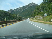
Interstate 93
through Franconia Notch
, New Hampshire
is also a notable exception being a super two
parkway with a speed limit of 45 miles per hour.
Interstate 35E
through Saint Paul
, Minnesota
is an example of a freeway that was not grandfathered into the system that is nonetheless an exception to standards. The freeway was not opened until 1990, has a speed limit of 45 MPH, and does not allow vehicles weighing over 9,000 pounds GVW. This is due to a number of lawsuits from wealthy surrounding homeowners, which heavily delayed and modified the project dating to the 1960s.
American Association of State Highway and Transportation Officials
AASHTO, the American Association of State Highway and Transportation Officials, is a standards setting body which publishes specifications, test protocols and guidelines which are used in highway design and construction throughout the United States...
(AASHTO) in the publication A Policy on Design Standards - Interstate System. For a certain highway
Highway
A highway is any public road. In American English, the term is common and almost always designates major roads. In British English, the term designates any road open to the public. Any interconnected set of highways can be variously referred to as a "highway system", a "highway network", or a...
to be considered an Interstate, it must meet these construction requirements or obtain a waiver
Waiver
A waiver is the voluntary relinquishment or surrender of some known right or privilege.While a waiver is often in writing, sometimes a person's actions can act as a waiver. An example of a written waiver is a disclaimer, which becomes a waiver when accepted...
from the Federal Highway Administration
Federal Highway Administration
The Federal Highway Administration is a division of the United States Department of Transportation that specializes in highway transportation. The agency's major activities are grouped into two "programs," the Federal-aid Highway Program and the Federal Lands Highway Program...
.
Standards
These standards are, , as follows:- Controlled access: All access onto and off the roadway is to be controlled with interchangesInterchange (road)In the field of road transport, an interchange is a road junction that typically uses grade separation, and one or more ramps, to permit traffic on at least one highway to pass through the junction without directly crossing any other traffic stream. It differs from a standard intersection, at which...
and grade separationGrade separationGrade separation is the method of aligning a junction of two or more transport axes at different heights so that they will not disrupt the traffic flow on other transit routes when they cross each other. The composition of such transport axes does not have to be uniform; it can consist of a...
s (including railroad crossings). See List of gaps in Interstate Highways for the few cases that violate this rule. Interchanges should provide full access; ramps are to be designed with the appropriate standards in mind. Minimum interchange spacing should be 1 mi (1.6 km) in urban areaUrban areaAn urban area is characterized by higher population density and vast human features in comparison to areas surrounding it. Urban areas may be cities, towns or conurbations, but the term is not commonly extended to rural settlements such as villages and hamlets.Urban areas are created and further...
s and 3 mi (4.8 km) in rural areas; collector/distributor roads or other configurations that reduce weaving can be used in urban areas to shorten this distance.- Access control (from adjacent properties) should extend at least 100 feet (30.5 m) in urban areas and 300 feet (91.4 m) in rural areas in each direction along the crossroad from the ramps.
- Minimum design speedDesign speedThe design speed is a tool used to determine geometric features of a new road during road design. The design speed chosen for a highway is a major factor in choosing superelevation rates and radii of curves, sight distance, and the lengths of crest and sag vertical curves...
: Minimum design speed of 75 mi/h in rural areas, with 65 mi/h acceptable in rolling terrainHillA hill is a landform that extends above the surrounding terrain. Hills often have a distinct summit, although in areas with scarp/dip topography a hill may refer to a particular section of flat terrain without a massive summit A hill is a landform that extends above the surrounding terrain. Hills...
, and as low as 50 mi/h allowed in mountainMountainImage:Himalaya_annotated.jpg|thumb|right|The Himalayan mountain range with Mount Everestrect 58 14 160 49 Chomo Lonzorect 200 28 335 52 Makalurect 378 24 566 45 Mount Everestrect 188 581 920 656 Tibetan Plateaurect 250 406 340 427 Rong River...
ous and urban areaUrban areaAn urban area is characterized by higher population density and vast human features in comparison to areas surrounding it. Urban areas may be cities, towns or conurbations, but the term is not commonly extended to rural settlements such as villages and hamlets.Urban areas are created and further...
s. However, speed limits as low as 40 mi/h are occasionally encountered, generally on pre-existing freeways that were grandfathered into the system.- Sight distance, curvatureCurvatureIn mathematics, curvature refers to any of a number of loosely related concepts in different areas of geometry. Intuitively, curvature is the amount by which a geometric object deviates from being flat, or straight in the case of a line, but this is defined in different ways depending on the context...
and superelevation according to the current edition of AASHTO's A Policy on Geometric Design of Highways and Streets for the design speed.
- Sight distance, curvature
- Maximum grade: Maximum grade is determined by a table, with up to 6% allowed in mountainous areas and hilly urban areas.
- Minimum number of lanes: At least two laneLaneA lane is a part of the roadway within a road marked out for use by a single line of vehicles in such a way as to control and guide drivers for the purpose of reducing traffic conflicts. Most public roads have at least two lanes, one for traffic in each direction, separated by Lane markings...
s in each direction, and more if necessary for an acceptable level of serviceLevel of serviceLevel of service is a measure used by traffic engineers to determine the effectiveness of elements of transportation infrastructure. LOS is most commonly used to analyze highways by categorizing traffic flow with corresponding safe driving conditions...
in the design year, according to the current edition of AASHTO's A Policy on Geometric Design of Highways and Streets. Climbing laneClimbing laneClimbing lanes are a roadway lane design typically used on Interstate highways. They allow slower travel for large vehicles, such as large trucks or Semi-trailer trucks, up a steep grade...
s and emergency escape rampsRunaway truck rampA runaway truck ramp, runaway truck lane, emergency escape ramp or truck arrester bed is a traffic device that enables vehicles that are having braking problems to safely stop. It is typically a long, sand or gravel-filled lane adjacent to a road with a steep grade, and is designed to accommodate...
should be provided where appropriate. - Minimum lane width: Minimum lane width of 12 feet (3.66 m).
- Shoulder width: Minimum outside paved shoulder width of 10 feet (3.05 m) and inside shoulder width of 4 feet (1.22 m). With three or more lanes in each direction, the inside paved shoulder should be at least 10 feet (3.05 m) wide. If truck traffic is over 250 Directional Design Hour Volume, shoulders at least 12 feet (3.66 m) wide should be considered. In mountainous terrain, 8 feet (2.44 m) outside and 4 feet (1.22 m) inside shoulders are acceptable, except when there are at least four lanes in each direction, in which case the inside shoulders should also be 8 feet (2.44 m) wide.
- Pavement sloping: Pavement cross slopeCross slopeCross slope is a geometric feature of pavement surfaces; the transversal slope [%] with respect to the horizon. It is a very important safety factor. One task is to make water run off the surface to a drainage system, as Cross Slope is the main contributor to Pavement Drainage gradient. Very low...
of at least 1.5% and preferably 2% to ensure proper drainageDrainageDrainage is the natural or artificial removal of surface and sub-surface water from an area. Many agricultural soils need drainage to improve production or to manage water supplies.-Early history:...
on straight sections. This can be increased to 2.5% in areas of heavy rainfall. Shoulder cross slope should be between 2% and 6% but not less than the main lanes.- Land slopes within the clear zone should be at most 4:1 and preferably 6:1 or flatter. Roadside barriers should be used for slopes of 3:1 or steeper, in accordance with the current edition of AASHTO's Roadside Design Guide.
- Median width: Minimum median width of 36 feet (11 m) in rural areas, and 10 feet (3 m) in urban or mountainous areas. To prevent median-crossing accidents, guard railGuard railGuard rail or guardrail, sometimes referred to as guide rail or railing, is a system designed to keep people or vehicles from straying into dangerous or off-limits areas...
or Jersey barrierJersey barrierA Jersey barrier or Jersey wall is a modular concrete barrier employed to separate lanes of traffic. It is designed to both minimize vehicle damage in cases of incidental contact while still preventing crossover in the case of head-on accidents....
should be installed in medians in accordance with the current edition of AASHTO's Roadside Design Guide, based on traffic, median width and crash history. When possible, median openings between parallel bridges less than 30 feet (9.14 m) in width should be decked over; otherwise barriers or guard rails should be installed to exclude vehicles from the gap. - Recovery areas: No fixed objects should be in the clear recovery area, determined by the design speed in accordance with the current edition of AASHTO's Roadside Design Guide. When this is not possible, breakaway supports or barriers guarding the objects shall be used.
- Curb slope: Vertical curbCurb (road)A curb, or kerb , is the edge where a raised pavement/sidewalk/footpath, road median, or road shoulder meets an unraised street or other roadway.-Function:...
s are prohibited. Sloping curbs are to be at the edge of the paved shoulder, with a maximum height of 100 millimetres (3.9 in). The combination of curbs and guard railGuard railGuard rail or guardrail, sometimes referred to as guide rail or railing, is a system designed to keep people or vehicles from straying into dangerous or off-limits areas...
is discouraged; in this case the guard rail should be closer to the road than the curb. - Vertical clearance: Minimum vertical clearanceClearanceA clearance can refer to:* in chess, A positional move, where a player moves a piece occupying a certain square away, replacing it with an allied piece that will strengthen the player's position....
under overhead structures (including over the paved shoulders) of 16 feet (4.88 m) in rural areas and 14 feet (4.27 m) in urban areaUrban areaAn urban area is characterized by higher population density and vast human features in comparison to areas surrounding it. Urban areas may be cities, towns or conurbations, but the term is not commonly extended to rural settlements such as villages and hamlets.Urban areas are created and further...
s, with allowance for extra layers of pavementPavement (material)Road surface or pavement is the durable surface material laid down on an area intended to sustain vehicular or foot traffic, such as a road or walkway. In the past cobblestones and granite setts were extensively used, but these surfaces have mostly been replaced by asphalt or concrete. Such...
. Through urban areas at least one routing should have 16 feet (4.88 m) clearances. Sign supports and pedestrian overpasses must be at least 17 feet (5.18 m) above the road, except on urban routes with lesser clearance, where they should be at least 1 ft (0.3 m) higher than other objects. - Horizontal clearance: under or along a bridge shall be the full paved width of the rest of the road. Bridges longer than 200 feet (61 m) can be narrower, with a minimum of 4 feet (1.22 m) on both sides of the travel lanes.
- Bridge strength: New bridges are to have at least MS 18 (HS-20) structural capacity. Weaker bridges that can continue to serve the route for 20 more years are allowed to remain.
- Additionally, existing bridges can remain if they have at least 12 feet (3.66 m) lanes with 10 feet (3.05 m) outside and 3.5 feet (1.07 m) inside shoulders. Long bridges are to have at least 3.5 feet (1.07 m) on each side of the travel lanes; bridge railing should be upgraded to current standards if necessary.
- Tunnel clearance: TunnelTunnelA tunnel is an underground passageway, completely enclosed except for openings for egress, commonly at each end.A tunnel may be for foot or vehicular road traffic, for rail traffic, or for a canal. Some tunnels are aqueducts to supply water for consumption or for hydroelectric stations or are sewers...
s should in theory be equivalent to long overcrossings, but because of cost the standards can be reduced. Vertical clearance is the same as under bridges, including the provision for alternate routing. Width should be at least 44 feet (13.41 m), which consists of two 12 feet (3.66 m) lanes, 10 feet (3.05 m) outside and 5 feet (1.52 m) inside shoulders, and 2.5 foot (0.762 m) safety walkways on each side. If necessary to meet the dimensions of the approach, this can be shifted left or right. A reduced width is acceptable due to high cost. In this case, the minimum width is 30 feet (9.14 m), with at least 2 foot (0.6096 m) more than the approach for the sum of the shoulder widths, but at least 24 feet (7.32 m) total, and at least 1.5 foot (0.4572 m) on each side for a safety walkway. If there is no safety walkway, a 3 foot (0.9144 m) offset with a "safety shape" in the wall is acceptable.
Exceptions
The standards have been changed over the years, resulting in many older Interstates not conforming to the current standards, and yet others are not built to standards because to do so would be too costly or environmentally unsound.Grandfather clause
Grandfather clause is a legal term used to describe a situation in which an old rule continues to apply to some existing situations, while a new rule will apply to all future situations. It is often used as a verb: to grandfather means to grant such an exemption...
into the system. Most of these were toll road
Toll road
A toll road is a privately or publicly built road for which a driver pays a toll for use. Structures for which tolls are charged include toll bridges and toll tunnels. Non-toll roads are financed using other sources of revenue, most typically fuel tax or general tax funds...
s that were built before the Interstate system came into existence or were under construction at the time President
President of the United States
The President of the United States of America is the head of state and head of government of the United States. The president leads the executive branch of the federal government and is the commander-in-chief of the United States Armed Forces....
Dwight D. Eisenhower
Dwight D. Eisenhower
Dwight David "Ike" Eisenhower was the 34th President of the United States, from 1953 until 1961. He was a five-star general in the United States Army...
signed the Federal Aid Highway Act of 1956
Federal Aid Highway Act of 1956
The Federal-Aid Highway Act of 1956, popularly known as the National Interstate and Defense Highways Act , was enacted on June 29, 1956, when Dwight D. Eisenhower signed the bill into law...
. The most notable example is the Pennsylvania Turnpike
Pennsylvania Turnpike
The Pennsylvania Turnpike is a toll highway system operated by the Pennsylvania Turnpike Commission in the Commonwealth of Pennsylvania, United States. The three sections of the turnpike system total . The main section extends from Ohio to New Jersey and is long...
, which originally had a very narrow median that later required the installation of a Jersey barrier
Jersey barrier
A Jersey barrier or Jersey wall is a modular concrete barrier employed to separate lanes of traffic. It is designed to both minimize vehicle damage in cases of incidental contact while still preventing crossover in the case of head-on accidents....
due to heavy traffic loads.
Interstate 93
Interstate 93
Interstate 93 is an Interstate Highway in the New England section of the United States. Its southern terminus is in Canton, Massachusetts, in the Boston metropolitan area, at Interstate 95; its northern terminus is near St. Johnsbury, Vermont, at Interstate 91...
through Franconia Notch
Franconia Notch
Franconia Notch is a major mountain pass through the White Mountains of New Hampshire. Dominated by Cannon Mountain, it lies principally within Franconia Notch State Park and is traversed by the Franconia Notch Parkway Franconia Notch (el. 1950 ft. / 590 m.) is a major mountain pass through...
, New Hampshire
New Hampshire
New Hampshire is a state in the New England region of the northeastern United States of America. The state was named after the southern English county of Hampshire. It is bordered by Massachusetts to the south, Vermont to the west, Maine and the Atlantic Ocean to the east, and the Canadian...
is also a notable exception being a super two
Super two
A super two, super two-lane highway or wide two lane is a two-lane surface road built to high standards, typically including partial control of access, occasional passing lanes and hard shoulders...
parkway with a speed limit of 45 miles per hour.
Interstate 35E
Interstate 35E (Minnesota)
Interstate 35E is an Interstate Highway in the U.S. state of Minnesota, passing through downtown Saint Paul. It is one of two through routes for Interstate 35 through the Twin Cities of Minneapolis and Saint Paul, the other being Interstate 35W through Minneapolis. Thus, both ends of I-35E are...
through Saint Paul
Saint Paul, Minnesota
Saint Paul is the capital and second-most populous city of the U.S. state of Minnesota. The city lies mostly on the east bank of the Mississippi River in the area surrounding its point of confluence with the Minnesota River, and adjoins Minneapolis, the state's largest city...
, Minnesota
Minnesota
Minnesota is a U.S. state located in the Midwestern United States. The twelfth largest state of the U.S., it is the twenty-first most populous, with 5.3 million residents. Minnesota was carved out of the eastern half of the Minnesota Territory and admitted to the Union as the thirty-second state...
is an example of a freeway that was not grandfathered into the system that is nonetheless an exception to standards. The freeway was not opened until 1990, has a speed limit of 45 MPH, and does not allow vehicles weighing over 9,000 pounds GVW. This is due to a number of lawsuits from wealthy surrounding homeowners, which heavily delayed and modified the project dating to the 1960s.
External links
- AASHTO Bookstore - A Policy on Design Standards - Interstate System (ISBN 1560512911)