
California State Route 56
Encyclopedia
State Route 56 runs from Interstate 5 in the Carmel Valley neighborhood of San Diego to Interstate 15. Route 56 was originally planned in 1964 to connect to the north end of State Route 125 and continue east to State Route 67, but the city of Poway
worked to make sure that would not be possible. Therefore, the eastern terminus of SR 56 is also the western end of the Ted Williams Parkway. Route 56 is also called the Ted Williams Freeway (thus, both are named after baseball
player Ted Williams
, who was born in San Diego).
.
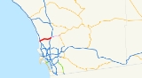
SR 56 begins as a ramp from I-5
northbound. The interchange is considerably complex; from I-5 southbound one must exit to Carmel Valley Road before entering SR 56. The route then has an exit at Carmel Creek Road, which provides access to the nearby San Diego Jewish Academy
, heading eastward through a residential area. After passing milepost 2, the freeway has a similar interchange with Carmel Country Road south of the community of Torrey Hills. SR 56 meets Carmel Valley Road, and curves northward, passing by Canyon Crest Academy
before turning southeastward. The route passes over McGonigle Creek before intersecting Camino Del Sur, which provides access to the nearby Westview High School
. Southeast of Camino Del Sur, SR 56 curves back east, passing under Carmel Mountain Road without an exit. The route meets an exit with Black Mountain Road and Rancho Penasquitos Boulevard in Rancho Penasquitos in a primarily residential area before meeting its terminus at I-15
. Past the bridge over I-15, the road continues as Ted Williams Parkway.
, ran from LRN 2, which is now US 101, all the way east to LRN 198, which is now SR 67.
Ted Williams, who the freeway is named after, was a baseball player born in San Diego. He played for the Boston Red Sox
during his 21-year career. The freeway was officially named after Ted Williams in 1993.
The segments of the freeway from I-5 to Carmel Valley Rd and from Black Mountain Rd to I-15 were built first, opening to traffic in 1994. A 5 miles (8 km) gap in the freeway remained until 2003. At that time, a section on the east end from Black Mountain Rd to Camino Del Sur opened, but it took until July 19, 2004, to join the west and east ends of the freeway. Significant portions of the road remain under construction, including the ramps to I-15, and the ramps to I-5. Until this construction is completed, traffic is routed along local streets through Carmel Valley.
The cost of completing the middle 5.5 miles (8.9 km) segment was reported at $220 million in 2004. SANDAG started a study about the I-5 connector ramps in 2004, which is projected to be completed in 2012.
The entire route is in San Diego
, San Diego County
.
{| class=wikitable
!Postmile
!Exit
!Destinations
!Notes
|-
|0.00
|1A
|
|Westbound exit and eastbound entrance
|-
|0.31
|1B
|.svg.png) El Camino Real
El Camino Real
to I-5
north
|Westbound exit and eastbound entrance
|-
|0.82
|1C
|Carmel Creek Road
|Signed as exit 1 eastbound
|-
|1.81
|2
|Carmel Country Road
|
|-
|3.10
|3
|Carmel Valley Road
|
|-
|6.07
|6
|Camino del Sur
|
|-
|7.23
|7
|Black Mountain Road
|
|-
|8.04
|8
|Rancho Peñasquitos Boulevard
|Connects to CR S4
|-
|colspan=4 align=center|East end of freeway
|-
|9.21
|9
|
|Interchange; east end of state maintenance; no exit number westbound
|-
|
|
|Sabre Springs Parkway, Rancho Carmel Drive
|Interchange
|-
|
|
|Ted Williams Parkway
|Continuation beyond I-15
Poway, California
Poway is a city in San Diego County, California. Originally an unincorporated community in San Diego County, Poway officially became a city in December 1980. Even though Poway lies geographically in the middle of San Diego County, most consider its relative location as north county inland...
worked to make sure that would not be possible. Therefore, the eastern terminus of SR 56 is also the western end of the Ted Williams Parkway. Route 56 is also called the Ted Williams Freeway (thus, both are named after baseball
Baseball
Baseball is a bat-and-ball sport played between two teams of nine players each. The aim is to score runs by hitting a thrown ball with a bat and touching a series of four bases arranged at the corners of a ninety-foot diamond...
player Ted Williams
Ted Williams
Theodore Samuel "Ted" Williams was an American professional baseball player and manager. He played his entire 21-year Major League Baseball career as the left fielder for the Boston Red Sox...
, who was born in San Diego).
Route description
This route is part of the California Freeway and Expressway SystemCalifornia Freeway and Expressway System
The California Freeway and Expressway System is a system of existing or planned freeways and expressways in the U.S. state of California. It is defined by the Streets and Highways Code.-List of roads in the system:*State Route 1 *State Route 2...
.
SR 56 begins as a ramp from I-5
Interstate 5
Interstate 5 is the main Interstate Highway on the West Coast of the United States, running largely parallel to the Pacific Ocean coastline from Canada to Mexico . It serves some of the largest cities on the U.S...
northbound. The interchange is considerably complex; from I-5 southbound one must exit to Carmel Valley Road before entering SR 56. The route then has an exit at Carmel Creek Road, which provides access to the nearby San Diego Jewish Academy
San Diego Jewish Academy
The San Diego Jewish Academy is a private, independent Jewish day school currently located in the Carmel Valley community of San Diego, California...
, heading eastward through a residential area. After passing milepost 2, the freeway has a similar interchange with Carmel Country Road south of the community of Torrey Hills. SR 56 meets Carmel Valley Road, and curves northward, passing by Canyon Crest Academy
Canyon Crest Academy
Canyon Crest Academy is a public high school in San Diego, California. Founded in 2004, the school is a member of the San Dieguito Union High School District...
before turning southeastward. The route passes over McGonigle Creek before intersecting Camino Del Sur, which provides access to the nearby Westview High School
Westview High School (San Diego)
Westview High School is a public secondary school located in Torrey Highlands, a community of San Diego, California in the United States. It is part of the Poway Unified School District....
. Southeast of Camino Del Sur, SR 56 curves back east, passing under Carmel Mountain Road without an exit. The route meets an exit with Black Mountain Road and Rancho Penasquitos Boulevard in Rancho Penasquitos in a primarily residential area before meeting its terminus at I-15
Interstate 15
Interstate 15 is the fourth-longest north–south Interstate Highway in the United States, traveling through the states of California, Nevada, Arizona, Utah, Idaho, and Montana from San Diego to the Canadian border...
. Past the bridge over I-15, the road continues as Ted Williams Parkway.
History
The route was first added the California State Highway System in 1959 as Legislative Route Number 278 (LRN 278). The routing, along which a road was never built until after the 1964 state highway renumbering1964 state highway renumbering (California)
In 1963 and 1964, the California Division of Highways implemented a major renumbering of its state highways. The majority of sign routes — those marked for the public — kept their numbers; the main changes were to the legislative routes, which had their numbers changed to match the sign routes...
, ran from LRN 2, which is now US 101, all the way east to LRN 198, which is now SR 67.
Ted Williams, who the freeway is named after, was a baseball player born in San Diego. He played for the Boston Red Sox
Boston Red Sox
The Boston Red Sox are a professional baseball team based in Boston, Massachusetts, and a member of Major League Baseball’s American League Eastern Division. Founded in as one of the American League's eight charter franchises, the Red Sox's home ballpark has been Fenway Park since . The "Red Sox"...
during his 21-year career. The freeway was officially named after Ted Williams in 1993.
The segments of the freeway from I-5 to Carmel Valley Rd and from Black Mountain Rd to I-15 were built first, opening to traffic in 1994. A 5 miles (8 km) gap in the freeway remained until 2003. At that time, a section on the east end from Black Mountain Rd to Camino Del Sur opened, but it took until July 19, 2004, to join the west and east ends of the freeway. Significant portions of the road remain under construction, including the ramps to I-15, and the ramps to I-5. Until this construction is completed, traffic is routed along local streets through Carmel Valley.
The cost of completing the middle 5.5 miles (8.9 km) segment was reported at $220 million in 2004. SANDAG started a study about the I-5 connector ramps in 2004, which is projected to be completed in 2012.
Exit list
- Note: Except where prefixed with a letter, postmiles were measured in 1964, based on the alignment as it existed at that time, and do not necessarily reflect current mileage.
The entire route is in San Diego
San Diego, California
San Diego is the eighth-largest city in the United States and second-largest city in California. The city is located on the coast of the Pacific Ocean in Southern California, immediately adjacent to the Mexican border. The birthplace of California, San Diego is known for its mild year-round...
, San Diego County
San Diego County, California
San Diego County is a large county located in the southwestern corner of the US state of California. Hence, San Diego County is also located in the southwestern corner of the 48 contiguous United States. Its county seat and largest city is San Diego. Its population was about 2,813,835 in the 2000...
.
{| class=wikitable
!Postmile
!Exit
Exit number
An exit number is a number assigned to a road junction, usually an exit from a freeway. It is usually marked on the same sign as the destinations of the exit, as well as a sign in the gore....
!Destinations
!Notes
|-
|0.00
|1A
|
|Westbound exit and eastbound entrance
|-
|0.31
|1B
|
El Camino Real (California)
El Camino Real and sometimes associated with Calle Real usually refers to the 600-mile California Mission Trail, connecting the former Alta California's 21 missions , 4 presidios, and several pueblos, stretching from Mission San Diego de Alcalá in San Diego...
to I-5
Interstate 5 in California
Interstate 5 is a major north–south route of the Interstate Highway System in the U.S. state of California. It begins at the Mexico – United States border at the San Ysidro crossing, goes north across the length of California and crosses into Oregon south of the Medford-Ashland metropolitan...
north
|Westbound exit and eastbound entrance
|-
|0.82
|1C
|Carmel Creek Road
|Signed as exit 1 eastbound
|-
|1.81
|2
|Carmel Country Road
|
|-
|3.10
|3
|Carmel Valley Road
|
|-
|6.07
|6
|Camino del Sur
|
|-
|7.23
|7
|Black Mountain Road
|
|-
|8.04
|8
|Rancho Peñasquitos Boulevard
|Connects to CR S4
|-
|colspan=4 align=center|East end of freeway
|-
|9.21
|9
|
|Interchange; east end of state maintenance; no exit number westbound
|-
|
|
|Sabre Springs Parkway, Rancho Carmel Drive
|Interchange
|-
|
|
|Ted Williams Parkway
|Continuation beyond I-15