
.gif)
Interstate 405 (California)
Encyclopedia
Interstate 405 is a major north–south Interstate Highway
in Southern California
. It is a bypass
of Interstate 5
, running along the western areas of the Greater Los Angeles Area
from Irvine
in the south to near San Fernando
in the north. The entire route is known as the northern segment of the San Diego Freeway
.
I-405 is a heavily-traveled thoroughfare by commuters and freight haulers along its entire length and has earned its place as the busiest and most congested freeway in the United States. The freeway's annual average daily traffic
between exits 21 and 22 in Seal Beach
reached 374,000 in 2008, making it the highest count in the nation. It has played a crucial role in the development of dozens of cities and suburb
s along its route through the Greater Los Angeles area.
This route is part of the California Freeway and Expressway System
.
interchange with Interstate 5 in southeastern Irvine
. It then runs northwest through Orange County
to Long Beach
in Los Angeles County
. The freeway then roughly follows the outline of the Pacific
coast, varying between five and ten miles (16 km) inland before crossing over the Sepulveda Pass
in the Santa Monica Mountains
. I-405 next travels northerly through the San Fernando Valley
, before terminating with I-5 in the Mission Hills
district of Los Angeles.
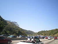
 The San Diego Freeway's congestion problems are legendary, leading jokes that the Interstate was numbered 405 because traffic moves at "four or five" miles per hour, or because drivers need "four or five" hours to get anywhere. Indeed, average speeds as low as 5 mph are routinely recorded during morning and afternoon commutes, and its interchanges with the Ventura Freeway
(U.S. Route 101) and with the Santa Monica Freeway (Interstate 10
) each consistently rank among the five most congested freeway interchanges in the United States. As a result of these congestion problems, it may take longer to pass through the entire Los Angeles area
using this bypass route instead of merely taking the primary route I-5 through the city.
Commuters are known to despise the freeway. Steve Harvey of the Los Angeles Times
once featured a personalized license plate with the text HATE405 in his column. While much of this gridlock has to do with the lack of alternate routes between many of the areas it connects — some of which, such as the Pacific Coast and Laurel Canyon freeways, were proposed but abandoned for political reasons.
in Orange County
, Long Beach Municipal Airport
and Los Angeles International Airport
. With connections, it is also very close to the Port of Long Beach
and the Port of Los Angeles
.
The route also passes by or through many recreation and commercial destinations. These include more than ten California state beaches, several other beaches owned by counties and municipalities, many of the beach cities favored by tourists, as well as Century City
and Marina del Rey
.
Some of the educational institutions it passes include the California state universities
at Dominguez Hills
, Long Beach
, and Northridge
; the University of California
at Irvine
and UCLA
, Loyola Marymount University
, and Pepperdine University
's West LA and Irvine campuses. I-405 also passes cultural facilities such as the Getty Center
and the Skirball Cultural Center
.

 I-405 was approved as a chargeable interstate in 1955. Construction began in 1957 with the first section, mostly north of LAX Airport
being completed in 1961 (signed as SR 7) followed by sections west of Interstate 605
within the following few years. The final section covering most of Orange County
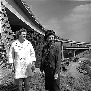
opened in 1969. Construction required the already existing Mulholland Highway
to be re-routed 1.1 miles to the south along a new 579-foot-long bridge, the Mulholland Drive Bridge, to span Interstate 405.
The freeway from present-day I-10
to I-5
near San Fernando
was once known as the "Sepulveda Freeway" as it was named for Sepulveda Boulevard
.
and associated changes to freeway entrances, exits, and underpasses along a 10-mile stretch through the Sepulveda Pass
between I-10 and U.S. 101/Ventura Boulevard. The project is to completed as a design-build
in contrast to the traditional design-bid-build
used typically in infrastructure improvement. This section of I-405 was closed for a weekend in July 2011 to demolish the Mulholland Drive Bridge
(See 'Carmageddon' bellow).
to provide a new southbound on-ramp and a new northbound off-ramp for Arbor Vitae Street, to reconstruct and widened the Arbor Vitae Street over-bridge and replace the Century Boulevard overcrossing structure. This work would reduce congestion on the approach to Los Angeles International Airport
. The California Department of Transportation
has not issued a start date for this work.
is currently studying a proposal to add a HOT lane between Highway 73 in Costa Mesa and I-605 in Seal Beach.
game, USC was voted into the Rose Bowl despite the UCLA team's having defeated the Trojans -- with both teams having only one loss during the season. UCLA students protested by blocking the freeway's northbound lanes at Wilshire Boulevard.
star O.J. Simpson, suspected in the murder of his ex-wife Nicole Brown Simpson
and waiter Ronald Goldman
, took to the freeway in a white Ford Bronco
(driven by former USC
teammate Al Cowlings
) with police in pursuit. A bizarre, widely televised low-speed chase ensued and ended hours later when Simpson returned to his Brentwood
estate via the Sunset Boulevard
exit and surrendered to law enforcement.
, the only son of Bill Cosby
, was murdered along I-405 in Los Angeles on January 16, 1997, while fixing a flat tire.
and the Apocalypse
, since it was anticipated that the closure would severely impact traffic.
In reality traffic was lighter than normal across a wide area. California Department of Transportation reported that fewer vehicles used the roads than usual, and those who did travel by road arrived more quickly than on a normal weekend. The Metrolink
commuter train system recorded its highest-ever weekend ridership since it began operating in 1991. Ridership was 50% higher than the same weekend in 2010, and 10% higher than the previous weekend ridership record, which occurred during the U2 360° Tour
in June 2011. In response to an airline's offer of flights special flights between Bob Hope Airport
in Burbank and Long Beach Airport, a distance
of only 29 mi (47 km), for $4. a group of cyclists did the same journey in one and a half hours, compared to two and a half hours by plane (including a drive to the airport from West Hollywood 90 minutes in advance of the flight). There was also some debate about where the Los Angeles area could benefit from car-free weekends on a regular basis.
{| class=wikitable
!County
!Location
!Postmile
!Exit
!Destinations
!Notes
|-
|rowspan=28|Orange
ORA 0.23-24.18
|rowspan=10|Irvine
|bgcolor=#ffdddd|0.23
|bgcolor=#ffdddd|
|bgcolor=#ffdddd|
|bgcolor=#ffdddd|Southbound exit and northbound entrance; former US 101 south
|-bgcolor=#ffdddd
|
|1A
|Lake Forest Drive
|Southbound exit and northbound entrance
|-bgcolor=#ffdddd
|
|1B
|Bake Parkway
|Southbound exit and northbound entrance
|-
|0.95
|1C
|Irvine Center Drive
|Signed as exit 1 northbound
|-bgcolor=#ffdddd
|1.80
|2
|
|No northbound exit to SR 133 north
|-
|2.88
|3
|Shady Canyon Drive, Sand Canyon Avenue
|
|-
|3.95
|4
|Jeffrey Road, University Drive
|
|-
|5.62
|5
|Culver Drive
|
|-
|6.92
|7
|Jamboree Road
|
|-
|7.80
|8
|MacArthur Boulevard – John Wayne Airport
|
|-
|rowspan=7|Costa Mesa
|bgcolor=#ffdddd|8.74
|bgcolor=#ffdddd|9A
|bgcolor=#ffdddd|
|bgcolor=#ffdddd|No southbound exit to SR 55 south and northbound entrance from SR 55 north
|-
|9.51
|9B
|Bristol Street
|
|-bgcolor=#ffdddd
|
|9B
|Anton Boulevard, Avenue of the Arts
|Northbound exit and entrance
|-bgcolor=#ffdddd
|10.28
|10
| via toll road
|Southbound exit and northbound entrance
|-bgcolor=#ffdddd
|
|11
|South Coast Drive
|Northbound exit only
|-
|10.75
|11A
|Fairview Road
|Signed as exit 11 northbound
|-
|11.45
|11B
|Harbor Boulevard
– Costa Mesa
|Signed as exit 11 northbound
|-
|rowspan=3|Fountain Valley
|12.47
|12
|Euclid Street, Newhope Street
|
|-
|13.78
|14
|Brookhurst Street – Fountain Valley
|
|-bgcolor=#ffdddd
|14.82
|15A
|Warner Avenue east
|Southbound exit and northbound entrance
|-
|rowspan=2|Huntington Beach
|15.21
|15B
|Magnolia Street, Warner Avenue west
|Signed as exit 15 northbound
|-
|16.54
|16
|
|
|-
|rowspan="3"|Westminster
|17.75
|18
|Bolsa Avenue, Goldenwest Street
|Goldenwest Street is signed as Golden West Street
|-
|19.16
|19
|Westminster Avenue, Springdale Street
|
|-bgcolor=#ddffdd
|20.75
|21
|
|South end of SR 22 overlap
|-
|rowspan=3|Seal Beach
|22.64
|22
|Seal Beach Boulevard, Los Alamitos Boulevard
|Former SR 35
|-bgcolor=#ddffdd
|23.28
|23
|
|North end of SR 22 overlap
|-
|24.04
|24A
|
|Signed as exit 24 northbound
|-
|rowspan=61|Los Angeles
LA 0.27-48.64
|rowspan=6|Long Beach
|bgcolor=#ffdddd|0.45
|bgcolor=#ffdddd|24B
|bgcolor=#ffdddd|Studebaker Road
|bgcolor=#ffdddd|Southbound exit and northbound entrance
|-
|1.11
|25
|Palo Verde Avenue
|
|-bgcolor=#ffdddd
|1.64
|26A
|Woodruff Avenue
|No southbound exit
|-
|2.18
|26B
|Bellflower Boulevard
|Signed as exit 26 southbound
|-
|3.32
|27
|
|
|-
|4.88
|29
|Spring Street, Cherry Avenue – Signal Hill
|Signed as exits 29A (south) and 29B (north)
|-
|Signal Hill
|5.39
|29C
|Orange Avenue
|
|-
|rowspan=5|Long Beach
|6.08
|30A
|Atlantic Avenue
|
|-
|6.34
|30B
|Long Beach Boulevard
|Former SR 15
|-bgcolor=#ffdddd
|6.70
|32A
|Pacific Avenue
|Southbound exit and northbound entrance
|-
|7.60
|32
|
|Signed as exits 32A (north) and 32B (south) northbound, and 32B (south) and 32C (north) southbound
|-
|8.06
|32C
|Hughes Way, Santa Fe Avenue
|Signed as exit 32D southbound
|-
|rowspan=6|Carson
|8.78
|33A
|Alameda Street (SR 47
south)
|
|-
|9.56
|33B
|Wilmington Avenue
|
|-
|10.54
|34
|Carson Street
|
|-
|11.22
|35
|Avalon Boulevard
– Carson
|Northbound exit to Avalon Boulevard south is via exit 34
|-bgcolor=#ffdddd
|12.60
|36
|Main Street
|Northbound exit and southbound entrance
|-
|12.97
|37A
|
|Signed as exit 37 northbound; former US 6
|-
|rowspan=3|Los Angeles
|bgcolor=#ffdddd|13.28
|bgcolor=#ffdddd|37B
|bgcolor=#ffdddd|Vermont Avenue
|bgcolor=#ffdddd|Southbound exit and northbound entrance
|-
|13.83
|38A
|Normandie Avenue
– Gardena
|
|-
|14.40
|38B
|Western Avenue
|
|-
|rowspan=3|Torrance
|15.45
|39
|Crenshaw Boulevard – Torrance
|
|-
|16.57
|40A
|Artesia Boulevard
|Northbound exit to Artesia Boulevard east is via exit 39, southbound exit to Artesia Boulevard west is via exit 40B; former SR 91
|-bgcolor=#ffdddd
|16.88
|40B
|Redondo Beach Boulevard
|Southbound exit and northbound entrance
|-
|rowspan=2|Lawndale
|17.59
|42A
|
|
|-
|18.23
|42B
|Inglewood Avenue
|
|-
|rowspan=2|Hawthorne
|19.21
|43
|Rosecrans Avenue – Manhattan Beach
|Signed as exits 43A (east) and 43B (west) southbound
|-
|20.22
|44
|El Segundo Boulevard
– El Segundo
|
|-
|rowspan=2|Los Angeles
|R21.18
|45A
|
|Signed as exit 45 southbound; serves Los Angeles International Airport
|-
|R21.22
|45B
|Imperial Highway
|Southbound exit is part of exit 46
|-
|rowspan=2|Inglewood
|22.22
|46
|Century Boulevard – LAX Airport
|
|-
|23.36
|47
|Manchester Boulevard, La Cienega Boulevard
, Florence Avenue
|Manchester Boulevard was former SR 42
|-
|rowspan=2|Los Angeles
|24.27
|48
|La Tijera Boulevard
|
|-
|24.56
|49A
|Howard Hughes Parkway, Sepulveda Boulevard
|Signed as exit 49 southbound
|-
|rowspan=5|Culver City
|bgcolor=#ffdddd|25.46
|bgcolor=#ffdddd|49B
|bgcolor=#ffdddd|Sepulveda Boulevard
, Slauson Avenue
(SR 90
east)
|bgcolor=#ffdddd|Northbound exit only
|-
|25.95
|50A
|Jefferson Boulevard
|Signed as exit 50B northbound
|-
|25.95
|50B
|
|Signed as exit 50A northbound
|-
|27.20
|51
|Culver Boulevard, Washington Boulevard
– Culver City
|
|-
|27.96
|52
|Venice Boulevard (SR 187), Washington Boulevard
|
|-
|rowspan=22|Los Angeles
|bgcolor=#ffdddd|29.16
|bgcolor=#ffdddd|53A
|bgcolor=#ffdddd|National Boulevard
|bgcolor=#ffdddd|Northbound exit and southbound entrance
|-
|29.54
|53B
|
|Signed as exit 53 southbound
|-bgcolor=#ffdddd
|30.18
|54
|Olympic Boulevard
, Pico Boulevard
|Southbound exit and northbound entrance; former SR 26
|-
|30.86
|55A
|
|Former US 66
|-
|31.54
|55B
|Wilshire Boulevard
|Signed as exits 55B (east) and 55C (west) southbound
|-bgcolor=#ffdddd
|32.50
|56
|Montana Avenue
|Northbound exit only
|-
|33.00
|57A
|Sunset Boulevard
|Signed as exit 57 southbound
|-bgcolor=#ffdddd
|33.29
|57B
|Moraga Drive
|Northbound exit and entrance
|-
|34.76
|59
|Getty Center Drive
|
|-
|36.03
|61
|Mulholland Drive
, Skirball Center Drive
|
|-
|39.00
|63A
|Ventura Boulevard
, Sepulveda Boulevard
, Valley Vista Boulevard
|
|-
|39.43
|63B
|
|
|-
|40.29
|64
|Burbank Boulevard
|
|-
|41.36
|65
|Victory Boulevard
– Van Nuys
|
|-
|42.36
|66
|Sherman Way
|Signed as exits 66A (east) and 66B (west) northbound
|-
|43.76
|68
|Roscoe Boulevard – Panorama City
|
|-
|44.74
|69
|Nordhoff Street
|
|-
|46.24
|70
|Devonshire Street – Granada Hills
|
|-bgcolor=#ffdddd
|46.85
|71A
|
|Signed as exit 71 southbound; no southbound exit to SR 118 east or northbound entrance from SR 118 west
|-bgcolor=#ffdddd
|47.24
|71B
|San Fernando Mission Boulevard – San Fernando
|Northbound exit and southbound entrance
|-
|47.75
|72
|Rinaldi Street – Mission Hills
|
|-bgcolor=#ffdddd
|48.64
|
|
|Northbound exit and southbound entrance
Interstate Highway System
The Dwight D. Eisenhower National System of Interstate and Defense Highways, , is a network of limited-access roads including freeways, highways, and expressways forming part of the National Highway System of the United States of America...
in Southern California
Southern California
Southern California is a megaregion, or megapolitan area, in the southern area of the U.S. state of California. Large urban areas include Greater Los Angeles and Greater San Diego. The urban area stretches along the coast from Ventura through the Southland and Inland Empire to San Diego...
. It is a bypass
Bypass (road)
A bypass is a road or highway that avoids or "bypasses" a built-up area, town, or village, to let through traffic flow without interference from local traffic, to reduce congestion in the built-up area, and to improve road safety....
of Interstate 5
Interstate 5 in California
Interstate 5 is a major north–south route of the Interstate Highway System in the U.S. state of California. It begins at the Mexico – United States border at the San Ysidro crossing, goes north across the length of California and crosses into Oregon south of the Medford-Ashland metropolitan...
, running along the western areas of the Greater Los Angeles Area
Greater Los Angeles Area
The Greater Los Angeles Area, or the Southland, is a term used for the Combined Statistical Area sprawled over five counties in the southern part of California, namely Los Angeles County, Orange County, San Bernardino County, Riverside County and Ventura County...
from Irvine
Irvine, California
Irvine is a suburban incorporated city in Orange County, California, United States. It is a planned city, mainly developed by the Irvine Company since the 1960s. Formally incorporated on December 28, 1971, the city has a population of 212,375 as of the 2010 census. However, the California...
in the south to near San Fernando
San Fernando, California
San Fernando is a city located in the San Fernando Valley, in northwestern region of Los Angeles, California, United States. The population was 23,645 at the 2010 census, up from 23,564 at the 2000 census.-History:...
in the north. The entire route is known as the northern segment of the San Diego Freeway
San Diego Freeway
The San Diego Freeway is a named freeway in Southern California. It refers to the following two segments:*Interstate 5 in California, from the Mexico – United States border at the San Ysidro district of San Diego to Interstate 405 in Irvine...
.
I-405 is a heavily-traveled thoroughfare by commuters and freight haulers along its entire length and has earned its place as the busiest and most congested freeway in the United States. The freeway's annual average daily traffic
Annual average daily traffic
Average Annual daily traffic, abbreviated AADT, is a measure used primarily in transportation planning and transportation engineering. It is the total volume of vehicle traffic of a highway or road for a year divided by 365 days. AADT is a useful and simple measurement of how busy the road is...
between exits 21 and 22 in Seal Beach
Seal Beach, California
-Neighborhoods:Seal Beach encompasses the Leisure World retirement gated community with roughly 9,000 residents. This was the first major planned retirement community of its type in the U.S...
reached 374,000 in 2008, making it the highest count in the nation. It has played a crucial role in the development of dozens of cities and suburb
Suburb
The word suburb mostly refers to a residential area, either existing as part of a city or as a separate residential community within commuting distance of a city . Some suburbs have a degree of administrative autonomy, and most have lower population density than inner city neighborhoods...
s along its route through the Greater Los Angeles area.
This route is part of the California Freeway and Expressway System
California Freeway and Expressway System
The California Freeway and Expressway System is a system of existing or planned freeways and expressways in the U.S. state of California. It is defined by the Streets and Highways Code.-List of roads in the system:*State Route 1 *State Route 2...
.
Route description
Interstate 405 begins at the El Toro YEl Toro Y
The El Toro "Y" is a freeway interchange in southern Orange County, California where the Santa Ana Freeway, Interstate 5, and the San Diego Freeway, Interstate 405 merge...
interchange with Interstate 5 in southeastern Irvine
Irvine, California
Irvine is a suburban incorporated city in Orange County, California, United States. It is a planned city, mainly developed by the Irvine Company since the 1960s. Formally incorporated on December 28, 1971, the city has a population of 212,375 as of the 2010 census. However, the California...
. It then runs northwest through Orange County
Orange County, California
Orange County is a county in the U.S. state of California. Its county seat is Santa Ana. As of the 2010 census, its population was 3,010,232, up from 2,846,293 at the 2000 census, making it the third most populous county in California, behind Los Angeles County and San Diego County...
to Long Beach
Long Beach, California
Long Beach is a city situated in Los Angeles County in Southern California, on the Pacific coast of the United States. The city is the 36th-largest city in the nation and the seventh-largest in California. As of 2010, its population was 462,257...
in Los Angeles County
Los Angeles County, California
Los Angeles County is a county in the U.S. state of California. As of 2010 U.S. Census, the county had a population of 9,818,605, making it the most populous county in the United States. Los Angeles County alone is more populous than 42 individual U.S. states...
. The freeway then roughly follows the outline of the Pacific
Pacific Ocean
The Pacific Ocean is the largest of the Earth's oceanic divisions. It extends from the Arctic in the north to the Southern Ocean in the south, bounded by Asia and Australia in the west, and the Americas in the east.At 165.2 million square kilometres in area, this largest division of the World...
coast, varying between five and ten miles (16 km) inland before crossing over the Sepulveda Pass
Sepulveda Pass
Sepulveda Pass is a mountain pass through the Santa Monica Mountains in Los Angeles.It connects the Los Angeles Basin to the San Fernando Valley via the San Diego Freeway and Sepulveda Boulevard and experiences heavy traffic on a regular basis, commonly experiencing major traffic slowdowns and...
in the Santa Monica Mountains
Santa Monica Mountains
The Santa Monica Mountains are a Transverse Range in Southern California, along the coast of the Pacific Ocean in the United States.-Geography:...
. I-405 next travels northerly through the San Fernando Valley
San Fernando Valley
The San Fernando Valley is an urbanized valley located in the Los Angeles metropolitan area of southern California, United States, defined by the dramatic mountains of the Transverse Ranges circling it...
, before terminating with I-5 in the Mission Hills
Mission Hills, Los Angeles, California
Mission Hills is a suburban community in the San Fernando Valley region of the city of Los Angeles, California.It is located near the northern junction of the Golden State Freeway and the San Diego Freeway . The Ronald Reagan Freeway bisects the neighborhood. Mission Hills is the northern...
district of Los Angeles.
Ventura Freeway
The Ventura Freeway is a freeway in southern California running from Ventura to Pasadena. It is the principal east-west route through Ventura County and in the southern San Fernando Valley in Los Angeles County. From Ventura to its intersection with the Hollywood Freeway in the southeastern San...
(U.S. Route 101) and with the Santa Monica Freeway (Interstate 10
Interstate 10 in California
Interstate 10 , the major east–west Interstate Highway in the Southern United States, runs in the U.S. state of California east from Santa Monica, on the Pacific Ocean, through Los Angeles and San Bernardino to the border with Arizona...
) each consistently rank among the five most congested freeway interchanges in the United States. As a result of these congestion problems, it may take longer to pass through the entire Los Angeles area
Greater Los Angeles Area
The Greater Los Angeles Area, or the Southland, is a term used for the Combined Statistical Area sprawled over five counties in the southern part of California, namely Los Angeles County, Orange County, San Bernardino County, Riverside County and Ventura County...
using this bypass route instead of merely taking the primary route I-5 through the city.
Commuters are known to despise the freeway. Steve Harvey of the Los Angeles Times
Los Angeles Times
The Los Angeles Times is a daily newspaper published in Los Angeles, California, since 1881. It was the second-largest metropolitan newspaper in circulation in the United States in 2008 and the fourth most widely distributed newspaper in the country....
once featured a personalized license plate with the text HATE405 in his column. While much of this gridlock has to do with the lack of alternate routes between many of the areas it connects — some of which, such as the Pacific Coast and Laurel Canyon freeways, were proposed but abandoned for political reasons.
Points of interest
There are a number of points of interest that I-405 passes by or connects to. For transportation, these include (in the order passed from south to north) John Wayne AirportJohn Wayne Airport
John Wayne Airport is an airport in an unincorporated area in Orange County, California, with its mailing address in the city of Santa Ana, which is also the county seat, hence the International Air Transport Association airport code. The main entrance to the airport is off of MacArthur Blvd in...
in Orange County
Orange County, California
Orange County is a county in the U.S. state of California. Its county seat is Santa Ana. As of the 2010 census, its population was 3,010,232, up from 2,846,293 at the 2000 census, making it the third most populous county in California, behind Los Angeles County and San Diego County...
, Long Beach Municipal Airport
Long Beach Municipal Airport
Long Beach Airport , also known as Daugherty Field, is a city-owned public-use airport located three nautical miles northeast of the central business district of the City of Long Beach, in Los Angeles County, California, United States. It serves Los Angeles and Orange Counties...
and Los Angeles International Airport
Los Angeles International Airport
Los Angeles International Airport is the primary airport serving the Greater Los Angeles Area, the second-most populated metropolitan area in the United States. It is most often referred to by its IATA airport code LAX, with the letters pronounced individually...
. With connections, it is also very close to the Port of Long Beach
Port of Long Beach
The Port of Long Beach, also known as Long Beach’s Harbor Department, is the 2nd busiest container port in the USA. It adjoins the separate Port of Los Angeles. Acting as a major gateway for U.S.-Asian trade, the port occupies of land with of waterfront in the city of Long Beach, California...
and the Port of Los Angeles
Port of Los Angeles
The Port of Los Angeles, also called Los Angeles Harbor and WORLDPORT L.A, is a port complex that occupies of land and water along of waterfront. The port is located on San Pedro Bay in the San Pedro neighborhood of Los Angeles, approximately south of downtown...
.
The route also passes by or through many recreation and commercial destinations. These include more than ten California state beaches, several other beaches owned by counties and municipalities, many of the beach cities favored by tourists, as well as Century City
Century City, Los Angeles, California
Century City is a 176-acre commercial and residential district on the Westside of the city of Los Angeles. It is bounded by Westwood on the west, Rancho Park on the southwest, Cheviot Hills and Beverlywood on the southeast, and the city of Beverly Hills on the northeast...
and Marina del Rey
Marina del Rey, California
-Demographics:-2010:The 2010 United States Census reported that Marina del Rey had a population of 8,866. The population density was 6,094.6 people per square mile...
.
Some of the educational institutions it passes include the California state universities
California State University
The California State University is a public university system in the state of California. It is one of three public higher education systems in the state, the other two being the University of California system and the California Community College system. It is incorporated as The Trustees of the...
at Dominguez Hills
California State University, Dominguez Hills
California State University, Dominguez Hills is a public university located in the South Bay region of Los Angeles County and was founded in 1960...
, Long Beach
California State University, Long Beach
California State University, Long Beach is the second largest campus of the California State University system and the third largest university in the state of California by enrollment...
, and Northridge
California State University, Northridge
California State University, Northridge is a public university in Northridge, a neighborhood in the San Fernando Valley area of Los Angeles, California, United States....
; the University of California
University of California
The University of California is a public university system in the U.S. state of California. Under the California Master Plan for Higher Education, the University of California is a part of the state's three-tier public higher education system, which also includes the California State University...
at Irvine
University of California, Irvine
The University of California, Irvine , founded in 1965, is one of the ten campuses of the University of California, located in Irvine, California, USA...
and UCLA
University of California, Los Angeles
The University of California, Los Angeles is a public research university located in the Westwood neighborhood of Los Angeles, California, USA. It was founded in 1919 as the "Southern Branch" of the University of California and is the second oldest of the ten campuses...
, Loyola Marymount University
Loyola Marymount University
Loyola Marymount University is a comprehensive co-educational private Roman Catholic university in the Jesuit and Marymount traditions located in Los Angeles, California, United States...
, and Pepperdine University
Pepperdine University
Pepperdine University is an independent, private, medium-sized university affiliated with the Churches of Christ. The university's campus overlooking the Pacific Ocean in unincorporated Los Angeles County, California, United States, near Malibu, is the location for Seaver College, the School of...
's West LA and Irvine campuses. I-405 also passes cultural facilities such as the Getty Center
Getty Center
The Getty Center, in Brentwood, Los Angeles, California, is a campus for cultural institutions founded by oilman J. Paul Getty. The $1.3 billion center, which opened on December 16, 1997, is also well known for its architecture, gardens, and views overlooking Los Angeles...
and the Skirball Cultural Center
Skirball Cultural Center
The Skirball Cultural Center is an educational institution in Los Angeles, California devoted to sustaining Jewish heritage and American democratic ideals. Open to the public since 1996, the Skirball Cultural Center is dedicated to exploring the connections between 4,000 years of Jewish heritage...
.
History
Los Angeles International Airport
Los Angeles International Airport is the primary airport serving the Greater Los Angeles Area, the second-most populated metropolitan area in the United States. It is most often referred to by its IATA airport code LAX, with the letters pronounced individually...
being completed in 1961 (signed as SR 7) followed by sections west of Interstate 605
Interstate 605
Interstate 605 is a major north–south Interstate Highway in the Greater Los Angeles Area of Southern California...
within the following few years. The final section covering most of Orange County
Orange County, California
Orange County is a county in the U.S. state of California. Its county seat is Santa Ana. As of the 2010 census, its population was 3,010,232, up from 2,846,293 at the 2000 census, making it the third most populous county in California, behind Los Angeles County and San Diego County...
opened in 1969. Construction required the already existing Mulholland Highway
Mulholland Highway
Mulholland Highway is a scenic road in Los Angeles County, Southern California that runs approximately 50 miles through the western Santa Monica Mountains from the near U.S...
to be re-routed 1.1 miles to the south along a new 579-foot-long bridge, the Mulholland Drive Bridge, to span Interstate 405.
The freeway from present-day I-10
Interstate 10 in California
Interstate 10 , the major east–west Interstate Highway in the Southern United States, runs in the U.S. state of California east from Santa Monica, on the Pacific Ocean, through Los Angeles and San Bernardino to the border with Arizona...
to I-5
Interstate 5 in California
Interstate 5 is a major north–south route of the Interstate Highway System in the U.S. state of California. It begins at the Mexico – United States border at the San Ysidro crossing, goes north across the length of California and crosses into Oregon south of the Medford-Ashland metropolitan...
near San Fernando
San Fernando, California
San Fernando is a city located in the San Fernando Valley, in northwestern region of Los Angeles, California, United States. The population was 23,645 at the 2010 census, up from 23,564 at the 2000 census.-History:...
was once known as the "Sepulveda Freeway" as it was named for Sepulveda Boulevard
Sepulveda Boulevard
Sepulveda Boulevard is a street in Los Angeles, California, which stretches some 42.8 miles from Rinaldi Street at the north end of the San Fernando Valley to the city limits of Hermosa Beach, where it "jumps" east and continues on to Long Beach. It generally runs north-south, passing underneath...
.
Sepulveda Pass Improvements Project
The $1 billion Sepulveda Pass Improvements Project will add a high-occupancy vehicle laneHigh-occupancy vehicle lane
In transportation engineering and transportation planning, a high-occupancy vehicle lane is a lane reserved for vehicles with a driver and one or more passengers...
and associated changes to freeway entrances, exits, and underpasses along a 10-mile stretch through the Sepulveda Pass
Sepulveda Pass
Sepulveda Pass is a mountain pass through the Santa Monica Mountains in Los Angeles.It connects the Los Angeles Basin to the San Fernando Valley via the San Diego Freeway and Sepulveda Boulevard and experiences heavy traffic on a regular basis, commonly experiencing major traffic slowdowns and...
between I-10 and U.S. 101/Ventura Boulevard. The project is to completed as a design-build
Design-Build
Design-build is a project delivery system used in the construction industry. It is a method to deliver a project in which the design and construction services are contracted by a single entity known as the design–builder or design–build contractor...
in contrast to the traditional design-bid-build
Design-Bid-Build
Design–bid–build , also known as Design–tender and traditional method, is a project delivery method in which the agency or owner contracts with separate entities for each the design and construction of a project.Design–bid–build is the traditional method for project...
used typically in infrastructure improvement. This section of I-405 was closed for a weekend in July 2011 to demolish the Mulholland Drive Bridge
Mulholland Highway
Mulholland Highway is a scenic road in Los Angeles County, Southern California that runs approximately 50 miles through the western Santa Monica Mountains from the near U.S...
(See 'Carmageddon' bellow).
Manchester and Century Boulevard interchanges
Proposed changes between the Manchester and Century Boulevard interchanges in InglewoodInglewood, California
Inglewood is a city in southwestern Los Angeles County, California, southwest of downtown Los Angeles. It was incorporated on February 14, 1908. Its population stood at 109,673 as of the 2010 Census...
to provide a new southbound on-ramp and a new northbound off-ramp for Arbor Vitae Street, to reconstruct and widened the Arbor Vitae Street over-bridge and replace the Century Boulevard overcrossing structure. This work would reduce congestion on the approach to Los Angeles International Airport
Los Angeles International Airport
Los Angeles International Airport is the primary airport serving the Greater Los Angeles Area, the second-most populated metropolitan area in the United States. It is most often referred to by its IATA airport code LAX, with the letters pronounced individually...
. The California Department of Transportation
California Department of Transportation
The California Department of Transportation is a government department in the U.S. state of California. Its mission is to improve mobility across the state. It manages the state highway system and is actively involved with public transportation systems throughout the state...
has not issued a start date for this work.
Orange County
The Orange County Transportation AuthorityOrange County Transportation Authority
The Orange County Transportation Authority is the public sector transportation planning body and mass transit service provider for Orange County, California. Its ancestor agencies include not only the prior Orange County Transit District but also such diverse entities as the Pacific Electric...
is currently studying a proposal to add a HOT lane between Highway 73 in Costa Mesa and I-605 in Seal Beach.
UCLA protest 1966
Following the 1966 UCLA-USC rivalryUCLA-USC rivalry
The UCLA–USC rivalry is the American college rivalry between the UCLA Bruins sports teams of the University of California, Los Angeles and the USC Trojans sports teams of the University of Southern California ....
game, USC was voted into the Rose Bowl despite the UCLA team's having defeated the Trojans -- with both teams having only one loss during the season. UCLA students protested by blocking the freeway's northbound lanes at Wilshire Boulevard.
The O.J. Simpson chase 1994
While dangerous high-speed chases along the San Diego Freeway are not uncommon, perhaps the most famous chase in its history was also one of the slowest. On the afternoon of June 17, 1994, former footballAmerican football
American football is a sport played between two teams of eleven with the objective of scoring points by advancing the ball into the opposing team's end zone. Known in the United States simply as football, it may also be referred to informally as gridiron football. The ball can be advanced by...
star O.J. Simpson, suspected in the murder of his ex-wife Nicole Brown Simpson
Nicole Brown Simpson
Nicole Brown Simpson was a former wife of professional football player O. J. Simpson.- Relationship with O. J. Simpson :...
and waiter Ronald Goldman
Ronald Goldman
Ronald Lyle "Ron" Goldman was an American waiter and an aspiring model. He was murdered along with Nicole Brown Simpson, former wife of O. J. Simpson, an actor and retired American football player. The subsequent criminal investigation and trial against O. J...
, took to the freeway in a white Ford Bronco
Ford Bronco
The Ford Bronco is a sport utility vehicle that was produced from 1966 to 1996, with five distinct generations. Broncos can be divided into two categories: early Broncos and full-size Broncos ....
(driven by former USC
University of Southern California
The University of Southern California is a private, not-for-profit, nonsectarian, research university located in Los Angeles, California, United States. USC was founded in 1880, making it California's oldest private research university...
teammate Al Cowlings
Al Cowlings
Allen G. Cowlings is a retired American football player, known for his role in the saga of O.J. Simpson's murder trial...
) with police in pursuit. A bizarre, widely televised low-speed chase ensued and ended hours later when Simpson returned to his Brentwood
Brentwood, Los Angeles, California
Brentwood is a district in western Los Angeles, California, United States. The district is located at the base of the Santa Monica Mountains, bounded by the San Diego Freeway on the east, Wilshire Boulevard on the south, the Santa Monica city limits on the southwest, the border of Topanga State...
estate via the Sunset Boulevard
Sunset Boulevard
Sunset Boulevard is a street in the western part of Los Angeles County, California, that stretches from Figueroa Street in downtown Los Angeles to the Pacific Coast Highway at the Pacific Ocean in the Pacific Palisades...
exit and surrendered to law enforcement.
Murder of Ennis Cosby 1997
Ennis CosbyEnnis Cosby
Ennis William "The Music" Cosby was the son of comedian-actor Bill Cosby and Camille Cosby. He was murdered in 1997 on Skirball Center Drive, an access road of Los Angeles' 405 Freeway by Mikhail Markhasev.-Life:...
, the only son of Bill Cosby
Bill Cosby
William Henry "Bill" Cosby, Jr. is an American comedian, actor, author, television producer, educator, musician and activist. A veteran stand-up performer, he got his start at various clubs, then landed a starring role in the 1960s action show, I Spy. He later starred in his own series, the...
, was murdered along I-405 in Los Angeles on January 16, 1997, while fixing a flat tire.
'Carmageddon' 2011
A section of I-405 was closed starting over the weekend of Friday, July 15, 2011 as part of the Sepulveda Pass Improvements Project. Before the closing, local radio DJs and television newscasts referred to it as "Carmageddon" and "Carpocalypse", parodying the notion of ArmageddonArmageddon
Armageddon is, according to the Bible, the site of a battle during the end times, variously interpreted as either a literal or symbolic location...
and the Apocalypse
Apocalypse
An Apocalypse is a disclosure of something hidden from the majority of mankind in an era dominated by falsehood and misconception, i.e. the veil to be lifted. The Apocalypse of John is the Book of Revelation, the last book of the New Testament...
, since it was anticipated that the closure would severely impact traffic.
In reality traffic was lighter than normal across a wide area. California Department of Transportation reported that fewer vehicles used the roads than usual, and those who did travel by road arrived more quickly than on a normal weekend. The Metrolink
Metrolink (Southern California)
Metrolink is a commuter rail system serving Los Angeles and the surrounding area of Southern California; it currently consists of six lines and 55 stations using of track....
commuter train system recorded its highest-ever weekend ridership since it began operating in 1991. Ridership was 50% higher than the same weekend in 2010, and 10% higher than the previous weekend ridership record, which occurred during the U2 360° Tour
U2 360° Tour
The U2 360° Tour was a worldwide concert tour by rock band U2. Launched in support of the group's 2009 album No Line on the Horizon, the tour visited stadiums from 2009 through 2011. It was named for a stage configuration that allowed the audience to almost completely surround the stage...
in June 2011. In response to an airline's offer of flights special flights between Bob Hope Airport
Bob Hope Airport
Bob Hope Airport is a public airport located 3 miles northwest of the central business district of Burbank, a city in Los Angeles County, California, United States...
in Burbank and Long Beach Airport, a distance
Great-circle distance
The great-circle distance or orthodromic distance is the shortest distance between any two points on the surface of a sphere measured along a path on the surface of the sphere . Because spherical geometry is rather different from ordinary Euclidean geometry, the equations for distance take on a...
of only 29 mi (47 km), for $4. a group of cyclists did the same journey in one and a half hours, compared to two and a half hours by plane (including a drive to the airport from West Hollywood 90 minutes in advance of the flight). There was also some debate about where the Los Angeles area could benefit from car-free weekends on a regular basis.
Exit list
- Note: Except where prefixed with a letter, postmiles were measured in 1964, based on the alignment as it existed at that time, and do not necessarily reflect current mileage. The numbers reset at county lines; the start and end postmiles in each county are given in the county column.
{| class=wikitable
!County
!Location
!Postmile
!Exit
Exit number
An exit number is a number assigned to a road junction, usually an exit from a freeway. It is usually marked on the same sign as the destinations of the exit, as well as a sign in the gore....
!Destinations
!Notes
|-
|rowspan=28|Orange
Orange County, California
Orange County is a county in the U.S. state of California. Its county seat is Santa Ana. As of the 2010 census, its population was 3,010,232, up from 2,846,293 at the 2000 census, making it the third most populous county in California, behind Los Angeles County and San Diego County...
ORA 0.23-24.18
|rowspan=10|Irvine
Irvine, California
Irvine is a suburban incorporated city in Orange County, California, United States. It is a planned city, mainly developed by the Irvine Company since the 1960s. Formally incorporated on December 28, 1971, the city has a population of 212,375 as of the 2010 census. However, the California...
|bgcolor=#ffdddd|0.23
|bgcolor=#ffdddd|
|bgcolor=#ffdddd|
|bgcolor=#ffdddd|Southbound exit and northbound entrance; former US 101 south
|-bgcolor=#ffdddd
|
|1A
|Lake Forest Drive
|Southbound exit and northbound entrance
|-bgcolor=#ffdddd
|
|1B
|Bake Parkway
|Southbound exit and northbound entrance
|-
|0.95
|1C
|Irvine Center Drive
|Signed as exit 1 northbound
|-bgcolor=#ffdddd
|1.80
|2
|
|No northbound exit to SR 133 north
|-
|2.88
|3
|Shady Canyon Drive, Sand Canyon Avenue
|
|-
|3.95
|4
|Jeffrey Road, University Drive
|
|-
|5.62
|5
|Culver Drive
|
|-
|6.92
|7
|Jamboree Road
Jamboree Road
Jamboree Road is a major route through Orange County, California.-Route description:The southern terminus of Jamboree Road is at Bayside Drive, immediately before Balboa Island. It changes names, into Marine Ave., to make the very short journey over the water that separates Balboa from Newport...
|
|-
|7.80
|8
|MacArthur Boulevard – John Wayne Airport
John Wayne Airport
John Wayne Airport is an airport in an unincorporated area in Orange County, California, with its mailing address in the city of Santa Ana, which is also the county seat, hence the International Air Transport Association airport code. The main entrance to the airport is off of MacArthur Blvd in...
|
|-
|rowspan=7|Costa Mesa
Costa Mesa, California
Costa Mesa is a city in Orange County, California. The population was 109,960 at the 2010 census. Since its incorporation in 1953, the city has grown from a semi-rural farming community of 16,840 to a primarily suburban and "edge" city with an economy based on retail, commerce, and light...
|bgcolor=#ffdddd|8.74
|bgcolor=#ffdddd|9A
|bgcolor=#ffdddd|
|bgcolor=#ffdddd|No southbound exit to SR 55 south and northbound entrance from SR 55 north
|-
|9.51
|9B
|Bristol Street
|
|-bgcolor=#ffdddd
|
|9B
|Anton Boulevard, Avenue of the Arts
|Northbound exit and entrance
|-bgcolor=#ffdddd
|10.28
|10
| via toll road
|Southbound exit and northbound entrance
|-bgcolor=#ffdddd
|
|11
|South Coast Drive
|Northbound exit only
|-
|10.75
|11A
|Fairview Road
|Signed as exit 11 northbound
|-
|11.45
|11B
|Harbor Boulevard
Harbor Boulevard
Harbor Boulevard is a major thoroughfare in central Orange County.-Route description:It runs from Costa Mesa through Santa Ana, Garden Grove, Anaheim and La Habra before it turns into Fullerton Road in the unincorporated community of Rowland Heights just over the Los Angeles County line...
– Costa Mesa
Costa Mesa, California
Costa Mesa is a city in Orange County, California. The population was 109,960 at the 2010 census. Since its incorporation in 1953, the city has grown from a semi-rural farming community of 16,840 to a primarily suburban and "edge" city with an economy based on retail, commerce, and light...
|Signed as exit 11 northbound
|-
|rowspan=3|Fountain Valley
Fountain Valley, California
Fountain Valley is a city in Orange County, California. The population was 55,313 at the 2010 census. A classic bedroom community, Fountain Valley is a middle-class residential area.- History :...
|12.47
|12
|Euclid Street, Newhope Street
|
|-
|13.78
|14
|Brookhurst Street – Fountain Valley
Fountain Valley, California
Fountain Valley is a city in Orange County, California. The population was 55,313 at the 2010 census. A classic bedroom community, Fountain Valley is a middle-class residential area.- History :...
|
|-bgcolor=#ffdddd
|14.82
|15A
|Warner Avenue east
|Southbound exit and northbound entrance
|-
|rowspan=2|Huntington Beach
Huntington Beach, California
Huntington Beach is a seaside city in Orange County in Southern California. According to the 2010 census, the city population was 189,992; making it the largest beach city in Orange County in terms of population...
|15.21
|15B
|Magnolia Street, Warner Avenue west
|Signed as exit 15 northbound
|-
|16.54
|16
|
|
|-
|rowspan="3"|Westminster
Westminster, California
-Government:In the state legislature Westminster is located in the 34th, Senate District, represented by Democrat Lou Correa and Republican Tom Harman respectively, and in the 67th and 68th Assembly District, represented by Republicans Jim Silva and Van Tran respectively...
|17.75
|18
|Bolsa Avenue, Goldenwest Street
|Goldenwest Street is signed as Golden West Street
|-
|19.16
|19
|Westminster Avenue, Springdale Street
|
|-bgcolor=#ddffdd
|20.75
|21
|
|South end of SR 22 overlap
|-
|rowspan=3|Seal Beach
Seal Beach, California
-Neighborhoods:Seal Beach encompasses the Leisure World retirement gated community with roughly 9,000 residents. This was the first major planned retirement community of its type in the U.S...
|22.64
|22
|Seal Beach Boulevard, Los Alamitos Boulevard
|Former SR 35
|-bgcolor=#ddffdd
|23.28
|23
|
|North end of SR 22 overlap
|-
|24.04
|24A
|
|Signed as exit 24 northbound
|-
|rowspan=61|Los Angeles
Los Angeles County, California
Los Angeles County is a county in the U.S. state of California. As of 2010 U.S. Census, the county had a population of 9,818,605, making it the most populous county in the United States. Los Angeles County alone is more populous than 42 individual U.S. states...
LA 0.27-48.64
|rowspan=6|Long Beach
Long Beach, California
Long Beach is a city situated in Los Angeles County in Southern California, on the Pacific coast of the United States. The city is the 36th-largest city in the nation and the seventh-largest in California. As of 2010, its population was 462,257...
|bgcolor=#ffdddd|0.45
|bgcolor=#ffdddd|24B
|bgcolor=#ffdddd|Studebaker Road
|bgcolor=#ffdddd|Southbound exit and northbound entrance
|-
|1.11
|25
|Palo Verde Avenue
|
|-bgcolor=#ffdddd
|1.64
|26A
|Woodruff Avenue
|No southbound exit
|-
|2.18
|26B
|Bellflower Boulevard
|Signed as exit 26 southbound
|-
|3.32
|27
|
|
|-
|4.88
|29
|Spring Street, Cherry Avenue – Signal Hill
Signal Hill, California
Signal Hill is a small city in California located in the Greater Los Angeles area. Signal Hill, completely surrounded by the city of Long Beach, was incorporated on April 22, 1924, roughly three years after oil was discovered in Signal Hill. As of the 2010 census, the city population was...
|Signed as exits 29A (south) and 29B (north)
|-
|Signal Hill
Signal Hill, California
Signal Hill is a small city in California located in the Greater Los Angeles area. Signal Hill, completely surrounded by the city of Long Beach, was incorporated on April 22, 1924, roughly three years after oil was discovered in Signal Hill. As of the 2010 census, the city population was...
|5.39
|29C
|Orange Avenue
|
|-
|rowspan=5|Long Beach
Long Beach, California
Long Beach is a city situated in Los Angeles County in Southern California, on the Pacific coast of the United States. The city is the 36th-largest city in the nation and the seventh-largest in California. As of 2010, its population was 462,257...
|6.08
|30A
|Atlantic Avenue
|
|-
|6.34
|30B
|Long Beach Boulevard
Long Beach Boulevard
Long Beach Boulevard is a north south thoroughfare in Los Angeles County.-Geography:Long Beach Boulevard starts off as a continuation of Pacific Boulevard south of Cudahy Avenue in South Gate. Long Beach Boulevard passes through South Gate, Lynwood, Compton and Long Beach...
|Former SR 15
|-bgcolor=#ffdddd
|6.70
|32A
|Pacific Avenue
|Southbound exit and northbound entrance
|-
|7.60
|32
|
|Signed as exits 32A (north) and 32B (south) northbound, and 32B (south) and 32C (north) southbound
|-
|8.06
|32C
|Hughes Way, Santa Fe Avenue
|Signed as exit 32D southbound
|-
|rowspan=6|Carson
Carson, California
Carson is a city in Los Angeles County, California. As of the 2010 census, Carson had a total population of 91,714. Located south of downtown Los Angeles and approximately 14 miles away from the Los Angeles International Airport, it is known as a suburb of the city....
|8.78
|33A
|Alameda Street (SR 47
California State Route 47
State Route 47 is a state highway in the U.S. state of California, connecting Terminal Island to the mainland in the Los Angeles area. From its south end at I-110 in San Pedro, it heads east across the Vincent Thomas Bridge to the island and the end of state maintenance...
south)
|
|-
|9.56
|33B
|Wilmington Avenue
|
|-
|10.54
|34
|Carson Street
|
|-
|11.22
|35
|Avalon Boulevard
Avalon Boulevard
Avalon Boulevard is a north-south street in Los Angeles County.-Geography:Avalon Boulevard is formed after San Pedro Street intersects with Jefferson Boulevard east of Exposition Park. It passes through Southern Los Angeles County through cities and communities like Carson, Compton, Willowbrook,...
– Carson
Carson, California
Carson is a city in Los Angeles County, California. As of the 2010 census, Carson had a total population of 91,714. Located south of downtown Los Angeles and approximately 14 miles away from the Los Angeles International Airport, it is known as a suburb of the city....
|Northbound exit to Avalon Boulevard south is via exit 34
|-bgcolor=#ffdddd
|12.60
|36
|Main Street
|Northbound exit and southbound entrance
|-
|12.97
|37A
|
|Signed as exit 37 northbound; former US 6
U.S. Route 6 in California
U.S. Route 6, or US 6, is a transcontinental highway from the U.S. state of California to Massachusetts. In California, the highway lies in the eastern portion of the state from Bishop in the Owens Valley north to the Nevada state line in Esmeralda County...
|-
|rowspan=3|Los Angeles
Los Angeles, California
Los Angeles , with a population at the 2010 United States Census of 3,792,621, is the most populous city in California, USA and the second most populous in the United States, after New York City. It has an area of , and is located in Southern California...
|bgcolor=#ffdddd|13.28
|bgcolor=#ffdddd|37B
|bgcolor=#ffdddd|Vermont Avenue
Vermont Avenue
Vermont Avenue is one of the longest running north/south streets in Los Angeles, California with a length of about . Located just west of the Harbor Freeway for the major portion south of Downtown Los Angeles, it starts in Griffith Park at the Greek Theatre in the Los Feliz neighborhood as a...
|bgcolor=#ffdddd|Southbound exit and northbound entrance
|-
|13.83
|38A
|Normandie Avenue
Normandie Avenue
Normandie Avenue is one of Los Angeles County's longest north-south streets. With a stretch of about 22.5 miles , it lies between Vermont Avenue and Western Avenue, starting off north of Franklin Avenue. At Wilshire Boulevard, the Metro Purple Line intersects at an underground subway station. ...
– Gardena
Gardena, California
Gardena is a city in Los Angeles County, California, United States. The population was 58,829 at the 2010 census, up from 57,746 at the 2000 census.-Geography:Gardena is located at ....
|
|-
|14.40
|38B
|Western Avenue
Western Avenue (Los Angeles)
Western Avenue is a major four lane street slightly west of Downtown Los Angeles and the center portion of Los Angeles County. Besides Sepulveda Boulevard, it is one of the longest north/south streets in Los Angeles...
|
|-
|rowspan=3|Torrance
Torrance, California
Torrance is a city incorporated in 1921 and located in the South Bay region of Los Angeles County, California, United States. Torrance has of shore-front beaches on the Pacific Ocean, quieter and less well-known by tourists than others on the Santa Monica Bay, such as those of neighboring...
|15.45
|39
|Crenshaw Boulevard – Torrance
Torrance, California
Torrance is a city incorporated in 1921 and located in the South Bay region of Los Angeles County, California, United States. Torrance has of shore-front beaches on the Pacific Ocean, quieter and less well-known by tourists than others on the Santa Monica Bay, such as those of neighboring...
|
|-
|16.57
|40A
|Artesia Boulevard
|Northbound exit to Artesia Boulevard east is via exit 39, southbound exit to Artesia Boulevard west is via exit 40B; former SR 91
California State Route 91
State Route 91 is a major east–west freeway located entirely within Southern California and serving several regions of the Greater Los Angeles metropolitan area...
|-bgcolor=#ffdddd
|16.88
|40B
|Redondo Beach Boulevard
|Southbound exit and northbound entrance
|-
|rowspan=2|Lawndale
Lawndale, California
Lawndale is a city in Los Angeles County, California, United States. The population was 32,769 at the 2010 census, up from 31,711 according to the 2000 census...
|17.59
|42A
|
|
|-
|18.23
|42B
|Inglewood Avenue
|
|-
|rowspan=2|Hawthorne
Hawthorne, California
Hawthorne is a city in southwestern Los Angeles County, California. The city at the 2010 census had a population of 84,293, up from 84,112 at the 2000 census.-Geography:...
|19.21
|43
|Rosecrans Avenue – Manhattan Beach
Manhattan Beach, California
Manhattan Beach is the wealthiest beachfront city located in southwestern Los Angeles County, California, USA. The city is on the Pacific coast, south of El Segundo, and north of Hermosa Beach. Manhattan Beach is the home of both beach and indoor volleyball, and surfing. During the winter, the...
|Signed as exits 43A (east) and 43B (west) southbound
|-
|20.22
|44
|El Segundo Boulevard
El Segundo Boulevard
El Segundo Boulevard is a west-east thoroughfare in Los Angeles County. It has a total length of 11.9 miles . At one time, it was named "Ballona Avenue"-Geography:...
– El Segundo
El Segundo, California
El Segundo is a city in Los Angeles County, California, United States. Located on the Santa Monica Bay, it was incorporated on January 18, 1917, and is one of the Beach Cities of Los Angeles County and part of the South Bay Cities Council of Governments...
|
|-
|rowspan=2|Los Angeles
Los Angeles, California
Los Angeles , with a population at the 2010 United States Census of 3,792,621, is the most populous city in California, USA and the second most populous in the United States, after New York City. It has an area of , and is located in Southern California...
|R21.18
|45A
|
|Signed as exit 45 southbound; serves Los Angeles International Airport
Los Angeles International Airport
Los Angeles International Airport is the primary airport serving the Greater Los Angeles Area, the second-most populated metropolitan area in the United States. It is most often referred to by its IATA airport code LAX, with the letters pronounced individually...
|-
|R21.22
|45B
|Imperial Highway
Imperial Highway
Imperial Highway is a road in Orange and Los Angeles counties in California. It begins at the Anaheim-Orange boundary and runs through several cities until it stops at Dockweiler State Beach in Los Angeles near the Los Angeles International Airport. For much of the way, Imperial Highway is signed...
|Southbound exit is part of exit 46
|-
|rowspan=2|Inglewood
Inglewood, California
Inglewood is a city in southwestern Los Angeles County, California, southwest of downtown Los Angeles. It was incorporated on February 14, 1908. Its population stood at 109,673 as of the 2010 Census...
|22.22
|46
|Century Boulevard – LAX Airport
Los Angeles International Airport
Los Angeles International Airport is the primary airport serving the Greater Los Angeles Area, the second-most populated metropolitan area in the United States. It is most often referred to by its IATA airport code LAX, with the letters pronounced individually...
|
|-
|23.36
|47
|Manchester Boulevard, La Cienega Boulevard
La Cienega Boulevard
La Cienega Boulevard is a major, well-known north–south arterial road that runs between El Segundo Boulevard in El Segundo, California on the south and the Sunset Strip/Sunset Boulevard in West Hollywood....
, Florence Avenue
|Manchester Boulevard was former SR 42
|-
|rowspan=2|Los Angeles
Los Angeles, California
Los Angeles , with a population at the 2010 United States Census of 3,792,621, is the most populous city in California, USA and the second most populous in the United States, after New York City. It has an area of , and is located in Southern California...
|24.27
|48
|La Tijera Boulevard
|
|-
|24.56
|49A
|Howard Hughes Parkway, Sepulveda Boulevard
Sepulveda Boulevard
Sepulveda Boulevard is a street in Los Angeles, California, which stretches some 42.8 miles from Rinaldi Street at the north end of the San Fernando Valley to the city limits of Hermosa Beach, where it "jumps" east and continues on to Long Beach. It generally runs north-south, passing underneath...
|Signed as exit 49 southbound
|-
|rowspan=5|Culver City
Culver City, California
Culver City is a city in western Los Angeles County, California. As of the 2010 census, the city had a population of 38,883, up from 38,816 at the 2000 census. It is mostly surrounded by the city of Los Angeles, but also shares a border with unincorporated areas of Los Angeles County. Culver...
|bgcolor=#ffdddd|25.46
|bgcolor=#ffdddd|49B
|bgcolor=#ffdddd|Sepulveda Boulevard
Sepulveda Boulevard
Sepulveda Boulevard is a street in Los Angeles, California, which stretches some 42.8 miles from Rinaldi Street at the north end of the San Fernando Valley to the city limits of Hermosa Beach, where it "jumps" east and continues on to Long Beach. It generally runs north-south, passing underneath...
, Slauson Avenue
Slauson Avenue
Slauson Avenue is a major east-west thoroughfare for southern Los Angeles County, California, named for the land developer and Los Angeles Board of Education member J. S. Slauson. It passes through Culver City, Ladera Heights, View Park-Windsor Hills, Baldwin Hills, Inglewood, South Los Angeles,...
(SR 90
California State Route 90
State Route 90 is a state highway in Southern California, United States. It consists of two unconnected pieces in Greater Los Angeles....
east)
|bgcolor=#ffdddd|Northbound exit only
|-
|25.95
|50A
|Jefferson Boulevard
Jefferson Boulevard
Jefferson Boulevard is a street in Los Angeles and Culver City. Its eastern terminus is at Central Avenue east of Exposition Park. At its entrance to Culver City, it splits with National Boulevard. North of Sawtelle Boulevard, it merges with Sepulveda Boulevard...
|Signed as exit 50B northbound
|-
|25.95
|50B
|
|Signed as exit 50A northbound
|-
|27.20
|51
|Culver Boulevard, Washington Boulevard
Washington Boulevard (Los Angeles)
Washington Boulevard is the longest continuous east-west arterial road in Los Angeles, California. It starts by the Pacific Ocean just west of Pacific Avenue in Marina del Rey, and ends far to the east in the city of Whittier, on Whittier Boulevard. It is south of Venice Boulevard for most of its...
– Culver City
Culver City, California
Culver City is a city in western Los Angeles County, California. As of the 2010 census, the city had a population of 38,883, up from 38,816 at the 2000 census. It is mostly surrounded by the city of Los Angeles, but also shares a border with unincorporated areas of Los Angeles County. Culver...
|
|-
|27.96
|52
|Venice Boulevard (SR 187), Washington Boulevard
Washington Boulevard (Los Angeles)
Washington Boulevard is the longest continuous east-west arterial road in Los Angeles, California. It starts by the Pacific Ocean just west of Pacific Avenue in Marina del Rey, and ends far to the east in the city of Whittier, on Whittier Boulevard. It is south of Venice Boulevard for most of its...
|
|-
|rowspan=22|Los Angeles
Los Angeles, California
Los Angeles , with a population at the 2010 United States Census of 3,792,621, is the most populous city in California, USA and the second most populous in the United States, after New York City. It has an area of , and is located in Southern California...
|bgcolor=#ffdddd|29.16
|bgcolor=#ffdddd|53A
|bgcolor=#ffdddd|National Boulevard
|bgcolor=#ffdddd|Northbound exit and southbound entrance
|-
|29.54
|53B
|
|Signed as exit 53 southbound
|-bgcolor=#ffdddd
|30.18
|54
|Olympic Boulevard
Olympic Boulevard
Olympic Boulevard is a major arterial road in Los Angeles, California. It stretches from 4th Street on the western end of Santa Monica to East Los Angeles—farther than Wilshire Boulevard and most other streets....
, Pico Boulevard
Pico Boulevard
Pico Boulevard is a major Los Angeles street that runs from the Pacific Ocean at Appian Way in Santa Monica to Central Avenue in Downtown Los Angeles, California, USA...
|Southbound exit and northbound entrance; former SR 26
|-
|30.86
|55A
|
|Former US 66
U.S. Route 66 in California
In the U.S. state of California, U.S. Route 66 is a former U.S. highway. All the portions were deleted by 1964 during the 1964 renumbering.-History:U.S...
|-
|31.54
|55B
|Wilshire Boulevard
Wilshire Boulevard
Wilshire Boulevard is one of the principal east-west arterial roads in Los Angeles, California, United States. It was named for Henry Gaylord Wilshire , an Ohio native who made and lost fortunes in real estate, farming, and gold mining. Henry Wilshire initiated what was to become Wilshire...
|Signed as exits 55B (east) and 55C (west) southbound
|-bgcolor=#ffdddd
|32.50
|56
|Montana Avenue
Montana Avenue
Montana Avenue in California USA is a primarily residential street that stretches from Ocean Avenue to Barrington Avenue in Brentwood. The intersection of Montana and Barrington is one of the busiest in the area, due to its proximity to Sunset Boulevard...
|Northbound exit only
|-
|33.00
|57A
|Sunset Boulevard
Sunset Boulevard
Sunset Boulevard is a street in the western part of Los Angeles County, California, that stretches from Figueroa Street in downtown Los Angeles to the Pacific Coast Highway at the Pacific Ocean in the Pacific Palisades...
|Signed as exit 57 southbound
|-bgcolor=#ffdddd
|33.29
|57B
|Moraga Drive
|Northbound exit and entrance
|-
|34.76
|59
|Getty Center Drive
|
|-
|36.03
|61
|Mulholland Drive
Mulholland Drive
Mulholland Drive is a street and road in the eastern Santa Monica Mountains of Southern California. It is named after Los Angeles pioneer civil engineer William Mulholland...
, Skirball Center Drive
|
|-
|39.00
|63A
|Ventura Boulevard
Ventura Boulevard
Ventura Boulevard is one of the primary east–west thouroughfares in the San Fernando Valley, USA; as it was originally a part of the El Camino Real , Ventura Boulevard is one of the oldest routes in the San Fernando Valley. It was also U.S...
, Sepulveda Boulevard
Sepulveda Boulevard
Sepulveda Boulevard is a street in Los Angeles, California, which stretches some 42.8 miles from Rinaldi Street at the north end of the San Fernando Valley to the city limits of Hermosa Beach, where it "jumps" east and continues on to Long Beach. It generally runs north-south, passing underneath...
, Valley Vista Boulevard
|
|-
|39.43
|63B
|
|
|-
|40.29
|64
|Burbank Boulevard
|
|-
|41.36
|65
|Victory Boulevard
Victory Boulevard (Los Angeles)
Victory Boulevard is a major east-west arterial road that runs traversing the entire length of the San Fernando Valley in Los Angeles County. Through much of the San Fernando Valley, Victory Boulevard divides the affluent communities at the southern end of the Valley , from the less affluent...
– Van Nuys
Van Nuys, Los Angeles, California
Van Nuys is a neighborhood in the San Fernando Valley region of Los Angeles, California.-History:Look at the two photos of Van Nuys' first year—and then listen to what the Los Angeles Times wrote on February 23, 1911, the day after the Van Nuys town lot auction--"Between dawn and dusk, in the...
|
|-
|42.36
|66
|Sherman Way
|Signed as exits 66A (east) and 66B (west) northbound
|-
|43.76
|68
|Roscoe Boulevard – Panorama City
Panorama City, Los Angeles, California
Panorama City is a district in the San Fernando Valley region of the city of Los Angeles, California. It is known as the San Fernando Valley's first planned community.-Description:...
|
|-
|44.74
|69
|Nordhoff Street
|
|-
|46.24
|70
|Devonshire Street – Granada Hills
Granada Hills, Los Angeles, California
Granada Hills is a district in the San Fernando Valley region of the City of Los Angeles.It is located just north of the North Hills and Northridge districts, west of the Mission Hills and Sylmar districts, and just east of the Porter Ranch district. It is accessible by the Ronald Reagan , San...
|
|-bgcolor=#ffdddd
|46.85
|71A
|
|Signed as exit 71 southbound; no southbound exit to SR 118 east or northbound entrance from SR 118 west
|-bgcolor=#ffdddd
|47.24
|71B
|San Fernando Mission Boulevard – San Fernando
San Fernando, California
San Fernando is a city located in the San Fernando Valley, in northwestern region of Los Angeles, California, United States. The population was 23,645 at the 2010 census, up from 23,564 at the 2000 census.-History:...
|Northbound exit and southbound entrance
|-
|47.75
|72
|Rinaldi Street – Mission Hills
Mission Hills, Los Angeles, California
Mission Hills is a suburban community in the San Fernando Valley region of the city of Los Angeles, California.It is located near the northern junction of the Golden State Freeway and the San Diego Freeway . The Ronald Reagan Freeway bisects the neighborhood. Mission Hills is the northern...
|
|-bgcolor=#ffdddd
|48.64
|
|
|Northbound exit and southbound entrance