
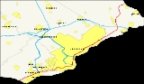
Interstate 95 in Pennsylvania
Encyclopedia
Interstate 95 is an Interstate highway running from Miami, Florida
north to Houlton, Maine
. In the U.S. state
of Pennsylvania
, the route is known by many as the Delaware Expressway, but is officially named The Vietnam Veterans Memorial Highway. and locally known as "95". It runs 51 miles (82.1 km) from the Delaware
state line near Marcus Hook
to the New Jersey
state line crossing the Delaware River
near Yardley
on the Scudder Falls Bridge
. It parallels its namesake Delaware River
for its entire route through the city of Philadelphia and its suburbs. It is a major route through the city and the metropolitan Delaware Valley
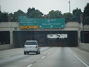
, providing access to locally important landmarks such as Philadelphia International Airport
, the Philadelphia Sports Complex, PPL Park, Penn's Landing
, and Franklin Mills
. Of the 15 states that Interstate 95 runs through, Pennsylvania
is the only one that does not border the Atlantic Ocean
.
Plans for a limited-access route along the Delaware River in the Philadelphia area originated in the 1930s when both a parkway
and elevated highway were proposed; neither of these were built. The Delaware Expressway was approved in 1945 as a toll road
that was to be part of the Pennsylvania Turnpike
system until the project was turned to the Pennsylvania Department of Highways in 1956, with the expressway to be included in the Interstate Highway System
as part of I-95. Construction on I-95 began in 1959 and was mostly complete by 1979, with the final portion near the Philadelphia International Airport finished in 1985. The route was originally projected to run through the center of Trenton, New Jersey
, but was rerouted to the Scudder Falls Bridge due to limited capacity in Trenton. In March 2008, large cracks were discovered on a bridge support column in Philadelphia, requiring a two-mile section of the route to be closed for two days. Bridges are planned to be rebuilt along the section of I-95 between Center City and Woodhaven Road (Pennsylvania Route 63
) and an interchange is planned to be built with the Pennsylvania Turnpike (Interstate 276) where I-95 will be rerouted to follow the Pennsylvania Turnpike to the New Jersey Turnpike
and Interstate 195
will be extended along the current portion of I-95 north of the proposed interchange.
, from Delaware
near Marcus Hook
, just north of its junction with the northern end of Interstate 495
. The route interchanges with Chichester Avenue and Pennsylvania Route 452
before meeting U.S. Route 322
. I-95 forms a concurrency
with US 322 that lasts until that route heads east for the Commodore Barry Bridge
. I-95 continues through Chester
, interchanging with Kerlin Street and Pennsylvania Route 320
/Pennsylvania Route 352
before coming to the southern end of Interstate 476
at the edge of the city. It continues in an eastward direction paralleling Pennsylvania Route 291
through the suburbs of Essington and Tinicum
, interchanging with Stewart Avenue and Pennsylvania Route 420
. The road enters Philadelphia, where it comes to an interchange with PA 291 that has access to the Philadelphia International Airport
. East of the airport, I-95 crosses the Schuylkill River
on the double-decker Girard Point Bridge
.
_exit_9b.jpg) Past the Schuylkill River, I-95 continues east into South Philadelphia
Past the Schuylkill River, I-95 continues east into South Philadelphia
as an elevated freeway, passing south of the Philadelphia Sports Complex and north of the Philadelphia Navy Yard, interchanging with Pennsylvania Route 611
(Broad Street
). The road curves north, following the bend in the Delaware River
, and runs along the waterfront, interchanging with Interstate 76
west of the Walt Whitman Bridge
. The elevated roadway gradually lowers to a depressed level approaching Center City, where it passes through several short tunnels at Penn's Landing
, passes under the Ben Franklin Bridge, and interchanges with the Vine Street Expressway (Interstate 676
and U.S. Route 30
). North of Center City, the SEPTA Market-Frankford Line
rises up from the Market Street
subway into I-95's median as the highway returns to an elevated alignment, entering one station (Spring Garden
) before diverging once more. I-95 continues through Northeast Philadelphia
, interchanging with the Betsy Ross Bridge
, Pennsylvania Route 73
at the Tacony-Palmyra Bridge
, and the Woodhaven Road expressway (Pennsylvania Route 63
) before crossing the county line into Bucks County.
North of the city, I-95 interchanges with Pennsylvania Route 132
in Bensalem Township
before heading into Bristol Township
, where it comes to an interchange with a short expressway stub to Pennsylvania Route 413
, a remnant of the unbuilt Interstate 895
. It continues north past the future site of the Pennsylvania Turnpike/Interstate 95 Interchange Project
, where it currently passes over the Pennsylvania Turnpike
(Interstate 276); the two highways were not built to connect with one another. North of I-276, I-95 interchanges with U.S. Route 1 Business/Pennsylvania Route 413
and U.S. Route 1
. The route heads into Lower Makefield Township
, where it has interchanges with Pennsylvania Route 332
and Taylorsville Road (which provides access to Pennsylvania Route 32
) before crossing the Delaware River
into New Jersey
on the Scudder Falls Bridge
. This current bridge structure, while structurally sufficient, is functionally obsolete due to high traffic levels and is slated to be improved. An estimated 169,000 motorists utilize the road daily.
originated in 1932, as part of a proposed cars-only parkway
system for the Philadelphia area similar to the contemporary system being built in New York City
. However, planning for the proposed parkway system stalled and the plan was eventually abandoned. In 1937, plans for the highway were revived as the "Delaware Skyway", a planned elevated highway along the waterfront similar in design to the West Side Highway
in New York, though these plans were also scrapped due to concerns that the supports would hinder access to port
operations on the waterfront.
 In 1945, the city approved the current routing as the Delaware Expressway, envisioned to link all the industrial areas along the river with the Industrial Highway and the Trenton-Morrisville Toll Bridge
to New Jersey
. The planned highway was incorporated into the Pennsylvania Turnpike
system, and was planned to be built as a toll road
. However, with the advent of the Interstate Highway System
in 1956, the project was turned over to the Pennsylvania Department of Highways and incorporated into Interstate 95. Construction on the road commenced in 1959.
Original plans called for the expressway to follow the U.S. Route 13
corridor to the Trenton-Morrisville Toll Bridge, where I-95 would continue north along today's Trenton Freeway. However, due to limited capacity of the highway through Trenton
, planners instead opted to build a new alignment bypassing Trenton to the west, incorporating the existing Scudder Falls Bridge
.
Controversy erupted in the early 1960s over the planned eight-lane elevated segment of the highway along the Center City waterfront; residents of the upscale Society Hill
neighborhood objected to the highway on the grounds that it would cut off the neighborhood from the river. State highway officials reached a compromise by opting for an alternative depressed design with an overhead concrete deck connecting Center City to a planned redeveloped waterfront today known as Penn's Landing
. By 1979, the entire length of the expressway was open to traffic with the exception of a four-mile (6 km) segment near Philadelphia International Airport
.
Completion of the final section of the highway faced considerable difficulty, as the road was to be built on a layer of clay
separating the city's water supply from the output of its sewage treatment plant. Matters were complicated by a two-year suspension of federal highway funding while the state failed to implement a federally mandated emissions testing program. This final segment was opened to traffic in 1985, marking the completion of the 35-year project.
On March 18, 2008, two miles (3 km) of I-95 within Philadelphia were forced to be closed when PennDOT discovered large cracks in a support column underneath the highway. In order to prevent possible collapse, I-95 was closed between Exit 23 (Girard Avenue) and Exit 25 (Allegheny Avenue). PennDOT worked quickly to stiffen the support beams to allow the road to be raised off the column, using 16 jacks, early on March 20. PennDOT reopened the road shortly thereafter, and plans to replace the cracked column.
A project is currently underway to build an interchange between I-95 and the Pennsylvania Turnpike
(Interstate 276) where the two highways cross but do not currently interchange with each other. Following the completion of the project, the Pennsylvania Turnpike east of the interchange will be redesignated I-95 to connect with the New Jersey Turnpike
portion of the route, while the current I-95 north of the interchange will become part of an extended Interstate 195
. The interchange between the Pennsylvania Turnpike and I-95 is to be completed in 2017. In addition, PennDOT is currently rebuilding all of the I-95 bridges in Philadelphia between Cottman Avenue (PA Rt. 73
) and the Benjamin Franklin Bridge
, in which I-95 will have a total of eight lanes between Central Philadelphia and the Woodhaven Road (PA Rt. 63
) exit. The project was planned well in advance of the I-35W Bridge Collapse and will replace bridge spans that were built in the 1960s.
} Cottman Avenue, Rhawn Street
|
|-
|32.06
|32
|Academy Road, Linden Avenue
|
|-
|rowspan=9|Bucks
|rowspan=2|Andalusia
|34.66
|35
|
|
|-
|
|
| Cornwells Heights Park & Ride
|Southbound exit and northbound entrance
|-
|Eddington
|36.35
|37
|
|
|-
|Bristol Township
|39.48
|40
|
|
|-
|Penndel
|43.31
|44
|
|
|-
|Middletown Township
|
|46
| – Morrisville
, Langhorne
|Signed as exits 46A (north) and 46B (south)
|-
|rowspan=2|Lower Makefield Township
|48.49
|49
|
|
|-
|50.75
|51
|New Hope
, Yardley
|Signed as exits 51A (Yardley) and 51B (New Hope) southbound
|-
|colspan=6 align="center"|Scudder Falls Bridge
over the Delaware River
|}
Miami, Florida
Miami is a city located on the Atlantic coast in southeastern Florida and the county seat of Miami-Dade County, the most populous county in Florida and the eighth-most populous county in the United States with a population of 2,500,625...
north to Houlton, Maine
Houlton, Maine
Houlton is a town in Aroostook County, Maine, on the United States – Canada border, located at . As of the 2010 census, the town population was 6,123. It is perhaps best known as being at the northern terminus of Interstate 95 and for being the birthplace of Samantha Smith...
. In the U.S. state
U.S. state
A U.S. state is any one of the 50 federated states of the United States of America that share sovereignty with the federal government. Because of this shared sovereignty, an American is a citizen both of the federal entity and of his or her state of domicile. Four states use the official title of...
of Pennsylvania
Pennsylvania
The Commonwealth of Pennsylvania is a U.S. state that is located in the Northeastern and Mid-Atlantic regions of the United States. The state borders Delaware and Maryland to the south, West Virginia to the southwest, Ohio to the west, New York and Ontario, Canada, to the north, and New Jersey to...
, the route is known by many as the Delaware Expressway, but is officially named The Vietnam Veterans Memorial Highway. and locally known as "95". It runs 51 miles (82.1 km) from the Delaware
Delaware
Delaware is a U.S. state located on the Atlantic Coast in the Mid-Atlantic region of the United States. It is bordered to the south and west by Maryland, and to the north by Pennsylvania...
state line near Marcus Hook
Marcus Hook, Pennsylvania
Marcus Hook is a borough in Delaware County, Pennsylvania, United States. The population peaked in the 1920s with 5,324 inhabitants. 2,314 inhabitants were counted at the recent 2000 census. Marcus Hook's current mayor is James Schiliro. The borough calls itself "The Cornerstone of Pennsylvania"....
to the New Jersey
New Jersey
New Jersey is a state in the Northeastern and Middle Atlantic regions of the United States. , its population was 8,791,894. It is bordered on the north and east by the state of New York, on the southeast and south by the Atlantic Ocean, on the west by Pennsylvania and on the southwest by Delaware...
state line crossing the Delaware River
Delaware River
The Delaware River is a major river on the Atlantic coast of the United States.A Dutch expedition led by Henry Hudson in 1609 first mapped the river. The river was christened the South River in the New Netherland colony that followed, in contrast to the North River, as the Hudson River was then...
near Yardley
Yardley, Pennsylvania
Yardley is a borough in Bucks County, Pennsylvania, United States. The small community of Yardley is bordered by the Delaware River and Ewing, New Jersey on the east, and by Lower Makefield Township on the north, west, and south...
on the Scudder Falls Bridge
Scudder Falls Bridge
The Scudder Falls Bridge is a girder bridge that carries Interstate 95 over the Delaware River, connecting Lower Makefield Township in Bucks County, Pennsylvania with Ewing Township in Mercer County, New Jersey. This bridge, which was constructed from 1958 to 1959, is maintained by the Delaware...
. It parallels its namesake Delaware River
Delaware River
The Delaware River is a major river on the Atlantic coast of the United States.A Dutch expedition led by Henry Hudson in 1609 first mapped the river. The river was christened the South River in the New Netherland colony that followed, in contrast to the North River, as the Hudson River was then...
for its entire route through the city of Philadelphia and its suburbs. It is a major route through the city and the metropolitan Delaware Valley
Delaware Valley
The Delaware Valley is a term used to refer to the valley where the Delaware River flows, along with the surrounding communities. This includes the metropolitan area centered on the city of Philadelphia. Such educational institutions as Delaware Valley Regional High School in Alexandria Township...
, providing access to locally important landmarks such as Philadelphia International Airport
Philadelphia International Airport
Philadelphia International Airport is a major airport in Philadelphia, Pennsylvania, United States, and is the largest airport in the Delaware Valley region and in Pennsylvania...
, the Philadelphia Sports Complex, PPL Park, Penn's Landing
Penn's Landing
Penn's Landing is the waterfront area of the Center City along the Delaware River section of Philadelphia, Pennsylvania, United States. It is so named because the founder of Pennsylvania, William Penn, docked near here in 1682, along the now paved over Dock Creek, after landing first in New...
, and Franklin Mills
Franklin Mills
Franklin Mills is an enclosed shopping mall located in northeast Philadelphia, Pennsylvania, bordering Bensalem in Bucks County and outside Center City...
. Of the 15 states that Interstate 95 runs through, Pennsylvania
Pennsylvania
The Commonwealth of Pennsylvania is a U.S. state that is located in the Northeastern and Mid-Atlantic regions of the United States. The state borders Delaware and Maryland to the south, West Virginia to the southwest, Ohio to the west, New York and Ontario, Canada, to the north, and New Jersey to...
is the only one that does not border the Atlantic Ocean
Atlantic Ocean
The Atlantic Ocean is the second-largest of the world's oceanic divisions. With a total area of about , it covers approximately 20% of the Earth's surface and about 26% of its water surface area...
.
Plans for a limited-access route along the Delaware River in the Philadelphia area originated in the 1930s when both a parkway
Parkway
The term parkway has several distinct principal meanings and numerous synonyms around the world, for either a type of landscaped area or a type of road.Type of landscaped area:...
and elevated highway were proposed; neither of these were built. The Delaware Expressway was approved in 1945 as a toll road
Toll road
A toll road is a privately or publicly built road for which a driver pays a toll for use. Structures for which tolls are charged include toll bridges and toll tunnels. Non-toll roads are financed using other sources of revenue, most typically fuel tax or general tax funds...
that was to be part of the Pennsylvania Turnpike
Pennsylvania Turnpike
The Pennsylvania Turnpike is a toll highway system operated by the Pennsylvania Turnpike Commission in the Commonwealth of Pennsylvania, United States. The three sections of the turnpike system total . The main section extends from Ohio to New Jersey and is long...
system until the project was turned to the Pennsylvania Department of Highways in 1956, with the expressway to be included in the Interstate Highway System
Interstate Highway System
The Dwight D. Eisenhower National System of Interstate and Defense Highways, , is a network of limited-access roads including freeways, highways, and expressways forming part of the National Highway System of the United States of America...
as part of I-95. Construction on I-95 began in 1959 and was mostly complete by 1979, with the final portion near the Philadelphia International Airport finished in 1985. The route was originally projected to run through the center of Trenton, New Jersey
Trenton, New Jersey
Trenton is the capital of the U.S. state of New Jersey and the county seat of Mercer County. As of the 2010 United States Census, Trenton had a population of 84,913...
, but was rerouted to the Scudder Falls Bridge due to limited capacity in Trenton. In March 2008, large cracks were discovered on a bridge support column in Philadelphia, requiring a two-mile section of the route to be closed for two days. Bridges are planned to be rebuilt along the section of I-95 between Center City and Woodhaven Road (Pennsylvania Route 63
Pennsylvania Route 63
Pennsylvania Route 63 is a long state highway located in the Philadelphia, Pennsylvania area. The western terminus of the route is at PA 29 in Green Lane, Montgomery County. The eastern terminus is at Interstate 95 in Bensalem Township, Bucks County...
) and an interchange is planned to be built with the Pennsylvania Turnpike (Interstate 276) where I-95 will be rerouted to follow the Pennsylvania Turnpike to the New Jersey Turnpike
New Jersey Turnpike
The New Jersey Turnpike is a toll road in New Jersey, maintained by the New Jersey Turnpike Authority. According to the International Bridge, Tunnel and Turnpike Association, the Turnpike is the nation's sixth-busiest toll road and is among one of the most heavily traveled highways in the United...
and Interstate 195
Interstate 195 (New Jersey)
Interstate 195 is an auxiliary route of the Interstate Highway System located in the U.S. state of New Jersey. Its western end is at I-295 and Route 29 just south of Trenton, New Jersey in Hamilton Township, Mercer County while its eastern end is at the Garden State Parkway, Route 34 and Route...
will be extended along the current portion of I-95 north of the proposed interchange.
Route description
Interstate 95 enters Delaware County, PennsylvaniaDelaware County, Pennsylvania
Delaware County is a county located in the U.S. state of Pennsylvania. As of 2010, the population was 558,979, making it Pennsylvania's fifth most populous county, behind Philadelphia, Allegheny, Montgomery, and Bucks counties....
, from Delaware
Delaware
Delaware is a U.S. state located on the Atlantic Coast in the Mid-Atlantic region of the United States. It is bordered to the south and west by Maryland, and to the north by Pennsylvania...
near Marcus Hook
Marcus Hook, Pennsylvania
Marcus Hook is a borough in Delaware County, Pennsylvania, United States. The population peaked in the 1920s with 5,324 inhabitants. 2,314 inhabitants were counted at the recent 2000 census. Marcus Hook's current mayor is James Schiliro. The borough calls itself "The Cornerstone of Pennsylvania"....
, just north of its junction with the northern end of Interstate 495
Interstate 495 (Delaware)
Interstate 495 in Delaware is a six-lane bypass of Interstate 95 around the city of Wilmington, Delaware. Built in the mid-1970s and opened as the "Wilmington Bypass", the highway became, between 1978 and 1982, the route of I-95 around Wilmington, while the original highway through the city,...
. The route interchanges with Chichester Avenue and Pennsylvania Route 452
Pennsylvania Route 452
Pennsylvania Route 452 is a state highway in Delaware County, Pennsylvania. The route runs from U.S. Route 13 in Marcus Hook north to Pennsylvania Route 352 in Lima.-Route description:...
before meeting U.S. Route 322
U.S. Route 322
U.S. Route 322 is a long, east–west United States Highway, traversing Ohio, Pennsylvania, and New Jersey. The road is a spur of U.S. Route 22 and one of the original highways from 1926...
. I-95 forms a concurrency
Concurrency (road)
A concurrency, overlap, or coincidence in a road network is an instance of one physical road bearing two or more different highway, motorway, or other route numbers...
with US 322 that lasts until that route heads east for the Commodore Barry Bridge
Commodore Barry Bridge
The Commodore Barry Bridge is a cantilever bridge that spans the Delaware River from Chester, Pennsylvania to Bridgeport, in Logan Township, New Jersey, USA...
. I-95 continues through Chester
Chester, Pennsylvania
Chester is a city in Delaware County, Pennsylvania, United States, with a population of 33,972 at the 2010 census. Chester is situated on the Delaware River, between the cities of Philadelphia and Wilmington, Delaware.- History :...
, interchanging with Kerlin Street and Pennsylvania Route 320
Pennsylvania Route 320
Pennsylvania Route 320 is a north–south state highway in southeastern Pennsylvania. The southern terminus of the long route is at PA 291 in Chester...
/Pennsylvania Route 352
Pennsylvania Route 352
Pennsylvania Route 352 is a north–south route that begins at U.S. Route 13 in Chester and ends at U.S. Route 30 in Malvern. It is known as Middletown Road between Pennsylvania Route 452 and Pennsylvania Route 926, with the route north of Route 926 called Chester Road.- Delaware County :A few...
before coming to the southern end of Interstate 476
Interstate 476
Interstate 476 is a auxiliary Interstate Highway in the U.S. state of Pennsylvania designated between Interstate 95 near Chester and Interstate 81 near Scranton, serving as the primary north–south Interstate corridor through eastern Pennsylvania....
at the edge of the city. It continues in an eastward direction paralleling Pennsylvania Route 291
Pennsylvania Route 291
Pennsylvania Route 291 is an east–west route that connects U.S. Route 13 in the Trainer/Marcus Hook area to Interstate 76 in Southwest Philadelphia near the Walt Whitman Bridge and the South Philadelphia Sports Complex. Except for a short section between U.S. Route 13 and the...
through the suburbs of Essington and Tinicum
Tinicum Township, Delaware County, Pennsylvania
Tinicum Township, more popularly known as "Tinicum Island" or "The Island", a census-designated place and township in Delaware County, Pennsylvania, United States. The population was 4,353 at the 2000 census. Included within the township's boundaries are the communities of Essington and Lester...
, interchanging with Stewart Avenue and Pennsylvania Route 420
Pennsylvania Route 420
Pennsylvania Route 420 is a short, north–south state highway in Delaware County, Pennsylvania. The route runs from Pennsylvania Route 291 in Tinicum Township, a short distance west of the Philadelphia International Airport, to Pennsylvania Route 320 in Springfield Township.-Route...
. The road enters Philadelphia, where it comes to an interchange with PA 291 that has access to the Philadelphia International Airport
Philadelphia International Airport
Philadelphia International Airport is a major airport in Philadelphia, Pennsylvania, United States, and is the largest airport in the Delaware Valley region and in Pennsylvania...
. East of the airport, I-95 crosses the Schuylkill River
Schuylkill River
The Schuylkill River is a river in Pennsylvania. It is a designated Pennsylvania Scenic River.The river is about long. Its watershed of about lies entirely within the state of Pennsylvania. The source of its eastern branch is in the Appalachian Mountains at Tuscarora Springs, near Tamaqua in...
on the double-decker Girard Point Bridge
Girard Point Bridge
The Girard Point Bridge is a double-decked cantilever bridge carrying Interstate 95 across the Schuylkill River in Philadelphia, Pennsylvania. The bridge was opened in 1973.-Construction and Renovation in 2010 and 2011:...
.
South Philadelphia
South Philadelphia, nicknamed South Philly, is the section of Philadelphia bounded by South Street to the north, the Delaware River to the east and south, and the Schuylkill River to the west.-History:...
as an elevated freeway, passing south of the Philadelphia Sports Complex and north of the Philadelphia Navy Yard, interchanging with Pennsylvania Route 611
Pennsylvania Route 611
Pennsylvania Route 611 is a major state highway in Pennsylvania, United States, running from Interstate 95 south of downtown Philadelphia north to Interstate 380 in Coolbaugh Township, Pennsylvania in The Poconos....
(Broad Street
Broad Street (Philadelphia)
Broad Street is a major arterial street in Philadelphia, Pennsylvania, and is nearly 13 miles long.It is Pennsylvania Route 611 along its entire length with the exception of its northernmost part between Old York Road and Pennsylvania Route 309 and the southernmost part south of Interstate 95...
). The road curves north, following the bend in the Delaware River
Delaware River
The Delaware River is a major river on the Atlantic coast of the United States.A Dutch expedition led by Henry Hudson in 1609 first mapped the river. The river was christened the South River in the New Netherland colony that followed, in contrast to the North River, as the Hudson River was then...
, and runs along the waterfront, interchanging with Interstate 76
Interstate 76 (east)
Interstate 76 is an Interstate Highway in the United States, running 435 miles from an interchange with Interstate 71 west of Akron, Ohio, east to Interstate 295 near Camden, New Jersey....
west of the Walt Whitman Bridge
Walt Whitman Bridge
The Walt Whitman Bridge is a green-colored single-level suspension bridge spanning the Delaware River from Philadelphia to Gloucester City, New Jersey. Named after the poet Walt Whitman, who resided in nearby Camden toward the end of his life, the Walt Whitman Bridge is one of the larger bridges...
. The elevated roadway gradually lowers to a depressed level approaching Center City, where it passes through several short tunnels at Penn's Landing
Penn's Landing
Penn's Landing is the waterfront area of the Center City along the Delaware River section of Philadelphia, Pennsylvania, United States. It is so named because the founder of Pennsylvania, William Penn, docked near here in 1682, along the now paved over Dock Creek, after landing first in New...
, passes under the Ben Franklin Bridge, and interchanges with the Vine Street Expressway (Interstate 676
Interstate 676
Interstate 676 is an Interstate Highway that serves as a major thoroughfare through Philadelphia, Pennsylvania, where it is known as the Vine Street Expressway, and Camden, New Jersey, where it is known as the northern segment of the North–South Freeway, as well as the Martin Luther King Jr....
and U.S. Route 30
U.S. Route 30 in Pennsylvania
In the U.S. state of Pennsylvania, U.S. Route 30 runs east–west across the southern part of the state, passing through Pittsburgh and Philadelphia on its way from the West Virginia state line east to the Benjamin Franklin Bridge over the Delaware River into New Jersey...
). North of Center City, the SEPTA Market-Frankford Line
Market-Frankford Line
The Market–Frankford Line is a rapid transit line in Philadelphia, Pennsylvania, United States, operated by the Southeastern Pennsylvania Transportation Authority .-Route:The Market–Frankford Line begins at 69th Street Transportation Center, in Upper Darby...
rises up from the Market Street
Market Street (Philadelphia)
Market Street, originally known as High Street, is a major east–west street in Philadelphia, Pennsylvania. For the majority of its length, it serves as Pennsylvania Route 3....
subway into I-95's median as the highway returns to an elevated alignment, entering one station (Spring Garden
Spring Garden (MFL station)
Spring Garden Station is an elevated stop on the Market-Frankford Line, above the corner of 2nd Street and Spring Garden Street in Philadelphia, Pennsylvania, in the Northern Liberties neighborhood...
) before diverging once more. I-95 continues through Northeast Philadelphia
Northeast Philadelphia
Northeast Philadelphia, nicknamed Northeast Philly, the Northeast and the Great Northeast, is a section of the city of Philadelphia, Pennsylvania. According to the 2000 Census, the Northeast has a sizable percentage of the city's 1.547 million people — a population of between 300,000 and 450,000,...
, interchanging with the Betsy Ross Bridge
Betsy Ross Bridge
The Betsy Ross Bridge is a continuous truss bridge spanning the Delaware River from Philadelphia to Pennsauken, New Jersey. It was originally planned as the Delair Bridge, after a paralleling vertical lift bridge owned by Pennsylvania Railroad , but was instead named for Betsy Ross, reputed creator...
, Pennsylvania Route 73
Pennsylvania Route 73
Pennsylvania Route 73 is a 62.51 miles long east–west state highway in southeastern Pennsylvania. It runs from Pennsylvania Route 61 in Leesport to the New Jersey state line on the Tacony-Palmyra Bridge in Philadelphia, where it continues as New Jersey Route 73.Predating the Interstate...
at the Tacony-Palmyra Bridge
Tacony-Palmyra Bridge
The Tacony–Palmyra Bridge is a combination steel arch, double-leaf bascule bridge across the Delaware River, connecting New Jersey Route 73 in Palmyra, New Jersey and Pennsylvania Route 73 in the Tacony section of Philadelphia. The bridge has a total length of 3,659 feet and spans 2,324 feet . It...
, and the Woodhaven Road expressway (Pennsylvania Route 63
Pennsylvania Route 63
Pennsylvania Route 63 is a long state highway located in the Philadelphia, Pennsylvania area. The western terminus of the route is at PA 29 in Green Lane, Montgomery County. The eastern terminus is at Interstate 95 in Bensalem Township, Bucks County...
) before crossing the county line into Bucks County.
North of the city, I-95 interchanges with Pennsylvania Route 132
Pennsylvania Route 132
Pennsylvania Route 132 is a state highway in southeast Pennsylvania. It runs northwest to southeast through Bucks County in suburban Philadelphia from PA 611 in Warrington Township to Interstate 95 in Bensalem Township. It is a commercial route lined with shopping centers throughout much of its...
in Bensalem Township
Bensalem Township, Pennsylvania
Bensalem Township is a township in Bucks County, Pennsylvania, United States which borders the northeast section of Philadelphia. The township is composed of many communities, including Bensalem, Trevose, Oakford, Cornwells Heights, Eddington, and Andalusia...
before heading into Bristol Township
Bristol Township, Pennsylvania
Bristol Township is a township in Bucks County, Pennsylvania, United States. The population was 54,582 at the 2010 census, making it the 13th largest municipality in the state. Bristol Township, along with Bristol Borough, is a cultural hub for Lower Bucks County, hosting celebrations of African...
, where it comes to an interchange with a short expressway stub to Pennsylvania Route 413
Pennsylvania Route 413
Pennsylvania Route 413 is a long, north–south state highway running from the PA/NJ state line on the Burlington-Bristol Bridge to PA 611 in Bedminster Township in Bucks County...
, a remnant of the unbuilt Interstate 895
Interstate 895 (New Jersey-Pennsylvania)
Interstate 895 was a planned long Interstate Highway in New Jersey and Pennsylvania that would have provided a freeway between I-295 near Burlington in Burlington County, New Jersey and Interstate 95 near Bristol in Bucks County, Pennsylvania....
. It continues north past the future site of the Pennsylvania Turnpike/Interstate 95 Interchange Project
Pennsylvania Turnpike/Interstate 95 Interchange Project
The Pennsylvania Turnpike/Interstate 95 Interchange Project is a project to build an interchange where Interstate 95 crosses the Pennsylvania Turnpike in Bristol Township, Pennsylvania. This will fill the gap that exists on I-95 through New Jersey due to the cancellation of the Somerset Freeway....
, where it currently passes over the Pennsylvania Turnpike
Pennsylvania Turnpike
The Pennsylvania Turnpike is a toll highway system operated by the Pennsylvania Turnpike Commission in the Commonwealth of Pennsylvania, United States. The three sections of the turnpike system total . The main section extends from Ohio to New Jersey and is long...
(Interstate 276); the two highways were not built to connect with one another. North of I-276, I-95 interchanges with U.S. Route 1 Business/Pennsylvania Route 413
Pennsylvania Route 413
Pennsylvania Route 413 is a long, north–south state highway running from the PA/NJ state line on the Burlington-Bristol Bridge to PA 611 in Bedminster Township in Bucks County...
and U.S. Route 1
U.S. Route 1 in Pennsylvania
U.S. Route 1 is a major north–south U.S. Highway, extending from the Florida Keys in the south to the Canadian border in the north. In the U.S. state of Pennsylvania, US 1 runs for from the Maryland state line near Oxford to the New Jersey state line near Trenton.-Maryland to Interstate...
. The route heads into Lower Makefield Township
Lower Makefield Township, Pennsylvania
Lower Makefield Township is a township in Bucks County, Pennsylvania, USA and usually referred to as "Yardley" due to the prominence of Yardley Borough in that area...
, where it has interchanges with Pennsylvania Route 332
Pennsylvania Route 332
Pennsylvania Route 332 is a state highway in the U.S. state of Pennsylvania. The route runs from Pennsylvania Route 263 in Hatboro, Montgomery County east to Pennsylvania Route 32 in Yardley, Bucks County.-Route description:...
and Taylorsville Road (which provides access to Pennsylvania Route 32
Pennsylvania Route 32
Pennsylvania Route 32 is a scenic two-lane highway that runs along the side of the Delaware River in Bucks County, Pennsylvania. It begins at U.S. 1 in Falls Township and ends at Pennsylvania Route 611 near the village of Kintnersville...
) before crossing the Delaware River
Delaware River
The Delaware River is a major river on the Atlantic coast of the United States.A Dutch expedition led by Henry Hudson in 1609 first mapped the river. The river was christened the South River in the New Netherland colony that followed, in contrast to the North River, as the Hudson River was then...
into New Jersey
New Jersey
New Jersey is a state in the Northeastern and Middle Atlantic regions of the United States. , its population was 8,791,894. It is bordered on the north and east by the state of New York, on the southeast and south by the Atlantic Ocean, on the west by Pennsylvania and on the southwest by Delaware...
on the Scudder Falls Bridge
Scudder Falls Bridge
The Scudder Falls Bridge is a girder bridge that carries Interstate 95 over the Delaware River, connecting Lower Makefield Township in Bucks County, Pennsylvania with Ewing Township in Mercer County, New Jersey. This bridge, which was constructed from 1958 to 1959, is maintained by the Delaware...
. This current bridge structure, while structurally sufficient, is functionally obsolete due to high traffic levels and is slated to be improved. An estimated 169,000 motorists utilize the road daily.
History
Plans for a limited-access highway along the Delaware RiverDelaware River
The Delaware River is a major river on the Atlantic coast of the United States.A Dutch expedition led by Henry Hudson in 1609 first mapped the river. The river was christened the South River in the New Netherland colony that followed, in contrast to the North River, as the Hudson River was then...
originated in 1932, as part of a proposed cars-only parkway
Parkway
The term parkway has several distinct principal meanings and numerous synonyms around the world, for either a type of landscaped area or a type of road.Type of landscaped area:...
system for the Philadelphia area similar to the contemporary system being built in New York City
New York City
New York is the most populous city in the United States and the center of the New York Metropolitan Area, one of the most populous metropolitan areas in the world. New York exerts a significant impact upon global commerce, finance, media, art, fashion, research, technology, education, and...
. However, planning for the proposed parkway system stalled and the plan was eventually abandoned. In 1937, plans for the highway were revived as the "Delaware Skyway", a planned elevated highway along the waterfront similar in design to the West Side Highway
West Side Highway
The West Side Highway is a mostly surface section of New York State Route 9A that runs from West 72nd Street along the Hudson River to the southern tip of Manhattan. It replaced the West Side Elevated Highway, built between 1929 and 1951, which was shut down in 1973 due to neglect and lack of...
in New York, though these plans were also scrapped due to concerns that the supports would hinder access to port
Port
A port is a location on a coast or shore containing one or more harbors where ships can dock and transfer people or cargo to or from land....
operations on the waterfront.
Trenton-Morrisville Toll Bridge
The Trenton–Morrisville Toll Bridge is one of three road bridges connecting Trenton, New Jersey with Morrisville, Pennsylvania. Opened in 1952, it carries U.S. Route 1 and is owned and operated by the Delaware River Joint Toll Bridge Commission. This bridge's toll plaza was originally configured to...
to New Jersey
New Jersey
New Jersey is a state in the Northeastern and Middle Atlantic regions of the United States. , its population was 8,791,894. It is bordered on the north and east by the state of New York, on the southeast and south by the Atlantic Ocean, on the west by Pennsylvania and on the southwest by Delaware...
. The planned highway was incorporated into the Pennsylvania Turnpike
Pennsylvania Turnpike
The Pennsylvania Turnpike is a toll highway system operated by the Pennsylvania Turnpike Commission in the Commonwealth of Pennsylvania, United States. The three sections of the turnpike system total . The main section extends from Ohio to New Jersey and is long...
system, and was planned to be built as a toll road
Toll road
A toll road is a privately or publicly built road for which a driver pays a toll for use. Structures for which tolls are charged include toll bridges and toll tunnels. Non-toll roads are financed using other sources of revenue, most typically fuel tax or general tax funds...
. However, with the advent of the Interstate Highway System
Interstate Highway System
The Dwight D. Eisenhower National System of Interstate and Defense Highways, , is a network of limited-access roads including freeways, highways, and expressways forming part of the National Highway System of the United States of America...
in 1956, the project was turned over to the Pennsylvania Department of Highways and incorporated into Interstate 95. Construction on the road commenced in 1959.
Original plans called for the expressway to follow the U.S. Route 13
U.S. Route 13
U.S. Route 13 is a north–south U.S. highway established in 1926 that runs for from Interstate 95 just north of Fayetteville, North Carolina to the northeastern suburbs of Philadelphia, Pennsylvania, in Morrisville. In all, it traverses five states in the Atlantic coastal plain region,...
corridor to the Trenton-Morrisville Toll Bridge, where I-95 would continue north along today's Trenton Freeway. However, due to limited capacity of the highway through Trenton
Trenton, New Jersey
Trenton is the capital of the U.S. state of New Jersey and the county seat of Mercer County. As of the 2010 United States Census, Trenton had a population of 84,913...
, planners instead opted to build a new alignment bypassing Trenton to the west, incorporating the existing Scudder Falls Bridge
Scudder Falls Bridge
The Scudder Falls Bridge is a girder bridge that carries Interstate 95 over the Delaware River, connecting Lower Makefield Township in Bucks County, Pennsylvania with Ewing Township in Mercer County, New Jersey. This bridge, which was constructed from 1958 to 1959, is maintained by the Delaware...
.
Controversy erupted in the early 1960s over the planned eight-lane elevated segment of the highway along the Center City waterfront; residents of the upscale Society Hill
Society Hill, Philadelphia, Pennsylvania
Society Hill is a neighborhood in the Center City section of Philadelphia, Pennsylvania, United States. The neighborhood, loosely defined as bounded by Walnut, Lombard, Front and 7th Streets, contains the largest concentration of original 18th- and early 19th-century architecture of any place in...
neighborhood objected to the highway on the grounds that it would cut off the neighborhood from the river. State highway officials reached a compromise by opting for an alternative depressed design with an overhead concrete deck connecting Center City to a planned redeveloped waterfront today known as Penn's Landing
Penn's Landing
Penn's Landing is the waterfront area of the Center City along the Delaware River section of Philadelphia, Pennsylvania, United States. It is so named because the founder of Pennsylvania, William Penn, docked near here in 1682, along the now paved over Dock Creek, after landing first in New...
. By 1979, the entire length of the expressway was open to traffic with the exception of a four-mile (6 km) segment near Philadelphia International Airport
Philadelphia International Airport
Philadelphia International Airport is a major airport in Philadelphia, Pennsylvania, United States, and is the largest airport in the Delaware Valley region and in Pennsylvania...
.
Completion of the final section of the highway faced considerable difficulty, as the road was to be built on a layer of clay
Clay
Clay is a general term including many combinations of one or more clay minerals with traces of metal oxides and organic matter. Geologic clay deposits are mostly composed of phyllosilicate minerals containing variable amounts of water trapped in the mineral structure.- Formation :Clay minerals...
separating the city's water supply from the output of its sewage treatment plant. Matters were complicated by a two-year suspension of federal highway funding while the state failed to implement a federally mandated emissions testing program. This final segment was opened to traffic in 1985, marking the completion of the 35-year project.
On March 18, 2008, two miles (3 km) of I-95 within Philadelphia were forced to be closed when PennDOT discovered large cracks in a support column underneath the highway. In order to prevent possible collapse, I-95 was closed between Exit 23 (Girard Avenue) and Exit 25 (Allegheny Avenue). PennDOT worked quickly to stiffen the support beams to allow the road to be raised off the column, using 16 jacks, early on March 20. PennDOT reopened the road shortly thereafter, and plans to replace the cracked column.
Future
A project is currently underway to build an interchange between I-95 and the Pennsylvania Turnpike
Pennsylvania Turnpike
The Pennsylvania Turnpike is a toll highway system operated by the Pennsylvania Turnpike Commission in the Commonwealth of Pennsylvania, United States. The three sections of the turnpike system total . The main section extends from Ohio to New Jersey and is long...
(Interstate 276) where the two highways cross but do not currently interchange with each other. Following the completion of the project, the Pennsylvania Turnpike east of the interchange will be redesignated I-95 to connect with the New Jersey Turnpike
New Jersey Turnpike
The New Jersey Turnpike is a toll road in New Jersey, maintained by the New Jersey Turnpike Authority. According to the International Bridge, Tunnel and Turnpike Association, the Turnpike is the nation's sixth-busiest toll road and is among one of the most heavily traveled highways in the United...
portion of the route, while the current I-95 north of the interchange will become part of an extended Interstate 195
Interstate 195 (New Jersey)
Interstate 195 is an auxiliary route of the Interstate Highway System located in the U.S. state of New Jersey. Its western end is at I-295 and Route 29 just south of Trenton, New Jersey in Hamilton Township, Mercer County while its eastern end is at the Garden State Parkway, Route 34 and Route...
. The interchange between the Pennsylvania Turnpike and I-95 is to be completed in 2017. In addition, PennDOT is currently rebuilding all of the I-95 bridges in Philadelphia between Cottman Avenue (PA Rt. 73
Pennsylvania Route 73
Pennsylvania Route 73 is a 62.51 miles long east–west state highway in southeastern Pennsylvania. It runs from Pennsylvania Route 61 in Leesport to the New Jersey state line on the Tacony-Palmyra Bridge in Philadelphia, where it continues as New Jersey Route 73.Predating the Interstate...
) and the Benjamin Franklin Bridge
Benjamin Franklin Bridge
The Benjamin Franklin Bridge , originally named the Delaware River Bridge, is a suspension bridge across the Delaware River connecting Philadelphia, Pennsylvania and Camden, New Jersey...
, in which I-95 will have a total of eight lanes between Central Philadelphia and the Woodhaven Road (PA Rt. 63
Pennsylvania Route 63
Pennsylvania Route 63 is a long state highway located in the Philadelphia, Pennsylvania area. The western terminus of the route is at PA 29 in Green Lane, Montgomery County. The eastern terminus is at Interstate 95 in Bensalem Township, Bucks County...
) exit. The project was planned well in advance of the I-35W Bridge Collapse and will replace bridge spans that were built in the 1960s.
Exit list
| County | Location | Mile | Exit Exit number An exit number is a number assigned to a road junction, usually an exit from a freeway. It is usually marked on the same sign as the destinations of the exit, as well as a sign in the gore.... |
Destinations | Notes |
|---|---|---|---|---|---|
| Delaware Delaware County, Pennsylvania Delaware County is a county located in the U.S. state of Pennsylvania. As of 2010, the population was 558,979, making it Pennsylvania's fifth most populous county, behind Philadelphia, Allegheny, Montgomery, and Bucks counties.... |
Boothwyn Boothwyn, Pennsylvania Boothwyn is a census-designated place in Delaware County, Pennsylvania, United States. The population was 5,206 at the 2000 census.-Geography:Boothwyn is located at .... |
1.16 | 1 | Chichester Avenue | |
| Linwood Linwood, Pennsylvania Linwood is a census-designated place in Delaware County, Pennsylvania, United States. The population was 3,374 at the 2000 census.-Geography:Linwood is located at .... |
1.72 | 2 | |||
| Chester Chester, Pennsylvania Chester is a city in Delaware County, Pennsylvania, United States, with a population of 33,972 at the 2010 census. Chester is situated on the Delaware River, between the cities of Philadelphia and Wilmington, Delaware.- History :... |
2.85 | 3A | South end of US 322 overlap; southbound exit and northbound entrance | ||
| 3 | Highland Avenue | ||||
| 3.62 | 4 | - New Jersey New Jersey New Jersey is a state in the Northeastern and Middle Atlantic regions of the United States. , its population was 8,791,894. It is bordered on the north and east by the state of New York, on the southeast and south by the Atlantic Ocean, on the west by Pennsylvania and on the southwest by Delaware... |
North end of US 322 overlap | ||
| 4.50 | 5 | Kerlin Street | Northbound exit and southbound entrance | ||
| 5.62 | 6 | ||||
| 6.64 | 7 | Southern terminus of Interstate 476 | |||
| Ridley Park Ridley Park, Pennsylvania Ridley Park is a borough in Delaware County, Pennsylvania, United States. The population was 7,196 at the 2000 census. Ridley Park is the home of Boeing Helicopters.-Native American:... |
7.78 | 8 | Ridley Park Ridley Park, Pennsylvania Ridley Park is a borough in Delaware County, Pennsylvania, United States. The population was 7,196 at the 2000 census. Ridley Park is the home of Boeing Helicopters.-Native American:... |
To Harrah's Chester Harrah's Chester Harrah's Chester: Casino and Racetrack is a racino on the Chester, Pennsylvania waterfront.The track's first harness racing season opened on September 10, 2006. Wagering is available on live horse races from April 23 to November 23 on Sunday, Wednesday, Thursday, and some Fridays; or via simulcast... |
|
| Tinicum Township Tinicum Township, Pennsylvania Tinicum Township, Pennsylvania could refer to:*Tinicum Township, Bucks County, Pennsylvania*Tinicum Township, Delaware County, Pennsylvania... |
9 | Signed as exits 9A (south) and 9B (north) | |||
| 10.25 | 12B | Signed as exit 10 northbound | |||
| Philadelphia Philadelphia County, Pennsylvania -History:Tribes of Lenape were the first known occupants in the area which became Philadelphia County. The first European settlers were Swedes and Finns who arrived in 1638. The Netherlands seized the area in 1655, but permanently lost control to England in 1674... |
Philadelphia | ||||
| 12.17 | 12A | Philadelphia International Airport Philadelphia International Airport Philadelphia International Airport is a major airport in Philadelphia, Pennsylvania, United States, and is the largest airport in the Delaware Valley region and in Pennsylvania... |
Signed as exit 12 northbound | ||
| 13.14 | 13 | Northbound exit and southbound entrance | |||
| 13.71 | 14 | Bartram Avenue, Essington Avenue | Southbound exit and northbound entrance | ||
| 14.56 | 15 | Enterprise Avenue, Island Avenue | Southbound exit and northbound entrance | ||
| 16.74 | 17 | ||||
| 18.51 | 19 | ||||
| 20.43 | 20 | Columbus Boulevard, Washington Avenue | |||
| 21.89 | 22 | , Ben Franklin Bridge | |||
| 23.38 | 23 | Girard Avenue Girard Avenue Girard Avenue is a major east-west thoroughfare in Philadelphia that forms sections of U.S. Route 13 and U.S. Route 30 and is named for Franco-American financier Stephen Girard. It stretches through several major neighborhoods of Philadelphia, including West Philadelphia, Fishtown, Kensington, and... , Lehigh Avenue |
|||
| 24.87 | 25 | Allegheny Avenue, Castor Avenue | |||
| 26.15 | 26 | ||||
| 27.18 | 27 | Bridge Street, Harbison Avenue | |||
| 29.80 | 30 |
|
|-
|32.06
|32
|Academy Road, Linden Avenue
|
|-
|rowspan=9|Bucks
Bucks County, Pennsylvania
- Industry and commerce :The boroughs of Bristol and Morrisville were prominent industrial centers along the Northeast Corridor during World War II. Suburban development accelerated in Lower Bucks in the 1950s with the opening of Levittown, Pennsylvania, the second such "Levittown" designed by...
|rowspan=2|Andalusia
Andalusia, Pennsylvania
Andalusia is a historic neighborhood in Bensalem Township, Bucks County, Pennsylvania, bordering Philadelphia. The ZIP code is 19020. The area is the southernmost part of the township and of the county. Its boundaries are: Woodhaven Road to the northeast, the Delaware River to the east and south,...
|34.66
|35
|
|
|-
|
|
| Cornwells Heights Park & Ride
Cornwells Heights (SEPTA station)
Cornwells Heights Station is a commuter rail station in the northeast suburbs of Philadelphia on Station Avenue near Bristol Pike in Bensalem Township, Pennsylvania, 16.9 miles from upper level 30th St Station. Its name derives from the surrounding CDP of Cornwells Heights.It is served by Amtrak's...
|Southbound exit and northbound entrance
|-
|Eddington
|36.35
|37
|
|
|-
|Bristol Township
Bristol Township, Pennsylvania
Bristol Township is a township in Bucks County, Pennsylvania, United States. The population was 54,582 at the 2010 census, making it the 13th largest municipality in the state. Bristol Township, along with Bristol Borough, is a cultural hub for Lower Bucks County, hosting celebrations of African...
|39.48
|40
|
|
|-
|Penndel
Penndel, Pennsylvania
Penndel is a borough in Bucks County, Pennsylvania, United States. The population was 2,328 at the 2010 census.-Geography:Penndel is located at ....
|43.31
|44
|
|
|-
|Middletown Township
Middletown Township, Pennsylvania
Middletown Township is the name of some places in the U.S. state of Pennsylvania:*Middletown Township, Bucks County, Pennsylvania*Middletown Township, Delaware County, Pennsylvania*Middletown Township, Susquehanna County, Pennsylvania...
|
|46
| – Morrisville
Morrisville, Bucks County, Pennsylvania
Morrisville is a borough in Bucks County, Pennsylvania, United States. The population was 8,728 at the 2010 census.-Geography:Morrisville is located at . It is situated on the Delaware River directly across from Trenton, New Jersey...
, Langhorne
Langhorne, Pennsylvania
Langhorne is a borough in Bucks County, Pennsylvania, United States. The population was 1,622 at the 2010 census.The name "Langhorne" is used broadly to describe the majority of surrounding Middletown Township, which for the most part uses Langhorne's zip code of 19047...
|Signed as exits 46A (north) and 46B (south)
|-
|rowspan=2|Lower Makefield Township
Lower Makefield Township, Pennsylvania
Lower Makefield Township is a township in Bucks County, Pennsylvania, USA and usually referred to as "Yardley" due to the prominence of Yardley Borough in that area...
|48.49
|49
|
|
|-
|50.75
|51
|New Hope
New Hope, Pennsylvania
New Hope, formerly known as Coryell's Ferry, is a borough in Bucks County, Pennsylvania, USA. The population was 2,528 at the 2010 census. The borough lies on the west bank of the Delaware River at its confluence with Aquetong Creek. A two-lane bridge carries automobile and foot traffic across the...
, Yardley
Yardley, Pennsylvania
Yardley is a borough in Bucks County, Pennsylvania, United States. The small community of Yardley is bordered by the Delaware River and Ewing, New Jersey on the east, and by Lower Makefield Township on the north, west, and south...
|Signed as exits 51A (Yardley) and 51B (New Hope) southbound
|-
|colspan=6 align="center"|Scudder Falls Bridge
Scudder Falls Bridge
The Scudder Falls Bridge is a girder bridge that carries Interstate 95 over the Delaware River, connecting Lower Makefield Township in Bucks County, Pennsylvania with Ewing Township in Mercer County, New Jersey. This bridge, which was constructed from 1958 to 1959, is maintained by the Delaware...
over the Delaware River
Delaware River
The Delaware River is a major river on the Atlantic coast of the United States.A Dutch expedition led by Henry Hudson in 1609 first mapped the river. The river was christened the South River in the New Netherland colony that followed, in contrast to the North River, as the Hudson River was then...
|}