
Interstate 95 in South Carolina
Encyclopedia
Interstate 95 is a major Interstate Highway, running along the East Coast
of the United States
from Florida
to Maine
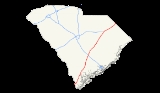
. In South Carolina
, I-95 runs approximately parallel to the Atlantic Ocean shore although about 50 miles (80.5 km) inland, from Hardeeville
in the south to Dillon
in the northeast.
provides an unexpected scenic break in the center of the highway's length. Moving further north and out of the Palmetto State, the NC state line is prominently marked by the South Of The Border amusement complex at the US 301/501 exit. Local traffic parallel to the interstate uses US 301 from South Of The Border to Santee, US 15 from Santee to Walterboro, and a combination of US 17 and US 17A from Walterboro to the Georgia
state line north of Savannah
. In addition, Interstate 95 shares a number of concurrencies
, or multiplexes, with 3 of these U.S. Routes at various stretches in South Carolina.
The old US 15-301 bridge runs along the west side of I-95 and is used for recreational purposes.
and extends one-half mile on both sides of mile marker 7. In May 1997, the General Assembly of the State of South Carolina
passed a resolution to designate this section of Interstate 95 in honor of Lance Corporal
Mark Hunter Coates, who served as a trooper
with the South Carolina Highway Patrol
from 1987 until his death in 1992. Coates, who was a native of Lexington County, South Carolina was fatally shot on mile marker 7 on November 20, 1992 during the course of a traffic stop.
 Like virtually all state spanning stretches of the United States Interstate Highways, I-95
in South Carolina was constructed in various stages, mainly from north-to-south, from 1965 to 1980, which includes the 1968-built Lake Marion Bridge. The first traffic rolled along the highway from Dillon to Turbeville in 1968, finally able to cross the Savannah River south of Hardeeville by 1981.
|-
!County
!Location
!Exit
!Destinations
!Notes
|-
!colspan=5| crosses the Savannah River
Effingham County, Georgia
-Jasper County, South Carolina Border
|-
|rowspan=8|Jasper
|rowspan=3|Hardeeville
|5
|
|
|-
|7
|
|
|-
|8
|
|
|-
|
|18
|Road 13 – Switzerland
|
|-
|rowspan=2|Ridgeland
|21
|
|
|-
|bgcolor=#ddffdd|22
|bgcolor=#ddffdd|
|bgcolor=#ddffdd|South end of US 17 overlap
|-
|
|28
|
|
|-
|
|bgcolor=#ddffdd|33
|bgcolor=#ddffdd|
|bgcolor=#ddffdd|North end of US 17 overlap
|-
|Hampton
|Yemassee
|38
|
|
|-
|rowspan=5|Colleton
|
|42
|
|
|-
|rowspan=3|Walterboro
|53
|
|
|-
|57
|
|
|-
|62
|Road 34 – Walterboro
|
|-
|
|68
|
|
|-
!colspan=5|Bridge over Edisto River
|-
|rowspan=2|Dorchester
|St. George
|77
|
|
|-
|
|82
|
|
|-
|rowspan=6|Orangeburg
|
|86
|
|Signed as exits 86A (east) and 86B (west)
|-
|
|90
|
|
|-
|
|93
|
|US 15 later joins US 301 overlap in Santee
|-
|
|94
|
|
|-
|
|bgcolor=#ddffdd|97
|bgcolor=#ddffdd|
|bgcolor=#ddffdd|South end of US 15 and 301 overlap
|-
|Santee
|98
|
|
|-
!colspan=5|Bridge over Lake Marion
|-
|rowspan=7|Clarendon
|
|bgcolor=#ddffdd|102
|bgcolor=#ddffdd|
|bgcolor=#ddffdd|North end of US 15 and 301 overlap.
|-
|rowspan=3|Summerton
|108
|Road 102 – Summerton
|
|-
|112
|Moses Dingle Road – Summerton
|
|-
|115
|
|
|-
|rowspan=2|Manning
|119
|
|
|-
|122
|
|
|-
|
|132
|
|
|-
|rowspan=3|Sumter
|
|135
|
|
|-
|
|141
|
|
|-
|
|146
|
|
|-
|rowspan=5|Florence
|rowspan=2|Timmonsville
|150
|
|
|-
|153
|Honda Way – Timmonsville
|Includes Center Street
|-
|rowspan=3|Florence
|157
|
|
|-
|160
|
|Signed as exits 160A (east) and 160B (west)
|-
|164
|
|
|-
|Darlington
!colspan=5|No interchanges in Darlington County
|-
|rowspan=3|Florence
|
|169
|TV Road – Quinby
, Florence
|
|-
|
|170
|
|
|-
!colspan=5|Bridge over Pee Dee River
|-
|Marlboro
!colspan=5|No interchanges in Marlboro County
|-
|rowspan=4|Dillon
|
|181
|
|Signed as exits 181A (east) and 181B (west)
|-
|
|bgcolor=#ffdead|
|bgcolor=#ffdead|
|bgcolor=#ffdead|Future Interstate Exit
|-
|rowspan=2|Dillon
|190
|
|
|-
|193
|
|
|-
!colspan=8|Dillon County, South Carolina-Robeson County, North Carolina
Border
continues north into North Carolina
|-
East Coast of the United States
The East Coast of the United States, also known as the Eastern Seaboard, refers to the easternmost coastal states in the United States, which touch the Atlantic Ocean and stretch up to Canada. The term includes the U.S...
of the United States
United States
The United States of America is a federal constitutional republic comprising fifty states and a federal district...
from Florida
Florida
Florida is a state in the southeastern United States, located on the nation's Atlantic and Gulf coasts. It is bordered to the west by the Gulf of Mexico, to the north by Alabama and Georgia and to the east by the Atlantic Ocean. With a population of 18,801,310 as measured by the 2010 census, it...
to Maine
Maine
Maine is a state in the New England region of the northeastern United States, bordered by the Atlantic Ocean to the east and south, New Hampshire to the west, and the Canadian provinces of Quebec to the northwest and New Brunswick to the northeast. Maine is both the northernmost and easternmost...
. In South Carolina
South Carolina
South Carolina is a state in the Deep South of the United States that borders Georgia to the south, North Carolina to the north, and the Atlantic Ocean to the east. Originally part of the Province of Carolina, the Province of South Carolina was one of the 13 colonies that declared independence...
, I-95 runs approximately parallel to the Atlantic Ocean shore although about 50 miles (80.5 km) inland, from Hardeeville
Hardeeville, South Carolina
Hardeeville is a city in Jasper County, South Carolina, United States. The population was 2,952 at the 2010 census, a 64 percent increase from its recorded population of 1,793 from the 2000 Census...
in the south to Dillon
Dillon, South Carolina
Dillon, South Carolina, the county seat of Dillon County, was established on December 22, 1888. The name of the city came from James W. Dillon, who was a key component in bringing a railroad through this area of the state, which led to development and formation of the County. Dillon’s population...
in the northeast.
Route description
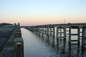
For the most part, the 198 miles (318.6 km) drive is fairly benign, passing through the pine forests, farmlands, and blackwater streams and swamps of the Coastal Plain. However, a few landmarks do exist to break up the monotony. Crossing from the south from Georgia just over the Savannah River bridge, motorists are greeted to an elaborate gateway into the state of South Carolina. The Juanita M. White Crosswalk also exists between Exits 18 and 21. A flyover on twin high-spans over Lake MarionLake Marion (South Carolina)
Lake Marion is the largest lake in South Carolina, centrally located and with territory within five counties. The lake is referred to as South Carolina's inland sea. It has a shoreline and covers nearly 110,000 acres of rolling farmlands, former marshes, and river valley landscape...
provides an unexpected scenic break in the center of the highway's length. Moving further north and out of the Palmetto State, the NC state line is prominently marked by the South Of The Border amusement complex at the US 301/501 exit. Local traffic parallel to the interstate uses US 301 from South Of The Border to Santee, US 15 from Santee to Walterboro, and a combination of US 17 and US 17A from Walterboro to the Georgia
Georgia (U.S. state)
Georgia is a state located in the southeastern United States. It was established in 1732, the last of the original Thirteen Colonies. The state is named after King George II of Great Britain. Georgia was the fourth state to ratify the United States Constitution, on January 2, 1788...
state line north of Savannah
Savannah, Georgia
Savannah is the largest city and the county seat of Chatham County, in the U.S. state of Georgia. Established in 1733, the city of Savannah was the colonial capital of the Province of Georgia and later the first state capital of Georgia. Today Savannah is an industrial center and an important...
. In addition, Interstate 95 shares a number of concurrencies
Concurrency (road)
A concurrency, overlap, or coincidence in a road network is an instance of one physical road bearing two or more different highway, motorway, or other route numbers...
, or multiplexes, with 3 of these U.S. Routes at various stretches in South Carolina.
The old US 15-301 bridge runs along the west side of I-95 and is used for recreational purposes.
Mark H. Coates Highway
The Mark H. Coates Highway is a one-mile (1.6 km) portion of Interstate 95 located in Jasper County near HardeevilleHardeeville, South Carolina
Hardeeville is a city in Jasper County, South Carolina, United States. The population was 2,952 at the 2010 census, a 64 percent increase from its recorded population of 1,793 from the 2000 Census...
and extends one-half mile on both sides of mile marker 7. In May 1997, the General Assembly of the State of South Carolina
South Carolina General Assembly
The South Carolina General Assembly, also called the South Carolina Legislature, is the state legislature of the U.S. state of South Carolina. The legislature is bicameral and consists of the lower South Carolina House of Representatives and the upper South Carolina Senate. Altogether, the General...
passed a resolution to designate this section of Interstate 95 in honor of Lance Corporal
Lance Corporal
Lance corporal is a military rank, used by many armed forces worldwide, and also by some police forces and other uniformed organizations. It is below the rank of corporal, and is typically the lowest non-commissioned officer, usually equivalent to the NATO Rank Grade OR-3.- Etymology :The presumed...
Mark Hunter Coates, who served as a trooper
Trooper (police rank)
Trooper is a rank used by several civilian police forces in the United States. In its plural form, troopers, it generally refers to members of state highway patrol or state police agencies, even though those officers may not necessarily be of the rank of trooper.For example, in the Louisiana State...
with the South Carolina Highway Patrol
South Carolina Highway Patrol
The South Carolina Highway Patrol is the highway patrol agency for South Carolina, which has jurisdiction anywhere in the state except for federal or military installations. The Highway Patrol was created in 1930 and is a paramilitary organization with a rank structure similar to the armed forces...
from 1987 until his death in 1992. Coates, who was a native of Lexington County, South Carolina was fatally shot on mile marker 7 on November 20, 1992 during the course of a traffic stop.
History
Interstate 95
Interstate 95 is the main highway on the East Coast of the United States, running parallel to the Atlantic Ocean from Maine to Florida and serving some of the most populated urban areas in the country, including Boston, Providence, New Haven, New York City, Newark, Philadelphia, Baltimore,...
in South Carolina was constructed in various stages, mainly from north-to-south, from 1965 to 1980, which includes the 1968-built Lake Marion Bridge. The first traffic rolled along the highway from Dillon to Turbeville in 1968, finally able to cross the Savannah River south of Hardeeville by 1981.
Service areas
- Northbound Welcome Center(South of Exit 5).
- Parking Areas at Exit 18 for Trucks only(Reopened 2008).
- Hendersonville Rest Areas (Between Exits 42 & 53: Both Directions).
- Northbound former truck weigh station near MM #74
- Southbound parking area for Trucks only near MM #74(Reopened 2008).
- Santee Rest Area (Between Exits 98 & 102: Northbound Only).
- Lake Marion Travel Information Center(Between Exits 102 & 98: Southbound Only).
- Shiloh Rest Areas (Between Exits 135 & 141: Both Directions).
- Pee Dee Rest Areas(Between Exits 170 & 181: Both Directions; Closed Spring 2010).
- Southbound Welcome Center(North of Exit 193).
Exit list
{|class="wikitable"|-
!County
!Location
!Exit
!Destinations
!Notes
|-
!colspan=5| crosses the Savannah River
Savannah River
The Savannah River is a major river in the southeastern United States, forming most of the border between the states of South Carolina and Georgia. Two tributaries of the Savannah, the Tugaloo River and the Chattooga River, form the northernmost part of the border...
Effingham County, Georgia
Effingham County, Georgia
Effingham County is a county located in the U.S. state of Georgia. In the United States Census of 2000, the population was 37,535. The Census Bureau's 2008 estimate estimates that this figure has grown to 52,060. The seat of Effingham County is Springfield....
-Jasper County, South Carolina Border
|-
|rowspan=8|Jasper
|rowspan=3|Hardeeville
Hardeeville, South Carolina
Hardeeville is a city in Jasper County, South Carolina, United States. The population was 2,952 at the 2010 census, a 64 percent increase from its recorded population of 1,793 from the 2000 Census...
|5
|
|
|-
|7
|
|
|-
|8
|
|
|-
|
|18
|Road 13 – Switzerland
Switzerland, South Carolina
Switzerland is an unincorporated community in Jasper County, South Carolina, United States, near the Georgia border. The community is part of the Hilton Head Island–Beaufort Micropolitan Statistical Area....
|
|-
|rowspan=2|Ridgeland
Ridgeland, South Carolina
Ridgeland is a town in Jasper County, South Carolina, United States. The population was 2,518 at the 2000 census. It has been the county seat of Jasper County since its formation in 1912, prior to which it was in Beaufort County. As defined by the U.S...
|21
|
|
|-
|bgcolor=#ddffdd|22
|bgcolor=#ddffdd|
|bgcolor=#ddffdd|South end of US 17 overlap
|-
|
|28
|
|
|-
|
|bgcolor=#ddffdd|33
|bgcolor=#ddffdd|
|bgcolor=#ddffdd|North end of US 17 overlap
|-
|Hampton
|Yemassee
Yemassee, South Carolina
Yemassee is a town in Beaufort and Hampton counties in the U.S. state of South Carolina. The population was 1,027 at the 2010 census. Yemassee is also very near the borders of Colleton and Jasper counties and is often considered to be the geographical center or heart of the Lowcountry region...
|38
|
|
|-
|rowspan=5|Colleton
|
|42
|
|
|-
|rowspan=3|Walterboro
Walterboro, South Carolina
Walterboro is a city in Colleton County, South Carolina, United States. The population was 5,153 at the 2000 census . It is the county seat of Colleton County.-History:...
|53
|
|
|-
|57
|
|
|-
|62
|Road 34 – Walterboro
Walterboro, South Carolina
Walterboro is a city in Colleton County, South Carolina, United States. The population was 5,153 at the 2000 census . It is the county seat of Colleton County.-History:...
|
|-
|
|68
|
|
|-
!colspan=5|Bridge over Edisto River
Edisto River
The Edisto River is the longest completely undammed / unleveed blackwater river in North America, flowing 206 meandering miles from its sources in Saluda and Edgefield counties, to its Atlantic Ocean mouth at Edisto Beach, SC...
|-
|rowspan=2|Dorchester
|St. George
St. George, South Carolina
Saint George is a town in Dorchester County, South Carolina, United States. The population was 2,092 at the 2000 census. It has been the county seat of Dorchester County since the latter's formation from Colleton County in 1897....
|77
|
|
|-
|
|82
|
|
|-
|rowspan=6|Orangeburg
|
|86
|
|Signed as exits 86A (east) and 86B (west)
|-
|
|90
|
|
|-
|
|93
|
|US 15 later joins US 301 overlap in Santee
|-
|
|94
|
|
|-
|
|bgcolor=#ddffdd|97
|bgcolor=#ddffdd|
|bgcolor=#ddffdd|South end of US 15 and 301 overlap
|-
|Santee
Santee, South Carolina
Santee is a town in Orangeburg County along the Santee River Valley in central South Carolina of the United States. It has become a resort town of note located centrally north-south along the Atlantic Seaboard of South Carolina...
|98
|
|
|-
!colspan=5|Bridge over Lake Marion
Lake Marion (South Carolina)
Lake Marion is the largest lake in South Carolina, centrally located and with territory within five counties. The lake is referred to as South Carolina's inland sea. It has a shoreline and covers nearly 110,000 acres of rolling farmlands, former marshes, and river valley landscape...
|-
|rowspan=7|Clarendon
|
|bgcolor=#ddffdd|102
|bgcolor=#ddffdd|
|bgcolor=#ddffdd|North end of US 15 and 301 overlap.
|-
|rowspan=3|Summerton
Summerton, South Carolina
Summerton is a town in Clarendon County, South Carolina, in the United States. The population was 1,061 at the 2000 census.-Geography:Summerton is at ....
|108
|Road 102 – Summerton
Summerton, South Carolina
Summerton is a town in Clarendon County, South Carolina, in the United States. The population was 1,061 at the 2000 census.-Geography:Summerton is at ....
|
|-
|112
|Moses Dingle Road – Summerton
Summerton, South Carolina
Summerton is a town in Clarendon County, South Carolina, in the United States. The population was 1,061 at the 2000 census.-Geography:Summerton is at ....
|
|-
|115
|
|
|-
|rowspan=2|Manning
Manning, South Carolina
Manning is a city in South Carolina and the county seat of Clarendon County in the Southeastern United States, located in the center of the county, just to the east of Interstate 95 and at the intersection of U.S. 301 and U.S. 521. The population was estimated to be 3,943 as of 2008, down 2% from...
|119
|
|
|-
|122
|
|
|-
|
|132
|
|
|-
|rowspan=3|Sumter
|
|135
|
|
|-
|
|141
|
|
|-
|
|146
|
|
|-
|rowspan=5|Florence
Florence County, South Carolina
Florence is a county located in the U.S. state of South Carolina. In 2000, its population was recorded to be 125,761; in 2005, the U.S. Census Bureau estimated that its population had reached 131,097. Its county seat is Florence. The county's population is about 60% urban and it comprises part of...
|rowspan=2|Timmonsville
Timmonsville, South Carolina
Timmonsville is a town in Florence County, South Carolina, United States. The population was 2,315 at the 2000 census. It is part of the Florence Metropolitan Statistical Area.-Geography:Timmonsville is located at ....
|150
|
|
|-
|153
|Honda Way – Timmonsville
Timmonsville, South Carolina
Timmonsville is a town in Florence County, South Carolina, United States. The population was 2,315 at the 2000 census. It is part of the Florence Metropolitan Statistical Area.-Geography:Timmonsville is located at ....
|Includes Center Street
|-
|rowspan=3|Florence
Florence, South Carolina
-Municipal government and politics:The City of Florence has a council-manager form of government. The mayor and city council are elected every four years, with no term limits...
|157
|
|
|-
|160
|
|Signed as exits 160A (east) and 160B (west)
|-
|164
|
|
|-
|Darlington
!colspan=5|No interchanges in Darlington County
|-
|rowspan=3|Florence
Florence County, South Carolina
Florence is a county located in the U.S. state of South Carolina. In 2000, its population was recorded to be 125,761; in 2005, the U.S. Census Bureau estimated that its population had reached 131,097. Its county seat is Florence. The county's population is about 60% urban and it comprises part of...
|
|169
|TV Road – Quinby
Quinby, South Carolina
Quinby is a town in Florence County, South Carolina, United States. The population was 842 at the 2000 census. It is part of the Florence Metropolitan Statistical Area.-Geography:Quinby is located at ....
, Florence
Florence, South Carolina
-Municipal government and politics:The City of Florence has a council-manager form of government. The mayor and city council are elected every four years, with no term limits...
|
|-
|
|170
|
|
|-
!colspan=5|Bridge over Pee Dee River
Pee Dee River
The Pee Dee River, also known as the Great Pee Dee River, is a river in North Carolina and South Carolina. It originates in the Appalachian Mountains in North Carolina, where its upper course above the mouth of the Uwharrie River is known as the Yadkin River. It is extensively dammed for flood...
|-
|Marlboro
!colspan=5|No interchanges in Marlboro County
|-
|rowspan=4|Dillon
|
|181
|
|Signed as exits 181A (east) and 181B (west)
|-
|
|bgcolor=#ffdead|
|bgcolor=#ffdead|
|bgcolor=#ffdead|Future Interstate Exit
|-
|rowspan=2|Dillon
Dillon, South Carolina
Dillon, South Carolina, the county seat of Dillon County, was established on December 22, 1888. The name of the city came from James W. Dillon, who was a key component in bringing a railroad through this area of the state, which led to development and formation of the County. Dillon’s population...
|190
|
|
|-
|193
|
|
|-
!colspan=8|Dillon County, South Carolina-Robeson County, North Carolina
Robeson County, North Carolina
Robeson County is a county in the U.S. state of North Carolina. As of 2010 it had a population of 134,168. Since then, it has been one of the 10% of United States counties that were majority-minority; its combined population of American Indian, African American and Latino residents comprise over...
Border
continues north into North Carolina
Interstate 95 in North Carolina
Interstate 95 is a major Interstate Highway, running along the East Coast of the United States from Florida to Maine. In North Carolina, I-95 runs diagonally across the eastern third of the state, from Rowland in the southwest to Roanoke Rapids in the northeast of the Inner Banks.-Route...
|-