
Interstate 19
Encyclopedia
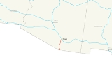
Interstate 19 is an intrastate Interstate Highway located entirely within the state of Arizona
. I-19 runs from Nogales
, roughly 1,500 feet (430 meters) from the Mexican border, to Tucson
, at Interstate 10. Having a total length of just over 63 miles, I-19 is the second shortest primary (two digit) interstate in the contiguous 48 States, where only Interstate 97
is shorter.
While the highway is short, it is a very important corridor, serving as a fast route from Tucson and Phoenix (via Interstate 10) to the Mexican Border.
The highway is a portion of the United States section of the CANAMEX Corridor
, a trade corridor that stretches north from Mexico
across the United States to the Canadian province of Alberta
.
, the southern terminus of I-19 is at West Crawford Street, adjacent to the international port of entry, and southbound travelers can continue into Nogales, Sonora, Mexico
, via state-maintained surface roads, and connect with Mexico Federal Highway 15 either to the south or west of Nogales, Sonora.
Starting from the southern terminus at kilometer post zero, I-19 initially heads briefly south then west on surface streets, navigating its way through the town of Nogales for two tenths of a mile before becoming an interstate grade highway and making the turn to head north toward Tucson. It interchanges with two other state highways near the southern end of the route, SR 189
at exit 4 and SR 289
at exit 12. The interchange with SR 189
at exit 4 both serves to funnel traffic so as to bypass around Nogales, Arizona
and Nogales, Sonora
for travelers bound to or from Hermosillo
or Mexico City
, and provides for the continuous flow of freight and truck traffic through the larger Mariposa Port of Entry to Mexico 15, which has its northern terminus at the US-Mexico Border with SR 189
and its southern terminus 2179 kilometres (1,354 mi) away in Mexico City
. After exiting Nogales to the north, I-19 passes near and around a series of sparsely populated towns and retirement communities along the banks of the Santa Cruz River, including Rio Rico
, Tubac
, Amado
, Green Valley
, and Sahuarita
. For several miles near Amado and Green Valley, the eastward view from I-19 provides scenic views of Madera Canyon
and the Santa Rita Mountains
in the Coronado National Forest
.
Just before entering Tucson
, I-19 passes through the eastern section of the San Xavier Indian Reservation
where it makes its only crossing of the Santa Cruz River. As I-19 enters the Tucson
city limits, it has an interchange at SR 86 at exit 99 before reaching its northern terminus at a junction with I-10
.
and the Gila River
, southeast of Phoenix
. Most of the time, much of the river is dry, but heavy storms can cause it to overflow its banks, flooding farmland before reaching the Gila River.
The official completion date of the I-19 segment between Tucson (km 100) and Green Valley, Arizona (actually Helmet Peak Road at km 75) was February 12, 1972. A 1978 Project Report for the Arizona Department of Transportation
lists entire I-19 project as "completed," which includes segments between Green Valley
and Nogales, Arizona
.
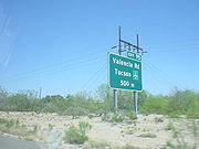 Interstate 19 is unique among US Interstates, because signed distances are given in meters (hundreds or thousands as distance-to-exit indications) or kilometers (as distance-to-destination indications), and not miles. However, the speed limit signs give speeds in miles per hour. According to the Arizona Department of Transportation (ADOT), metric signs were originally placed because of the push toward the metric system
in the United States at the time of the original construction of the highway.
Interstate 19 had originally been signed as it was constructed, in a series of small signing contracts that used customary units. In 1980, Arizona DOT awarded a single contract to install new signs which used metric units, to overlay English-unit expressions on some existing signs with metric-unit expressions, to install kilometerposts, and to provide bilingual signing in select locations. The signing scheme used in 1980 provided explicit units on advance guide signs, but not on interchange sequence signs or post-interchange confirmation (distance) signs.
The expressions on advance guide signs were of the form "2 km" for distances over 1 km and "500 m" for distances under 1 km, with no provision for fractional kilometrages. On advance guide signs, the metric unit expressions "km" and "m" were placed on the baseline where "MILES" would otherwise have gone, but were sized so that their lowercase loop height matched the uppercase letter height of "MILES" on customary-unit signs.
The exception was a handful of advance guide signs for the SR 86 Ajo Way exit, which used "KM" (in uppercase, contrary to SI nomenclature) on the same baseline and at the same letter height as "MILES." The 1980 signing plans also provided design details for speed limit and advisory speed signs using metric units, with the limit values enclosed in a red circle on the speed limit sign and a black circle on the yellow-background advisory signs. These speed signs all had explicit units, with "km/h" below the circle enclosing the limit value. However, the advisory signs were cancelled by change order and not installed.
Had the metric speed limit sign been installed, the signed speed limit on I-19 would have been 88 km/h, which is a close soft-conversion of the then-existing 55 MPH "double nickel" national maximum speed limit. Information signs, to three distinct designs, were also placed at various locations on or near I-19 to advise motorists that the highway was signed in metric. Notwithstanding the metric legends, the signing plans were dimensioned entirely in feet and inches.
In 1999, Arizona DOT awarded two contracts (administered as a single construction project) to renew the signs along the full length of I-19. The general approach toward metric signing differed from that taken in 1980. Explicit units were given not just on advance guide signs, but also on interchange sequence signs, post-interchange confirmation signs, and community interchange signs (the last-listed had not been used in 1980). On the distance signs, "km" appeared after each kilometer measurement except when one or more of the distances was a fractional kilometer.
In such cases, all the distances were given in meters with "meters" (written out in full, not "m") after each distance value. On distance signs in general, "km" or "meters" appeared on the same baseline and with the same letter height as the distance values, while advance guide signs were formatted as in 1980. Since a typical Arizona DOT freeway guide sign rehabilitation contract also replaces surface road signing near those roads' interchanges with the freeway, metric-unit signs also appeared on local roads near I-19, giving distances in kilometers to tourist attractions such as Mission San Xavier del Bac
.
As was the case in 1980, the signing plans were dimensioned in feet and inches. However, a number of signs near the Valencia Road interchange were replaced or amended when it was converted from a partial cloverleaf to a SPUI in 2000. One of these signs has a fractional kilometrage greater than 1 km, rendered as "1500 m," while others use "m" rather than "meters" as the unit expression. Metric unit expressions on the advance guide signs installed or modified as part of this contract appear on the same baseline as the metric values, rather than on a raised baseline as on other I-19 advance guide signs. Again, the plans were dimensioned in feet and inches.
Citing motorist confusion arising from the metric signs on I-19, Arizona DOT's Tucson district announced that new signs on I-19 would use United States customary units
. To avoid the cost of replacing the metric signs all at once, signs would be replaced in specific areas of the freeway during construction projects in those areas. New signs were put into place between Exit 99 (Ajo Way) and Exit 101 (Interstate 10) in 2004 after the completion of the new Interstate 10
–Interstate 19 interchange.
As of 2010, the remainder of the project has been stalled due to local opposition, particularly from businesses that would have to change their directions.
A recent reconstruction project at the Interstate's northern terminus with Interstate 10 in Tucson, Arizona
(at the interchange commonly called the Crossing) was begun in 2002 and completed in August 2004.
Arizona
Arizona ; is a state located in the southwestern region of the United States. It is also part of the western United States and the mountain west. The capital and largest city is Phoenix...
. I-19 runs from Nogales
Nogales, Arizona
Nogales is a city in Santa Cruz County, Arizona, United States. The population was 21,017 at the 2010 census. According to 2005 Census Bureau estimates, the population of the city is 20,833. The city is the county seat of Santa Cruz County....
, roughly 1,500 feet (430 meters) from the Mexican border, to Tucson
Tucson, Arizona
Tucson is a city in and the county seat of Pima County, Arizona, United States. The city is located 118 miles southeast of Phoenix and 60 miles north of the U.S.-Mexico border. The 2010 United States Census puts the city's population at 520,116 with a metropolitan area population at 1,020,200...
, at Interstate 10. Having a total length of just over 63 miles, I-19 is the second shortest primary (two digit) interstate in the contiguous 48 States, where only Interstate 97
Interstate 97
Interstate 97 is an intrastate Interstate Highway located entirely within Anne Arundel County, Maryland, United States. It runs from Annapolis at the overlapped section of US 50, US 301, and the unsigned I-595 to Baltimore at the city's beltway...
is shorter.
While the highway is short, it is a very important corridor, serving as a fast route from Tucson and Phoenix (via Interstate 10) to the Mexican Border.
The highway is a portion of the United States section of the CANAMEX Corridor
CANAMEX Corridor
The CANAMEX corridor is a corridor linking Canada to Mexico through the United States. The corridor was established under the North American Free Trade Agreement.Currently the corridor is defined by a series of highways...
, a trade corridor that stretches north from Mexico
Mexico
The United Mexican States , commonly known as Mexico , is a federal constitutional republic in North America. It is bordered on the north by the United States; on the south and west by the Pacific Ocean; on the southeast by Guatemala, Belize, and the Caribbean Sea; and on the east by the Gulf of...
across the United States to the Canadian province of Alberta
Alberta
Alberta is a province of Canada. It had an estimated population of 3.7 million in 2010 making it the most populous of Canada's three prairie provinces...
.
Route description
In Nogales, ArizonaNogales, Arizona
Nogales is a city in Santa Cruz County, Arizona, United States. The population was 21,017 at the 2010 census. According to 2005 Census Bureau estimates, the population of the city is 20,833. The city is the county seat of Santa Cruz County....
, the southern terminus of I-19 is at West Crawford Street, adjacent to the international port of entry, and southbound travelers can continue into Nogales, Sonora, Mexico
Nogales, Sonora
Heroica Nogales , more commonly known as Nogales, is a city and its surrounding municipality on the northern border of the Mexican State of Sonora. The municipality covers an area of 1,675 km², and borders to the north the city of Nogales, Arizona, United States, across the U.S.-Mexico border...
, via state-maintained surface roads, and connect with Mexico Federal Highway 15 either to the south or west of Nogales, Sonora.
Starting from the southern terminus at kilometer post zero, I-19 initially heads briefly south then west on surface streets, navigating its way through the town of Nogales for two tenths of a mile before becoming an interstate grade highway and making the turn to head north toward Tucson. It interchanges with two other state highways near the southern end of the route, SR 189
Arizona State Route 189
State Route 189 is a highway in Santa Cruz County, Arizona that runs from its junction with Interstate 19 to the US-Mexico Border...
at exit 4 and SR 289
Arizona State Route 289
State Route 289 is a highway in Santa Cruz County, Arizona that runs from its junction with Interstate 19, old U.S. Route 89 to the north of Nogales to Peña Blanca Lake. It is an east–west route.-Route description:...
at exit 12. The interchange with SR 189
Arizona State Route 189
State Route 189 is a highway in Santa Cruz County, Arizona that runs from its junction with Interstate 19 to the US-Mexico Border...
at exit 4 both serves to funnel traffic so as to bypass around Nogales, Arizona
Nogales, Arizona
Nogales is a city in Santa Cruz County, Arizona, United States. The population was 21,017 at the 2010 census. According to 2005 Census Bureau estimates, the population of the city is 20,833. The city is the county seat of Santa Cruz County....
and Nogales, Sonora
Nogales, Sonora
Heroica Nogales , more commonly known as Nogales, is a city and its surrounding municipality on the northern border of the Mexican State of Sonora. The municipality covers an area of 1,675 km², and borders to the north the city of Nogales, Arizona, United States, across the U.S.-Mexico border...
for travelers bound to or from Hermosillo
Hermosillo
Hermosillo is a city and municipality located centrally in the northwestern Mexican state of Sonora. It is the capital and main economic center for the state and region. It contains almost all of the state's manufacturing and has thirty percent of its population...
or Mexico City
Mexico City
Mexico City is the Federal District , capital of Mexico and seat of the federal powers of the Mexican Union. It is a federal entity within Mexico which is not part of any one of the 31 Mexican states but belongs to the federation as a whole...
, and provides for the continuous flow of freight and truck traffic through the larger Mariposa Port of Entry to Mexico 15, which has its northern terminus at the US-Mexico Border with SR 189
Arizona State Route 189
State Route 189 is a highway in Santa Cruz County, Arizona that runs from its junction with Interstate 19 to the US-Mexico Border...
and its southern terminus 2179 kilometres (1,354 mi) away in Mexico City
Mexico City
Mexico City is the Federal District , capital of Mexico and seat of the federal powers of the Mexican Union. It is a federal entity within Mexico which is not part of any one of the 31 Mexican states but belongs to the federation as a whole...
. After exiting Nogales to the north, I-19 passes near and around a series of sparsely populated towns and retirement communities along the banks of the Santa Cruz River, including Rio Rico
Rio Rico, Arizona
Rio Rico is a census-designated place in Santa Cruz County, Arizona, United States. The population was 18,962 at the 2010 census.-Geography:Rio Rico is located at ....
, Tubac
Tubac, Arizona
Tubac is a census-designated place in Santa Cruz County, Arizona, United States. The population was 949 at the 2000 census. The place name Tubac is an English borrowing from a Hispanicized form of the O'odham name, which translates into English as "rotten". The original O'odham name is written...
, Amado
Amado, Arizona
Amado is a census-designated place in Santa Cruz County, Arizona, United States. The population was 275 at the 2000 census.-Geography:Amado is located at ....
, Green Valley
Green Valley, Arizona
Green Valley is a census-designated place in Pima County, Arizona, United States. The population was 17,283 at the 2000 census.-Geography:Green Valley is located at ....
, and Sahuarita
Sahuarita, Arizona
Sahuarita is a town in Pima County, Arizona, United States. Sahuarita is located south of the Tohono O'odham Nation and abuts the north end of Green Valley, 15 miles south of Tucson...
. For several miles near Amado and Green Valley, the eastward view from I-19 provides scenic views of Madera Canyon
Madera Canyon
Madera Canyon is a canyon on the northwestern face of the Santa Rita Mountains, located 25 miles southeast of Tucson, Arizona. As part of the Coronado National Forest, the canyon has campsites, picnic areas, and miles of hiking trails. The canyon is used as a resting place for migrating birds, and...
and the Santa Rita Mountains
Santa Rita Mountains
The Santa Rita Mountains, located about 65 km southeast of Tucson, Arizona, extend 42 km from north to south, then trending southeast. They merge again southeastwards into the Patagonia Mountains, trending northwest by southeast...
in the Coronado National Forest
Coronado National Forest
The Coronado National Forest includes an area of about 1.78 million acres spread throughout mountain ranges in southeastern Arizona and southwestern New Mexico....
.
Just before entering Tucson
Tucson, Arizona
Tucson is a city in and the county seat of Pima County, Arizona, United States. The city is located 118 miles southeast of Phoenix and 60 miles north of the U.S.-Mexico border. The 2010 United States Census puts the city's population at 520,116 with a metropolitan area population at 1,020,200...
, I-19 passes through the eastern section of the San Xavier Indian Reservation
San Xavier Indian Reservation
The San Xavier Indian Reservation is located near Tucson, Arizona in the Sonoran Desert. It is the smaller eastern section of the Tohono O'odham Indian Reservation, the homeland of the tribe known as the Tohono O'odham Nation....
where it makes its only crossing of the Santa Cruz River. As I-19 enters the Tucson
Tucson, Arizona
Tucson is a city in and the county seat of Pima County, Arizona, United States. The city is located 118 miles southeast of Phoenix and 60 miles north of the U.S.-Mexico border. The 2010 United States Census puts the city's population at 520,116 with a metropolitan area population at 1,020,200...
city limits, it has an interchange at SR 86 at exit 99 before reaching its northern terminus at a junction with I-10
Interstate 10
Interstate 10 is the fourth-longest Interstate Highway in the United States, after I-90, I-80, and I-40. It is the southernmost east–west, coast-to-coast Interstate Highway, although I-4 and I-8 are further south. It stretches from the Pacific Ocean at State Route 1 in Santa Monica,...
.
History
Nearly the entire route of I-19 follows, or is adjacent to, the former routing of U.S. Route 89 and the Santa Cruz River, which flows northward from Mexico, through Tucson and usually disperses into the desert between MaranaMarana, Arizona
Marana is a town in Pima County, Arizona, located northwest of Tucson, with a small portion in Pinal County. According to the 2010 census, the population of the town is 34,961...
and the Gila River
Gila River
The Gila River is a tributary of the Colorado River, 650 miles long, in the southwestern states of New Mexico and Arizona.-Description:...
, southeast of Phoenix
Phoenix, Arizona
Phoenix is the capital, and largest city, of the U.S. state of Arizona, as well as the sixth most populated city in the United States. Phoenix is home to 1,445,632 people according to the official 2010 U.S. Census Bureau data...
. Most of the time, much of the river is dry, but heavy storms can cause it to overflow its banks, flooding farmland before reaching the Gila River.
The official completion date of the I-19 segment between Tucson (km 100) and Green Valley, Arizona (actually Helmet Peak Road at km 75) was February 12, 1972. A 1978 Project Report for the Arizona Department of Transportation
Arizona Department of Transportation
The Arizona Department of Transportation is an Arizona state government agency charged with facilitating mobility within the state. In addition to managing the state's highway system, the agency is also involved with public transportation and municipal airports...
lists entire I-19 project as "completed," which includes segments between Green Valley
Green Valley, Arizona
Green Valley is a census-designated place in Pima County, Arizona, United States. The population was 17,283 at the 2000 census.-Geography:Green Valley is located at ....
and Nogales, Arizona
Nogales, Arizona
Nogales is a city in Santa Cruz County, Arizona, United States. The population was 21,017 at the 2010 census. According to 2005 Census Bureau estimates, the population of the city is 20,833. The city is the county seat of Santa Cruz County....
.
Metrication in the United States
Metrication is the process of introducing the International System of Units , a metric system of measurement, to replace the historical or customary units of measurement of a country or region...
in the United States at the time of the original construction of the highway.
Interstate 19 had originally been signed as it was constructed, in a series of small signing contracts that used customary units. In 1980, Arizona DOT awarded a single contract to install new signs which used metric units, to overlay English-unit expressions on some existing signs with metric-unit expressions, to install kilometerposts, and to provide bilingual signing in select locations. The signing scheme used in 1980 provided explicit units on advance guide signs, but not on interchange sequence signs or post-interchange confirmation (distance) signs.
The expressions on advance guide signs were of the form "2 km" for distances over 1 km and "500 m" for distances under 1 km, with no provision for fractional kilometrages. On advance guide signs, the metric unit expressions "km" and "m" were placed on the baseline where "MILES" would otherwise have gone, but were sized so that their lowercase loop height matched the uppercase letter height of "MILES" on customary-unit signs.
The exception was a handful of advance guide signs for the SR 86 Ajo Way exit, which used "KM" (in uppercase, contrary to SI nomenclature) on the same baseline and at the same letter height as "MILES." The 1980 signing plans also provided design details for speed limit and advisory speed signs using metric units, with the limit values enclosed in a red circle on the speed limit sign and a black circle on the yellow-background advisory signs. These speed signs all had explicit units, with "km/h" below the circle enclosing the limit value. However, the advisory signs were cancelled by change order and not installed.
Had the metric speed limit sign been installed, the signed speed limit on I-19 would have been 88 km/h, which is a close soft-conversion of the then-existing 55 MPH "double nickel" national maximum speed limit. Information signs, to three distinct designs, were also placed at various locations on or near I-19 to advise motorists that the highway was signed in metric. Notwithstanding the metric legends, the signing plans were dimensioned entirely in feet and inches.
In 1999, Arizona DOT awarded two contracts (administered as a single construction project) to renew the signs along the full length of I-19. The general approach toward metric signing differed from that taken in 1980. Explicit units were given not just on advance guide signs, but also on interchange sequence signs, post-interchange confirmation signs, and community interchange signs (the last-listed had not been used in 1980). On the distance signs, "km" appeared after each kilometer measurement except when one or more of the distances was a fractional kilometer.
In such cases, all the distances were given in meters with "meters" (written out in full, not "m") after each distance value. On distance signs in general, "km" or "meters" appeared on the same baseline and with the same letter height as the distance values, while advance guide signs were formatted as in 1980. Since a typical Arizona DOT freeway guide sign rehabilitation contract also replaces surface road signing near those roads' interchanges with the freeway, metric-unit signs also appeared on local roads near I-19, giving distances in kilometers to tourist attractions such as Mission San Xavier del Bac
Mission San Xavier del Bac
Mission San Xavier del Bac is a historic Spanish Catholic mission located about 10 miles south of downtown Tucson, Arizona, on the Tohono O'odham San Xavier Indian Reservation...
.
As was the case in 1980, the signing plans were dimensioned in feet and inches. However, a number of signs near the Valencia Road interchange were replaced or amended when it was converted from a partial cloverleaf to a SPUI in 2000. One of these signs has a fractional kilometrage greater than 1 km, rendered as "1500 m," while others use "m" rather than "meters" as the unit expression. Metric unit expressions on the advance guide signs installed or modified as part of this contract appear on the same baseline as the metric values, rather than on a raised baseline as on other I-19 advance guide signs. Again, the plans were dimensioned in feet and inches.
Citing motorist confusion arising from the metric signs on I-19, Arizona DOT's Tucson district announced that new signs on I-19 would use United States customary units
United States customary units
United States customary units are a system of measurements commonly used in the United States. Many U.S. units are virtually identical to their imperial counterparts, but the U.S. customary system developed from English units used in the British Empire before the system of imperial units was...
. To avoid the cost of replacing the metric signs all at once, signs would be replaced in specific areas of the freeway during construction projects in those areas. New signs were put into place between Exit 99 (Ajo Way) and Exit 101 (Interstate 10) in 2004 after the completion of the new Interstate 10
Interstate 10
Interstate 10 is the fourth-longest Interstate Highway in the United States, after I-90, I-80, and I-40. It is the southernmost east–west, coast-to-coast Interstate Highway, although I-4 and I-8 are further south. It stretches from the Pacific Ocean at State Route 1 in Santa Monica,...
–Interstate 19 interchange.
As of 2010, the remainder of the project has been stalled due to local opposition, particularly from businesses that would have to change their directions.
A recent reconstruction project at the Interstate's northern terminus with Interstate 10 in Tucson, Arizona
Tucson, Arizona
Tucson is a city in and the county seat of Pima County, Arizona, United States. The city is located 118 miles southeast of Phoenix and 60 miles north of the U.S.-Mexico border. The 2010 United States Census puts the city's population at 520,116 with a metropolitan area population at 1,020,200...
(at the interchange commonly called the Crossing) was begun in 2002 and completed in August 2004.
Exit list
See also
- List of intrastate Interstate Highways
- Metrication in the United StatesMetrication in the United StatesMetrication is the process of introducing the International System of Units , a metric system of measurement, to replace the historical or customary units of measurement of a country or region...