

Floods in the United States
Encyclopedia
Flood
s in the United States are generally caused by excessive rainfall, excessive snowmelt
, and dam failure. Below is a list of flood
events that were of significant impact to the country, between 1901 and 2000.
Heppner Flood
The third deadliest flash flood in US history, the normally placid Willow Creek burst its banks during an intense rain and hail storm. The city of Heppner
, at the foothills of the Blue Mountains
in eastern Oregon, was almost completely destroyed. 220 of Heppner's 1,400 residents died in the flood.
, Saginaw
, Kalamazoo
, and River Raisin
river basins than the St. Joseph
and Huron River
basins. In Lansing
, it was the worst flood in the previous 135 years of its history. Many dams were either undermined or swept away. Kalamazoo
saw two square miles of flooding during this event.
It was also considered the most destructive flood in Grand Rapids
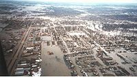
history. The Grand River went above bankfull on the night of March 24, rising slowly for the next four days. It broke the previous high water mark by over 60 cm (2 ft), and was considered a once in 100 year flood. Over one-half of the population on the west side of the river was inundated. On the east bank of the river, numerous factories went underwater. There was one casualty. Damages totaled US$1.8 million (1904 dollars). To the left is an image showing the flooding in Battle Creek
.
to Ione
in the Sierra Nevada foothills. An area of 300000 acres (1,214.1 km²) was flooded in the Sacramento Valley
.
, Monongahela
, and Ohio
rivers to swell out of their banks, leading to a flood of record in Pittsburgh. Damage to the city was estimated at US$5 million (1907 dollars). The death toll was low, with 6–12 perishing during the inundation.
flooded Albion
when the Homer Dam broke around 3 p.m. on March 7. By midnight, the bridges surrounding town were underwater. Six buildings in Albion collapsed, which caused over US$125,000 in damage (1908 dollars).
basin
. LaPorte
, in the Feather River basin, had 1458 mm (57.4 in) of rain in 20 days, an event with a return period of 12,000 years. The flood episodes of 1907 and 1909 in California resulted in an overhaul of planned statewide flood control designs.
Austin, Pennsylvania
Heavy rains filling the Bayless reservoir cracked the concrete dam, sending an estimated 450,000,000 gallons downstream destroying most of the boroughs of Austin and Costello. A total of 78 people from Austin and 2 from Costello perished during the inundation.
Ohio
Nearly 254 mm (10 in) of rain during a series of three winter storms led to this flood event, which affected southwest, central, and eastern Ohio, especially cities and towns along the Great Miami River
and Olentangy River
valleys, as well as Indianapolis
, eastern Indiana, and western Pennsylvania. Fires and tornadoes also wrought destruction.
was totally devastated, being inundated for three days in late March. The floods also put the Ohio and Erie Canal
out of business for good, destroying most of the locks and many miles of embankments. The death toll from this flood was 361 with total damages of US$100 million.
, 50–75 perished when a break in the levee allowed a 7 feet (2.1 m) wall of water to sweep through downtown. Five of the town's bridges washed away.
The state capital, Columbus
, suffered its worst ever flooding from the Olentangy and Scioto
rivers. The Franklinton
area on the west side was inundated after a levee broke on March 25. Four thousand houses were damaged or destroyed, between 90 and 100 lives were lost, and three of four bridges spanning the Scioto River downtown were destroyed (only the Rich Street bridge survived – Town, State and Broad street bridges were destroyed). The owner of The Columbus Dispatch
, Robert F. Wolfe
, chartered interurban trains to Buckeye Lake some 48 km (29.8 mi) east of Columbus to retrieve boats to rescue survivors. Flooding also occurred along Alum Creek
on the city's east side.
, Scioto River flooding carved out a 2–3 m (6.6–9.8 ft) deep channel on Hickory Street. 18 lost their lives in the town.
The Ohio River
reached a level of 21 m (68.9 ft) near Higginsport
.
coast, which caused torrential rains across it and adjacent states; rains from this storm affected Southern states as far north as North Carolina
and Tennessee
.
Another tropical storm passed over Charleston, South Carolina
, during the morning of July 14, 1916, and passed to the northwest. It hit the Carolinas hard, especially western North Carolina (July 15) and northwestern South Carolina.
All previous records for 24-hour rainfalls were exceeded, and rivers and streams throughout the area rose past all previously recorded levels. The resulting flooding was disastrous, and approximately 80 people were killed and property damage was estimated at 25 million dollars.
Ohio River
Ice jams due to a quick thaw led to this flood. The river stage at Cincinnati climbed to near 19 m (62.3 ft) during the event. Ice blocks in the river destroyed steamboat
s on the river, ending the era of steamboat commerce on the Ohio River.
, with a total of 215 fatalities. On September 9 and 10, 1921, the remnants of a hurricane moved over Williamson County
. The center of the storm became stationary over Thrall
, dropping a storm total of 39.7 inches (100.8 cm) of rain in 36 hours.
The 24-hour rainfall total ending 7 AM on September 10, 1921 (38.2 inches) at a U.S. Weather Bureau station in Thrall remains the national official 24-hour rainfall record.
Eighty-seven people drowned in and near Taylor
, and 93 in Williamson County. Thrall rainfall was 23.4 inches (59.4 cm) during 6 hours, 31.8 inches (80.8 cm) during 12 hours, and 36.4 inches (92.5 cm) during 18 hours.
Great Mississippi Flood of 1927
From the summer of 1926 into the spring of 1927, heavy rains much greater than normal saturated the ground throughout eastern Kansas
, Oklahoma
, and the Ohio Valley. The White
and Little Red rivers broke through the levees in Arkansas
in February, flooding over 400 km² (98,842.1 acre) with 3 to 5 m (9.8 to 16.4 ft) of water. The first levee break along the Mississippi River
occurred a few miles south of Elaine, Arkansas
on March 29.
Over the next six weeks, numerous levees broke along the Mississippi River from Illinois
to Louisiana
, which inundated numerous towns in the Mississippi Valley. The break at Mounds Landing near Greenville, Mississippi
, was the single greatest crevasse to ever occur along the Mississippi River. It single-handedly flooded an area 80 km (49.7 mi) wide and 160 km (99.4 mi) long with up to 6 metres (19.7 ft) of water. Heavy spring rains caused a second major flood in the same region that June. In all, 73500 km² (28,378.5 sq mi) which were home to more than 931,000 people were inundated. The flood finally subsided in August. The massive Red Cross relief effort was directed by then Secretary of Commerce Herbert Hoover
, which later catapulted him into the presidency and made the New Deal
a reality within the next decade.
In order to avoid flooding the city of New Orleans, the governor of Louisiana
allowed engineers to create the Poydras cut, which saved the city but led to the flooding of St. Bernard
and Plaquemines
parishes instead. Millions of acres across seven states were flooded. Evacuees totaled 500,000. Economic losses were estimated at US$1 billion (1927 dollars), which was equivalent to almost one-third of the federal budget at that time.
. Vermont
was where most of the death and damage was seen during this flood; local rainfall totals reached upwards to near 375 mm (14.8 in). In New Hampshire
, the Pemigewasset
, Baker
, Ammonoosuc
, Merrimack
and Connecticut
rivers went into flood. Along the Androscoggin River
in Maine
, floods destroyed the covered bridge in Bethel
. A steel bridge replaced the old bridge to accommodate truck traffic across the river. Life was also disrupted in Rumford from this flood
. Damages from the flood totaled US$40 million (1927 dollars). Eighty-five people lost their lives in the flood, including Vermont's Lt. Gov. Samuel Hollister Jackson.
 Rain concurrent with snowmelt set the stage for this flood
. It affected the entire state of New Hampshire
. In Maine
, a major flood washed out railroad tracks along the Androscoggin River
east of Bethel
and the industrial section of Rumford. Jay
saw its mills and factories along the river damaged. The East Turner
bridge was again destroyed. The iron bridge between Lisbon Falls
and Durham
washed away. Along the Kennebec River
, the Ticonic bridge was washed downstream at Waterville, Maine
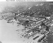
. In all, damage totaled US$113 million (1936 dollars), and 24 people were killed. Damage was significant along the C&O Canal during the greatest of all Potomac River
floods. The flood carried off many of the bridges along the Potomac from Harpers Ferry, West Virginia
to Hancock, Maryland
.
, during the 1936 spring floods, the Merrimack River
exceeded its banks, causing havoc in most of the city's northern banks. The Francis Gate
saved the downtown area, but other sections of the city were not so lucky.
Lowell had a second, lesser flood in 1938. This flood prompted the federal government to assume responsibility for flood control throughout the country.
Ohio
A significant flood struck the region. At Cincinnati, the flood peaked twice within three months, first on January 14. The river stage nearly reached 21 m (68.9 ft). Cincinnati experienced a double disaster as 10 or more gas tanks exploded on "Black Sunday", January 24, which led to oil fires on the Ohio and in Mill Creek Valley. Two days later, the Ohio River crested in Cincinnati at a record 24.381 m (80 ft). Flooding in the city lasted 19 days. In Kentucky
, one-third of Kenton
and Campbell
counties were submerged. The cities of Louisville
, Owensboro
, Paducah
, and others were disastrously inundated. In Indiana
, Aurora
was inundated. In Ohio, Higginsport
was almost completely submerged during the flood, along with Columbus
, Dayton
, Hamilton
, and Middletown
. Damages totaled US$20 million (1937 dollars).
Santa Ana
The storm of February 4–7, 1937, resulted in the highest four-day rainfall totals at several stations in the Santa Ana River
basin
. The Riverside
north station had over 200 mm (7.9 in) of rain in that four days, which equaled a 450-year event.
Northeast California
The storm of December 1937 was a high elevation event in the northeast corner of the state.
Los Angeles Flood of 1938
Two significant cyclones moved through the region; one between February 27 and March 1 and the second between March 1 and March 3. Over 254 mm (10 in) of rain had fallen during the five day period. Massive debris flows moved out from the San Gabriel Mountains
into the Los Angeles Basin
. Although Los Angeles County
experienced damage, Riverside
and Orange
counties bore the brunt of the flooding. A total of 5601 homes were destroyed, and an additional 1500 homes were left uninhabitable. The three transcontinental railroads connecting Los Angeles to the outside world experienced washed out bridges and flooded lines, isolating the city. Mail service after the flood was conducted by the U.S. Coast Guard. The death toll was 115. It was the region's worst flood since New Year's Day of 1934. The result of this flood was the Flood Control Act of 1941, which authorized the U.S. Army Corps of Engineers to build a series of concrete sewers.
Oklahoma
Floods of record occurred on the Sulphur
, Sabine
, Red
, Ouachita
, and Little
rivers during this event. It helped spur reservoir construction on these rivers in the 1950s and 1960s.
Michigan
Snow fell the previous month across Michigan
. A pair of frontal zones brought heavy rains to the lower peninsula of Michigan during the first several days of the month. Rainfall amounts of 126 mm (5 in) were measured at Jackson
with a larger area of 75 mm (3 in) falling between Benton Harbor
and Detroit. The heavy rain melting the existent snowpack increased runoff, and frozen ground across the region did not help matters. Flooding was witnessed from April 4 to April 11 and it was considered the worst flood since 1904 for the region. The Kalamazoo
, Grand
, Saginaw
, St. Clair
, Clinton, and River Rouge
river basins were impacted by this inundation, which was generally considered a once in 50 year event. Damage totaled US$4 million (1947 dollars).
Great Flood of 1951
This event was the worst in Kansas since June 1903. Small rivers and creeks were running at bankfull over eastern Kansas when rainfall up to 254 mm (10 in) in 12 hours the last few days of June and the first few days of July caused rivers in Kansas to flood. After a break in the rainfall on July 4, heavy rains returned on July 5. At Manhattan, Kansas
, at the intersection of the Big Blue River
and Kansas River
, flooding inundated 70 city blocks with water up to the second floor of stores along Main Street. The high waters moved downstream to Topeka
, forcing 20,000 persons to evacuate, then on to Lawrence
, causing their worst flood up to that time. The industrial districts which border the Kansas River in Kansas City
were protected by a 10 m (32.8 ft) dike which was equipped with floodgates at each tributary and topped by an 2.4 m (7.9 ft) wall, which was designed to manage a flood 1.5 m (4.9 ft) higher than the June 1903 flood
. The onset of floodwaters reached Kansas City, Kansas on July 12, and the Kansas River rose rapidly, reaching its peak stage on July 14. Water rose 15 cm (5.9 in) an hour until within a meter (3 ft) of the top of the dike. The piers of bridges were battered by debris and whole farmhouses which had been swept downstream. Weak areas of the levee were reinforced with the help of hundreds of workers sandbagging. Shortly before midnight July 13, the Kansas River broke the levee protecting the Argentine district, and residents were forced to flee to nearby bluffs. Early that morning, after the Armourdale district had been evacuated, a 6 km (3.7 mi) long wave of water began to cascade over the levee and inundated the district with 4.5 to 9 m (14.8 to 29.5 ft) of water. Many people were rescued by boats, out of trees, ledges and rooftops. Later that morning, the Central Industrial District was flooded even while Mayor Roe Bartle of Kansas City, Missouri
was on an aerial inspection of the flood scene.
 The livestock industry was paralyzed as packing plants were flooded and thousands of hogs and cattle were swept away. Floodwaters made a canal out of Southwest Boulevard. A 23,000-liter (6,000-gallon) oil tank, caught in the current, struck a high tension wire and exploded, causing additional mayhem. The burning oil ignited the Phillips Petroleum Company oil tanks, which went up with a roar that rocked downtown Kansas City. Soon, eight city blocks were aflame as dozens of oil tanks exploded in a chain reaction that lasted five days. The Hannibal Bridge and A.S.B. Bridge were the only two highway bridges still operating. Several barges were torn loose and caught in the current about a kilometer (0.5 mi) upstream from the Hannibal Bridge. These barges threatened to destroy the remaining bridges but, fortunately, two of the barges arrived at the Hannibal Bridge at the same time and wedged against the bridge. The barges were quickly secured to the bridge with chains.
The Missouri River
and the Kansas River
threatened to spill into the Municipal (now Downtown) Airport, the Fairfax District, and North Kansas City
that Friday night. Planes were evacuated, and North Kansas City residents were ordered to leave immediately. Thousands of men, with the help of trucks and bulldozers, worked through the night to support the dike, but the collapse of the Jersey dike early July 15 was the last straw as water began to pour into the Fairfax District. In anticipation of such a break, a second levee had been started in order to protect the Quindaro Utility Plant in the northwest corner of the district. The plant supplied water and electricity to more than 130,000 customers in Kansas City, Kansas. Shutting down the plant would have been disastrous as water hitting the 1100 °C (2,012 °F) boilers would lead to a devastating explosion. Workers virtually removed a nearby clay hill in their efforts to build up and support the dike. By 4 AM Saturday, the dike was within 30 cm (0.984251968503937 ft) of being topped as the flood had crested. By Monday, waters were receding as fast as they had come up.
The flood caused more than one billion dollars (1951 dollars) and claimed 41 lives in the Midwest. In Kansas City only three persons drowned, but property damage was $870 million dollars. Of the five industrial districts only North Kansas City was completely saved. The airport and the Quindaro plants were also spared from the worst.
California
The storm affected the Central Sierra and South Bay areas. The Eel River
on the North Coast saw the greatest flow of record to that time, while Central Valley rivers saw near record flows. A statewide disaster was declared, and the storm resulted in 74 deaths and $200 million in economic losses. The heaviest 24-hour rainfall was recorded on December 20 when 389 mm (15.3 in) fell in Shasta County.
and Westfield River
in August 1955 killed at least 87 people. The flood produced $8 million dollars in damages, or over $100 million by today's standards.
in two time periods; April 24 to April 26 and May 7 until May 12. The two rain events led to 75–150 mm (3–5.9 in) of rain falling across northern Michigan over this three week period. Residual snowpack in forested areas added to its effects. It was considered a once in 25–50 year event for much of the area, although many of the records set during this event stand today. Damage totaled US$575,000 (1960 dollars).
New Hampshire
This flood
struck the Merrimack
and Piscataquog
rivers. It was the third highest flood on record in these areas.
California
The Columbus Day
storm brought high winds and record breaking rains. Rains fell from Oakland
to Alturas
with record-setting three-day rainfall for Lake Spaulding of 585.5 mm (23.1 in). One hundred seventy-four gage stations recorded their highest three day rainfall totals to that time. The storm caused $4 million in damages.
caused a tsunami
in March 1964, which completely devastated the downtown district of Crescent City
on the North Coast, resulting in 11 deaths and an economic loss of $14 million in Del Norte County
alone. It was by far the worst damage done to any town in the contiguous United States by a tsunami. Substantial damage and numerous deaths also occurred in the towns of Valdez
, Whittier
, Chenega
, Seward
, Kodiak
, Kalsin Bay and Kaguyak, Alaska, and Port Albini, British Columbia. Four children were swept to their deaths from a beach near Newport, Oregon
, and lesser damage occurred all along the coast as far south as San Diego.
was submerged under 3 metres (9.8 ft) of flood waters during the event. This flooding prompted flood control measures to be built along the Willamette River
. This major flood between December 18, 1964 and January 7, 1965, also impacted portions of southwest Washington, Idaho
, Nevada
, and especially northern California
. In Oregon seventeen people died as a result of the disaster, and it caused hundreds of millions of dollars in damage. The flooding covered 152789 acre. The National Weather Service
rated the flood as the 5th most destructive weather event in Oregon in the 20th century.
April 1965 flood
 The 1965 flood caused over five million dollars of damage in Clinton, Iowa
, alone.
July 4, 1969 Flood
The Independence Day
flood of 1969 was one of the worst in Ohio
history, caused by 355 mm (14 in) of rain in 12 hours. This caused three large dams to fail, much property damage, and loss of life. Wayne County
was one of the worst-affected areas.
Hurricane Camille
On the night of August 19 into August 20, the remains of Camille stalled due to high pressure in central Virginia. Within eight hours, at least 710 mm (28 in) of rain fell. This resulted in one of the worst natural disasters for Virginia
in its 400 years of history. Debris flows and severe flooding claimed 150 lives, mainly from Nelson County
.
Southeast Oklahoma
Rainfall up to 406 mm (16 in) fell across the Little River
basin. The Glover River
rose high enough to deposit area cattle in trees. The Little River flooded tens of thousands of acres. This flood occurred after major reservoirs were built on these basins.
Buffalo Creek Flood
The Buffalo Creek Flood was a disaster that occurred on February 26, 1972, when the Pittston Coal Company's coal slurry impoundment dam #3, located on a hillside in Logan County, West Virginia, USA, burst four days after having been declared 'satisfactory' by a federal mine inspector. Out of a population of 5,000 people, 125 were killed, 1,121 were injured, and over 4,000 were left homeless.
Rapid City, South Dakota Flood
A frontal zone was banked up against the Black Hills
of South Dakota
on the morning of June 9. Heavy rainfall, with amounts of nearly 381 mm (15 in) near Keystone
, mainly between 6 pm and midnight. Rapid Creek
overflowed at 10:15 pm. Canyon Lake Dam failed at 10:45 pm, adding to the flood's magnitude. The flood crest, reached around 12:15 am, ravaged Rapid City and surrounding canyons. The death toll was 238.
The Rapid City Public Library
hosts a more comprehensive digital archive of Flood-related stories, photos and news accounts on their 1972 Flood page.
Hurricane Agnes
Agnes moved into the coast of the Florida panhandle
as a weak hurricane. Weakening into a tropical depression over Georgia
, a major trough in the Westerlies
approached the cyclone, which subsequently strengthened Agnes over land back into a tropical storm in North Carolina
, although it also developed a more western cyclone. The two moved in tandem, with Agnes moving offshore Norfolk, Virginia
and becoming a strong tropical storm. Eventually, the western nontropical low wrapped Agnes inland, which was then absorbed over Connecticut
. These cyclones led to 150–254 mm (5.9–10 in) of rain over North Carolina, with 254–483 mm (10–19 in) falling across the remainder of the Mid-Atlantic states
. The flood unleashed by the system was the greatest natural disaster in damages for the United States up until that time.
. In early April, a foot/30 cm of snow fell across the region. Intense rainfall on April 18 and April 19 of 75–125 mm (3–4.9 in) fell over a short time frame into the residual snowpack, increasing the magnitude of the flood. The flood peaked between April 19 and April 22, primarily in the Kalamazoo
, Grand
, Flint
, and Shiawassee River
basins. The recurrence interval for this kind of flood is 50–100 years. Lansing
and Flint
saw the most damage, which overall totaled US$50 million (1975 dollars).
Big Thompson
Moist easterly flow went up the terrain, forming thunderstorm
s beginning at 6 pm and lasting to 9 pm on July 31. 200 mm (7.9 in) of rain fell in one hour, with over 300 mm (0.984251968503937 ft) falling during the event. A 5.8 m (19 ft) high fall of water swept down the canyon, taking everything in its path downstream. It was one of the deadliest freshwater floods in U.S. history, as 143 people perished during the flash flood
. Houses destroyed totaled 418. Overall damage was US$40 million (1976 dollars). In the aftermath of the storm, regulations were passed to limit development in similar canyons.
area on the night of September 12, 1977. The flood caused 25 deaths and between $80 and $100 million in damages.
skirted the lower Texas
coast and went ashore south of Corpus Christi
during the night of the July 30/July 31. The circulation was followed inland west of San Antonio on August 1 before becoming diffuse. Rainfall increased despite the lack of a surface circulation, and disastrous flooding occurred in many south Texas
river basins, including the Guadalupe River
and its tributaries. Extensive damage occurred, and 30 people lost their lives in the flood. The maximum rainfall total in Texas occurred in Medina
, where 1219 mm (48 in) of rain was deposited due to mesoscale convective systems firing along a frontal
boundary induced by Amelia's remnant circulation aloft.
Basin since 1927. Red River Landing, Louisiana
, was flooded for 115 days. Damages totaled US$15.7 million (1983 dollars).
 In the winters of 1983, Utah received record precipitation. This swelled City Creek, which flows through Salt Lake City via underground conduits. On May 28, debris clogged the conduits, causing the creek to overflow on State Street, one of the main thoroughfares of the city. Aggressive sandbagging managed to divert the flood waters to other underground rivers via State Street, but temporary pedestrian bridges were needed for several weeks. The Great Salt Lake
in succeeding years reached a record high water level, flooding Saltair
and other areas and causing traffic problems on I-80
.
to the west of the area, which led to over 175 mm (6.9 in) of rain in the Blue Ridge Mountains
, though less than 25 mm (0.984251968503937 in) to the Mountain State
. After Juan passed by, an occluded system moved slowly northward from the Gulf of Mexico
through the Mid-Atlantic States
during the first days of November, leading to significant rainfall for the central Appalachians
. Local amounts of 508 mm (20 in) of rain were reported from West Virginia
, worse than the flooding the state witnessed in 1888. This led to debris flows and widespread damage in the Upper Potomac River
basin and Cheat River
Basin in West Virginia and Virginia
. Damage was severe where the South Branch joins the North Branch of the Potomac. The Paw Paw Tunnel
was flooded. The death toll was 50 from West Virginia.
Northern California
On February 11, a vigorous low pressure system drifted east out of the Pacific, creating a pineapple express
that lasted through February 24 unleashing unprecedented amounts of rain on northern California and western Nevada. The nine-day storm over California constituted half of the average annual rainfall for the year. Record flooding occurred in three streams that drain to the southern part of the San Francisco Bay
area. Extensive flooding occurred along the Napa
and Russian
rivers. Napa
, north of San Francisco, recorded their worst flood to this time while nearby Calistoga
recorded 736 mm (29 in) of rain in 10 days, creating a once-in-a-thousand-year rainfall event. Records for 24 hour rain events were reported in the Central Valley and in the Sierra Nevada. One thousand-year rainfalls were recorded in the Sierras. The heaviest 24-hour rainfall ever recorded in the Central Valley at 447 mm (17.6 in) occurred on February 17 at Four Trees in the Feather River
basin
. In Sacramento
, nearly 254 mm (10 in) of rain fell in an 11-day period. System breaks in the Sacramento River
basin
included disastrous levee
breaks in the Olivehurst
and Linda
area on the Feather River
. Linda
, about 65 km (40.4 mi) north of Sacramento, was devastated after the levee broke on the Yuba River
's south fork, forcing thousands of residents to evacuate. In the San Joaquin River
basin
and the Delta, levees breaking along the Mokelumne River
caused flooding in the community of Thornton
and the inundation of four Delta islands. Lake Tahoe
rose 15 cm (5.9 in) as a result of high inflow. The California flood resulted in 13 deaths, 50,000 people were evacuated and over $400 million in property damage. Three thousand residents of Linda joined in a class action lawsuit, Paterno v. State of California, which eventually reached the California Supreme Court in 2004. The California high court affirmed the District Court of Appeal's decision that said California was liable for millions of dollars in damages.
Michigan
A slow-moving storm system moved from the central Plains
into the Great Lakes
. Rainfall amounts by September 10 were 200–330 mm (7.9–13 in) over a two day period. Damage was unprecedented. Dam failure abounded with a total of 14 dams undermined and an addition 19 dams at risk during the event. Four major bridges failed. Thousands of acres of sugar beets, beans, potatoes, corn, and other vegetables were in ruin. A total of six people perished during the flood. Damage totaled US$500 million (1986 dollars), and 30 counties were declared Federal disaster areas.
Androscoggin River
The largest and most destructive flood in the history of this Maine
river occurred due to four days of rained combined with melting snow and ice flows. Hardest hit areas included Lewiston
, Rumford, and Mexico. Jay's
industrial section was inundated.
Great Flood of 1993
Soils became saturated in the fall of 1992 across the Midwest. Numerous rounds of showers and thunderstorms from mid-June into August led to significant flood
ing. Over 1000 mm (39.4 in) of rainfall fell in isolated spots. Some areas of the Mississippi Valley were flood
ed for over 200 days, leading to destruction spread across nine states. This was the flood of record along many of the streams and rivers that feed the Mississippi and Missouri
rivers. Around 60,000 homes were damaged or destroyed. The death toll was 50, and damage totaled US$15 billion (1993 dollars).
The result of this flood was an aggressive campaign by the federal government to buy out flooded agricultural land from willing sellers.
Tropical Storm Alberto (1994)
This tropical cyclone
made landfall in the Florida Panhandle
before stalling south of Atlanta, Georgia. Flooding was near or at record levels for the Flint
, Ocmulgee
, Chattahoochee
, Choctawhatchee
, and Apalachicola
rivers. Americus, Georgia
saw the heaviest rain in a 24 hour period, when 536 mm (21.1 in) was recorded. The death toll was 33, with two-thirds coming from people driving into flooded areas. Thousands of homes were destroyed. Damage totaled US$750 million (1994 dollars).
California
During the events of January and March 1995, over 100 stations recorded their greatest 1-day rainfalls in that station’s history. The major brunt of the January storms hit the Sacramento River
basin and resulted in small stream flooding primarily due to storm drainage system failures, though flooding affected nearly every part of the state. The Salinas River
exceeded its previous measured record crest by more than 1.3 m (4.3 ft), which was within 30–60 cm (0.984251968503937–2 ft) of the reputed crest of the legendary 1862 flood. The Napa River
set a new peak record, and the Russian
and Pajaro
rivers approached their record peaks. More than thirty people were killed and 5 were missing.The flood cost $1.8 billion.
May 8th 1995 Louisiana Flood
A stalled front led to excessive rains across southeast Louisiana
. Rainfall up to 500 mm (19.7 in) fell across the Crescent City, with 250 mm (9.8 in) falling within a six hour period. Seven lives were lost, 35,000 homes were flooded along with thousands of businesses across southeast Louisiana. Damage estimates were around US$1 billion (1995 dollars).
had received two to three times their average precipitation
since December 1. Significant snowpack was in place on January 18. Then, a period significant warming took place across the East, mainly during a 30 hour period, which led to ice jam floods across western Pennsylvania
and New York
. Surface dew points rose into the 50s and 60s Fahrenheit/teens Celsius, which rapidly melted the snowpack. Then, a heavy rain event occurred along a frontal zone moving in from the west, which led to 25–27 mm (0.984251968503937–1.1 in) of rainfall between January 18 and January 19. Some areas lost 30–60 cm (0.984251968503937–2 ft) of snow in only 12 hours, which led to the bulk of the flooding.
The Ohio
and Susquehanna
rivers experienced their highest river crests since Hurricane Agnes
and Hurricane Eloise
. The Delaware River
at Trenton, New Jersey
saw its highest crest since Hurricane Connie
and Hurricane Diane
moved by in 1955. The South Branch of the Potomac, as well as the Cheat
and Monongahela
rivers in West Virginia
and Pennsylvania
experienced their highest levels since early November 1985, which was the flood of record for the region. A total of 33 people died during the event, with 18 from Pennsylvania and 9 from New York. It was the worst flood event for the Mid-Atlantic states
as a whole since 1985.
Willamette Valley Flood of 1996
This was the biggest flood
for the region since December 1964. Heavy logging had occurred across the region in the previous 30 years. Above normal rainfall had been occurring since November 1 of 1995, which led to significant snowpack in the mountains by late January. Western Oregon
then experienced a 150–300 mm (5.9–11.8 in) of rainfall on February 5 to February 7, which in combination with temperatures rising into the 60s Fahrenheit/upper teens Celsius led to the flood.
led to extreme rains across New England
. Factories and mills in Lawrence
, Haverhill
, and Lowell, Massachusetts
were severely impaired during the event. A total of 81 bridges needed to be rebuilt after the flood. A large portion of Hartford, Connecticut
was submerged.
Northern California
A series of tropical storms collectively called a pineapple connection
, hit northern California from late December 1996 to early January 1997. December 1996 was one of the wettest Decembers on record. The Klamath River
on California's North Coast experienced significant flooding which led to the river permanently changing course in some areas. The Klamath National Forest
experienced its worst flood since 1974. Unprecedented flows from rain surged into the Feather River
basin while melted snow surged into the San Joaquin River
basin. Rain fell at elevations up to 3300 metres (10,826.8 ft), prompting snow melt. With these warm weather storms generally comes large amounts of snow melt. The Cosumnes River
, a tributary
to the San Joaquin River, bore the brunt of the flooding. Sacramento
was spared, though levee
failures flooded Olivehurst
, Arboga
, Wilton
, Manteca
, and Modesto
. Massive landslides in the Eldorado National Forest
east of Sacramento closed Highway 50
. Damages totaled US$35 million (1997 dollars). Watersheds in the Sierra Nevada were already saturated by the time three subtropical storms added more than 760 mm (29.9 in) of rain in late December 1996 and early January 1997. Levee failures due to breaks or overtopping in the Sacramento River
basin resulted in extensive damages. In the San Joaquin River
basin, dozens of levees failed throughout the river system and produced widespread flooding. The Sacramento – San Joaquin River Delta also experienced several levee breaks and levee overtopping. 48 counties were declared disaster areas, including all 46 counties in northern California. Over 23,000 homes and businesses, agricultural lands, bridges, roads and flood management infrastructures – valued at about $2 billion – were damaged. Nine people were killed and 120,000 people were evacuated from their homes. Three hundred square miles were flooded, including the Yosemite Valley
, which flooded for the first time since 1861–62.
and southern Ohio
between March 1 and March 3. A total of six states were impacted by the event. Record flooding was witnessed along most rivers in northern Kentucky, surpassing that of 1937. Near-record flooding was recorded in Ohio, mainly along Brush Creek and the Scioto
and Great Miami
rivers. Eastern sections of Higginsport
went underwater, leaving only one route in and out of town. It was Ohio's worst flood in 30 years. The death toll from the event was 33, with 21 lives lost in Kentucky and 5 lost in Ohio. Hundreds were injured.
, with 297 cm (116.9 in) falling at Fargo, North Dakota
. During the spring thaw, this creates problems as it is usually colder in southern Canada, which makes ice jam flooding a major concern for this river basin. Starting in early February, a major flood was anticipated, over two months before the flood. This gave the region plenty of time to sandbag the nearby dikes. The river began rising on April 4, and flooding the area on April 18 as the flood waters rose up to 1.5 m (4.9 ft) above the long term prediction. Dikes gave way, and Grand Forks
was inundated. Between 75–90% of the residents had been evacuated prior to this time. Fires began to break out on the 19th as electric lines shorted out, which destroyed 11 buildings in downtown. The river and associated flood waters began to recede on April 23.
of the Rockies
forced dewpoint temperatures to around 16 °C (60.8 °F). By 5 pm local time, thunderstorms began to erupt. Within 30 minutes, local amounts of 50 mm (2 in) had fallen near Laporte
and Livermore
, with 50 mm (2 in) more falling near Loveland
before the storm weakened around 8 pm. South of Fort Collins
, new thunderstorm development began around 10 pm, which spread north through the city, dumping another 12 mm (0.47244094488189 in) of rain before dissipating. Around midnight on July 28, upslope flow increased behind a cold front that triggered the initial thunderstorms. Steady rains began around 1 am, ending for the most part around 4 am for much of the region except for a narrow swath including Fort Collins, where rains continued towards 7 am. However, rains renewed across the region between 8 am and noon. An additional 150–200 mm (5.9–7.9 in) of rain had fallen near Laporte. By that evening, thunderstorms redeveloped. Starting at 7 pm, heavy rains fell at Colorado State University
. Between 8:30 and 10 pm, very heavy rains struck Fort Collins again. A total of over 250 mm (9.8 in) fell during this time frame, which brought storm totals to 368 mm (14.5 in) in southwest Fort Collins. The ensuing flooding of Spring Creek caused a freight train to derail and completely destroyed two mobile home parks. Damage totaled in the hundreds of millions of dollars. This flood event helped spawn a developing rainfall mesonet for the United States, known as CoCoRAHS, which was anticipated to help detect ongoing flash flood events in real-time.
, which led to the flood of record in southern Texas. A total of 31 perished during the event, 17 of which were found in flooded vehicles. Damage approached US$750 million (1998 dollars).
Hurricane Floyd
The antecedent conditions included the passage of Tropical Storm Dennis
through the Mid-Atlantic states during the first week of September. Only 10 days later, the combination of a stalled frontal zone, strong dynamics aloft, and a hurricane moving up the East Coast led to excessive rainfall from North Carolina
northward up the Eastern Seaboard
between September 14 and September 17, with amounts of near 508 mm (20 in) being reported near Wilmington, North Carolina
, and 150–300 mm (5.9–11.8 in) falling farther up the coast. It was the most damaging flood in the history of North Carolina
. In New Jersey
, the Raritan River
and other rivers went over their banks, causing flooding in Bound Brook
and New Brunswick
, among other places. In New Hampshire
, the storm flooded Belknap
, Cheshire
, and Grafton
counties. Of the 57 deaths attributed to Floyd, 46 were due to drowning in the flood; 35 from North Carolina
alone. Damage estimates were near US$5 billion (1999 dollars).
Flood
A flood is an overflow of an expanse of water that submerges land. The EU Floods directive defines a flood as a temporary covering by water of land not normally covered by water...
s in the United States are generally caused by excessive rainfall, excessive snowmelt
Snowmelt
In hydrology, snowmelt is surface runoff produced from melting snow. It can also be used to describe the period or season during which such runoff is produced. Water produced by snowmelt is an important part of the annual water cycle in many parts of the world, in some cases contributing high...
, and dam failure. Below is a list of flood
Flood
A flood is an overflow of an expanse of water that submerges land. The EU Floods directive defines a flood as a temporary covering by water of land not normally covered by water...
events that were of significant impact to the country, between 1901 and 2000.
Heppner FloodHeppner Flood of 1903The Heppner Flood of 1903 was a major flash flood along Willow Creek responsible for destroying a large portion of Heppner, Oregon, United States, on June 14, 1903...
– June 1903
The third deadliest flash flood in US history, the normally placid Willow Creek burst its banks during an intense rain and hail storm. The city of HeppnerHeppner, Oregon
The city of Heppner is the county seat of Morrow County, Oregon, United States. It was originally called Standsbury Flat for George W. Standsbury, one of the first white settlers in the area. It was later renamed to honor Henry Heppner, a Jewish pioneer who opened the first general store there in...
, at the foothills of the Blue Mountains
Blue Mountains (Oregon)
The Blue Mountains are a mountain range in the western United States, located largely in northeastern Oregon and stretching into southeastern Washington...
in eastern Oregon, was almost completely destroyed. 220 of Heppner's 1,400 residents died in the flood.
Michigan Flood – March 1904
Flooding was more significant along the GrandGrand River (Michigan)
The Grand River is the longest river in the U.S. state of Michigan. It runs through the cities of Jackson, Eaton Rapids, Lansing, Grand Rapids, and Grand Haven.-Description:...
, Saginaw
Saginaw River
The Saginaw River is a river in the U.S. state of Michigan. It is formed by the confluence of the Tittabawassee and Shiawassee rivers southwest of Saginaw. It flows northward into the Saginaw Bay of Lake Huron just northeast of Bay City. The watershed area is .The river is an important shipping...
, Kalamazoo
Kalamazoo River
The Kalamazoo River is a river in the U.S. state of Michigan. The river is long from the junction of its North and South branches to its mouth at Lake Michigan, with a total length extending to when one includes the South Branch...
, and River Raisin
River Raisin
The River Raisin is a river in southeastern Michigan, United States that flows through glacial sediments into Lake Erie. The area today is an agricultural and industrial center of Michigan. The river flows for almost , draining an area of in the Michigan counties of Lenawee, Monroe, Washtenaw,...
river basins than the St. Joseph
St. Joseph River (Maumee River)
The St. Joseph River is an tributary of the Maumee River in northwestern Ohio, and northeastern Indiana in the United States, with headwater tributaries rising in southern Michigan. It drains a primarily rural farming region in the watershed of Lake Erie. It shares its name with the St...
and Huron River
Huron River (Michigan)
The Huron River is a river in southeastern Michigan, rising out of the Huron Swamp in Indian Springs Metropark in northern Oakland County and flowing into Lake Erie on the boundary between Wayne County and Monroe County...
basins. In Lansing
Lansing, Michigan
Lansing is the capital of the U.S. state of Michigan. It is located mostly in Ingham County, although small portions of the city extend into Eaton County. The 2010 Census places the city's population at 114,297, making it the fifth largest city in Michigan...
, it was the worst flood in the previous 135 years of its history. Many dams were either undermined or swept away. Kalamazoo
Kalamazoo, Michigan
The area on which the modern city stands was once home to Native Americans of the Hopewell culture, who migrated into the area sometime before the first millennium. Evidence of their early residency remains in the form of a small mound in downtown's Bronson Park. The Hopewell civilization began to...
saw two square miles of flooding during this event.
It was also considered the most destructive flood in Grand Rapids
Grand Rapids, Michigan
Grand Rapids is a city in the U.S. state of Michigan. The city is located on the Grand River about 40 miles east of Lake Michigan. As of the 2010 census, the city population was 188,040. In 2010, the Grand Rapids metropolitan area had a population of 774,160 and a combined statistical area, Grand...
history. The Grand River went above bankfull on the night of March 24, rising slowly for the next four days. It broke the previous high water mark by over 60 cm (2 ft), and was considered a once in 100 year flood. Over one-half of the population on the west side of the river was inundated. On the east bank of the river, numerous factories went underwater. There was one casualty. Damages totaled US$1.8 million (1904 dollars). To the left is an image showing the flooding in Battle Creek
Battle Creek, Michigan
Battle Creek is a city in the U.S. state of Michigan, in northwest Calhoun County, at the confluence of the Kalamazoo and Battle Creek Rivers. It is the principal city of the Battle Creek, Michigan Metropolitan Statistical Area , which encompasses all of Calhoun county...
.
California tropical storm – 1906
A tropical storm in late 1906 reported highest ever rainfalls in a southeast to northwest direction from MontereyMonterey, California
The City of Monterey in Monterey County is located on Monterey Bay along the Pacific coast in Central California. Monterey lies at an elevation of 26 feet above sea level. As of the 2010 census, the city population was 27,810. Monterey is of historical importance because it was the capital of...
to Ione
Ione, California
Ione is a city in Amador County, California, United States. The population was 7,918 at the 2010 census, up from 7,129 at the 2000 census. Once known as "Bed-Bug" and "Freeze Out," Ione was an important supply center on the main road to the Mother Lode and Southern Mines during the California Gold...
in the Sierra Nevada foothills. An area of 300000 acres (1,214.1 km²) was flooded in the Sacramento Valley
Sacramento Valley
The Sacramento Valley is the portion of the California Central Valley that lies to the north of the San Joaquin-Sacramento Delta in the U.S. state of California. It encompasses all or parts of ten counties.-Geography:...
.
Pittsburgh, Pennsylvania Flood – March 1907
Snowmelt combined with heavy rains by March 16 allowed the AlleghenyAllegheny River
The Allegheny River is a principal tributary of the Ohio River; it is located in the Eastern United States. The Allegheny River joins with the Monongahela River to form the Ohio River at the "Point" of Point State Park in Downtown Pittsburgh, Pennsylvania...
, Monongahela
Monongahela River
The Monongahela River is a river on the Allegheny Plateau in north-central West Virginia and southwestern Pennsylvania in the United States...
, and Ohio
Ohio River
The Ohio River is the largest tributary, by volume, of the Mississippi River. At the confluence, the Ohio is even bigger than the Mississippi and, thus, is hydrologically the main stream of the whole river system, including the Allegheny River further upstream...
rivers to swell out of their banks, leading to a flood of record in Pittsburgh. Damage to the city was estimated at US$5 million (1907 dollars). The death toll was low, with 6–12 perishing during the inundation.
Michigan Flood – March 1908
In February, snowstorms had deposited a significant snowpack across the region. Then, in early March, heavy rains and warmer conditions set in, setting the stage for a flood. The Kalamazoo RiverKalamazoo River
The Kalamazoo River is a river in the U.S. state of Michigan. The river is long from the junction of its North and South branches to its mouth at Lake Michigan, with a total length extending to when one includes the South Branch...
flooded Albion
Albion, Michigan
Albion is a city in Calhoun County in the south central region of the Lower Peninsula of the US state of Michigan. The population was 9,144 at the 2000 census and is part of the Battle Creek Metropolitan Statistical Area...
when the Homer Dam broke around 3 p.m. on March 7. By midnight, the bridges surrounding town were underwater. Six buildings in Albion collapsed, which caused over US$125,000 in damage (1908 dollars).
California Flood – 1909
The storm extended from Fort Ross on the coast to the Feather RiverFeather River
The Feather River is the principal tributary of the Sacramento River, in the Sacramento Valley of Northern California. The river's main stem is about long. Its length to its most distant headwater tributary is about . Its drainage basin is about...
basin
Drainage basin
A drainage basin is an extent or an area of land where surface water from rain and melting snow or ice converges to a single point, usually the exit of the basin, where the waters join another waterbody, such as a river, lake, reservoir, estuary, wetland, sea, or ocean...
. LaPorte
La Porte, California
La Porte is a census-designated place in Plumas County, California, United States. The population was 26 at the 2010 census, down from 43 at the 2000 census.-Geography:La Porte is located at ....
, in the Feather River basin, had 1458 mm (57.4 in) of rain in 20 days, an event with a return period of 12,000 years. The flood episodes of 1907 and 1909 in California resulted in an overhaul of planned statewide flood control designs.
Austin, PennsylvaniaAustin, PennsylvaniaAustin is a borough in Potter County, Pennsylvania, United States. The population was 623 at the 2000 census.-Geography:Austin is located at ....
Dam Failure – September 30 1911
Heavy rains filling the Bayless reservoir cracked the concrete dam, sending an estimated 450,000,000 gallons downstream destroying most of the boroughs of Austin and Costello. A total of 78 people from Austin and 2 from Costello perished during the inundation.OhioOhioOhio is a Midwestern state in the United States. The 34th largest state by area in the U.S.,it is the 7th‑most populous with over 11.5 million residents, containing several major American cities and seven metropolitan areas with populations of 500,000 or more.The state's capital is Columbus...
Flood – March 1913
Nearly 254 mm (10 in) of rain during a series of three winter storms led to this flood event, which affected southwest, central, and eastern Ohio, especially cities and towns along the Great Miami RiverGreat Miami River
The Great Miami River is a tributary of the Ohio River, approximately long, in southwestern Ohio in the United States...
and Olentangy River
Olentangy River
The Olentangy River is a tributary of the Scioto River in Ohio.It was originally called keenhongsheconsepung, a Delaware word literally translated as "stone for your knife stream", based on the shale found along its shores. Early settlers to the region translated this into "Whetstone River"...
valleys, as well as Indianapolis
Indianapolis
Indianapolis is the capital of the U.S. state of Indiana, and the county seat of Marion County, Indiana. As of the 2010 United States Census, the city's population is 839,489. It is by far Indiana's largest city and, as of the 2010 U.S...
, eastern Indiana, and western Pennsylvania. Fires and tornadoes also wrought destruction.
Dayton area
DaytonDayton, Ohio
Dayton is the 6th largest city in the U.S. state of Ohio and the county seat of Montgomery County, the fifth most populous county in the state. The population was 141,527 at the 2010 census. The Dayton Metropolitan Statistical Area had a population of 841,502 in the 2010 census...
was totally devastated, being inundated for three days in late March. The floods also put the Ohio and Erie Canal
Ohio and Erie Canal
The Ohio Canal or Ohio and Erie Canal was a canal constructed in the 1820s and early 1830s. It connected Akron, Summit County, with the Cuyahoga River near its mouth on Lake Erie in Cleveland, Cuyahoga County, and a few years later, with the Ohio River near Portsmouth, Scioto County, and then...
out of business for good, destroying most of the locks and many miles of embankments. The death toll from this flood was 361 with total damages of US$100 million.
Columbus area
On the Olentangy River, this flood broke the previous record for river stage by over 4.5 m (14.8 ft). In the town of Delaware, OhioDelaware, Ohio
The City of Delaware is a city in and the county seat of Delaware County in the United States state of Ohio. Delaware was founded in 1808 and was incorporated in 1816. It is located near the center of Ohio, is about north of Columbus, and is part of the Columbus, Ohio Metropolitan Area...
, 50–75 perished when a break in the levee allowed a 7 feet (2.1 m) wall of water to sweep through downtown. Five of the town's bridges washed away.
The state capital, Columbus
Columbus, Ohio
Columbus is the capital of and the largest city in the U.S. state of Ohio. The broader metropolitan area encompasses several counties and is the third largest in Ohio behind those of Cleveland and Cincinnati. Columbus is the third largest city in the American Midwest, and the fifteenth largest city...
, suffered its worst ever flooding from the Olentangy and Scioto
Scioto River
The Scioto River is a river in central and southern Ohio more than 231 miles in length. It rises in Auglaize County in west central Ohio, flows through Columbus, Ohio, where it collects its largest tributary, the Olentangy River, and meets the Ohio River at Portsmouth...
rivers. The Franklinton
Franklinton, Columbus, Ohio
Franklinton is a neighborhood in Columbus, Ohio. Lucas Sullivant, a Virginia born land surveyor, established Franklinton in 1797. It is bordered by the Scioto River on the north and east, Harmon Avenue on the east, Stimmel Road and Greenlawn Avenue on the south, and Interstate 70 on the west...
area on the west side was inundated after a levee broke on March 25. Four thousand houses were damaged or destroyed, between 90 and 100 lives were lost, and three of four bridges spanning the Scioto River downtown were destroyed (only the Rich Street bridge survived – Town, State and Broad street bridges were destroyed). The owner of The Columbus Dispatch
The Columbus Dispatch
The Columbus Dispatch is a daily newspaper based in Columbus, Ohio. Its first issue was published on July 1, 1871, and has been the only mainstream daily newspaper in the city since The Columbus Citizen-Journal stopped printing in 1985....
, Robert F. Wolfe
Robert F. Wolfe
According to biographies supplied by the Columbus Foundation and the Columbus Dispatch, newspaper founder Robert F. Wolfe arrived in Columbus, Ohio in 1888 and found work as a shoemaker, eventually beginning the Wolfe Brothers Shoe Company. In 1903, he bought the Ohio State Journal with his...
, chartered interurban trains to Buckeye Lake some 48 km (29.8 mi) east of Columbus to retrieve boats to rescue survivors. Flooding also occurred along Alum Creek
Alum Creek
Alum Creek is long creek that runs north to south in central Ohio. The creek originates in Morrow County and then flows through Delaware County and finally into Franklin County, where it ends at Big Walnut Creek, which drains into the Scioto River. In 1974, the Army Corps of Engineers completed...
on the city's east side.
Southern Ohio
In ChillicotheChillicothe, Ohio
Chillicothe is a city in and the county seat of Ross County, Ohio, United States.Chillicothe was the first and third capital of Ohio and is located in southern Ohio along the Scioto River. The name comes from the Shawnee name Chalahgawtha, meaning "principal town", as it was a major settlement of...
, Scioto River flooding carved out a 2–3 m (6.6–9.8 ft) deep channel on Hickory Street. 18 lost their lives in the town.
The Ohio River
Ohio River
The Ohio River is the largest tributary, by volume, of the Mississippi River. At the confluence, the Ohio is even bigger than the Mississippi and, thus, is hydrologically the main stream of the whole river system, including the Allegheny River further upstream...
reached a level of 21 m (68.9 ft) near Higginsport
Higginsport, Ohio
Higginsport is a village in Brown County, Ohio, United States, along the Ohio River. The population was 291 at the 2000 census.-Geography:Higginsport is located at ....
.
Southeast Floods – July 1916
On July 5–6, 1916, a tropical cyclone swept across the MississippiMississippi
Mississippi is a U.S. state located in the Southern United States. Jackson is the state capital and largest city. The name of the state derives from the Mississippi River, which flows along its western boundary, whose name comes from the Ojibwe word misi-ziibi...
coast, which caused torrential rains across it and adjacent states; rains from this storm affected Southern states as far north as North Carolina
North Carolina
North Carolina is a state located in the southeastern United States. The state borders South Carolina and Georgia to the south, Tennessee to the west and Virginia to the north. North Carolina contains 100 counties. Its capital is Raleigh, and its largest city is Charlotte...
and Tennessee
Tennessee
Tennessee is a U.S. state located in the Southeastern United States. It has a population of 6,346,105, making it the nation's 17th-largest state by population, and covers , making it the 36th-largest by total land area...
.
Another tropical storm passed over Charleston, South Carolina
Charleston, South Carolina
Charleston is the second largest city in the U.S. state of South Carolina. It was made the county seat of Charleston County in 1901 when Charleston County was founded. The city's original name was Charles Towne in 1670, and it moved to its present location from a location on the west bank of the...
, during the morning of July 14, 1916, and passed to the northwest. It hit the Carolinas hard, especially western North Carolina (July 15) and northwestern South Carolina.
All previous records for 24-hour rainfalls were exceeded, and rivers and streams throughout the area rose past all previously recorded levels. The resulting flooding was disastrous, and approximately 80 people were killed and property damage was estimated at 25 million dollars.
Ohio RiverOhio RiverThe Ohio River is the largest tributary, by volume, of the Mississippi River. At the confluence, the Ohio is even bigger than the Mississippi and, thus, is hydrologically the main stream of the whole river system, including the Allegheny River further upstream...
Flood – February 1918
Ice jams due to a quick thaw led to this flood. The river stage at Cincinnati climbed to near 19 m (62.3 ft) during the event. Ice blocks in the river destroyed steamboatSteamboat
A steamboat or steamship, sometimes called a steamer, is a ship in which the primary method of propulsion is steam power, typically driving propellers or paddlewheels...
s on the river, ending the era of steamboat commerce on the Ohio River.
Thrall Flood – September 1921
This storm caused the most deadly floods in TexasTexas
Texas is the second largest U.S. state by both area and population, and the largest state by area in the contiguous United States.The name, based on the Caddo word "Tejas" meaning "friends" or "allies", was applied by the Spanish to the Caddo themselves and to the region of their settlement in...
, with a total of 215 fatalities. On September 9 and 10, 1921, the remnants of a hurricane moved over Williamson County
Williamson County, Texas
Williamson County is a county located on both the Edwards Plateau to the west, consisting of rocky terrain and hills, and Blackland Prairies in the east consising of rich, fertile farming land, The two areas are roughly bisected by Interstate 35...
. The center of the storm became stationary over Thrall
Thrall, Texas
Thrall is a city in Williamson County, Texas, United States. The population was 710 at the 2000 census, and 847 in the 2005 census estimate. The name Thrall was chosen for the community to honor the Rev. Homer S. Thrall, a Methodist minister and historian much admired by local settlers and...
, dropping a storm total of 39.7 inches (100.8 cm) of rain in 36 hours.
The 24-hour rainfall total ending 7 AM on September 10, 1921 (38.2 inches) at a U.S. Weather Bureau station in Thrall remains the national official 24-hour rainfall record.
Eighty-seven people drowned in and near Taylor
Taylor, Texas
Taylor is a city in Williamson County, Texas, United States. The population was 13,575 at the 2000 census; it was 15,191 in the 2010 census estimate. Taylors largest employers include the Electric Reliability Council of Texas , Durcon Inc, and the T. Don Hutto Residential Center, an immigration...
, and 93 in Williamson County. Thrall rainfall was 23.4 inches (59.4 cm) during 6 hours, 31.8 inches (80.8 cm) during 12 hours, and 36.4 inches (92.5 cm) during 18 hours.
Great Mississippi Flood of 1927Great Mississippi Flood of 1927The Great Mississippi Flood of 1927 was the most destructive river flood in the history of the United States.-Events:The flood began when heavy rains pounded the central basin of the Mississippi in the summer of 1926. By September, the Mississippi's tributaries in Kansas and Iowa were swollen to...
From the summer of 1926 into the spring of 1927, heavy rains much greater than normal saturated the ground throughout eastern KansasKansas
Kansas is a US state located in the Midwestern United States. It is named after the Kansas River which flows through it, which in turn was named after the Kansa Native American tribe, which inhabited the area. The tribe's name is often said to mean "people of the wind" or "people of the south...
, Oklahoma
Oklahoma
Oklahoma is a state located in the South Central region of the United States of America. With an estimated 3,751,351 residents as of the 2010 census and a land area of 68,667 square miles , Oklahoma is the 28th most populous and 20th-largest state...
, and the Ohio Valley. The White
White River (Arkansas)
The White River is a 722-mile long river that flows through the U.S. states of Arkansas and Missouri.-Course:The source of the White River is in the Boston Mountains of northwest Arkansas, in the Ozark-St. Francis National Forest southeast of Fayetteville...
and Little Red rivers broke through the levees in Arkansas
Arkansas
Arkansas is a state located in the southern region of the United States. Its name is an Algonquian name of the Quapaw Indians. Arkansas shares borders with six states , and its eastern border is largely defined by the Mississippi River...
in February, flooding over 400 km² (98,842.1 acre) with 3 to 5 m (9.8 to 16.4 ft) of water. The first levee break along the Mississippi River
Mississippi River
The Mississippi River is the largest river system in North America. Flowing entirely in the United States, this river rises in western Minnesota and meanders slowly southwards for to the Mississippi River Delta at the Gulf of Mexico. With its many tributaries, the Mississippi's watershed drains...
occurred a few miles south of Elaine, Arkansas
Elaine, Arkansas
Elaine is a city in Phillips County, Arkansas, United States. The population was 865 at the 2000 census.-Geography:Elaine is located at .According to the United States Census Bureau, the city has a total area of , all of it land....
on March 29.
Over the next six weeks, numerous levees broke along the Mississippi River from Illinois
Illinois
Illinois is the fifth-most populous state of the United States of America, and is often noted for being a microcosm of the entire country. With Chicago in the northeast, small industrial cities and great agricultural productivity in central and northern Illinois, and natural resources like coal,...
to Louisiana
Louisiana
Louisiana is a state located in the southern region of the United States of America. Its capital is Baton Rouge and largest city is New Orleans. Louisiana is the only state in the U.S. with political subdivisions termed parishes, which are local governments equivalent to counties...
, which inundated numerous towns in the Mississippi Valley. The break at Mounds Landing near Greenville, Mississippi
Greenville, Mississippi
Greenville is a city in Washington County, Mississippi, United States. The population was 48,633 at the 2000 census, but according to the 2009 census bureau estimates, it has since declined to 42,764, making it the eighth-largest city in the state. It is the county seat of Washington...
, was the single greatest crevasse to ever occur along the Mississippi River. It single-handedly flooded an area 80 km (49.7 mi) wide and 160 km (99.4 mi) long with up to 6 metres (19.7 ft) of water. Heavy spring rains caused a second major flood in the same region that June. In all, 73500 km² (28,378.5 sq mi) which were home to more than 931,000 people were inundated. The flood finally subsided in August. The massive Red Cross relief effort was directed by then Secretary of Commerce Herbert Hoover
Herbert Hoover
Herbert Clark Hoover was the 31st President of the United States . Hoover was originally a professional mining engineer and author. As the United States Secretary of Commerce in the 1920s under Presidents Warren Harding and Calvin Coolidge, he promoted partnerships between government and business...
, which later catapulted him into the presidency and made the New Deal
New Deal
The New Deal was a series of economic programs implemented in the United States between 1933 and 1936. They were passed by the U.S. Congress during the first term of President Franklin D. Roosevelt. The programs were Roosevelt's responses to the Great Depression, and focused on what historians call...
a reality within the next decade.
In order to avoid flooding the city of New Orleans, the governor of Louisiana
Louisiana
Louisiana is a state located in the southern region of the United States of America. Its capital is Baton Rouge and largest city is New Orleans. Louisiana is the only state in the U.S. with political subdivisions termed parishes, which are local governments equivalent to counties...
allowed engineers to create the Poydras cut, which saved the city but led to the flooding of St. Bernard
St. Bernard Parish, Louisiana
St. Bernard Parish is a parish located southeast of New Orleans in the U.S. state of Louisiana. The parish seat is Chalmette, the largest city in the parish. As of 2000, its population was 67,229. It has been ranked the fastest-growing county in the United States from 2007 to 2008 by the U.S....
and Plaquemines
Plaquemines Parish, Louisiana
Plaquemines Parish is the parish with the most combined land and water area in the U.S. state of Louisiana. The parish seat is Pointe à la Hache...
parishes instead. Millions of acres across seven states were flooded. Evacuees totaled 500,000. Economic losses were estimated at US$1 billion (1927 dollars), which was equivalent to almost one-third of the federal budget at that time.
New England Flood – November 1927
A late-season tropical cyclone moved through the region on November 3 and November 4, dropping substantial rains across central New EnglandNew England
New England is a region in the northeastern corner of the United States consisting of the six states of Maine, New Hampshire, Vermont, Massachusetts, Rhode Island, and Connecticut...
. Vermont
Vermont
Vermont is a state in the New England region of the northeastern United States of America. The state ranks 43rd in land area, , and 45th in total area. Its population according to the 2010 census, 630,337, is the second smallest in the country, larger only than Wyoming. It is the only New England...
was where most of the death and damage was seen during this flood; local rainfall totals reached upwards to near 375 mm (14.8 in). In New Hampshire
New Hampshire
New Hampshire is a state in the New England region of the northeastern United States of America. The state was named after the southern English county of Hampshire. It is bordered by Massachusetts to the south, Vermont to the west, Maine and the Atlantic Ocean to the east, and the Canadian...
, the Pemigewasset
Pemigewasset River
The Pemigewasset River , known locally as "The Pemi", is a river in the state of New Hampshire, the United States. It is in length and drains approximately...
, Baker
Baker River (New Hampshire)
The Baker River, or Asquamchumauke, is a river in the White Mountains region of New Hampshire, the United States. It rises on the south side of Mount Moosilauke and runs south and east to empty into the Pemigewasset River in Plymouth. The river traverses the towns of Warren, Wentworth, and...
, Ammonoosuc
Ammonoosuc River
The Ammonoosuc River is a river, 55 mi long, in northwestern New Hampshire in the United States. It is a tributary of the Connecticut River, which flows to Long Island Sound. "Ammonoosuc" is Abnaki for "small, narrow fishing place"....
, Merrimack
Merrimack River
The Merrimack River is a river in the northeastern United States. It rises at the confluence of the Pemigewasset and Winnipesaukee rivers in Franklin, New Hampshire, flows southward into Massachusetts, and then flows northeast until it empties into the Atlantic Ocean at Newburyport...
and Connecticut
Connecticut River
The Connecticut River is the largest and longest river in New England, and also an American Heritage River. It flows roughly south, starting from the Fourth Connecticut Lake in New Hampshire. After flowing through the remaining Connecticut Lakes and Lake Francis, it defines the border between the...
rivers went into flood. Along the Androscoggin River
Androscoggin River
The Androscoggin River is a river in the U.S. states of Maine and New Hampshire, in northern New England. It is long and joins the Kennebec River at Merrymeeting Bay in Maine before its water empties into the Gulf of Maine on the Atlantic Ocean. Its drainage basin is in area...
in Maine
Maine
Maine is a state in the New England region of the northeastern United States, bordered by the Atlantic Ocean to the east and south, New Hampshire to the west, and the Canadian provinces of Quebec to the northwest and New Brunswick to the northeast. Maine is both the northernmost and easternmost...
, floods destroyed the covered bridge in Bethel
Bethel, Maine
Bethel is a town in Oxford County, Maine, United States. The population was 2,411 at the 2000 census. It includes the villages of West Bethel and South Bethel...
. A steel bridge replaced the old bridge to accommodate truck traffic across the river. Life was also disrupted in Rumford from this flood
Flood
A flood is an overflow of an expanse of water that submerges land. The EU Floods directive defines a flood as a temporary covering by water of land not normally covered by water...
. Damages from the flood totaled US$40 million (1927 dollars). Eighty-five people lost their lives in the flood, including Vermont's Lt. Gov. Samuel Hollister Jackson.
Northeast Flood – Spring 1936
Flood
A flood is an overflow of an expanse of water that submerges land. The EU Floods directive defines a flood as a temporary covering by water of land not normally covered by water...
. It affected the entire state of New Hampshire
New Hampshire
New Hampshire is a state in the New England region of the northeastern United States of America. The state was named after the southern English county of Hampshire. It is bordered by Massachusetts to the south, Vermont to the west, Maine and the Atlantic Ocean to the east, and the Canadian...
. In Maine
Maine
Maine is a state in the New England region of the northeastern United States, bordered by the Atlantic Ocean to the east and south, New Hampshire to the west, and the Canadian provinces of Quebec to the northwest and New Brunswick to the northeast. Maine is both the northernmost and easternmost...
, a major flood washed out railroad tracks along the Androscoggin River
Androscoggin River
The Androscoggin River is a river in the U.S. states of Maine and New Hampshire, in northern New England. It is long and joins the Kennebec River at Merrymeeting Bay in Maine before its water empties into the Gulf of Maine on the Atlantic Ocean. Its drainage basin is in area...
east of Bethel
Bethel, Maine
Bethel is a town in Oxford County, Maine, United States. The population was 2,411 at the 2000 census. It includes the villages of West Bethel and South Bethel...
and the industrial section of Rumford. Jay
Jay, Maine
Jay is a town in Franklin County, Maine, United States. The population was 4,985 at the 2000 census. Jay, which includes the village of Chisholm, is the regional commercial center.-History:...
saw its mills and factories along the river damaged. The East Turner
Turner, Maine
Turner is a town in Androscoggin County, Maine, United States. The population was 4,972 at the 2000 census. Turner includes the villages of Turner Center and North Turner...
bridge was again destroyed. The iron bridge between Lisbon Falls
Lisbon Falls, Maine
Lisbon Falls is a census-designated place in the town of Lisbon, located in Androscoggin County, Maine, United States. The population of Lisbon Falls was 4,420 at the 2000 census...
and Durham
Durham, Maine
Durham is a town in Androscoggin County, Maine, United States. The population was 3,419 at the 2000 census. It is included in both the Lewiston-Auburn, Maine Metropolitan Statistical Area and the Lewiston-Auburn, Maine Metropolitan New England City and Town Area.-Geography:According to the United...
washed away. Along the Kennebec River
Kennebec River
The Kennebec River is a river that is entirely within the U.S. state of Maine. It rises in Moosehead Lake in west-central Maine. The East and West Outlets join at Indian Pond and the river then flows southward...
, the Ticonic bridge was washed downstream at Waterville, Maine
Waterville, Maine
Waterville is a city in Kennebec County, Maine, United States, on the west bank of the Kennebec River. The population was 15,722 at the 2010 census. Home to Colby College and Thomas College, Waterville is the regional commercial, medical and cultural center....
. In all, damage totaled US$113 million (1936 dollars), and 24 people were killed. Damage was significant along the C&O Canal during the greatest of all Potomac River
Potomac River
The Potomac River flows into the Chesapeake Bay, located along the mid-Atlantic coast of the United States. The river is approximately long, with a drainage area of about 14,700 square miles...
floods. The flood carried off many of the bridges along the Potomac from Harpers Ferry, West Virginia
Harpers Ferry, West Virginia
Harpers Ferry is a historic town in Jefferson County, West Virginia, United States. In many books the town is called "Harper's Ferry" with an apostrophe....
to Hancock, Maryland
Hancock, Maryland
Hancock is a town in Washington County, Maryland, United States. The population was 1,725 at the 2000 census. The Western Maryland community is notable for being located at the narrowest part of the state...
.
Lowell, Massachusetts
In Lowell, MassachusettsLowell, Massachusetts
Lowell is a city in Middlesex County, Massachusetts, USA. According to the 2010 census, the city's population was 106,519. It is the fourth largest city in the state. Lowell and Cambridge are the county seats of Middlesex County...
, during the 1936 spring floods, the Merrimack River
Merrimack River
The Merrimack River is a river in the northeastern United States. It rises at the confluence of the Pemigewasset and Winnipesaukee rivers in Franklin, New Hampshire, flows southward into Massachusetts, and then flows northeast until it empties into the Atlantic Ocean at Newburyport...
exceeded its banks, causing havoc in most of the city's northern banks. The Francis Gate
James B. Francis
James Bicheno Francis was a British-American engineer, who invented the Francis turbine.-Early years:James Francis was born in South Leigh, near Witney, Oxfordshire in England, United Kingdom...
saved the downtown area, but other sections of the city were not so lucky.
Lowell had a second, lesser flood in 1938. This flood prompted the federal government to assume responsibility for flood control throughout the country.
OhioOhio RiverThe Ohio River is the largest tributary, by volume, of the Mississippi River. At the confluence, the Ohio is even bigger than the Mississippi and, thus, is hydrologically the main stream of the whole river system, including the Allegheny River further upstream...
/Great Miami RiverGreat Miami RiverThe Great Miami River is a tributary of the Ohio River, approximately long, in southwestern Ohio in the United States...
Flood – January 1937
A significant flood struck the region. At Cincinnati, the flood peaked twice within three months, first on January 14. The river stage nearly reached 21 m (68.9 ft). Cincinnati experienced a double disaster as 10 or more gas tanks exploded on "Black Sunday", January 24, which led to oil fires on the Ohio and in Mill Creek Valley. Two days later, the Ohio River crested in Cincinnati at a record 24.381 m (80 ft). Flooding in the city lasted 19 days. In KentuckyKentucky
The Commonwealth of Kentucky is a state located in the East Central United States of America. As classified by the United States Census Bureau, Kentucky is a Southern state, more specifically in the East South Central region. Kentucky is one of four U.S. states constituted as a commonwealth...
, one-third of Kenton
Kenton County, Kentucky
Kenton County is a county located in the Commonwealth of Kentucky, United States. It was formed in 1840. In 2010, the population was 159,720. It is the third most populous county in Kentucky behind Jefferson County and Fayette County. Its county seats are Covington and Independence...
and Campbell
Campbell County, Kentucky
Campbell County is a county located in the U.S. state of Kentucky. It was formed on December 17, 1794, from sections of Scott, Harrison and Mason counties. As of 2010, the population was 90,336. Its county seats are Alexandria and Newport...
counties were submerged. The cities of Louisville
Louisville, Kentucky
Louisville is the largest city in the U.S. state of Kentucky, and the county seat of Jefferson County. Since 2003, the city's borders have been coterminous with those of the county because of a city-county merger. The city's population at the 2010 census was 741,096...
, Owensboro
Owensboro, Kentucky
Owensboro is the fourth largest city by population in the U.S. state of Kentucky. It is the county seat of Daviess County. It is located on U.S. Route 60 about southeast of Evansville, Indiana, and is the principal city of the Owensboro, Kentucky, Metropolitan Statistical Area. The city's...
, Paducah
Paducah, Kentucky
Paducah is the largest city in Kentucky's Jackson Purchase Region and the county seat of McCracken County, Kentucky, United States. It is located at the confluence of the Tennessee River and the Ohio River, halfway between the metropolitan areas of St. Louis, Missouri, to the west and Nashville,...
, and others were disastrously inundated. In Indiana
Indiana
Indiana is a US state, admitted to the United States as the 19th on December 11, 1816. It is located in the Midwestern United States and Great Lakes Region. With 6,483,802 residents, the state is ranked 15th in population and 16th in population density. Indiana is ranked 38th in land area and is...
, Aurora
Aurora, Indiana
Aurora is a city in Lawrenceburg and Center townships of Dearborn County, Indiana, United States, along the Ohio River. The population was 3,965 at the 2000 census.-Geography:Aurora is located at ....
was inundated. In Ohio, Higginsport
Higginsport, Ohio
Higginsport is a village in Brown County, Ohio, United States, along the Ohio River. The population was 291 at the 2000 census.-Geography:Higginsport is located at ....
was almost completely submerged during the flood, along with Columbus
Columbus, Ohio
Columbus is the capital of and the largest city in the U.S. state of Ohio. The broader metropolitan area encompasses several counties and is the third largest in Ohio behind those of Cleveland and Cincinnati. Columbus is the third largest city in the American Midwest, and the fifteenth largest city...
, Dayton
Dayton, Ohio
Dayton is the 6th largest city in the U.S. state of Ohio and the county seat of Montgomery County, the fifth most populous county in the state. The population was 141,527 at the 2010 census. The Dayton Metropolitan Statistical Area had a population of 841,502 in the 2010 census...
, Hamilton
Hamilton, Ohio
Hamilton is a city in Butler County, southwestern Ohio, United States. The population was 62,447 at the 2010 census. It is the county seat of Butler County. The city is part of the Cincinnati metropolitan area....
, and Middletown
Middletown, Ohio
Middletown is an All-America City located in Butler and Warren counties in the southwestern part of the U.S. state of Ohio. Formerly in Lemon, Turtlecreek, and Franklin townships, Middletown was incorporated by the Ohio General Assembly on February 11, 1833, and became a city in 1886...
. Damages totaled US$20 million (1937 dollars).
Santa AnaSanta Ana, CaliforniaSanta Ana is the county seat and second most populous city in Orange County, California, and with a population of 324,528 at the 2010 census, Santa Ana is the 57th-most populous city in the United States....
, CaliforniaCaliforniaCalifornia is a state located on the West Coast of the United States. It is by far the most populous U.S. state, and the third-largest by land area...
Flood – February 1937
The storm of February 4–7, 1937, resulted in the highest four-day rainfall totals at several stations in the Santa Ana RiverSanta Ana River
The Santa Ana River is the largest river of Southern California in the United States. Its drainage basin spans four counties. It rises in the San Bernardino Mountains and flows past the cities of San Bernardino and Riverside, before cutting through the northern tip of the Santa Ana Mountains and...
basin
Drainage basin
A drainage basin is an extent or an area of land where surface water from rain and melting snow or ice converges to a single point, usually the exit of the basin, where the waters join another waterbody, such as a river, lake, reservoir, estuary, wetland, sea, or ocean...
. The Riverside
Riverside, California
Riverside is a city in Riverside County, California, United States, and the county seat of the eponymous county. Named for its location beside the Santa Ana River, it is the largest city in the Riverside-San Bernardino-Ontario metropolitan area of Southern California, 4th largest inland California...
north station had over 200 mm (7.9 in) of rain in that four days, which equaled a 450-year event.
Northeast CaliforniaCaliforniaCalifornia is a state located on the West Coast of the United States. It is by far the most populous U.S. state, and the third-largest by land area...
Flood – December 1937
The storm of December 1937 was a high elevation event in the northeast corner of the state.Los Angeles Flood of 1938Los Angeles Flood of 1938The Los Angeles Flood of 1938 or 1938 Los Angeles flood was a major flooding event that was responsible for inundating much of Los Angeles, Orange, and Riverside counties, California, during early 1938...
Two significant cyclones moved through the region; one between February 27 and March 1 and the second between March 1 and March 3. Over 254 mm (10 in) of rain had fallen during the five day period. Massive debris flows moved out from the San Gabriel MountainsSan Gabriel Mountains
The San Gabriel Mountains Range is located in northern Los Angeles County and western San Bernardino County, California, United States. The mountain range lies between the Los Angeles Basin and the Mojave Desert, with Interstate 5 to the west and Interstate 15 to the east...
into the Los Angeles Basin
Los Angeles Basin
The Los Angeles Basin is the coastal sediment-filled plain located between the Peninsular and Transverse ranges in southern California in the United States containing the central part of the city of Los Angeles as well as its southern and southeastern suburbs...
. Although Los Angeles County
Los Angeles County, California
Los Angeles County is a county in the U.S. state of California. As of 2010 U.S. Census, the county had a population of 9,818,605, making it the most populous county in the United States. Los Angeles County alone is more populous than 42 individual U.S. states...
experienced damage, Riverside
Riverside County, California
Riverside County is a county in the U.S. state of California. One of 58 California counties, it covers in the southern part of the state, and stretches from Orange County to the Colorado River, which forms the state border with Arizona. The county derives its name from the city of Riverside,...
and Orange
Orange County, California
Orange County is a county in the U.S. state of California. Its county seat is Santa Ana. As of the 2010 census, its population was 3,010,232, up from 2,846,293 at the 2000 census, making it the third most populous county in California, behind Los Angeles County and San Diego County...
counties bore the brunt of the flooding. A total of 5601 homes were destroyed, and an additional 1500 homes were left uninhabitable. The three transcontinental railroads connecting Los Angeles to the outside world experienced washed out bridges and flooded lines, isolating the city. Mail service after the flood was conducted by the U.S. Coast Guard. The death toll was 115. It was the region's worst flood since New Year's Day of 1934. The result of this flood was the Flood Control Act of 1941, which authorized the U.S. Army Corps of Engineers to build a series of concrete sewers.
OklahomaOklahomaOklahoma is a state located in the South Central region of the United States of America. With an estimated 3,751,351 residents as of the 2010 census and a land area of 68,667 square miles , Oklahoma is the 28th most populous and 20th-largest state...
/ArkansasArkansasArkansas is a state located in the southern region of the United States. Its name is an Algonquian name of the Quapaw Indians. Arkansas shares borders with six states , and its eastern border is largely defined by the Mississippi River...
FloodFloodA flood is an overflow of an expanse of water that submerges land. The EU Floods directive defines a flood as a temporary covering by water of land not normally covered by water...
– 1945
Floods of record occurred on the SulphurSulphur River
The Sulphur River is a river in northeast Texas and southwest Arkansas in the United States.-Geography:The Sulphur River begins at the confluence of its north and south forks along the Delta–Lamar county line...
, Sabine
Sabine River (Texas-Louisiana)
The Sabine River is a river, long, in the U.S. states of Texas and Louisiana. In its lower course, it forms part of the boundary between the two states and empties into Sabine Lake, an estuary of the Gulf of Mexico. The river formed part of the United States-Mexican international boundary during...
, Red
Red River (Mississippi watershed)
The Red River, or sometimes the Red River of the South, is a major tributary of the Mississippi and Atchafalaya Rivers in the southern United States of America. The river gains its name from the red-bed country of its watershed. It is one of several rivers with that name...
, Ouachita
Ouachita River
The Ouachita River is a river that runs south and east through the U.S. states of Arkansas and Louisiana, joining the Tensas River to form the Black River near Jonesville, Louisiana.-Course:...
, and Little
Little River (Louisiana)
The Little River is a tributary of the Ouachita River in central Louisiana in the United States. Via the Ouachita and Red rivers, it is part of the watershed of the Mississippi River...
rivers during this event. It helped spur reservoir construction on these rivers in the 1950s and 1960s.
MichiganMichiganMichigan is a U.S. state located in the Great Lakes Region of the United States of America. The name Michigan is the French form of the Ojibwa word mishigamaa, meaning "large water" or "large lake"....
Flood – April 1947
Snow fell the previous month across MichiganMichigan
Michigan is a U.S. state located in the Great Lakes Region of the United States of America. The name Michigan is the French form of the Ojibwa word mishigamaa, meaning "large water" or "large lake"....
. A pair of frontal zones brought heavy rains to the lower peninsula of Michigan during the first several days of the month. Rainfall amounts of 126 mm (5 in) were measured at Jackson
Jackson, Michigan
Jackson is a city located along Interstate 94 in the south central area of the U.S. state of Michigan, about west of Ann Arbor and south of Lansing. It is the county seat of Jackson County. As of the 2010 census, the city population was 33,534...
with a larger area of 75 mm (3 in) falling between Benton Harbor
Benton Harbor, Michigan
Benton Harbor is a city in Berrien County in the U.S. state of Michigan which is located west of Kalamazoo. The population was 10,038 at the 2010 census. It is the lesser populated of the two principal cities included in the Niles-Benton Harbor, Michigan Metropolitan Statistical Area, which has a...
and Detroit. The heavy rain melting the existent snowpack increased runoff, and frozen ground across the region did not help matters. Flooding was witnessed from April 4 to April 11 and it was considered the worst flood since 1904 for the region. The Kalamazoo
Kalamazoo River
The Kalamazoo River is a river in the U.S. state of Michigan. The river is long from the junction of its North and South branches to its mouth at Lake Michigan, with a total length extending to when one includes the South Branch...
, Grand
Grand River (Michigan)
The Grand River is the longest river in the U.S. state of Michigan. It runs through the cities of Jackson, Eaton Rapids, Lansing, Grand Rapids, and Grand Haven.-Description:...
, Saginaw
Saginaw River
The Saginaw River is a river in the U.S. state of Michigan. It is formed by the confluence of the Tittabawassee and Shiawassee rivers southwest of Saginaw. It flows northward into the Saginaw Bay of Lake Huron just northeast of Bay City. The watershed area is .The river is an important shipping...
, St. Clair
St. Clair River
The St. Clair River is a river in central North America which drains Lake Huron into Lake St Clair, forming part of the international boundary between the Canadian province of Ontario and the U.S. state of Michigan...
, Clinton, and River Rouge
River Rouge (Michigan)
The River Rouge, also known as the Rouge River, is a river in the Metro Detroit area of southeastern Michigan. It flows into the Detroit River at Zug Island, which is the boundary between the cities of River Rouge and Detroit....
river basins were impacted by this inundation, which was generally considered a once in 50 year event. Damage totaled US$4 million (1947 dollars).
Great Flood of 1951Great Flood of 1951In mid-July 1951, heavy rains led to a great rise of water in the Kansas River and other surrounding areas. Flooding resulted in the Kansas, Neosho, Marais Des Cygnes, and Verdigris river basins. The damage in June and July 1951 exceeded $935 million dollars in an area covering eastern Kansas and...
in KansasKansasKansas is a US state located in the Midwestern United States. It is named after the Kansas River which flows through it, which in turn was named after the Kansa Native American tribe, which inhabited the area. The tribe's name is often said to mean "people of the wind" or "people of the south...
This event was the worst in Kansas since June 1903. Small rivers and creeks were running at bankfull over eastern Kansas when rainfall up to 254 mm (10 in) in 12 hours the last few days of June and the first few days of July caused rivers in Kansas to flood. After a break in the rainfall on July 4, heavy rains returned on July 5. At Manhattan, KansasManhattan, Kansas
Manhattan is a city located in the northeastern part of the state of Kansas in the United States, at the junction of the Kansas River and Big Blue River. It is the county seat of Riley County and the city extends into Pottawatomie County. As of the 2010 census, the city population was 52,281...
, at the intersection of the Big Blue River
Big Blue River (Kansas)
The Big Blue River is the largest tributary of the Kansas River. The river flows for approximately from central Nebraska into Kansas, where it intersects with the Kansas River east of Manhattan. It was given its name by the Kansa tribe of Native Americans, who lived at its mouth from 1780 to...
and Kansas River
Kansas River
The Kansas River is a river in northeastern Kansas in the United States. It is the southwestern-most part of the Missouri River drainage, which is in turn the northwestern-most portion of the extensive Mississippi River drainage. Its name come from the Kanza people who once inhabited the area...
, flooding inundated 70 city blocks with water up to the second floor of stores along Main Street. The high waters moved downstream to Topeka
Topeka, Kansas
Topeka |Kansa]]: Tó Pee Kuh) is the capital city of the U.S. state of Kansas and the county seat of Shawnee County. It is situated along the Kansas River in the central part of Shawnee County, located in northeast Kansas, in the Central United States. As of the 2010 census, the city population was...
, forcing 20,000 persons to evacuate, then on to Lawrence
Lawrence, Kansas
Lawrence is the sixth largest city in the U.S. State of Kansas and the county seat of Douglas County. Located in northeastern Kansas, Lawrence is the anchor city of the Lawrence, Kansas, Metropolitan Statistical Area, which encompasses all of Douglas County...
, causing their worst flood up to that time. The industrial districts which border the Kansas River in Kansas City
Kansas City, Kansas
Kansas City is the third-largest city in the state of Kansas and is the county seat of Wyandotte County. It is a suburb of Kansas City, Missouri, and is the third largest city in the Kansas City Metropolitan Area. The city is part of a consolidated city-county government known as the "Unified...
were protected by a 10 m (32.8 ft) dike which was equipped with floodgates at each tributary and topped by an 2.4 m (7.9 ft) wall, which was designed to manage a flood 1.5 m (4.9 ft) higher than the June 1903 flood
Flood
A flood is an overflow of an expanse of water that submerges land. The EU Floods directive defines a flood as a temporary covering by water of land not normally covered by water...
. The onset of floodwaters reached Kansas City, Kansas on July 12, and the Kansas River rose rapidly, reaching its peak stage on July 14. Water rose 15 cm (5.9 in) an hour until within a meter (3 ft) of the top of the dike. The piers of bridges were battered by debris and whole farmhouses which had been swept downstream. Weak areas of the levee were reinforced with the help of hundreds of workers sandbagging. Shortly before midnight July 13, the Kansas River broke the levee protecting the Argentine district, and residents were forced to flee to nearby bluffs. Early that morning, after the Armourdale district had been evacuated, a 6 km (3.7 mi) long wave of water began to cascade over the levee and inundated the district with 4.5 to 9 m (14.8 to 29.5 ft) of water. Many people were rescued by boats, out of trees, ledges and rooftops. Later that morning, the Central Industrial District was flooded even while Mayor Roe Bartle of Kansas City, Missouri
Kansas City, Missouri
Kansas City, Missouri is the largest city in the U.S. state of Missouri and is the anchor city of the Kansas City Metropolitan Area, the second largest metropolitan area in Missouri. It encompasses in parts of Jackson, Clay, Cass, and Platte counties...
was on an aerial inspection of the flood scene.
The Missouri River
Missouri River
The Missouri River flows through the central United States, and is a tributary of the Mississippi River. It is the longest river in North America and drains the third largest area, though only the thirteenth largest by discharge. The Missouri's watershed encompasses most of the American Great...
and the Kansas River
Kansas River
The Kansas River is a river in northeastern Kansas in the United States. It is the southwestern-most part of the Missouri River drainage, which is in turn the northwestern-most portion of the extensive Mississippi River drainage. Its name come from the Kanza people who once inhabited the area...
threatened to spill into the Municipal (now Downtown) Airport, the Fairfax District, and North Kansas City
North Kansas City, Missouri
North Kansas City is a city in Clay County, Missouri, United States and is an independent municipality that is a part of the Kansas City metropolitan area. The population was 4,714 as of the 2000 census but a large business/industrial base swells the daytime population by thousands more...
that Friday night. Planes were evacuated, and North Kansas City residents were ordered to leave immediately. Thousands of men, with the help of trucks and bulldozers, worked through the night to support the dike, but the collapse of the Jersey dike early July 15 was the last straw as water began to pour into the Fairfax District. In anticipation of such a break, a second levee had been started in order to protect the Quindaro Utility Plant in the northwest corner of the district. The plant supplied water and electricity to more than 130,000 customers in Kansas City, Kansas. Shutting down the plant would have been disastrous as water hitting the 1100 °C (2,012 °F) boilers would lead to a devastating explosion. Workers virtually removed a nearby clay hill in their efforts to build up and support the dike. By 4 AM Saturday, the dike was within 30 cm (0.984251968503937 ft) of being topped as the flood had crested. By Monday, waters were receding as fast as they had come up.
The flood caused more than one billion dollars (1951 dollars) and claimed 41 lives in the Midwest. In Kansas City only three persons drowned, but property damage was $870 million dollars. Of the five industrial districts only North Kansas City was completely saved. The airport and the Quindaro plants were also spared from the worst.
CaliforniaCaliforniaCalifornia is a state located on the West Coast of the United States. It is by far the most populous U.S. state, and the third-largest by land area...
Flood – 1955
The storm affected the Central Sierra and South Bay areas. The Eel RiverEel River (California)
The Eel River is a major river system of the northern Pacific coast of the U.S. state of California. Approximately 200 miles long, it drains a rugged area in the California Coast Ranges between the Sacramento Valley and the ocean. For most of its course, the river flows northwest, parallel to the...
on the North Coast saw the greatest flow of record to that time, while Central Valley rivers saw near record flows. A statewide disaster was declared, and the storm resulted in 74 deaths and $200 million in economic losses. The heaviest 24-hour rainfall was recorded on December 20 when 389 mm (15.3 in) fell in Shasta County.
New England Floods – 1955
Flooding of the Connecticut RiverConnecticut River
The Connecticut River is the largest and longest river in New England, and also an American Heritage River. It flows roughly south, starting from the Fourth Connecticut Lake in New Hampshire. After flowing through the remaining Connecticut Lakes and Lake Francis, it defines the border between the...
and Westfield River
Westfield River
The Westfield River in Metropolitan Springfield, Massachusetts, is a major tributary of the Connecticut River in Hampden County, Massachusetts. The Westfield River has four major tributary branches that confluence in the City of Westfield, for which the river is named...
in August 1955 killed at least 87 people. The flood produced $8 million dollars in damages, or over $100 million by today's standards.
Michigan Flood – April/May 1960
Widespread heavy rains fell across the upper peninsula of MichiganMichigan
Michigan is a U.S. state located in the Great Lakes Region of the United States of America. The name Michigan is the French form of the Ojibwa word mishigamaa, meaning "large water" or "large lake"....
in two time periods; April 24 to April 26 and May 7 until May 12. The two rain events led to 75–150 mm (3–5.9 in) of rain falling across northern Michigan over this three week period. Residual snowpack in forested areas added to its effects. It was considered a once in 25–50 year event for much of the area, although many of the records set during this event stand today. Damage totaled US$575,000 (1960 dollars).
New HampshireNew HampshireNew Hampshire is a state in the New England region of the northeastern United States of America. The state was named after the southern English county of Hampshire. It is bordered by Massachusetts to the south, Vermont to the west, Maine and the Atlantic Ocean to the east, and the Canadian...
Flood – April 1960
This floodFlood
A flood is an overflow of an expanse of water that submerges land. The EU Floods directive defines a flood as a temporary covering by water of land not normally covered by water...
struck the Merrimack
Merrimack River
The Merrimack River is a river in the northeastern United States. It rises at the confluence of the Pemigewasset and Winnipesaukee rivers in Franklin, New Hampshire, flows southward into Massachusetts, and then flows northeast until it empties into the Atlantic Ocean at Newburyport...
and Piscataquog
Piscataquog River
The Piscataquog River is a river located in southern New Hampshire in the United States. It is a tributary of the Merrimack River, which flows to the Gulf of Maine....
rivers. It was the third highest flood on record in these areas.
CaliforniaCaliforniaCalifornia is a state located on the West Coast of the United States. It is by far the most populous U.S. state, and the third-largest by land area...
Flood – 1962
The Columbus DayColumbus Day
Many countries in the New World and elsewhere celebrate the anniversary of Christopher Columbus's arrival in the Americas, which occurred on October 12, 1492, as an official holiday...
storm brought high winds and record breaking rains. Rains fell from Oakland
Oakland, California
Oakland is a major West Coast port city on San Francisco Bay in the U.S. state of California. It is the eighth-largest city in the state with a 2010 population of 390,724...
to Alturas
Alturas, California
Alturas is the county seat of Modoc County, California, United States. Alturas is located on the Pit River, east of the center of Modoc County, at an elevation of 4370 feet...
with record-setting three-day rainfall for Lake Spaulding of 585.5 mm (23.1 in). One hundred seventy-four gage stations recorded their highest three day rainfall totals to that time. The storm caused $4 million in damages.
West Coast Tsunami – March 1964
The Good Friday EarthquakeGood Friday Earthquake
The 1964 Alaska earthquake, also known as the Great Alaskan Earthquake, the Portage Earthquake and the Good Friday Earthquake, was a megathrust earthquake that began at 5:36 P.M. AST on Good Friday, March 27, 1964...
caused a tsunami
Tsunami
A tsunami is a series of water waves caused by the displacement of a large volume of a body of water, typically an ocean or a large lake...
in March 1964, which completely devastated the downtown district of Crescent City
Crescent City, California
Crescent City is the county seat and only incorporated city in Del Norte County, California. Named for the crescent-shaped stretch of sandy beach south of the city, Crescent City had a total population of 7,643 in the 2010 census, up from 4,006 in the 2000 census...
on the North Coast, resulting in 11 deaths and an economic loss of $14 million in Del Norte County
Del Norte County, California
Del Norte County is a county located at the far northwest corner of the U.S. state of California on the Pacific adjacent to the Oregon border. As of the 2010 census, it had a population of 28,610. The county seat is Crescent City, the county's only incorporated city. Del Norte is the abbreviated...
alone. It was by far the worst damage done to any town in the contiguous United States by a tsunami. Substantial damage and numerous deaths also occurred in the towns of Valdez
Valdez, Alaska
Valdez is a city in Valdez-Cordova Census Area in the U.S. state of Alaska. According to 2005 Census Bureau estimates, the population of the city is 4,020. The city is one of the most important ports in Alaska. The port of Valdez was named in 1790 after the Spanish naval officer Antonio Valdés y...
, Whittier
Whittier, Alaska
Whittier is a city in the Valdez-Cordova Census Area, in the U.S. state of Alaska. As of 2006, the population was 177. The city is also a port for the Alaska Marine Highway.-Geography:...
, Chenega
Chenega, Alaska
Chenega is a census-designated place on Evans Island in the Valdez-Cordova Census Area in the U.S. state of Alaska. Located in Prince William Sound, the CDP consists of the Chugach Alutiiq village of Chenega Bay, which was established only after the Good Friday Earthquake destroyed the original...
, Seward
Seward, Alaska
Seward is a city in Kenai Peninsula Borough in the U.S. state of Alaska. According to 2005 Census Bureau estimates, the population of the city is 3,016....
, Kodiak
Kodiak, Alaska
Kodiak is one of 7 communities and the main city on Kodiak Island, Kodiak Island Borough, in the U.S. state of Alaska. All commercial transportation between the entire island and the outside world goes through this city either via ferryboat or airline...
, Kalsin Bay and Kaguyak, Alaska, and Port Albini, British Columbia. Four children were swept to their deaths from a beach near Newport, Oregon
Newport, Oregon
Newport is a city in Lincoln County, Oregon, United States. It was incorporated in 1882, though the name dates back to the establishment of a post office in 1868...
, and lesser damage occurred all along the coast as far south as San Diego.
December 1964 flood in the Pacific Northwest
Significant snowfall preceded the event in early December. On December 18, dramatically warmer conditions coupled with nearly a 300 mm (0.984251968503937 ft) of rain led to excessive snow melt in the western Cascades. Downtown SalemSalem, Oregon
Salem is the capital of the U.S. state of Oregon, and the county seat of Marion County. It is located in the center of the Willamette Valley alongside the Willamette River, which runs north through the city. The river forms the boundary between Marion and Polk counties, and the city neighborhood...
was submerged under 3 metres (9.8 ft) of flood waters during the event. This flooding prompted flood control measures to be built along the Willamette River
Willamette River
The Willamette River is a major tributary of the Columbia River, accounting for 12 to 15 percent of the Columbia's flow. The Willamette's main stem is long, lying entirely in northwestern Oregon in the United States...
. This major flood between December 18, 1964 and January 7, 1965, also impacted portions of southwest Washington, Idaho
Idaho
Idaho is a state in the Rocky Mountain area of the United States. The state's largest city and capital is Boise. Residents are called "Idahoans". Idaho was admitted to the Union on July 3, 1890, as the 43rd state....
, Nevada
Nevada
Nevada is a state in the western, mountain west, and southwestern regions of the United States. With an area of and a population of about 2.7 million, it is the 7th-largest and 35th-most populous state. Over two-thirds of Nevada's people live in the Las Vegas metropolitan area, which contains its...
, and especially northern California
Northern California
Northern California is the northern portion of the U.S. state of California. The San Francisco Bay Area , and Sacramento as well as its metropolitan area are the main population centers...
. In Oregon seventeen people died as a result of the disaster, and it caused hundreds of millions of dollars in damage. The flooding covered 152789 acre. The National Weather Service
National Weather Service
The National Weather Service , once known as the Weather Bureau, is one of the six scientific agencies that make up the National Oceanic and Atmospheric Administration of the United States government...
rated the flood as the 5th most destructive weather event in Oregon in the 20th century.
April 1965 floodFloodA flood is an overflow of an expanse of water that submerges land. The EU Floods directive defines a flood as a temporary covering by water of land not normally covered by water...
of the Upper Mississippi RiverUpper Mississippi RiverThe Upper Mississippi River is the portion of the Mississippi River upstream of Cairo, Illinois, United States. From the headwaters at Lake Itasca, Minnesota, the river flows approximately 2000 kilometers to Cairo, where it is joined by the Ohio River to form the Lower Mississippi...
Clinton, Iowa
Clinton is a city in and the county seat of Clinton County, Iowa, United States. The population was 26231as of 2010. Clinton, along with DeWitt, Iowa , was named in honor of the seventh governor of New York, DeWitt Clinton. Clinton is the principal city of the Clinton Micropolitan Statistical...
, alone.
July 4, 1969 FloodFloodA flood is an overflow of an expanse of water that submerges land. The EU Floods directive defines a flood as a temporary covering by water of land not normally covered by water...
in OhioOhioOhio is a Midwestern state in the United States. The 34th largest state by area in the U.S.,it is the 7th‑most populous with over 11.5 million residents, containing several major American cities and seven metropolitan areas with populations of 500,000 or more.The state's capital is Columbus...
The Independence DayIndependence Day (United States)
Independence Day, commonly known as the Fourth of July, is a federal holiday in the United States commemorating the adoption of the Declaration of Independence on July 4, 1776, declaring independence from the Kingdom of Great Britain...
flood of 1969 was one of the worst in Ohio
Ohio
Ohio is a Midwestern state in the United States. The 34th largest state by area in the U.S.,it is the 7th‑most populous with over 11.5 million residents, containing several major American cities and seven metropolitan areas with populations of 500,000 or more.The state's capital is Columbus...
history, caused by 355 mm (14 in) of rain in 12 hours. This caused three large dams to fail, much property damage, and loss of life. Wayne County
Wayne County, Ohio
Wayne County is a county located in the state of Ohio, United States, and is named for General "Mad" Anthony Wayne. As of the 2010 census, the population was 114,520. Its county seat is Wooster....
was one of the worst-affected areas.
Hurricane CamilleHurricane CamilleHurricane Camille was the third and strongest tropical cyclone and second hurricane during the 1969 Atlantic hurricane season. The second of three catastrophic Category 5 hurricanes to make landfall in the United States during the 20th century , which it did near the mouth of the Mississippi River...
Flood in VirginiaVirginiaThe Commonwealth of Virginia , is a U.S. state on the Atlantic Coast of the Southern United States. Virginia is nicknamed the "Old Dominion" and sometimes the "Mother of Presidents" after the eight U.S. presidents born there...
1969
On the night of August 19 into August 20, the remains of Camille stalled due to high pressure in central Virginia. Within eight hours, at least 710 mm (28 in) of rain fell. This resulted in one of the worst natural disasters for VirginiaVirginia
The Commonwealth of Virginia , is a U.S. state on the Atlantic Coast of the Southern United States. Virginia is nicknamed the "Old Dominion" and sometimes the "Mother of Presidents" after the eight U.S. presidents born there...
in its 400 years of history. Debris flows and severe flooding claimed 150 lives, mainly from Nelson County
Nelson County, Virginia
As of the census of 2000, there were 14,445 people, 5,887 households, and 4,144 families residing in the county. The population density was 31 people per square mile . There were 8,554 housing units at an average density of 18 per square mile...
.
Southeast OklahomaOklahomaOklahoma is a state located in the South Central region of the United States of America. With an estimated 3,751,351 residents as of the 2010 census and a land area of 68,667 square miles , Oklahoma is the 28th most populous and 20th-largest state...
Flood – December 1971
Rainfall up to 406 mm (16 in) fell across the Little RiverLittle River (Oklahoma)
The Little River is a tributary of the Canadian River, long, in central Oklahoma in the United States. Via the Canadian and Arkansas rivers, it is part of the watershed of the Mississippi River....
basin. The Glover River
Glover River
The Glover River is a tributary of the Little River in the Ouachita Mountains of southeastern Oklahoma in the United States. Via the Little and Red rivers, it is part of the watershed of the Mississippi River....
rose high enough to deposit area cattle in trees. The Little River flooded tens of thousands of acres. This flood occurred after major reservoirs were built on these basins.
Buffalo Creek FloodBuffalo Creek FloodThe Buffalo Creek Flood was a disaster that occurred on February 26, 1972, when the Pittston Coal Company's coal slurry impoundment dam #3, located on a hillside in Logan County, West Virginia, USA, burst four days after having been declared 'satisfactory' by a federal mine inspector.The resulting...
- February 1972
The Buffalo Creek Flood was a disaster that occurred on February 26, 1972, when the Pittston Coal Company's coal slurry impoundment dam #3, located on a hillside in Logan County, West Virginia, USA, burst four days after having been declared 'satisfactory' by a federal mine inspector. Out of a population of 5,000 people, 125 were killed, 1,121 were injured, and over 4,000 were left homeless.Rapid City, South Dakota FloodBlack Hills floodThe Black Hills Flood of 1972, in the Black Hills of Western South Dakota, USA, occurred on June 9, 1972. The extreme rainfall of around of rain in 6 hours sent Rapid Creek and other creeks overflowing and flooded many residential and commercial properties around the Black Hills...
– June 1972
A frontal zone was banked up against the Black HillsBlack Hills
The Black Hills are a small, isolated mountain range rising from the Great Plains of North America in western South Dakota and extending into Wyoming, USA. Set off from the main body of the Rocky Mountains, the region is something of a geological anomaly—accurately described as an "island of...
of South Dakota
South Dakota
South Dakota is a state located in the Midwestern region of the United States. It is named after the Lakota and Dakota Sioux American Indian tribes. Once a part of Dakota Territory, South Dakota became a state on November 2, 1889. The state has an area of and an estimated population of just over...
on the morning of June 9. Heavy rainfall, with amounts of nearly 381 mm (15 in) near Keystone
Keystone, South Dakota
Keystone is a town in the Black Hills region of Pennington County, South Dakota, United States. The population was 337 at the 2010 census. It had its origins in 1883 as a mining town, and has since transformed itself into a resort town, serving the needs of the millions of visitors to Mount...
, mainly between 6 pm and midnight. Rapid Creek
Rapid Creek (South Dakota)
Rapid Creek is a tributary of the Cheyenne River, approximately 86 mi long, in South Dakota in the United States.It rises in southwestern South Dakota, in the Black Hills National Forest in the Black Hills in Pennington County. It flows east, is joined by Castle Creek, past Silver City and...
overflowed at 10:15 pm. Canyon Lake Dam failed at 10:45 pm, adding to the flood's magnitude. The flood crest, reached around 12:15 am, ravaged Rapid City and surrounding canyons. The death toll was 238.
The Rapid City Public Library
Rapid City Public Library
The Rapid City Public Library is the system of public libraries in Rapid City, South Dakota. It has two locations, the downtown branch at 610 Quincy Street, and the North location at 10 Van Buren St...
hosts a more comprehensive digital archive of Flood-related stories, photos and news accounts on their 1972 Flood page.
Hurricane AgnesHurricane AgnesHurricane Agnes was the first tropical storm and first hurricane of the 1972 Atlantic hurricane season. A rare June hurricane, it made landfall on the Florida Panhandle before moving northeastward and ravaging the Mid-Atlantic region as a tropical storm...
Flood – June 1972
Agnes moved into the coast of the Florida panhandleFlorida Panhandle
The Florida Panhandle, an informal, unofficial term for the northwestern part of Florida, is a strip of land roughly 200 miles long and 50 to 100 miles wide , lying between Alabama on the north and the west, Georgia also on the north, and the Gulf of Mexico to the south. Its eastern boundary is...
as a weak hurricane. Weakening into a tropical depression over Georgia
Georgia (U.S. state)
Georgia is a state located in the southeastern United States. It was established in 1732, the last of the original Thirteen Colonies. The state is named after King George II of Great Britain. Georgia was the fourth state to ratify the United States Constitution, on January 2, 1788...
, a major trough in the Westerlies
Westerlies
The Westerlies, anti-trades, or Prevailing Westerlies, are the prevailing winds in the middle latitudes between 30 and 60 degrees latitude, blowing from the high pressure area in the horse latitudes towards the poles. These prevailing winds blow from the west to the east, and steer extratropical...
approached the cyclone, which subsequently strengthened Agnes over land back into a tropical storm in North Carolina
North Carolina
North Carolina is a state located in the southeastern United States. The state borders South Carolina and Georgia to the south, Tennessee to the west and Virginia to the north. North Carolina contains 100 counties. Its capital is Raleigh, and its largest city is Charlotte...
, although it also developed a more western cyclone. The two moved in tandem, with Agnes moving offshore Norfolk, Virginia
Norfolk, Virginia
Norfolk is an independent city in the Commonwealth of Virginia in the United States. With a population of 242,803 as of the 2010 Census, it is Virginia's second-largest city behind neighboring Virginia Beach....
and becoming a strong tropical storm. Eventually, the western nontropical low wrapped Agnes inland, which was then absorbed over Connecticut
Connecticut
Connecticut is a state in the New England region of the northeastern United States. It is bordered by Rhode Island to the east, Massachusetts to the north, and the state of New York to the west and the south .Connecticut is named for the Connecticut River, the major U.S. river that approximately...
. These cyclones led to 150–254 mm (5.9–10 in) of rain over North Carolina, with 254–483 mm (10–19 in) falling across the remainder of the Mid-Atlantic states
Mid-Atlantic States
The Mid-Atlantic states, also called middle Atlantic states or simply the mid Atlantic, form a region of the United States generally located between New England and the South...
. The flood unleashed by the system was the greatest natural disaster in damages for the United States up until that time.
Michigan Floods – April 1975
A major flood struck the Lower Peninsula of MichiganLower Peninsula of Michigan
The Lower Peninsula of Michigan is the southern of the two major landmasses of the U.S. state of Michigan. It is surrounded by water on all sides except its southern border, which it shares with Ohio and Indiana. Geographically, the Lower Peninsula has a recognizable shape that many people...
. In early April, a foot/30 cm of snow fell across the region. Intense rainfall on April 18 and April 19 of 75–125 mm (3–4.9 in) fell over a short time frame into the residual snowpack, increasing the magnitude of the flood. The flood peaked between April 19 and April 22, primarily in the Kalamazoo
Kalamazoo River
The Kalamazoo River is a river in the U.S. state of Michigan. The river is long from the junction of its North and South branches to its mouth at Lake Michigan, with a total length extending to when one includes the South Branch...
, Grand
Grand River (Michigan)
The Grand River is the longest river in the U.S. state of Michigan. It runs through the cities of Jackson, Eaton Rapids, Lansing, Grand Rapids, and Grand Haven.-Description:...
, Flint
Flint River (Michigan)
The Flint River is a river in the Flint/Tri-Cities region of Michigan in the United States. It flows through the city of Flint and the counties of Genesee, Lapeer and Saginaw.- Course :...
, and Shiawassee River
Shiawassee River
The Shiawassee River in the U.S. state of Michigan is long and generally flows in a northerly direction. It merges together with the Flint River, the Cass River and the Tittabawassee River to form the Saginaw River, which drains into the Saginaw Bay of Lake Huron.-Description:Supporting...
basins. The recurrence interval for this kind of flood is 50–100 years. Lansing
Lansing, Michigan
Lansing is the capital of the U.S. state of Michigan. It is located mostly in Ingham County, although small portions of the city extend into Eaton County. The 2010 Census places the city's population at 114,297, making it the fifth largest city in Michigan...
and Flint
Flint, Michigan
Flint is a city in the U.S. state of Michigan and is located along the Flint River, northwest of Detroit. The U.S. Census Bureau reports the 2010 population to be placed at 102,434, making Flint the seventh largest city in Michigan. It is the county seat of Genesee County which lies in the...
saw the most damage, which overall totaled US$50 million (1975 dollars).
Big ThompsonBig Thompson RiverThe Big Thompson River is a tributary of the South Platte River, approximately 78 miles long, in the U.S. state of Colorado.- Course of the river :...
Canyon Flood in Colorado (July 1976)
Moist easterly flow went up the terrain, forming thunderstormThunderstorm
A thunderstorm, also known as an electrical storm, a lightning storm, thundershower or simply a storm is a form of weather characterized by the presence of lightning and its acoustic effect on the Earth's atmosphere known as thunder. The meteorologically assigned cloud type associated with the...
s beginning at 6 pm and lasting to 9 pm on July 31. 200 mm (7.9 in) of rain fell in one hour, with over 300 mm (0.984251968503937 ft) falling during the event. A 5.8 m (19 ft) high fall of water swept down the canyon, taking everything in its path downstream. It was one of the deadliest freshwater floods in U.S. history, as 143 people perished during the flash flood
Flash flood
A flash flood is a rapid flooding of geomorphic low-lying areas—washes, rivers, dry lakes and basins. It may be caused by heavy rain associated with a storm, hurricane, or tropical storm or meltwater from ice or snow flowing over ice sheets or snowfields...
. Houses destroyed totaled 418. Overall damage was US$40 million (1976 dollars). In the aftermath of the storm, regulations were passed to limit development in similar canyons.
Kansas City Flash Flood of 1977 – September 1977
An estimated 400 mm (15.7 in) of rain caused the banks of Brush Creek to overflow into the Country Club PlazaCountry Club Plaza
The Country Club Plaza is an upscale shopping district and residential neighborhood in Kansas City, Missouri, USA. It was the first shopping center in the world designed to accommodate shoppers arriving by automobile...
area on the night of September 12, 1977. The flood caused 25 deaths and between $80 and $100 million in damages.
Tropical Storm Amelia Floods of August 1978
Tropical Storm AmeliaTropical Storm Amelia (1978)
Tropical Storm Amelia was a weak, poorly-organized tropical storm that caused a severe flooding disaster in Texas during the 1978 Atlantic hurricane season. Amelia developed from a tropical wave on July 30 that entered an area of the Gulf of Mexico that was conductive for tropical cyclogenesis...
skirted the lower Texas
Texas
Texas is the second largest U.S. state by both area and population, and the largest state by area in the contiguous United States.The name, based on the Caddo word "Tejas" meaning "friends" or "allies", was applied by the Spanish to the Caddo themselves and to the region of their settlement in...
coast and went ashore south of Corpus Christi
Corpus Christi, Texas
Corpus Christi is a coastal city in the South Texas region of the U.S. state of Texas. The county seat of Nueces County, it also extends into Aransas, Kleberg, and San Patricio counties. The MSA population in 2008 was 416,376. The population was 305,215 at the 2010 census making it the...
during the night of the July 30/July 31. The circulation was followed inland west of San Antonio on August 1 before becoming diffuse. Rainfall increased despite the lack of a surface circulation, and disastrous flooding occurred in many south Texas
Texas
Texas is the second largest U.S. state by both area and population, and the largest state by area in the contiguous United States.The name, based on the Caddo word "Tejas" meaning "friends" or "allies", was applied by the Spanish to the Caddo themselves and to the region of their settlement in...
river basins, including the Guadalupe River
Guadalupe River (Texas)
The Guadalupe River runs from Kerr County, Texas to San Antonio Bay on the Gulf of Mexico. The river is a popular destination for rafters and canoers. Larger cities along the river include New Braunfels, Kerrville, Seguin, Gonzales, Cuero, and Victoria...
and its tributaries. Extensive damage occurred, and 30 people lost their lives in the flood. The maximum rainfall total in Texas occurred in Medina
Medina, Texas
Medina is a census-designated place in Bandera County, Texas, United States. The population was 2,960 at the 2000 census. It is part of the San Antonio Metropolitan Statistical Area...
, where 1219 mm (48 in) of rain was deposited due to mesoscale convective systems firing along a frontal
Weather front
A weather front is a boundary separating two masses of air of different densities, and is the principal cause of meteorological phenomena. In surface weather analyses, fronts are depicted using various colored lines and symbols, depending on the type of front...
boundary induced by Amelia's remnant circulation aloft.
Lower Mississippi Flood of 1983
This was the second most severe flood in the lower MississippiMississippi River
The Mississippi River is the largest river system in North America. Flowing entirely in the United States, this river rises in western Minnesota and meanders slowly southwards for to the Mississippi River Delta at the Gulf of Mexico. With its many tributaries, the Mississippi's watershed drains...
Basin since 1927. Red River Landing, Louisiana
Red River Landing, Louisiana
Red River Landing was the name of a community located in northern Pointe Coupee Parish, Louisiana, United States. The community was located near the Red River and the Mississippi River....
, was flooded for 115 days. Damages totaled US$15.7 million (1983 dollars).
Utah Flood of 1983 and Great Salt Lake high water of the mid-1980s
Great Salt Lake
The Great Salt Lake, located in the northern part of the U.S. state of Utah, is the largest salt water lake in the western hemisphere, the fourth-largest terminal lake in the world. In an average year the lake covers an area of around , but the lake's size fluctuates substantially due to its...
in succeeding years reached a record high water level, flooding Saltair
Saltair, Utah
Saltair, also The SaltAir or Saltair Pavilion, is the name which has been given to several resorts located on the southern shore of the Great Salt Lake in Utah, United States, about fifteen miles from Salt Lake City.-Saltair I:...
and other areas and causing traffic problems on I-80
Interstate 80 in Utah
In the U.S. state of Utah, Interstate 80 runs east–west through northern part of the state, passing through the Bonneville Salt Flats, the Salt Lake City metropolitan area, the Wasatch Mountains and Echo canyon. In western Utah the highway was built along the corridor of the Victory...
.
Flooding in the central Appalachians – November 1985
The antecedent event to this flood was the passage of Hurricane JuanHurricane Juan (1985)
Hurricane Juan was a hurricane that formed in October 1985 and looped twice near the Louisiana coast, causing torrential flooding for several days. Juan was the costliest hurricane of the 1985 Atlantic hurricane season, and at the time was among the costliest of all historical U.S. hurricanes...
to the west of the area, which led to over 175 mm (6.9 in) of rain in the Blue Ridge Mountains
Blue Ridge Mountains
The Blue Ridge Mountains are a physiographic province of the larger Appalachian Mountains range. This province consists of northern and southern physiographic regions, which divide near the Roanoke River gap. The mountain range is located in the eastern United States, starting at its southern-most...
, though less than 25 mm (0.984251968503937 in) to the Mountain State
West Virginia
West Virginia is a state in the Appalachian and Southeastern regions of the United States, bordered by Virginia to the southeast, Kentucky to the southwest, Ohio to the northwest, Pennsylvania to the northeast and Maryland to the east...
. After Juan passed by, an occluded system moved slowly northward from the Gulf of Mexico
Gulf of Mexico
The Gulf of Mexico is a partially landlocked ocean basin largely surrounded by the North American continent and the island of Cuba. It is bounded on the northeast, north and northwest by the Gulf Coast of the United States, on the southwest and south by Mexico, and on the southeast by Cuba. In...
through the Mid-Atlantic States
Mid-Atlantic States
The Mid-Atlantic states, also called middle Atlantic states or simply the mid Atlantic, form a region of the United States generally located between New England and the South...
during the first days of November, leading to significant rainfall for the central Appalachians
Appalachian Mountains
The Appalachian Mountains #Whether the stressed vowel is or ,#Whether the "ch" is pronounced as a fricative or an affricate , and#Whether the final vowel is the monophthong or the diphthong .), often called the Appalachians, are a system of mountains in eastern North America. The Appalachians...
. Local amounts of 508 mm (20 in) of rain were reported from West Virginia
West Virginia
West Virginia is a state in the Appalachian and Southeastern regions of the United States, bordered by Virginia to the southeast, Kentucky to the southwest, Ohio to the northwest, Pennsylvania to the northeast and Maryland to the east...
, worse than the flooding the state witnessed in 1888. This led to debris flows and widespread damage in the Upper Potomac River
Potomac River
The Potomac River flows into the Chesapeake Bay, located along the mid-Atlantic coast of the United States. The river is approximately long, with a drainage area of about 14,700 square miles...
basin and Cheat River
Cheat River
The Cheat River is a tributary of the Monongahela River in eastern West Virginia and southwestern Pennsylvania in the United States. Via the Monongahela and Ohio rivers, it is part of the Mississippi River watershed, ultimately draining into the Gulf of Mexico.-Geography:The Cheat is formed at...
Basin in West Virginia and Virginia
Virginia
The Commonwealth of Virginia , is a U.S. state on the Atlantic Coast of the Southern United States. Virginia is nicknamed the "Old Dominion" and sometimes the "Mother of Presidents" after the eight U.S. presidents born there...
. Damage was severe where the South Branch joins the North Branch of the Potomac. The Paw Paw Tunnel
Paw Paw Tunnel
The Paw Paw Tunnel is a long canal tunnel on the Chesapeake and Ohio Canal in Allegany County, Maryland. Located near Paw Paw, West Virginia, it was built to bypass the Paw-Paw Bends, a six-mile stretch of the Potomac River containing five horseshoe bends...
was flooded. The death toll was 50 from West Virginia.
Northern CaliforniaCaliforniaCalifornia is a state located on the West Coast of the United States. It is by far the most populous U.S. state, and the third-largest by land area...
and Western NevadaNevadaNevada is a state in the western, mountain west, and southwestern regions of the United States. With an area of and a population of about 2.7 million, it is the 7th-largest and 35th-most populous state. Over two-thirds of Nevada's people live in the Las Vegas metropolitan area, which contains its...
Floods of February 1986
On February 11, a vigorous low pressure system drifted east out of the Pacific, creating a pineapple expressPineapple Express
Pineapple Express is a non-technical term for a meteorological phenomenon characterized by a strong and persistent flow of atmospheric moisture and associated heavy rainfall from the waters adjacent to the Hawaiian Islands and extending to any location along the Pacific coast of North America...
that lasted through February 24 unleashing unprecedented amounts of rain on northern California and western Nevada. The nine-day storm over California constituted half of the average annual rainfall for the year. Record flooding occurred in three streams that drain to the southern part of the San Francisco Bay
San Francisco Bay
San Francisco Bay is a shallow, productive estuary through which water draining from approximately forty percent of California, flowing in the Sacramento and San Joaquin rivers from the Sierra Nevada mountains, enters the Pacific Ocean...
area. Extensive flooding occurred along the Napa
Napa River
The Napa River, approximately 55 miles long, is a river in the U.S. state of California. It drains a famous wine-growing region, called the Napa Valley, in the mountains northeast of San Francisco. Milliken Creek is a tributary of the Napa River....
and Russian
Russian River (California)
The Russian River, a southward-flowing river, drains of Sonoma and Mendocino counties in Northern California. With an annual average discharge of approximately , it is the second largest river flowing through the nine county Greater San Francisco Bay Area with a mainstem 110 miles ...
rivers. Napa
Napa, California
-History:The name Napa was probably derived from the name given to a southern Nappan village whose people shared the area with elk, deer, grizzlies and cougars for many centuries, according to Napa historian Kami Santiago. At the time of the first recorded exploration into Napa Valley in 1823, the...
, north of San Francisco, recorded their worst flood to this time while nearby Calistoga
Calistoga, California
Calistoga is a city in Napa County, California, United States. The population was 5,155 at the 2010 census.-Geography:According to the United States Census Bureau, the city has a total area of , 99.30% of it land and 0.70% of it water.-Climate:...
recorded 736 mm (29 in) of rain in 10 days, creating a once-in-a-thousand-year rainfall event. Records for 24 hour rain events were reported in the Central Valley and in the Sierra Nevada. One thousand-year rainfalls were recorded in the Sierras. The heaviest 24-hour rainfall ever recorded in the Central Valley at 447 mm (17.6 in) occurred on February 17 at Four Trees in the Feather River
Feather River
The Feather River is the principal tributary of the Sacramento River, in the Sacramento Valley of Northern California. The river's main stem is about long. Its length to its most distant headwater tributary is about . Its drainage basin is about...
basin
Drainage basin
A drainage basin is an extent or an area of land where surface water from rain and melting snow or ice converges to a single point, usually the exit of the basin, where the waters join another waterbody, such as a river, lake, reservoir, estuary, wetland, sea, or ocean...
. In Sacramento
Sacramento, California
Sacramento is the capital city of the U.S. state of California and the county seat of Sacramento County. It is located at the confluence of the Sacramento River and the American River in the northern portion of California's expansive Central Valley. With a population of 466,488 at the 2010 census,...
, nearly 254 mm (10 in) of rain fell in an 11-day period. System breaks in the Sacramento River
Sacramento River
The Sacramento River is an important watercourse of Northern and Central California in the United States. The largest river in California, it rises on the eastern slopes of the Klamath Mountains, and after a journey south of over , empties into Suisun Bay, an arm of the San Francisco Bay, and...
basin
Drainage basin
A drainage basin is an extent or an area of land where surface water from rain and melting snow or ice converges to a single point, usually the exit of the basin, where the waters join another waterbody, such as a river, lake, reservoir, estuary, wetland, sea, or ocean...
included disastrous levee
Levee
A levee, levée, dike , embankment, floodbank or stopbank is an elongated naturally occurring ridge or artificially constructed fill or wall, which regulates water levels...
breaks in the Olivehurst
Olivehurst, California
Olivehurst is a census-designated place in Yuba County, California, United States. The population was 13,656 at the 2010 census, up from 11,061 at the 2000 census...
and Linda
Linda, California
Linda is a census-designated place in Yuba County, California, United States. The population was 17,773 at the 2010 census, up from 13,474 at the 2000 census...
area on the Feather River
Feather River
The Feather River is the principal tributary of the Sacramento River, in the Sacramento Valley of Northern California. The river's main stem is about long. Its length to its most distant headwater tributary is about . Its drainage basin is about...
. Linda
Linda, California
Linda is a census-designated place in Yuba County, California, United States. The population was 17,773 at the 2010 census, up from 13,474 at the 2000 census...
, about 65 km (40.4 mi) north of Sacramento, was devastated after the levee broke on the Yuba River
Yuba River
The Yuba River is a tributary of the Feather River in the Sacramento Valley of the U.S. state of California. It is one of the Feather's most important branches, providing about a third of its flow. The main stem of the river is about long, and its headwaters are split into North, Middle and South...
's south fork, forcing thousands of residents to evacuate. In the San Joaquin River
San Joaquin River
The San Joaquin River is the largest river of Central California in the United States. At over long, the river starts in the high Sierra Nevada, and flows through a rich agricultural region known as the San Joaquin Valley before reaching Suisun Bay, San Francisco Bay, and the Pacific Ocean...
basin
Drainage basin
A drainage basin is an extent or an area of land where surface water from rain and melting snow or ice converges to a single point, usually the exit of the basin, where the waters join another waterbody, such as a river, lake, reservoir, estuary, wetland, sea, or ocean...
and the Delta, levees breaking along the Mokelumne River
Mokelumne River
The Mokelumne River is a river in Northern California. The Upper Mokelumne River originates in the Sierra Nevada mountain range and flows into Pardee Reservoir and then Camanche Reservoir in the Sierra foothills. The Lower Mokelumne River refers to the portion of the river below Camanche Dam...
caused flooding in the community of Thornton
Thornton, California
Thornton is a census-designated place in San Joaquin County, California, United States. Thornton is located along Interstate 5 west-southwest of Galt...
and the inundation of four Delta islands. Lake Tahoe
Lake Tahoe
Lake Tahoe is a large freshwater lake in the Sierra Nevada of the United States. At a surface elevation of , it is located along the border between California and Nevada, west of Carson City. Lake Tahoe is the largest alpine lake in North America. Its depth is , making it the USA's second-deepest...
rose 15 cm (5.9 in) as a result of high inflow. The California flood resulted in 13 deaths, 50,000 people were evacuated and over $400 million in property damage. Three thousand residents of Linda joined in a class action lawsuit, Paterno v. State of California, which eventually reached the California Supreme Court in 2004. The California high court affirmed the District Court of Appeal's decision that said California was liable for millions of dollars in damages.
MichiganMichiganMichigan is a U.S. state located in the Great Lakes Region of the United States of America. The name Michigan is the French form of the Ojibwa word mishigamaa, meaning "large water" or "large lake"....
Floods – September 1986
A slow-moving storm system moved from the central PlainsGreat Plains
The Great Plains are a broad expanse of flat land, much of it covered in prairie, steppe and grassland, which lies west of the Mississippi River and east of the Rocky Mountains in the United States and Canada. This area covers parts of the U.S...
into the Great Lakes
Great Lakes
The Great Lakes are a collection of freshwater lakes located in northeastern North America, on the Canada – United States border. Consisting of Lakes Superior, Michigan, Huron, Erie, and Ontario, they form the largest group of freshwater lakes on Earth by total surface, coming in second by volume...
. Rainfall amounts by September 10 were 200–330 mm (7.9–13 in) over a two day period. Damage was unprecedented. Dam failure abounded with a total of 14 dams undermined and an addition 19 dams at risk during the event. Four major bridges failed. Thousands of acres of sugar beets, beans, potatoes, corn, and other vegetables were in ruin. A total of six people perished during the flood. Damage totaled US$500 million (1986 dollars), and 30 counties were declared Federal disaster areas.
Androscoggin RiverAndroscoggin RiverThe Androscoggin River is a river in the U.S. states of Maine and New Hampshire, in northern New England. It is long and joins the Kennebec River at Merrymeeting Bay in Maine before its water empties into the Gulf of Maine on the Atlantic Ocean. Its drainage basin is in area...
Flood – April 1987
The largest and most destructive flood in the history of this MaineMaine
Maine is a state in the New England region of the northeastern United States, bordered by the Atlantic Ocean to the east and south, New Hampshire to the west, and the Canadian provinces of Quebec to the northwest and New Brunswick to the northeast. Maine is both the northernmost and easternmost...
river occurred due to four days of rained combined with melting snow and ice flows. Hardest hit areas included Lewiston
Lewiston, Maine
Lewiston is a city in Androscoggin County in Maine, and the second-largest city in the state. The population was 41,592 at the 2010 census. It is one of two principal cities of and included within the Lewiston-Auburn, Maine metropolitan New England city and town area and the Lewiston-Auburn, Maine...
, Rumford, and Mexico. Jay's
Jay, Maine
Jay is a town in Franklin County, Maine, United States. The population was 4,985 at the 2000 census. Jay, which includes the village of Chisholm, is the regional commercial center.-History:...
industrial section was inundated.
May to September 1992 Alaska Floods
From May to September 1992 in Alaska a combination of ice jams, snow melt, and heavy rains caused the worst flooding in this area. It is said to be one of the worst disasters recorded here. Rivers reached record stages during this flood.Great Flood of 1993Great Flood of 1993The Great Mississippi and Missouri Rivers Flood of 1993 occurred in the American Midwest, along the Mississippi and Missouri rivers and their tributaries, from April to October 1993. The flood was among the most costly and devastating to ever occur in the United States, with $15 billion in damages...
along Mississippi RiverMississippi RiverThe Mississippi River is the largest river system in North America. Flowing entirely in the United States, this river rises in western Minnesota and meanders slowly southwards for to the Mississippi River Delta at the Gulf of Mexico. With its many tributaries, the Mississippi's watershed drains...
Soils became saturated in the fall of 1992 across the Midwest. Numerous rounds of showers and thunderstorms from mid-June into August led to significant floodFlood
A flood is an overflow of an expanse of water that submerges land. The EU Floods directive defines a flood as a temporary covering by water of land not normally covered by water...
ing. Over 1000 mm (39.4 in) of rainfall fell in isolated spots. Some areas of the Mississippi Valley were flood
Flood
A flood is an overflow of an expanse of water that submerges land. The EU Floods directive defines a flood as a temporary covering by water of land not normally covered by water...
ed for over 200 days, leading to destruction spread across nine states. This was the flood of record along many of the streams and rivers that feed the Mississippi and Missouri
Missouri River
The Missouri River flows through the central United States, and is a tributary of the Mississippi River. It is the longest river in North America and drains the third largest area, though only the thirteenth largest by discharge. The Missouri's watershed encompasses most of the American Great...
rivers. Around 60,000 homes were damaged or destroyed. The death toll was 50, and damage totaled US$15 billion (1993 dollars).
The result of this flood was an aggressive campaign by the federal government to buy out flooded agricultural land from willing sellers.
Tropical Storm Alberto (1994)Tropical Storm Alberto (1994)Tropical Storm Alberto was the first storm of the 1994 Atlantic hurricane season. It hit Florida across the Southeast United States in July, causing a massive flooding disaster while stalling over Georgia and Alabama. Alberto caused $1 billion in damage and 30 deaths.-Meteorological history:A...
Floods in the Southeast
This tropical cycloneTropical cyclone
A tropical cyclone is a storm system characterized by a large low-pressure center and numerous thunderstorms that produce strong winds and heavy rain. Tropical cyclones strengthen when water evaporated from the ocean is released as the saturated air rises, resulting in condensation of water vapor...
made landfall in the Florida Panhandle
Florida Panhandle
The Florida Panhandle, an informal, unofficial term for the northwestern part of Florida, is a strip of land roughly 200 miles long and 50 to 100 miles wide , lying between Alabama on the north and the west, Georgia also on the north, and the Gulf of Mexico to the south. Its eastern boundary is...
before stalling south of Atlanta, Georgia. Flooding was near or at record levels for the Flint
Flint River (Georgia)
The Flint River is a river in the U.S. state of Georgia. The river drains of western Georgia, flowing south from the upper Piedmont region south of Atlanta to the wetlands of the Gulf Coastal Plain in the southwestern corner of the state. Along with the Apalachicola and the Chattahoochee rivers,...
, Ocmulgee
Ocmulgee River
The Ocmulgee River is a tributary of the Altamaha River, approximately 255 mi long, in the U.S. state of Georgia...
, Chattahoochee
Chattahoochee River
The Chattahoochee River flows through or along the borders of the U.S. states of Georgia, Alabama, and Florida. It is a tributary of the Apalachicola River, a relatively short river formed by the confluence of the Chattahoochee and Flint Rivers and emptying into Apalachicola Bay in the Gulf of...
, Choctawhatchee
Choctawhatchee River
The Choctawhatchee River is a river in the southern United States, flowing through southeast Alabama and the Panhandle of Florida before emptying into Choctawhatchee Bay in Okaloosa and Walton counties...
, and Apalachicola
Apalachicola River
The Apalachicola River is a river, approximately 112 mi long in the State of Florida. This river's large watershed, known as the ACF River Basin for short, drains an area of approximately into the Gulf of Mexico. The distance to its farthest headstream in northeast Georgia is approximately 500...
rivers. Americus, Georgia
Americus, Georgia
-Early years:Americus, Georgia was named and chartered by Sen. Lovett B. Smith in 1832.For its first two decades, Americus was a small courthouse town. The arrival of the railroad in 1854 and, three decades later, local attorney Samuel H. Hawkins' construction of the only privately financed...
saw the heaviest rain in a 24 hour period, when 536 mm (21.1 in) was recorded. The death toll was 33, with two-thirds coming from people driving into flooded areas. Thousands of homes were destroyed. Damage totaled US$750 million (1994 dollars).
CaliforniaCaliforniaCalifornia is a state located on the West Coast of the United States. It is by far the most populous U.S. state, and the third-largest by land area...
Flood – January and March 1995
During the events of January and March 1995, over 100 stations recorded their greatest 1-day rainfalls in that station’s history. The major brunt of the January storms hit the Sacramento RiverSacramento River
The Sacramento River is an important watercourse of Northern and Central California in the United States. The largest river in California, it rises on the eastern slopes of the Klamath Mountains, and after a journey south of over , empties into Suisun Bay, an arm of the San Francisco Bay, and...
basin and resulted in small stream flooding primarily due to storm drainage system failures, though flooding affected nearly every part of the state. The Salinas River
Salinas River (California)
The Salinas River is the largest river of the central coast of California, running and draining 4,160 square miles. It flows north-northwest and drains the Salinas Valley that slices through the Coast Range south from Monterey Bay...
exceeded its previous measured record crest by more than 1.3 m (4.3 ft), which was within 30–60 cm (0.984251968503937–2 ft) of the reputed crest of the legendary 1862 flood. The Napa River
Napa River
The Napa River, approximately 55 miles long, is a river in the U.S. state of California. It drains a famous wine-growing region, called the Napa Valley, in the mountains northeast of San Francisco. Milliken Creek is a tributary of the Napa River....
set a new peak record, and the Russian
Russian River (California)
The Russian River, a southward-flowing river, drains of Sonoma and Mendocino counties in Northern California. With an annual average discharge of approximately , it is the second largest river flowing through the nine county Greater San Francisco Bay Area with a mainstem 110 miles ...
and Pajaro
Pajaro River
The Pajaro River is a river in Northern California, forming part of the border between Santa Cruz County and Monterey County and between San Benito County and Santa Clara County.-History:...
rivers approached their record peaks. More than thirty people were killed and 5 were missing.The flood cost $1.8 billion.
May 8th 1995 Louisiana FloodMay 8th 1995 Louisiana FloodThe May 8th and 9th 1995 New Orleans Flood struck the New Orleans metropolitan area, shutting down the city for two days. It was a two-event phenomenon. Areas south of the lake began receiving tremendous amounts of rain at approximately 5:30 p.m. on May 7th, continuing into the early morning...
A stalled front led to excessive rains across southeast LouisianaLouisiana
Louisiana is a state located in the southern region of the United States of America. Its capital is Baton Rouge and largest city is New Orleans. Louisiana is the only state in the U.S. with political subdivisions termed parishes, which are local governments equivalent to counties...
. Rainfall up to 500 mm (19.7 in) fell across the Crescent City, with 250 mm (9.8 in) falling within a six hour period. Seven lives were lost, 35,000 homes were flooded along with thousands of businesses across southeast Louisiana. Damage estimates were around US$1 billion (1995 dollars).
Northeast United States Flood of January 1996
Significant snowfall during the first 20 days of January led to a snowpack across the region. Some areas of the NortheastNortheastern United States
The Northeastern United States is a region of the United States as defined by the United States Census Bureau.-Composition:The region comprises nine states: the New England states of Connecticut, Maine, Massachusetts, New Hampshire, Rhode Island and Vermont; and the Mid-Atlantic states of New...
had received two to three times their average precipitation
Precipitation (meteorology)
In meteorology, precipitation In meteorology, precipitation In meteorology, precipitation (also known as one of the classes of hydrometeors, which are atmospheric water phenomena is any product of the condensation of atmospheric water vapor that falls under gravity. The main forms of precipitation...
since December 1. Significant snowpack was in place on January 18. Then, a period significant warming took place across the East, mainly during a 30 hour period, which led to ice jam floods across western Pennsylvania
Pennsylvania
The Commonwealth of Pennsylvania is a U.S. state that is located in the Northeastern and Mid-Atlantic regions of the United States. The state borders Delaware and Maryland to the south, West Virginia to the southwest, Ohio to the west, New York and Ontario, Canada, to the north, and New Jersey to...
and New York
New York
New York is a state in the Northeastern region of the United States. It is the nation's third most populous state. New York is bordered by New Jersey and Pennsylvania to the south, and by Connecticut, Massachusetts and Vermont to the east...
. Surface dew points rose into the 50s and 60s Fahrenheit/teens Celsius, which rapidly melted the snowpack. Then, a heavy rain event occurred along a frontal zone moving in from the west, which led to 25–27 mm (0.984251968503937–1.1 in) of rainfall between January 18 and January 19. Some areas lost 30–60 cm (0.984251968503937–2 ft) of snow in only 12 hours, which led to the bulk of the flooding.
The Ohio
Ohio River
The Ohio River is the largest tributary, by volume, of the Mississippi River. At the confluence, the Ohio is even bigger than the Mississippi and, thus, is hydrologically the main stream of the whole river system, including the Allegheny River further upstream...
and Susquehanna
Susquehanna River
The Susquehanna River is a river located in the northeastern United States. At long, it is the longest river on the American east coast that drains into the Atlantic Ocean, and with its watershed it is the 16th largest river in the United States, and the longest river in the continental United...
rivers experienced their highest river crests since Hurricane Agnes
Hurricane Agnes
Hurricane Agnes was the first tropical storm and first hurricane of the 1972 Atlantic hurricane season. A rare June hurricane, it made landfall on the Florida Panhandle before moving northeastward and ravaging the Mid-Atlantic region as a tropical storm...
and Hurricane Eloise
Hurricane Eloise
Hurricane Eloise was the most destructive tropical cyclone of the 1975 Atlantic hurricane season. The fifth tropical storm, fourth hurricane, and second major hurricane of the season, Eloise formed as a tropical depression on September 13 to the east of the Virgin Islands...
. The Delaware River
Delaware River
The Delaware River is a major river on the Atlantic coast of the United States.A Dutch expedition led by Henry Hudson in 1609 first mapped the river. The river was christened the South River in the New Netherland colony that followed, in contrast to the North River, as the Hudson River was then...
at Trenton, New Jersey
Trenton, New Jersey
Trenton is the capital of the U.S. state of New Jersey and the county seat of Mercer County. As of the 2010 United States Census, Trenton had a population of 84,913...
saw its highest crest since Hurricane Connie
Hurricane Connie
Hurricane Connie was the first in a series of hurricanes to strike North Carolina during the 1955 Atlantic hurricane season. Connie struck as a Category 1, causing major flooding and inflicting extensive damage to the Outer Banks and inland to Raleigh....
and Hurricane Diane
Hurricane Diane
Hurricane Diane was one of three hurricanes to hit North Carolina during the 1955 Atlantic hurricane season, striking an area that had been hit by Hurricane Connie five days earlier...
moved by in 1955. The South Branch of the Potomac, as well as the Cheat
Cheat River
The Cheat River is a tributary of the Monongahela River in eastern West Virginia and southwestern Pennsylvania in the United States. Via the Monongahela and Ohio rivers, it is part of the Mississippi River watershed, ultimately draining into the Gulf of Mexico.-Geography:The Cheat is formed at...
and Monongahela
Monongahela River
The Monongahela River is a river on the Allegheny Plateau in north-central West Virginia and southwestern Pennsylvania in the United States...
rivers in West Virginia
West Virginia
West Virginia is a state in the Appalachian and Southeastern regions of the United States, bordered by Virginia to the southeast, Kentucky to the southwest, Ohio to the northwest, Pennsylvania to the northeast and Maryland to the east...
and Pennsylvania
Pennsylvania
The Commonwealth of Pennsylvania is a U.S. state that is located in the Northeastern and Mid-Atlantic regions of the United States. The state borders Delaware and Maryland to the south, West Virginia to the southwest, Ohio to the west, New York and Ontario, Canada, to the north, and New Jersey to...
experienced their highest levels since early November 1985, which was the flood of record for the region. A total of 33 people died during the event, with 18 from Pennsylvania and 9 from New York. It was the worst flood event for the Mid-Atlantic states
Mid-Atlantic States
The Mid-Atlantic states, also called middle Atlantic states or simply the mid Atlantic, form a region of the United States generally located between New England and the South...
as a whole since 1985.
Willamette Valley Flood of 1996Willamette Valley Flood of 1996The Willamette Valley Flood of 1996 was part of a larger series of floods in the Pacific Northwest of the United States which took place between late January and mid-February, 1996. It was Oregon's largest flood event in terms of fatalities and monetary damage during the 1990s...
This was the biggest floodFlood
A flood is an overflow of an expanse of water that submerges land. The EU Floods directive defines a flood as a temporary covering by water of land not normally covered by water...
for the region since December 1964. Heavy logging had occurred across the region in the previous 30 years. Above normal rainfall had been occurring since November 1 of 1995, which led to significant snowpack in the mountains by late January. Western Oregon
Oregon
Oregon is a state in the Pacific Northwest region of the United States. It is located on the Pacific coast, with Washington to the north, California to the south, Nevada on the southeast and Idaho to the east. The Columbia and Snake rivers delineate much of Oregon's northern and eastern...
then experienced a 150–300 mm (5.9–11.8 in) of rainfall on February 5 to February 7, which in combination with temperatures rising into the 60s Fahrenheit/upper teens Celsius led to the flood.
New England Flood – October 1996
A stationary front across the region drawing moisture from Hurricane LiliHurricane Lili (1996)
Hurricane Lili was a relatively long-lived hurricane during the very active 1996 Atlantic hurricane season. Lili formed on October 14 from a tropical wave, which emerged from the coast of west Africa on October 4. The tropical wave which developed into Lili was slow to form due to unfavorable wind...
led to extreme rains across New England
New England
New England is a region in the northeastern corner of the United States consisting of the six states of Maine, New Hampshire, Vermont, Massachusetts, Rhode Island, and Connecticut...
. Factories and mills in Lawrence
Lawrence, Massachusetts
Lawrence is a city in Essex County, Massachusetts, United States on the Merrimack River. According to the 2010 U.S. Census, the city had a total population of 76,377. Surrounding communities include Methuen to the north, Andover to the southwest, and North Andover to the southeast. It and Salem are...
, Haverhill
Haverhill, Massachusetts
Haverhill is a city in Essex County, Massachusetts, United States. The population was 60,879 at the 2010 census.Located on the Merrimack River, it began as a farming community that would evolve into an important industrial center, beginning with sawmills and gristmills run by water power. In the...
, and Lowell, Massachusetts
Lowell, Massachusetts
Lowell is a city in Middlesex County, Massachusetts, USA. According to the 2010 census, the city's population was 106,519. It is the fourth largest city in the state. Lowell and Cambridge are the county seats of Middlesex County...
were severely impaired during the event. A total of 81 bridges needed to be rebuilt after the flood. A large portion of Hartford, Connecticut
Hartford, Connecticut
Hartford is the capital of the U.S. state of Connecticut. The seat of Hartford County until Connecticut disbanded county government in 1960, it is the second most populous city on New England's largest river, the Connecticut River. As of the 2010 Census, Hartford's population was 124,775, making...
was submerged.
Northern CaliforniaCaliforniaCalifornia is a state located on the West Coast of the United States. It is by far the most populous U.S. state, and the third-largest by land area...
Flood of New Year's Day 1997
A series of tropical storms collectively called a pineapple connectionPineapple Express
Pineapple Express is a non-technical term for a meteorological phenomenon characterized by a strong and persistent flow of atmospheric moisture and associated heavy rainfall from the waters adjacent to the Hawaiian Islands and extending to any location along the Pacific coast of North America...
, hit northern California from late December 1996 to early January 1997. December 1996 was one of the wettest Decembers on record. The Klamath River
Klamath River
The Klamath River is an American river that flows southwest through Oregon and northern California, cutting through the Cascade Range to empty into the Pacific Ocean. The river drains an extensive watershed of almost that stretches from the high desert country of the Great Basin to the temperate...
on California's North Coast experienced significant flooding which led to the river permanently changing course in some areas. The Klamath National Forest
Klamath National Forest
Klamath National Forest is a national forest, in the Klamath Mountains, located in Siskiyou County in northern California, but with a tiny extension into southern Jackson County in Oregon. The forest contains continuous stands of ponderosa pine, Jeffrey pine, Douglas fir, red fir, white fir and...
experienced its worst flood since 1974. Unprecedented flows from rain surged into the Feather River
Feather River
The Feather River is the principal tributary of the Sacramento River, in the Sacramento Valley of Northern California. The river's main stem is about long. Its length to its most distant headwater tributary is about . Its drainage basin is about...
basin while melted snow surged into the San Joaquin River
San Joaquin River
The San Joaquin River is the largest river of Central California in the United States. At over long, the river starts in the high Sierra Nevada, and flows through a rich agricultural region known as the San Joaquin Valley before reaching Suisun Bay, San Francisco Bay, and the Pacific Ocean...
basin. Rain fell at elevations up to 3300 metres (10,826.8 ft), prompting snow melt. With these warm weather storms generally comes large amounts of snow melt. The Cosumnes River
Cosumnes River
The Cosumnes River is a river in northern California in the United States. It rises on the western slope of the Sierra Nevada and flows approximately into the Central Valley, emptying into the Mokelumne River in the Sacramento-San Joaquin Delta.-Name:...
, a tributary
Tributary
A tributary or affluent is a stream or river that flows into a main stem river or a lake. A tributary does not flow directly into a sea or ocean...
to the San Joaquin River, bore the brunt of the flooding. Sacramento
Sacramento, California
Sacramento is the capital city of the U.S. state of California and the county seat of Sacramento County. It is located at the confluence of the Sacramento River and the American River in the northern portion of California's expansive Central Valley. With a population of 466,488 at the 2010 census,...
was spared, though levee
Levee
A levee, levée, dike , embankment, floodbank or stopbank is an elongated naturally occurring ridge or artificially constructed fill or wall, which regulates water levels...
failures flooded Olivehurst
Olivehurst, California
Olivehurst is a census-designated place in Yuba County, California, United States. The population was 13,656 at the 2010 census, up from 11,061 at the 2000 census...
, Arboga
Arboga, California
Arboga is an unincorporated community in Yuba County, California. It is located south of Olivehurst on the Sacramento Northern Railroad, at an elevation of 56 feet . It was named in 1911 by the pastor of the Mission Covenant Church of Sweden for his hometown of Arboga, Sweden...
, Wilton
Wilton, California
Wilton is a census-designated place in Sacramento County, California, United States. It is part of the Sacramento–Arden-Arcade–Roseville Metropolitan Statistical Area. The population was 5,363 at the 2010 census, up from 4,551 at the 2000 census.-Geography and environment:Wilton is...
, Manteca
Manteca, California
Manteca is a city in , USA. As of the 2010 census, the city's population was 67,096.- History :Manteca is a city in the Central Valley of California, 76 miles east of San Francisco. It was founded in 1861 by Joshua Cowell. Cowell claimed around and built houses on what is now the corner of Main...
, and Modesto
Modesto, California
Modesto is a city in, and is the county seat of, Stanislaus County, California. With a population of approximately 201,165 at the 2010 census, Modesto ranks as the 18th largest city in the state of California....
. Massive landslides in the Eldorado National Forest
Eldorado National Forest
Eldorado National Forest is a U.S. National Forest located in the central Sierra Nevada mountain range, in eastern Eldorado National Forest is a [[U.S. National Forest]] located in the central [[Sierra Nevada |Sierra Nevada]] [[mountain range]], in eastern Eldorado National Forest is a [[U.S...
east of Sacramento closed Highway 50
U.S. Route 50
U.S. Route 50 is a major east–west route of the U.S. Highway system, stretching just over from Ocean City, Maryland on the Atlantic Ocean to West Sacramento, California. Until 1972, when it was replaced by Interstate Highways west of the Sacramento area, it extended to San Francisco, near...
. Damages totaled US$35 million (1997 dollars). Watersheds in the Sierra Nevada were already saturated by the time three subtropical storms added more than 760 mm (29.9 in) of rain in late December 1996 and early January 1997. Levee failures due to breaks or overtopping in the Sacramento River
Sacramento River
The Sacramento River is an important watercourse of Northern and Central California in the United States. The largest river in California, it rises on the eastern slopes of the Klamath Mountains, and after a journey south of over , empties into Suisun Bay, an arm of the San Francisco Bay, and...
basin resulted in extensive damages. In the San Joaquin River
San Joaquin River
The San Joaquin River is the largest river of Central California in the United States. At over long, the river starts in the high Sierra Nevada, and flows through a rich agricultural region known as the San Joaquin Valley before reaching Suisun Bay, San Francisco Bay, and the Pacific Ocean...
basin, dozens of levees failed throughout the river system and produced widespread flooding. The Sacramento – San Joaquin River Delta also experienced several levee breaks and levee overtopping. 48 counties were declared disaster areas, including all 46 counties in northern California. Over 23,000 homes and businesses, agricultural lands, bridges, roads and flood management infrastructures – valued at about $2 billion – were damaged. Nine people were killed and 120,000 people were evacuated from their homes. Three hundred square miles were flooded, including the Yosemite Valley
Yosemite Valley
Yosemite Valley is a glacial valley in Yosemite National Park in the western Sierra Nevada mountains of California, carved out by the Merced River. The valley is about long and up to a mile deep, surrounded by high granite summits such as Half Dome and El Capitan, and densely forested with pines...
, which flooded for the first time since 1861–62.
Ohio River Valley Flood of March 1997
150–300 mm (5.9–11.8 in) of rain fell upon northern KentuckyKentucky
The Commonwealth of Kentucky is a state located in the East Central United States of America. As classified by the United States Census Bureau, Kentucky is a Southern state, more specifically in the East South Central region. Kentucky is one of four U.S. states constituted as a commonwealth...
and southern Ohio
Ohio
Ohio is a Midwestern state in the United States. The 34th largest state by area in the U.S.,it is the 7th‑most populous with over 11.5 million residents, containing several major American cities and seven metropolitan areas with populations of 500,000 or more.The state's capital is Columbus...
between March 1 and March 3. A total of six states were impacted by the event. Record flooding was witnessed along most rivers in northern Kentucky, surpassing that of 1937. Near-record flooding was recorded in Ohio, mainly along Brush Creek and the Scioto
Scioto River
The Scioto River is a river in central and southern Ohio more than 231 miles in length. It rises in Auglaize County in west central Ohio, flows through Columbus, Ohio, where it collects its largest tributary, the Olentangy River, and meets the Ohio River at Portsmouth...
and Great Miami
Great Miami River
The Great Miami River is a tributary of the Ohio River, approximately long, in southwestern Ohio in the United States...
rivers. Eastern sections of Higginsport
Higginsport, Ohio
Higginsport is a village in Brown County, Ohio, United States, along the Ohio River. The population was 291 at the 2000 census.-Geography:Higginsport is located at ....
went underwater, leaving only one route in and out of town. It was Ohio's worst flood in 30 years. The death toll from the event was 33, with 21 lives lost in Kentucky and 5 lost in Ohio. Hundreds were injured.
1997 Red River Flood
The prior winter was one of the snowiest on record for the northern PlainsGreat Plains
The Great Plains are a broad expanse of flat land, much of it covered in prairie, steppe and grassland, which lies west of the Mississippi River and east of the Rocky Mountains in the United States and Canada. This area covers parts of the U.S...
, with 297 cm (116.9 in) falling at Fargo, North Dakota
Fargo, North Dakota
Fargo is the largest city in the U.S. state of North Dakota and the county seat of Cass County. In 2010, its population was 105,549, and it had an estimated metropolitan population of 208,777...
. During the spring thaw, this creates problems as it is usually colder in southern Canada, which makes ice jam flooding a major concern for this river basin. Starting in early February, a major flood was anticipated, over two months before the flood. This gave the region plenty of time to sandbag the nearby dikes. The river began rising on April 4, and flooding the area on April 18 as the flood waters rose up to 1.5 m (4.9 ft) above the long term prediction. Dikes gave way, and Grand Forks
Grand Forks, North Dakota
Grand Forks is the third-largest city in the U.S. state of North Dakota and the county seat of Grand Forks County. According to the 2010 census, the city's population was 52,838, while that of the city and surrounding metropolitan area was 98,461...
was inundated. Between 75–90% of the residents had been evacuated prior to this time. Fires began to break out on the 19th as electric lines shorted out, which destroyed 11 buildings in downtown. The river and associated flood waters began to recede on April 23.
Fort Collins, Colorado Flood of July 1997
On July 27, upslope flow into the Front RangeFront Range
The Front Range is a mountain range of the Southern Rocky Mountains of North America located in the north-central portion of the U.S. State of Colorado and southeastern portion of the U.S. State of Wyoming. It is the first mountain range encountered moving west along the 40th parallel north across...
of the Rockies
Rocky Mountains
The Rocky Mountains are a major mountain range in western North America. The Rocky Mountains stretch more than from the northernmost part of British Columbia, in western Canada, to New Mexico, in the southwestern United States...
forced dewpoint temperatures to around 16 °C (60.8 °F). By 5 pm local time, thunderstorms began to erupt. Within 30 minutes, local amounts of 50 mm (2 in) had fallen near Laporte
Laporte, Colorado
Laporte is a census-designated place in Larimer County, Colorado, United States. The population was 2,691 at the 2000 census...
and Livermore
Livermore, Colorado
Livermore is an unincorporated town and a U.S. Post Office in Larimer County, Colorado, United States. The Livermore Post Office has the ZIP Code 80536....
, with 50 mm (2 in) more falling near Loveland
Loveland, Colorado
Loveland is a Home Rule Municipality that is the second most populous city in Larimer County, Colorado, United States. Loveland is situated north of the Colorado State Capitol in Denver. Loveland is the 14th most populous city in Colorado. The United States Census Bureau that in 2010 the...
before the storm weakened around 8 pm. South of Fort Collins
Fort Collins, Colorado
Fort Collins is a Home Rule Municipality situated on the Cache La Poudre River along the Colorado Front Range, and is the county seat and most populous city of Larimer County, Colorado, United States. Fort Collins is located north of the Colorado State Capitol in Denver. With a 2010 census...
, new thunderstorm development began around 10 pm, which spread north through the city, dumping another 12 mm (0.47244094488189 in) of rain before dissipating. Around midnight on July 28, upslope flow increased behind a cold front that triggered the initial thunderstorms. Steady rains began around 1 am, ending for the most part around 4 am for much of the region except for a narrow swath including Fort Collins, where rains continued towards 7 am. However, rains renewed across the region between 8 am and noon. An additional 150–200 mm (5.9–7.9 in) of rain had fallen near Laporte. By that evening, thunderstorms redeveloped. Starting at 7 pm, heavy rains fell at Colorado State University
Colorado State University
Colorado State University is a public research university located in Fort Collins, Colorado. The university is the state's land grant university, and the flagship university of the Colorado State University System.The enrollment is approximately 29,932 students, including resident and...
. Between 8:30 and 10 pm, very heavy rains struck Fort Collins again. A total of over 250 mm (9.8 in) fell during this time frame, which brought storm totals to 368 mm (14.5 in) in southwest Fort Collins. The ensuing flooding of Spring Creek caused a freight train to derail and completely destroyed two mobile home parks. Damage totaled in the hundreds of millions of dollars. This flood event helped spawn a developing rainfall mesonet for the United States, known as CoCoRAHS, which was anticipated to help detect ongoing flash flood events in real-time.
Central and South Texas Flood of October 1998
A tropical connection of moisture from Hurricane Madeline intercepted a stationary frontal zone, leading to extreme rainfall. Between October 17 and October 18, rain totals of up to 559 mm (22 in) were recorded across central and southern TexasTexas
Texas is the second largest U.S. state by both area and population, and the largest state by area in the contiguous United States.The name, based on the Caddo word "Tejas" meaning "friends" or "allies", was applied by the Spanish to the Caddo themselves and to the region of their settlement in...
, which led to the flood of record in southern Texas. A total of 31 perished during the event, 17 of which were found in flooded vehicles. Damage approached US$750 million (1998 dollars).
Hurricane FloydHurricane FloydHurricane Floyd was the sixth named storm, fourth hurricane, and third major hurricane in the 1999 Atlantic hurricane season. Floyd triggered the third largest evacuation in US history when 2.6 million coastal residents of five states were ordered from their homes as it approached...
Floods in East – September 1999
The antecedent conditions included the passage of Tropical Storm DennisHurricane Dennis (1999)
Hurricane Dennis was an Atlantic hurricane that affected the Bahamas and parts of the Mid-Atlantic and Northeast during the 1999 Atlantic hurricane season. The fifth tropical cyclone, fourth tropical storm, and third hurricane of the season, Dennis originated from a tropical wave that passed north...
through the Mid-Atlantic states during the first week of September. Only 10 days later, the combination of a stalled frontal zone, strong dynamics aloft, and a hurricane moving up the East Coast led to excessive rainfall from North Carolina
North Carolina
North Carolina is a state located in the southeastern United States. The state borders South Carolina and Georgia to the south, Tennessee to the west and Virginia to the north. North Carolina contains 100 counties. Its capital is Raleigh, and its largest city is Charlotte...
northward up the Eastern Seaboard
Eastern seaboard
An Eastern seaboard can mean any easternmost part of a continent, or its countries, states and/or cities.Eastern seaboard may also refer to:* East Coast of Australia* East Coast of the United States* Eastern Seaboard of Thailand-See also:...
between September 14 and September 17, with amounts of near 508 mm (20 in) being reported near Wilmington, North Carolina
Wilmington, North Carolina
Wilmington is a port city in and is the county seat of New Hanover County, North Carolina, United States. The population is 106,476 according to the 2010 Census, making it the eighth most populous city in the state of North Carolina...
, and 150–300 mm (5.9–11.8 in) falling farther up the coast. It was the most damaging flood in the history of North Carolina
North Carolina
North Carolina is a state located in the southeastern United States. The state borders South Carolina and Georgia to the south, Tennessee to the west and Virginia to the north. North Carolina contains 100 counties. Its capital is Raleigh, and its largest city is Charlotte...
. In New Jersey
New Jersey
New Jersey is a state in the Northeastern and Middle Atlantic regions of the United States. , its population was 8,791,894. It is bordered on the north and east by the state of New York, on the southeast and south by the Atlantic Ocean, on the west by Pennsylvania and on the southwest by Delaware...
, the Raritan River
Raritan River
The Raritan River is a major river of central New Jersey in the United States. Its watershed drains much of the mountainous area of the central part of the state, emptying into the Raritan Bay on the Atlantic Ocean.-Description:...
and other rivers went over their banks, causing flooding in Bound Brook
Bound Brook, New Jersey
Bound Brook is a borough in Somerset County, New Jersey, United States. At the United States 2010 Census, the population was 10,402.Bound Brook was originally incorporated as a town by an Act of the New Jersey Legislature on March 24, 1869, within portions of Bridgewater Township...
and New Brunswick
New Brunswick, New Jersey
New Brunswick is a city in Middlesex County, New Jersey, USA. It is the county seat and the home of Rutgers University. The city is located on the Northeast Corridor rail line, southwest of Manhattan, on the southern bank of the Raritan River. At the 2010 United States Census, the population of...
, among other places. In New Hampshire
New Hampshire
New Hampshire is a state in the New England region of the northeastern United States of America. The state was named after the southern English county of Hampshire. It is bordered by Massachusetts to the south, Vermont to the west, Maine and the Atlantic Ocean to the east, and the Canadian...
, the storm flooded Belknap
Belknap County, New Hampshire
-Demographics:As of the census of 2000, there were 56,325 people, 22,459 households, and 15,496 families residing in the county. The population density was 140 people per square mile . There were 32,121 housing units at an average density of 80 per square mile...
, Cheshire
Cheshire County, New Hampshire
-Demographics:As of the census of 2000, there were 73,825 people, 28,299 households, and 18,790 families residing in the county. The population density was 104 people per square mile . There were 31,876 housing units at an average density of 45 per square mile...
, and Grafton
Grafton County, New Hampshire
Grafton County is a county located in the U.S. state of New Hampshire. As of the 2010 census, the population was 89,118. Its county seat is North Haverhill, which is a village within the town of Haverhill. Until 1972, the county courthouse and other offices were located in downtown Woodsville, a...
counties. Of the 57 deaths attributed to Floyd, 46 were due to drowning in the flood; 35 from North Carolina
North Carolina
North Carolina is a state located in the southeastern United States. The state borders South Carolina and Georgia to the south, Tennessee to the west and Virginia to the north. North Carolina contains 100 counties. Its capital is Raleigh, and its largest city is Charlotte...
alone. Damage estimates were near US$5 billion (1999 dollars).
See also
- Floods in the United States through 1900
- Floods in the United States: 2001-presentFloods in the United States: 2001-presentFloods in the United States: since 2001 is a list of significant floods which have struck the United States since 2001. Floods are generally caused by excessive rainfall, excessive snowmelt, storm surge from hurricanes, and dam failure...
- Great Flood of 1993Great Flood of 1993The Great Mississippi and Missouri Rivers Flood of 1993 occurred in the American Midwest, along the Mississippi and Missouri rivers and their tributaries, from April to October 1993. The flood was among the most costly and devastating to ever occur in the United States, with $15 billion in damages...
- Hurricane AgnesHurricane AgnesHurricane Agnes was the first tropical storm and first hurricane of the 1972 Atlantic hurricane season. A rare June hurricane, it made landfall on the Florida Panhandle before moving northeastward and ravaging the Mid-Atlantic region as a tropical storm...
- Hurricane CamilleHurricane CamilleHurricane Camille was the third and strongest tropical cyclone and second hurricane during the 1969 Atlantic hurricane season. The second of three catastrophic Category 5 hurricanes to make landfall in the United States during the 20th century , which it did near the mouth of the Mississippi River...
- Hurricane Floyd (1999)
- May 8, 1995 Louisiana Flood
- Napa River flood of 1986Napa River flood of 1986The Napa River flood of 1986 is considered by many to be the worst flood experienced by Napa, California during the 20th century. 7,000 people were evacuated, 250 homes were destroyed, 3 people died and damages totaled $100 million....
- Red River Flood, 1997Red River Flood, 1997The Red River Flood of 1997 was a major flood that occurred in April and May 1997, along the Red River of the North in North Dakota, Minnesota, and Southern Manitoba. It was the most severe flood of the river since 1826...
- Tropical Storm Alberto (1994)Tropical Storm Alberto (1994)Tropical Storm Alberto was the first storm of the 1994 Atlantic hurricane season. It hit Florida across the Southeast United States in July, causing a massive flooding disaster while stalling over Georgia and Alabama. Alberto caused $1 billion in damage and 30 deaths.-Meteorological history:A...
- Tropical Storm Allison (1989)Tropical Storm Allison (1989)Tropical Storm Allison was a tropical cyclone that produced severe flooding in the southern United States. The second tropical cyclone and the first named storm of the 1989 Atlantic hurricane season, Allison formed on June 24 in the northwestern Gulf of Mexico. Development of Allison was a result...
- United States tropical cyclone rainfall climatologyUnited States tropical cyclone rainfall climatologyThe United States tropical cyclone rainfall climatology concerns the amount of precipitation, primarily in the form of rain, which occurs during tropical cyclones and their extratropical cyclone remnants across the United States...
- Willamette Valley Flood of 1996Willamette Valley Flood of 1996The Willamette Valley Flood of 1996 was part of a larger series of floods in the Pacific Northwest of the United States which took place between late January and mid-February, 1996. It was Oregon's largest flood event in terms of fatalities and monetary damage during the 1990s...
Related links
- California's Historic Floods
- Dates in Nashville USACE History
- Environmental History of Androscoggin River
- Historic Flooding in Fort Collins, Colorado
- Historic Floods in Shreveport, Lousiaiana
- Names of Persons Killed by Big Thompson Flood
- NWS Service Assessments of Significant Weather Events
- New Hampshire Floods
- North-Central Pennsylvania Floods
- Northeast Kansas Floods 1951 – 50th Anniversary
- Panoramic Photographs from the Library of Congress
- Rapid City, SD Flood – 30 Years Later
- Teton Flood Museum
- Tropical Storm Allison (2001) Page – NWS Houston/Galveston, TX