
Cheat River
Encyclopedia
The Cheat River is a 78.3 miles (126 km) tributary
of the Monongahela River
in eastern West Virginia
and southwestern Pennsylvania
in the United States
. Via the Monongahela and Ohio
rivers, it is part of the Mississippi River
watershed
, ultimately draining into the Gulf of Mexico
.
, by the confluence
of the Shavers Fork and Black Fork
. The Black Fork is fed by the Blackwater River
and by the Dry
, Glady
, and Laurel
forks — these are traditionally referred to as the five Forks of Cheat. From Parsons the Cheat River flows generally northward through Tucker
and Preston
counties, past the towns of Rowlesburg
and Albright
. It then flows through an impressive gorge — Cheat Canyon
— northeastwardly from Albright, collecting Big Sandy Creek
before entering Monongalia County
, where a hydro-electric dam
just south of the Pennsylvania border causes it to widen as the Cheat Lake
reservoir. It then flows for a short distance through southwestern Fayette County, Pennsylvania
, before joining the Monongahela River at Point Marion, Pennsylvania
. Upstream of its dam, the Cheat is one of the largest undammed watersheds in the eastern United States.
Cheat Mountain
, a high and rugged ridge, runs about 50 miles (80.5 km) southward from its northernmost tip, just a few miles west of the confluence at Parsons.
name for Cheat was reportedly Ach-sin-ha-nac, meaning "stony river". "Cheat River" is variously reported to have been named for (1) a French
explorer (or an Indian) named Cheat or Chaet, (2) an abundance of cheat grass along its banks (possibly a misidentification of frost-killed wheat), or (3) deceptively deep sections containing whirlpools that presumably "cheated" men of their lives by drowning them. None of these theories have strong documentary support, but the latter is the most often cited.
, the Cheat River has formerly been known as:
resulted in general peace along the frontiers, had been pretty generally adhered to by all the savage tribes. The peace, however, which had for nine years blessed and fostered the frontier settlements, was suddenly broken by the murder of several friendly Indians, in 1774, on the Monongahela and Cheat rivers. This unfortunate aggression on the part of these white men gave rise to a general raid by the Indians upon all the settlements of the frontier."
The Virginia General Assembly
authorized the first two ferries
on the Cheat River in 1806. On January 2, a ferry in Monongalia County was approved on Charles Stuart property to James Stafford property. On January 18, the Assembly authorized the second ferry in Monongalia County from the forge location of Samuel Jackson to Charles Magill property. Another act in 1806 authorized to conduct a lottery to fund the construction of a toll bridge across Cheat River near Dunker Bottom in Monongalia County. Concerned included Michael Kern, John Stealy, Augustus Werninger, Ralph Barkshire, and William N. Jarrett. The Assembly also authorized in 1806 the construction of mill dams across the Monongahela River, Cheat River, Tygart Valley River
, or the West Fork
of the Monongahela River.
A state militia facility, Camp Dawson
, was established on the banks of the Cheat in Preston County in 1909 and continues in operation today.
. The river flow was estimated at 190,000 cubic feet per second, much larger than normal flows ranging from 1,000 to 5,000 cubic feet per second. The massive flood also caused the Cheat River to leave its banks and flood the small town of Rowlesburg
. The town lost many businesses, and many families left their homes or the land that they owned. The flood also wiped out the school in Rowlesburg, which caused the consolidation of a high school for the county. The devastation was caused not so much by the steady-state flow of water, but rather by the repeated damming of the river by debris under the various road and railroad bridges that crossed the Cheat. Thus as the flood proceeded down the river, the water would rise behind the obstructed bridge, break through the inadvertent dam, and pick up more debris that would block the river at the next bridge site, repeating the process.
, notably acid mine drainage
. Although the rocks downstream of Albright have been stained a rust brown, and the river has a very low fish population below Albright, water quality
has been making slow improvements since the 1990s. Friends of the Cheat, the local river advocacy organization, has been instrumental in promoting remediation, cleanup, river stewardship, and education.
section of the Cheat River (from Albright
to Jenkinsburg, West Virginia), which features Class IV rapids
(and Class V rapids
at upper levels), has become a favorite destination for whitewater
kayak
ing and rafting
. On the first weekend in May of every year, paddlers gather from many states to attend the Cheat Festival. A very popular whitewater race—the Cheat River Race—takes place in the 10 miles (16.1 km) Cheat Canyon on the Friday of that weekend. Unlike the overwhelming majority of whitewater races
, which employ a staggered start, this race uses a mass start (in which all participants start at the same time). For the first few miles, paddlers must avoid one another, in addition to the whitewater hazards that the river presents. The race, which usually attracts 150 people, is often cited as the largest whitewater race in existence.
The Cheat Narrows section of the Cheat River (upstream of Albright) is also utilized by whitewater paddlers, and features Class II and III rapids
.
Tributary
A tributary or affluent is a stream or river that flows into a main stem river or a lake. A tributary does not flow directly into a sea or ocean...
of the Monongahela River
Monongahela River
The Monongahela River is a river on the Allegheny Plateau in north-central West Virginia and southwestern Pennsylvania in the United States...
in eastern West Virginia
West Virginia
West Virginia is a state in the Appalachian and Southeastern regions of the United States, bordered by Virginia to the southeast, Kentucky to the southwest, Ohio to the northwest, Pennsylvania to the northeast and Maryland to the east...
and southwestern Pennsylvania
Pennsylvania
The Commonwealth of Pennsylvania is a U.S. state that is located in the Northeastern and Mid-Atlantic regions of the United States. The state borders Delaware and Maryland to the south, West Virginia to the southwest, Ohio to the west, New York and Ontario, Canada, to the north, and New Jersey to...
in the United States
United States
The United States of America is a federal constitutional republic comprising fifty states and a federal district...
. Via the Monongahela and Ohio
Ohio River
The Ohio River is the largest tributary, by volume, of the Mississippi River. At the confluence, the Ohio is even bigger than the Mississippi and, thus, is hydrologically the main stream of the whole river system, including the Allegheny River further upstream...
rivers, it is part of the Mississippi River
Mississippi River
The Mississippi River is the largest river system in North America. Flowing entirely in the United States, this river rises in western Minnesota and meanders slowly southwards for to the Mississippi River Delta at the Gulf of Mexico. With its many tributaries, the Mississippi's watershed drains...
watershed
Drainage basin
A drainage basin is an extent or an area of land where surface water from rain and melting snow or ice converges to a single point, usually the exit of the basin, where the waters join another waterbody, such as a river, lake, reservoir, estuary, wetland, sea, or ocean...
, ultimately draining into the Gulf of Mexico
Gulf of Mexico
The Gulf of Mexico is a partially landlocked ocean basin largely surrounded by the North American continent and the island of Cuba. It is bounded on the northeast, north and northwest by the Gulf Coast of the United States, on the southwest and south by Mexico, and on the southeast by Cuba. In...
.
Geography
The Cheat is formed at Parsons, West VirginiaParsons, West Virginia
The town of Parsons is the county seat of Tucker County, West Virginia, in the United States. The population was 1,463 at the 2000 census. The mayor of Parsons is Dorothy Judy and the city administrator is Jason Myers...
, by the confluence
Confluence
Confluence, in geography, describes the meeting of two or more bodies of water.Confluence may also refer to:* Confluence , a property of term rewriting systems...
of the Shavers Fork and Black Fork
Black Fork (Cheat River)
The Black Fork is a principal tributary of the Cheat River in eastern West Virginia in the United States. It is a short stream, about four miles in length,The American Rivers Outstanding Rivers List, Second Edition, May 1991. Compiled and edited by Matthew H. Huntington and John D. Echeverria. ...
. The Black Fork is fed by the Blackwater River
Blackwater River (West Virginia)
The Blackwater River is a river in the Allegheny Mountains of eastern West Virginia, USA. Via the Black Fork, it is a principal tributary of the Cheat River. Via the Cheat, the Monongahela and the Ohio rivers, it is part of the watershed of the Mississippi River and drains an area of...
and by the Dry
Dry Fork (Cheat River)
The Dry Fork is a tributary of the Black Fork of the Cheat River in the Allegheny Mountains of eastern West Virginia in the United States. Via the Black Fork, the Cheat, and the Monongahela and Ohio rivers, it is part of the watershed of the Mississippi River. The Dry Fork flows for much of its...
, Glady
Glady Fork
Glady Fork is a river in eastern West Virginia in the United States. It is considered one of the five principal headwaters tributaries of the Cheat River.-Geography:...
, and Laurel
Laurel Fork (Cheat River)
Laurel Fork is a river in eastern West Virginia, USA. It is a tributary of the Dry Fork; via the Dry Fork, the Black Fork, and the Cheat, Monongahela and Ohio rivers, it is part of the watershed of the Mississippi River, draining an area of in the Allegheny Mountains...
forks — these are traditionally referred to as the five Forks of Cheat. From Parsons the Cheat River flows generally northward through Tucker
Tucker County, West Virginia
As of the census of 2000, there were 7,321 people, 3,052 households, and 2,121 families residing in the county. The population density was 18 people per square mile . There were 4,634 housing units at an average density of 11 per square mile...
and Preston
Preston County, West Virginia
As of the census of 2000, there were 29,334 people, 11,544 households, and 8,357 families residing in the county. The population density was 45 people per square mile . There were 13,444 housing units at an average density of 21 per square mile...
counties, past the towns of Rowlesburg
Rowlesburg, West Virginia
Rowlesburg is a town in Preston County, West Virginia, United States, along the Cheat River. The population was 613 at the 2000 census.-History:The Downtown Rowlesburg Historic District was listed on the National Register of Historic Places in 2005....
and Albright
Albright, West Virginia
Albright is a town in Preston County, West Virginia, United States, along the Cheat River. The population was 247 at the 2000 census.-History:Located near Albright is the Virginia Furnace, listed on the National Register of Historic Places in 1999....
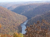
. It then flows through an impressive gorge — Cheat Canyon
Cheat Canyon
Cheat Canyon — also called Cheat River Canyon or Cheat River Gorge — is a 10-mile long, forested canyon of the Cheat River at the western edge of the Allegheny Mountains in northeastern West Virginia, USA...
— northeastwardly from Albright, collecting Big Sandy Creek
Big Sandy Creek (Cheat River)
This article refers to the Cheat River tributary in Pennsylvania and West Virginia. For the similarly named river that forms the border between Kentucky and West Virginia, see Big Sandy River ....
before entering Monongalia County
Monongalia County, West Virginia
As of the census of 2000, there were 81,866 people, 33,446 households, and 18,495 families residing in the county. The population density was 227 people per square mile . There were 36,695 housing units at an average density of 102 per square mile...
, where a hydro-electric dam
Dam
A dam is a barrier that impounds water or underground streams. Dams generally serve the primary purpose of retaining water, while other structures such as floodgates or levees are used to manage or prevent water flow into specific land regions. Hydropower and pumped-storage hydroelectricity are...
just south of the Pennsylvania border causes it to widen as the Cheat Lake
Cheat Lake
Cheat Lake is a long reservoir on the Cheat River in Monongalia County, West Virginia, USA. It was originally named Lake Lynn, but the Board on Geographic Names officially decided upon Cheat Lake as the reservoir's name in 1976. The surface area of Cheat Lake is about...
reservoir. It then flows for a short distance through southwestern Fayette County, Pennsylvania
Fayette County, Pennsylvania
Fayette County is a county located in the U.S. state of Pennsylvania. As of the2010 census, the population was 136,606. The county is part of the Pittsburgh Metropolitan Statistical Area....
, before joining the Monongahela River at Point Marion, Pennsylvania
Point Marion, Pennsylvania
Point Marion is a borough in Fayette County, Pennsylvania, United States. The population was 1,333 at the 2000 census. It is served by the Albert Gallatin Area School District.Point Marion is located at the confluence of the Monongahela and Cheat Rivers...
. Upstream of its dam, the Cheat is one of the largest undammed watersheds in the eastern United States.
Cheat Mountain
Cheat Mountain
Cheat Mountain is an exceptionally high and rugged ridge situated in the Allegheny Mountains of eastern West Virginia, USA. It is about long and more than five miles wide at its widest. Its highest point is at its southernmost end at Thorny Flat, which has an elevation of...
, a high and rugged ridge, runs about 50 miles (80.5 km) southward from its northernmost tip, just a few miles west of the confluence at Parsons.
Name
The Delaware IndianLenape
The Lenape are an Algonquian group of Native Americans of the Northeastern Woodlands. They are also called Delaware Indians. As a result of the American Revolutionary War and later Indian removals from the eastern United States, today the main groups live in Canada, where they are enrolled in the...
name for Cheat was reportedly Ach-sin-ha-nac, meaning "stony river". "Cheat River" is variously reported to have been named for (1) a French
France
The French Republic , The French Republic , The French Republic , (commonly known as France , is a unitary semi-presidential republic in Western Europe with several overseas territories and islands located on other continents and in the Indian, Pacific, and Atlantic oceans. Metropolitan France...
explorer (or an Indian) named Cheat or Chaet, (2) an abundance of cheat grass along its banks (possibly a misidentification of frost-killed wheat), or (3) deceptively deep sections containing whirlpools that presumably "cheated" men of their lives by drowning them. None of these theories have strong documentary support, but the latter is the most often cited.
Historical names
According to the Geographic Names Information SystemGeographic Names Information System
The Geographic Names Information System is a database that contains name and locative information about more than two million physical and cultural features located throughout the United States of America and its territories. It is a type of gazetteer...
, the Cheat River has formerly been known as:
- Ach-sin-ha-nac
- Achsinhanac
- Cheal River
- Chealt River
- Eleat River
- Wilmoths River
Early history
According to George W. Atkinson (1876), "From 1765 to 1774 there were comparatively few attacks made upon the white colonists by the Indians. The Treaty of ParisTreaty of Paris (1763)
The Treaty of Paris, often called the Peace of Paris, or the Treaty of 1763, was signed on 10 February 1763, by the kingdoms of Great Britain, France and Spain, with Portugal in agreement. It ended the French and Indian War/Seven Years' War...
resulted in general peace along the frontiers, had been pretty generally adhered to by all the savage tribes. The peace, however, which had for nine years blessed and fostered the frontier settlements, was suddenly broken by the murder of several friendly Indians, in 1774, on the Monongahela and Cheat rivers. This unfortunate aggression on the part of these white men gave rise to a general raid by the Indians upon all the settlements of the frontier."
The Virginia General Assembly
Virginia General Assembly
The Virginia General Assembly is the legislative body of the Commonwealth of Virginia, and the oldest legislative body in the Western Hemisphere, established on July 30, 1619. The General Assembly is a bicameral body consisting of a lower house, the Virginia House of Delegates, with 100 members,...
authorized the first two ferries
Ferry
A ferry is a form of transportation, usually a boat, but sometimes a ship, used to carry primarily passengers, and sometimes vehicles and cargo as well, across a body of water. Most ferries operate on regular, frequent, return services...
on the Cheat River in 1806. On January 2, a ferry in Monongalia County was approved on Charles Stuart property to James Stafford property. On January 18, the Assembly authorized the second ferry in Monongalia County from the forge location of Samuel Jackson to Charles Magill property. Another act in 1806 authorized to conduct a lottery to fund the construction of a toll bridge across Cheat River near Dunker Bottom in Monongalia County. Concerned included Michael Kern, John Stealy, Augustus Werninger, Ralph Barkshire, and William N. Jarrett. The Assembly also authorized in 1806 the construction of mill dams across the Monongahela River, Cheat River, Tygart Valley River
Tygart Valley River
The Tygart Valley River — also known as the Tygart River — is a principal tributary of the Monongahela River, approximately long, in east-central West Virginia, USA...
, or the West Fork
West Fork River
The West Fork River is a principal tributary of the Monongahela River, 103 miles long, in north-central West Virginia in the United States...
of the Monongahela River.
A state militia facility, Camp Dawson
Camp Dawson (West Virginia)
Camp Dawson is a West Virginia Army National Guard facility in Preston County, West Virginia, USA.Camp Dawson was established on May 7, 1909 when the West Virginia Legislature authorized the purchase of of land on Dunkard Bottom along the Cheat River. The camp was named in honor of William M. O....
, was established on the banks of the Cheat in Preston County in 1909 and continues in operation today.
1985 flood
In November 1985, heavy rains caused a massive flood on the Cheat, essentially wiping out the small town of AlbrightAlbright, West Virginia
Albright is a town in Preston County, West Virginia, United States, along the Cheat River. The population was 247 at the 2000 census.-History:Located near Albright is the Virginia Furnace, listed on the National Register of Historic Places in 1999....
. The river flow was estimated at 190,000 cubic feet per second, much larger than normal flows ranging from 1,000 to 5,000 cubic feet per second. The massive flood also caused the Cheat River to leave its banks and flood the small town of Rowlesburg
Rowlesburg, West Virginia
Rowlesburg is a town in Preston County, West Virginia, United States, along the Cheat River. The population was 613 at the 2000 census.-History:The Downtown Rowlesburg Historic District was listed on the National Register of Historic Places in 2005....
. The town lost many businesses, and many families left their homes or the land that they owned. The flood also wiped out the school in Rowlesburg, which caused the consolidation of a high school for the county. The devastation was caused not so much by the steady-state flow of water, but rather by the repeated damming of the river by debris under the various road and railroad bridges that crossed the Cheat. Thus as the flood proceeded down the river, the water would rise behind the obstructed bridge, break through the inadvertent dam, and pick up more debris that would block the river at the next bridge site, repeating the process.
Pollution
In the vicinity of Albright, the Cheat has been plagued by pollutionWater pollution
Water pollution is the contamination of water bodies . Water pollution occurs when pollutants are discharged directly or indirectly into water bodies without adequate treatment to remove harmful compounds....
, notably acid mine drainage
Acid mine drainage
Acid mine drainage , or acid rock drainage , refers to the outflow of acidic water from metal mines or coal mines. However, other areas where the earth has been disturbed may also contribute acid rock drainage to the environment...
. Although the rocks downstream of Albright have been stained a rust brown, and the river has a very low fish population below Albright, water quality
Water quality
Water quality is the physical, chemical and biological characteristics of water. It is a measure of the condition of water relative to the requirements of one or more biotic species and or to any human need or purpose. It is most frequently used by reference to a set of standards against which...
has been making slow improvements since the 1990s. Friends of the Cheat, the local river advocacy organization, has been instrumental in promoting remediation, cleanup, river stewardship, and education.
Whitewater recreation
The Cheat CanyonCheat Canyon
Cheat Canyon — also called Cheat River Canyon or Cheat River Gorge — is a 10-mile long, forested canyon of the Cheat River at the western edge of the Allegheny Mountains in northeastern West Virginia, USA...
section of the Cheat River (from Albright
Albright, West Virginia
Albright is a town in Preston County, West Virginia, United States, along the Cheat River. The population was 247 at the 2000 census.-History:Located near Albright is the Virginia Furnace, listed on the National Register of Historic Places in 1999....
to Jenkinsburg, West Virginia), which features Class IV rapids
International Scale of River Difficulty
The International Scale of River Difficulty is a standardized scale used to rate the safety of a stretch of river, or a single rapid. The grade reflects the technical difficulty and skill level required associated with the section of river...
(and Class V rapids
International Scale of River Difficulty
The International Scale of River Difficulty is a standardized scale used to rate the safety of a stretch of river, or a single rapid. The grade reflects the technical difficulty and skill level required associated with the section of river...
at upper levels), has become a favorite destination for whitewater
Whitewater
Whitewater is formed in a rapid, when a river's gradient increases enough to disturb its laminar flow and create turbulence, i.e. form a bubbly, or aerated and unstable current; the frothy water appears white...
kayak
Kayak
A kayak is a small, relatively narrow, human-powered boat primarily designed to be manually propelled by means of a double blade paddle.The traditional kayak has a covered deck and one or more cockpits, each seating one paddler...
ing and rafting
Rafting
Rafting or white water rafting is a challenging recreational outdoor activity using an inflatable raft to navigate a river or other bodies of water. This is usually done on white water or different degrees of rough water, in order to thrill and excite the raft passengers. The development of this...
. On the first weekend in May of every year, paddlers gather from many states to attend the Cheat Festival. A very popular whitewater race—the Cheat River Race—takes place in the 10 miles (16.1 km) Cheat Canyon on the Friday of that weekend. Unlike the overwhelming majority of whitewater races
Whitewater racing
Wildwater canoeing is a competitive discipline of canoeing in which kayaks or Canadian canoes are used to negotiate a stretch of river speedily...
, which employ a staggered start, this race uses a mass start (in which all participants start at the same time). For the first few miles, paddlers must avoid one another, in addition to the whitewater hazards that the river presents. The race, which usually attracts 150 people, is often cited as the largest whitewater race in existence.
The Cheat Narrows section of the Cheat River (upstream of Albright) is also utilized by whitewater paddlers, and features Class II and III rapids
International Scale of River Difficulty
The International Scale of River Difficulty is a standardized scale used to rate the safety of a stretch of river, or a single rapid. The grade reflects the technical difficulty and skill level required associated with the section of river...
.